Cascading Landslide: Kinematic and Finite Element Method Analysis through Remote Sensing Techniques
Abstract
:1. Introduction
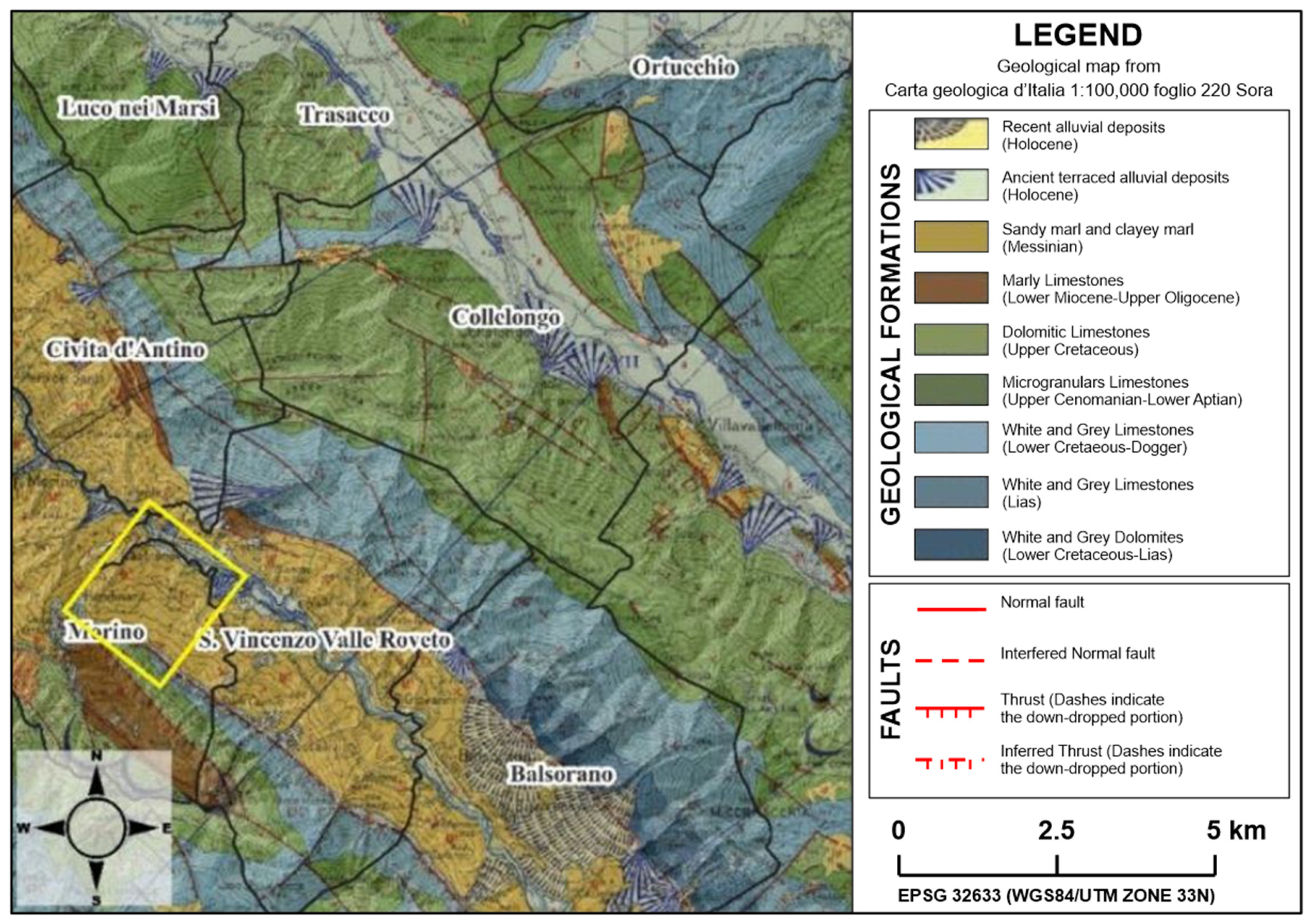
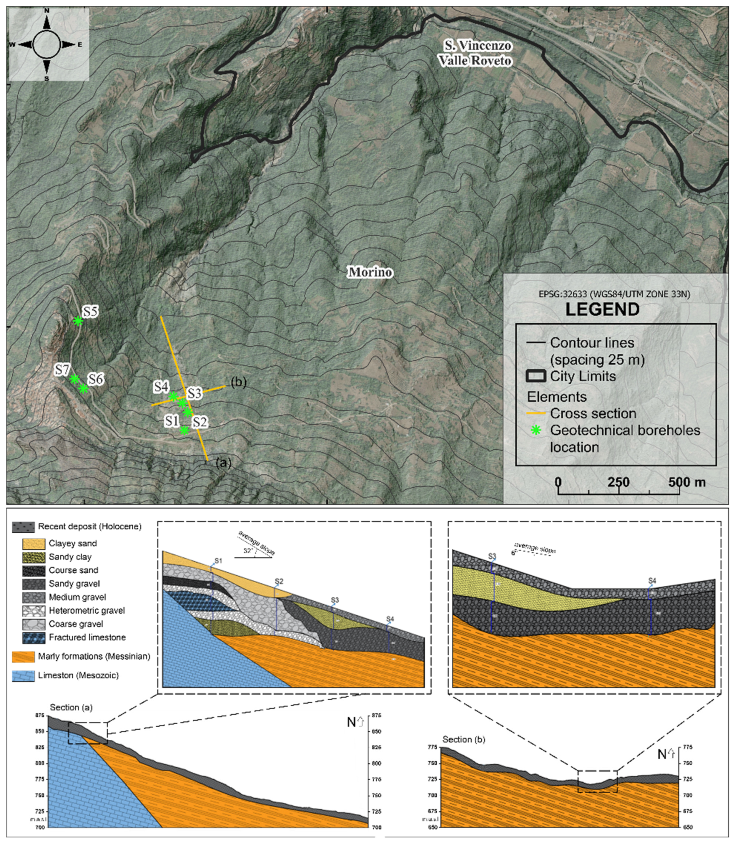
2. Study Area
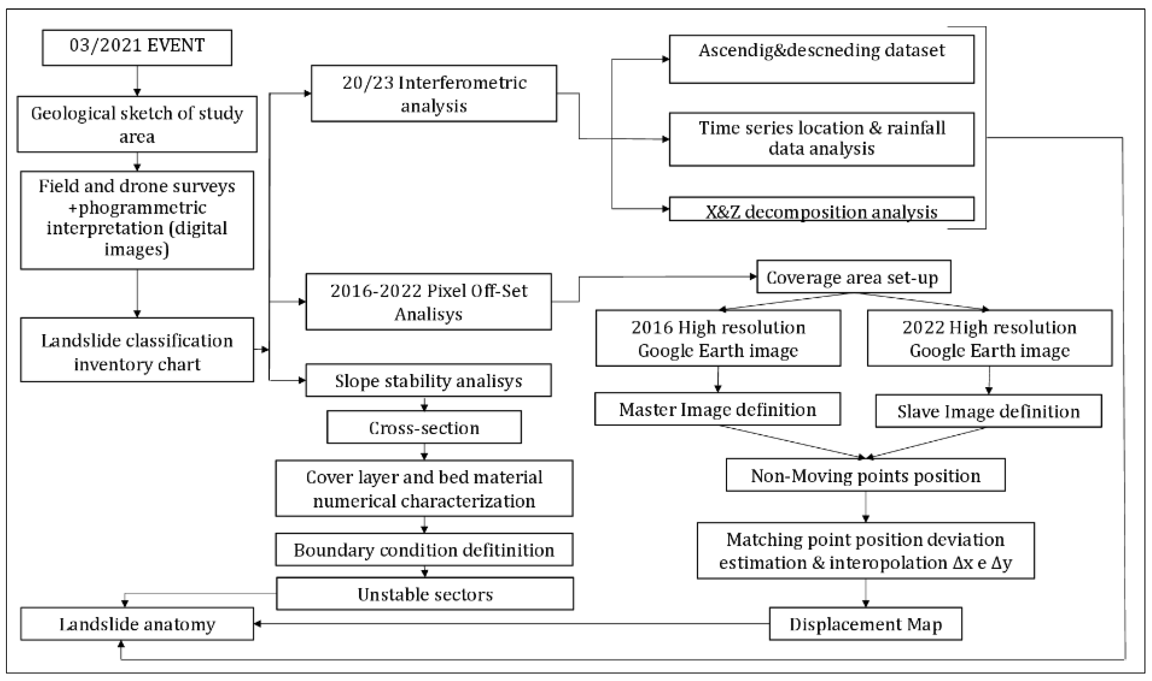
3. Materials and Methods
3.1. Field and Geomorphological Interpretation
3.2. SAR Interferometry
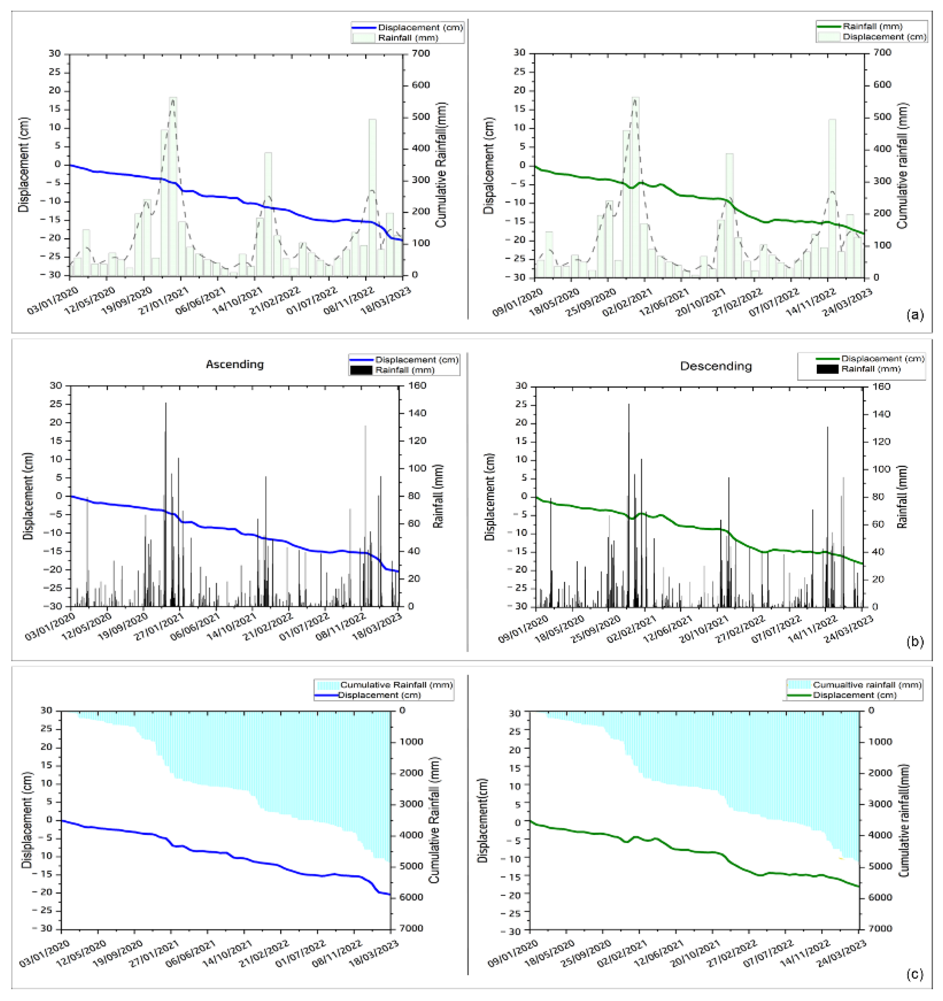
- A total of 96 images acquired in ascending geometry, covering the period from 3 January 2020 to 24 March 2023, with an incidence angle of 39.5°, generating 435 interpherograms. The image acquired on 6 September 2021 was automatically set as the master image.
- A total of 107 images acquired in descending geometry, covering the period from 9 January 2020 to 30 March 2023, with an angle of 43.6° to the vertical inclination, generating 484 interpherograms. The image acquired on 9 March 2021 was automatically set as the master.
3.3. Pixel Offset
3.4. Rainfall Analyses
3.5. Slope Stability Analysis
4. Results
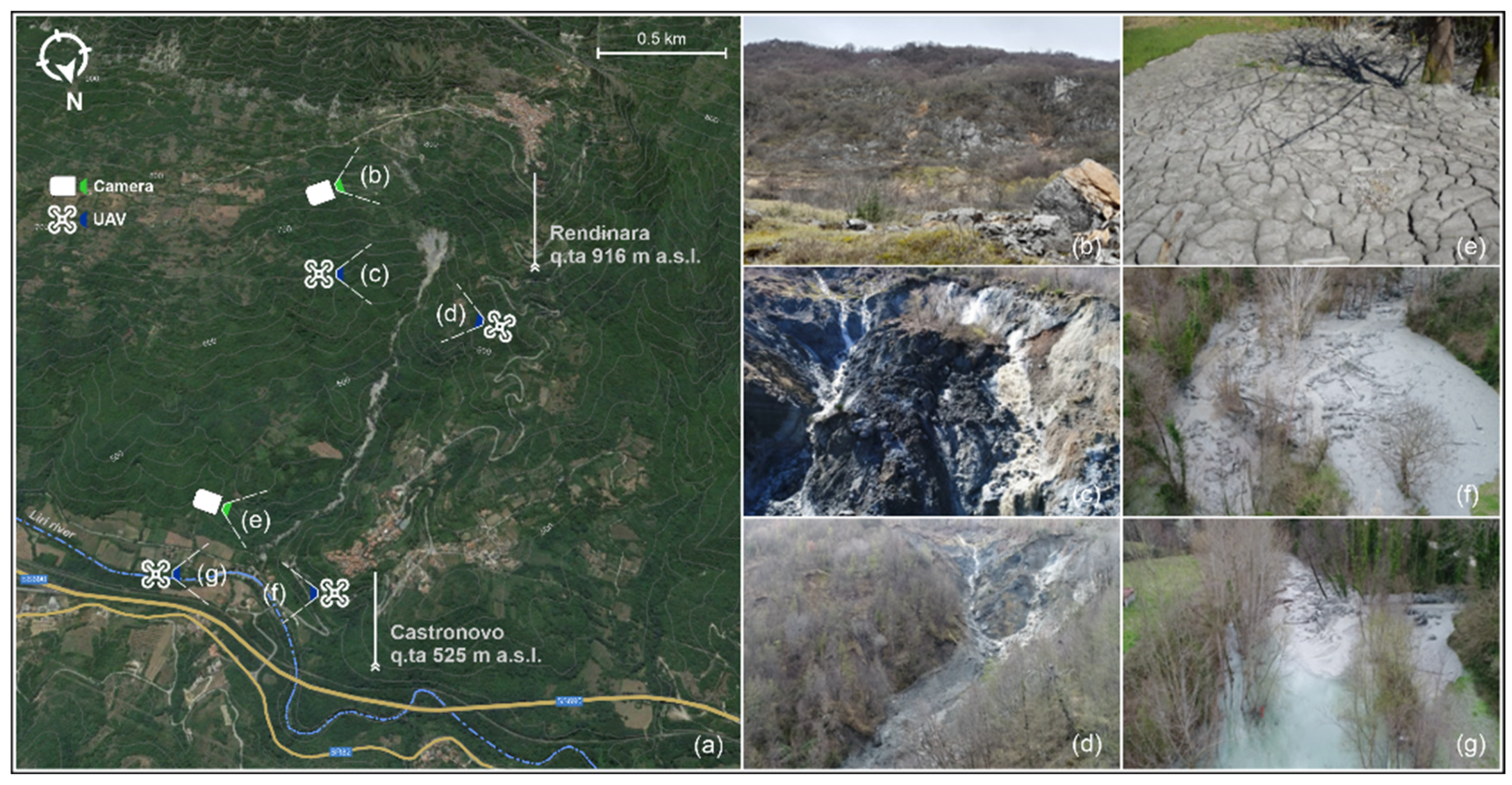
4.1. Field Observations, Imaging Interpretation, and Pixel Offset Results
4.2. Interferometric Data Results
4.3. Rainfall Landslide Movement Influence and Slope Stability Analysis
5. Discussion
6. Conclusions
Author Contributions
Funding
Data Availability Statement
Acknowledgments
Conflicts of Interest
References
- Hungr, O.; Leroueil, S.; Picarelli, L. The Varnes Classification of Landslide Types, an Update. Landslides 2014, 11, 167–194. [Google Scholar] [CrossRef]
- Kirschbaum, D.B.; Adler, R.; Hong, Y.; Hill, S.; Lerner-Lam, A. A Global Landslide Catalog for Hazard Applications: Method, Results, and Limitations. Nat. Hazards 2010, 52, 561–575. [Google Scholar] [CrossRef]
- Smith, K.; Petley, D.N. Environmental Hazards: Assessing Risk and Reducing Disaster; Routledge: London, UK, 2013. [Google Scholar]
- Wu, Z.; Barosh, P.J.; Ha, G.; Yao, X.; Xu, Y.; Liu, J. Damage Induced by the 25 April 2015 Nepal Earthquake in the Tibetan Border Region of China and Increased Post-Seismic Hazards. Nat. Hazards Earth Syst. Sci. 2019, 19, 873–888. [Google Scholar] [CrossRef]
- Abbate, A.; Longoni, L.; Ivanov, V.I.; Papini, M. Wildfire Impacts on Slope Stability Triggering in Mountain Areas. Geosciences 2019, 9, 417. [Google Scholar] [CrossRef]
- Varnes, D. Slope Movement Types and Processes. Spec. Rep. 1978, 176, 11–33. [Google Scholar]
- Iverson, R.M.; Reid, M.E.; LaHusen, R.G. Debris-Flow Mobilization from Landslides. Annu. Rev. Earth Planet. Sci. 1997, 25, 85–138. [Google Scholar] [CrossRef]
- Fell, R.; Glastonbury, J.; Hunter, G. Rapid Landslides: The Importance of Understanding Mechanisms and Rupture Surface Mechanics. Q. J. Eng. Geol. Hydrogeol. 2007, 40, 9–27. [Google Scholar] [CrossRef]
- Iverson, R.M.; George, D.L.; Allstadt, K.; Reid, M.E.; Collins, B.D.; Vallance, J.W.; Schilling, S.P.; Godt, J.W.; Cannon, C.M.; Magirl, C.S.; et al. Landslide Mobility and Hazards: Implications of the 2014 Oso Disaster. Earth Planet. Sci. Lett. 2015, 412, 197–208. [Google Scholar] [CrossRef]
- Turner, A.K. Social and Environmental Impacts of Landslides. Innov. Infrastruct. Solut. 2018, 3, 70. [Google Scholar] [CrossRef]
- Pudasaini, S.P.; Krautblatter, M. The Landslide Velocity. Earth Surf. Dyn. 2022, 10, 165–189. [Google Scholar] [CrossRef]
- Allen, S.K.; Rastner, P.; Arora, M.; Huggel, C.; Stoffel, M. Lake Outburst and Debris Flow Disaster at Kedarnath, June 2013: Hydrometeorological Triggering and Topographic Predisposition. Landslides 2016, 13, 1479–1491. [Google Scholar] [CrossRef]
- Usamah, M. Analysis of the Causal and Trigger Factors of the August 2017 Landslide in Freetown: Towards a Sustainable Landslide Risk Management in Sierra Leone; United Nations Development Program (UNDP) and Environmental Protection Agency (EPA): New York, NY, USA, 2017. [Google Scholar]
- Zito, C.; Mangifesta, M.; Francioni, M.; Guerriero, L.; Di Martire, D.; Calcaterra, D.; Pasculli, A.; Sciarra, N. Cascading landslide at Morino-Rendinara, L’Aquila, Central Italy: Numerical modelling of slope-scale prospective debris flow propagation. Ital. J. Eng. Geol. Environ. 2024, 285–293. [Google Scholar] [CrossRef]
- Bouzid, D.A. Finite Element Analysis of Slope Stability by Expanding the Mobilized Principal Stress Mohr’s Circles—Development, Encoding and Validation. J. Rock Mech. Geotech. Eng. 2022, 14, 1165–1179. [Google Scholar] [CrossRef]
- Google Earth Pro 7.3.6.9796. (February 22, 2024). Morino-Rendinara, Italy. 41°50′25.50″N, 13°28′28.79″E. Digital Globe August 2021 and March 2022. Available online: www.google.com/earth/index.html (accessed on 1 March 2024).
- Saroli, M.; Biasini, A.; Cavinato, G.P.; Di Luzio, E. Geological Setting of the Southern Sector of the Roveto Valley (Central Apennines, Italy). Boll. Della Soc. Geol. Ital. 2003, 122, 467–481. [Google Scholar]
- Fabbi, S. Geology of the Eastern Slopes of the Simbruini Mts. Between Verrecchie and Capistrello (Central Apennines—Abruzzo, Italy). J. Maps 2018, 14, 435–446. [Google Scholar] [CrossRef]
- Parotto, M. Stratigrafy and Tectonics of the Eastern Simbruini and Western Marsica Ranges (Central Apennines—Italy). Atti Accad. Naz. Lincei 1971, 8, 93–170. [Google Scholar]
- Maceroni, D.; Dixit Dominus, G.; Gori, S.; Falcucci, E.; Galadini, F.; Moro, M.; Saroli, M. First Evidence of the Late Pleistocene—Holocene Activity of the Roveto Valley Fault (Central Apennines, Italy). Front. Earth Sci. 2022, 10, 1018737. [Google Scholar] [CrossRef]
- Cosentino, D.; Cipollari, P. The Messinian Central Apennines. Rend. Online Soc. Geol. Ital. 2012, 23, 45–51. [Google Scholar]
- CARG Project in Geological Itanlian Chart 1:100,000 Foglio Carta Geologica d’Italia 1:100,000 n. 152 Sora Progetto—CARG. 1976. Available online: https://sgi.isprambiente.it/geologia100k/mostra_foglio.aspx?numero_foglio=152 (accessed on 1 March 2024).
- Sciarra, N.; Mangifesta, M.; Carabba, L.; Mischiatti, L. Methodological Approach for the Study of Historical Centres of High Architectural Value Affected by Geo-Hydrological Hazards: The Case of Lanciano (Abruzzo Region—Central Italy). Geosciences 2022, 12, 193. [Google Scholar] [CrossRef]
- Costantini, M.; Ferretti, A.; Minati, F.; Falco, S.; Trillo, F.; Colombo, D.; Novali, F.; Malvarosa, F.; Mammone, C.; Vecchioli, F.; et al. Analysis of Surface Deformations over the Whole Italian Territory by Interferometric Processing of ERS, Envisat and COSMO-SkyMed Radar Data. Remote Sens. Environ. 2017, 202, 250–275. [Google Scholar] [CrossRef]
- Mora, P.; Baldi, P.; Casula, G.; Fabris, M.; Ghirotti, M.; Mazzini, E.; Pesci, A. Global Positioning Systems and Digital Photogrammetry for the Monitoring of Mass Movements: Application to the Ca’ Di Malta Landslide (Northern Apennines, Italy). Eng. Geol. 2003, 68, 103–121. [Google Scholar] [CrossRef]
- Mallorqui, J.J.; Mora, O.; Blanco, P.; Broquetas, A. Linear and Non-Linear Long-Term Terrain Deformation with DInSAR (CPT: Coherent Pixels Technique). In Proceedings of the FRINGE 2003 Workshop (ESA SP-550), Frascati, Italy, 1–5 December 2003. [Google Scholar]
- Guerriero, L.; Di Martire, D.; Calcaterra, D.; Francioni, M. Digital Image Correlation of Google Earth Images for Earth’s Surface Displacement Estimation. Remote Sens. 2020, 12, 3518. [Google Scholar] [CrossRef]
- Zheng, H.; Tian, B.; Liu, D.F.; Feng, Q. Definitions of Safety Factor of Slope Stability Analysis with Finite Element Method. Yanshilixue Yu Gongcheng Xuebao Chin. J. Rock Mech. Eng. 2005, 24, 2225–2230. [Google Scholar]
- Geraili Mikola, R. ADONIS: A Free Finite Element Analysis Software with an Interactive Graphical User Interface for Geoengineers. In Proceedings of the GeoOttawa 2017, Ottawa, ON, Canada, 1–4 October 2017. [Google Scholar]
- Chen, B. Finite Element Strength Reduction Analysis on Slope Stability Based on ANSYS. Environ. Earth Sci. Res. J. 2017, 4, 60–65. [Google Scholar] [CrossRef]
- Quamar, M.M.; Al-Ramadan, B.; Khan, K.; Shafiullah, M.; El Ferik, S. Advancements and Applications of Drone-Integrated Geographic Information System Technology—A Review. Remote Sens. 2023, 15, 5039. [Google Scholar] [CrossRef]
- Iglesias, R.; Mallorqui, J.J.; Monells, D.; López-Martínez, C.; Fabregas, X.; Aguasca, A.; Gili, J.A.; Corominas, J. PSI Deformation Map Retrieval by Means of Temporal Sublook Coherence on Reduced Sets of SAR Images. Remote Sens. 2015, 7, 530–563. [Google Scholar] [CrossRef]
- The MathWorks Inc. MATLAB. 2023. Available online: https://it.mathworks.com/products/matlab.html (accessed on 1 March 2024).
- Cascini, L.; Fornaro, G.; Peduto, D. Advanced Low- and Full-Resolution DInSAR Map Generation for Slow-Moving Landslide Analysis at Different Scales. Eng. Geol. 2010, 112, 29–42. [Google Scholar] [CrossRef]
- Sato, H.P.; Harp, E.L. Interpretation of Earthquake-Induced Landslides Triggered by the 12 May 2008, M7.9 Wenchuan Earthquake in the Beichuan Area, Sichuan Province, China Using Satellite Imagery and Google Earth. Landslides 2009, 6, 153–159. [Google Scholar] [CrossRef]
- QuantumGis 3.18 Geographic Information System; QGIS Association 2023. Available online: www.qgis.org (accessed on 1 March 2024).
- Berger, M. Geometry I; Springer: Berlin/Heidelberg, Germany, 1987; ISBN 3-540-11658-3. [Google Scholar]
- Govender, N. Evaluation of Feature Detection Algorithms for Structure from Motion; CSIR: Pretoria, South Africa, 2009. [Google Scholar]
- Lucas, B.; Kanade, T. An iterative image registration technique with an application to stereo vision. In Proceedings of the 7th International Joint Conference on Artificial Intelligence, San Francisco, CA, USA, 24–28 August 1981; pp. 674–679. [Google Scholar]
- Regione Abruzzo—Servizio Idrografico e Mareografico. Available online: https://www.regione.abruzzo.it/content/servizio-idrografico-mareografico (accessed on 1 March 2024).
- Mohammadi, S. Extended Finite Element Method: For Fracture Analysis of Structures; John Wiley & Sons: Hoboken, NJ, USA, 2008. [Google Scholar]
- Guerriero, L.; Guadagno, F.M.; Revellino, P. Estimation of Earth-Slide Displacement from GPS-Based Surface-Structure Geometry Reconstruction: Estimation of Earth-Slide Displacement. Landslides 2019, 16, 425–430. [Google Scholar] [CrossRef]
- Gabriel, A.K.; Goldstein, R.M.; Zebker, H.A. Mapping Small Elevation Changes over Large Areas: Differential Radar Interferometry. J. Geophys. Res. 1989, 94, 9183–9191. [Google Scholar] [CrossRef]
- Casagli, N.; Catani, F.; Del Ventisette, C.; Luzi, G. Monitoring, Prediction, and Early Warning Using Ground-Based Radar Interferometry. Landslides 2010, 7, 291–301. [Google Scholar] [CrossRef]
- Di Martire, D.; Novellino, A.; Tessitore, S.; Ramondini, M.; Calcaterra, D. Application of DInSAR Techniques to Engineering Geology Studies in Southern Italy. Rend. Online Soc. Geol. Ital. 2013, 24, 95–97. [Google Scholar]
- Morgenstern, N.R.; Price, V.E.; Morgenstern, N.R.; Price, V.E. The Analysis of the Stability of General Slip Surfaces. Géotechnique 1965, 15, 79–93. [Google Scholar] [CrossRef]
- Bianchini, S.; Solari, L.; Bertolo, D.; Thuegaz, P.; Catani, F. Integration of Satellite Interferometric Data in Civil Protection Strategies for Landslide Studies at a Regional Scale. Remote Sens. 2021, 13, 1881. [Google Scholar] [CrossRef]
- Khandelwal, D.D.; Gahalaut, V.; Kumar, N.; Kundu, B.; Yadav, R.K. Seasonal Variation in the Deformation Rate in NW Himalayan Region. Nat. Hazards 2014, 74, 1853–1861. [Google Scholar] [CrossRef]
- Guo, Z.; Ferrer, J.V.; Hürlimann, M.; Medina, V.; Puig-Polo, C.; Yin, K.; Huang, D. Shallow Landslide Susceptibility Assessment under Future Climate and Land Cover Changes: A Case Study from Southwest China. Geosci. Front. 2023, 14, 101542. [Google Scholar] [CrossRef]
- Van den Bout, B.; Lombardo, L.; Chiyang, M.; van Westen, C.; Jetten, V. Physically-Based Catchment-Scale Prediction of Slope Failure Volume and Geometry. Eng. Geol. 2021, 284, 105942. [Google Scholar] [CrossRef]






| Ascending | Descending | Applied Formula |
|---|---|---|
| Yes | Yes | |
| Yes | No | |
| No | Yes |
| Parameter | Mesozoic Limestone | Messinian Clay | Cover Layer |
|---|---|---|---|
| Unit weight (kg/m3) | 2750 | 2200 | 2300 |
| Young (Pa) | 1.2 × 10¹⁰ | 3.1 × 10⁹ | 1.5 × 10⁹ |
| Poisson | 0.30 | 0.25 | 0.25 |
| ϕ (°) | - | - | 27 |
| c (Pa) | - | - | 1.8 × 10⁴ |
| Type | Iso-elastic | Iso-elastic | Mohr–Coulomb |
| Shear Modulus (Pa) | 4.6 × 10⁹ | 1.2 × 10⁹ | 6.0 × 10⁸ |
| Bulk Modulus (Pa) | 1.0 × 10¹⁰ | 2.1 × 10⁹ | 1.0 × 10⁹ |
Disclaimer/Publisher’s Note: The statements, opinions and data contained in all publications are solely those of the individual author(s) and contributor(s) and not of MDPI and/or the editor(s). MDPI and/or the editor(s) disclaim responsibility for any injury to people or property resulting from any ideas, methods, instructions or products referred to in the content. |
© 2024 by the authors. Licensee MDPI, Basel, Switzerland. This article is an open access article distributed under the terms and conditions of the Creative Commons Attribution (CC BY) license (https://creativecommons.org/licenses/by/4.0/).
Share and Cite
Zito, C.; Mangifesta, M.; Francioni, M.; Guerriero, L.; Di Martire, D.; Calcaterra, D.; Sciarra, N. Cascading Landslide: Kinematic and Finite Element Method Analysis through Remote Sensing Techniques. Remote Sens. 2024, 16, 3423. https://doi.org/10.3390/rs16183423
Zito C, Mangifesta M, Francioni M, Guerriero L, Di Martire D, Calcaterra D, Sciarra N. Cascading Landslide: Kinematic and Finite Element Method Analysis through Remote Sensing Techniques. Remote Sensing. 2024; 16(18):3423. https://doi.org/10.3390/rs16183423
Chicago/Turabian StyleZito, Claudia, Massimo Mangifesta, Mirko Francioni, Luigi Guerriero, Diego Di Martire, Domenico Calcaterra, and Nicola Sciarra. 2024. "Cascading Landslide: Kinematic and Finite Element Method Analysis through Remote Sensing Techniques" Remote Sensing 16, no. 18: 3423. https://doi.org/10.3390/rs16183423
APA StyleZito, C., Mangifesta, M., Francioni, M., Guerriero, L., Di Martire, D., Calcaterra, D., & Sciarra, N. (2024). Cascading Landslide: Kinematic and Finite Element Method Analysis through Remote Sensing Techniques. Remote Sensing, 16(18), 3423. https://doi.org/10.3390/rs16183423


