
Surface Solar Radiation Resource Evaluation of Xizang Region Based on Station Observation and High-Resolution Satellite Dataset


Abstract
:1. Introduction
- (1)
- Analyzed the characteristics of differences between high-resolution product data and station data at spatial and temporal scales in Xizang province.
- (2)
- Carried out solar radiation variability studies and altitude correlation studies.
- (3)
- Evaluated Xizang’s solar radiation resources at a multidimensional scale to provide prioritization recommendations for regional development.

2. Area and Data
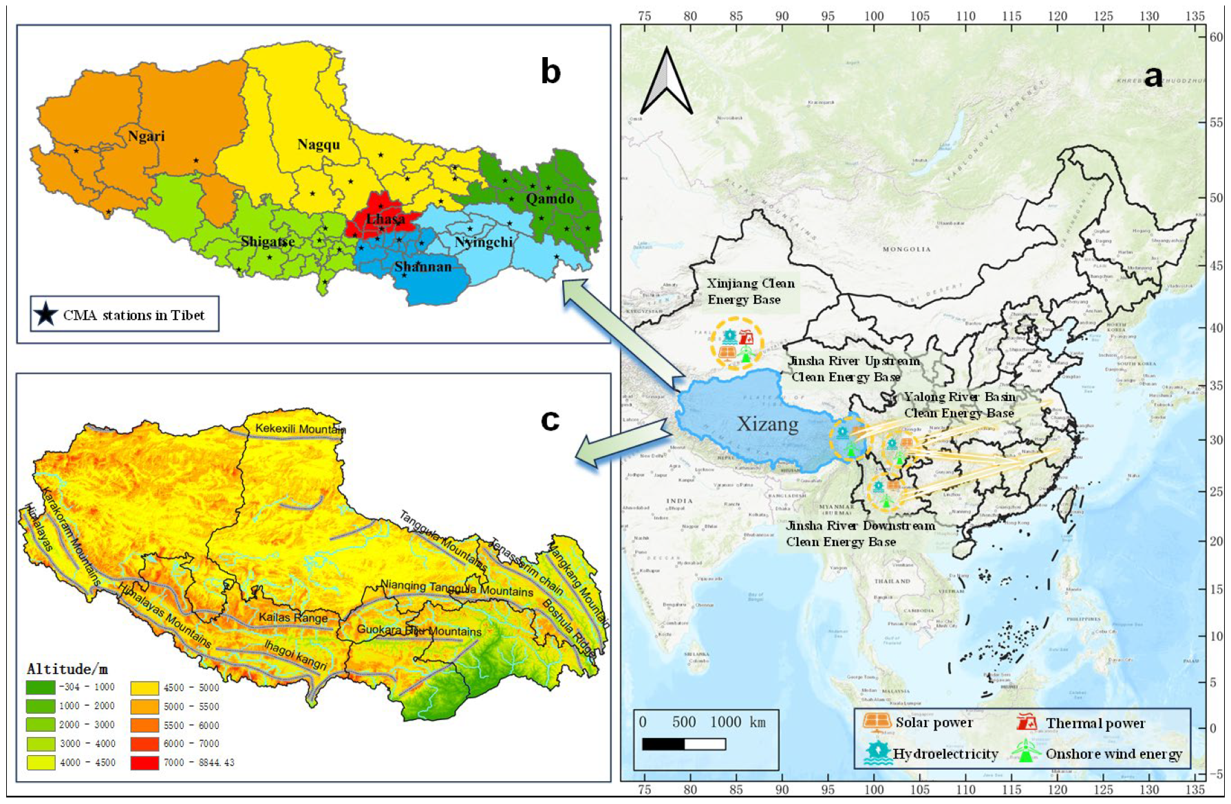
2.1. Study Area
2.2. Data
3. Methods
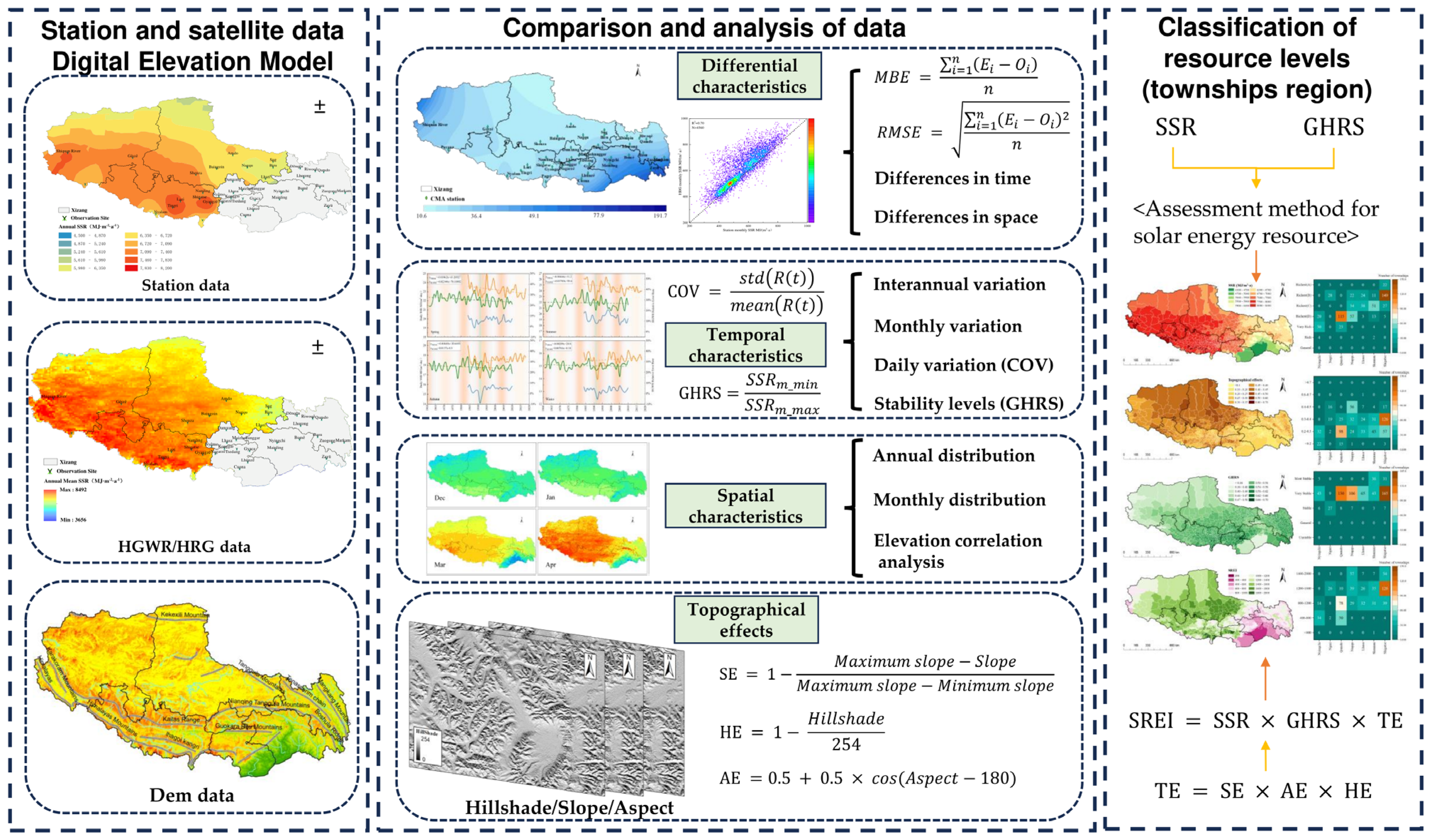
3.1. Evaluation Metrics and Methods
3.2. Calculation of Variability
3.3. Evaluation of Solar Resources
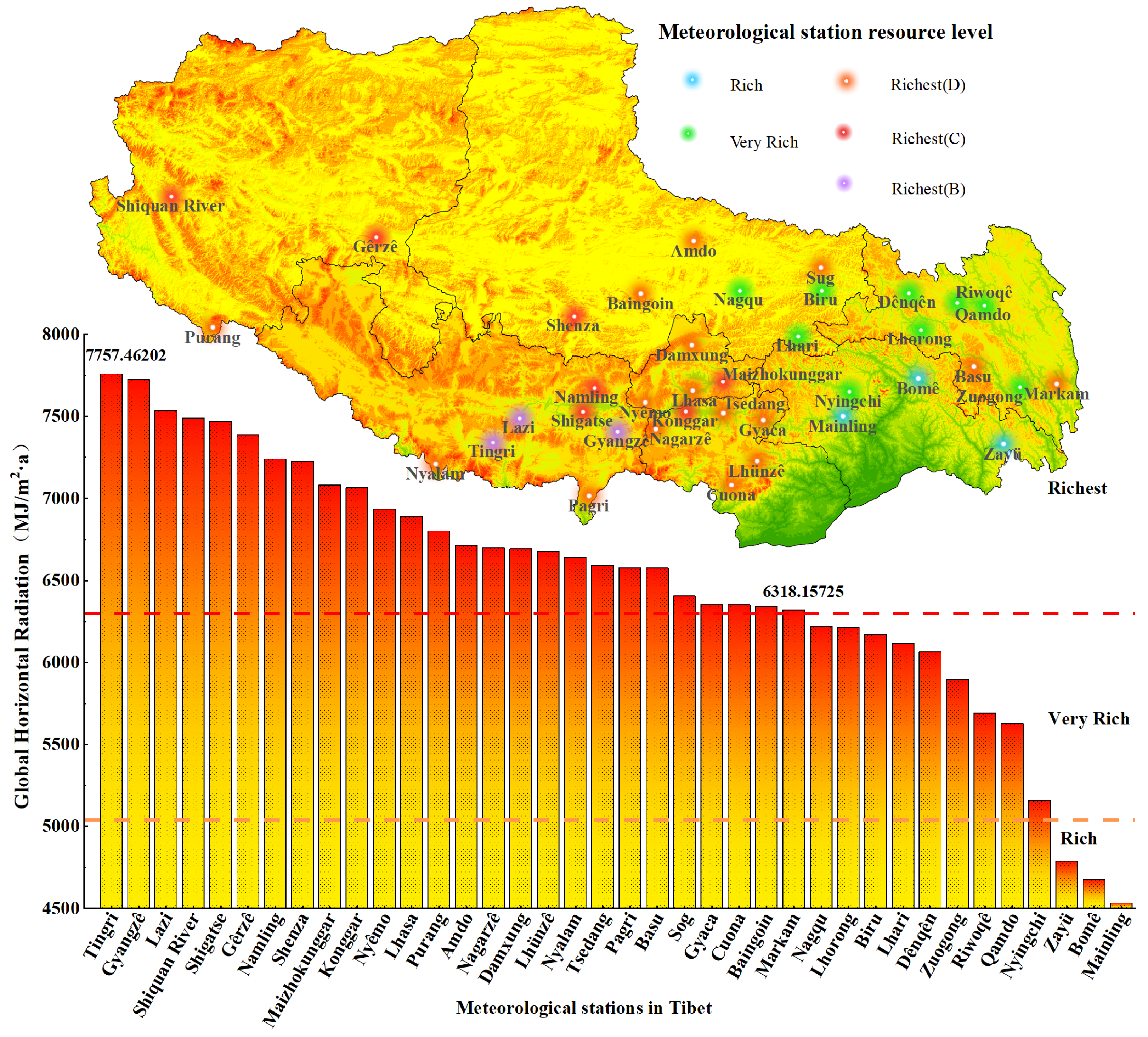
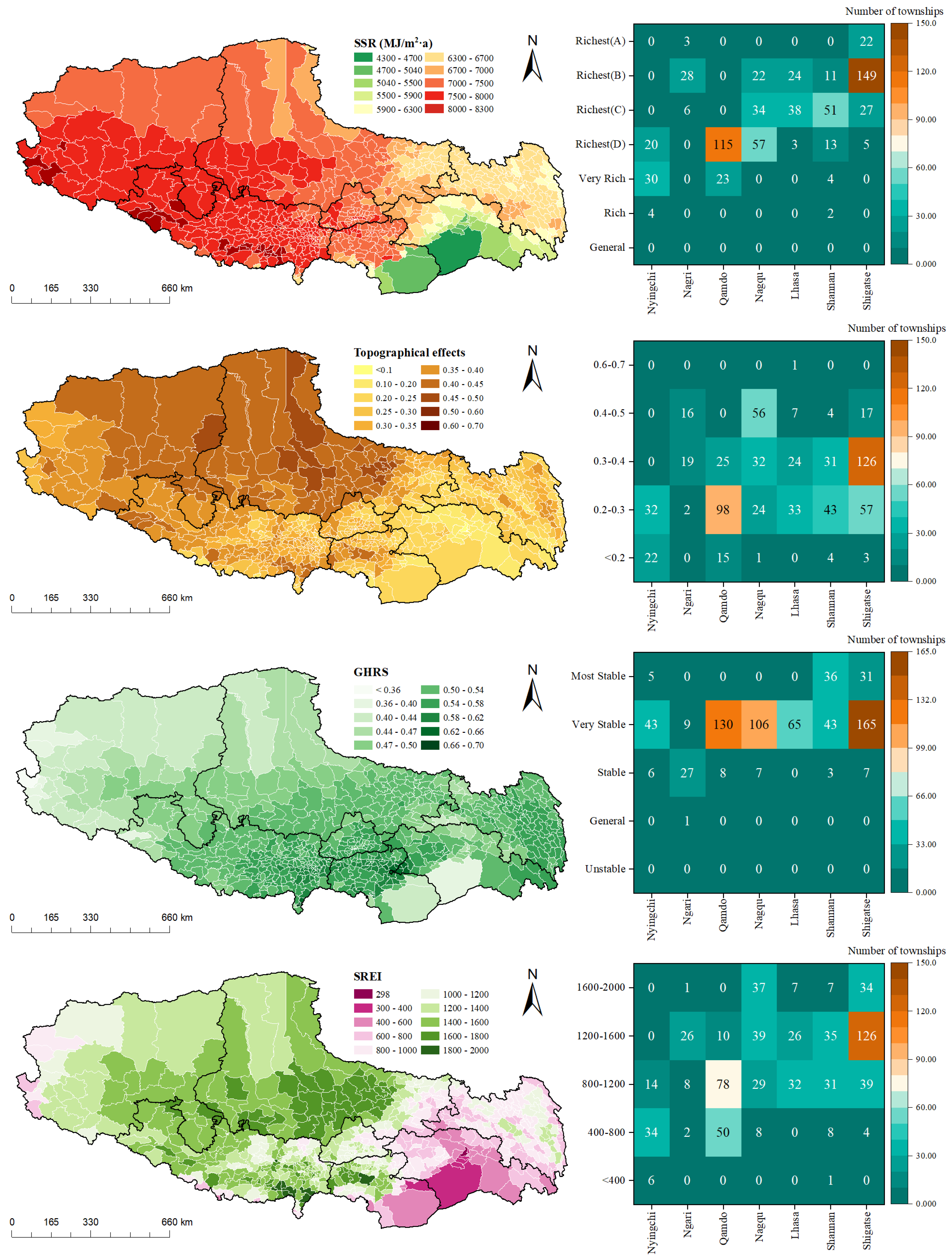
3.3.1. Abundance and Stability Levels of SSR
3.3.2. Topographic Effect and Solar Resource Evaluation Indicator
4. Results and Analysis
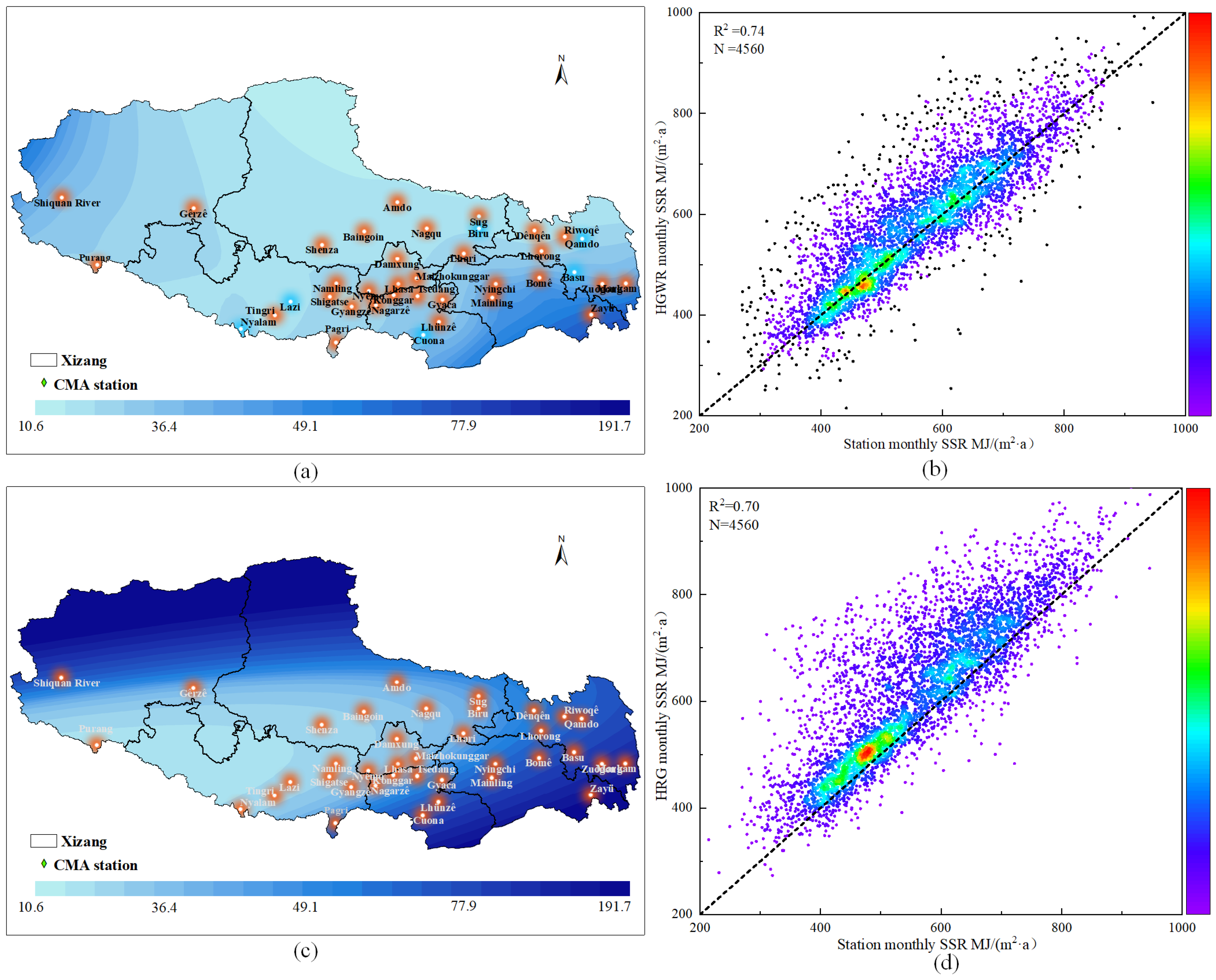
4.1. Differences between High-Resolution Data and Station Data
4.2. Surface Solar Radiation Distribution in Xizang
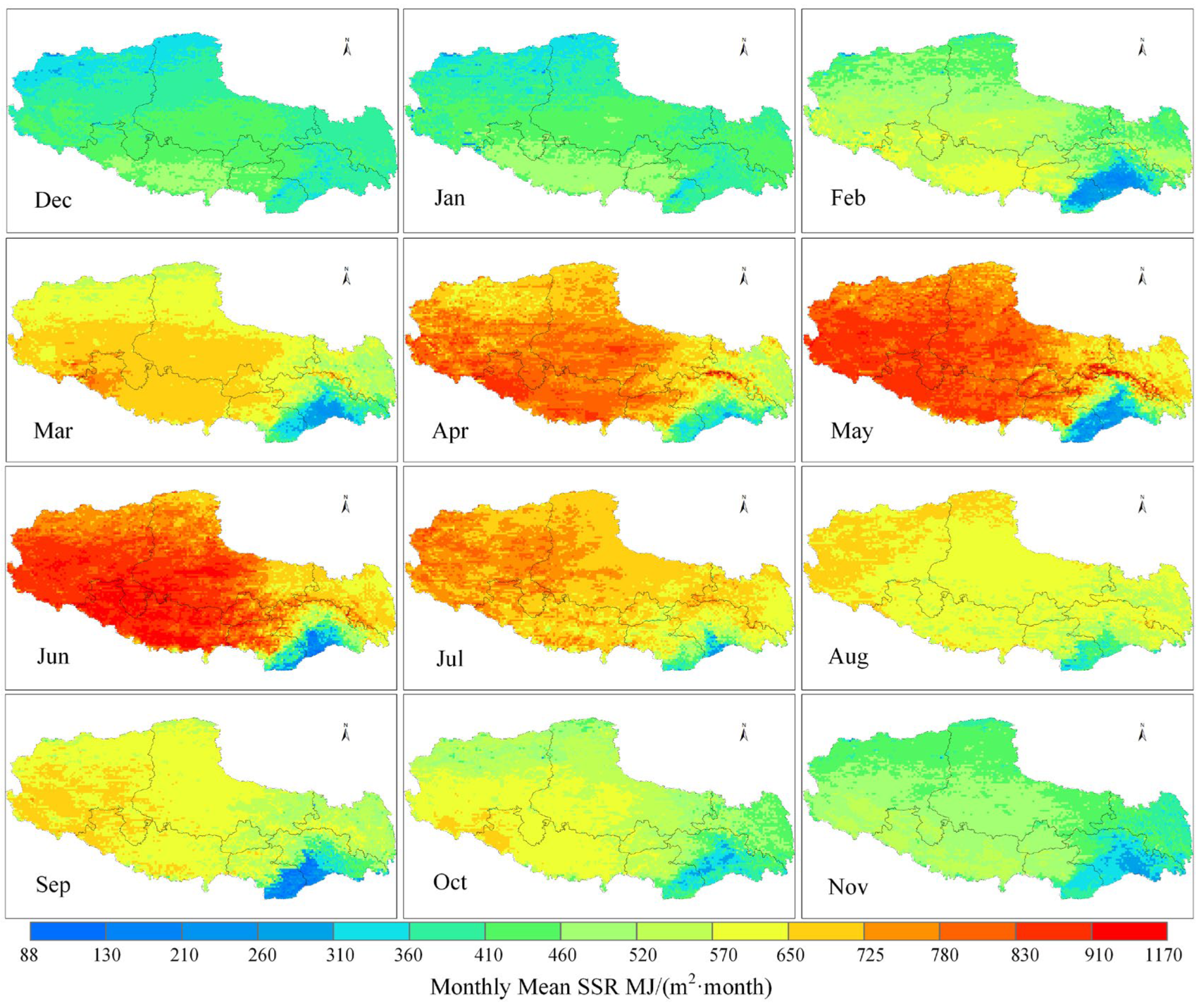
4.2.1. Annual and Monthly SSR Distribution
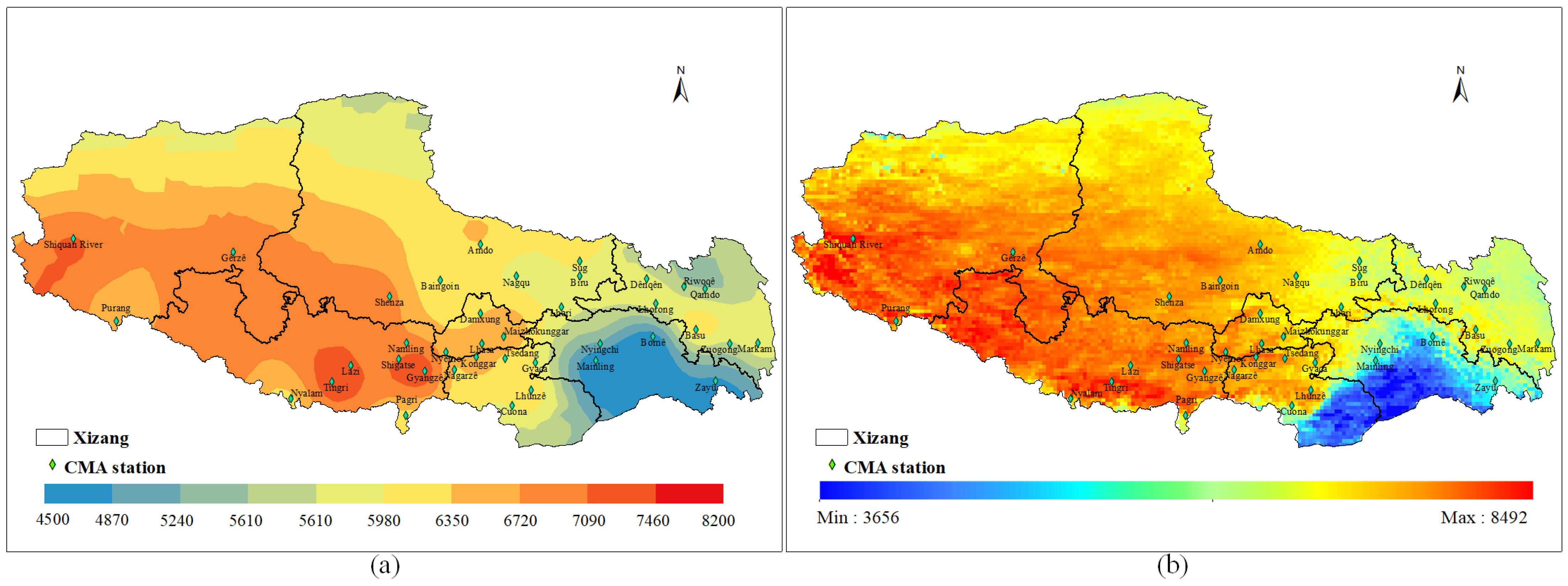
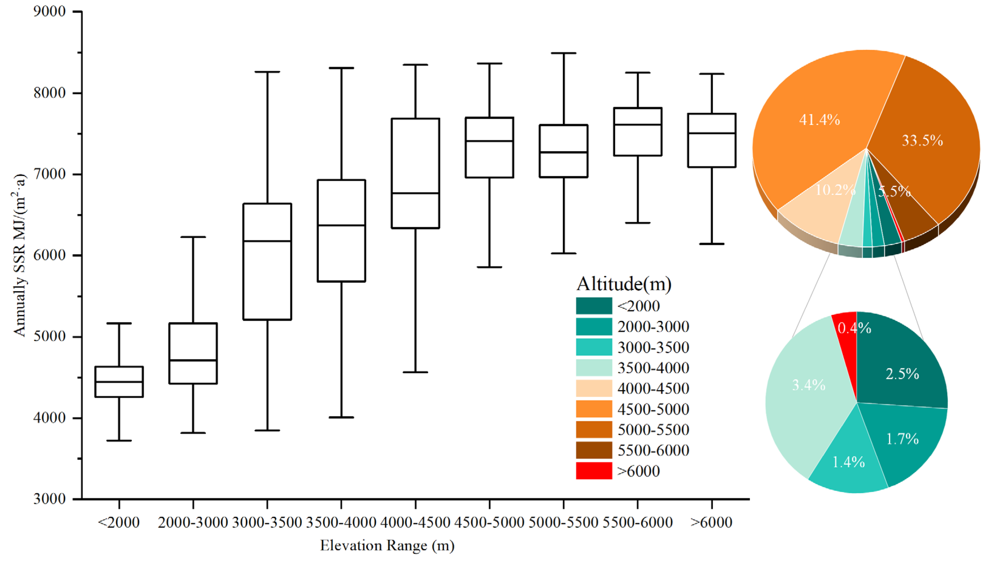
4.2.2. Elevation Affecting SSR
4.3. Surface Solar Radiation Variations in Xizang
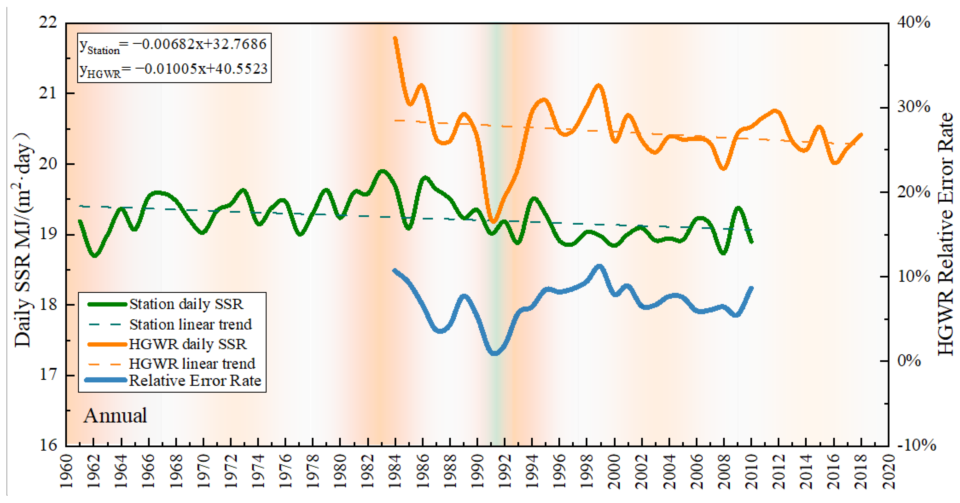
4.3.1. Interannual Variations
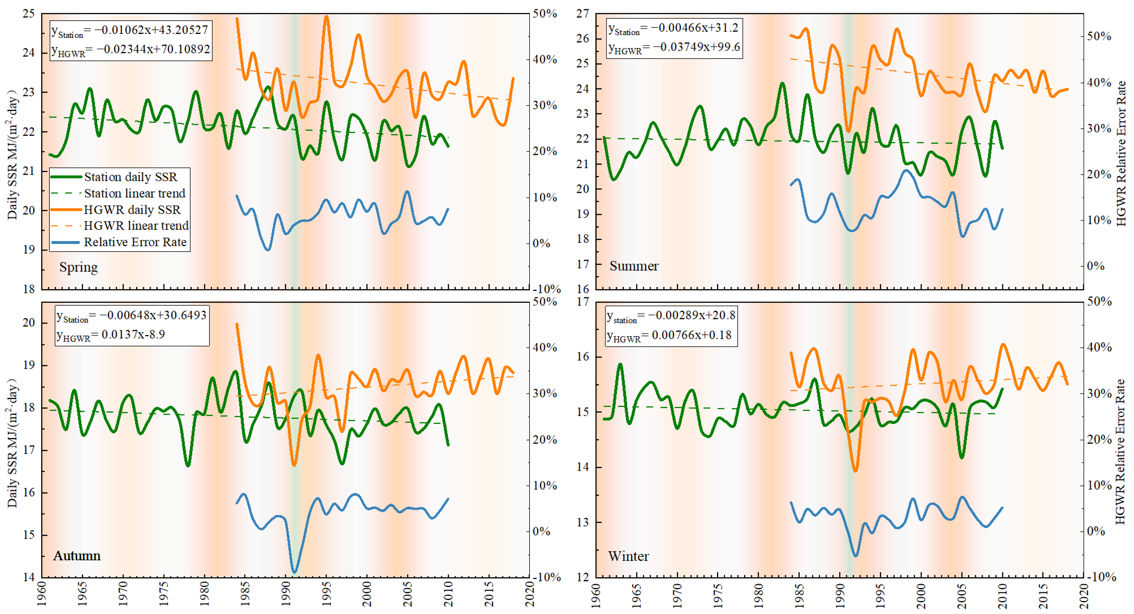
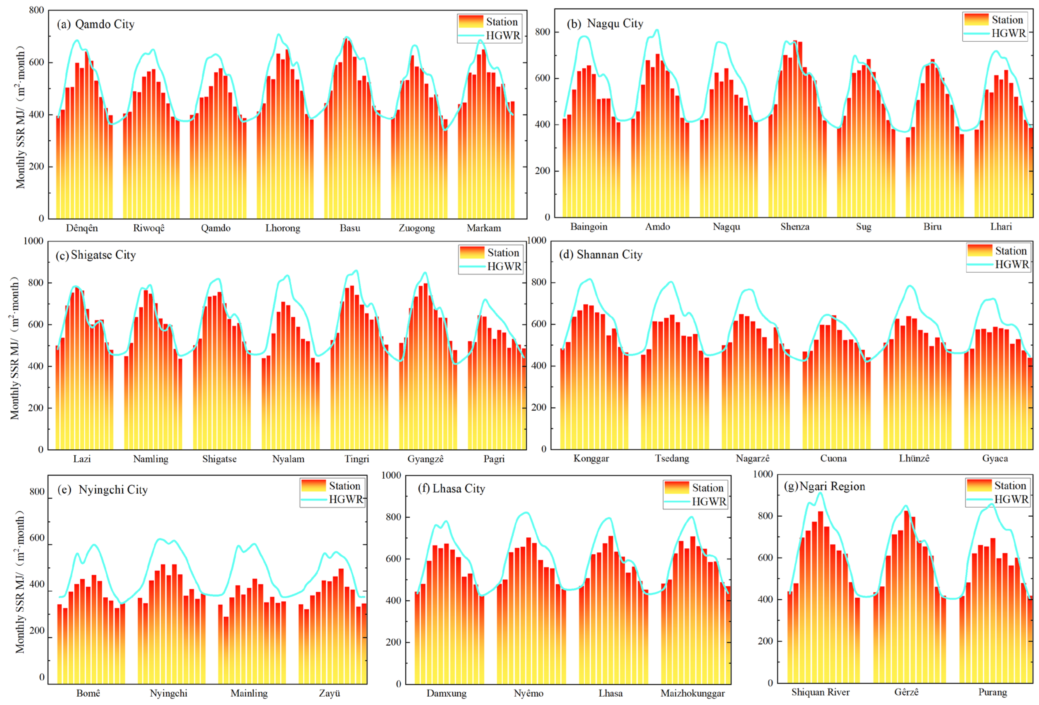
4.3.2. Monthly Variation
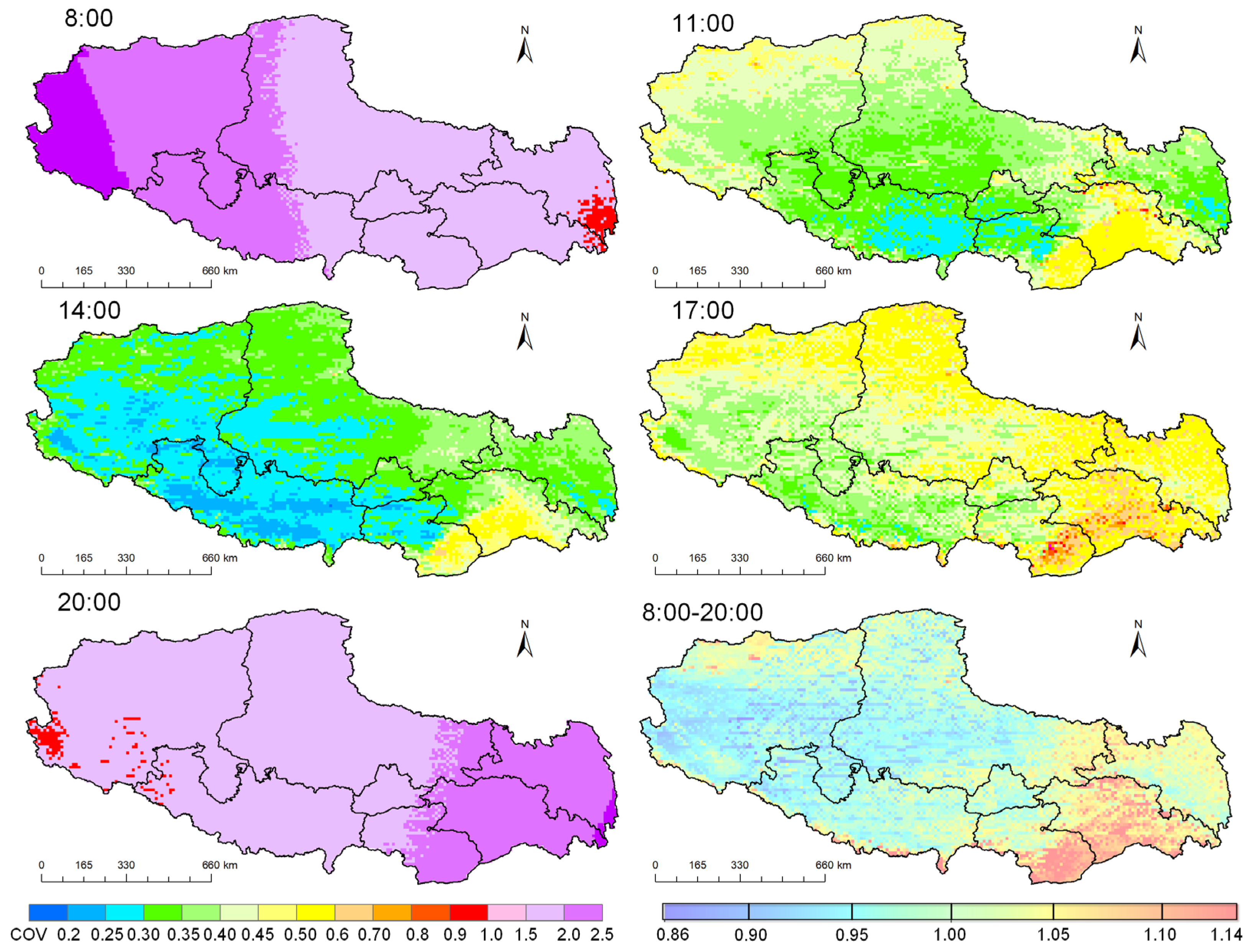
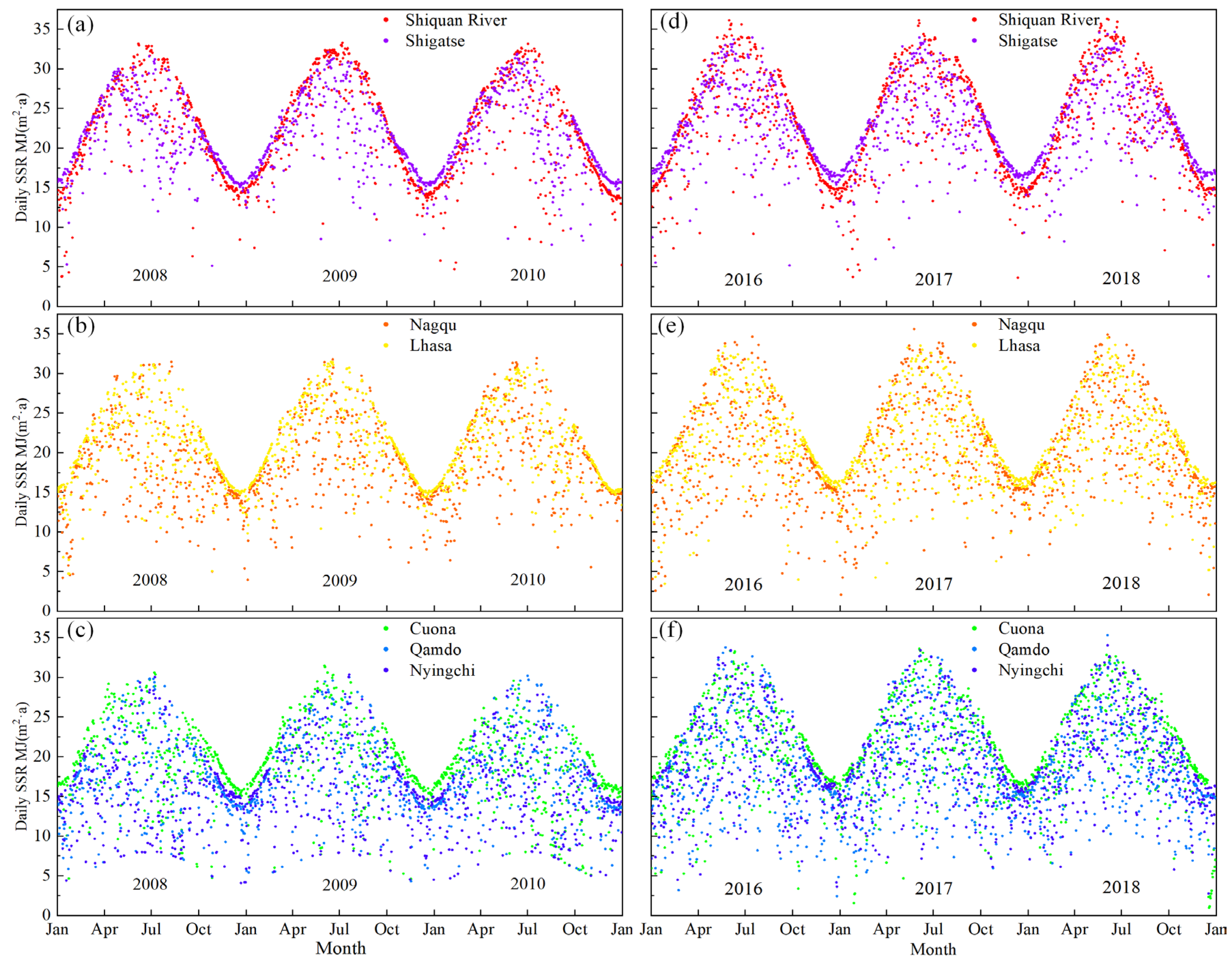
4.3.3. Daily Variation
4.4. Analysis of Resource Assessment at the Regional Level in Xizang
5. Discussion
6. Conclusions
Author Contributions
Funding
Data Availability Statement
Acknowledgments
Conflicts of Interest
Appendix A

| Region | Region Elevation Range (m) | Average Elevation/Elevation Standard Deviation (m) | Station | Coordinates | Elevation (m) |
|---|---|---|---|---|---|
| Ngari | 2596 to 7688 | 4460/520 | Gêrzê | [84.416667, 32.15] | 4416.1 |
| Purang | [81.25, 30.283333] | 3901.2 | |||
| Shiquan River | [80.083333, 32.5] | 4279.8 | |||
| Qamdo | 2016 to 6800 | 3627/1328 | Markam | [98.6, 29.683333] | 3871.2 |
| Zuogong | [97.833333, 29.666667] | 3781.2 | |||
| Qamdo | [97.166667, 31.15] | 3316.2 | |||
| Basu | [96.916667, 30.05] | 3261 | |||
| Riwoqê | [96.6, 31.216667] | 3811.2 | |||
| Lhorong | [95.833333, 30.75] | 3641.2 | |||
| Dênqên | [95.6, 31.416667] | 3874.3 | |||
| Lhasa | 3437 to 7124 | 4824/508 | Maizhokunggar | [91.733333, 29.85] | 3805.1 |
| Damxung | [91.1, 30.483333] | 4201.2 | |||
| Lhasa | [91.133333, 29.666667] | 3650.1 | |||
| Nyêmo | [90.166667, 29.433333] | 3810.6 | |||
| Nyingchi | −304 to 7427 | 3627/1328 | Zayü | [97.466667, 28.65] | 2328.8 |
| Bomê | [95.766667, 29.866667] | 2737.2 | |||
| Nyingchi | [94.333333, 29.666667] | 2993 | |||
| Mainling | [94.216667, 29.216667] | 2951.2 | |||
| Nagqu | 3038 to 6934 | 3662/1603 | Sug | [93.783333, 31.883333] | 4024 |
| Biru | [93.783333, 31.483333] | 3941.2 | |||
| Lhari | [93.283333, 30.666667] | 4490 | |||
| Nagqu | [92.066667, 31.483333] | 4508.2 | |||
| Amdo | [91.1, 32.35] | 4801.2 | |||
| Baingoin | [90.016667, 31.383333] | 4701.2 | |||
| Shenza | [88.633333, 30.95] | 4673.2 | |||
| Shigatse | 662 to 8824 | 4980/480 | Gyangzê | [89.6, 28.916667] | 4041.2 |
| Namling | [89.1, 29.683333] | 4001.3 | |||
| Pagri | [89.083333, 27.733333] | 4301.2 | |||
| Shigatse | [88.883333, 29.25] | 3837.2 | |||
| Lazi | [87.6, 29.083333] | 4001.2 | |||
| Tingri | [87.083333, 28.633333] | 4301.2 | |||
| Nyalam | [85.966667, 28.183333] | 3811.2 | |||
| Shannan | 5 to 7499 | 3662/1603 | Gyaca | [92.583333, 29.15] | 3261.2 |
| Lhünzê | [92.466667, 28.416667] | 3861 | |||
| Cuona | [91.95, 27.983333] | 4281.3 | |||
| Tsedang | [91.766667, 29.266667] | 3561.5 | |||
| Konggar | [90.983333, 29.3] | 3556.5 | |||
| Nagarzê | [90.4, 28.966667] | 4433.7 |

References
- Zhang, X.; Liang, S.; Wang, G.; Yao, Y.; Jiang, B.; Cheng, J. Evaluation of the reanalysis surface incident shortwave radiation products from NCEP, ECMWF, GSFC, and JMA using satellite and surface observations. Remote Sens. 2016, 8, 225. [Google Scholar] [CrossRef]
- Besharat, F.; Dehghan, A.A.; Faghih, A.R. Empirical models for estimating global solar radiation: A review and case study. Renew. Sustain. Energy Rev. 2013, 21, 798–821. [Google Scholar] [CrossRef]
- Duzen, H.; Aydin, H. Sunshine-based estimation of global solar radiation on horizontal surface at Lake Van region (Turkey). Energy Convers. Manag. 2012, 58, 35–46. [Google Scholar] [CrossRef]
- Teke, A.; Yildirim, H.B.; Celik, O. Evaluation and performance comparison of different models for the estimation of solar radiation. Renew. Sustain. Energy Rev. 2015, 50, 1097–1107. [Google Scholar] [CrossRef]
- Li, R.; Zhao, L.; Wu, T.; Ding, Y.; Xin, Y.; Zou, D.; Xiao, Y.; Jiao, Y.; Qin, Y.; Sun, L. Temporal and spatial variations of global solar radiation over the Qinghai–Tibetan Plateau during the past 40 years. Theor. Appl. Climatol. 2013, 113, 573–583. [Google Scholar] [CrossRef]
- Song, Z.; Cao, S.; Yang, H. Assessment of solar radiation resource and photovoltaic power potential across China based on optimized interpretable machine learning model and GIS-based approaches. Appl. Energy 2023, 339, 121005. [Google Scholar] [CrossRef]
- Li, P.; Gao, X.; Jiang, J.; Yang, L.; Li, Y. Spatial and temporal patterns of solar radiation in China from 1957 to 2016. Sci. Cold Arid Reg. 2022, 14, 68–78. [Google Scholar]
- Yang, X.; Qin, W.; Wang, L.; Zhang, M.; Niu, Z. Long-term variations of surface solar radiation in China from routine meteorological observations. Atmos. Res. 2021, 260, 105715. [Google Scholar] [CrossRef]
- Pan, T.; Wu, S.; Dai, E.; Liu, Y. Estimating the daily global solar radiation spatial distribution from diurnal temperature ranges over the Tibetan Plateau in China. Appl. Energy 2013, 107, 384–393. [Google Scholar] [CrossRef]
- Tang, P.; Xu, B.; Tian, D.; Ren, J.; Li, Z. Temporal and spatial variations of meteorological elements and reference crop evapotranspiration in Alpine regions of Tibet, China. Environ. Sci. Pollut. Res. 2021, 28, 36076–36091. [Google Scholar] [CrossRef]
- Zhang, J.; Zhao, L.; Deng, S.; Xu, W.; Zhang, Y. A critical review of the models used to estimate solar radiation. Renew. Sustain. Energy Rev. 2017, 70, 314–329. [Google Scholar] [CrossRef]
- Jin, H.; Wang, S.; Yan, P.; Qiao, L.; Sun, L.; Zhang, L. Spatial and temporal characteristics of surface solar radiation in China and its influencing factors. Front. Environ. Sci. 2022, 10, 916748. [Google Scholar] [CrossRef]
- Yu, L.; Zhang, M.; Wang, L.; Qin, W.; Jiang, D.; Li, J. Variability of surface solar radiation under clear skies over Qinghai-Tibet Plateau: Role of aerosols and water vapor. Atmos. Environ. 2022, 287, 119286. [Google Scholar] [CrossRef]
- Li, Z.; Moreau, L.; Arking, A. On solar energy disposition: A perspective from observation and modeling. Bull. Am. Meteorol. Soc. 1997, 78, 53–70. [Google Scholar] [CrossRef]
- Gui, S.; Liang, S.; Li, L. Evaluation of satellite-estimated surface longwave radiation using ground-based observations. J. Geophys. Res. 2010, 115, D18. [Google Scholar] [CrossRef]
- Zhang, T.; Stackhouse, P.W., Jr.; Gupta, S.K.; Cox, S.J.; Mikovitz, J.C. The validation of the GEWEX SRB surface longwave flux data products using BSRN measurements. J. Quant. Spectrosc. Radiat. Transf. 2015, 150, 134–147. [Google Scholar] [CrossRef]
- Alexandri, G.; Georgoulias, A.K.; Meleti, C.; Balis, D.; Kourtidis, K.A.; Sanchez-Lorenzo, A.; Trentmann, J.; Zanis, P. A high resolution satellite view of surface solar radiation over the climatically sensitive region of Eastern Mediterranean. Atmos. Res. 2017, 188, 107–121. [Google Scholar] [CrossRef]
- Qin, J.; Yang, K.; Liang, S.; Zhang, H.; Ma, Y.; Guo, X.; Chen, Z. Evaluation of surface albedo from GEWEX-SRB and ISCCP-FD data against validated MODIS product over the Tibetan Plateau. J. Geophys. Res. Atmos. 2011, 116, D24. [Google Scholar] [CrossRef]
- Smith, G.L.; Priestley, K.J.; Loeb, N.G.; Wielicki, B.A.; Charlock, T.P.; Minnis, P.; Doelling, D.R.; Rutan, D.A. Clouds and Earth Radiant Energy System (CERES), a review: Past, present and future. Adv. Space Res. 2011, 48, 254–263. [Google Scholar] [CrossRef]
- Zhang, X.; Liang, S.; Wild, M.; Jiang, B. Analysis of surface incident shortwave radiation from four satellite products. Remote Sens. Environ. 2015, 165, 186–202. [Google Scholar] [CrossRef]
- Feng, F.; Wang, K. Merging high-resolution satellite surface radiation data with meteorological sunshine duration observations over China from 1983 to 2017. Remote Sens. 2021, 13, 602. [Google Scholar] [CrossRef]
- Rossow, W.B.; Knapp, K.R.; Young, A.H. International satellite cloud climatology project: Extending the record. J. Clim. 2022, 35, 141–158. [Google Scholar]
- Young, A.H.; Knapp, K.R.; Inamdar, A.; Hankins, W.; Rossow, W.B. The international satellite cloud climatology project H-Series climate data record product. Earth Syst. Sci. Data 2018, 10, 583–593. [Google Scholar] [CrossRef]
- Vafaeipour, M.; Zolfani, S.H.; Varzandeh, M.H.M.; Derakhti, A.; Eshkalag, M.K. Assessment of regions priority for implementation of solar projects in Iran: New application of a hybrid multi-criteria decision making approach. Energy Convers. Manag. 2014, 86, 653–663. [Google Scholar] [CrossRef]
- Gunderson, I.; Goyette, S.; Gago-Silva, A.; Quiquerez, L.; Lehmann, A. Climate and land-use change impacts on potential solar photovoltaic power generation in the Black Sea region. Environ. Sci. Policy 2015, 46, 70–81. [Google Scholar] [CrossRef]
- Mahtta, R.; Joshi, P.K.; Jindal, A.K. Solar power potential mapping in India using remote sensing inputs and environmental parameters. Renew. Energy 2014, 71, 255–262. [Google Scholar] [CrossRef]
- Zhang, Y.; Ren, J.; Pu, Y.; Wang, P. Solar energy potential assessment: A framework to integrate geographic, technological, and economic indices for a potential analysis. Renew. Energy 2020, 149, 577–586. [Google Scholar] [CrossRef]
- Yu, S.; Han, R.; Zhang, J. Reassessment of the potential for centralized and distributed photovoltaic power generation in China: On a prefecture-level city scale. Energy 2023, 262, 125436. [Google Scholar] [CrossRef]
- Jia, A.; Jiang, B.; Liang, S.; Zhang, X.; Ma, H. Validation and spatiotemporal analysis of CERES surface net radiation product. Remote Sens. 2016, 8, 90. [Google Scholar] [CrossRef]
- Tang, W.; Yang, K.; Qin, J.; Min, M. Development of a 50-year daily surface solar radiation dataset over China. Sci. China Earth Sci. 2013, 56, 1555–1565. [Google Scholar] [CrossRef]
- Angstrom, A. Solar and terrestrial radiation. Report to the international commission for solar research on actinometric investigations of solar and atmospheric radiation. Q. J. R. Meteorol. Soc. 1924, 50, 121–126. [Google Scholar] [CrossRef]
- Tang, W.-J.; Yang, K.; Qin, J.; Cheng, C.; He, J. Solar radiation trend across China in recent decades: A revisit with quality-controlled data. Atmos. Chem. Phys. 2011, 11, 393–406. [Google Scholar] [CrossRef]
- Tang, W.; Yang, K.; Qin, J.; Li, X.; Niu, X. A 16-year dataset (2000–2015) of high-resolution (3 h, 10 km) global surface solar radiation. Earth Syst. Sci. Data 2019, 11, 1905–1915. [Google Scholar] [CrossRef]
- Hersbach, H.; Bell, B.; Berrisford, P.; Hirahara, S.; Horányi, A.; Muñoz-Sabater, J.; Nicolas, J.; Peubey, C.; Radu, R.; Schepers, D. The ERA5 global reanalysis. Q. J. R. Meteorol. Soc. 2020, 146, 1999–2049. [Google Scholar] [CrossRef]
- Savtchenko, A.; Ouzounov, D.; Ahmad, S.; Acker, J.; Leptoukh, G.; Koziana, J.; Nickless, D. Terra and Aqua MODIS products available from NASA GES DAAC. Adv. Space Res. 2004, 34, 710–714. [Google Scholar] [CrossRef]
- Prăvălie, R.; Patriche, C.; Bandoc, G. Spatial assessment of solar energy potential at global scale. A geographical approach. J. Clean. Prod. 2019, 209, 692–721. [Google Scholar] [CrossRef]
- Günen, M.A. Determination of the suitable sites for constructing solar photovoltaic (PV) power plants in Kayseri, Turkey using GIS-based ranking and AHP methods. Environ. Sci. Pollut. Res. 2021, 28, 57232–57247. [Google Scholar] [CrossRef]
- Wu, F.; Fu, C. Assessment of GEWEX/SRB version 3.0 monthly global radiation dataset over China. Meteorol. Atmos. Phys. 2011, 112, 155–166. [Google Scholar] [CrossRef]
- Xia, X.A.; Wang, P.C.; Chen, H.B.; Liang, F. Analysis of downwelling surface solar radiation in China from National Centers for Environmental Prediction reanalysis, satellite estimates, and surface observations. J. Geophys. Res. Atmos. 2006, 111, D9. [Google Scholar] [CrossRef]
- Yang, K.; Koike, T.; Stackhouse, P.; Mikovitz, C.; Cox, S.J. An assessment of satellite surface radiation products for highlands with Tibet instrumental data. Geophys. Res. Lett. 2006, 33, L22403. [Google Scholar] [CrossRef]
- Yang, K.; Pinker, R.T.; Ma, Y.; Koike, T.; Wonsick, M.M.; Cox, S.J.; Zhang, Y.; Stackhouse, P. Evaluation of satellite estimates of downward shortwave radiation over the Tibetan Plateau. J. Geophys. Res. Atmos. 2008, 113, D17. [Google Scholar] [CrossRef]
- Zhang, X.; Lv, N.; Yao, L.; Jiang, H. Error analysis of ECMWF surface solar radiation data in China. J. Geo Inf. Sci 2018, 20, 254–267. [Google Scholar]
- Ma, Q.; Wang, K.; Wild, M. Impact of geolocations of validation data on the evaluation of surface incident shortwave radiation from Earth System Models. J. Geophys. Res. Atmos. 2015, 120, 6825–6844. [Google Scholar] [CrossRef]
- Huang, G.; Li, Z.; Li, X.; Liang, S.; Yang, K.; Wang, D.; Zhang, Y. Estimating surface solar irradiance from satellites: Past, present, and future perspectives. Remote Sens. Environ. 2019, 233, 111371. [Google Scholar] [CrossRef]
- Zhang, J.; Shen, R.; Shi, C.; Bai, L.; Liu, J.; Sun, S. Evaluation and comparison of downward solar radiation from new generation atmospheric reanalysis ERA5 across mainland China. J. Geo Inf. Sci. 2021, 23, 2261–2274. [Google Scholar]
- Pfeifroth, U.; Sanchez-Lorenzo, A.; Manara, V.; Trentmann, J.; Hollmann, R. Trends and Variability of Surface Solar Radiation in Europe Based On Surface- and Satellite-Based Data Records. J. Geophys. Res. Atmos. 2018, 123, 1735–1754. [Google Scholar] [CrossRef]
- Sanchez-Lorenzo, A.; Enriquez-Alonso, A.; Wild, M.; Trentmann, J.; Vicente-Serrano, S.M.; Sanchez-Romero, A.; Posselt, R.; Hakuba, M.Z. Trends in downward surface solar radiation from satellites and ground observations over Europe during 1983–2010. Remote Sens. Environ. 2017, 189, 108–117. [Google Scholar] [CrossRef]
- Li, B.; Yang, L.; Tang, S. Intraseasonal variations of summer convection over the Tibetan Plateau revealed by geostationary satellite FY-2E in 2010–2014. J. Meteorol. Res. 2019, 33, 478–490. [Google Scholar] [CrossRef]
- Li, T.; Xin, X.; Zhang, H.; Yu, S.; Li, L.; Ye, Z.; Liu, Q.; Cai, H. Evaluation of Six Data Products of Surface Downward Shortwave Radiation in Tibetan Plateau Region. Remote Sens. 2024, 16, 791. [Google Scholar] [CrossRef]
- Ren, L.; Lin, Z.; Yongjian, D. Variation characteristics of global radiation over the Tibetan Plateau during the past 40 years. J. Glaciol. Geocryol. 2012, 34, 1319–1327. [Google Scholar]
- Kan, A.; Zeng, Y.; Meng, X.; Wang, D.; Xina, J.; Yang, X.; Tesren, L. The linkage between renewable energy potential and sustainable development: Understanding solar energy variability and photovoltaic power potential in Tibet, China. Sustain. Energy Technol. Assess. 2021, 48, 101551. [Google Scholar] [CrossRef]


| Annual SSR | Resource Level |
|---|---|
| ≥2222 kW·h/(m2·a) ≥8000 MJ/(m2·a) | Richest-A |
| 2083–2222 kW·h/(m2·a) 7500–8000 MJ/(m2·a) | Richest-B |
| 1944–2083 kW·h/(m2·a) 7000–7500 MJ/(m2·a) | Richest-C |
| 1750–1944 kW·h/(m2·a) 6300–7000 MJ/(m2·a) | Richest-D |
| 1400–1750 kW·h/(m2·a) 5040–6300 MJ/(m2·a) | Very Rich |
| 1050–1400 kW·h/(m2·a) 3780–5040 MJ/(m2·a) | Rich |
| <1050 kW·h/(m2·a) <3780 MJ/(m2·a) | General |
| Grading Threshold | Stability Level |
|---|---|
| GHRS ≥ 0.58 | Most Stable |
| 0.47 ≤ GHRS < 0.58 | Very Stable |
| 0.36 ≤ GHRS < 0.47 | Stable |
| 0.28 ≤ GHRS < 0.36 | General |
| GHRS < 0.28 | Unstable |
| Month | HGWR_MBE MJ/(m2·Month) | HGWR_RMSE MJ/(m2·Month) | HGWR Relative Error Rate (%) | HRG_MBE MJ/(m2·Month) | HRG_RMSE MJ/(m2·Month) | HRG Relative Error Rate (%) |
|---|---|---|---|---|---|---|
| Jan | 3.85 | 22.9 | 3.8 | 21.9 | 35.2 | 5.4 |
| Feb | 7.5 | 28.1 | 4.7 | 7.2 | 26.1 | 4.2 |
| Mar | 26.2 | 39.4 | 5.7 | 14.5 | 44.7 | 5.3 |
| Apr | 28.9 | 42.9 | 5.5 | 47 | 77.8 | 7.7 |
| May | 30.8 | 57.1 | 6.8 | 86.4 | 110.9 | 12.1 |
| Jun | 21.5 | 62.3 | 6.5 | 84.5 | 113.8 | 12.3 |
| Jul | 3.91 | 51.6 | 5.9 | 63.7 | 95.8 | 10.3 |
| Aug | 38.1 | 74.2 | 9.7 | 118 | 140.3 | 21.5 |
| Sep | 15.8 | 43.9 | 6.4 | 64.4 | 85 | 12.3 |
| Oct | 6.2 | 34.4 | 4.9 | 24.8 | 47.2 | 6.9 |
| Nov | −0.62 | 18.2 | 3.0 | 17.5 | 28.4 | 4.6 |
| Dec | 3.31 | 18.8 | 3.3 | 32.1 | 39.3 | 7.7 |
| Elevation (m) | Mean SSR | One-QTRs SSR | Three-QTRs | Minimum | Maximum |
|---|---|---|---|---|---|
| <2000 | 4464 | 4260 | 4634 | 3724 | 5166 |
| 2000–3000 | 4843 | 4425 | 5169 | 3814 | 6227 |
| 3000–3500 | 6037 | 5211 | 6638 | 3847 | 8263 |
| 3500–4000 | 6364 | 5681 | 6930 | 4008 | 8310 |
| 4000–4500 | 6917 | 6340 | 7687 | 4563 | 8348 |
| 4500–5000 | 7301 | 6962 | 7699 | 5860 | 8367 |
| 5000–5500 | 7276 | 6967 | 7609 | 6026 | 8492 |
| 5500–6000 | 7502 | 7232 | 7819 | 6405 | 8250 |
| >6000 | 7375 | 7089 | 7748 | 6143 | 8234 |
Disclaimer/Publisher’s Note: The statements, opinions and data contained in all publications are solely those of the individual author(s) and contributor(s) and not of MDPI and/or the editor(s). MDPI and/or the editor(s) disclaim responsibility for any injury to people or property resulting from any ideas, methods, instructions or products referred to in the content. |
© 2024 by the authors. Licensee MDPI, Basel, Switzerland. This article is an open access article distributed under the terms and conditions of the Creative Commons Attribution (CC BY) license (https://creativecommons.org/licenses/by/4.0/).
Share and Cite
Kong, H.; Wang, J.; Cai, L.; Cao, J.; Zhou, M.; Fan, Y. Surface Solar Radiation Resource Evaluation of Xizang Region Based on Station Observation and High-Resolution Satellite Dataset. Remote Sens. 2024, 16, 1405. https://doi.org/10.3390/rs16081405
Kong H, Wang J, Cai L, Cao J, Zhou M, Fan Y. Surface Solar Radiation Resource Evaluation of Xizang Region Based on Station Observation and High-Resolution Satellite Dataset. Remote Sensing. 2024; 16(8):1405. https://doi.org/10.3390/rs16081405
Chicago/Turabian StyleKong, Huangjie, Jianguo Wang, Li Cai, Jinxin Cao, Mi Zhou, and Yadong Fan. 2024. "Surface Solar Radiation Resource Evaluation of Xizang Region Based on Station Observation and High-Resolution Satellite Dataset" Remote Sensing 16, no. 8: 1405. https://doi.org/10.3390/rs16081405