Article

Assessing Stone Material Recession of Cultural Heritage: New Approach Based on Satellite-Based Rainfall Data and Dose-Response Functions—Case of UNESCO Site of Matera

1
Dipartimento per l’Innovazione Umanistica, Scientifica e Sociale (DIUSS), Università degli Studi della Basilicata, Via Lanera, 20, 75100 Matera, Italy
2
Istituto di Scienze per il Patrimonio Culturale, Consiglio Nazionale delle Ricerche, C.da S. Loja, sn., 85050 Tito Scalo, Italy
*
Author to whom correspondence should be addressed.
Remote Sens. 2025, 17(8), 1443; https://doi.org/10.3390/rs17081443
Submission received: 6 March 2025 / Revised: 6 April 2025 / Accepted: 16 April 2025 / Published: 17 April 2025
(This article belongs to the Section Environmental Remote Sensing)

Abstract

:
The deterioration of stone materials due to atmospheric factors is a growing global concern, affecting the integrity and preservation of numerous UNESCO World Heritage Sites around the world. This study provides an estimate of the long-term impact of the climate on the degradation of carbonate stone materials in the UNESCO site of Matera, in southern Italy. Focusing on Gravina calcarenite, a lithotype susceptible to weathering, the research integrates satellite-derived precipitation data from the Climate Hazards Group InfraRed Precipitation with Station data (CHIRPS) with a dose-response model. The method involves the calibration of CHIRPS precipitation records against ground-based meteorological data, and the use of year-specific recession coefficients Ky dynamically computed as a function of atmospheric CO2 concentration and temperature. These coefficients were applied within a Lipfert-based equation to estimate annual surface recession from 1981 to 2040 (near future). The results reveal a continuous increase in surface degradation over time, with the cumulative material loss reaching approximately 0.75 mm by 2040. These findings underscore the relevance of climate-responsive models in estimating stone decay and provide a critical basis for adaptive conservation planning. Incorporating future climate projections into risk assessments is essential for the sustainable preservation of carbonate-based cultural heritage exposed to atmospheric and hydrological stressors.

Graphical Abstract

1. Introduction

Managing historic areas requires holistic approaches that integrate all elements as integral components of the urban environment. The 2030 Agenda for Sustainable Development underscores the importance of preserving cultural and natural heritage as part of the commitment to creating inclusive, safe, resilient, and sustainable cities (SDG 11). In this context, assessing environmental risk factors is crucial for heritage conservation, as it helps identify vulnerable monuments and prioritize maintenance efforts to prevent deterioration [1,2,3,4,5].
The degradation of stone materials in cultural heritage due to climate change is a pressing issue that has garnered increasing attention in recent years. Stone materials, extensively used in historic buildings and monuments, are highly vulnerable to environmental factors exacerbated by climate change. Significant challenges include water infiltration, acid rain, crystallization and dissolution of salts driven by wetting and drying cycles, as well as thermal stress resulting from rapid temperature fluctuations [6,7,8,9]. The literature indicates that decay processes are not isolated; they often interact, leading to complex degradation patterns that can severely compromise the structural and aesthetic qualities of heritage sites [1,4,10]. Samuels and Platts [11] provide a comprehensive overview of the risks posed to UNESCO World Heritage Sites, emphasizing the need for robust monitoring and reporting systems to track these changes. In this context, climate change not only threatens the physical structures but also the cultural significance, the management, and the policy associated with them [12,13,14].
Extreme events, such as floods and storms, are difficult to predict and are often modelled stochastically, with their probability of occurrence increasing in response to climate change. In contrast, the continuous degradation processes acting on stones can be identified and quantitatively described, allowing for a more precise assessment of their long-term impact. The evaluation of climate change impacts on cultural heritage and the development of future scenarios to establish long-term protection strategies have notably intensified over the past 15 years [10,15,16,17,18]. Recent research efforts have focused on slow degradation processes that critically affect heritage materials, such as surface recession, thermal stress, biological accumulation on architectural surfaces, and metal corrosion. Human-made artifacts and natural formations may undergo alteration and erosion, which manifest as changes in surface topography, material loss, or surface recession [19,20,21,22,23]. By integrating climatology with conservation science, researchers have acquired unique insights into projecting future damage scenarios for outdoor cultural heritage, primarily driven by gradual climate. Environmental factors—such as concentrations of air pollutants, levels of precipitation, and temperature variations—are frequently integrated into damage functions. According to Strlič et al. [24], damage functions are defined as representations of unacceptable changes in cultural heritage caused by various agents of change. Consequently, the mathematical expressions serve as valuable tools for modeling material alterations, allowing for the assessment of both past and future damage. This approach also facilitates the formulation of effective preservation strategies by utilizing climate projections generated through numerical models.
Over the past few decades, numerous studies have applied dose-response functions to assess damage to stone materials in European monuments, with the aim of quantifying the contribution of various processes to overall degradation and estimating the average rate of deterioration over time [17,25,26,27,28,29,30,31].
The most extensive research focuses on marble and limestone, which are materials that are primarily composed of calcium carbonates (or calcium and magnesium) [15,16,18,32,33]. To simulate the alteration processes affecting these carbonate materials under specific environmental conditions, various models and damage functions have been developed. One notable example is the Lipfert equation [34,35,36,37], which estimates the average annual rate of surface recession based on environmental parameters. The Lipfert function is driven by its efficacy in modeling the dissolution process of calcite, the primary component of carbonate rocks, through theoretical relationships that account for the solubility of calcium carbonate (CaCO3) in equilibrium with the concentrations of atmospheric carbon dioxide (CO2). Bonazza et al. (2009) [15] advanced Lipfert’s model by solving the carbonate equilibrium system under variable pCO2, initially using fixed equilibrium constants at 25 °C. This approach predicted increased calcite solubility with rising CO2 levels but overlooked temperature-dependent effects. To address this limitation, temperature-sensitive expressions for all relevant constants were introduced, enabling a coupled CO2–temperature assessment of calcite dissolution. This refinement allowed for risk and damage projections that assess the impact of continuous climate change—rather than isolated extreme events—on the envelopes of historic buildings.
The need for interdisciplinary approaches that integrate environmental science, cultural heritage management, and policy-making is critical to developing effective adaptation strategies [38,39,40,41,42,43].
During the last decades, remote sensing technology has emerged as a pivotal tool in monitoring climate change, particularly through the collection and analysis of weather data. This technology enables researchers to assess environmental conditions, track changes over time, and model future scenarios, thereby providing critical insights into the impacts of climate change on various ecosystems and human activities, such as the following: (i) tracking changes in land cover across various times and scales, including following disaster events [44,45], (ii) supporting tactical operations in forest firefighting with real-time decision-making systems [46,47], (iii) managing agricultural practices that involve strategies for land use [48,49], (iv) managing water and natural resources [50,51,52], (v) assessing and monitoring carbon reserves and their fluctuations [53], (vi) modeling the dynamics of the climate system [54], and (vii) improving climate forecasts and reanalyzing meteorological data [54,55,56,57].
Italy is the country with the highest ratio of UNESCO sites to land area, and in general has a huge cultural heritage built using local or imported stones (e.g., tuffs, marble, limestone, and travertine) and several studies have been conducted on specific cases to investigate degradation phenomena and propose remedies or solutions [58,59,60,61].
This study aims to analyze the resilience of the so-called ‘Sassi di Matera’, UNESCO world heritage sites in the Basilicata region (Italy), to the environmental impacts of climate change by examining the recession rates of Gravina calcarenite, a building stone widely used in the region that is particularly vulnerable to degradation due to factors, such as erosion and dissolution processes. This study uses a multidisciplinary approach based on the use of remotely sensed data to estimate rainfall, calibrated with ground stations located throughout the Matera municipality, to estimate calcarenite recession rates over time using dose-response functions.

2. Materials and Methods
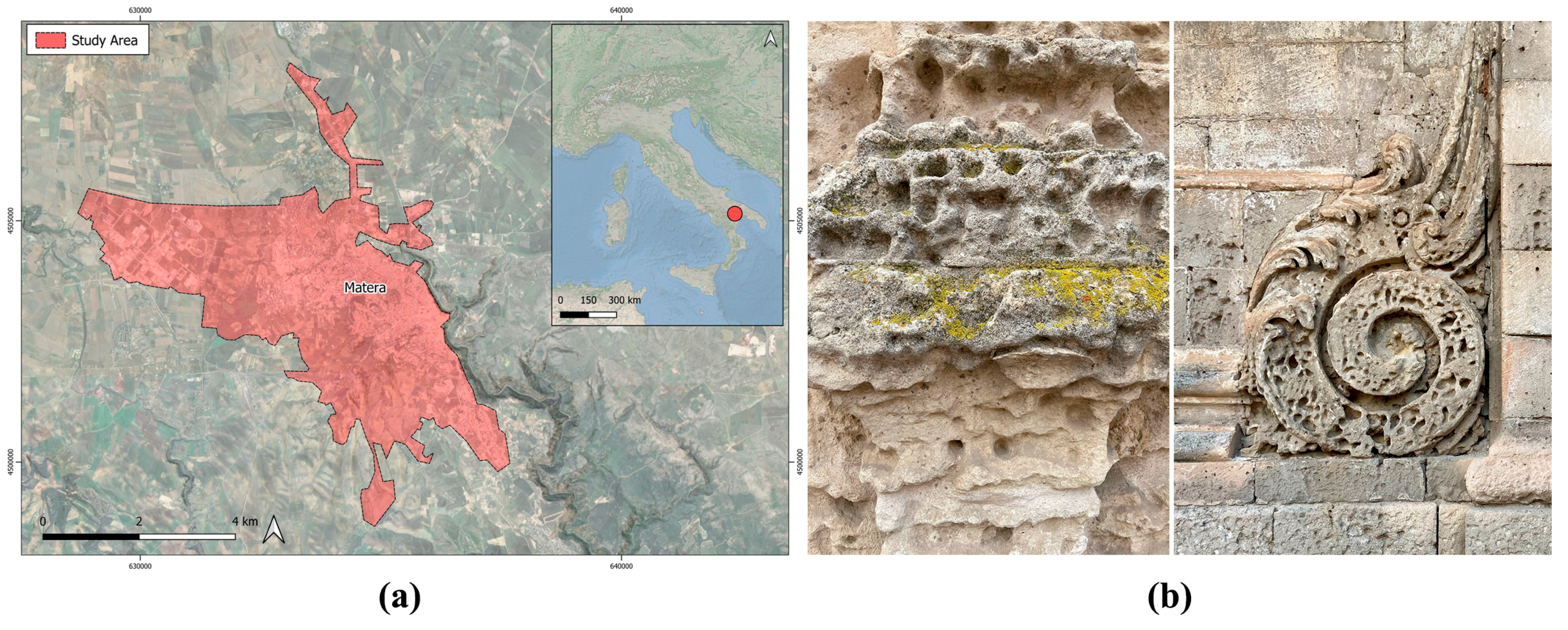
2.1. Study Area

The study area is that of the ‘Sassi di Matera’, in Basilicata (Italy). Matera is renowned for its distinctive rupestrian architecture, which is intricately associated with the local calcarenite (Figure 1). This stone, characterized by high open porosity and low mechanical strength, has been a principal material in constructing the historic districts of Sasso Barisano, Civita, Piano, and Sasso Caveoso. The Gravina calcarenite was extensively described by Iannone and Pieri [62], who conducted lithostratigraphic and sedimentological analyses that identified multiple lithofacies, reflecting the complex physiography of the region.
Further research by Baccelle Scudeler et al. [63] involved a provenance study on the stone used in the Temple of Hera at Metaponto, encompassing samples from ancient quarries across eastern Basilicata and southern Apulia, enriching understanding of the stone’s regional variability. More recently, Bonomo et al. [64,65] conducted comprehensive analyses of calcarenite outcrops in the La Vaglia, Parco Scultura-Paradiso, La Palomba, and Petragallo quarries, offering detailed descriptions of the lithofacies present in these sites. Mineralogical and petrographic characterizations of Gravina calcarenite have shown a predominance of calcite, with minor amounts of quartz and traces of dolomite.
According to the Köppen–Geiger climate classification, further validated for the second half of the 20th century by Kottek et al. [66], the climate of Matera is identified as Csa. This code identifies and describes a Mediterranean climate characterized by hot, dry summers and mild, wet winters. Specifically, the first letter (C) identifies a warm temperate climate, where the average temperature of the coldest month (Tmin) ranges between −3 °C and +18 °C. The second letter (s) indicates a summer season with low or negligible precipitation, while the third letter (a) denotes summers with average maximum temperatures (Tmax) equal to or exceeding +22 °C.
Brimblecombe [67] conducted studies on mechanical and chemical alteration processes across different climate regions, using this classification as a basis to correlate the effects on built structures. These studies highlighted how varying climatic conditions can influence the degradation of construction materials differently, depending on the climatic zone to which they belong. In the Csa climate classification, heritage materials face significant thermal stress due to high insolation, leading to cracking and flaking. However, the dry summer climate can mitigate biological threats like fungi, which thrive in humidity. This duality highlights the need for tailored conservation strategies, ensuring the long-term preservation of cultural heritage in this climate zone.
The Köppen–Geiger classification is fundamentally a thermo-hygrometric system, as it focuses solely on variables like temperature and precipitation. As a result, important climatic parameters—such as relative humidity (beyond its manifestation in precipitation) and wind speed—are excluded from this classification. Additionally, a significant limitation of this system is its failure to account for air pollution, which has profoundly affected urban areas throughout the 20th century. Other overlooked factors include the decrease in salt deposition as the distance from the coast increases. Over time, systematic literature reviews have assessed the state of knowledge on this topic, highlighting the growing recognition of climate-related risks to heritage assets.
Fatorić and Seekamp [68] reviewed studies published up to 2015 and found increasing academic interest, especially in Europe, across diverse disciplines, such as physical sciences, social sciences, and humanities. They stressed the need for future research to include documentation of adaptation efforts to better inform policy.
Orr et al. [69] extended this analysis to literature published from 2016 to 2020, confirming the dominance of European and U.S.-based studies. They emphasized that the interdisciplinary nature of the field contributes to fragmented and hard-to-synthesize literature. Nevertheless, they noted a rising focus on integrating heritage into adaptation and mitigation strategies.
Although both reviews were comprehensive, they did not deeply address the specific impacts of climate stressors. More recently, Sesana et al. (2021) [4] analyzed how climate change affects tangible heritage through material degradation. Their review examined various degradation mechanisms and climate variables, highlighting the complexity of multiple stressors, the effects of gradual climatic changes, and the risks associated with extreme events, such as floods and landslides.
A comprehensive understanding of the conservation status of historic centers is crucial for formulating proactive and targeted intervention strategies, especially for sites of inestimable historical and cultural value, such as the Sassi of Matera. The standardization of decay analysis methodologies has been promoted through international and national commissions, such as ICOMOS, to advance conservation theories, methods, and technologies. Scientific research has further contributed by defining typological classifications of degradation, formalized in regulations like NORMAL 1/88 and UNI 11182:2006, which standardize diagnostic criteria and conservation procedures for stone materials. Over time, studies have combined qualitative observations with quantitative analyses, utilizing degradation indices to assess the intensity and extent of morphological alterations. Notably, Fitzner and Heinrichs [70] developed an objective and reproducible diagnostic method based on a decay index that accounts for both the intensity and spatial distribution of degradation forms.
Within the context of Matera, Gizzi et al. [71] introduced linear and progressive damage indices, based on the intensity and spatial distribution of morphological alterations detected in Gravina calcarenite, with particular attention to the influence of atmospheric agents. Through the integration of field surveys and spatial analyses conducted via Geographic Information Systems (GISs), the study highlighted that north-facing surfaces are more susceptible to erosive action from wind and rain, while south-facing surfaces are mainly affected by direct solar radiation. In the same context, the study by Bonomo et al. [72] further explored the specific degradation patterns of Gravina calcarenite, analyzing a sample of 100 facades within the Sassi. Through the qualitative classification proposed by Bonomo et al., degradation morphologies were examined to assess the extent and spatial distribution of degradation patterns in the two main varieties of calcarenite (bioclastic and lithoclastic). Despite the apparently harmonious landscape carved into the rock, the Sassi conceals significant stone material degradation, attributable to both differential settlements and the combined action of atmospheric and anthropogenic agents. The analyses revealed that alveolization is widespread in both types of calcarenite, with a prevalence observed in 80% of the facades examined. This degradation phenomenon is accompanied by other forms of alteration, such as detachment, which is more pronounced in lithoclastic calcarenite, and peeling, which is often associated with inappropriate restoration interventions, and is particularly evident in bioclastic calcarenite. Fractures occur more frequently in lithoclastic calcarenite, while surface deposits are found in both lithological varieties. Despite these issues, the urban environment of Matera presents pollution levels below legal thresholds, and no significant signs of surface sulfation have been recorded on stone artifacts.

2.2. Analysis of Rainfall Data

2.2.1. Rainfall Dataset

Two types of rainfall data were used for this study: (i) rainfall data obtained using CHIRPS satellite data; and (ii) local rainfall data for the study area thanks to a weather station in La Martella (Matera).
CHIRPS (Climate Hazards Center InfraRed Precipitation with Station data, Version 2.0 Final) is a 30+ year quasi-global rainfall dataset. CHIRPS incorporates 0.05° resolution (5.5 km approx.) satellite imagery with in situ station data to create gridded rainfall time series for trend analysis and seasonal drought monitoring [73]. CHIRPS combines satellite imagery with in situ station data, which improves its accuracy compared to models that rely solely on satellite data. The inclusion of ground station data helps to correct the biases often found in satellite-only products, especially in complex terrains and extreme weather conditions. Several studies have validated CHIRPS against other precipitation datasets and ground observations [74]. Generally, CHIRPS has been found to perform well, particularly in tropical regions where other satellite-based estimates may struggle. It tends to be more accurate in detecting and quantifying moderate to heavy rainfall events. However, as studies have shown, the data may underestimate light rain and drizzle and may be less accurate in regions with few rain gauges contributing to the station data [74,75,76,77,78]. This data was used for the period from 1981 to 2024.
The data from the ARPAB (Agenzia Regionale per la Protezione Ambientale Basilicata, Matera, Italy) weather station located in La Martella, Matera is freely accessible online from https://centrofunzionale.regione.basilicata.it/it/sensoriTempoReale.php?st=P (accessed on 15 March 2025). The ARPAB website provides data from various acquisition stations throughout the Basilicata region in real or near-real time. For the data from the La Martella station, the time period from 2015 to 2024 was taken into consideration, as it was the one available in the ARPAB archives.

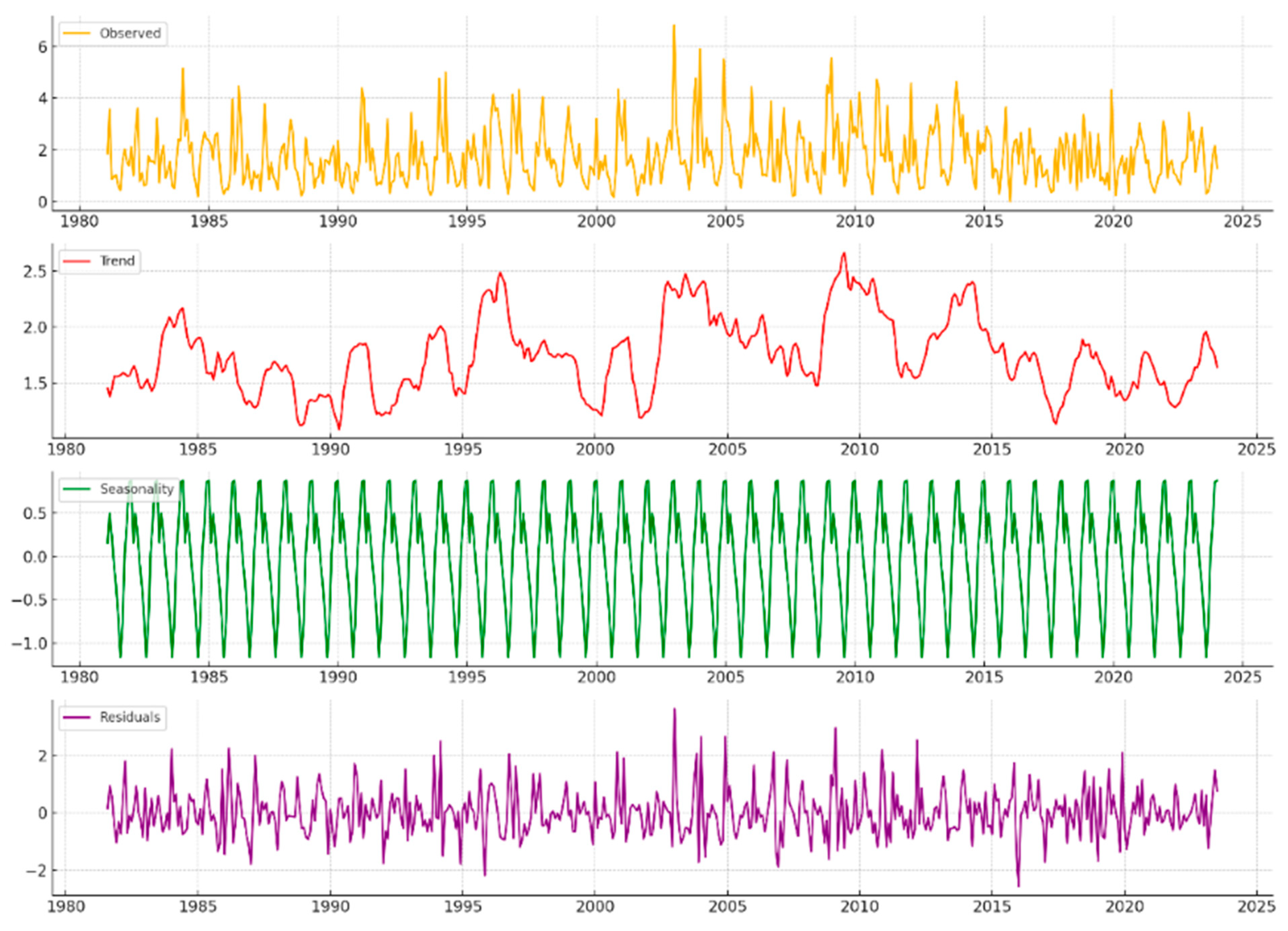
2.2.2. Data Processing

The CHIRPS data were utilized via the Google Earth Engine (GEE) platform, which provides access to large datasets free of charge, using a JavaScript-based front-end interface and exploiting Google’s calculation engines, which are all directly in the cloud [79,80,81,82,83]. The data used considered the period from 1 January 1981 to 1 January 2024 for the Matera city area, with an approximately daily revisit time. The data thus acquired were subsequently analyzed with the aim of the following: (i) understanding the temporal evolution of trends and phenomena over a long period (1981–2024) between years and variations and trends in seasonal averages; and (ii) identifying the occurrence of ‘anomalous’ events, i.e., above the 99th percentile. The temporal evolution of precipitation in the study area was evaluated using a Seasonal and Trend Decomposition using Loess (STL) function. The STL algorithm is a robust technique for decomposing time series that allows the components of a series to be separated into trends, seasonality, and residuals. This method is particularly useful for analyzing time series that show seasonal patterns and trends over the long term, providing a detailed understanding of each component [84,85,86,87]. These components can be described as follows:
  • Trend: Identifies and isolates the long-term trend in the time series, showing the direction and speed of change in the data over time, beyond seasonal or irregular fluctuations.
  • Seasonality: Extracts the seasonal component, which represents regular and predictable variations that occur at specific intervals, such as daily, monthly, yearly, etc.
  • Residual: The residual component includes fluctuations in the data that cannot be explained by either trends or seasonality, offering insight into anomalies or shocks that were not expected.
Extreme events were also extracted from the CHIRPS data obtained, and were considered to be those events with a 99th percentile (Pk) value (1) [88].
P k = X n + 1     k / 100  
where
  • Pk is the k-th percentile you are trying to determine.
  • X is the data ordered from least to greatest.
  • n is the total number of observations in the data.
  • k is the desired percentile (e.g., 90, 95, 99).
Since the recent bibliography has pointed out some possible discrepancies between the CHIRPS data and locally recorded data, the CHIRPS data downloaded from the GEE were correlated with data from a meteorological station located in Matera, loc. La Martella, provided by ARPAB (Agenzia Regionale per la Protezione Ambientale Basilicata) free online [74,75,76,78], in order to be able to estimate its reliability. The rainfall data provided by the La Martella station included the time period from 2015 to 2024. For this reason, a comparison was made over this time period. In order to compare the two datasets and understand any deviation between the two in order to estimate the uncertainty in the use of CHIRPS data, the following steps were taken:
(i)
removal of negative (values attributed by ARPAB stations in the case of corrupted data) and no-data values;
(ii)
creation of monthly averages;
(iii)
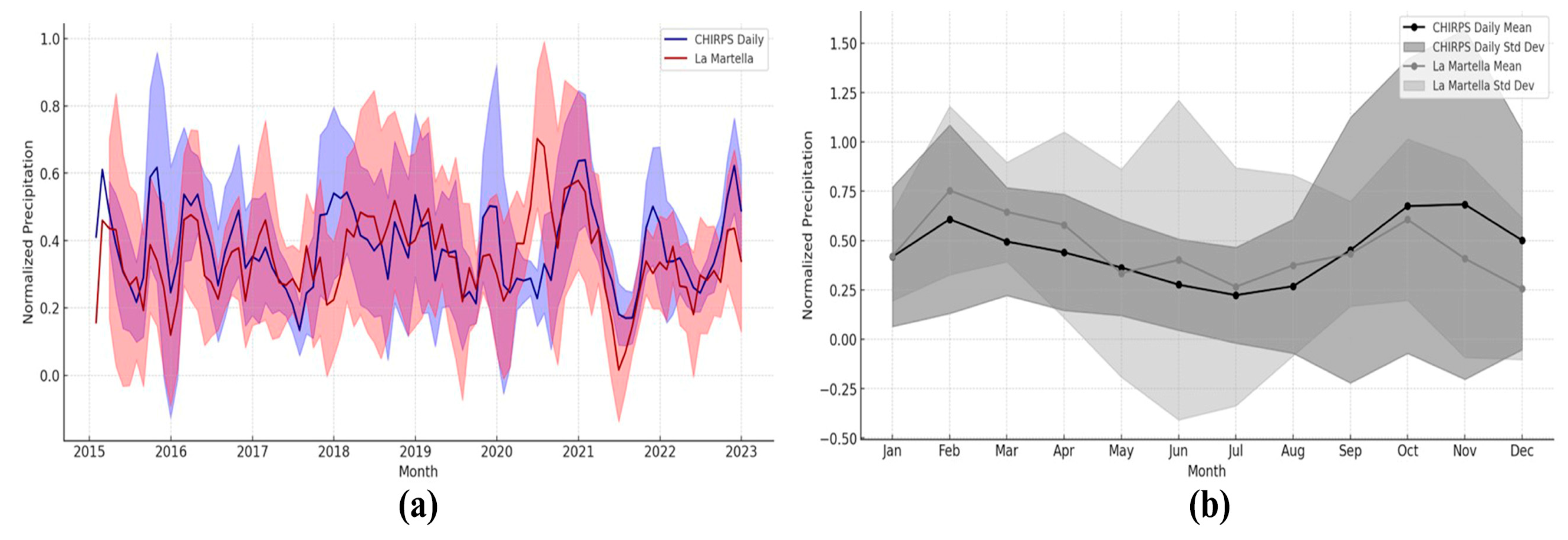
removal of outliers (e.g., under the 10th percentile and above the 99th percentile). This operation was done as a preliminary action prior to the correlation activity. In fact, the removal of extreme events and outliers was useful to avoid considering phenomena recorded only in one of the two datasets (e.g., very local phenomena that occurred at the La Martella weather station) since there is a large spatial acquisition discrepancy between the CHIRPS satellite data and the local ARPAB station data;
(iv)
normalization of the two datasets and application of Pearson’s correlation coefficient [89].
To estimate surface recession up to 2040, the annual value of the CHIRPS data was also projected using a linear regression model (2) fitted to observed historical rainfall data:
γ = β0 + β1 x + ∈
where
  • γ is the dependent variable that we are trying to predict or explain.
  • x is the independent variable used to predict y.
  • β0 is the intercept, i.e., the value of y when x is zero.
  • β1 is the coefficient of the independent variable x, and it represents the slope of the regression line. This coefficient indicates how much y changes on average with a unit increase in x.
  • ∈ is the error term that captures all other influences on γ that are not explained by x.

2.3. Dose-Response Functions

In this study, the equation proposed by Ciantelli et al. [90] was adopted. The equation relates precipitation data to the recession coefficient (K1,2) to estimate the surface erosion of carbonate rocks induced by karst processes as follows (3):
L = K1,2 × R
where
  • L represents the annual surface recession (μm/year),
  • R is the annual amount of precipitation (m/year),
  • K is an empirical coefficient that varies according to the concentration of atmospheric CO2.
Ciantelli et al. [90] focused on two distinct scenarios, each characterized by a different value of the coefficient K:
  • K1 = 18.8 μm/m, corresponding to a CO2 concentration of 330 ppm, used to represent historical conditions;
  • K2 = 21.8 μm/m, relating to a CO2 concentration of 750 ppm, used for future projections, assuming an increase in atmospheric CO2 concentration.
In the present analysis, however, time-varying recession coefficients (Ky) were introduced. These were calculated for each year using the thermodynamic model developed by Bonazza et al. [15], which refines Lipfert’s original methodology by explicitly accounting for the combined effects of atmospheric CO2 concentration and temperature on calcite solubility. In order to calculate the Ky coefficient, the CO2 datasets used were obtained from Meinshausen et al. [91,92], which integrate instrumental records with scenario-based projections from the Shared Socioeconomic Pathways (SSPs). The SSP2-4.5 scenario was selected, representing an intermediate emissions pathway characterized by moderate mitigation efforts and socio-economic continuity. Dynamic Ky values were computed up to the year 2040 (near future), enabling a climate-responsive, process-based estimation of surface recession driven by karst dissolution mechanisms (Figure 2). The year 2040 marks the end of the standard near-future window (2010–2039) commonly used in climate impact studies. This reference aligns with projections from the Hadley Centre Coupled Climate Model (HadCM3) and the Regional Climate Model (HadRM3), supporting analyses of gradual processes, such as carbonate stone recession, and providing a practical horizon for evaluating adaptation strategies before more critical impacts emerge later in the century.
The annual values of L were summed to calculate the cumulative surface recession, representing the total amount of material lost over time. This process was crucial for providing a long-term estimate of the overall erosive impact, highlighting potential structural and aesthetic damage to monuments and architectural structures subjected to adverse atmospheric conditions.

3. Results

3.1. Analysis of Precipitation Trends in Matera

The analysis of daily precipitation in Matera from 1981 to 2024, conducted using the CHIRPS dataset, provides a comprehensive understanding of the rainfall dynamics in this area. The trend of annual precipitation between 1981 and 2024 highlights significant interannual variability:
  • Early 1980s: Annual precipitation levels were moderate, ranging from 500 to 700 mm.
  • 1990s and early 2000s: In these decades, precipitation fluctuated, alternating between particularly rainy years and years with reduced rainfall, without any evident trend of an increase or decrease.
  • Recent years: In recent years, a slight reduction in the average annual precipitation has been noted, although significant variations continue to occur from year to year.
This analysis indicates that precipitation in Matera is characterized by irregular oscillations and intermittent rainfall cycles. The average daily precipitation has been calculated at approximately 1.74 mm/day, but there is considerable dispersion around this mean, with a standard deviation of 4.98 mm/day. This value indicates strong daily variability, highlighted by the fact that 50% of the days report precipitation of 0 mm, underscoring the prevalence of dry days. However, intense precipitation events, defined as those exceeding the 99th percentile (over 23.88 mm/day), were recorded on 157 days during the study period, demonstrating the frequent occurrence of extreme rainfall phenomena. Some of the most significant events include the following (Figure 3):
  • 8 October 1989: 67.06 mm
  • 26 January 1996: 67.04 mm
  • 2 October 2000: 78.25 mm
  • 26 September 2006: 63.78 mm
  • 13 October 2010: 66.76 mm
Figure 3. Daily precipitation by CHIRPS data and calculation of extreme events above 99th percentile.
Remotesensing 17 01443 g003
The decomposition of the precipitation time series has allowed for the division of the data into four main components: the observed data, the trend, the seasonality, and the residuals. The observed component reflects the variable trend of precipitation. The long-term trend, representing the general direction of precipitation over time, shows significant fluctuations: until the 2000s, there was a tendency for increasing precipitation, potentially linked to an increase in atmospheric humidity or changes in global circulation patterns. Subsequently, a phase of decreasing precipitation was observed until 2015, followed by a slight increase in recent years (Figure 4).
The analysis of annual variations confirms these observations: 2009 stands out as the year with the highest precipitation, at 906.88 mm, while 2017 marks the lowest, with 469.56 mm. The seasonal component of the time series reveals a well-defined cyclical pattern, reflecting the pronounced seasonality of precipitation in Matera (Figure 2). This annual cycle is predictable, with peaks occurring at certain times of the year, typically in autumn and spring, which are characterized by abundant rainfall. Autumn emerges as the rainiest season, a common feature in Mediterranean regions where the interaction between cyclonic systems and atmospheric humidity generates heavy rainfall.
The residuals from the decomposition, representing the variability unexplained by the trend or seasonality, indicate the presence of stochastic factors or anomalous events not captured by the other model components. These residuals may be influenced by local variables, such as transient atmospheric phenomena, suggesting the need to consider additional factors or more complex models to fully understand the rainfall dynamics.
The identification of extreme events, defined as days with daily precipitation exceeding the 99th percentile, has allowed for the isolation of days with the heaviest rainfall, providing valuable insights into the potential exposure of the territory to hydrogeological risks. The distribution of these events is not uniform but shows concentrations in certain years, suggesting possible correlations with anomalous climatic episodes or other meteorological events of exceptional intensity. The increase in the frequency and intensity of such events may be an indicator of ongoing climate change [93,94,95,96], with direct implications for risk management and land planning [1,18].
The analysis of the transformed data of the pluviometric series acquired from the satellite data and from the local station La Martella shows a moderate Pearson’s correlation index equal to 0.635 and a root mean square deviation (RMSE) equal to 0.14 (Figure 5).
In order to calculate the dose-response function, as described in 2.3, the estimation was done using CHIRPS values with a 2σ (±0.4) oscillation. The percentage of differences between the two datasets that fall within this acceptance range is 96.81%. This indicates a high level of agreement between the two precipitation datasets, according to the defined 2σ criterion.

3.2. Damage Evaluation and Future Prediction

Carbonate surface recession was estimated over the period 1981–2040 by applying the Lipfert-based Equation (3), using annually resolved Ky coefficients corresponding to atmospheric CO2 concentrations, in accordance with the SSP2-4.5 CO2 scenario. The analysis allowed for the quantification of the observed average annual and cumulative recession rate and the estimation of future recession, highlighting the direct relationship between increasing CO2 concentrations and the rising erosion rate of carbonate materials. The annual recession data for carbonate materials show a consistent trend of degradation well above critical safety thresholds. Specifically, the analysis yielded an annual material recession of 12.46 μm/year, while projections or measurements for 2040 indicate a further increase to 13.16 μm/year. Both values significantly exceed the tolerable limit of 8.0 μm/year defined by de la Fuente et al. (2011) [79] for stone materials. This threshold, established through empirical analyses of real-world corrosion rates and serving as a benchmark for heritage conservation, represents the point beyond which restoration becomes necessary to preserve the artefact’s integrity. Figure 6 illustrates the cumulative surface recession of carbonate substrates over the period 1981–2040. Under the CO2 SSP2-4.5 scenario, up to the year 2024, the curve shows a consistent increase in cumulative surface loss, reaching approximately 0.53 mm. The cumulative surface loss is expected to reach approximately 0.75 mm by 2040. The shaded envelope around the projection denotes the uncertainty associated with the regression-based precipitation forecast (±σ), illustrating the potential sensitivity of the recession rate to future pluviometric variability.
The curve highlights a persistent acceleration in material losses over time, attributable to the enhanced solubility of calcite under increasing atmospheric CO2 and the compound effect of annual precipitation input.
The projections provide information on the long-term surface degradation under mean climatic conditions, translating climate forcing into quantifiable material losses and damage potentials for the local lithological context of the UNESCO site (Figure 6).

4. Discussion

The analysis of surface recession in carbonate substrates provided an estimation of material losses. The analysis of surface recession in carbonate substrates in the Matera area, as presented in Figure 6, builds upon the modified Lipfert Equation (3) to model climate-dependent material losses over the period 1981–2040. This approach captures chemically driven weathering processes by integrating precipitation data and atmospheric CO2 concentrations on a year-by-year basis. The use of CHIRPS-derived rainfall data, combined with time-specific atmospheric forcing, allows for the reconstruction of historical patterns and the projection of near-future surface degradation rates.
The lithology of Matera’s calcarenites—characterized by variable porosity and lithoclastic and bioclastic content—makes them especially susceptible to dissolution even under moderate rainfall. This is consistent with the findings of Salvini et al. [97,98], who documented enhanced surface loss in porous carbonate stones due to intrinsic petrographic features, such as large grain size and interconnected pore networks. Their data suggest that even in the absence of aggressive pollutants, natural weathering under CO2-rich rainfall can lead to progressive surface loss.
The recession rates calculated for Matera fall within a range of approximately 10–17 µm/year. These values are broadly consistent with those reported for medium-porosity carbonate stones across Europe. Bonazza et al. [15] estimated average surface recession rates between 12 and 17 µm/year for Portland limestone under historical climate conditions, using the Lipfert-based approach.
Furthermore, comparisons with in situ measurements—such as the photogrammetric study by Hernández-Montes et al. [99] on historical brick façades in Venice—highlight similar trends in linear material recession over multi-decadal periods, with rates on the order of 10–15 µm/year, despite differences in substrate and exposure.

5. Conclusions

The results of this study offer a predictive tool for conservation planning and, at the same time, provide a comparative reference point for understanding the intensity of local alteration within a broader climatic and lithological framework.
While this study provides insights into the relationship between climate dynamics and stone material degradation, certain limitations should be acknowledged. It would be beneficial to extend the proposed method—originally applied to correlate CHIRPS data with meteorological data from the Matera station (loc. La Martella)—to periods beyond 2015–2024. However, the availability of ground-based meteorological station networks remains limited, both in many regions worldwide and within Italy.
Despite the quantitative robustness of the Lipfert function (3), it is crucial to acknowledge its inherent limitations. The model simplifies the chemical composition of rainwater, which may lead to appreciable deviations from actual conditions, especially in areas subject to complex pollution dynamics This limitation can lead to significant inaccuracies, particularly in environments where atmospheric pollutant levels are highly dynamic due to factors like industrial emissions, vehicular traffic, and seasonal fluctuations. Furthermore, the model tends to underestimate critical factors, such as urban pollution and aerosol deposition, both of which play a pivotal role in accelerating material degradation.
Additionally, the model’s reliance on the assumption of linearity in projecting future environmental trends fails to capture the complex, non-linear dynamics that are intrinsic to climate change. Environmental processes are inherently complex, influenced by shifts triggered by extreme climatic events. This oversimplification risks underestimating the potential impact of various factors, such as the increasing frequency and intensity of extreme weather events—heatwaves, heavy precipitation—as well as rapid changes in atmospheric chemistry. These factors can significantly alter both the rate and mechanisms of material degradation over short timescales, in ways that linear models are ill-equipped to predict. Considering these factors, it is essential to develop and implement robust methods for calibrating data derived from mathematical models against real-world observations. This calibration process entails the systematic collection of data related to environmental conditions, pollutant concentrations, and material response indicators. Such comprehensive data gathering facilitates the identification of patterns, anomalies, and emerging trends that static models may fail to detect. In this context, calibration not only improves predictive accuracy but also enhances the adaptability of the model to different environmental scenarios. Calibration involves fine-tuning model parameters based on empirical observations and case studies, thereby improving the alignment between predicted and actual degradation rates.
Ultimately, this integrated approach supports more informed decision-making for the preservation of materials and structures, particularly in the face of accelerating climate change and growing urbanization pressures. It fosters a proactive conservation paradigm, capable of anticipating rather than merely reacting to environmental threats. It provides a flexible, adaptive framework capable of addressing the complex challenges posed by rapidly changing environmental conditions, thereby contributing to more effective risk assessment, conservation strategies, and policy development. The resulting projections can also be integrated into decision support systems, enabling more timely and targeted interventions. The integration of predictive models—especially those combining machine learning techniques with multivariate statistical approaches—to estimate stone surface recession under varying environmental and material conditions could further strengthen the reliability and responsiveness of conservation strategies, enabling more proactive and scientifically grounded decision-making in heritage preservation.

Author Contributions

Conceptualization, F.V. and N.A.; Data curation, F.V. and N.A.; Formal analysis, F.V. and N.A.; Funding acquisition, N.M.; Investigation, F.V. and N.A.; Methodology, F.V. and N.A.; Project administration, N.M.; Resources, F.V. and N.A.; Software, F.V. and N.A.; Supervision, M.S. and N.M.; Validation, F.V. and N.A.; Visualization, F.V., N.A. and M.S.; Writing—original draft, F.V. and N.A.; Writing—review and editing, F.V. and N.A. All authors have read and agreed to the published version of the manuscript.

Funding

This research received external funding from the Project CHANGES Spoke 5 financed by PNRR (Missione 4 Componente 2, dalla ricerca all’impresa; Linea di Investimento 1.3—Partenariati allargati estesi a università, centri di ricerca, imprese e finanziamento progetti di ricerca di base; finanziato dall’Unione Europea—NextGenerationEU, Piano Nazionale di Ripresa e Resilienza—CUP B53C22003890006).

Data Availability Statement

The original contributions presented in this study are included in the article. Further inquiries can be directed to the corresponding author.

Conflicts of Interest

The authors declare no conflicts of interest. The funders had no role in the design of this study; in the collection, analyses, or interpretation of data; in the writing of the manuscript; or in the decision to publish the results.

References

  1. Bonazza, A.; Sardella, A. Climate Change and Cultural Heritage: Methods and Approaches for Damage and Risk Assessment Addressed to a Practical Application. Heritage 2023, 6, 3578–3589. [Google Scholar] [CrossRef]
  2. Sabbioni, C.; Cassar, M.; Brimblecombe, P.; Tidblad, J.; Kozlowski, R.; Drdácký, M.; Saiz-Jimenez, C.; Grøntoft, T.; Wainwright, I.; Ariño, X. Global Climate Change Impact on Built Heritage and Cultural Landscapes. In Proceedings of the International Conference on Heritage, Weathering and Conservation, HWC 2006, Madrid, Spain, 21–24 June 2006. [Google Scholar]
  3. Richards, J.; Brimblecombe, P. Tuning and Effectiveness in Heritage Models. Heritage 2023, 6, 5516–5523. [Google Scholar] [CrossRef]
  4. Sesana, E.; Gagnon, A.S.; Ciantelli, C.; Cassar, J.; Hughes, J.J. Climate Change Impacts on Cultural Heritage: A Literature Review. WIREs Clim. Change 2021, 12, e710. [Google Scholar] [CrossRef]
  5. Leissner, J.; Kilian, R.; Kotova, L.; Jacob, D.; Mikolajewicz, U.; Broström, T.; Ashley-Smith, J.; Schellen, H.L.; Martens, M.; Van Schijndel, J.; et al. Climate for Culture: Assessing the Impact of Climate Change on the Future Indoor Climate in Historic Buildings Using Simulations. Herit. Sci. 2015, 3, 38. [Google Scholar] [CrossRef]
  6. Haugen, A.; Mattsson, J. Preparations for Climate Change’s Influences on Cultural Heritage. Int. J. Clim. Change Strateg. Manag. 2011, 3, 386–401. [Google Scholar] [CrossRef]
  7. Hart, S.; Raymond, K.; Williams, C.J.; Rutherford, W.A.; DeGayner, J. Modeling Earthen Treatments for Climate Change Effects. Heritage 2023, 6, 4214–4226. [Google Scholar] [CrossRef]
  8. Bretti, G.; Ceseri, M. Climate Change Effects on Carbonation Process: A Scenario-Based Study. Heritage 2023, 6, 236–257. [Google Scholar] [CrossRef]
  9. Thickett, D. Practical Use of Damage Functions for Environmental Preventive Conservation and Sustainability—Examples from Naturally Ventilated Buildings. Heritage 2023, 6, 2633–2649. [Google Scholar] [CrossRef]
  10. Sardella, A.; Palazzi, E.; von Hardenberg, J.; Del Grande, C.; De Nuntiis, P.; Sabbioni, C.; Bonazza, A. Risk Mapping for the Sustainable Protection of Cultural Heritage in Extreme Changing Environments. Atmosphere 2020, 11, 700. [Google Scholar] [CrossRef]
  11. Lafrenz Samuels, K.; Platts, E.J. Global Climate Change and UNESCO World Heritage. Int. J. Cult. Prop. 2022, 29, 409–432. [Google Scholar] [CrossRef]
  12. Dastgerdi, A.S.; Sargolini, M.; Pierantoni, I. Climate Change Challenges to Existing Cultural Heritage Policy. Sustainability 2019, 11, 5227. [Google Scholar] [CrossRef]
  13. Fatorić, S.; Seekamp, E. Securing the Future of Cultural Heritage by Identifying Barriers to and Strategizing Solutions for Preservation under Changing Climate Conditions. Sustainability 2017, 9, 2143. [Google Scholar] [CrossRef]
  14. Sulaj, A.; Kadiu, B.; Terpollari, A. The Need to Safeguard Cultural Heritage against Climate Change. Tech. Ann. 2023, 1, 28–42. [Google Scholar] [CrossRef]
  15. Bonazza, A.; Messina, P.; Sabbioni, C.; Grossi, C.M.; Brimblecombe, P. Mapping the Impact of Climate Change on Surface Recession of Carbonate Buildings in Europe. Sci. Total Environ. 2009, 407, 2039–2050. [Google Scholar] [CrossRef]
  16. Bonazza, A.; Sabbioni, C.; Messina, P.; Guaraldi, C.; De Nuntiis, P. Climate Change Impact: Mapping Thermal Stress on Carrara Marble in Europe. Sci. Total Environ. 2009, 407, 4506–4512. [Google Scholar] [CrossRef]
  17. Brimblecombe, P.; Grossi, C.M.; Harris, I. Climate Change Critical to Cultural Heritage. In Proceedings of the Heritage, Weathering and Conservation; Taylor & Francis Group: Milton Park, UK, 2006; pp. 387–393. [Google Scholar]
  18. Grossi, C.M.; Bonazza, A.; Brimblecombe, P.; Harris, I.; Sabbioni, C. Predicting Twenty-First Century Recession of Architectural Limestone in European Cities. Environ. Geol. 2008, 56, 455–461. [Google Scholar] [CrossRef]
  19. Natali, I.; Tomasin, P.; Becherini, F.; Bernardi, A.; Ciantelli, C.; Favaro, M.; Favoni, O.; Pérez, V.J.F.; Olteanu, I.D.; Sanchez, M.D.R.; et al. Innovative Consolidating Products for Stone Materials: Field Exposure Tests as a Valid Approach for Assessing Durability. Herit. Sci. 2015, 3, 6. [Google Scholar] [CrossRef]
  20. Wang, Y.; Zhang, H. The Synergic Impacts of Salt Mixture and Frost Damage on Rock Decay: Implications for the Deterioration of Rock-Hewn. Heritages 2023, 11, 209. [Google Scholar] [CrossRef]
  21. Kandolkar, V.P. Rain in the Basilica: Protecting Goa’s Bom Jesus from the Ravages of Climate Change. eTropic 2021, 20, 95–113. [Google Scholar] [CrossRef]
  22. Angın, M.; Çubukçuoğlu, B.; Gökçekuş, H. Case Studies on the Impacts of Climate Change on Historical Buildings in Northern Cyprus. Int. J. BES 2019, 7, 57–65. [Google Scholar] [CrossRef]
  23. Coletti, C. Climate Change Threats to Stone Cultural Heritage: State of the Art of Quantitative Damage Functions and New Challenges for a Sustainable Future. Heritage 2024, 7, 3276–3290. [Google Scholar] [CrossRef]
  24. Strlič, M.; Thickett, D.; Taylor, J.; Cassar, M. Damage Functions in Heritage Science. Stud. Conserv. 2013, 58, 80–878. [Google Scholar] [CrossRef]
  25. Camuffo, D. Weathering of Building Materials. In Urban Pollution and Changes to Materials and Building Surface; Brimblecombe, P., Ed.; Imperial College Press: London, UK, 2015; pp. 19–64. ISBN 978-1-78326-885-6. [Google Scholar]
  26. Abd El Aal, A. Climate changes and its impact on monumental and historical buildings towards conservation and documentation ammon temple, siwa oasis, Egypt. J. Earth Sci. Clim. Chang. 2016, 7, 339. [Google Scholar]
  27. Brimblecombe, P. Refining Climate Change Threats to Heritage. J. Inst. Conserv. 2014, 37, 85–93. [Google Scholar] [CrossRef]
  28. Cassar, M.; Pender, R. The Impact of Climate Change on Cultural Heritage: Evidence and Response. In 14th Triennial Meeting, The Hague, 12–16 September 2005. Preprints (Volume 2); Verger, I., Ed.; James & James: London, UK; pp. 610–616. ISBN 9781844072538.
  29. Kucera, V.; Tidblad, J.; Kreislova, K.; Knotkova, D.; Faller, M.; Reiss, D.; Snethlage, R.; Yates, T.; Henriksen, J.; Schreiner, M.; et al. UN/ECE ICP Materials Dose-Response Functions for the Multi-Pollutant Situation. Water Air Soil Pollut Focus 2007, 7, 249–258. [Google Scholar] [CrossRef]
  30. Inkpen, R.; Viles, H.A.; Moses, C.; Baily, B. Modelling the Impact of Changing Atmospheric Pollution Levels on Limestone Erosion Rates in Central London, 1980–2010. Atmos. Environ. 2012, 61, 476–481. [Google Scholar] [CrossRef]
  31. Brimblecombe, P.; Grossi, C.M. Millennium-Long Damage to Building Materials in London. Sci. Total Environ. 2009, 407, 1354–1361. [Google Scholar] [CrossRef]
  32. Amoroso, G.G.; Fasina, V. Stone Decay and Conservation; Atmospheric Pollution, Cleaning; and Consolidation; Elsevier Science: New York, NY, USA, 1983. [Google Scholar]
  33. Lazzarini, L.; Tabasso, M.L. Il Restauro Della Pietra; CEDAM: Lansing, MI, USA, 1986; ISBN 978-88-13-15958-0. [Google Scholar]
  34. Lipfert, F.W. Atmospheric Damage to Calcareous Stones: Comparison and Reconciliation of Recent Experimental Findings. Atmos. Environ. 1989, 23, 415–429. [Google Scholar] [CrossRef]
  35. Baedecker, P.A.; Reddy, M.M. The Erosion of Carbonate Stone by Acid Rain: Laboratory and Field Investigations. J. Chem. Educ. 1993, 70, 104–108. [Google Scholar] [CrossRef]
  36. Baedecker, P.A.; Reddy, M.M.; Reimann, K.J.; Sciammarella, C.A. Effects of Acidic Deposition on the Erosion of Carbonate Stone—Experimental Results from the U.S. National Acid Precipitation Assessment Program (NAPAP). Atmos. Environ. Part B. Urban. Atmos. 1992, 26, 147–158. [Google Scholar] [CrossRef]
  37. Gauri, K.L.; Holdren, G.C. Pollutant Effects on Stone Monuments. Environ. Sci. Technol. 1981, 15, 386–390. [Google Scholar] [CrossRef] [PubMed]
  38. Shirvani Dastgerdi, A.; Sargolini, M.; Broussard Allred, S.; Chatrchyan, A.; De Luca, G. Climate Change and Sustaining Heritage Resources: A Framework for Boosting Cultural and Natural Heritage Conservation in Central Italy. Climate 2020, 8, 26. [Google Scholar] [CrossRef]
  39. Costanzo, A.; Minasi, M.; Casula, G.; Musacchio, M.; Buongiorno, M. Combined Use of Terrestrial Laser Scanning and IR Thermography Applied to a Historical Building. Sensors 2014, 15, 194–213. [Google Scholar] [CrossRef]
  40. Costanzo, A.; Ebolese, D.; Ruffolo, S.A.; Falcone, S.; La Piana, C.; La Russa, M.F.; Musacchio, M.; Buongiorno, M.F. Detection of the TiO2 Concentration in the Protective Coatings for the Cultural Heritage by Means of Hyperspectral Data. Sustainability 2020, 13, 92. [Google Scholar] [CrossRef]
  41. Morero, L.; Visone, F.; Abate, N.; Vitale, V.; Amodio, A.M.; Prodomo, M.; Gioia, D.; Scavone, M.; Sileo, M.; Loperte, A.; et al. Towards the Creation of an Open Source HBIM Tool for Planning Diagnostic and Restoration Activities: The Example of the Troia Cathedral Rose Window. In Proceedings of the 2022 IMEKO TC4 International Conference on Metrology for Archaeology and Cultural Heritage, Consenza, Italy, 19–21 October 2023; pp. 273–277. [Google Scholar]
  42. Morero, L.; Visone, F.; Abate, N.; Amodio, A.M.; Prodomo, M.; Sileo, M.; Masini, N. The Use of a Heritage Building Information Model as an Effective Tool for Planning Restoration and Diagnostic Activities: The Example of the Troia Cathedral Rose Window. Acta IMEKO 2023, 12, 1–8. [Google Scholar] [CrossRef]
  43. Bonomo, A.E.; Minervino Amodio, A.; Prosser, G.; Sileo, M.; Rizzo, G. Evaluation of Soft Limestone Degradation in the Sassi UNESCO Site (Matera, Southern Italy): Loss of Material Measurement and Classification. J. Cult. Herit. 2020, 42, 191–201. [Google Scholar] [CrossRef]
  44. Arévalo, P.; Bullock, E.L.; Woodcock, C.E.; Olofsson, P. A Suite of Tools for Continuous Land Change Monitoring in Google Earth Engine. Front. Clim. 2020, 2, 576740. [Google Scholar] [CrossRef]
  45. Amini, S.; Saber, M.; Rabiei-Dastjerdi, H.; Homayouni, S. Urban Land Use and Land Cover Change Analysis Using Random Forest Classification of Landsat Time Series. Remote Sens. 2022, 14, 2654. [Google Scholar] [CrossRef]
  46. Ban, Y.; Zhang, P.; Nascetti, A.; Bevington, A.R.; Wulder, M.A. Near Real-Time Wildfire Progression Monitoring with Sentinel-1 SAR Time Series and Deep Learning. Sci. Rep. 2020, 10, 1322. [Google Scholar] [CrossRef]
  47. Lasaponara, R.; Fattore, C.; Modica, G. Imaging Burned Areas and Fire Severity in Mediterranean Fragmented Ecosystems Using Sentinel-1 and Sentinel-2: The Case Study of Tortoli–Ogliastra Fire (Sardinia). IEEE Geosci. Remote Sens. Lett. 2023, 20, 1–5. [Google Scholar] [CrossRef]
  48. Bleuler, M.; Farina, R.; Francaviglia, R.; di Bene, C.; Napoli, R.; Marchetti, A. Modelling the Impacts of Different Carbon Sources on the Soil Organic Carbon Stock and CO2 Emissions in the Foggia Province (Southern Italy). Agric. Syst. 2017, 157, 258–268. [Google Scholar] [CrossRef]
  49. El Hajj, M.; Baghdadi, N.; Zribi, M.; Bazzi, H. Synergic Use of Sentinel-1 and Sentinel-2 Images for Operational Soil Moisture Mapping at High Spatial Resolution over Agricultural Areas. Remote Sens. 2017, 9, 1292. [Google Scholar] [CrossRef]
  50. Battipaglia, G.; De Micco, V.; Brand, W.A.; Saurer, M.; Aronne, G.; Linke, P.; Cherubini, P. Drought Impact on Water Use Efficiency and Intra-annual Density Fluctuations in Erica Arborea on Elba (Italy). Plant Cell Environ. 2014, 37, 382–391. [Google Scholar] [CrossRef]
  51. Bentivenga, M.; Giano, S.I.; Piccarreta, M. Recent Increase of Flood Frequency in the Ionian Belt of Basilicata Region, Southern Italy: Human or Climatic Changes? Water 2020, 12, 2062. [Google Scholar] [CrossRef]
  52. Sheffield, J.; Wood, E.F.; Pan, M.; Beck, H.; Coccia, G.; Serrat-Capdevila, A.; Verbist, K. Satellite Remote Sensing for Water Resources Management: Potential for Supporting Sustainable Development in Data-Poor Regions. Water Resour. Res. 2018, 54, 9724–9758. [Google Scholar] [CrossRef]
  53. Illarionova, S.; Tregubova, P.; Shukhratov, I.; Shadrin, D.; Efimov, A.; Burnaev, E. Advancing Forest Carbon Stocks’ Mapping Using a Hierarchical Approach with Machine Learning and Satellite Imagery. Sci. Rep. 2024, 14, 21032. [Google Scholar] [CrossRef]
  54. Wang, X. Remote Sensing Applications to Climate Change. Remote Sens. 2023, 15, 747. [Google Scholar] [CrossRef]
  55. Chuvieco, E. (Ed.) Earth Observation of Global Change: The Role of Satellite Remote Sensing in Monitoring Global Environment; Springer: New York, NY, USA, 2008; ISBN 978-1-4020-6357-2. [Google Scholar]
  56. Wegler, M.; Kuenzer, C. Potential of Earth Observation to Assess the Impact of Climate Change and Extreme Weather Events in Temperate Forests—A Review. Remote Sens. 2024, 16, 2224. [Google Scholar] [CrossRef]
  57. Lenton, T.M.; Abrams, J.F.; Bartsch, A.; Bathiany, S.; Boulton, C.A.; Buxton, J.E.; Conversi, A.; Cunliffe, A.M.; Hebden, S.; Lavergne, T.; et al. Remotely Sensing Potential Climate Change Tipping Points across Scales. Nat. Commun. 2024, 15, 343. [Google Scholar] [CrossRef]
  58. Calia, A.; Laurenzi Tabasso, M.; Maria Mecchi, A.; Quarta, G. The Study of Stone for Conservation Purposes: Lecce Stone (Southern Italy). Geol. Soc. Lond. Spec. Publ. 2014, 391, 139–156. [Google Scholar] [CrossRef]
  59. Urbina Leonor, L.M.; Sosa Echeverría, R.; Perez, N.A.; Vega, E.; Kahl, J.D.W.; Solano Murillo, M.; Soto Ayala, R. Importance of Atmospheric Sciences in Stone Heritage Conservation Study in Italy and Mexico. Sustainability 2023, 15, 5321. [Google Scholar] [CrossRef]
  60. Santi, P.; Renzulli, A.; Veneri, F.; Tonelli, G.; Tramontana, M.; Taussi, M.; Calcagnile, L.; Quarta, G. Geological Insights on the Calcareous Tufas (Pietra Spugna) Used as Building and Ornamental Stones in the UNESCO Historical Centre of Urbino (Marche Region, Italy). Heritage 2023, 6, 4227–4242. [Google Scholar] [CrossRef]
  61. Lettieri, M.; Masieri, M.; Aquaro, M.; Dilorenzo, D.; Frigione, M. Eco-Friendly Protective Coating to Extend the Life of Art-Works and Structures Made in Porous Stone Materials. Coatings 2021, 11, 1270. [Google Scholar] [CrossRef]
  62. Iannone, A.; Pieri, P. Considerazioni Critiche Sui “Tufi Calcarei” Delle Murge. Nuovi Dati Litostratigrafici e Paleoambientali: Critical Considerations and New Lithostratigraphical-Paleoecological Data on the “Tufi Calcarei” of the Murge, Apulia, Italy. Geogr. Fis. E Din. Quat. 1979, 2, 173–186. [Google Scholar]
  63. Baccelle Scudeler, L.; Lazzarini, L.; Antonelli, F.; Cancelliere, S.; Dessandier, D. La Pietra Del Tempio: Caratterizzazione Mineropetrografica e Geochimica e Determinazione Delle Cave Di Origine. In Il Tempio di Hera (Tavole Palatine) di Metaponto. Archeologia, Archeometria, Conservazione; AGNANO PISANO (PI); Fabrizio Serra: Pisa, Italy, 2010; pp. 37–78. ISBN 88-6227-176-X. [Google Scholar]
  64. Bonomo, A.E.; Lezzerini, M.; Prosser, G.; Munnecke, A.; Koch, R.; Rizzo, G. Matera Building Stones: Comparison between Bioclastic and Lithoclastic Calcarenites. Mater. Sci. Forum 2019, 972, 40–49. [Google Scholar] [CrossRef]
  65. Bonomo, A.; Lezzerini, M.; Prosser, G.; Munnecke, A.; Koch, R.; Rizzo, G. Matera building stones: Chemical, mineralogical and petrophysical characterization of the calcarenite di gravina formation. In Proceedings of the 2019 IMEKO TC-4 International Conference on Metrology for Archaeology and Cultural Heritage, Florence, Italy, 4–6 December 2019. [Google Scholar]
  66. Kottek, M.; Grieser, J.; Beck, C.; Rudolf, B.; Rubel, F. World Map of the Köppen-Geiger Climate Classification Updated. Meteorol. Z. 2006, 15, 259–263. [Google Scholar] [CrossRef]
  67. Brimblecombe, P. Heritage Climatology. In Climate Change and Cultural Heritage; Lefevre, R.-A., Sabbioni, C., Eds.; Edipuglia: Bari, Italy, 2010; pp. 57–64. [Google Scholar]
  68. Fatorić, S.; Seekamp, E. Are Cultural Heritage and Resources Threatened by Climate Change? A Systematic Literature Review. Clim. Change 2017, 142, 227–254. [Google Scholar] [CrossRef]
  69. Orr, S.; Richards, J.; Fatorić, S. Climate Change and Cultural Heritage: A Systematic Literature Review (2016–2020). Hist. Environ. Policy Pract. 2021, 12, 434–477. [Google Scholar] [CrossRef]
  70. Fitzner, B.; Heinrichs, K. Damage Diagnosis on Stone Monuments-Weathering Forms, Damage Categories and Damage Indices. Acta-Univ. Carol. Geol. 2001, 1, 12–13. [Google Scholar]
  71. Gizzi, F.T.; Sileo, M.; Biscione, M.; Danese, M.; Alvarez de Buergo, M. The Conservation State of the Sassi of Matera Site (Southern Italy) and Its Correlation with the Environmental Conditions Analysed through Spatial Analysis Techniques. J. Cult. Herit. 2016, 17, 61–74. [Google Scholar] [CrossRef]
  72. Bonomo, A.E.; Prosser, G.; Rizzo, G.; Maria, S. Proceedings of the Degradation Diagnosis on Gravina Calcarenite: Classification and Damage Indexes on the Sassi Di Matera Site (Southern Italy). In Proceedings of the IMEKO TC4 International Conference on Metrology for Archaeology and Cultural Heritage., Lecce, Italy, 23–25 October 2017. [Google Scholar]
  73. Funk, C.; Peterson, P.; Landsfeld, M.; Pedreros, D.; Verdin, J.; Shukla, S.; Husak, G.; Rowland, J.; Harrison, L.; Hoell, A.; et al. The Climate Hazards Infrared Precipitation with Stations—A New Environmental Record for Monitoring Extremes. Sci. Data 2015, 2, 150066. [Google Scholar] [CrossRef]
  74. Shen, Z.; Yong, B.; Gourley, J.J.; Qi, W.; Lu, D.; Liu, J.; Ren, L.; Hong, Y.; Zhang, J. Recent Global Performance of the Climate Hazards Group Infrared Precipitation (CHIRP) with Stations (CHIRPS). J. Hydrol. 2020, 591, 125284. [Google Scholar] [CrossRef]
  75. Caroletti, G.N.; Coscarelli, R.; Caloiero, T. Validation of Satellite, Reanalysis and RCM Data of Monthly Rainfall in Calabria (Southern Italy). Remote Sens. 2019, 11, 1625. [Google Scholar] [CrossRef]
  76. Medina, F.D.; Zossi, B.S.; Bossolasco, A.; Elias, A.G. Performance of CHIRPS Dataset for Monthly and Annual Rainfall-Indices in Northern Argentina. Atmos. Res. 2023, 283, 106545. [Google Scholar] [CrossRef]
  77. Ahmed, J.S.; Buizza, R.; Dell’Acqua, M.; Demissie, T.; Pè, M.E. Evaluation of ERA5 and CHIRPS Rainfall Estimates against Observations across Ethiopia. Meteorol. Atmos. Phys. 2024, 136, 17. [Google Scholar] [CrossRef]
  78. Helmi, A.M.; Abdelhamed, M.S. Evaluation of CMORPH, PERSIANN-CDR, CHIRPS V2.0, TMPA 3B42 V7, and GPM IMERG V6 Satellite Precipitation Datasets in Arabian Arid Regions. Water 2023, 15, 92. [Google Scholar] [CrossRef]
  79. Amani, M.; Ghorbanian, A.; Ahmadi, S.A.; Kakooei, M.; Moghimi, A.; Mirmazloumi, S.M.; Moghaddam, S.H.A.; Mahdavi, S.; Ghahremanloo, M.; Parsian, S.; et al. Google Earth Engine Cloud Computing Platform for Remote Sensing Big Data Applications: A Comprehensive Review. IEEE J. Sel. Top. Appl. Earth Obs. Remote Sens. 2020, 13, 5326–5350. [Google Scholar] [CrossRef]
  80. Gorelick, N.; Hancher, M.; Dixon, M.; Ilyushchenko, S.; Thau, D.; Moore, R. Google Earth Engine: Planetary-Scale Geospatial Analysis for Everyone. Remote Sens. Environ. 2017, 202, 18–27. [Google Scholar] [CrossRef]
  81. Gorelick, N. Google Earth Engine; American Geophysical Union: Vienna, Austria, 2013; p. 11997. [Google Scholar]
  82. Mutanga, O.; Kumar, L. Google Earth Engine Applications. Remote Sens. 2019, 11, 591. [Google Scholar] [CrossRef]
  83. Kumar, L.; Mutanga, O. Google Earth Engine Applications Since Inception: Usage, Trends, and Potential. Remote Sens. 2018, 10, 1509. [Google Scholar] [CrossRef]
  84. Cleveland, R.B.; Cleveland, W.S.; Terpenning, I. STL: A Seasonal-Trend Decomposition Procedure Based on Loess. J. Off. Stat. 1990, 6, 3–37. [Google Scholar]
  85. Ashkenazy, Y.; Smith, N.R. Data-Driven Analysis of Annual Rain Distributions. Phys. Rev. Res. 2024, 6, 023187. [Google Scholar] [CrossRef]
  86. Gowri, L.; Manjula, K.R.; Sasireka, K.; Deepa, D. Assessment of Statistical Models for Rainfall Forecasting Using Machine Learning Technique. J. Soft Comput. Civ. Eng. 2022, 6, 51–67. [Google Scholar] [CrossRef]
  87. He, R.; Zhang, L.; Chew, A.W.Z. Modeling and Predicting Rainfall Time Series Using Seasonal-Trend Decomposition and Machine Learning. Knowl. -Based Syst. 2022, 251, 109125. [Google Scholar] [CrossRef]
  88. Schär, C.; Ban, N.; Fischer, E.M.; Rajczak, J.; Schmidli, J.; Frei, C.; Giorgi, F.; Karl, T.R.; Kendon, E.J.; Tank, A.M.G.K.; et al. Percentile Indices for Assessing Changes in Heavy Precipitation Events. Clim. Change 2016, 137, 201–216. [Google Scholar] [CrossRef]
  89. Pearson’s Correlation Coefficient. In Encyclopedia of Public Health; Kirch, W., Ed.; Springer: Dordrecht, The Netherlands, 2008; pp. 1090–1091. ISBN 978-1-4020-5613-0. Available online: https://link.springer.com/referenceworkentry/10.1007/978-1-4020-5614-7_2569#citeas (accessed on 4 March 2025).
  90. Ciantelli, C.; Palazzi, E.; Von Hardenberg, J.; Vaccaro, C.; Tittarelli, F.; Bonazza, A. How Can Climate Change Affect the UNESCO Cultural Heritage Sites in Panama? Geosciences 2018, 8, 296. [Google Scholar] [CrossRef]
  91. Meinshausen, M.; Vogel, E.; Nauels, A.; Lorbacher, K.; Meinshausen, N.; Etheridge, D.M.; Fraser, P.J.; Montzka, S.A.; Rayner, P.J.; Trudinger, C.M.; et al. Historical Greenhouse Gas Concentrations for Climate Modelling (CMIP6). Geosci. Model. Dev. 2017, 10, 2057–2116. [Google Scholar] [CrossRef]
  92. Meinshausen, M.; Nicholls, Z.R.J.; Lewis, J.; Gidden, M.J.; Vogel, E.; Freund, M.; Beyerle, U.; Gessner, C.; Nauels, A.; Bauer, N.; et al. The Shared Socio-Economic Pathway (SSP) Greenhouse Gas Concentrations and Their Extensions to 2500. Geosci. Model. Dev. 2020, 13, 3571–3605. [Google Scholar] [CrossRef]
  93. Lange, M. Climate Change in the Mediterranean: Environmental Impacts and Extreme Events; IEMed: Barcelona, Spain, 2020. [Google Scholar]
  94. Mariani, L.; Parisi, S.G. Extreme Rainfalls in the Mediterranean Area. In Storminess and Environmental Change; Diodato, N., Bellocchi, G., Eds.; Advances in Natural and Technological Hazards Research; Springer: Dordrecht, The Netherlands, 2014; Volume 39, pp. 17–37. ISBN 978-94-007-7947-1. [Google Scholar]
  95. Piccarreta, M.; Lazzari, M.; Pasini, A. Trends in Daily Temperature Extremes over the Basilicata Region (Southern Italy) from 1951 to 2010 in a Mediterranean Climatic Context. Int. J. Climatol. 2015, 35, 1964–1975. [Google Scholar] [CrossRef]
  96. Piccarreta, M.; Pasini, A.; Capolongo, D.; Lazzari, M. Changes in Daily Precipitation Extremes in the Mediterranean from 1951 to 2010: The Basilicata Region, Southern Italy. Int. J. Climatol. 2013, 33, 3229–3248. [Google Scholar] [CrossRef]
  97. Salvini, S.; Coletti, C.; Maritan, L.; Massironi, M.; Pieropan, A.; Spiess, R.; Mazzoli, C. Petrographic Characterization and Durability of Carbonate Stones Used in UNESCO World Heritage Sites in Northeastern Italy. Environ. Earth Sci. 2023, 82, 49. [Google Scholar] [CrossRef]
  98. Salvini, S.; Bertoncello, R.; Coletti, C.; Germinario, L.; Maritan, L.; Massironi, M.; Pozzobon, R.; Mazzoli, C. Recession Rate of Carbonate Rocks Used in Cultural Heritage: Textural Control Assessed by Accelerated Ageing Tests. J. Cult. Herit. 2022, 57, 154–164. [Google Scholar] [CrossRef]
  99. Hernández-Montes, E.; Hdz-Gil, L.; Coletti, C.; Dilaria, S.; Germinario, L.; Mazzoli, C. Prediction Model for the Evolution of the Deterioration of Bricks in Heritage Buildings in Venice Caused by Climate Change. Heritage 2023, 6, 483–491. [Google Scholar] [CrossRef]
Figure 1. (a) The study area location; (b) examples of the type of stone and deterioration present in the built heritage of Matera.
Remotesensing 17 01443 g001
Figure 2. Ky coefficient projected through 2040 using climate data consistent with SSP2-4.5 CO2 scenario.
Remotesensing 17 01443 g002
Figure 4. CHIRPS data time series decomposition using STL function.
Remotesensing 17 01443 g004
Figure 5. (a) Graph of 2015–2024 data with normalized data and standard deviation; (b) data visualization on a monthly basis.
Remotesensing 17 01443 g005
Figure 6. Cumulative surface recession (mm) under CO2 SPS2-4.5 scenarios with ±2σ. Blue for calculated values, red for forecast models.
Remotesensing 17 01443 g006
Disclaimer/Publisher’s Note: The statements, opinions and data contained in all publications are solely those of the individual author(s) and contributor(s) and not of MDPI and/or the editor(s). MDPI and/or the editor(s) disclaim responsibility for any injury to people or property resulting from any ideas, methods, instructions or products referred to in the content.

