


Highlights
What are the main findings?
- Passive oxygen-band observations (O2 and O4) establish a physically rigorous reference for constraining atmospheric mass, pressure, and photon path lengths.
- Monomeric O2 absorption and collision-induced O4 absorption provide complementary vertical sensitivities, with O4 strongly weighted toward the lower troposphere.
- Spectral features extend from basic cloud boundaries to advanced retrievals of aerosol layer height, dry-air column mass, and greenhouse gas (XCO2/XCH4) light-path corrections.
What are the implications of the main finding?
- Oxygen-band retrieval parameters represent effective radiative scattering metrics rather than direct geometric boundaries, which is crucial for data assimilation and active–passive validation.
- Synergizing oxygen absorption with multi-angle spectro-polarimetry and LEO–GEO constellations breaks surface-atmosphere degeneracies, shaping next-generation climate and environmental satellite monitoring.
Abstract
Oxygen-related absorption features provide fundamental constraints for passive atmospheric remote sensing in the reflected-solar spectrum. Because molecular oxygen is well-mixed in the dry atmosphere, O2 absorption links measured radiance to atmospheric mass, pressure, and effective photon path length, while O2-O2 (O4) collision-induced absorption provides complementary sensitivity to lower-tropospheric photon paths. This review synthesizes the spectroscopic basis, radiative-transfer mechanisms, satellite implementations, retrieval algorithms, and atmospheric applications of O2 and O4 measurements from the ultraviolet to the shortwave infrared. Particular emphasis is placed on the O2 B-band near 687 nm, the O2 A-band near 760 nm, O4 bands in the UV–visible range, and the O2 band near 1.27 µm. These features support retrievals of cloud fraction, cloud pressure, optical centroid pressure, aerosol layer height, surface pressure, dry-air column abundance, and light-path corrections for greenhouse gas observations. We review major algorithmic approaches, including cloud-as-reflecting-boundary models, cloud-as-layer models, DOAS-based retrievals, optimal-estimation frameworks, photon path-length distribution methods, and machine learning or hybrid techniques. Key applications include cloud climatology, aerosol vertical characterization, air mass factor correction, XCO2 and XCH4 retrievals, carbon-cycle studies, and multi-mission data integration. Remaining challenges include spectroscopic uncertainty, aerosol and cloud scattering degeneracy, surface bidirectional reflectance, three-dimensional radiative-transfer effects, wavelength-dependent path mismatch, and inconsistent uncertainty characterization. Future progress will depend on improved spectroscopy, active–passive validation, multi-angle polarimetry, physically constrained machine learning, and harmonized multi-mission retrieval frameworks.
1. Introduction
For satellite atmospheric remote sensing in the reflected-solar spectrum, the measured top-of-atmosphere (TOA) radiance is governed by the coupled contributions of gaseous absorption, surface reflection, and scattering by molecules, aerosols, and clouds. Oxygen (O2) absorption is uniquely useful in this context because molecular oxygen is well-mixed in the troposphere and stratosphere, with a dry-air mole fraction close to 20.95% [1,2]. For a specified pressure level, the oxygen column above that level is therefore controlled primarily by atmospheric mass rather than by highly variable chemistry. This establishes O2 absorption features as physically rigorous references for passive remote sensing, where the observed band shape and depth constrain the distribution of O2 optical depth along the ensemble of photon paths. This relationship is nonlinear in general because of line saturation, pressure-dependent line shapes, surface reflection, and multiple scattering; only under suitably weak-absorption approximations does absorption vary approximately linearly with absorber amount (Figure 1) [3,4,5].
Figure 1.
Schematic overview of oxygen-band constraints in passive reflected-solar atmospheric remote sensing.
Within the reflected-solar spectrum, four classes of oxygen absorption features are of particular relevance to atmospheric remote sensing. Collision-induced absorption by O2-O2 (denoted as O4) occurs in several UV and visible (VIS) bands, especially near 360, 477, 532, and 577 nm, is widely used in the Differential Optical Absorption Spectroscopy (DOAS) frameworks to constrain cloud and aerosol effects on photon paths [5,6]. The O2 B-band near 687 nm exhibits moderate absorption and is less affected than the O2 A-band by the vegetation red edge. The O2 A-band near 760 nm is the most extensively exploited and information-rich oxygen absorption band, supporting retrievals of cloud-top pressure, aerosol layer height, surface pressure, dry-air column abundance, and light-path corrections for greenhouse gas measurements [7,8,9]. The O2 band near 1.27 µm further extends oxygen-based path constraints into the SWIR, where its closer spectral proximity to CO2 and CH4 absorption bands is advantageous, although robust retrieval requires explicit consideration of atmospheric airglow and dayglow emission [9,10,11,12].
Over the past decades, the utility of O2 absorption bands has expanded substantially since their early use for cloud-top height (CTH) retrieval from reflected solar radiation. The first spaceborne demonstrations using Soviet Kosmos measurements established the feasibility of exploiting O2 A-band absorption as an indicator of the effective scattering height [3,13,14]. This concept was later developed through successive satellite missions and instruments, including GOME, SCIAMACHY, MERIS, OMI, GOME-2, GOSAT, OCO-2/3, TanSat, Sentinel-3/OLCI, Sentinel-5P/TROPOMI, DSCOVR/EPIC, PACE, and recent geostationary air-quality missions. Advanced oxygen-band retrievals now extend well beyond cloud-height estimation, providing physically grounded constraints on aerosol layer height (ALH), dry-air column abundance for greenhouse gas (GHG) retrievals, solar-induced chlorophyll fluorescence (SIF), and spectral and radiometric instrument performance [15,16].
Although numerous studies have addressed specific applications of O2 absorption bands, an integrated synthesis of their spectroscopic basis, satellite implementation, retrieval methodology, and atmospheric applications across the UV–VIS–SWIR reflected-solar domain remains limited. With the rapid development of wide-swath greenhouse gas imagers, geostationary air-quality spectrometers, and multi-angle spectro-polarimetric missions, a cross-disciplinary review is particularly necessary because O2 band measurements can provide key constraints for cloud climatology, aerosol vertical distribution, tropospheric trace gas retrieval, and greenhouse gas flux inversion [17]. These applications are based on similar radiative transfer principles and retrieval challenges, yet they have often been studied separately by different research communities.
This review aims to provide a unified and critical assessment of current progress in atmospheric remote sensing using O2 absorption bands. The core scope is confined to satellite passive remote sensing in the ultraviolet (UV) to shortwave-infrared (SWIR) reflected-solar spectrum; limb-emission physics is discussed only to delineate the physical boundary of this scope, whereas thermal-infrared, microwave, radio-occultation, and active-lidar retrieval techniques are not reviewed. Rather than simply summarizing existing instruments, products, and retrieval methods, it focuses on the common physical principles and algorithmic approaches that link different applications. It also discusses the main scientific and technical challenges that must be addressed to improve the accuracy, consistency, and usability of oxygen-band retrievals in next-generation satellite observation systems. The review is organized as follows. Section 2 introduces the spectroscopic and radiative transfer basis of oxygen-band remote sensing. Section 3 reviews the evolution of relevant satellite payloads in the reflected-solar spectrum. Section 4 summarizes major retrieval algorithms for clouds, aerosols, greenhouse gas light-path correction, and surface pressure. Section 5 discusses representative scientific and operational applications. Section 6 concludes by identifying key uncertainty sources and future perspectives on oxygen-band satellite remote sensing, and Section 7 concludes the review.
To ensure a thorough and structured synthesis, the literature for this review was collected from Web of Science, Scopus, and IEEE Xplore covering studies up to 2026. The search strategy combined keywords such as ‘O2 A-band’, ‘O2 B-band’, ‘O2-O2 absorption’, ‘cloud-top pressure’, ‘aerosol layer height’, and ‘greenhouse gas light-path correction’. Peer-reviewed journal papers, high-impact review articles, and official satellite ATBDs were prioritized, while purely active-radar or microwave studies without passive optical synergies were excluded.
2. Physical Principles and Radiative Transfer Mechanisms
2.1. Spectroscopic Foundations of O2 Absorption
O2 absorption features in the UV–VIS–SWIR spectrum are governed by two main physical mechanisms (Table 1 and Figure 2). Molecular O2 absorption in the O2 A-band, B-band, and 1.27 µm band originate from weak magnetic dipole transitions of molecular oxygen from the ground electronic state to excited singlet states [2,18]. Despite their weak transition strengths, these bands contain well-resolved spectral structures that are sensitive to pressure, photon path length, and the vertical location of scattering layers. At the same time, their absorption is not so strong as to prevent reflected solar photons from reaching clouds or the surface. Quantitative retrievals therefore require line-by-line spectroscopic treatment that accounts for temperature dependence, pressure broadening, speed-dependent line shapes, line mixing, and collision-induced absorption continua in some spectral region [19].
Table 1.
Oxygen absorption bands in the UV–SWIR spectrum for satellite atmospheric remote sensing.
Figure 2.
Spectral locations and oxygen-related absorption features from the UV to SWIR.
O4 absorption differs fundamentally from monomeric O2 absorption because it arises from collision-induced absorption by transient O2–O2 molecular pairs. O4 is not a thermodynamically stable tetratomic species; rather, it exists only as a transient collision complex formed upon bimolecular encounter. It is important to emphasize the distinct pressure sensitivities of monomeric O2 absorption versus O4 collision-induced absorption (CIA). While monomeric O2 absorption depends linearly on the O2 number density (reflecting total air mass and path pressure), O4 absorption scales quadratically with the square of the O2 density (O2). Consequently, O4 bands exhibit significantly higher sensitivity to the lower troposphere, offering complementary physical constraints when decoupling boundary-layer scattering from upper-level clouds or aerosol plumes [20]. This property gives ground-based instruments strong sensitivity to boundary-layer scattering, whereas satellite nadir observations require a more careful interpretation because the observed O4 signal depends on backscattered solar radiation along a two-way atmospheric path. Rayleigh scattering, surface reflection, clouds, and aerosols jointly shape the effective photon path and hence the O4 sensitivity [21]. Although O4 absorption is intrinsically sensitive to lower-tropospheric path-length changes, this sensitivity can be reduced or redistributed when elevated clouds or aerosol layers shield the lower atmosphere [22].
While nadir passive remote sensing utilizes oxygen absorption features, limb-viewing geometries (e.g., SCIAMACHY limb observations) reveal unique non-local thermodynamic equilibrium (non-LTE) physical phenomena. Above ~35 km in the upper stratosphere and mesosphere, molecular collisions become insufficiently frequent to quench excited states, causing O2 () excited molecules to emit photons. Consequently, the characteristic O2 A-band, B-band structures invert from absorption features into distinct emission spectra, which are actively exploited for upper-atmospheric airglow diagnostics, temperature profiling, and wind vector retrievals.
The use of O2 absorption as a pressure and photon-path reference follows directly from hydrostatic balance. For radiation reflected or scattered at a pressure level , the dry-air column above that level is approximately , where is the mean molecular mass of dry air per molecule and is gravitational acceleration. Because molecular oxygen has an approximately constant dry-air mole fraction (), the vertical O2 column above level can be written as
Here, this expression assumes a dry, plane-parallel atmosphere with constant gravity. Corrections for water vapor, the vertical variation in gravity, surface elevation, and atmospheric sphericity are required in high-precision applications, but they do not change the first-order proportionality between O2 column amount and pressure. This proportionality is the basis for using O2 absorption to constrain reflecting-level pressure, surface pressure, and photon path length.
2.2. Atmospheric Radiative Transfer
In a plane-parallel atmosphere where the monochromatic optical depth increases downward from the TOA, the scalar radiative transfer equation (RTE) for solar radiance propagating in direction ϕ) is
where is the monochromatic radiance (W m−2 sr−1 nm−1), is the cosine of the propagation zenith angle (positive upward, negative downward), and ϕ is the azimuth angle. In the reflected-solar UV–SWIR spectral region, thermal emission is negligible and the source function comprises multiple-scattering and direct-beam contributions only:
where is the single-scattering albedo, is the scattering phase matrix (or scalar phase function for unpolarized treatment) mapping incident direction to scattered direction , (W m−2 nm−1) is the extraterrestrial solar irradiance measured perpendicular to the solar beam, is the cosine of the solar zenith angle, and ϕ0) denotes the downward solar beam direction. The first term on the right-hand side accounts for diffuse multiple scattering integrated over all incident directions. The second term represents the attenuation of the direct solar beam at depth via Beer–Lambert extinction (), with the factor converting the beam irradiance to an equivalent radiance source. For polarimetric retrievals, Equation (3) must be written in vector form using the Stokes vector and a Mueller scattering matrix.
In high-spectral-resolution O2 observations, Rotational Raman Scattering (RRS) by atmospheric N2 and O2 molecules causes inelastic photon frequency shifts, leading to the spectral ‘filling-in’ of strong absorption lines (commonly known as the Ring effect). Because roughly 4% of molecular scattering events are inelastic, photons scattered from neighboring continuum wavelengths fill the cores of O2 absorption lines. This effect is strongly dependent on spectral resolution, path length, and temperature; for sensors with high spectral resolving power (e.g., Sentinel-4 UVN or GHG interferometers like GOSAT), RRS can contribute >1% to line-core radiance and must be explicitly accounted for in radiative transfer models to prevent systematic biases in cloud and surface pressure retrievals. High-accuracy retrievals should include an inelastic-scattering treatment or a validated Ring correction rather than assume a fixed filling-in fraction [23,24].
Oxygen-band retrieval problems are challenging because the measured TOA radiance is controlled by narrow molecular absorption features together with broadband molecular scattering, aerosol and cloud scattering, and surface reflection. Similar oxygen absorption depths may result from different combinations of cloud fraction, scattering pressure, aerosol optical depth, aerosol single-scattering albedo, surface reflectance, and viewing geometry. Retrieval algorithms therefore need to reduce the number of unknowns through simplified physical state vectors, lookup tables, optimal-estimation constraints, or statistical priors, so that the inverse problem is sufficiently constrained by the available spectral information [10,25].
2.3. Photon Path Length
Oxygen-band measurements can also be interpreted in terms of the photon path-length distribution (PPDL). For a normalized PPDL (denoted as ), the TOA radiance can be expressed schematically as
where is the continuum radiance in the absence of gaseous absorption, denotes the effective photon path, and is the O2 absorption optical depth accumulated along that path. In a simplified homogeneous atmosphere, may be approximated as , where is the absorption coefficient. In realistic atmospheres, it depends on the vertical distributions of pressure, temperature, and O2 number density.
Equation (4) illustrates why different parts of an oxygen absorption band provide different vertical information. Strongly absorbing line centers are dominated by photons with relatively short effective paths, because photons traveling through deeper or longer paths are strongly attenuated. Weak absorption lines and line wings retain greater sensitivity to photons that penetrate to lower atmospheric levels or the surface. Clouds and aerosols modify this distribution by changing where photons are scattered and how long they remain within the atmosphere. Optically thick clouds generally truncate the photon path at the cloud top, whereas optically thin clouds and aerosol layers may either shorten the path by shielding the lower atmosphere or lengthen it through multiple scattering [26]. Because a continuous photon path-length distribution cannot usually be retrieved uniquely from satellite spectra, operational algorithms often report an effective pressure or height.
3. Evolution of Satellite Payload Architectures
The development of satellite payloads for oxygen-band observations has been closely linked to improvements in spectral resolution, radiometric accuracy, detector sensitivity, and viewing capability. These advances have extended retrieval applications from relatively simple cloud-boundary characterization to more demanding inverse problems involving aerosol height, dry-air column constraints, and photon-path corrections for greenhouse gas measurements. The relevant satellite payloads can be grouped into four main observational categories, as summarized in Table 2 and Figure 3.
Table 2.
Representative satellite and payloads using oxygen absorption in the solar spectrum.
Figure 3.
Development of satellite instrument architectures for oxygen-band atmospheric remote sensing. Development of satellite instrument architectures for oxygen-band atmospheric remote sensing. Colors correspond to different instrument architectures: blue for multispectral imaging radiometers, green for wide-swath UV–VIS/NIR grating spectrometers, purple for high-resolution greenhouse gas spectrometers, and orange for multi-angle polarimeters/spectro-polarimeters. Solid lines with bars represent historical (ended) missions, solid lines with arrows represent ongoing missions, and dashed lines with arrows represent planned/future missions.
3.1. Multispectral Imaging Radiometry
Multispectral imaging radiometers equipped with O2 absorption channels represent the earliest and most widely used satellite architecture for O2-band cloud remote sensing. These instruments measure one or more discrete bands within the O2 A- or B-band together with nearby continuum channels. Because they do not resolve individual absorption lines, their retrieval information is mainly contained in channel-integrated radiance or reflectance ratios. Early spaceborne demonstrations were provided by the Soviet Kosmos 149 and Kosmos 320 missions, launched in 1967 and 1970, respectively. Operational use was later established by MERIS on ENVISAT, launched in 2002, which used O2 A-band measurements to support cloud-top pressure (CTP) and effective cloud fraction (ECF) retrievals [27]. This measurement concept was continued by the FY-3/MERSI series, including FY-3A, FY-3B, FY-3C, FY-3D/MERSI-II, and FY-3F/MERSI-III, launched in 2008, 2010, 2013, 2017, and 2023, respectively [28]. Sentinel-3/OLCI, with Sentinel-3A launched in 2016 and Sentinel-3B in 2018, further extended the MERIS heritage for ocean, land, and cloud applications. DSCOVR/EPIC, launched in 2015, provides a distinct L1 viewing geometry and uses O2 A- and B-band filters for repeated full-disk observations of CTH/CTP [7,29].
The main strengths of this architecture are broad spatial coverage, relatively high spatial resolution, stable imaging capability, and efficient operational processing. Its main limitation is the limited information content of a small number of scalar channels. Cloud optical depth (COD), surface reflectance, aerosol loading, and viewing geometry can produce similar radiance-ratio changes. Therefore, O2-band multispectral radiometry is most reliable for optically thick clouds or for scenarios in which surface and aerosol properties are constrained by auxiliary channels or prior information. Compared with high-spectral-resolution O2-band spectrometers, it provides weaker vertical discrimination but much broader spatial sampling.
3.2. Wide-Coverage Dispersive Grating Spectrometry
Wide-swath grating spectrometers were developed primarily for ozone and trace gas retrievals, but their cloud and aerosol information is essential because trace gas vertical columns depend on AMFs [30]. Instruments such as GOME, SCIAMACHY, OMI, and GOME-2 established the use of O2 A-band and/or O4 absorption for effective cloud pressure and cloud fraction [31]. Sentinel-5P/TROPOMI launched in 2017 and PACE/OCI launched in 2024 extended this heritage with high spatial resolution and dedicated O2 A- and B-band information, enabling operational ALH retrievals in addition to cloud products [32]. China has also developed dedicated polar-orbiting UV–VIS atmospheric composition spectrometers, including EMI on the GF-5 series first launched in 2018 and OMS on FY-3F launched in 2023, both of which provide O4 bands in the range from 300 to 500 nm [33].
Geostationary air-quality missions further extend oxygen-band applications to high-frequency regional monitoring. GK-2B/GEMS uses UV-VIS O4 information for the Asia-Pacific region [34]. TEMPO includes spectral coverage that supports O4 and O2 B-band constraints over North America [35]. MTG-S1/Sentinel-4 provides UV–VIS–NIR observations over Europe with O2 A-band capability, enabling hourly trace gas and cloud/aerosol corrections.
3.3. Ultra-High-Resolution Greenhouse Gas Spectrometers
GHG satellite missions require high spectral resolution, stable radiometric calibration, and well-characterized instrument line shapes to retrieve XCO2 and XCH4 with sub-percent precision [36]. For GHG retrievals, O2-band measurements are not ancillary cloud diagnostics but core constraints on dry-air column abundance, surface pressure, and scattering-induced photon-path changes [37]. GOSAT/TANSO-FTS and GOSAT-2/TANSO-FTS-2 employ Fourier Transform Spectroscopy to observe the O2 A-band together with CO2 and CH4 absorption bands in the SWIR [38]. China’s GF-5/GMI adopted a spatial heterodyne spectroscopic approach to achieve high spectral resolution in the O2 A-band for GHG retrieval support [39]. The dispersive grating-spectrometer architecture has been adopted by OCO-2, OCO-3, and China’s TanSat, FY-3D/GAS, and FY-3H/GAS-2 instruments [40,41].
Recent and next-generation GHG missions further shift this architecture toward wider coverage and stronger sensitivity to anthropogenic emissions. GOSAT-GW/TANSO-3, launched in 2025, replaces the earlier GOSAT Fourier Transform approach with a grating imaging spectrometer to improve spatial sampling and emission-source observations [42]. TanSat-2 scheduled in 2026 and the Copernicus CO2M mission planned for 2027 are designed to extend GHG monitoring toward wider-swath CO2 and CH4 mapping, with O2-band measurements remaining essential for dry-air normalization, aerosol and cloud correction, and emission verification [39,42,43].
Although the O2 A-band remains the most mature reference for reflected-solar greenhouse gas retrievals, its spectral separation from the main CO2 and CH4 bands near 1.6~2.3 µm limits the cancelation of wavelength-dependent aerosol, cloud, and surface effects. The 1.27 µm O2 band is therefore increasingly used as a SWIR light-path reference because it is closer to the GHG absorption bands. Its application requires correction for upper-atmospheric dayglow or airglow and other additive radiance signals, as illustrated by missions such as MethaneSAT launched in 2024 and MicroCarb launched in 2025 [44].
3.4. Multi-Angle Polarimetry and Spectro-Polarimetry
Multi-angle polarimetry provides information that is difficult to obtain from scalar radiance or oxygen absorption alone. Polarized measurements are sensitive to aerosol size distribution, refractive index, particle shape, cloud droplet properties, and surface bidirectional reflectance, whereas O2 absorption provides complementary constraints on scattering altitude and photon path length [17,45]. The POLDER series provided an early demonstration of this multi-angle polarization concept, with instruments launched on ADEOS in 1996, ADEOS-II in 2002, and PARASOL in 2004, with observations continuing until 2013. Later instruments further developed this approach, including the DPC on the GF-5 series first launched in 2018 and the MetOp-SG-A1/3MI launched in 2025 [13,46,47].
Recent developments are moving from discrete multi-angle polarimetric imaging toward multi-angle spectro-polarimetric observations [48]. PACE/SPEXone launched in 2024 provides multi-angle spectro-polarimetric measurements across the VIS–NIR range, including the O2 A-band and B-band spectral regions [48,49]. It is not a dedicated high-resolution O2-band spectrometer and does not provide independent polarization measurements in every spectral channel. By contrast, the cloud and aerosol monitoring instrument planned for TanSat-2 is designed to achieve full-spectrum spectro-polarimetry across the VIS–NIR range with polarization measurements in all spectral channels, providing stronger constraints on aerosol and cloud scattering properties [50]. In synergy with TanSat-2’s greenhouse gas spectrometer, this all-channel polarization capability can improve aerosol and cloud characterization, reduce photon-path correction uncertainties, and support CO2 and CH4 monitoring [51]. Despite the absence of oxygen absorption channels, the latest PACE/HARP2 and FY-3G/PMAI missions can still provide valuable information on cloud and aerosol properties from polarized multi-angle observations.
4. Retrieval Algorithms for Atmospheric Parameters
4.1. Cloud Parameter Retrievals
The cloud retrieval algorithms based on O2-band absorption can be classified into cloud-as-reflecting-boundary (CRB) models, cloud-as-layer (CAL) models, DOAS-based techniques, Bayesian Optimal Estimation (OE) frameworks, and machine learning architectures (Table 3). The retrieved parameters include ECF, CTP, CTH, cloud optical centroid pressure (OCP), and cloud optical depth (COD) [52].
Table 3.
Cloud retrieval algorithms using O2 and O4 absorption measurements.
4.1.1. Cloud-as-Reflecting-Boundary Models
CRB models approximate a cloudy pixel as a linear mixture of clear-sky and fully cloudy sub-pixels. The Fast Retrieval Scheme for Clouds from the Oxygen A-band (FRESCO) is a representative CRB algorithm developed for GOME, SCIAMACHY, GOME-2, and TROPOMI [53,54]. The cloud is treated as an opaque Lambertian reflector with cloud albedo Ac, usually fixed near 0.8 in traditional FRESCO-type algorithms.
The baseline forward model constructs the simulated TOA reflectance as a linear combination of the clear-sky reflectance (Rs) and the fully cloudy reflectance ():
where fc is the effective cloud fraction, is surface albedo, is surface pressure, and is the pressure of the equivalent cloud boundary. At continuum wavelengths for which oxygen absorption is weak, the effective cloud fraction can be estimated as
where is the measured reflectance. This formulation is physically clearer than expressions that subtract surface albedo directly from measured reflectance. The clear and cloudy reflectance need to be calculated consistently by the radiative transfer model.
FRESCO and FRESCO+ are representative CRB algorithms. FRESCO retrieves ECF and CTP from selected O2 A-band windows. FRESCO+ improves the physical treatment by including single Rayleigh scattering and better represents partly cloudy scenes. FRESCO-B applies the same retrieval concept to the O2 B-band. Because the O2 B-band is weaker than the O2 A-band, photons can penetrate deeper into the cloud layer, and the retrieved cloud pressure may therefore be higher than that derived from A-band algorithms, particularly for high, optically thin clouds and vegetated surfaces [53,55]. Optimized by KNMI for Sentinel-5P, FRESCO-S is the default auxiliary cloud algorithm for many standard TROPOMI trace gas products. To compare TROPOMI (CTP) retrievals with MODIS observations, representative single-day cases for four seasons in 2023 (15 January, 15 April, 15 July, and 15 October 2023) were selected. TROPOMI L2 FRESCO-S (v2.4) swath pixels were spatially binned onto a 1.0° × 1.0° grid matching the MODIS L3 COSP product (MCD06COSP, C6.1) resolution, with fill values and unphysical entries 1.0° × 1.0° removed. Qualitative visual comparison demonstrates consistent spatial distribution patterns between the two products across all seasons, successfully capturing low CTP values in tropical deep convective zones and higher CTP values in marine stratocumulus regions. Localized regional discrepancies are primarily attributed to retrieval algorithm differences between O2 A-band photon penetration depth and thermal infrared emission calculations. Figure 4 shows the cloud-top pressure distributions from TROPOMI and MODIS.
Figure 4.
Seasonal spatial distributions of cloud top pressure (CTP) at 1° × 1° grid resolution derived from TROPOMI L2 FRESCO-S (v2.4) and the MODIS L3 COSP product (MCD06COSP, C6.1) for 15 January, 15 April, 15 July, and 15 October 2023. White cells indicate no valid retrieval after filtering.
CRB products are robust and computationally efficient, but their cloud pressure should not be interpreted as the true cloud top in all scenes. It is an equivalent pressure optimized for trace-gas cloud correction and depends on COD, vertical structure, and horizontal heterogeneity of clouds.
4.1.2. Cloud-as-Layer Models
CAL models describe clouds as vertically extended scattering layers rather than as opaque Lambertian reflecting boundaries. They are therefore more physically consistent for clouds with finite optical depth and appreciable in-cloud photon penetration.
In operational TROPOMI and GOME-2 processing, a synergistic two-step framework consisting of the Optical Cloud Recognition Algorithm (OCRA) and the Retrieval of Cloud Information using Neural Networks (ROCINN) is the best-known example [56,57]. OCRA first estimates radiometric cloud fraction from broadband UV–VIS color information relative to a cloud-free background. A schematic form is
where is the measured TOA reflectance, and represents the cloud-free composite reflectance for the specific geolocation. The offset accounts for residual clear-sky offsets and the outer maximum operator truncates negative values at zero, while the scaling factor maps the color-space distance to radiometric cloud fraction. The exact operational implementation is sensor- and version-dependent, so Equation (7) should be regarded as a schematic representation of the color-space principle. ROCINN then retrieves CTP or CTH and optical properties from O2-band radiances using pre-calculated or neural-network-emulated radiative-transfer calculations.
The Semi-Analytical Cloud Retrieval Algorithm (SACURA) is another CAL-type approach. It uses asymptotic radiative-transfer theory to derive semi-analytical relationships for optically thick clouds, retrieving COD from visible reflectance and CTH from O2 A-band absorption [58,59]. Furthermore, multiple scattering within optically thick clouds enhances in-cloud photon paths, so spectrally resolved O2 absorption contains information on the effective path through and, in some configurations, below the cloud. SACURA uses this sensitivity primarily for optically thick CTH, whereas dedicated high-resolution implementations for OCO-2, GCOM-C/SGLI, and Sentinel-3/OLCI combine continuum and differential absorption information to estimate cloud-base height and geometrical thickness for single-layer liquid clouds. These quantities remain model-dependent and require assumptions about cloud phase, optical thickness, microphysics, and horizontal homogeneity; sensitivity is substantially weaker for optically thin, multilayer, broken, or ice-cloud scenes [60,61,62,63,64]. Its strength is physical transparency and computational efficiency for thick cloud layers, and its limitations arise when clouds are optically thin, vertically complex, or horizontally heterogeneous.
When comparing error characteristics for semi-transparent thin clouds and high-level cirrus, CRB models tend to substantially overestimate cloud-top pressure (underestimating cloud height) because photons penetrate through the cloud down to lower atmospheric layers or the surface. In contrast, CAL models better represent in-cloud multiple scattering and finite optical thickness, providing more realistic scattering heights for thin cirrus, though they remain subject to degeneracies between cloud optical thickness and layer altitude under low signal-to-noise or faint scattering conditions.
4.1.3. DOAS-Based Algorithms
UV–VIS spectrometers without O2 A-band coverage often retrieve cloud information from O4 absorption near 477 nm [65]. In a DOAS fit, the measured optical depth is described by differential absorption structures and a low-order polynomial for broadband extinction, surface reflection, and calibration effects [66]:
where is the reference solar spectrum, is the measured radiance, is the differential absorption cross-section, is the slant column density, and is a low-order polynomial. Additional terms may be included for Ring-effect correction, wavelength shift, and spectral undersampling.
The fitted O4 slant column () is compared against radiative-transfer lookup tables (LUTs) to retrieve ECF () and CTP () by minimizing the cost function:
where the summation index j denotes different observing geometries or spectral points, and is the corresponding measurement error variance. This approach (e.g., OMCLDO2) is highly compatible with UV–VIS spectrometers lacking NIR channels, though it yields an optical centroid pressure rather than a physical CTH.
4.1.4. Optimal Estimation Algorithms
Bayesian OE provides a general framework for retrieving cloud parameters from O2 absorption measurements. These methods combine spectral measurements, forward-model simulations, measurement-error statistics, and prior constraints within a unified probabilistic inversion [67]. The retrieved state vector may include ECF, CTP/CTH, COD, CGT, particle effective radius, surface albedo, and other auxiliary parameters. The standard optimal estimation cost function is:
where is the measured spectrum, is the forward model, is the retrieval state vector, is the a priori state, and and are the measurement and a priori covariance matrices, respectively. This formulation enables quantitative characterization of retrieval uncertainty, averaging kernels, and degrees of freedom for signal, particularly valuable for advanced cloud retrievals in which the inverse problem is ill-posed [68].
4.1.5. Machine Learning and Hybrid Algorithms
Machine learning algorithms can be used either as forward-model emulators, where they rapidly predict radiances and Jacobians for a given atmospheric state, or as direct inverse models that retrieve cloud parameters from measured spectra [69]. A representative example is FRESCO-N, which uses artificial neural networks trained with radiative transfer simulations in the O2 A- and B-bands. Similarly, neural-network acceleration has been adopted in ROCINN-type retrievals to avoid online line-by-line radiative-transfer calculations while retaining the physical information contained in O2 absorption structures [70].
4.2. Aerosol Vertical Parameter Retrievals
Compared with cloud retrieval, ALH retrieval is more ill-conditioned because aerosol optical depths (AODs) are usually smaller, aerosol optical properties vary strongly with particle type, and surface reflectance can be comparable to or larger than the aerosol signal [71]. As illustrated in Figure 5, O2 absorption provides height sensitivity through the shielding effect, in which elevated aerosol layers scatter part of the incoming radiation back to space before it samples the full lower-atmospheric O2 column. The weakened apparent O2 absorption therefore provides a constraint on the effective altitude of aerosol scattering.
Figure 5.
Schematic diagram of the physical principle of the remote sensing of aerosol layer height in the O2 absorption bands. Due to the scattering by aerosol particles, light scattered by a higher aerosol layer (b) would travel a shorter path length to reach the satellite sensor than those scattered by the lower-altitude aerosol (a), resulting in less absorption by O2 and thus a higher radiance value detected by the satellite. (Source: [72]).
4.2.1. Radiance Ratio and Lookup Table Algorithms
Early ALH retrievals from oxygen absorption measurements mainly used radiance ratio diagnostics combined with pre-computed radiative-transfer LUTs. For multispectral imaging radiometers such as MERIS, OLCI, and DSCOVR/EPIC [73], the basic observable is the contrast between an O2-absorbing channel and a nearby weakly absorbing or continuum channel:
where is the TOA radiance at an O2-absorbing wavelength (e.g., 760.8 nm in the O2 A-band or 687 nm in the O2 B-band), and is the radiance in a nearby weakly absorbing continuum channel. This approach is computationally efficient and suitable for operational imaging instruments, but is not uniquely sensitive to ALH. Reliable retrievals require constraints on AOD and aerosol optical properties, and performance degrades for low AOD, bright surfaces, unresolved clouds, and vertically extended plumes [74].
4.2.2. Optimal Estimation Algorithms
High-spectral-resolution O2 A-band measurements can exploit the different altitude sensitivities of weak and strong absorption lines to retrieve ALH [75]. Full-physics OE retrievals fit the measured spectrum with a multiple-scattering radiative-transfer model [76]. The cost function used for this inversion has the same general form as that mentioned above for cloud-parameter retrievals in Equation (10). A compact aerosol extinction profile is often used to reduce the dimensionality of the inverse problem [77]. A commonly used Gaussian parameterization is:
where is AOD, is the aerosol layer mid-height (representing the ALH), and represents the half-width or geometric thickness of the aerosol layer. The retrieval state vector typically includes , , , and surface-reflectance-related parameters. The TROPOMI operational ALH product is a representative O2 A-band OE application. Its retrieval accuracy depends strongly on assumptions about aerosol type, single-scattering albedo, surface albedo, cloud screening, and the vertical shape of the aerosol layer [78].
4.2.3. Machine Learning and Hybrid Algorithms
Machine learning methods are increasingly used to support ALH retrieval from O2-band measurements, particularly where high-resolution multiple-scattering radiative-transfer calculations are computationally expensive. On the one hand, neural-network or principal-component-based emulators are trained on radiative transfer simulations from models such as VLIDORT or SCIATRAN to provide fast radiance calculations and, in some cases, Jacobians for OE retrievals [79,80]. On the other hand, machine learning models, including random forests, gradient-boosting methods, convolutional neural networks, and multilayer perceptron, can directly exploit collocations with CALIOP, EarthCARE, or ground-based lidar to estimate ALH from satellite spectra and auxiliary variables. Figure 6 presents comparisons between the ATLID extinction-weighted ALH and the SPEXone L2 ALH retrievals for two representative collocated cases. Two cases were evaluated: an African dust case on 25 January 2026 (14.77–16.00°E, 1.00–7.46°N) and a Central Asian dust case on 22 September 2025 (68.00–69.00°E, 33.50–39.00°N). The EarthCARE ATLID 355 nm aerosol extinction profile product (ECA_EXBA_ATL_AER_2A) and the SPEXone L2 product (PACE_SPEXONE.L2.RTAP_LD.V3_0) were used for comparison. The ATLID-derived reference ALH was calculated as the extinction-weighted mean altitude using collocation criteria of no more than 5.0 km in spatial distance and 30 min in temporal difference. Because ATLID and SPEXone use different wavelengths, footprints, vertical metrics, and sensitivities, the comparison demonstrates collocated behavior but is not presented as an independent validation or accuracy estimate. Such methods can capture complex nonlinear relationships and heterogeneous aerosol conditions, but their reliability depends strongly on training-set representativeness and out-of-distribution robustness [32,81].
Figure 6.
Intercomparison of vertical ALH between active-lidar extinction profiles (ATLID L2) and passive polarimetric retrievals (SPEXone L2) for selected dust transport events over Africa (25 January 2026) and Central Asia (22 September 2025).
4.3. Oxygen-Band-Assisted Greenhouse Gas Retrievals
Satellite retrievals of column-averaged greenhouse gas abundances, especially XCO2 and XCH4, require accurate separation of gas absorption from surface reflection and atmospheric scattering. Therefore, the O2 A-band and, increasingly, the 1.27 µm O2 band are used to constrain surface pressure or apparent scattering pressure, normalize target-gas columns by the dry-air column, and diagnose photon-path changes caused by aerosols and thin clouds [44,82]. These roles are incorporated into retrieval approaches of different complexities, from proxy-based normalization and photon path-length distribution methods to full-physics optimal-estimation frameworks.
4.3.1. Surface Pressure Retrieval Method
Under clear-sky conditions with known surface reflectance and atmospheric state, oxygen absorption can constrain surface pressure. A generic spectral fitting problem is
where is the target surface pressure, represents spectral surface reflectance, includes atmospheric temperature and humidity profiles, denotes cloud and aerosol scattering parameters, represents the solar-viewing geometry, and is measurement error. Under clear-sky conditions and well-characterized surface reflectance, it approaches the true surface pressure. In the presence of clouds, aerosols, or strong surface anisotropy, however, the measurement may instead constrain an effective scattering pressure or photon-path-weighted pressure.
4.3.2. Dry-Air Normalization Method
A major application of reflected-solar O2 absorption is the normalization of trace gas columns by dry-air mass. Column-averaged greenhouse gas abundances are defined as the ratio between the retrieved gas column and the dry-air column. Using O2 as a reference absorber, this relationship can be approximated as
where denotes the retrieved column abundance of CO2, CH4, or another target gas. This normalization is only valid when the O2 and greenhouse gas absorption bands sample a consistent atmospheric light path.
4.3.3. Proxy Method for GHG Retrievals
The proxy method assumes that the fractional change in the photon path length due to scattering is nearly identical for the target gas and a spectrally adjacent proxy gas. XCH4 is often retrieved using CO2 as a proxy, or XCO2 is normalized directly using the retrieved O2 column. The generic formulation is expressed as
where and are the vertical column densities retrieved under a non-scattering assumption, and is an a priori proxy-gas mole fraction. While the proxy method efficiently cancels out first-order scattering errors and instrument-related radiometric biases, its foundational assumption degrades when the spectral distance between the target and proxy bands is large. The significant wavelength dependence of aerosol scattering phase functions and surface albedos (e.g., between the 0.76 μm O2 A-band and the 1.6 μm CO2 band) inherently limits the precision of simple ratio-based corrections over complex heterogeneous scenes.
4.3.4. Photon Path Length Probability Density Function Method
To explicitly account for complex multiple scattering without deploying a full-physics state vector, the photon path length probability density function (PPDF) method was developed as an alternative operational algorithm for the GOSAT mission. The PPDF method parameterizes scattering effects statistically rather than retrieving explicit aerosol and cloud layers [83]. The equivalent transmittance is
where is the probability density of relative photon path length and is gas absorption optical depth along a reference path . O2 A-band spectra constrain PPDF parameters, which are then transferred to CO2 or CH4 absorption bands using physical scaling factors, effectively correcting the gas absorption lines for complex path length deformations.
4.3.5. Optimal Estimation GHG Retrieval Algorithms
To meet the extremely rigorous requirements of modern global carbon observatories (e.g., OCO-2/3 and TanSat missions), XCO2 and XCH4 retrievals generally use full-physics OE approaches, such as the NASA ACOS (Atmospheric CO2 Observations from Space) algorithm [84]. O2, CO2, CH4, and H2O spectral windows are jointly fitted, allowing gas abundance, surface pressure, surface reflectance, aerosol and thin-cloud parameters, temperature, water vapor, and calibration terms to be estimated or constrained consistently. The O2 A-band is especially valuable because its pressure-broadened line structure provides differential sensitivity to scattering altitude and dry-air mass. When combined with SWIR GHG bands, this information helps reduce the aliasing of aerosol and thin-cloud effects into retrieved gas columns [85]. Nevertheless, residual biases remain over bright surfaces, complex terrain, snow/ice, thin cirrus, and elevated aerosol plumes, where simple aerosol parameterizations cannot represent real scattering complexity. Figure 7 demonstrates the constraining effect of the oxygen absorption band on greenhouse gas retrievals.
Figure 7.
Oxygen-band constraints in greenhouse gas retrievals.
5. Applications in Climate and Environmental Monitoring
O2-band remote sensing provides a set of atmospheric constraints that are central to climate research and environmental monitoring. In the reflected-solar UV–VIS–SWIR spectral range, O2 and O4 absorption measurements are used to infer cloud pressure and height, effective cloud fraction, aerosol layer height, surface or apparent pressure, dry-air column abundance, and photon-path modifications caused by scattering [86]. These quantities are not independent retrieval targets, but are linked through the common sensitivity of oxygen absorption to atmospheric mass, scattering altitude, and effective light path [87]. As a result, O2-band products support a wide range of applications, from cloud and aerosol climatology to air-quality assessment, GHG retrieval, carbon flux inversion, and multi-sensor atmospheric correction (Figure 8). To provide a consolidated and quantitative synthesis across these diverse applications, Table 4 summarizes the representative satellite missions, operational products, typical retrieval precisions, dominant uncertainty sources, and primary failure scenarios for oxygen-band observations.
Figure 8.
Synergistic use of oxygen-band atmospheric products from multiple missions for climate, air-quality, and carbon-cycle applications.
Table 4.
Quantitative performance, main error sources, and retrieval constraints across major oxygen-band products.
5.1. Cloud Climatology and Radiative Forcing Assessment
Accurate global characterization of CTH, CTP, ECF, and COD from O2-band retrievals provides a critical basis for quantifying cloud radiative forcing, which remains one of the largest sources of uncertainty in climate sensitivity estimates. Multi-decadal cloud property records derived from GOME (1995~2011), SCIAMACHY (2002~2012), MERIS (2002~2012), OMI (2004~present), GOME-2 (2006~present), and TROPOMI (2017~present) provide long-term climatological baselines required to detect trends in cloud-top altitude and fractional coverage associated with large-scale atmospheric circulation changes [88]. The transition from polar-orbiting to geostationary platforms (e.g., GEMS, TEMPO, and Sentinel-4) further enables the resolution of diurnal cycles in cloud development and dissipation that are systematically aliased in sun-synchronous observations, providing more accurate estimates of the time-integrated cloud radiative effect.
The combination of O2 A-band-derived CTH with simultaneous COD retrievals from visible channels enables the classification of cloud regimes (e.g., low marine stratocumulus, mid-level altocumulus, deep convective anvils) and the estimation of cloud liquid water path and ice water path. These cloud regime classifications are directly relevant to the parameterization of convective and boundary-layer cloud processes in general circulation models (GCMs), where persistent biases in simulated low-cloud fractions over subtropical oceans remain a leading source of inter-model spread in equilibrium climate sensitivity [89].
Beyond instantaneous cloud characterization, consistent O2 A-band records have been used to assess multi-decadal CTH variability. Applying SACURA to GOME, SCI-AMACHY, and GOME-2 observations from June 1996 to May 2012, Lelli et al. reported a deseasonalized global (60°S–60°N) trend of −1.78 ± 2.14 m yr−1 and an ENSO-corrected trend of −0.49 ± 2.22 m yr−1; neither differs significantly from zero at the global scale, although regional tendencies occur. This example illustrates both the climate value of harmonized oxygen-band records and the need to control inter-sensor calibration, sampling, and algorithm consistency before interpreting long-term trends. Using physically consistent algorithms such as SACURA, multi-mission satellite series (e.g., GOME, SCI-AMACHY) have provided global evaluations of linear trends in cloud-top height, offering valuable observational constraints on cloud-altitude feedback mechanisms under a warming climate [90,91].
5.2. Aerosol Vertical Distribution and Air-Quality Monitoring
ALH retrievals from O2 absorption provide observational constraints on the three-dimensional distribution of aerosol scattering that are not accessible from column-integrated AOD measurements alone. The vertical placement of aerosol layers critically determines their radiative forcing efficiency, their interaction with boundary-layer meteorology, and their impact on surface air quality [92]. Elevated biomass-burning smoke plumes, Saharan dust layers, and volcanic ash clouds are often transported thousands of kilometers from their source regions at altitudes of 2–8 km, and can produce radiative and chemical effects that differ substantially from those of near-surface aerosols with comparable column loading.
Operationally, TROPOMI ALH products have been systematically applied to improve the accuracy of tropospheric NO2, SO2, HCHO, and other tropospheric trace gas AMF calculations over heavily polluted regions in East Asia, South Asia, and sub-Saharan Africa, where elevated aerosol layers can cause AMF errors of 20~50% if treated as surface-layer scatterers. The synergistic combination of TROPOMI ALH with CALIOP vertical profiles has enabled the validation and refinement of aerosol transport model parameterizations, particularly for the representation of pyroconvective injection heights and long-range dust transport pathways. The emerging spectro-polarimetric capabilities of PACE/SPEXone and TanSat-2 promise to further advance aerosol characterization by simultaneously constraining ALH, AOD, single-scattering albedo, and particle-size distribution within a unified multi-angle polarimetric retrieval framework [93].
5.3. Greenhouse Gas Monitoring and Carbon Flux Inversion
The most societally consequential application of O2 band remote sensing is the provision of corrected photon-path XCO2 and XCH4 retrievals for global carbon-cycle monitoring and anthropogenic emission quantification [94]. The O2 A-band serves as the physical cornerstone of this application by simultaneously constraining the dry-air column, diagnosing the effective photon path length, and providing an independent surface pressure estimate.
The OCO-2 mission has demonstrated that O2 A-band-anchored full-physics retrievals can achieve XCO2 precisions of ~1 ppm (0.25%) on individual soundings, sufficient to resolve regional-scale carbon flux anomalies through atmospheric inversion modeling [95,96]. The GOSAT and GOSAT-2 time series spanning from 2009 to the present provide the longest continuous spaceborne record of column-averaged GHG abundances, enabling the detection of long-term trends in XCO2 growth rates and interannual variability driven by El Niño-Southern Oscillation (ENSO)-related ecosystem responses. The new-generation GHG missions (e.g., GOSAT-GW, CO2M, and TanSat-2) are designed to detect and quantify anthropogenic CO2 emissions from individual power plants, industrial facilities, and urban areas at the city scale through wide-swath imaging and dense spatial sampling [97].
5.4. Multi-Mission and Multi-Modal Integration
The combination of high-accuracy, high-spatial-resolution LEO retrievals (e.g., TROPOMI, OCI) with high-temporal-resolution GEO observations (e.g., GEMS, TEMPO, Sentinel-4) enables the construction of spatiotemporally complete atmospheric state descriptions that are individually inaccessible from either platform alone [98]. Optimal interpolation and data fusion frameworks that exploit the complementary sampling characteristics of LEO and GEO O2 band products are an active area of methodological development [99].
The combination of passive O2 band retrievals with active-lidar measurements from CALIPSO/CALIOP, EarthCARE/ATLID, and future spaceborne lidar missions provides mutually constraining information on aerosol and cloud vertical structure. While lidar provides direct, high-vertical-resolution extinction profiles along a narrow curtain track, O2 band retrievals provide spatially continuous but vertically integrated constraints that can be used to extend and validate the lidar-derived vertical distributions across broader spatial domains [100].
The integration of continuous O2 A-band spectroscopy with multi-angle polarimetric measurements, as implemented in PACE/SPEXone and planned for TanSat-2, maximizes the information content available for simultaneous retrieval of aerosol microphysics and vertical distribution. Polarimetric channels constrain particle size, particle shape, and refractive index, while spectrally resolved O2 absorption constrains scattering altitude [101]. Together, these complementary measurements help reduce the degeneracy that limits retrievals based solely on scalar intensity or individual spectral features.
6. Challenges and Future Directions
6.1. Outstanding Challenges
Despite substantial advances, several fundamental challenges continue to limit the accuracy and utility of O2 band retrievals:
- Residual errors in O2 line parameters, including line positions, intensities, pressure-broadening coefficients, and non-Voigt line shape parameters, propagate directly into systematic biases in surface pressure and photon-path retrievals. The O2 A-band spectroscopy encoded in current databases (HITRAN, GEISA) has been substantially improved through laboratory measurements and satellite-constrained fitting, but sub-percent-level discrepancies between different spectroscopic datasets remain a leading source of inter-mission bias in XCO2 retrievals [38]. Continued investment in high-accuracy laboratory spectroscopy and in-orbit spectroscopic calibration is essential for achieving the long-term stability required for climate trend detection.
- Full-physics OE retrievals of ALH and GHG columns remain sensitive to prescribed aerosol optical properties, including single-scattering albedo, phase function, and spectral refractive index, because these parameters cannot be independently constrained from O2-band measurements alone. The spectro-polarimetric architectures of PACE/SPEXone and TanSat-2 represent the most promising near-term approach to resolving this degeneracy, but the development of retrieval algorithms that fully exploit the joint information content of spectral absorption and polarimetric scattering remains an active research frontier [93,102].
- Partially cloudy scenes remain a major source of systematic error in both cloud property and GHG column retrievals, particularly when optically thin clouds, broken cloud fields, and cloud shadows occur within the same satellite footprint. The independent pixel approximation (IPA) employed in most operational algorithms neglects horizontal photon transport across cloud boundaries, introducing biases that scale with cloud fraction gradients and are particularly severe at coarse spatial resolutions [103]. Higher spatial resolution observations and three-dimensional radiative-transfer treatments are needed to address this limitation.
- The fundamental assumption underlying O2 A-band photon-path correction for GHG retrievals is that the effective photon path sampled by the O2 A-band near 760 nm is representative of the path sampled by the target GHG bands near 1.6 or 2.0 µm. This assumption can break down when aerosol scattering and surface reflectance vary strongly with wavelength [104]. The adoption of the 1.27 µm O2 band in MicroCarb and MethaneSAT partially addresses this limitation, but a comprehensive solution requires the simultaneous characterization of aerosol spectral optical properties across the full NIR–SWIR range [105].
6.2. Future Outlook
The next decade is likely to bring substantial advances in O2-band atmospheric remote sensing, driven by improvements in satellite instrumentation, retrieval methodology, and multi-mission integration. These developments will expand the role of O2 absorption measurements from cloud and aerosol correction toward a broader framework for constraining atmospheric mass, photon path length, and scattering altitude in climate, air-quality, and greenhouse gas applications.
- The transition from narrow-swath to wide-swath high-resolution spectrometers (e.g., CO2M and TanSat-2) will dramatically increase the spatial density of O2 A-band soundings, enabling the detection and attribution of anthropogenic GHG emissions at the facility and city scale [106,107]. Maintaining instrument line shape uniformity and radiometric stability across wide fields of view represents the primary technological challenge for this generation of instruments.
- The coordinated operation of GEMS over the Asia-Pacific region, TEMPO over North America, and Sentinel-4 over Europe will establish a geostationary air-quality observational system for hourly monitoring of tropospheric composition [108]. By using O2 or O4 band measurements to constrain cloud and aerosol effects in air mass factor calculations, these missions can improve the consistency of regional air-quality retrievals. To use these three independently developed missions together, their cloud and aerosol products need to be made consistent in retrieval assumptions, validation standards, and uncertainty characterization.
- The integration of machine learning architectures with physical radiative-transfer constraints promises to simultaneously improve retrieval accuracy, computational efficiency, and uncertainty quantification [109]. These approaches are particularly well-suited to the high-dimensional, nonlinear, inverse problems posed by spectro-polarimetric O2 band retrievals, where the information content of the measurement vector substantially exceeds what can be exploited by current analytical OE frameworks.
In conclusion, O2 absorption-band remote sensing has developed from an early method for CTH estimation into an important component of passive atmospheric remote sensing in the reflected-solar spectrum. Its value lies in the ability to constrain atmospheric mass, photon path length, and scattering altitude, which are key to cloud, aerosol, trace gas, and GHG retrievals [110]. Continued improvements in spectroscopy, radiative-transfer modeling, retrieval algorithms, and satellite instrumentation, together with closer integration of lidar, passive imaging spectroscopy, and polarimetric observations, will further strengthen the role of O2-band measurements in climate and environmental monitoring.
7. Conclusions
Satellite observations in oxygen absorption bands (O2 A-band, O2 B-band, 1.27 um band, and O4 collision-induced bands) provide fundamental, physically grounded constraints on atmospheric mass, pressure, and photon path lengths. Over recent decades, oxygen-band remote sensing has evolved from a basic cloud-height estimation method into a critical, multi-disciplinary tool supporting cloud climatology, aerosol vertical profile detection, air-quality AMF corrections, and high-precision greenhouse gas (XCO2/XCH4) retrievals.
A central message of this review is that passive oxygen-band parameters (such as cloud-top pressure or aerosol layer height) are essentially effective radiative metrics rather than pure geometrical heights. The effective optical centroid retrieved by passive spectrometers depends heavily on optical depth, vertical extinction profiles, and in-cloud multiple scattering. Recognizing this physical distinction is crucial for proper data assimilation, active–passive cross-validation, and climate model applications.
Despite remarkable progress, systematic uncertainties persist. Spectroscopic parameter errors, line-shape modeling approximations (e.g., non-Voigt line shapes and Rotational Raman Scattering filling-in), surface BRDF coupling, 3D radiative-transfer effects in broken clouds, and wavelength-dependent path mismatches between NIR oxygen bands and SWIR GHG bands remain leading sources of retrieval bias.
Future advances will require improved O2 and O4 spectroscopy, more realistic radiative-transfer modeling, better instrument characterization, and stronger active–passive validation. Overall, O2 and O4 absorption measurements should be viewed not as auxiliary correction channels, but as a unifying framework for constraining atmospheric mass, photon transport, and scattering altitude. As satellite observation systems move toward wider swaths, higher spatial resolution, geostationary sampling, and multi-angle polarimetric capability, oxygen-band remote sensing will remain central to improving the physical consistency and scientific value of atmospheric satellite retrievals.
Author Contributions
L.C. and J.T. conceived the study, M.F., Y.S., and X.W. reviewed and summarized the literature. X.W. wrote the paper, and W.H., H.W., and B.X. edited the paper. All authors have read and agreed to the published version of the manuscript.
Funding
This research was funded by the National Key Research and Development Program of China (Grant No. 2022YFB3904801) and the National Natural Science Foundation of China (Grant No. 42375132).
Data Availability Statement
No underlying data are available for this article, since no datasets were generated or analyzed during this study.
Acknowledgments
The authors express their sincere gratitude to all researchers dedicated to the application of oxygen absorption bands in atmospheric remote sensing, especially those whose work is cited in this study. Their research has provided an invaluable foundation and reference for this review.
Conflicts of Interest
The authors declare no conflicts of interest.
Abbreviations
The following abbreviations are used in this manuscript:
| 3MI | Multi-viewing Multi-channel Multi-polarization Imager |
| ADEOS | Advanced Earth Observing Satellite |
| ADEOS-II | Advanced Earth Observing Satellite II |
| ATLID | Atmospheric LidarCloud-Aerosol Lidar with Orthogonal Polarization |
| CALIOP | Cloud-Aerosol Lidar with Orthogonal Polarization |
| CALIPSO | Cloud-Aerosol Lidar and Infrared Pathfinder Satellite Observation |
| CO2I | CO2 Imaging Spectrometer |
| CO2M | Carbon Dioxide Monitoring Mission |
| DPC | Directional Polarimetric Camera |
| DSCOVR | Deep Space Climate Observatory |
| EarthCARE | Earth Clouds, Aerosols, and Radiation Explorer |
| ENVISAT | Environmental Satellite |
| EPIC | Earth Polychromatic Imaging Camera |
| ERS-2 | European Remote Sensing Satellite-2 |
| FY-3D | FengYun-3D |
| GAS | Greenhouse gas Absorption Spectrometer |
| GAS-2 | Greenhouse gas Absorption Spectrometer-2 |
| GEMS | Geostationary Environment Monitoring Spectrometer |
| GF-5 | GaoFen-5 |
| GK-2B | Geostationary Korea Multi-Purpose Satellite-2B |
| GMI | Greenhouse Gas Monitoring Instrument |
| GOME | Global Ozone Monitoring Experiment |
| GOME-2 | Global Ozone Monitoring Experiment-2 |
| GOSAT | Greenhouse Gases Observing Satellite |
| GOSAT-2 | Greenhouse Gases Observing Satellite-2 |
| GOSAT-GW | Greenhouse Gases Observing Satellite Green Greenhouse Gas and Water Cycle |
| MAP | Multi-Angle Polarimeter |
| MERIS | Medium Resolution Imaging Spectrometer |
| MetOp | Meteorological Operational Satellite |
| MetOp-SG-A1 | Meteorological Operational Satellite—Second Generation A1 |
| MTG-S1 | Meteosat Third Generation Sounder 1 |
| OCO-2 | Orbiting Carbon Observatory-2 |
| OCO-3 | Orbiting Carbon Observatory-3 |
| OLCI | Ocean and Land Color Instrument |
| OMI | Ozone Monitoring Instrument |
| OMS | Ozone Monitoring Suite |
| PACE | Plankton, Aerosol, Cloud, Ocean Ecosystem |
| PARASOL | Polarization and Anisotropy of Reflectances for Atmospheric Sciences coupled with Observations from a Lidar |
| POLDER | Polarization and Directionality of the Earth’s Reflectances |
| SCIAMACHY | Scanning Imaging Absorption Spectrometer for Atmospheric Chartography |
| Sentinel-4 | Copernicus Sentinel-4 |
| Sentinel-5P | Copernicus Sentinel-5 Precursor |
| SPEXone | Spectro-polarimeter for Planetary Exploration |
| TanSat | Chinese Carbon Dioxide Observation Satellite |
| TanSat-2 | Chinese Carbon Dioxide Observation Satellite-2 |
| TANSO-3 | Total Anthropogenic GHG Emission Observation Spectrometer |
| TANSO-FTS | Thermal and Near-infrared Sensor for Carbon Observation—Fourier Transform Spectrometer |
| TANSO-FTS-2 | Thermal and Near-infrared Sensor for Carbon Observation—Fourier Transform Spectrometer-2 |
| TEMPO | Tropospheric Emissions: Monitoring of Pollution |
| TROPOMI | TROPOspheric Monitoring Instrument |
| UVN | Ultraviolet–Visible–Near-Infrared Spectrometer |
References
- Battaglia, A.; Rumi, E.; Reeves, R.; Sikaneta, I.; D’Addio, S. Surface Air-Pressure Measurements from Space Using Differential Absorption Radar on the Right Wing of the 60 GHz Oxygen Band. Earth Space Sci. 2024, 11, e2023EA003374. [Google Scholar] [CrossRef] [Scilit]
- Sun, K.; Gordon, I.E.; Sioris, C.E.; Liu, X.; Chance, K.; Wofsy, S.C. Reevaluating the Use of O2 a1Δg Band in Spaceborne Remote Sensing of Greenhouse Gases. Geophys. Res. Lett. 2018, 45, 5779–5787. [Google Scholar] [CrossRef] [Scilit]
- Sayer, A.M.; Lelli, L.; Cairns, B.; Van Diedenhoven, B.; Ibrahim, A.; Knobelspiesse, K.; Korkin, S.; Werdell, P.J. The CHROMA Cloud Top Pressure Retrieval Algorithm for the Plankton, Aerosol, Cloud, Ocean Ecosytem (PACE) Satellite Mission. Atmos. Meas. Tech. 2022, 16, 969–996. [Google Scholar] [CrossRef] [Scilit]
- Raychaudhuri, B.; Roy, S. Retrieval of Aerosol Parameters from the Oxygen Absorption Band of Hyperion Hyperspectral Image Validated with Spectroradiometry. In Proceedings of the 2019 URSI Asia-Pacific Radio Science Conference (AP-RASC); IEEE: New Delhi, India, 2019; pp. 1–4. [Google Scholar]
- Park, S.S.; Kim, J.; Cho, Y.; Lee, H.; Park, J.; Lee, D.-W.; Lee, W.-J.; Kim, D.-R. Retrieval Algorithm for Aerosol Effective Height from the Geostationary Environment Monitoring Spectrometer (GEMS). Atmos. Meas. Tech. 2023, 18, 2241–2259. [Google Scholar]
- Queißer, M.; Tomás, S.; Armandillo, E.; Vilaseca, D.; Stepanova, D. Spaceborne Imaging Spectrometry of Methane Plumes: Quantifying the Benefit of Aerosol Lidar. Available online: https://eartharxiv.org/repository/view/12735/ (accessed on 16 August 2026).
- Lyapustin, A.; Choi, M.; Wang, Y.; Korkin, S.; Hyer, E.; Marshak, A. Simultaneous Retrieval of Aerosol Optical Depth, Spectral Absorption and Layer Height from DSCOVR EPIC Using MAIAC Algorithm. Front. Remote Sens. 2025, 6, 1677438. [Google Scholar] [CrossRef] [Scilit]
- Qin, J.; Deng, Z.; Wang, S.; Chen, J.; Fu, P.; Huang, C. A Review on Solar-Induced Chlorophyll Fluorescence of Vegetation and Its Ecological Process Modeling. Ecol. Front. 2026, 46, 55–67. [Google Scholar] [CrossRef] [Scilit]
- Kukkurainen, A. New Computational Methods for Satellite Remote Sensing of the Atmosphere and Vegetation; Publications of the University of Eastern Finland: Kuopio, Finland, 2025. [Google Scholar]
- Davis, A.B.; Yang, Y.; Marshak, A. EPIC/DSCOVR as a Pathfinder in Cloud Remote Sensing Using Differential Oxygen Absorption Spectroscopy. Front. Remote Sens. 2022, 3, 796273. [Google Scholar] [CrossRef] [Scilit]
- Kawa, S.R.; Abshire, J.B.; Baker, D.F.; Browell, E.V.; Crisp, D.; Crowell, S.M.R.; Hyon, J.J.; Jacob, J.C.; Jucks, K.W.; Lin, B.; et al. Active Sensing of CO2 Emissions over Nights, Days, and Seasons (ASCENDS): Final Report of the ASCENDS Ad Hoc Science Definition Team. 2018. Available online: https://ntrs.nasa.gov/citations/20190000855 (accessed on 16 August 2026).
- Ustin, S.L.; Middleton, E.M. Current and Near-Term Earth-Observing Environmental Satellites, Their Missions, Characteristics, Instruments, and Applications. Sensors 2024, 24, 3488. [Google Scholar] [CrossRef] [Scilit] [PubMed]
- Xu, X.; Chen, X.; Wang, J.; Remer, L.A. Potential of NASA’s Plankton, Aerosol, Cloud, and Ocean Ecosystem (PACE) Satellite Observations in the Oxygen Bands for Determining Aerosol Layer Height over Ocean. J. Remote Sens. 2024, 4, 0167. [Google Scholar] [CrossRef] [Scilit]
- Marshak, A.; Knyazikhin, Y. The Spectral Invariant Approximation within Canopy Radiative Transfer to Support the Use of the EPIC/DSCOVR Oxygen B-Band for Monitoring Vegetation. J. Quant. Spectrosc. Radiat. Transf. 2017, 191, 7–12. [Google Scholar] [CrossRef] [Scilit] [PubMed]
- Kuang, Z.; Margolis, J.; Toon, G.; Crisp, D.; Yung, Y. Spaceborne Measurements of Atmospheric CO2 by High-resolution NIR Spectrometry of Reflected Sunlight: An Introductory Study. Geophys. Res. Lett. 2002, 29, 11-1–11-4. [Google Scholar] [CrossRef] [Scilit]
- Lu, Z.; Wang, J.; Chen, X.; Xu, X.; Zhou, M.; Fu, D.; Jiang, J.H. First Retrieval of Aerosol Vertical Profile With Passive Remote Sensing: Part 1. Development of Algorithm Theoretical Basis. JGR Atmos. 2025, 130, e2025JD044332. [Google Scholar] [CrossRef] [Scilit]
- Dubovik, O.; Li, Z.; Mishchenko, M.I.; Tanré, D.; Karol, Y.; Bojkov, B.; Cairns, B.; Diner, D.J.; Espinosa, W.R.; Goloub, P.; et al. Polarimetric Remote Sensing of Atmospheric Aerosols: Instruments, Methodologies, Results, and Perspectives. J. Quant. Spectrosc. Radiat. Transf. 2019, 224, 474–511. [Google Scholar] [CrossRef] [Scilit]
- Konefał, M.; Kassi, S.; Mondelain, D.; Campargue, A. High Sensitivity Spectroscopy of the O2 Band at 1.27 Mm: (I) Pure O2 Line Parameters above 7920 cm−1. J. Quant. Spectrosc. Radiat. Transf. 2020, 241, 106653. [Google Scholar] [CrossRef] [Scilit]
- He, W.; Hu, X.; Wang, H.; Wang, D.; Li, J.; Li, F.; Wu, K. Influence of Scattered Sunlight for Wind Measurements with the O2(a1Δg) Dayglow. Remote Sens. 2022, 15, 232. [Google Scholar] [CrossRef] [Scilit]
- Frieß, U.; Monks, P.S.; Remedios, J.J.; Rozanov, A.; Sinreich, R.; Wagner, T.; Platt, U. MAX-DOAS O4 Measurements: A New Technique to Derive Information on Atmospheric Aerosols: 2. Modeling Studies. J. Geophys. Res. 2006, 111, 2005JD006618. [Google Scholar] [CrossRef] [Scilit]
- Fehr, L.; Zawada, D.; Degenstein, D.; Bourassa, A. Cloud Characterization for Trace Gas Retrievals over Snow Using O2-O2 and Oxygen B-Band Absorption. Eur. Geosci. Union Gen. Assem. 2025, 2025, 12496. [Google Scholar]
- Vasilkov, A.; Joiner, J.; Spurr, R.; Bhartia, P.K.; Levelt, P.; Stephens, G. Evaluation of the OMI Cloud Pressures Derived from Rotational Raman Scattering by Comparisons with Other Satellite Data and Radiative Transfer Simulations. J. Geophys. Res. 2008, 113, 2007JD008689. [Google Scholar] [CrossRef] [Scilit]
- Lelli, L.; Rozanov, V.V.; Vountas, M.; Burrows, J.P. Polarized Radiative Transfer through Terrestrial Atmosphere Accounting for Rotational Raman Scattering. J. Quant. Spectrosc. Radiat. Transf. 2017, 200, 70–89. [Google Scholar] [CrossRef] [Scilit]
- Sanghavi, S.; Frankenberg, C. Raman Scattering in the Earth’s Atmosphere, Part II: Radiative Transfer Modeling for Remote Sensing Applications. J. Quant. Spectrosc. Radiat. Transf. 2023, 311, 108791. [Google Scholar] [CrossRef] [Scilit]
- Butz, A.; Guerlet, S.; Hasekamp, O.; Schepers, D.; Galli, A.; Aben, I.; Frankenberg, C.; Hartmann, J.-M.; Tran, H.; Kuze, A.; et al. Toward Accurate CO2 and CH4 Observations from GOSAT: GOSAT CO2 and CH4 Validation. Geophys. Res. Lett. 2011, 38, L14812. [Google Scholar] [CrossRef] [Scilit]
- Chen, Y.-W.; Schmidt, K.S.; Chen, H.; Massie, S.T.; Kulawik, S.S.; Iwabuchi, H. Mitigation of Satellite OCO-2 CO2 Biases in the Vicinity of Clouds with 3D Calculations Using the Education and Research 3D Radiative Transfer Toolbox (EaR3T). Atmos. Meas. Tech. 2024, 18, 1859–1884. [Google Scholar] [CrossRef] [Scilit]
- Jänicke, L.K.; Preusker, R.; Docter, N.; Fischer, J. Estimation of Aerosol Layer Height from OLCI Measurements in the O2A-Absorption Band over Oceans. Remote Sens. 2023, 15, 4080. [Google Scholar] [CrossRef] [Scilit]
- Yang, Z.; Zhang, P.; Gu, S.; Hu, X.; Tang, S.; Yang, L.; Xu, N.; Zhen, Z.; Wang, L.; Wu, Q.; et al. Capability of Fengyun-3D Satellite in Earth System Observation. J. Meteorol. Res. 2019, 33, 1113–1130. [Google Scholar] [CrossRef] [Scilit]
- Wang, H.; Fan, M.; Jiao, S.; Yan, H.; Xu, B.; Liu, X.; Wang, Y.; Tao, J.; Chen, L. An Improved Aerosol Retrieval Algorithm for FY-4A/AGRI Data Based on the GRASP Framework. IEEE Trans. Geosci. Remote Sens. 2025, 63, 4103517. [Google Scholar] [CrossRef] [Scilit]
- Palmer, P.I.; Jacob, D.J.; Chance, K.; Martin, R.V.; Spurr, R.J.D.; Kurosu, T.P.; Bey, I.; Yantosca, R.; Fiore, A.; Li, Q. Air Mass Factor Formulation for Spectroscopic Measurements from Satellites: Application to Formaldehyde Retrievals from the Global Ozone Monitoring Experiment. J. Geophys. Res. 2001, 106, 14539–14550. [Google Scholar] [CrossRef] [Scilit]
- Joiner, J.; Yoshida, Y.; Guanter, L.; Middleton, E.M. New Methods for the Retrieval of Chlorophyll Red Fluorescence from Hyperspectral Satellite Instruments: Simulations Andapplication to GOME-2 and SCIAMACHY. Atmos. Meas. Tech. 2016, 9, 3939–3967. [Google Scholar] [CrossRef] [Scilit]
- Nanda, S.; De Graaf, M.; Veefkind, J.P.; Sneep, M.; Ter Linden, M.; Sun, J.; Levelt, P.F. A First Comparison of TROPOMI Aerosol Layer Height (ALH) to CALIOP Data. Atmos. Meas. Tech. 2020, 13, 3043–3059. [Google Scholar] [CrossRef] [Scilit]
- Liu, C.; Xing, C.; Hu, Q.; Wang, S.; Zhao, S.; Gao, M. Stereoscopic Hyperspectral Remote Sensing of the Atmospheric Environment: Innovation and Prospects. Earth-Sci. Rev. 2022, 226, 103958. [Google Scholar] [CrossRef] [Scilit]
- Kim, M.; Kim, J.; Torres, O.; Ahn, C.; Kim, W.; Jeong, U.; Go, S.; Liu, X.; Moon, K.; Kim, D.-R. Optimal Estimation-Based Algorithm to Retrieve Aerosol Optical Properties for GEMS Measurements over Asia. Remote Sens. 2018, 10, 162. [Google Scholar] [CrossRef] [Scilit]
- Streets, D.G.; Canty, T.; Carmichael, G.R.; De Foy, B.; Dickerson, R.R.; Duncan, B.N.; Edwards, D.P.; Haynes, J.A.; Henze, D.K.; Houyoux, M.R.; et al. Emissions Estimation from Satellite Retrievals: A Review of Current Capability. Atmos. Environ. 2013, 77, 1011–1042. [Google Scholar] [CrossRef] [Scilit]
- Ruan, F.; Qin, F.; Li, J.; Mu, W. Evaluation of Multi-Source Satellite XCO2 Products over China Using the Three-Cornered Hat Method and Multi-Reference Comprehensive Comparisons. Remote Sens. 2025, 17, 3869. [Google Scholar] [CrossRef] [Scilit]
- Crisp, D.; Pollock, H.R.; Rosenberg, R.; Chapsky, L.; Lee, R.A.M.; Oyafuso, F.A.; Frankenberg, C.; O’Dell, C.W.; Bruegge, C.J.; Doran, G.B.; et al. The On-Orbit Performance of the Orbiting Carbon Observatory-2 (OCO-2) Instrument and Its Radiometrically Calibrated Products. Atmos. Meas. Tech. 2017, 10, 59–81. [Google Scholar] [CrossRef] [Scilit]
- Suto, H.; Kataoka, F.; Kikuchi, N.; Knuteson, R.O.; Butz, A.; Haun, M.; Buijs, H.; Shiomi, K.; Imai, H.; Kuze, A. Thermal and Near-Infrared Sensor for Carbon Observation Fourier-Transform Spectrometer-2 (TANSO-FTS-2) on the Greenhouse Gases Observing Satellite-2 (GOSAT-2) during Its First Year on Orbit. Atmos. Meas. Tech. 2020, 14, 2013–2039. [Google Scholar] [CrossRef] [Scilit]
- Li, S.; Cheng, L.; Yang, H.; Ding, L.; Wang, X. Evaluation of the Accuracy of Spectral Calibration Light Source on Spectral Radiance Acquired by the Greenhouse-Gases Absorption Spectrometer-2 (GAS-2). Remote Sens. 2023, 15, 2636. [Google Scholar] [CrossRef] [Scilit]
- Hu, Z.; Tang, Q.; Zhao, Y.; Yu, Q.; Liang, T.; Sui, A. Spatiotemporal Evolution of XCO2 in East Asia (2016–2024) Across Different Climate Zones Based on GOSAT and OCO-2 Data Fusion. Remote Sens. 2026, 18, 1004. [Google Scholar] [CrossRef] [Scilit]
- Zhao, D.; Du, S.; Zou, C.; Tian, L.; Fan, M.; Du, Y.; Liu, L. TanSat-2: A New Satellite for Mapping Solar-Induced Chlorophyll Fluorescence at Both Red and Far-Red Bands with High Spatio-Temporal Resolution. Atmos. Meas. Tech. 2024, 18, 3647–3667. [Google Scholar] [CrossRef] [Scilit]
- Tanimoto, H.; Matsunaga, T.; Someya, Y.; Fujinawa, T.; Ohyama, H.; Morino, I.; Yashiro, H.; Sugita, T.; Inomata, S.; Müller, A.; et al. The Greenhouse Gas Observation Mission with Global Observing SATellite for Greenhouse Gases and Water Cycle (GOSAT-GW): Objectives, Conceptual Framework and Scientific Contributions. Prog. Earth Planet. Sci. 2024, 12, 8. [Google Scholar] [CrossRef] [Scilit]
- Sierk, B.; Fernandez, V.; Bézy, J.-L.; Meijer, Y.; Durand, Y.; Bazalgette Courrèges-Lacoste, G.; Pachot, C.; Löscher, A.; Nett, H.; Minoglou, K.; et al. The Copernicus CO2M Mission for Monitoring Anthropogenic Carbon Dioxide Emissions from Space. In Proceedings of the International Conference on Space Optics—ICSO 2020; Sodnik, Z., Cugny, B., Karafolas, N., Eds.; SPIE: Cergy-Pontoise, France, 2021; p. 128. [Google Scholar]
- Bertaux, J.-L.; Hauchecorne, A.; Lefèvre, F.; Bréon, F.-M.; Blanot, L.; Jouglet, D.; Lafrique, P.; Akaev, P. The Use of the 1.27 Mm O2 Absorption Band for Greenhouse Gas Monitoring from Space and Application to MicroCarb. Atmos. Meas. Tech. 2020, 13, 3329–3374. [Google Scholar] [CrossRef] [Scilit]
- Kokhanovsky, A.A.; Davis, A.B.; Cairns, B.; Dubovik, O.; Hasekamp, O.P.; Sano, I.; Mukai, S.; Rozanov, V.V.; Litvinov, P.; Lapyonok, T.; et al. Space-Based Remote Sensing of Atmospheric Aerosols: The Multi-Angle Spectro-Polarimetric Frontier. Earth-Sci. Rev. 2015, 145, 85–116. [Google Scholar] [CrossRef] [Scilit]
- Xu, J.; Zhang, Z.; Rao, L.; Wang, Y.; Letu, H.; Shi, C.; Tana, G.; Wang, W.; Zhu, S.; Liu, S.; et al. Remote Sensing of Tropospheric Ozone from Space: Progress and Challenges. J. Remote Sens. 2024, 4, 0178. [Google Scholar] [CrossRef] [Scilit]
- Bréon, F.; Goloub, P. Cloud Droplet Effective Radius from Spaceborne Polarization Measurements. Geophys. Res. Lett. 1998, 25, 1879–1882. [Google Scholar] [CrossRef] [Scilit]
- Werdell, P.J.; Cairns, B.; Caplan, S.A.; Cetinić, I.; Foley, S.R.; Franz, B.A.; Gao, M.; Fasnacht, Z.T.; Huemmrich, K.F.; Ibrahim, A.; et al. Advancing Earth System Science with the NASA Plankton, Aerosol, Cloud, Ocean Ecosystem (PACE) Satellite Mission. Glob. Change Biol. 2026, 32, e70869. [Google Scholar] [CrossRef] [Scilit] [PubMed]
- van Amerongen, A.; Rietjens, J.; Campo, J.; Dogan, E.; Dingjan, J.; Nalla, R.; Caron, J.; Hasekamp, O. SPEXone: A Compact Multi-Angle Spectro-Polarimeter. In AGU Fall Meeting; AGU: Washington, DC, USA, 2018. [Google Scholar]
- Zhao, S.; Liu, M.; Tao, M.; Zhou, W.; Lu, X.; Xiong, Y.; Li, F.; Wang, Q. The Role of Satellite Remote Sensing in Mitigating and Adapting to Global Climate Change. Sci. Total Environ. 2023, 904, 166820. [Google Scholar] [CrossRef] [Scilit] [PubMed]
- Zhu, S.; Yang, D.; Feng, L.; Tian, L.; Liu, Y.; Cao, J.; Zhou, M.; Cai, Z.; Wu, K.; Palmer, P.I. Theoretical Potential of TanSat-2 to Quantify China’s CH4 Emissions. Remote Sens. 2025, 17, 2321. [Google Scholar] [CrossRef] [Scilit]
- Wang, W.; Shi, C.; Xu, J.; Yin, S.; Shang, H.; Wang, Y.; Tang, C.; Yao, R.; Shi, G.; Letu, H. Passive Remote Sensing of Marine Liquid Cloud Geometric Thickness Using the O2–O2 Band: First Results from TROPOMI. Geophys. Res. Lett. 2025, 52, e2024GL113222. [Google Scholar] [CrossRef] [Scilit]
- Compernolle, S.; Argyrouli, A.; Lutz, R.; Sneep, M.; Lambert, J.-C.; Fjæraa, A.M.; Hubert, D.; Keppens, A.; Loyola, D.; O’Connor, E.; et al. Validation of the Sentinel-5 Precursor TROPOMI Cloud Data with Cloudnet, Aura OMI O2–O2, MODIS, and Suomi-NPP VIIRS. Atmos. Meas. Tech. 2021, 14, 2451–2476. [Google Scholar] [CrossRef] [Scilit]
- Koelemeijer, R.B.A.; Stammes, P.; Hovenier, J.W.; De Haan, J.F. A Fast Method for Retrieval of Cloud Parameters Using Oxygen A Band Measurements from the Global Ozone Monitoring Experiment. J. Geophys. Res. 2001, 106, 3475–3490. [Google Scholar] [CrossRef] [Scilit]
- Desmons, M.; Wang, P.; Stammes, P.; Tilstra, L.G. FRESCO-B: A Fast Cloud Retrieval Algorithm Using Oxygen B-Band Measurements from GOME-2. Atmos. Meas. Tech. 2019, 12, 2485–2498. [Google Scholar] [CrossRef] [Scilit]
- Lutz, R.; Loyola, D.; Gimeno García, S.; Romahn, F. OCRA Radiometric Cloud Fractions for GOME-2 on MetOp-A/B. Atmos. Meas. Tech. 2016, 9, 2357–2379. [Google Scholar] [CrossRef] [Scilit]
- Argyrouli, A.; Loyola, D.; Romahn, F.; Lutz, R.; Molina García, V.; Hedelt, P.; Heue, K.-P.; Siddans, R. An Advanced Spatial Coregistration of Cloud Properties for the Atmospheric Sentinel Missions: Application to TROPOMI. Atmos. Meas. Tech. 2024, 17, 6345–6367. [Google Scholar] [CrossRef] [Scilit]
- Kokhanovsky, A.A.; Rozanov, V.V.; Zege, E.P.; Bovensmann, H.; Burrows, J.P. A Semianalytical Cloud Retrieval Algorithm Using Backscattered Radiation in 0.4–2.4 Mm Spectral Region. J. Geophys. Res. 2003, 108, AAC 4-1–AAC 4-19. [Google Scholar] [CrossRef] [Scilit]
- Rozanov, V.V.; Kokhanovsky, A.A. Semianalytical Cloud Retrieval Algorithm as Applied to the Cloud Top Altitude and the Cloud Geometrical Thickness Determination from Top-of-atmosphere Reflectance Measurements in the Oxygen A Band. J. Geophys. Res. 2004, 109, 2003JD004104. [Google Scholar] [CrossRef] [Scilit]
- Yang, J.; Li, S.; Gong, W.; Min, Q.; Mao, F.; Pan, Z. A Fast Cloud Geometrical Thickness Retrieval Algorithm for Single-Layer Marine Liquid Clouds Using OCO-2 Oxygen A-Band Measurements. Remote Sens. Environ. 2021, 256, 112305. [Google Scholar] [CrossRef] [Scilit]
- Li, S.; Yang, J. Retrieving Global Single-Layer Liquid Cloud Thickness from OCO-2 Hyperspectral Oxygen A-Band. Remote Sens. Environ. 2024, 311, 114272. [Google Scholar] [CrossRef] [Scilit]
- Sayer, A.M.; Cairns, B.; Knobelspiesse, K.D.; Lelli, L.; Rajapakshe, C.; Giangrande, S.E.; Thomas, G.E.; Zhang, D. Evaluation of Cloud Height, Optical Thickness, and Phase Retrievals from the CHROMA Algorithm Applied to Sentinel-3 OLCI Data. Atmos. Meas. Tech. 2025, 18, 6681–6703. [Google Scholar] [CrossRef] [Scilit]
- Nagao, T.M.; Suzuki, K.; Kuji, M. Retrieving Cloud-Base Height and Geometric Thickness Using the Oxygen A-Band Channel of GCOM-C/SGLI. Atmos. Meas. Tech. 2025, 18, 773–792. [Google Scholar] [CrossRef] [Scilit]
- Lelli, L.; Vountas, M. Aerosol and Cloud Bottom Altitude Covariations from Multisensor Spaceborne Measurements. In Remote Sensing of Aerosols, Clouds, and Precipitation; Elsevier: Amsterdam, The Netherlands, 2018; pp. 109–127. [Google Scholar]
- Acarreta, J.R.; De Haan, J.F.; Stammes, P. Cloud Pressure Retrieval Using the O2-O2 Absorption Band at 477 Nm. J. Geophys. Res. 2004, 109, 2003JD003915. [Google Scholar] [CrossRef] [Scilit]
- Platt, U.; Stutz, J. Differential Optical Absorption Spectroscopy: Principles and Applications; Physics of earth and space environments; Springer Verlag: Berlin/Heidelberg, Germany, 2008. [Google Scholar]
- Richardson, M.; Leinonen, J.; Cronk, H.Q.; McDuffie, J.; Lebsock, M.D.; Stephens, G.L. Marine Liquid Cloud Geometric Thickness Retrieved from OCO-2’s Oxygen A-Band Spectrometer. Atmos. Meas. Tech. 2019, 12, 1717–1737. [Google Scholar] [CrossRef] [Scilit]
- Wang, W.; Shi, C.; Shang, H.; Yin, S.; Xu, J.; Xu, N.; Chen, L.; Letu, H. Development of an Algorithm for the Simultaneous Retrieval of Cloud-Top Height and Cloud Optical Thickness Combining Radiative Transfer and Multisource Satellite Information from O4 Hyperspectral Measurements. IEEE Trans. Geosci. Remote Sens. 2024, 62, 4104111. [Google Scholar] [CrossRef] [Scilit]
- Xie, F.; Ren, T.; Zhao, C.; Wen, Y.; Gu, Y.; Zhou, M.; Wang, P.; Shiomi, K.; Morino, I. Fast Retrieval of XCO2 over East Asia Based on Orbiting Carbon Observatory-2 (OCO-2) Spectral Measurements. Atmos. Meas. Tech. 2024, 17, 3949–3967. [Google Scholar] [CrossRef] [Scilit]
- Wang, W.; Letu, H.; Shang, H.; Xu, J.; Yan, H.; Gao, L.; Yu, C.; Gu, J.; Tao, J.; Xu, N.; et al. A Novel Physics-Based Cloud Retrieval Algorithm Based on Neural Networks (CRANN) from Hyperspectral Measurements in the O2-O2 Band. Remote Sens. Environ. 2024, 311, 114267. [Google Scholar] [CrossRef] [Scilit]
- Chen, Y.; Fan, M.; Wu, X.; Tao, J.; Wang, Z.; Chen, L. Information Content Assessment and Channel Optimization of Hyperspectral Polarization Remote Sensing for Aerosol Vertical Distribution Detection (Invited). Acta Opt. Sin. 2026, 46, 0600020. [Google Scholar] [CrossRef] [Scilit]
- Xu, X.; Wang, J.; Wang, Y.; Zeng, J.; Torres, O.; Reid, J.S.; Miller, S.D.; Martins, J.V.; Remer, L.A. Detecting Layer Height of Smoke Aerosols over Vegetated Land and Water Surfaces via Oxygen Absorption Bands: Hourly Results from EPIC/DSCOVR in Deep Space. Atmos. Meas. Tech. 2019, 12, 3269–3288. [Google Scholar] [CrossRef] [Scilit]
- Kim, H.; Chen, X.; Wang, J.; Lu, Z.; Zhou, M.; Carmichael, G.R.; Park, S.S.; Kim, J. Aerosol Layer Height (ALH) Retrievals from Oxygen Absorption Bands: Intercomparison and Validation among Different Satellite Platforms, GEMS, EPIC, and TROPOMI. Atmos. Meas. Tech. 2025, 18, 327–349. [Google Scholar] [CrossRef] [Scilit]
- Li, P.; Xue, Y.; Dionisi, D.; He, B.; Wang, P.; Li, H. Detecting the Layer Height of Smoke and Dust Aerosols over Land and Ocean Using Ultraviolet Dual-Wavelength Measurements. Remote Sens. Environ. 2025, 331, 115001. [Google Scholar] [CrossRef] [Scilit]
- De Graaf, M.; Sneep, M.; Ter Linden, M.; Tilstra, L.G.; Veefkind, J.P. Improvements in Aerosol Layer Height Retrievals from TROPOMI Oxygen A-Band Measurements by Surface Albedo Fitting in Optimal Estimation. Atmos. Meas. Tech. 2025, 18, 2553–2571. [Google Scholar] [CrossRef] [Scilit]
- Chen, X.; Xu, X.; Wang, J.; Diner, D.J. Can Multi-Angular Polarimetric Measurements in the Oxygen-A and B Bands Improve the Retrieval of Aerosol Vertical Distribution? J. Quant. Spectrosc. Radiat. Transf. 2021, 270, 107679. [Google Scholar] [CrossRef] [Scilit]
- Lim, H.; Fujinawa, T.; Sugita, T.; Tanimoto, H.; Kanaya, Y.; Kasai, Y.; Sato, T.; Park, S.-S.; Jeong, U. Aerosol and Cloud Retrieval Algorithm of TANSO-3/GOSAT-GW: Theoretical Basis and Validations during the 2024 ASIA-AQ Campaign Using the TROPOMI Observations as a Testbed. Prog. Earth Planet. Sci. 2026, 13, 34. [Google Scholar] [CrossRef] [Scilit]
- Huang, J.; Loría-Salazar, S.M.; Deng, M.; Lee, J.; Holmes, H.A. Assessment of Smoke Plume Height Products Derived from Multisource Satellite Observations Using Lidar-Derived Height Metrics for Wildfires in the Western US. Atmos. Chem. Phys. 2024, 24, 3673–3698. [Google Scholar] [CrossRef] [Scilit]
- Zhou, X.-Q.; Liu, H.-L.; Duan, M.-Z.; Chen, B.; Zhang, S.-L. Random Forest Model-Based Inversion of Aerosol Vertical Profiles in China Using Orbiting Carbon Observatory-2 Oxygen A-Band Observations. Remote Sens. 2024, 16, 2497. [Google Scholar] [CrossRef] [Scilit]
- Yao, R.; Shi, C.; Letu, H.; Yin, S.; Nakajima, T.; Sekiguchi, M.; Xu, J.; Rao, L.; Wang, W.; Tang, C.; et al. A Physics-Based AI Algorithm Integrating Radiative Transfer and Machine Learning for Joint Retrieval of Aerosol Layer Height and Optical Thickness from Hyperspectral Satellite Observations over the Ocean. Remote Sens. Environ. 2026, 338, 115379. [Google Scholar] [CrossRef] [Scilit]
- Fan, Y.; Sun, L.; Wang, Z.; Pang, S.; Wei, J. Unveiling Diurnal Aerosol Layer Height Variability from Space Using Deep Learning. ISPRS J. Photogramm. Remote Sens. 2025, 229, 211–222. [Google Scholar] [CrossRef] [Scilit]
- O’Dell, C.W.; Eldering, A.; Wennberg, P.O.; Crisp, D.; Gunson, M.R.; Fisher, B.; Frankenberg, C.; Kiel, M.; Lindqvist, H.; Mandrake, L.; et al. Improved Retrievals of Carbon Dioxide from Orbiting Carbon Observatory-2 with the Version 8 ACOS Algorithm. Atmos. Meas. Tech. 2018, 11, 6539–6576. [Google Scholar] [CrossRef] [Scilit]
- Oshchepkov, S.; Bril, A.; Yokota, T. PPDF-based Method to Account for Atmospheric Light Scattering in Observations of Carbon Dioxide from Space. J. Geophys. Res. 2008, 113, 2008JD010061. [Google Scholar] [CrossRef] [Scilit]
- O’Dell, C.W.; Connor, B.; Bösch, H.; O’Brien, D.; Frankenberg, C.; Castano, R.; Christi, M.; Eldering, D.; Fisher, B.; Gunson, M.; et al. The ACOS CO2 Retrieval Algorithm—Part 1: Description and Validation against Synthetic Observations. Atmos. Meas. Tech. 2012, 5, 99–121. [Google Scholar] [CrossRef] [Scilit]
- Wunch, D.; Wennberg, P.O.; Osterman, G.; Fisher, B.; Naylor, B.; Roehl, C.M.; O’Dell, C.; Mandrake, L.; Viatte, C.; Kiel, M.; et al. Comparisons of the Orbiting Carbon Observatory-2 (OCO-2) XCO2 Measurements with TCCON. Atmos. Meas. Tech. 2017, 10, 2209–2238. [Google Scholar] [CrossRef] [Scilit]
- Sanghavi, S.; Nelson, R.; Frankenberg, C.; Gunson, M. Aerosols in OCO-2/GOSAT Retrievals of XCO2: An Information Content and Error Analysis. Remote Sens. Environ. 2020, 251, 112053. [Google Scholar] [CrossRef] [Scilit]
- Seitzinger, S.P.; Chuvieco, E.; Di Giuseppe, F.; Bombelli, A.; Cagnazzo, C.; Harris, S.; Tapper, N. Relevance of Earth Observations of Essential Climate Variables in Wildfire Adaptation. Remote Sens. Environ. 2026, 332, 115082. [Google Scholar] [CrossRef] [Scilit]
- Kim, B.-R.; Kim, G.; Cho, M.; Choi, Y.-S.; Kim, J. First Results of Cloud Retrieval from the Geostationary Environmental Monitoring Spectrometer. Atmos. Meas. Tech. 2024, 17, 453–470. [Google Scholar] [CrossRef] [Scilit]
- Bony, S.; Dufresne, J. Marine Boundary Layer Clouds at the Heart of Tropical Cloud Feedback Uncertainties in Climate Models. Geophys. Res. Lett. 2005, 32, 2005GL023851. [Google Scholar] [CrossRef] [Scilit]
- Lelli, L.; Kokhanovsky, A.A.; Rozanov, V.V.; Vountas, M.; Burrows, J.P. Linear Trends in Cloud Top Height from Passive Observations in the Oxygen A-Band. Atmos. Chem. Phys. 2014, 14, 5679–5692. [Google Scholar] [CrossRef] [Scilit]
- Lelli, L.; Kokhanovsky, A.A.; Rozanov, V.V.; Vountas, M.; Sayer, A.M.; Burrows, J.P. Seven Years of Global Retrieval of Cloud Properties Using Space-Borne Data of GOME. Atmos. Meas. Tech. 2012, 5, 1551–1570. [Google Scholar] [CrossRef] [Scilit]
- Griffin, D.; Sioris, C.; Chen, J.; Dickson, N.; Kovachik, A.; De Graaf, M.; Nanda, S.; Veefkind, P.; Dammers, E.; McLinden, C.A.; et al. The 2018 Fire Season in North America as Seen by TROPOMI: Aerosol Layer Height Intercomparisons and Evaluation of Model-Derived Plume Heights. Atmos. Meas. Tech. 2020, 13, 1427–1445. [Google Scholar] [CrossRef] [Scilit]
- Hasekamp, O.P.; Fu, G.; Rusli, S.P.; Wu, L.; Di Noia, A.; Brugh, J.A.D.; Landgraf, J.; Martijn Smit, J.; Rietjens, J.; Van Amerongen, A. Aerosol Measurements by SPEXone on the NASA PACE Mission: Expected Retrieval Capabilities. J. Quant. Spectrosc. Radiat. Transf. 2019, 227, 170–184. [Google Scholar] [CrossRef] [Scilit]
- Barr, A.G.; Landgraf, J.; Martinez-Velarte, M.; Vrekoussis, M.; Sussmann, R.; Morino, I.; Strong, K.; Zhou, M.; Velazco, V.A.; Ohyama, H.; et al. Five Years of GOSAT-2 Retrievals with RemoTeC: XCO2 and XCH4 Data Products with Quality Filtering by Machine Learning. Atmos. Meas. Tech. 2025, 18, 6093–6123. [Google Scholar] [CrossRef] [Scilit]
- Crowell, S.; Baker, D.; Schuh, A.; Basu, S.; Jacobson, A.R.; Chevallier, F.; Liu, J.; Deng, F.; Feng, L.; McKain, K.; et al. The 2015–2016 Carbon Cycle as Seen from OCO-2 and the Global in Situ Network. Atmos. Chem. Phys. 2019, 19, 9797–9831. [Google Scholar] [CrossRef] [Scilit]
- Mauceri, S.; Keely, W.; Laughner, J.; O’Dell, C.W.; Massie, S.; Nelson, R.; Baker, D.; Kiel, M.; Lamminpää, O.; Hobbs, J.; et al. Uncertainty-Aware Machine Learning Bias Correction and Filtering for OCO-2: 1. Earth Space Sci. 2025, 12, e2025EA004328. [Google Scholar] [CrossRef] [Scilit]
- Reuter, M.; Hilker, M.; Noël, S.; Di Noia, A.; Weimer, M.; Schneising, O.; Buchwitz, M.; Bovensmann, H.; Burrows, J.P.; Bösch, H.; et al. Retrieving the Atmospheric Concentrations of Carbon Dioxide and Methane from the European Copernicus CO2M Satellite Mission Using Artificial Neural Networks. Atmos. Meas. Tech. 2025, 18, 241–264. [Google Scholar] [CrossRef] [Scilit]
- Kim, J.; Jeong, U.; Ahn, M.-H.; Kim, J.H.; Park, R.J.; Lee, H.; Song, C.H.; Choi, Y.-S.; Lee, K.-H.; Yoo, J.-M.; et al. New Era of Air Quality Monitoring from Space: Geostationary Environment Monitoring Spectrometer (GEMS). Bull. Am. Meteorol. Soc. 2020, 101, E1–E22. [Google Scholar] [CrossRef] [Scilit]
- McGarragh, G.R.; O’Dell, C.W.; Crowell, S.M.R.; Somkuti, P.; Burgh, E.B.; Moore Iii, B. The GeoCarb Greenhouse Gas Retrieval Algorithm: Simulations and Sensitivity to Sources of Uncertainty. Atmos. Meas. Tech. 2024, 17, 1091–1121. [Google Scholar] [CrossRef] [Scilit]
- Lopatin, A.; Dubovik, O.; Chaikovsky, A.; Goloub, P.; Lapyonok, T.; Tanré, D.; Litvinov, P. Enhancement of Aerosol Characterization Using Synergy of Lidar and Sun-Photometer Coincident Observations: The GARRLiC Algorithm. Atmos. Meas. Tech. 2013, 6, 2065–2088. [Google Scholar] [CrossRef] [Scilit]
- Dubovik, O.; Herman, M.; Holdak, A.; Lapyonok, T.; Tanré, D.; Deuzé, J.L.; Ducos, F.; Sinyuk, A.; Lopatin, A. Statistically Optimized Inversion Algorithm for Enhanced Retrieval of Aerosol Properties from Spectral Multi-Angle Polarimetric Satellite Observations. Atmos. Meas. Tech. 2011, 4, 975–1018. [Google Scholar] [CrossRef] [Scilit]
- Fu, G.; Rietjens, J.; Laasner, R.; Van Der Schaaf, L.; Van Hees, R.; Yuan, Z.; Van Diedenhoven, B.; Hannadige, N.; Landgraf, J.; Smit, M.; et al. Aerosol Retrievals from SPEXone on the NASA PACE Mission: First Results and Validation. Geophys. Res. Lett. 2025, 52, e2024GL113525. [Google Scholar] [CrossRef] [Scilit]
- Massie, S.T.; Cronk, H.; Merrelli, A.; O’Dell, C.; Schmidt, K.S.; Chen, H.; Baker, D. Analysis of 3D Cloud Effects in OCO-2 XCO2 Retrievals. Atmos. Meas. Tech. 2021, 14, 1475–1499. [Google Scholar] [CrossRef] [Scilit]
- Sun, K.; Yousefi, M.; Chan Miller, C.; Chance, K.; González Abad, G.; Gordon, I.E.; Liu, X.; O’Sullivan, E.; Sioris, C.E.; Wofsy, S.C. An Optimal Estimation-Based Retrieval of Upper Atmospheric Oxygen Airglow and Temperature from SCIAMACHY Limb Observations. Atmos. Meas. Tech. 2022, 15, 3721–3745. [Google Scholar] [CrossRef] [Scilit]
- Chan Miller, C.; Roche, S.; Wilzewski, J.S.; Liu, X.; Chance, K.; Souri, A.H.; Conway, E.; Luo, B.; Samra, J.; Hawthorne, J.; et al. Methane Retrieval from MethaneAIR Using the CO2 Proxy Approach: A Demonstration for the Upcoming MethaneSAT Mission. Atmos. Meas. Tech. 2023, 17, 5429–5454. [Google Scholar] [CrossRef] [Scilit]
- Ludewig, A.; Kleipool, Q.; Bartstra, R.; Landzaat, R.; Leloux, J.; Loots, E.; Meijering, P.; Van Der Plas, E.; Rozemeijer, N.; Vonk, F.; et al. In-Flight Calibration Results of the TROPOMI Payload on Board the Sentinel-5 Precursor Satellite. Atmos. Meas. Tech. 2020, 13, 3561–3580. [Google Scholar] [CrossRef] [Scilit]
- Janssens-Maenhout, G.; Pinty, B.; Dowell, M.; Zunker, H.; Andersson, E.; Balsamo, G.; Bézy, J.-L.; Brunhes, T.; Bösch, H.; Bojkov, B.; et al. Toward an Operational Anthropogenic CO2 Emissions Monitoring and Verification Support Capacity. Bull. Am. Meteorol. Soc. 2020, 101, E1439–E1451. [Google Scholar] [CrossRef] [Scilit]
- Zoogman, P.; Liu, X.; Suleiman, R.M.; Pennington, W.F.; Flittner, D.E.; Al-Saadi, J.A.; Hilton, B.B.; Nicks, D.K.; Newchurch, M.J.; Carr, J.L.; et al. Tropospheric Emissions: Monitoring of Pollution (TEMPO). J. Quant. Spectrosc. Radiat. Transf. 2017, 186, 17–39. [Google Scholar] [CrossRef] [Scilit] [PubMed]
- Wooster, M.J.; Roberts, G.J.; Giglio, L.; Roy, D.P.; Freeborn, P.H.; Boschetti, L.; Justice, C.; Ichoku, C.; Schroeder, W.; Davies, D.; et al. Satellite Remote Sensing of Active Fires: History and Current Status, Applications and Future Requirements. Remote Sens. Environ. 2021, 267, 112694. [Google Scholar] [CrossRef] [Scilit]
- Liu, J.; Bowman, K.W.; Schimel, D.S.; Parazoo, N.C.; Jiang, Z.; Lee, M.; Bloom, A.A.; Wunch, D.; Frankenberg, C.; Sun, Y.; et al. Contrasting Carbon Cycle Responses of the Tropical Continents to the 2015–2016 El Niño. Science 2017, 358, eaam5690. [Google Scholar] [CrossRef] [Scilit] [PubMed]
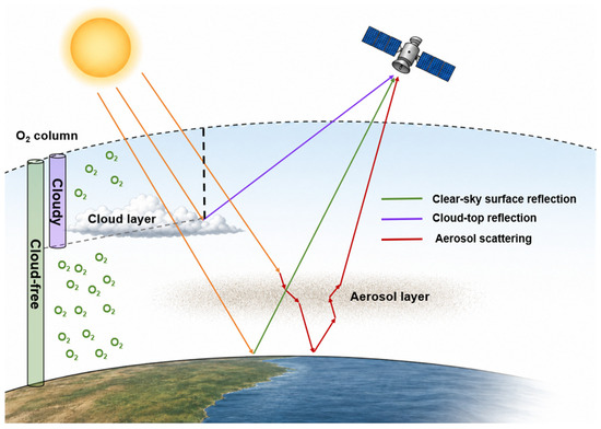
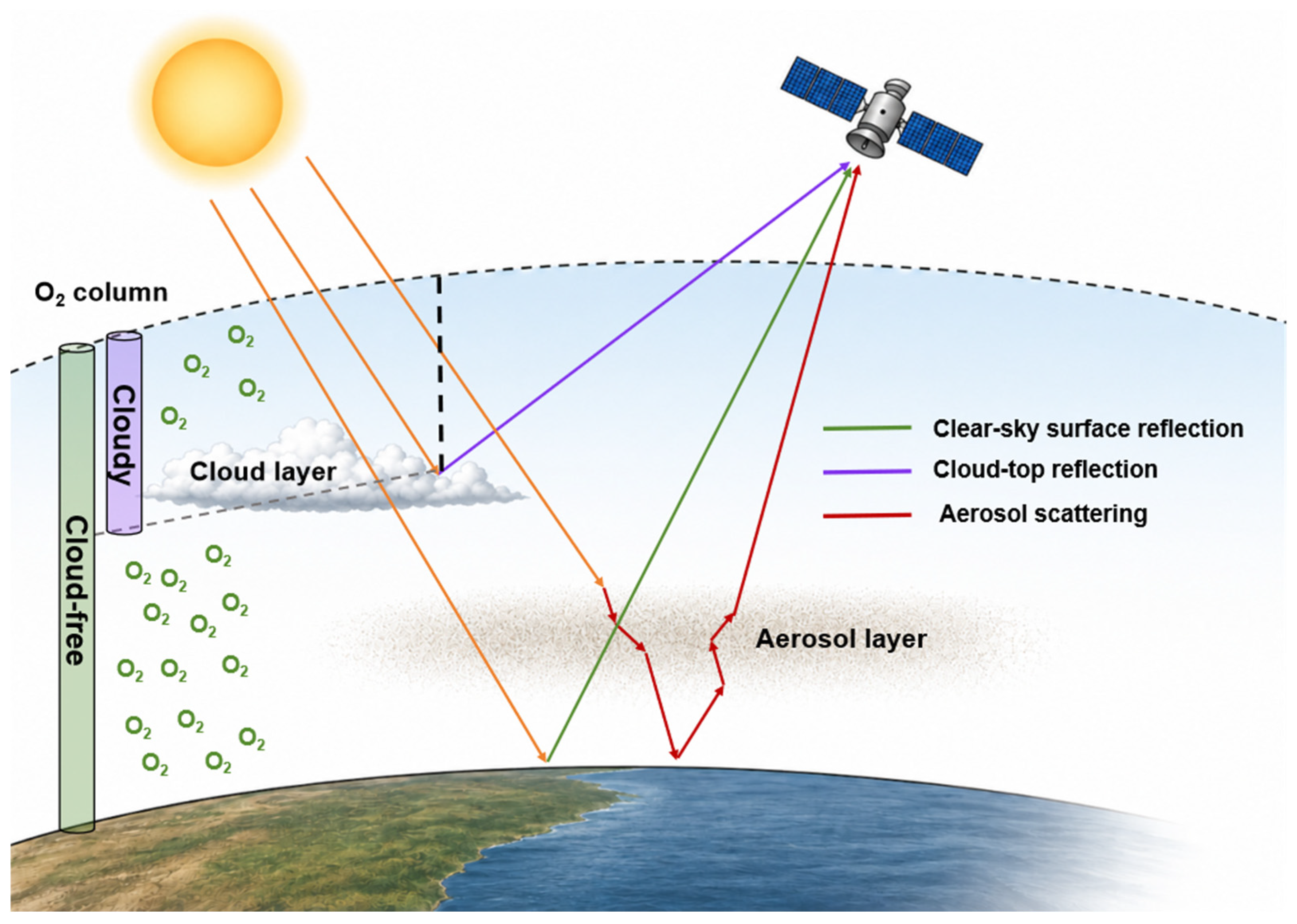
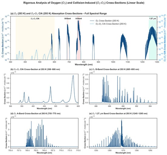
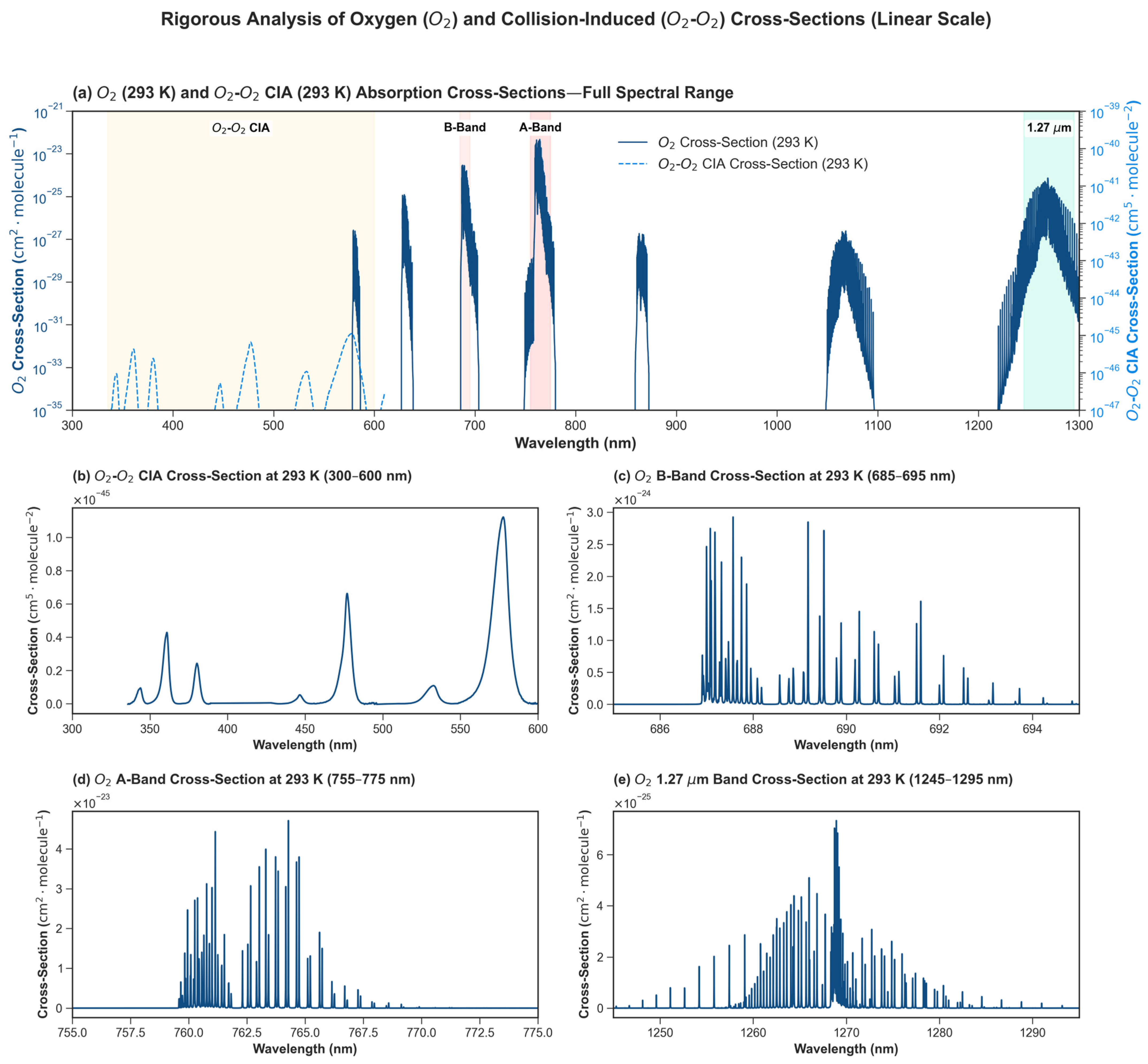
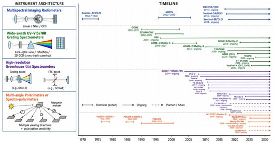
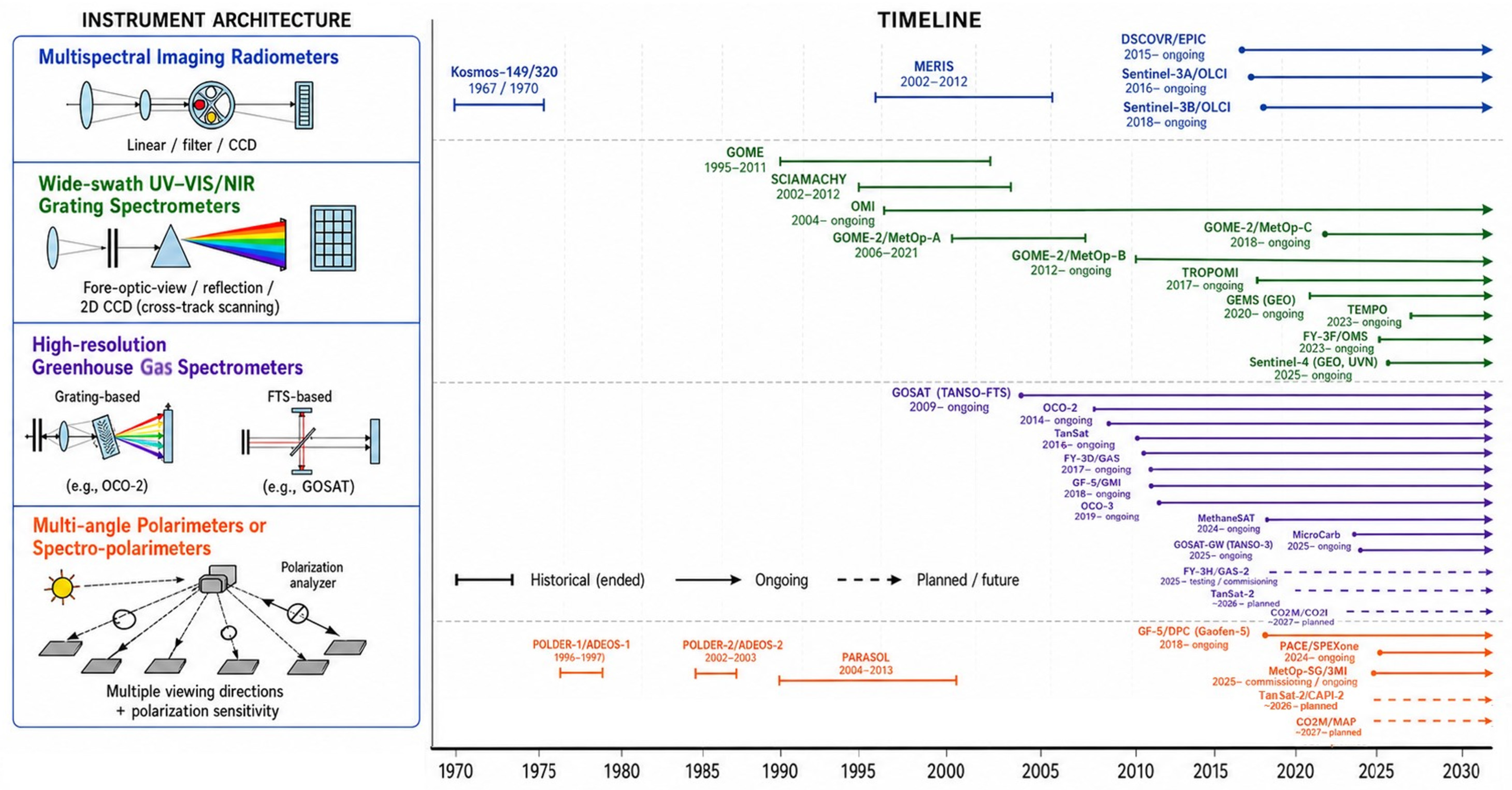
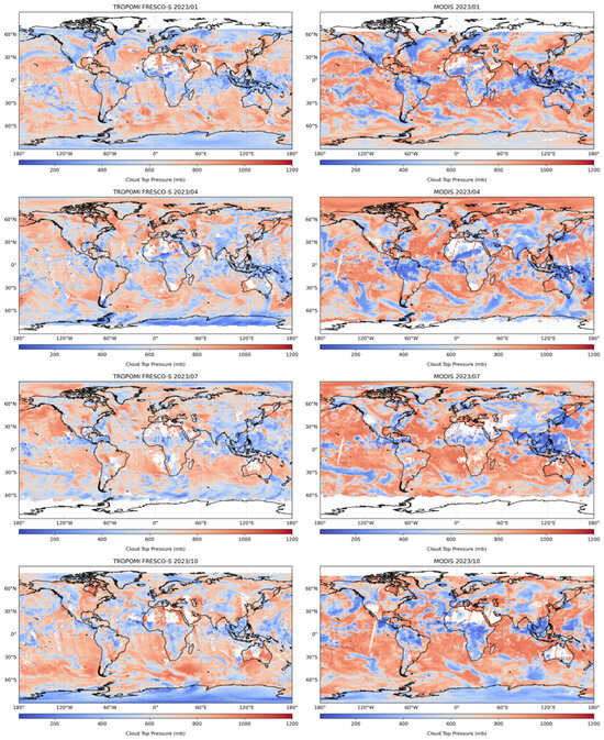
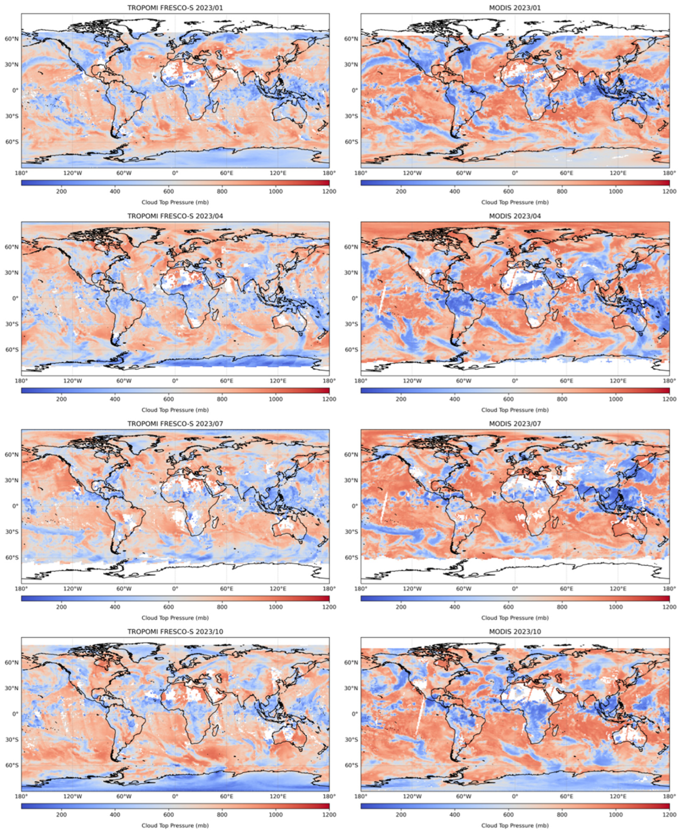
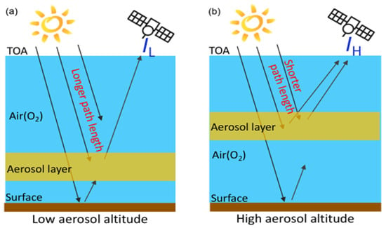
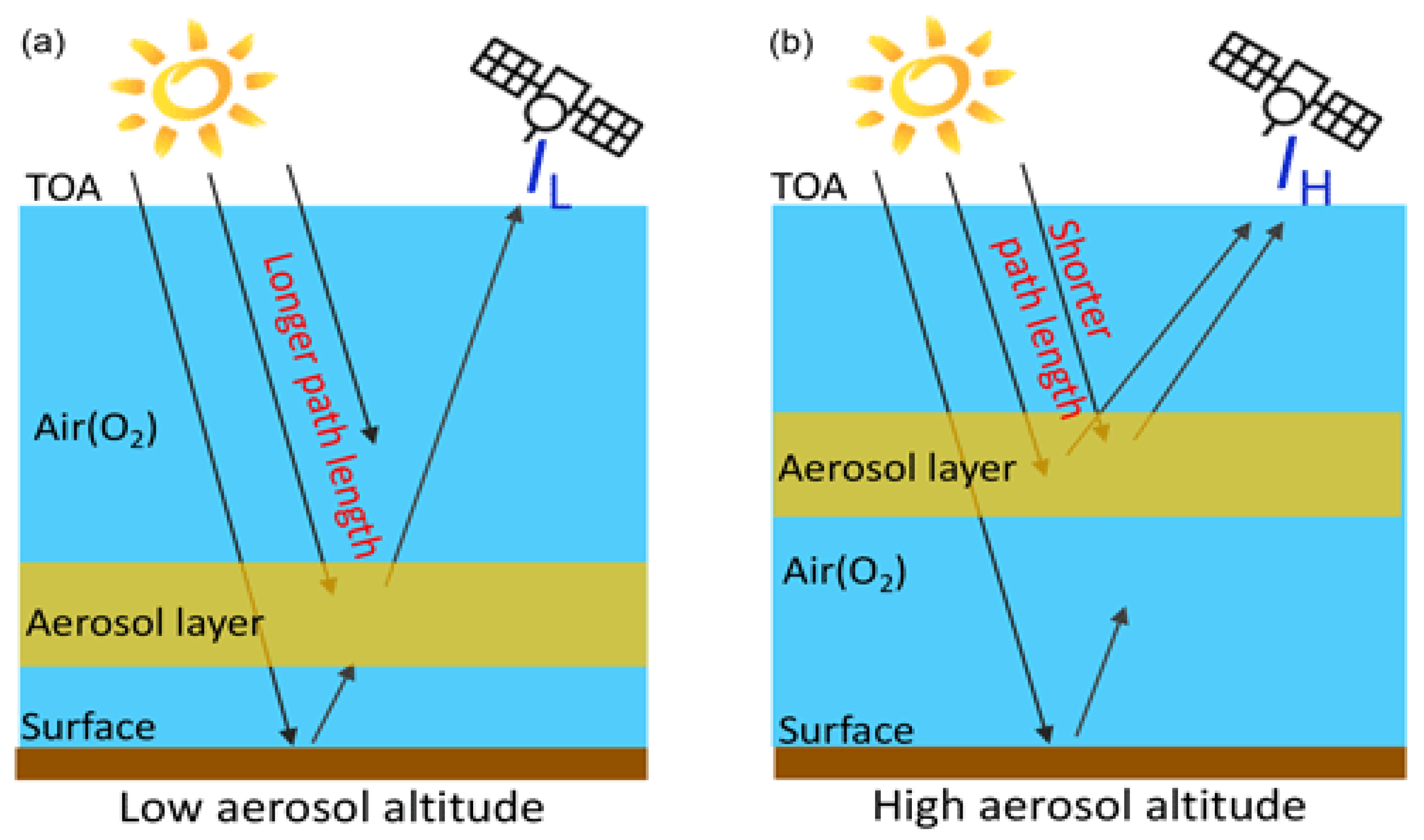
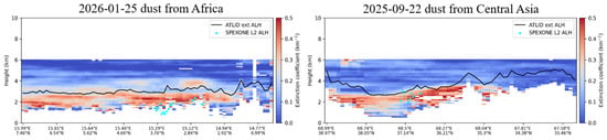
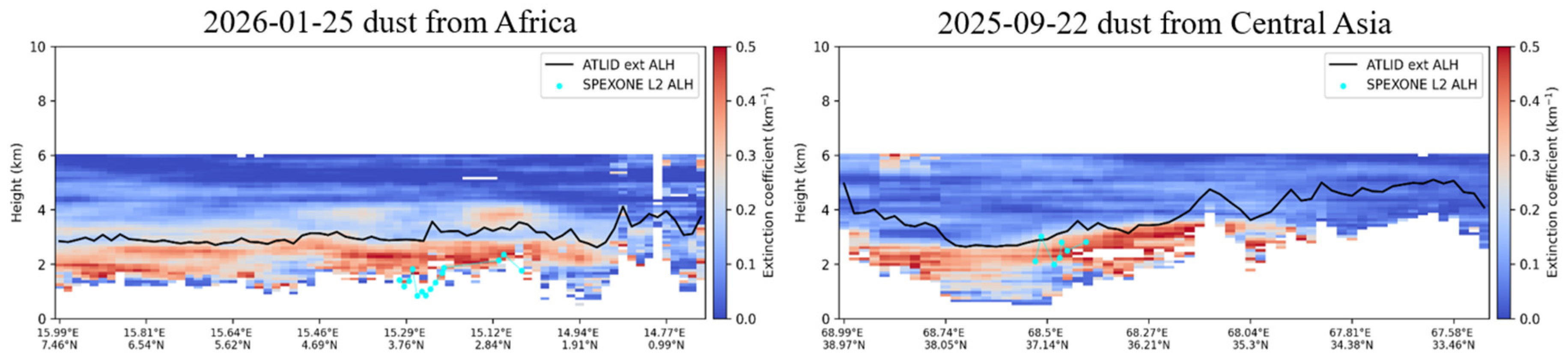
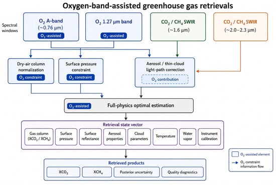
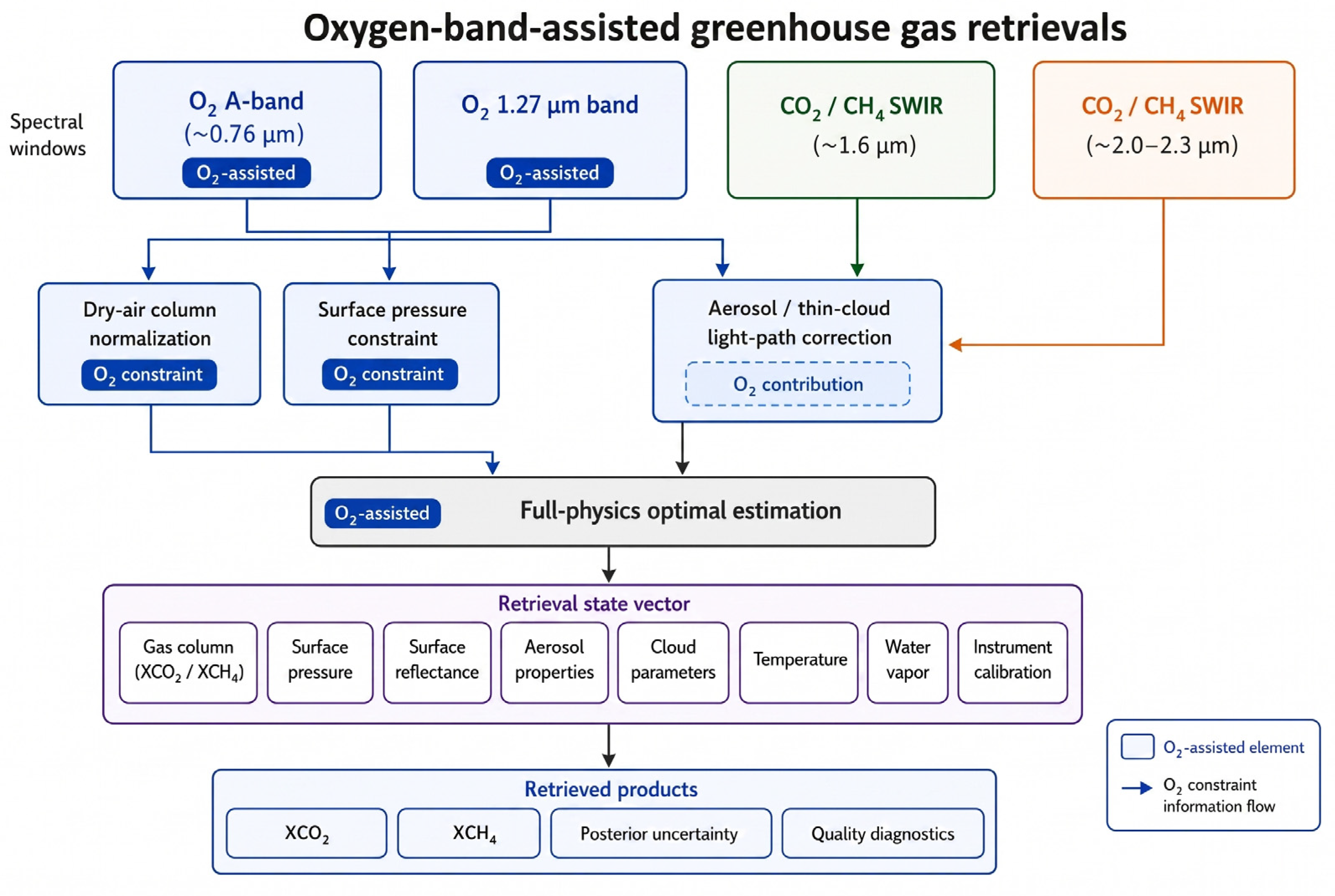
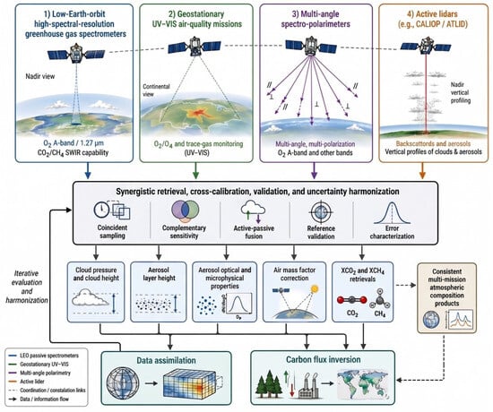
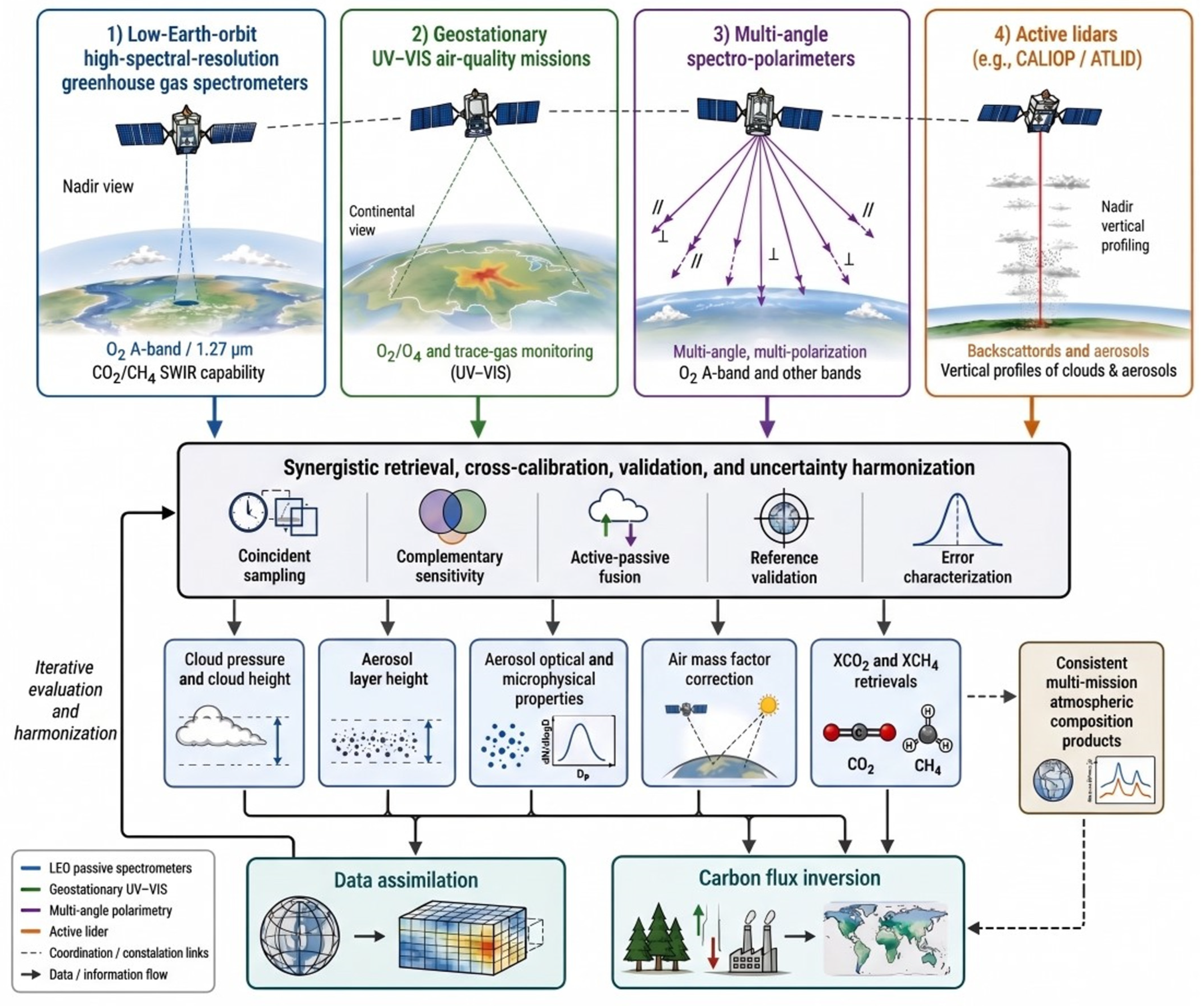

Disclaimer/Publisher’s Note: The statements, opinions and data contained in all publications are solely those of the individual author(s) and contributor(s) and not of MDPI and/or the editor(s). MDPI and/or the editor(s) disclaim responsibility for any injury to people or property resulting from any ideas, methods, instructions or products referred to in the content. |
© 2026 by the authors. Licensee MDPI, Basel, Switzerland. This article is an open access article distributed under the terms and conditions of the Creative Commons Attribution (CC BY) license.