
Large-Area, High-Resolution Tree Cover Mapping with Multi-Temporal SPOT5 Imagery, New South Wales, Australia

Abstract
:
1. Introduction
1.1. Tree Cover Maps for Natural Resource Monitoring
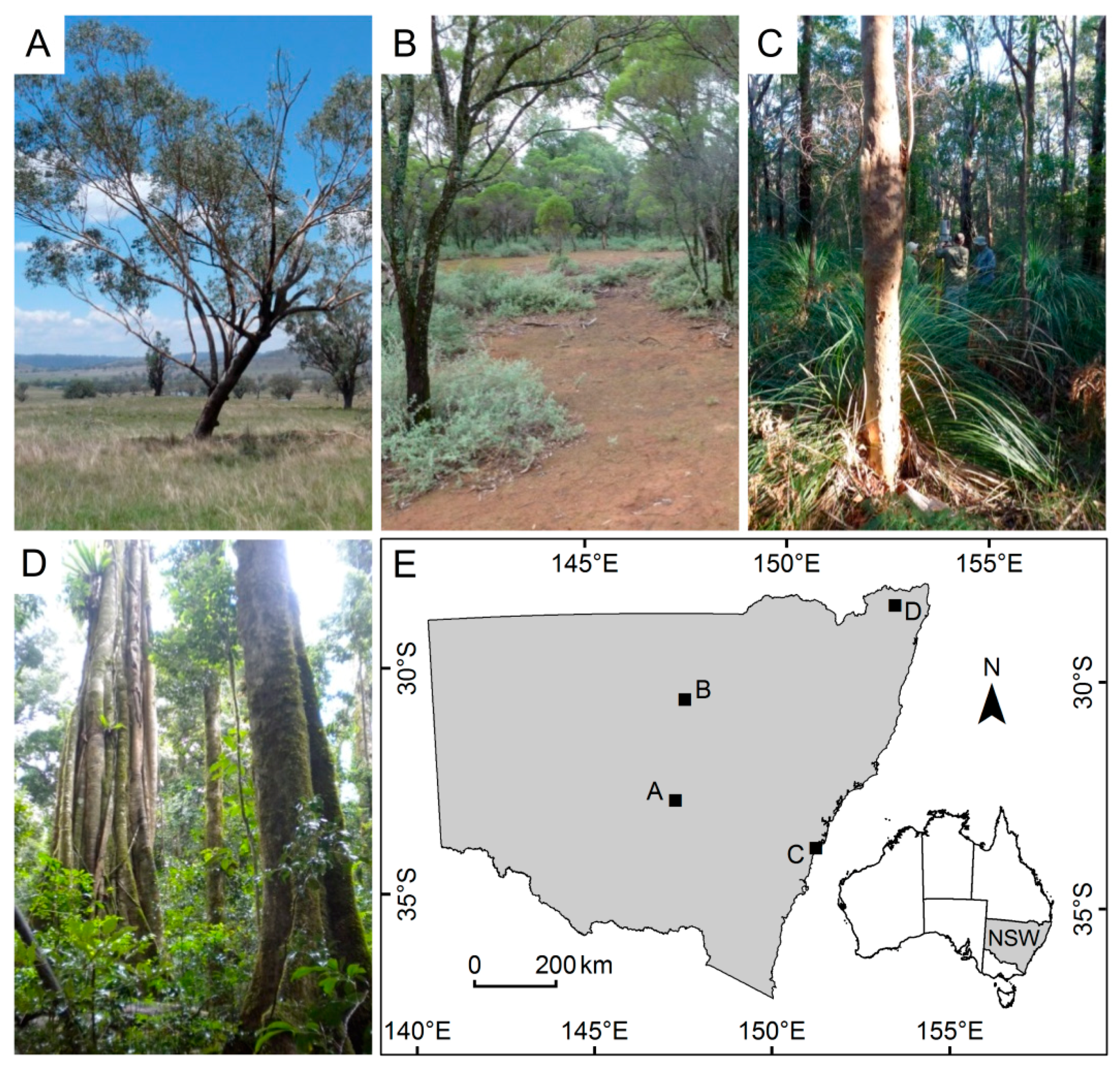
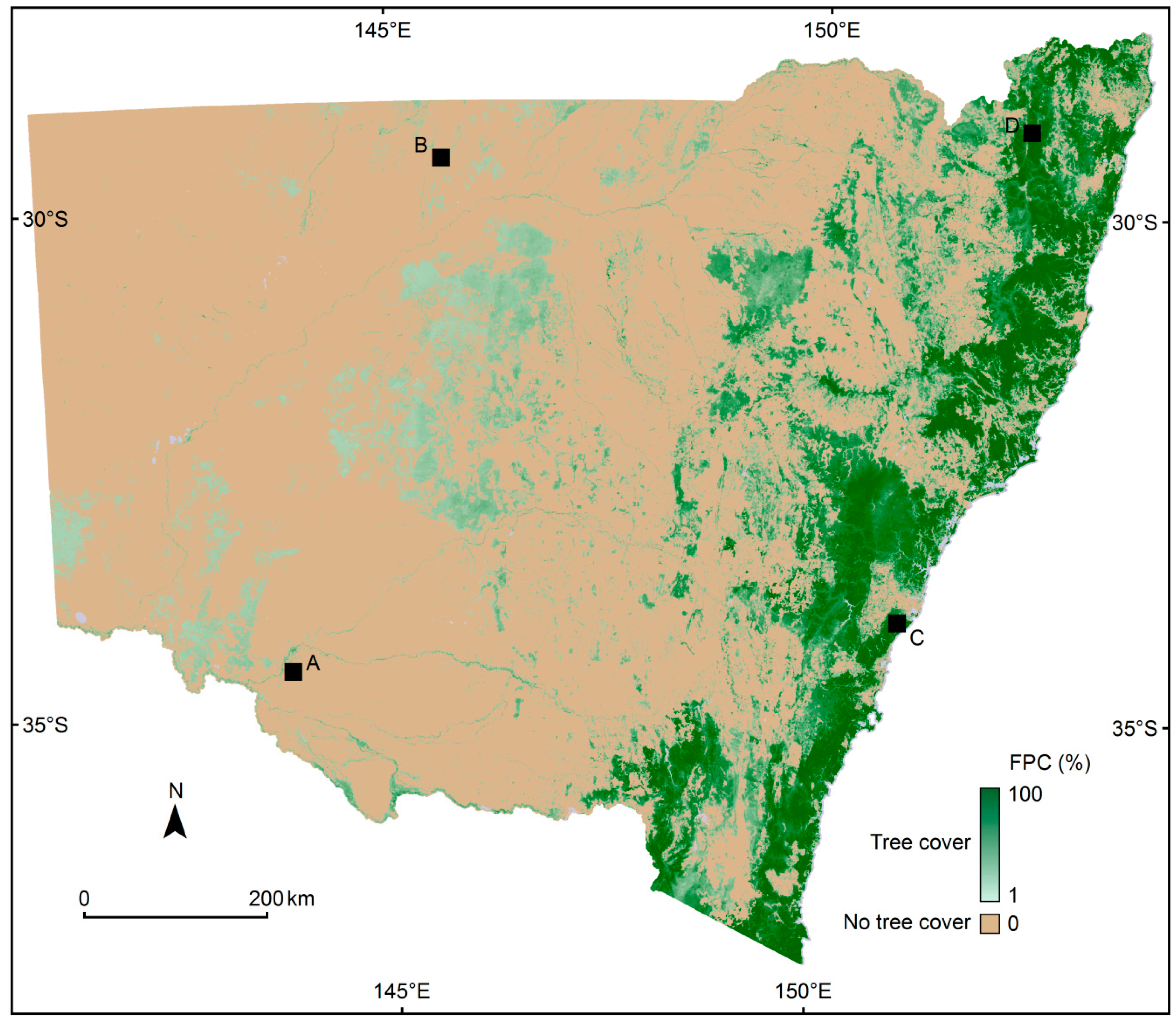
1.2. Study Area
1.3. Tree Cover in the Australian Context
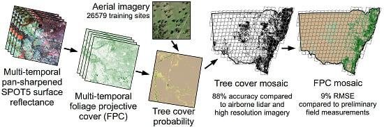
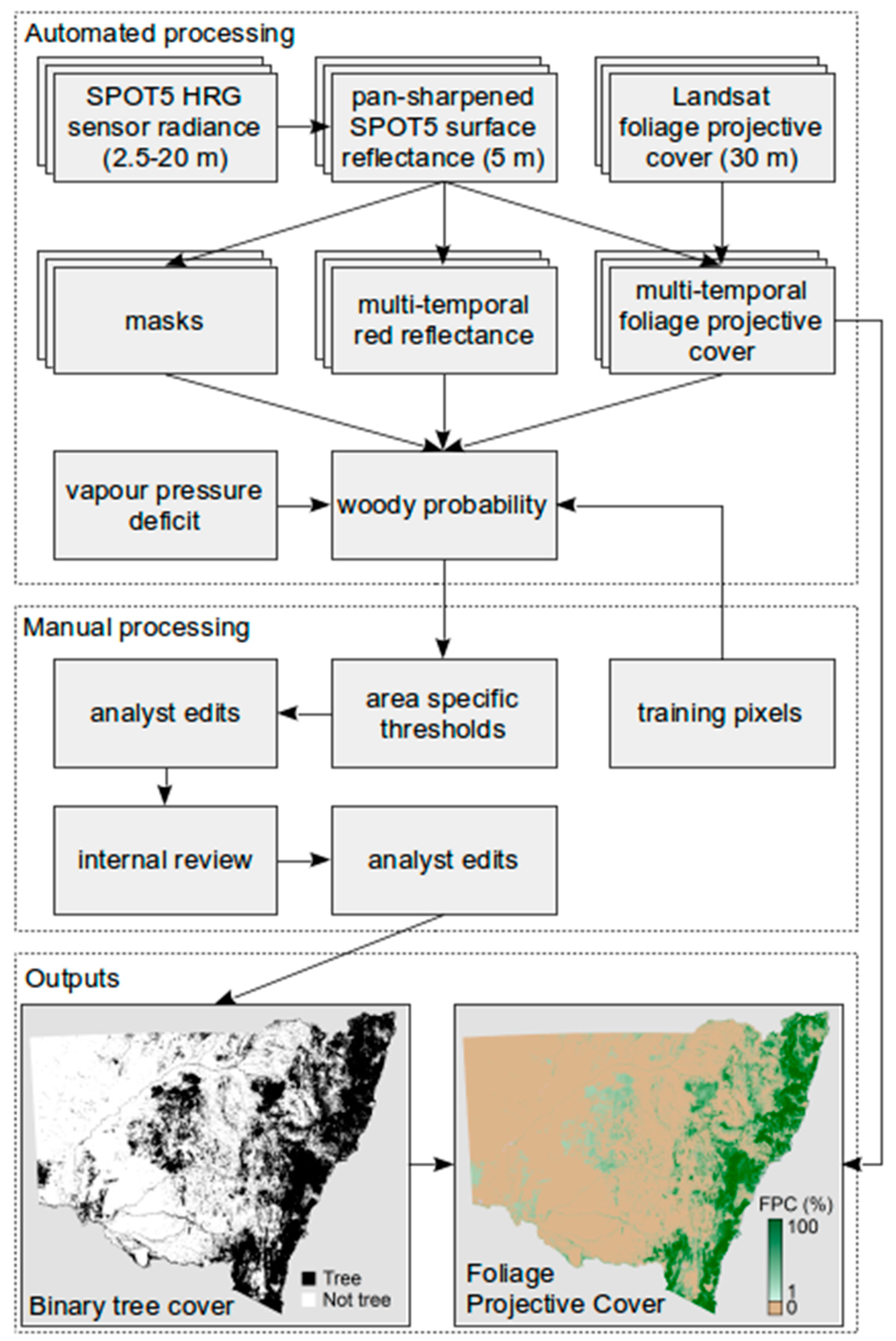
2. Materials and Methods
2.1. Multi-Temporal SPOT5 Pan-Sharpened Surface Reflectance
2.1.1. Ortho-Rectification
2.1.2. Surface Reflectance
2.1.3. Pan-Sharpening
2.1.4. Mask Creation
2.2. Multi-Temporal Foliage Projected Cover
2.3. Tree Cover Probability
2.4. Binary Tree Cover
2.5. Foliage Projective Cover
2.6. Validation
2.6.1. Field Data
2.6.2. Airborne Lidar Data
2.6.3. Visual Interpretation of High Resolution Imagery
3. Results
3.1. Foliage Projected Cover
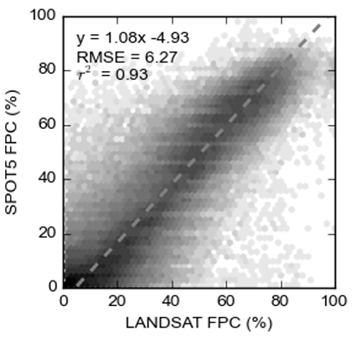
3.1.1. Comparison to Landsat
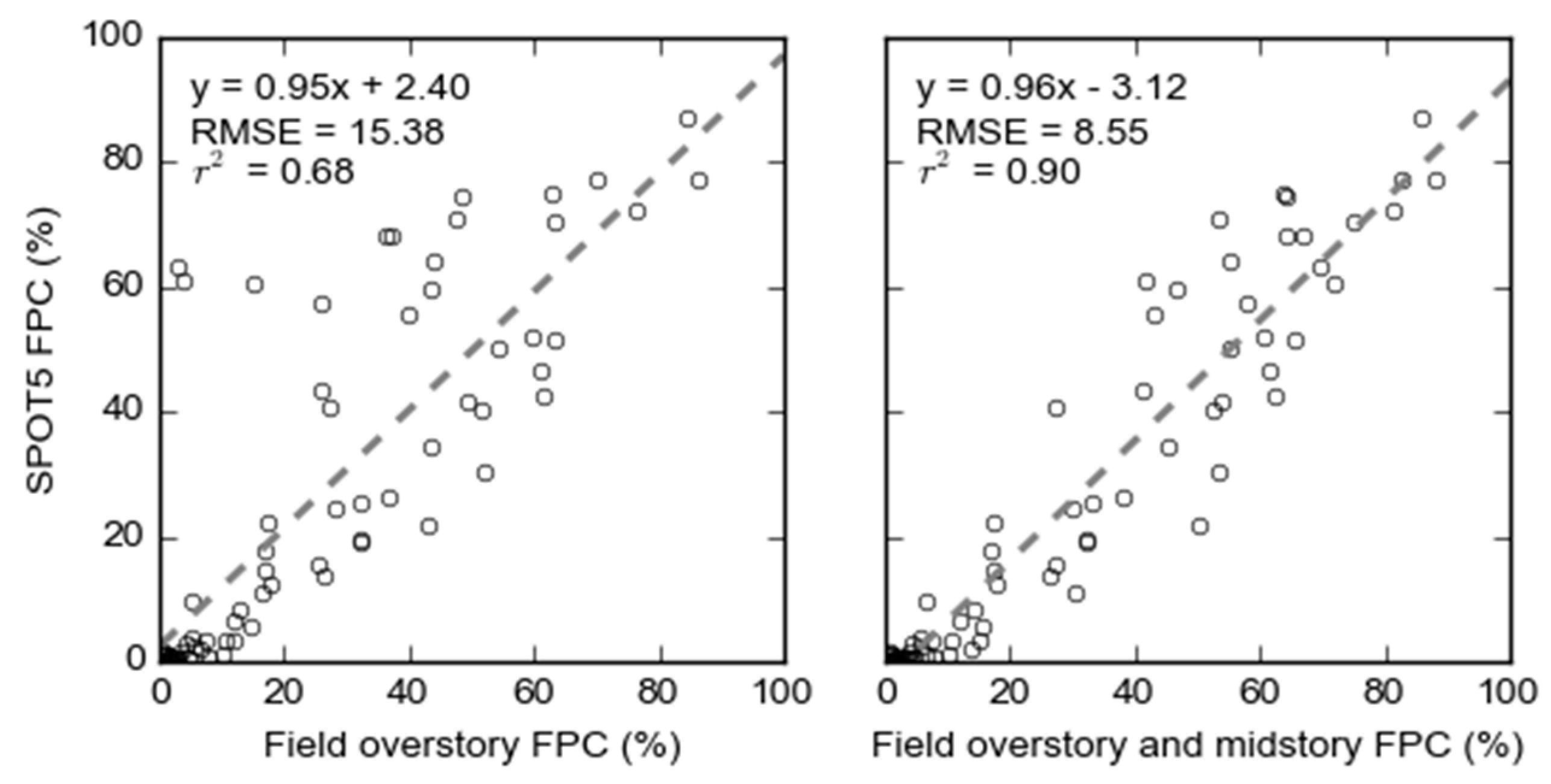
3.1.2. Field Data
3.2. Binary Tree Cover
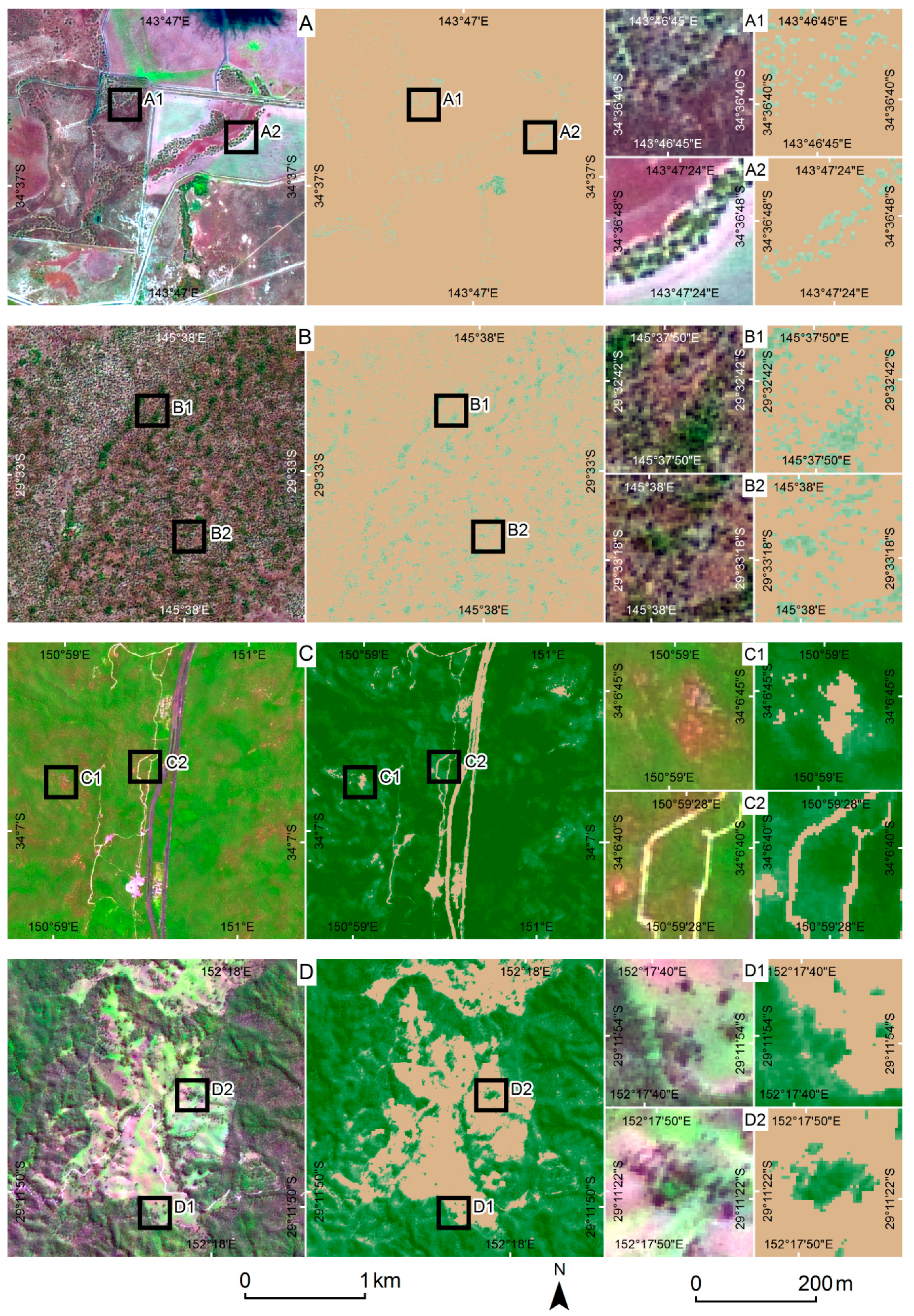
3.2.1. Visual Assessment
3.2.2. Lidar
4. Discussion
4.1. Map Accuracy
4.2. Statewide Distribution of Tree Cover
4.3. Future Research
5. Conclusions
Supplementary Materials
Acknowledgments
Author Contributions
Conflicts of Interest
Abbreviations
| ALOS-2 | Advanced Land Observing Satellite 2 |
| DEM | digital elevation model |
| FPC | foliage projective cover |
| FPR | false positive rate |
| JRSRP | Joint Remote Sensing Research Program |
| NIR | near infrared |
| NSW | New South Wales |
| PALSAR | Phased Array type L-band Synthetic Aperture Radar |
| PPC | plant projective cover |
| QLD | Queensland |
| RMSE | root mean square error |
| SLATS | Statewide Landcover and Trees Study |
| SPOT5 | Satellite pour l’Observation de la Terre 5 |
| SRTM | Shuttle Radar Topography Mission |
| SWIR | shortwave infrared |
| TPR | true positive rate |
| VPD | vapour pressure deficit |
References
- Haddad, N.M.; Brudvig, L.A.; Clobert, J.; Davies, K.F.; Gonzalez, A.; Holt, R.D.; Lovejoy, T.E.; Sexton, J.O.; Austin, M.P.; Collins, C.D.; et al. Habitat fragmentation and its lasting impact on Earth’s ecosystems. Sci. Adv. 2015, 1, e1500052. [Google Scholar] [CrossRef] [PubMed]
- Antos, M.; White, J. Birds of remnant vegetation on the Mornington Peninsula, Victoria, Australia: The role of interiors, edges and roadsides. Paci. Conserv. Biol. 2004, 9, 294–301. [Google Scholar] [CrossRef]
- Debuse, V.J.; King, J.; House, A.P.N. Effect of fragmentation, habitat loss and within-patch habitat characteristics on ant assemblages in semi-arid woodlands of Eastern Australia. Landsc. Ecol. 2007, 22, 731–745. [Google Scholar] [CrossRef]
- Ford, H.A.; Walters, J.R.; Cooper, C.B.; Debus, S.J.S.; Doerr, V.A.J. Extinction debt or habitat change?—Ongoing losses of woodland birds in North-Eastern New South Wales, Australia. Biol. Conserv. 2009, 142, 3182–3190. [Google Scholar] [CrossRef]
- Holland, G.J.; Bennett, A.F. Habitat fragmentation disrupts the demography of a widespread native mammal. Ecography 2010, 33, 841–853. [Google Scholar] [CrossRef]
- Ross, K.; Fox, B.; Fox, M. Changes to plant species richness in forest fragments: Fragment age, disturbance and fire history may be as important as area. J. Biogeogr. 2002, 29, 749–765. [Google Scholar] [CrossRef]
- Bradshaw, C.J.A. Little left to lose: Deforestation and forest degradation in Australia since European colonization. J. Plant Ecol. 2012, 5, 109–120. [Google Scholar] [CrossRef]
- Day, M.; Roff, A. Multi-temporal classification of woody vegetation using pan-sharpened SPOT-5 data. In Proceedings of the 16th Australasian Remote Sensing and Photogrammetry Conference (16 ARSPC), Melbourne, Australia, 20–28 August 2012.
- Hansen, M.C.; Potapov, P.V.; Moore, R.; Hancher, M.; Turubanova, S.A.; Tyukavina, A.; Thau, D.; Stehman, S.V.; Goetz, S.J.; Loveland, T.R.; et al. High-resolution global maps of 21st-century forest cover change. Science 2013, 342, 850–853. [Google Scholar] [CrossRef] [PubMed]
- Sexton, J.O.; Song, X.-P.; Feng, M.; Noojipady, P.; Anand, A.; Huang, C.; Kim, D.-H.; Collins, K.M.; Channan, S.; DiMiceli, C.; et al. Global, 30-m resolution continuous fields of tree cover: Landsat-based rescaling of MODIS vegetation continuous fields with lidar-based estimates of error. Int. J. Digit. Earth 2013, 6, 427–448. [Google Scholar] [CrossRef]
- Pengra, B.; Long, J.; Dahal, D.; Stehman, S.V.; Loveland, T.R. A global reference database from very high resolution commercial satellite data and methodology for application to Landsat derived 30 m continuous field tree cover data. Remote Sens. Environ. 2015, 165, 234–248. [Google Scholar] [CrossRef]
- Arroyo, L.A.; Johansen, K.; Armston, J.; Phinn, S. Integration of lidar and quickbird imagery for mapping riparian biophysical parameters and land cover types in Australian tropical savannas. For. Ecol. Manag. 2010, 259, 598–606. [Google Scholar] [CrossRef]
- Brink, A.B.; Eva, H.D. Monitoring 25 years of land cover change dynamics in Africa: A sample based remote sensing approach. Appl. Geogr. 2009, 29, 501–512. [Google Scholar] [CrossRef]
- Cacetta, P.; Furby, S.; Wallace, J.; Wu, X.; Richards, G.; Waterworth, R. Long-term monitoring of Australian land cover change using landsat data: Development, implementation, and operation. In Global Forest Monitoring from Earth Observation; Frederic, A., Hansen, M., Eds.; CRC Press: Boca Raton, FL, USA, 2012; pp. 229–244. [Google Scholar]
- Homer, C.G.; Dewitz, J.A.; Yang, L.; Jin, S.; Danielson, P.; Xian, G.; Coulston, J.; Herold, N.D.; Wickham, J.D.; Megown, K. Completion of the 2011 national land cover database for the conterminous united states-representing a decade of land cover change information. Photogramm. Eng. Remote Sens. 2015, 81, 345–354. [Google Scholar]
- Yemshanov, D.; McKenney, D.W.; Pedlar, J.H. Mapping forest composition from the Canadian national forest inventory and land cover classification maps. Environ. Monit. Assess. 2012, 184, 4655–4669. [Google Scholar] [CrossRef] [PubMed]
- Asner, G.P.; Knapp, D.E.; Broadbent, E.N.; Oliveira, P.J.C.; Keller, M.; Silva, J.N. Selective logging in the Brazilian Amazon. Science 2005, 310, 480–482. [Google Scholar] [CrossRef] [PubMed]
- Hansen, M.C.; Stehman, S.V.; Potapov, P.V. Quantification of global gross forest cover loss. Proc. Natl. Acad. Sci. USA 2010, 107, 8650–8655. [Google Scholar] [CrossRef] [PubMed]
- Lehmann, E.A.; Wallace, J.F.; Caccetta, P.A.; Furby, S.L.; Zdunic, K. Forest cover trends from time series Landsat data for the Australian continent. Int. J. Appl. Earth Obs. Geoinf. 2013, 21, 453–462. [Google Scholar] [CrossRef]
- Townshend, J.R.; Masek, J.G.; Huang, C.; Vermote, E.F.; Gao, F.; Channan, S.; Sexton, J.O.; Feng, M.; Narasimhan, R.; Kim, D.; et al. Global characterization and monitoring of forest cover using Landsat data: Opportunities and challenges. Int. J. Dig. Earth 2012, 5, 373–397. [Google Scholar] [CrossRef]
- Asner, G.P.; Knapp, D.E.; Balaji, A. Automated mapping of tropical deforestation and forest degradation: CLASlite. J. Appl. Remote Sens. 2009, 3, 033543. [Google Scholar] [CrossRef]
- Huang, C.; Yang, L.; Wylie, B.; Homer, C. A strategy for estimating tree canopy density using Landsat 7 ETM+ and high resolution images over large areas. In Proceedings of the Third International Conference on Geospatial Information in Agriculture And Forestry, Denver, CO, USA, 5–7 November 2001.
- Alexander, C.; Bøcher, P.K.; Arge, L.; Svenning, J.-C. Regional-scale mapping of tree cover, height and main phenological tree types using airborne laser scanning data. Remote Sens. Environ. 2014, 147, 156–172. [Google Scholar] [CrossRef]
- Carreiras, J.M.B.; Pereira, J.M.C.; Pereira, J.S. Estimation of tree canopy cover in evergreen oak woodlands using remote sensing. For. Ecol. Manag. 2006, 223, 45–53. [Google Scholar] [CrossRef]
- Danaher, T.; Scath, P.; Armston, J.; Collett, L.; Kitchen, J.; Gillingham, S. Remote sensing of tree-grass systems: The eastern Australian woodlands. In Ecosystem Function in Savannas: Measurement and Modeling at Landscape to Global Scales; Hill, M.J., Hanan, N.P., Eds.; CRC Press: Boca Raton, FL, USA, 2010; pp. 175–194. [Google Scholar]
- Lucas, R.M.; Clewley, D.; Accad, A.; Butler, D.; Armston, J.; Bowen, M.; Bunting, P.; Carreiras, J.; Dwyer, J.; Eyre, T.; et al. Mapping forest growth and degradation stage in the Brigalow Belt Bioregion of Australia through integration of ALOS PALSAR and Landsat-derived foliage projective cover data. Remote Sens. Environ. 2014, 155, 42–57. [Google Scholar] [CrossRef] [Green Version]
- Tansey, K.; Chambers, I.; Anstee, A.; Denniss, A.; Lamb, A. Object-oriented classification of very high resolution airborne imagery for the extraction of hedgerows and field margin cover in agricultural areas. Appl. Geogr. 2009, 29, 145–157. [Google Scholar] [CrossRef]
- Furby, S.L.; Caccetta, P.A.; Wallace, J.F.; Lehmann, E.A.; Zdunic, K. Recent development in vegetation monitoring products from Australia’s national carbon accounting system. In Proceedings of the International Geoscience and Remote Sensing Symposium, Cape Town, South Africa, 12–17 July 2009; Volume 4, pp. 276–279.
- Farmer, E.; Reinke, K.J.; Jones, S.D. A current perspective on Australian woody vegetation maps and implications for small remnant patches. J. Spat. Sci. 2011, 56, 223–240. [Google Scholar] [CrossRef]
- Keith, D.A. Ocean Shores to Desert Dunes: The Native Vegetation of New South Wales and the Act; Department of Environment and Conservation: Hurstville, Australia, 2004.
- Norton, T. Conserving biological diversity in Australia’s temperate eucalypt forests. For. Ecol. Manag. 1996, 85, 21–33. [Google Scholar] [CrossRef]
- Manning, A.D.; Fischer, J.; Lindenmayer, D.B. Scattered trees are keystone structures—Implications for conservation. Biol. Conserv. 2006, 132, 311–321. [Google Scholar] [CrossRef]
- Eldridge, D.; Freudenberger, D. Ecosystem wicks: Woodland trees enhance water infiltration in a fragmented agricultural landscape in Eastern Australia. Austral Ecol. 2005, 30, 336–347. [Google Scholar] [CrossRef]
- Wilson, B. Influence of scattered paddock trees on surface soil properties: A study of the northern tablelands of NSW. Ecol. Manag. Restor. 2002, 3, 211–219. [Google Scholar] [CrossRef]
- Fischer, J.; Lindenmayer, D.B. Small patches can be valuable for biodiversity conservation: Two case studies on birds in southeastern Australia. Biol. Conserv. 2002, 106, 129–136. [Google Scholar] [CrossRef]
- Armston, J.D.; Denham, R.J.; Danaher, T.J.; Scarth, P.F.; Moffiet, T.N. Prediction and validation of foliage projective cover from Landsat-5 TM and Landsat-7 ETM+ imagery. J. Appl. Remote Sens. 2009, 3, 033540. [Google Scholar] [CrossRef]
- Walker, J.; Hopkins, M.S. Australian soil and land survey: Field handbook. In Australian Soil and Land Survey: Field Handbook, 2nd ed.; McDonald, R.C., Isbell, R.F., Speight, J.G., Walker, J., Hopkins, M.S., Eds.; CSIRO: Canberra, Australia, 1990; p. 190. [Google Scholar]
- Specht, R.L. Foliage projective covers of overstory and understory strata of mature vegetation in Australia. Austral Ecol. 1983, 8, 433–439. [Google Scholar] [CrossRef]
- Carruthers, S.; Bickerton, H.; Carpenter, G.; Brook, A.; Hodder, M. A Landscape Approach to Determine the Ecological Value of Paddock Trees: Summary Report Years 1 and 2; Department of Water Land and Biodiversity Conservation: Adeliade, Australia, 2004.
- Gill, T.; Clark, A.; Scarth, P.; Danaher, T.; Gillingham, S.; Armston, J.; Phinn, S. Alternatives to Landsat-5 Thematic Mapper for operational monitoring of vegetation cover: Considerations for natural resource management agencies. Can. J. Remote Sens. 2010, 36, 682–698. [Google Scholar] [CrossRef]
- Flood, N.; Danaher, T.; Gill, T.; Gillingham, S. An operational scheme for deriving standardised surface reflectance from Landsat TM/ETM+ and SPOT HRG imagery for eastern Australia. Remote Sens. 2013, 5, 83–109. [Google Scholar] [CrossRef]
- Farr, T.G.; Rosen, P.A.; Caro, E.; Crippen, R.; Duren, R.; Hensley, S.; Kobrick, M.; Paller, M.; Rodriguez, E.; Roth, L.; et al. The Shuttle Radar Topography mission. Rev. Geophys. 2007, 45, RG2004. [Google Scholar] [CrossRef]
- Gallant, J.; Read, A. Enhancing the SRTM data for Australia. In Proceedings of the Geomorphometry, Zurich, Switzerland, 31 August–2 September 2009.
- Gallant, J. 1 Second SRTM Level 2 Derived Digital Surface Model (DSM) v1.0; Geoscience Australia: Canberra, Australia, 2010.
- Sen, P.K. Estimates of the regression coefficient based on Kendall’s tau. J. Am. Stat. Assoc. 1968, 63, 1379–1389. [Google Scholar] [CrossRef]
- Fisher, A. Cloud and cloud-shadow detection in SPOT5 HRG imagery with automated morphological feature extraction. Remote Sens. 2014, 6, 776–800. [Google Scholar] [CrossRef]
- Fisher, A.; Danaher, T. A water index for SPOT5 HRG satellite imagery, New South Wales, Australia, determined by linear discriminant analysis. Remote Sens. 2013, 5, 5907–5925. [Google Scholar] [CrossRef]
- Robertson, K. Spatial transformation for rapid scan-line surface shadowing. IEEE Comput. Graph. Appl. 1989, 9, 30–38. [Google Scholar] [CrossRef]
- Moffiet, T.; Armston, J.D.; Mengersen, K. Motivation, development and validation of a new spectral greenness index: A spectral dimension related to foliage projective cover. ISPRS J. Photogramm. Remote Sens. 2010, 65, 26–41. [Google Scholar] [CrossRef]
- Jeffrey, S.J.; Carter, J.O.; Moodie, K.B.; Beswick, A.R. Using spatial interpolation to construct a comprehensive archive of Australian climate data. Environ. Model. Softw. 2001, 16, 309–330. [Google Scholar] [CrossRef]
- Boggs, G.S. Assessment of SPOT 5 and quickbird remotely sensed imagery for mapping tree cover in savannas. Int. J. Appl. Earth Obs. Geoinf. 2010, 12, 217–224. [Google Scholar] [CrossRef]
- Olofsson, P.; Stehman, S.V.; Woodcock, C.E.; Sulla-Menashe, D.; Sibley, A.M.; Newell, J.D.; Friedl, M.A.; Herold, M. A global land-cover validation data set, Part I: Fundamental design principles. Int. J. Remote Sens. 2012, 33, 5768–5788. [Google Scholar] [CrossRef]
- White, M.A.; Shaw, J.D.; Ramsey, R.D. Accuracy assessment of the vegetation continuous field tree cover product using 3954 ground plots in the south-western USA. Int. J. Remote Sens. 2005, 26, 2699–2704. [Google Scholar] [CrossRef]
- Wickham, J.D.; Stehman, S.V.; Fry, J.A.; Smith, J.H.; Homer, C.G. Thematic accuracy of the NLCD 2001 land cover for the conterminous United States. Remote Sens. Environ. 2010, 114, 1286–1296. [Google Scholar] [CrossRef]
- Herold, M.; Latham, J.S.; Di Gregorio, A.; Schmullius, C.C. Evolving standards in land cover characterization. J. Land Use Sci. 2006, 1, 157–168. [Google Scholar] [CrossRef]
- Wulder, M.A.; White, J.C.; Nelson, R.F.; Næsset, E.; Ørka, H.O.; Coops, N.C.; Hilker, T.; Bater, C.W.; Gobakken, T. Lidar sampling for large-area forest characterization: A review. Remote Sens. Environ. 2012, 121, 196–209. [Google Scholar] [CrossRef]
- Bontemps, S.; Langner, A.; Defourny, P. Monitoring forest changes in borneo on a yearly basis by an object-based change detection algorithm using SPOT-VEGETATION time series. Int. J. Remote Sens. 2012, 33, 4673–4699. [Google Scholar] [CrossRef]
- De Fries, R.S.; Hansen, M.; Townshend, J.R.G.; Sohlberg, R. Global land cover classifications at 8 km spatial resolution: The use of training data derived from Landsat imagery in decision tree classifiers. Int. J. Remote Sens. 1998, 19, 3141–3168. [Google Scholar] [CrossRef]
- Mayaux, P.; Pekel, J.F.; Desclee, B.; Donnay, F.; Lupi, A.; Achard, F.; Clerici, M.; Bodart, C.; Brink, A.; Nasi, R.; et al. State and evolution of the African rainforests between 1990 and 2010. Philos. Trans. R. Soc. Lond. Ser. B Biol. Sci. 2013, 368, 20120300. [Google Scholar] [CrossRef] [PubMed] [Green Version]
- Montesano, P.M.; Nelson, R.; Sun, G.; Margolis, H.; Kerber, A.; Ranson, K.J. Modis tree cover validation for the circumpolar taiga–tundra transition zone. Remote Sens. Environ. 2009, 113, 2130–2141. [Google Scholar] [CrossRef]
- Raši, R.; Bodart, C.; Stibig, H.-J.; Eva, H.; Beuchle, R.; Carboni, S.; Simonetti, D.; Achard, F. An automated approach for segmenting and classifying a large sample of multi-date Landsat imagery for pan-tropical forest monitoring. Remote Sens. Environ. 2011, 115, 3659–3669. [Google Scholar] [CrossRef]
- Muir, J.; Schmidt, M.; Tindall, D.; Trvithick, R.; Scarth, P.; Stewart, J. Field Measurement of Fractional Ground Cover: A Technical Handbook Supporting Ground Cover Monitoring for Australia; Queensland Department of Environment and Resource Management for the Australian Bureau of Agricultural and Resource Economics and Sciences: Canberra, Australia, 2011.
- Keith, D.A.; Simpson, C.C. Vegetation Formations of Nsw, Version 3.01 (vis-id 3848); Office of Environment and Heritage: Hurstville, Australia, 2010.
- Pink, B. Australian Statistical Geography Standard (Asgs): Volume 4—Significant Urban Areas, Urban Centres and Localities; Australian Bureau of Statistics: Canberra, Australia, 2012.
- Bunting, P.; Armston, J.; Lucas, R.M.; Clewley, D. Sorted pulse data (SPD) library. Part I: A generic file format for lidar data from pulsed laser systems in terrestrial environments. Comput. Geosci. 2013, 56, 197–206. [Google Scholar] [CrossRef]
- Bunting, P.; Armston, J.; Clewley, D.; Lucas, R.M. Sorted pulse data (SPD) library. Part II: A processing framework for lidar data from pulsed laser systems in terrestrial environments. Comput. Geosci. 2013, 56, 207–215. [Google Scholar] [CrossRef]
- Stehman, S.V. Estimating area and map accuracy for stratified random sampling when the strata are different from the map classes. Int. J. Remote Sens. 2014, 35, 4923–4939. [Google Scholar] [CrossRef]
- Sandau, R.; Braunecker, B.; Driescher, H.; Eckardt, A.; Hilbert, S.; Hutton, J.; Kirchhofer, W.; Lithopoulos, E.; Reulke, R.; Wicki, S. Design principles of the LH systems ADS40 airborne digital sensor. Int. Arch. Photogramm. Remote Sens. 2000, XXXIII Part B1, 258–265. [Google Scholar]
- Clewley, D.; Lucas, R.; Accad, A.; Armston, J.; Bowen, M.; Dwyer, J.; Pollock, S.; Bunting, P.; McAlpine, C.; Eyre, T.; et al. An approach to mapping forest growth stages in Queensland, Australia through integration of ALOS PALSAR and Landsat sensor data. Remote Sens. 2012, 4, 2236–2255. [Google Scholar] [CrossRef] [Green Version]
- Lucas, R.; Cronin, N.; Moghaddam, M.; Lee, A.; Armston, J.; Bunting, P.; Witte, C. Integration of radar and Landsat-derived foliage projected cover for woody regrowth mapping, Queensland, Australia. Remote Sens. Environ. 2006, 100, 388–406. [Google Scholar] [CrossRef]
- Lucas, R.; Armston, J.; Carreiras, J.; Nugroho, N.; Clewley, D.; de Grandi, F. Advances in the integration of ALOS PALSAR and Landsat sensor data for forest characterisation, mapping and monitoring. In Proceedings of the 2010 IEEE International Geoscience and Remote Sensing Symposium, Honolulu, HI, USA, 25–30 July 2010; pp. 1851–1854.


| High Resolution Imagery Validation of the Tree Cover with Threshold Map (n = 6648) | |||||
| Reference | Total | User’s Accuracy | |||
| Tree | Not Tree | ||||
| Classification | Tree | 25.4 | 4.6 | 30.0 | 85 (0.99) |
| Not tree | 8.6 | 61.4 | 70.0 | 88 (0.65) | |
| Total | 34.0 | 66.0 | 100.0 | ||
| Producer’s accuracy | 75 (1.21) | 93 (0.49) | Overall = 87 (0.56) | ||
| High Resolution Imagery Validation of the Final Tree Cover Map (n = 6648) | |||||
| Reference | Total | User’s Accuracy | |||
| Tree | Not Tree | ||||
| Classification | Tree | 24.9 | 2.8 | 27.7 | 90 (0.73) |
| Not tree | 9.1 | 63.2 | 72.3 | 87 (0.64) | |
| Total | 34.0 | 66.0 | 100.0 | ||
| Producer’s accuracy | 73 (1.21) | 96 (0.32) | Overall = 88 (0.51) | ||
| Airborne Lidar Validation of the Tree Cover with Threshold Map (n = 13,884,067) | |||||
| Reference | Total | User’s Accuracy | |||
| Tree | Not Tree | ||||
| Classification | Tree | 24.5 | 5.5 | 30.0 | 82 |
| Not tree | 8.4 | 61.6 | 70.0 | 88 | |
| Total | 32.9 | 67.1 | 100.0 | ||
| Producer’s accuracy | 75 | 92 | Overall = 86 | ||
| Airborne Lidar Validation of the Final Tree Cover Map (n = 13,884,067) | |||||
| Reference | Total | User’s Accuracy | |||
| Tree | Not Tree | ||||
| Classification | Tree | 24.1 | 3.0 | 27.1 | 89 |
| Not tree | 8.7 | 64.2 | 72.9 | 88 | |
| Total | 32.7 | 67.3 | 100.0 | ||
| Producer’s accuracy | 74 | 95 | Overall = 88 | ||
| Pixels | Tree Cover with Threshold | Final Tree Cover | |||
|---|---|---|---|---|---|
| Omission of tree cover | Plant projective cover (%) | 1–25 | 714,532 | 41.7 | 46.2 |
| 25–50 | 903,057 | 20.4 | 22.3 | ||
| 50–75 | 1,437,294 | 9.2 | 9.8 | ||
| 75–100 | 4,780,430 | 2.2 | 2.2 | ||
| Maximum height (m) | 2–10 | 1,596,934 | 22.3 | 24.3 | |
| 10–20 | 2,996,969 | 9.4 | 10.7 | ||
| 20–30 | 2,339,621 | 3.1 | 2.8 | ||
| >30 | 901,789 | 0.7 | 0.5 | ||
| Distance to edge (m) | <10 | 1,497,545 | 35.8 | 39.0 | |
| 10–20 | 1,477,179 | 9.3 | 10.8 | ||
| 20–30 | 911,927 | 2.1 | 2.2 | ||
| >30 | 3,948,662 | 0.6 | 0.4 | ||
| Size of region (ha) | <1 | 377,132 | 57.8 | 61.1 | |
| 1–2 | 77,433 | 43.5 | 45.8 | ||
| 2–3 | 40,860 | 33.0 | 36.2 | ||
| >3 | 7,339,888 | 6.2 | 6.8 | ||
| Commission of tree cover | Maximum height (m) | 0–0.5 | 5,414,758 | 12.9 | 6.2 |
| 0.5–1 | 216,872 | 49.5 | 36.8 | ||
| 1–1.5 | 175,094 | 55.1 | 46.9 | ||
| 1.5–2 | 242,030 | 63.0 | 41.6 | ||
| Distance to edge (m) | <10 | 1,174,146 | 37.6 | 33.2 | |
| 10–20 | 969,622 | 18.3 | 12.3 | ||
| 20–30 | 583,010 | 12.7 | 5.7 | ||
| >30 | 3,321,976 | 11.0 | 1.8 | ||
| Size of region (ha) | <1 | 279,703 | 63.8 | 59.0 | |
| 1–2 | 38,068 | 45.1 | 39.3 | ||
| 2–3 | 33,729 | 43.3 | 32.5 | ||
| >3 | 5,697,254 | 14.9 | 7.2 | ||
© 2016 by the authors; licensee MDPI, Basel, Switzerland. This article is an open access article distributed under the terms and conditions of the Creative Commons Attribution (CC-BY) license (http://creativecommons.org/licenses/by/4.0/).
Share and Cite
Fisher, A.; Day, M.; Gill, T.; Roff, A.; Danaher, T.; Flood, N. Large-Area, High-Resolution Tree Cover Mapping with Multi-Temporal SPOT5 Imagery, New South Wales, Australia. Remote Sens. 2016, 8, 515. https://doi.org/10.3390/rs8060515
Fisher A, Day M, Gill T, Roff A, Danaher T, Flood N. Large-Area, High-Resolution Tree Cover Mapping with Multi-Temporal SPOT5 Imagery, New South Wales, Australia. Remote Sensing. 2016; 8(6):515. https://doi.org/10.3390/rs8060515
Chicago/Turabian StyleFisher, Adrian, Michael Day, Tony Gill, Adam Roff, Tim Danaher, and Neil Flood. 2016. "Large-Area, High-Resolution Tree Cover Mapping with Multi-Temporal SPOT5 Imagery, New South Wales, Australia" Remote Sensing 8, no. 6: 515. https://doi.org/10.3390/rs8060515
APA StyleFisher, A., Day, M., Gill, T., Roff, A., Danaher, T., & Flood, N. (2016). Large-Area, High-Resolution Tree Cover Mapping with Multi-Temporal SPOT5 Imagery, New South Wales, Australia. Remote Sensing, 8(6), 515. https://doi.org/10.3390/rs8060515