Article

Proposed Supercluster-Based UMBBFS Routing Protocol for Emergency Message Dissemination in Edge-RSU for 5G VANET

1
LETI Laboratory, University of Sfax, Sfax 3000, Tunisia
2
LETI Laboratory, ENIS National School of Electronics and Telecommunications of Sfax, Sfax 3000, Tunisia
3
Computer Center, University of Anbar, Anbar 55431, Iraq
*
Authors to whom correspondence should be addressed.
Computers 2024, 13(8), 208; https://doi.org/10.3390/computers13080208
Submission received: 8 June 2024 / Revised: 13 August 2024 / Accepted: 14 August 2024 / Published: 19 August 2024

Abstract

:
Vehicular ad hoc networks (VANETs) can bolster road safety through the proactive dissemination of emergency messages (EMs) among vehicles, effectively reducing the occurrence of traffic-related accidents. It is difficult to transmit EMs quickly and reliably due to the high-speed mobility of VANET and the attenuation of the wireless signal. However, poor network design and high vehicle mobility are the two most difficult problems that affect VANET’s network performance. The real-time traffic situation and network dependability will also be significantly impacted by route selection and message delivery. Many of the current works have undergone studies focused on forwarder selection and message transmission to address these problems. However, these earlier approaches, while effective in forwarder selection and routing, have overlooked the critical aspects of communication overhead and excessive energy consumption, resulting in transmission delays. To address the prevailing challenges, the proposed solutions use edge computing to process and analyze data locally from surrounding cars and infrastructure. EDGE-RSUs are positioned by the side of the road. In intelligent transportation systems, this lowers latency and enhances real-time decision-making by employing proficient forwarder selection techniques and optimizing the dissemination of EMs. In the context of 5G-enabled VANET, this paper introduces a novel routing protocol, namely, the supercluster-based urban multi-hop broadcast and best forwarder selection protocol (UMB-BFS). The improved twin delay deep deterministic policy gradient (IT3DPG) method is used to select the target region for emergency message distribution after route selection. Clustering is conducted using modified density peak clustering (MDPC). Improved firefly optimization (IFO) is used for optimal path selection. In this way, all emergency messages are quickly disseminated to multiple directions and also manage the traffic in VANET. Finally, we plotted graphs for the following metrics: throughput (3.9 kbps), end-to-end delay (70), coverage (90%), packet delivery ratio (98%), packet received (12.75 k), and transmission delay (57 ms). Our approach’s performance is examined using numerical analysis, demonstrating that it performs better than the current methodologies across all measures.

1. Introduction

In VANETs, safety applications rely mainly on broadcasting emergency messages (EMs). The network operates by broadcasting beacon messages from every vehicle, allowing them to self-identify. To establish a connection with nearby vehicles, the receiving vehicle stores key information from these beacon messages, including the sender’s address, velocity, position, and vehicle status. This proactive approach aims to efficiently determine the most suitable relay node for transmitting emergency messages by pinpointing the closest available vehicle. Additionally, specific guidelines for broadcasting emergency alerts have been established to ensure precise and reliable message delivery [1]. The performance of the RSBP-RF (relay selection based on proximity with radio frequency) system is assessed in terms of end-to-end message dissemination latency, the accuracy of relay node selection, and the overall message delivery success rate. It has been observed that the packet delivery ratio (PDR) increases significantly with higher vehicle density, indicating improved message transmission reliability as the number of vehicles in the network grows [2]. The great mobility and dispersion of the nodes (vehicles) provide communication problems. To facilitate communication between cars and roadside units (RSUs), nodes in the overall architectures of VANETs are outfitted with on-board units (OBUs). The OBUs and municipal infrastructures are integrated through the RSUs, which are static nodes placed along the roadways (static locations). OBUs employ opportunistic routing to transfer information throughout the vehicular network when vehicles interact with RSUs or other vehicles. VANETs have significant issues related to the high mobility of the nodes, their vast geographic dispersion, and continuous changes in the network structure, resulting in intermittent connections owing to network fragmentation [3]. Emergency communication in VANET is a critical aspect of these networks, as it plays a vital role in ensuring the safety of drivers, passengers, and other road users [4].
One of the main features of intelligent transportation systems (ITSs) involves the use of vehicle-to-everything (V2X) communications to enhance road safety and driving conditions by disseminating messages in emergency scenarios like traffic jams and accidents [5,6]. Data sharing between vehicles and RSUs is one of two potential communications in a VANET. In order to communicate the precise positions of moving vehicles, RSU depends on stationary nodes that are linked to the global positioning system (GPS) [7]. In the conventional scheme, the relay nodes tend to cluster near each other, limiting the spatial distribution of relay node candidates to a specific region [8]. Traditional approaches for securing VANET commonly involve the deployment of public key infrastructure (PKI). This infrastructure typically relies on certificate revocation lists (CRLs) to handle revoked certificates. In PKI-based systems, a trusted authority (TA) is responsible for assigning certificates, public keys, and private keys to each registered entity within the network [9].
The optimal cooperative forwarder (OCF) is a system designed to optimize the delivery of messages across multiple channels, taking into account several important factors. The OCF choice is determined by evaluating factors such as the vehicle’s location, speed and direction, and communication quality [10,11].
VANET represents the predominant topology employed in intelligent transportation systems (ITSs). However, the dynamic nature of VANETs, characterized by node mobility, poses significant challenges for broadcasting emergency messages and ensuring efficient data delivery, particularly in both highway and urban settings. To address the challenges and acquire essential information, VANET broadcast protocols commonly rely on beacon messages. These beacon messages are disseminated among vehicles to facilitate communication and coordination within the network [12,13]. The VANET paradigm plays a crucial role in facilitating communication among vehicles, especially during emergencies. Electric vehicles navigate the roadways, following a prioritized process, where the dissemination of emergency messages and efficient traffic organization is paramount, especially in a dynamic mobile environment. Traffic management relies on the effective calculation of communication performance involving not only moving vehicles but also roadside units and traffic lights. To ensure the smooth flow of emergency vehicles through traffic, an approach was devised [14,15].
To improve emergency message dissemination in VANET, many existing works perform clustering and forwarder selection by performing optimal routing. However, this leads to energy consumption, lack of reliability, and packet loss. Existing research works focus on these problems but do not provide a proper solution for emergency message dissemination. Some of the unsolved gaps in the existing works—considered as the motivation of the proposed work—are listed below:
  • Communication overhead: Due to its limited bandwidth and mobility, the current combination of insufficient communication technologies results in a large communication overhead. Additionally, incorrect base station, RSU deployment, and network structure limit the network’s capacity to scale, increasing communication overhead.
  • High packet loss: Some of the pre-existing works included direct routing. However, the lack of vehicle clustering leads to packet loss. Contrarily, clustering is based on parameters such as direction, velocity, and distance of movement. As a result, stability, reliability, energy efficiency, and packet loss are reduced when choosing the CH. However, these criteria alone are insufficient.
  • Transmission delay: The choice of a cluster head or a vehicle performing routing independently by just looking at its information leads to inefficient routing that interferes with packet transport. On the other hand, cluster heads are chosen for emergency message transmission depending on the direction angle. However, while sending messages, additional factors (such as distance, node location, and energy) are not taken into account, causing transmission delays. Additionally, the choice of the forwarder is made based on beacon messages and neighbor locations. However, other factors (such as speed, lane condition, and distance) are not taken into account, causing transmission delays.
  • Inefficient emergency message dissemination: The next hop selects the best forwarder based on a single moving direction. However, it results in the distribution of emergency messages being ineffective. Estimates of decision areas are often based only on transmission ranges in existing installations. However, since these factors are ineffective at determining decision areas, message transmission becomes difficult. Dissemination of emergency messages in this situation is limited to atypical cars and accidents. However, another emergency message (such as an ambulance alert or a list of local pharmacies) was not considered, resulting in the ineffective distribution of emergency messages. Additionally, it narrows the selection of practical and reasonably priced transportation choices and worsens traffic congestion on the roadways.
The primary objective of this research is to enhance the dissemination of emergency messages within VANET by optimizing the selection of the most suitable forwarder nodes. Additionally, this study tackles several critical issues such as excessive communication overhead, elevated packet loss rates, and undesirable delays. The goal is to improve the overall transmission of packets and enhance the selection of optimal communication paths within VANET. The following are the objectives of this study:
  • To mitigate communication overhead, we employ a network construction approach that combines 2D and 3D elements. Furthermore, we establish robust vehicle-to-vehicle (V2V), vehicle-to-infrastructure (V2I), and vehicle-to-pedestrian (V2P) communication channels. These enhancements collectively serve to optimize network communication and efficiency.
  • To enhance routing efficiency and bolster routing reliability, a clustering approach is implemented. This clustering technique is designed to improve the overall performance of the routing process within the network.
  • To minimize transmission delay and reduce the occurrence of high packet loss, we implemented optimal routing strategies and employed a careful selection process to identify the most suitable forwarder nodes. All of these steps improved the network’s data transmission reliability and efficiency.
  • To enhance message transmission, we adopted a strategy that involved selecting decision areas and classifying emergency messages, allowing them to be transmitted effectively in multiple directions and thereby increasing their reach and impact.
This article is organized as follows: Section 1 presents the introduction, research problem, and the contributions of the article. A literature review of prior work is presented in Section 2. The proposed method is presented in Section 3. Section 4 presents the details of the experimental results. The conclusion of this study is presented in Section 5, which also provides plans for this research’s future work.

2. Literature Review

In addition, the research gaps of such previous studies are provided in this portion and are described below. The author of [16] suggested a technique for wave complaint augmentation to transmit safety messages in VANET. To reduce channel congestion and wasteful bandwidth consumption, the first part of the strategy depends on dynamic beacon creation. Additionally, the clustering technique in the proposed work prioritizes the mobility of vehicles and executes clustering based on beaconing frequencies and varied data transmission rates. The simulation results show that the performance of the suggested strategy improves service quality across two distinct ranges. The author of [17] suggested a broadcast strategy to spread the emergency warning across the developed Internet of Vehicles (IoV). The weighted node, which is a relay candidate and is determined by a mix of distance, connection availability, and packet reception ratio, denotes the first protocol selection advice for a relaying node. Additionally, the relay packet’s highest priority node is chosen by the node with the highest weighted probability. The other node will transmit the emergency messages if the chosen node cannot transfer the messages. By doing this, a high packet delivery ratio, low delivery delay, and reliable transmission of emergent messages are all assured. Here, the routing was performed directly where the lack of vehicle clustering led to ineffective routing due to high mobility, resulting in high packet loss.
In [18], the author introduced a novel message broadcast strategy based on VANET clustering and effective communication. The clustering plan can be adapted to any environment to include a hierarchy-based cluster selection strategy that prioritizes tasks to minimize media latency. Unmanned aerial vehicle (UAV) cluster-based multicast communication and unmanned ground vehicles (UGV) dynamic mobility cannot compromise the effectiveness of mobile device management (MDM) distribution. The suggested approach is also flexible since a significant amount of devastation might result from any message delivery failure. For VANET, a suggested density-based clustering method using the Cauchy density algorithm was devised. In [19], a centralized clustering approach was used to construct a Cauchy density model to address the VANET issue in a 3D road environment. According to factors, such as mobility, traffic, driving style, and road curvature, this model groups vehicles together. Additionally, the Cauchy density model’s clustering methods establish the mobility vector to enable the addition of vehicles to each cluster. The findings show that this approach improves clustering efficiency, cluster head selection, and cluster member duration. However, vehicles directly communicate with the base station, leading to high power consumption due to the direct transmission of requests and demands for service, leading to high latency. This study suggested using VANET to send emergency messages on bend roads. Additionally, the message may spread concurrently in two directions. Relay node selection, however, is determined by the length of the road’s neighbor node coverage. The neighboring nodes are then provided with various waiting times to cover the road’s capacity in case the messages are not received. Lastly, the results show that the suggested approach outperformed the contention latency and the propagation velocity. The routing decisions are only based on neighbor direction [20].
The authors of [21] suggested that trust management can be implemented by distributing emergency notifications across a vehicle network. First, 6G can facilitate significant interconnectivity in vehicle networks, catering to a variety of service requirements, with high throughput and low-latency wireless communication capabilities for vehicular networks. Next, it can optimize the vehicular network’s performance to meet device service needs. The proposed balancing trust management and privacy preservation (BTMPP) technique uses the well-known bloom filter (BF)-based private set intersection technology to enable both trust management and robust condition privacy protection. Additionally, the suggested approach was enhanced in terms of accuracy, a powerful conditional privacy preservation capacity, and accurate trust management. The optimal path detection was performed for EM dissemination in VANETs. However, the RSU and base station are randomly placed and were not constructed properly, which increases the communication overhead. Vehicle networks are incorporated into the trust management system to spread the emergency message into space, the air, and the ground. By combining the advantages of the space, air, and ground segments in terms of coverage, flexibility, reliability, and availability, the proposed scheme can achieve precise trust management and strong conditional privacy preservation at the same time. This leads to improved trust management in space–air–ground-integrated vehicular networks. Then, a quantitative link between the fuzzification of reputation levels and the false positive rate may provide a strong mathematical basis for reaching a good equilibrium. Finally, the outcomes showed that the suggested plan is far better than the current methods in several ways.
In [22], the routing decisions are only based on coverage. However, transmission ranges only are not efficient for estimating decision areas, which leads to complexity in message dissemination. The author of [23] used a secure message broadcast method with authentication to reduce message overhead in VANETs. The proposed effort focuses on a low-cost message authentication and secure message distribution mechanism for VANET. Messages are not authenticated by the vehicles themselves. The tasks of gathering, aggregating, verifying, and distributing messages to vehicles are within the purview of RSU. RSU may choose a few cars in its zone to act as the group leaders to gather aggregate messages from vehicles and save overhead. Finally, this system uses digital signatures based on public key cryptography to guarantee the validity and integrity of communications. The next hop selection and best forwarder selection, based on a single moving direction, leads to inefficient emergency message dissemination.
The authors of [24] proposed using an artificial intelligence-enhanced interplanetary file system (IPFS) to securely manage messages in automotive energy networks. An interplanetary file system was first integrated with the RSU to store data delivered by cars for communication purposes. Additionally, the true identities of the automobiles guarantee that the privacy needs of the owners are met. Then, in the third tier of BC, the data hashes saved in IPFS are stored, along with a mild vehicle trustworthiness check. The suggested method successfully separates the issues of processing time and storage overhead by storing data hashes on the network as opposed to real data. Here, intelligent IPFS was used for cluster formation. However, it assumes that the same points are distributed about the mean, which leads to reduced stability, reliability, and energy efficiency. The authors of [25] proposed a secure multi-hop secure message transmission in VANET based on smartphone platforms. For example, the goal of the Automotive Connectivity Development Alliance, which aims to develop smartphone-centric vehicle connectivity solutions, is to focus on connected vehicle solutions for problems arising from vehicle-to-infrastructure (V2I) communications. The work primarily focused on the possibility of using smart devices to send messages between two vehicles. To solve the research gap, the authors provided a platform entirely contained inside the device for secure multi-hop message distribution. The findings introduced a cryptographic system appropriate for VANET that ensures data integrity and node authentication. A prediction system for a vehicle-to-everything network for the distribution of safety-based emergency messages was presented. Here, the hybrid Markov chain process with an inverse index model is used as the starting point of the vehicle trajectory prediction system. Depending on the vehicle’s data connection, and to increase the time it takes to send the warning message, the proposed system can switch between V2V and V2I connections. Finally, the findings show that the vehicle’s trajectory density information may be properly predicted. In [26], entities were not managed properly and were placed randomly, leading to a high packet loss ratio and computational complexities.
The author in [27] suggested using an optimization approach for message distribution in VANET. Information distribution in VANET networks requires a good strategy to protect against situations affected by accidents or storms and to ensure high service levels. In this study, a network using cars as nodes was used. The goal is to send emergency notifications immediately. The identification method based on particle swarm optimization is both efficient and safe. In addition, improvements have been made in the method in terms of efficiency, packet loss, reducing end-to-end delay time, and reducing energy consumption. A particle swarm optimization algorithm is used to understand the optimal path but the algorithm cannot control negative edges; it performs the search blindly, affecting the visualization performance. In [28], the author suggested using dynamic clustering to distribute emergency messages to the best IoV location. To address the broadcast storm issue, this plan was built on a dynamic clustering technique that also used a novel cluster head selection mechanism. The section method also makes it possible to use the most stable vehicles as cluster heads, allowing for the efficient transmission of emergency information by preventing packet collisions. Finally, the simulation results show that by enhancing delay, packet delivery ratio, and throughput, their strategy minimizes collision and broadcast storm concerns. The roads were divided into clusters to predict the traffic density and optimize routing; this algorithm requires a large amount of time to detect the congestion, which leads to high latency. In this study, a cloud-based vehicle ad hoc network is used to distribute emergency messages securely. The type 2 fuzzy logic-based secure clustering (T2FLSC) approach is used to dynamically cluster the cars, and it chooses the cluster head based on several factors, including travel speed, connection quality, trust factor, inter-vehicle distance, and neighboring node count. Additionally, the trust factor’s inclusion aids in choosing the right CH for a secure data transfer method. A thorough outcomes analysis was carried out. Finally, the suggested model provides the highest throughput, packet delivery ratio, and key calculation time. Here, emergency message dissemination is limited to abnormal vehicles. However, other emergency messages (i.e., accident, ambulance alert) were not considered, leading to inefficient emergency message dissemination [29].
In [30], the author developed several rateless coding methods for message distribution in VANET. In the suggested study, a new protocol for data dissemination was created to reduce the negative impacts of problems and boost their effectiveness, providing a dependable method to provide mutual operating capabilities for V2V and V2I communications between nodes. To further minimize irregular connections, as well as address uncertainties in receiving information and collision issues, changing the messages sent by roadside devices over time and their influence on the network is recommended. The final set of findings demonstrates that the suggested system decreases the delay in disseminating messages between the vehicles, increases the number of delivery packets, enhances the range of data dissemination, and decreases the overhead of handshakes on average. The authors of [31] proposed using a federated learning agent misbehavior detection system (FLEMDS) and vehicle selection strategies to protect 6G-enabled vehicles against Sybil attacks. Due to the government’s work on AI approaches, Sybil successfully stopped searching locally in cars. To increase the accuracy of the analysis, FLEMDS used a three-stage collection model at three different locations. FLEMDS uses state-of-the-art learning and software-defined cloud computing to reduce learning and discovery latency. FLEMDS involves sharing information for Sybil detection; there may be privacy concerns regarding the exchange of sensitive vehicle data. The author in [32] proposed an effective safety message transmission strategy that concentrates on metropolitan settings with high vehicle densities and mobility. The proposed system can reduce packet loss by considering active group pages and names from the active group control system. The distribution of safety information in the vehicle-to-vehicle environment is divided into group issues, common issues, as well as general safety messages. Due to the per-vehicle work request method and the RSU planning method, the system reduces work requests and messages sent from vehicles to RSUs on the construction site. For distribution on highway VANETs, the author of [33] proposed using a clustering method known as the optimal path routing protocol (OPRP) for warning messages. In a high-mobility environment, OPRP depends on mobility measurements to support cluster building, save transmission overhead, and maintain message authenticity. Additionally, the protocol considers cluster head communication to cut down on transmissions. For a steady and protracted cluster life, the cluster head is also selected using the median strategy based on an odd or even number of cars. With different traffic volumes and speeds, OPRP is contrasted with well-known plans. While cluster heads can help reduce transmission overhead, the communication between cluster heads and their member vehicles can introduce additional latency and overhead. The effectiveness of this communication depends on the selection of cluster heads and their proximity to the cluster members. In [30], the authors suggested a lower acceptance and publication statement. They compared the overhead of their method in terms of authentication and messaging with existing methods and analyzed the privacy and security of their method. However, as the number of messages received by the RSU in the network increases, the RSU’s computational and communication costs related to authentication and propagation also increase. The effectiveness of authentication depends on a certain level of trust in the network. These trusts must be clearly defined and acknowledged.
The author of [32] developed a Q-learning-based approach to determine the ideal locations and minimal number for rebroadcast zones. The combination of V2I broadcasts and vehicle-to-vehicle (V2V) rebroadcasts from these calculated zones enables the distribution of AMs across a wide region, even when there are places with weak wireless connections. The performance results demonstrate that the suggested Q-learning-based placement achieves great information coverage with minimal delivery delays. Additionally, collisions and pointless repeated rebroadcasts are prevented, conserving network resources. VANETs are characterized by dynamic network topologies due to vehicle mobility. The author of [33] proposed a method for disseminating data that uses a time barrier mechanism to reduce the number of overhead messages that may otherwise burden the network. The notion of a super-node to distribute the messages promptly forms the basis of the suggested solution. Additionally, the time barrier approach is modified to address this issue to prevent superfluous broadcasts, which may also result in the broadcast storm problem. Only the furthest vehicle can rebroadcast the message because it may go a greater distance. As a result, the message may go to the furthest node in less time, increasing coverage and decreasing latency. This method does not address potential privacy and security concerns related to the exchange of location information and data dissemination in VANETs.

3. Proposed Method

In this study, clustering and optimal route selection are applied with a primary emphasis on the distribution of emergency messages. The key elements of this work are a 5G base station, an Edge-RSU (Edge-RSU), a fog server, and the cloud. To decrease communication overhead and boost dependability, 5G technology was used. Fog nodes and cloud computing were used to reduce storage requirements and enable flexible processing. Additionally, clustering was carried out in the fog nodes, offering high-speed data processing while using less energy. To spread the emergency message, the best route was detected as well. This section briefly discusses the four main processes, as follows:
  • Two-dimensional (2D) with 3D grid-based network construction.
  • Energy-saving-based super-clustering.
  • Hybrid protocol-based path selection.
  • DRL-based emergency message dissemination.

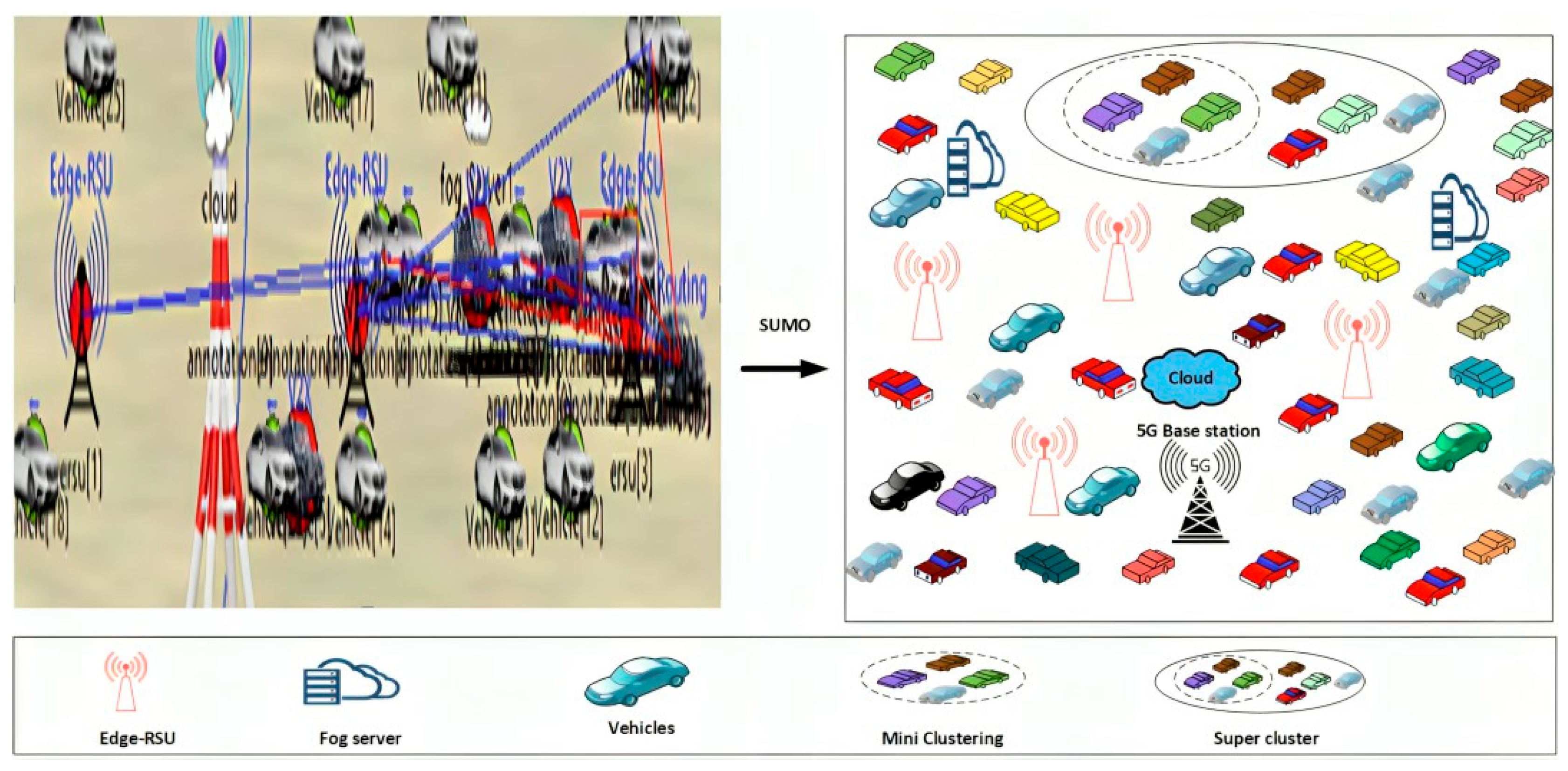
3.1. 2D with 3D Grid-Based Network Construction

The cloud-based VANET was initially established within a structured 2D and 3D grid framework. This grid divides the network into manageable m*m grid segments, resulting in reduced complexity and enhanced scalability. Within this grid selection, strategic deployment of both the base station (BS) and edge-assisted roadside units (Edge-RSUs) optimizes coverage and connectivity. Each grid is equipped with Edge-RSUs to efficiently harness vehicle interactions within their coverage areas, facilitating information transfer to the mini lanes situated within each grid. Furthermore, this architecture promotes direct communication between vehicles (V2V), vehicles and infrastructure (V2I), and vehicles and pedestrians (V2P), effectively mitigating communication overhead. By adopting this 2D and 3D grid network construction approach, the system significantly reduces the burden of high communication overhead, resulting in a more streamlined and efficient VANET infrastructure.

3.2. Energy Saving-Based Super-Clustering

To increase communication scalability and reliability, clustering is conducted after network creation. The number of cars grouped within the grid increases as the number of vehicles in this network increases. The fog nodes cluster the vehicles using the modified density peak clustering method (MDPC). Clustering increases network connectivity, energy efficiency, effective topology management, and minimizes latency. According to the suggested study, the vehicle is grouped according to its distance, node positions, energy, stability, velocity, degree, and dependability.

Fog Node Location Model

Fog nodes, which are often located inside the transportation infrastructure, provide a distributed computing architecture for optimizing clustering operations by being strategically positioned close to the edge of the network. This approach reduces the need to transfer massive volumes of raw data to a central data center or cloud for processing. Rather, fog nodes enable the local and real-time execution of the vehicle-network-suited MDPC clustering technique. Fast decision-making is made possible by automobiles moving across the network, which is crucial for communication and security. Additionally, fog nodes reduce network traffic by only transmitting pertinent cluster information, conserving bandwidth. The scalability, adaptability to changing network conditions, and independence in the case of network failures all contribute to the reliability of clustering operations. In in-vehicle networks with limited energy supply, these nodes may also be modified for energy efficiency. By providing automotive networks with the processing power required for quick, dependable, and efficient clustering via MDPC, fog nodes provide enhanced network scalability, communication, and performance in dynamic vehicle situations.
Each item designated as i in a fog computing environment with ‘n’ objects needs certain computing resources, C R i , and storage resources, S R i , in order to meet the service requirements. It is presumed that all entities may be serviced by a given number of virtual fog nodes, V, and have a shared maximum response latency, represented as M R e s . Every virtual fog node, represented as F n o d , has W distinct device types attached to it, represented as K d e v .   Q V w denotes the unique number of each device type, K d e v V w , within these devices. Within this collection, a specific device is denoted as d e v V w j , where j denotes the device type index and m denotes the device type. R e s v w j i denotes the service delay for each item i where the jth device of type w serves that object. Furthermore, the unit resource costs are represented by the notation C o s t v w j = { C o s t S v w j , C o s t C v w j } and R e v w j = R e S v w j , R e s C v w j , where C o s t S denotes the cost of storage resources, R e S , and C o s t C denotes the cost of computation resources, R e C . These expenses are related to the type w gadget j. The following formula may be used to construct the fog node placement and allocation problem:
M i n :   K 1   v = 1 V w = 1 w j = 1   Q V w i = 1 n R e s v w j i x i + K 2   v = 1 V w = 1 w j = 1   Q V w C o s t v w j R e v w j .
s . t .     x i = 1 ,   i f   T h i n g   i   i s   s e r v e d ,   o t h e r w i s e , x i = 0           R e s v w j i M R e s                                                                                                                               v = 1 V w = 1 w j = 1   Q V w C o s t v w j R e v w j i = 1 n ( S R i + C R i ) .
If there are ‘n’ points in an Euclidean space, and each point represents a “Thing,” then the resources needed to service each Thing and the related resource prices are regarded as characteristics of these points. Subsequently, the points are arranged into clusters by minimizing the weighted distance between the points and the centers of each cluster. To guarantee that the distance between each point and its cluster centroid stays below a certain threshold, a constraint is also applied to these clusters. The following may be used to summarize this clustering process:
M i n :   K 1 i = 1 W j = 1 W d j y i j C o s t i x i + K 2 i = 1 W j = 1 W Q i j y i j                                      
  s . t .     x i , y i j   0,1 Q i j = d i O i j Q i j O T h r
The weights of the items are represented by K 1 and K 2 . The selection point as a virtual fog node is denoted by x i , and the quality of service provided by point j or Q i j O T h r is shown by y i j . Q i j represents the quality of service provided by point j to point i . It is a measure of how well point j serves point i in the context of the network. The service delay occurs when fog node i serves point j. O T h r denotes the value at the threshold.
  • Modified density peak clustering (MDPC) algorithm.
The MDPC method uses a local reachability density-based clustering strategy to improve clustering performance. The cluster head selection step of the procedure comes after the clustering phase.
Cluster centers are identified by their greater density relative to nearby data points and by their relative distance from other places with higher densities. This denotes the foundation upon which the MDPC algorithm functions. For each data point, two crucial features are defined, (1) σ i and (2) τ i , in order to capture these qualities. Inherent to the clustering technique are the following qualities:
  σ i = j = 1 n A d i j d C .
τ i   for a data point σ i denotes the minimum distance to any data point τ j with a higher local density ( σ ) than σ i , but only if the stated cutoff distance d C is met or exceeded by the distance d i j . A represents an indicator function that determines if a given distance meets this condition:
τ i = M i n ( d i j ) M a x ( d i j )         i f   j ,   s . t : σ j > σ i i f   j ,   s . t : σ j < σ i
The number of data points closer to point i than a certain distance, d C , is represented by σ i . This metric offers a localized view of the probability that point I will function as a cluster center. Conversely, τ i denotes the minimal separation between point i and its closest high-density point, providing a worldwide view of the probability that point i is a cluster center. Metrics like σ i and τ i are widely used in practice to identify various properties of clusters. Usually, cluster centers are selected at intervals when these metrics have high values. The remaining data points are then assigned to the closest cluster center in a single step once these cluster centers have been identified, ensuring accurate cluster assignments. By considering both local and global density features, this method provides a data-driven method for choosing cluster centers, which enhances the accuracy of the clustering process. The supercluster idea is shown in Figure 1.
Following the first cluster center identification, the slave cluster heads (SCHs) must be selected. This selection process takes into account many aspects to provide the greatest possible selection of SCHs. Density, packet delivery ratio, energy level, capacity, and distance are some of these characteristics. By considering these factors, the clustering algorithm seeks to maximize the efficacy and efficiency of the cluster head selection procedure while choosing SCHs. The SCHs are better suited to their duties in the network as a result of this rigorous evaluation of several elements.
A supercluster was overlaid with small clusters as part of the proposed methodology. We see the supercluster diagram in Figure 2. Slave CHs in mini-clusters collect data from nodes and forward them to the super CH via a hierarchical structure. Slave CHs also transmit data to a nearby node. This allows the network to function in a multi-hop fashion. Furthermore, a slave CH takes on the role of the cluster head as the energy of the slave node is larger than that of the cluster head. When processing the SCH proves difficult and a cluster could accommodate many vehicles, cluster splitting is used. When two clusters have a dense vehicle with identical properties, cluster merging is used. The network was also connected to fog nodes, which provided faster data processing and less energy use. We will now analyze the temporal complexity and frequency of executing the proposed MDPC (multi-hop delay propagation calculation) and best forwarder selection algorithms concerning vehicle density. Single hop delay: Since this is a straightforward division, we will assume that it is O ( 1 ) . Since the multi-hop delay calculation is a O ( n ) process that entails iterating over n regions and calculating delays, the total time complexity of the MDPC is O ( n ) . Execution frequency: Higher densities may need more frequent estimates due to variable traffic patterns, depending on the number of cars.

3.3. Hybrid Protocol-Based Path Selection

After successful clustering, optimal path selection is performed to develop the dissemination of EMs. The entire car is equipped with a GPS, which uses the vehicle ID to pinpoint the position. Every time a vehicle enters one of the road segments, the Edge-RSU with gateway captures information on the vehicle and the road. The UMBBFS hybrid protocol was applied to improve the performance of multi-hop broadcasts and the selection of the best forwarder, with a focus on reducing one-hop delay, increasing message propagation speed, and enhancing the message reception rate when determining the optimal path.

Urban Multi-Hop Broadcast and Best Forwarder Selection (UMBBFS) Protocol

In an urban environment, the UMBBFS employs an emergency message transmission protocol for traffic accidents occurring on either straight roads or intersections. If the root of the path is straight, the message starts broadcasting in both directions and a communication channel is selected to send the message. However, when the destination’s source is at the intersection, the message multicasts in many directions, and there is still a relay node on each branch. In subsequent hops, the message is at an intersection, where multi-directional broadcasting may occur. This protocol efficiently disseminates emergency messages in the urban context, optimizing message propagation based on the source node location and minimizing redundancy in message relay. When an emergency message needs to be transmitted, the UMBB quickly selects neighboring nodes in multiple directions.
  • Multi-hop broadcast.
Using GPS location and digital maps allows the source of the location and its neighbors to determine whether they are in the intersection area. When an incident occurs at the intersection, UMBB begins broadcasting various announcements during the first half of the broadcast. This allows emergency information to be displayed on all side roads starting from the intersection, solving the problem of black area interference between adjacent lines in multiple directions. At an intersection, preventing ‘blacks’ from colliding by interacting with nodes at the intersection is a challenge that must reach those adjacent to the intersection, especially in cases when the ‘black’ is broken. Figure 2 illustrates the multi-hop broadcast architecture
In the context described, the source node is denoted as ‘T’, while the neighboring nodes ‘P’, ‘Q’, ‘R’, and ‘S’ are situated in various directions at intersection point ‘O’. When node ‘R’ sends a black-burst transmission along one road toward source node ‘T’, it can potentially result in interference with neighboring nodes located between ‘T’ and ‘O’ on different intersection roads. To address this issue, UMBB adopts an innovative method to control the transmission of black-burst signals among neighboring nodes situated on distinct roads within the intersection area.
2.
Neighboring nodes on the intersecting road.
The UMBB protocol implements an iterative process for nearby nodes on the crossing road, which is quite different from the process used for surrounding nodes on the current route. Prior to starting the road, two distances must be calculated: “r” denotes the distance from the center to the junction, and “d” denotes the distance from the source node to the intersection. The covered length of the intersecting road by the source node is represented, and half of this length is represented as c r , which can be calculated as c r = r 2 d 2 , as illustrated in Figure 3. The first iteration begins after a specific time interval, T I + 2 n + 1 τ . During this process, c r is initially divided into two segments: a forward area represented as f a 1 β c r , c r ) and a non-forward area represented as N F 0 , 1 β c r ) , in every direction of the intersecting road.
This segmentation and timing strategy helps manage the selection of forwarding nodes in a way that minimizes interference and minimizes message propagation in the complex urban communication environment described.
3.
One-hop delay in multi-direction.
One-hop delay is made up of many elements, such as the time needed to send an EM, the time needed for the iteration process, and the contention time needed to transmit a μ R. The time to transmit an EM is calculated as M i n i _ W C / 2 + T E , and the time is as T s + ( 4 n + 2 ) τ . The contention process requires the candidate to select a mini-slot to send EM packets through the contention window (CW) by sending nodes along the current path. The candidate’s chance of applying to the selected mini-hole is p = 1 / C W . If there is no conflict among candidates at two intersections, we can use a two-way broadcast to calculate the conflict time. We replace the “R” span in the current path. The length of the intersection in two directions is expressed as c r and can be calculated as c r = R 2 + r 2 ; where “r” denotes the distance between the center and the intersection. In the final analysis, potential forwarding nodes on the present path select mini-slots for EM transmission with a probability “p”. During contention, a bi-directional broadcast-like approach is utilized to calculate the contention time and one-hop delay on the present route when candidate nodes on adjacent roads are not in contention. Considering the distance “r” between the source node and the junction point, the covered length of the crossing road is c r . Divide the length c r into n segments, one for each direction of the intersecting road, such that the segments constitute the state space of the final f a . The state may be represented by the set, as follows:
SP = { S P 0 ,   S P 1 , . , S P n 1 }
The length of the I is denoted as follows:
S P I = 1 β j β ( n j ) c r ,             j   ϵ   0 , n
In segment S P I , Y i represents the number of candidates forwarding nodes. For probability, P t ( Y i = k ) . Our technique yields the one-hop delay on the intersecting route, indicated as   B H D M i . The average one-hop latency in multi-hop is calculated by using the mean of   B   H D M = ( B H D M c +   B H D M i ) /2.
Message propagation speed: The speed at which the EM spreads is measured by the distance traveled per second. This speed can be calculated by dividing the distance from destination to destination ( f a ) by the single hop delay. Finally, f a is expressed as I i 0 < i n 1 , which means that there are no cars in the region I 0 ,   I 1 , I i 1 . The probability of occurrence can be expressed as the product of the probability of each region. Therefore, the average one-hop propagation distance in the broadcast denotes “a”, as follows:
a ¯ = ( j = 0 i 1 h r ( x j = 0 ) h r ( x i = 0 ) ) .
The average one-hop propagation distance a is influenced by the chance that there are no automobiles in the zones from I 0 to I i , as represented by this equation:
  D B = ( 1 h r x 0 = 0 · M = i n 1 I M + i = 1 n 1 ( ( 1 h r x i = 0 j = 0 i 1 h r ( x j = 0 ) ) · M = i n 1 I M .
And the propagation speed is as follows:
P N = D B   B   H D D
In the context of a bi-directional broadcast, the emergency message is disseminated in two opposing directions, resulting in the propagation speed being influenced, as follows:
P O = 2 D B   B   H D O
In a multi-directional broadcast, where each direction on an intersecting road is covered up to a length of I R , the average per-hop distance in one direction can be calculated as follows:
D m = ( 1 h r y 0 = 0 ) · M = i n 1 R M i = 1 n 1 ( ( 1 h r ( y i = 0 ) j = 0 i 1 h r ( y j = 0 ) ) · M = i n 1 R M
Multi-directionally broadcasting the propagation speed is as follows:
S N = 2 D B + D L   B   H D P
The message propagation speed for each broadcast is finally determined.
4.
Best forwarder selection.
In this section, we introduce an effective approach for the best forwarder selection in VANETs. The forwarding node choice takes into account the priority assigned to the packets in its transmission queue. The primary goal is to reduce delay for EM transmission while also minimizing the routing overhead cost function that guides the selection of forwarding networks. This function considers two key metrics: delay and stability, as elaborated upon in the subsequent subsection.
Delay: The end-to-end delay (E2E) of a packet denotes the total time it takes for a packet to travel from its source to its destination, which in this case is node X. To calculate the link delay between two nodes, labeled as N i and N j , and represented as I D i , j for the link (i,j), we consider the following factors: transmission delay ( F t d ) , queuing delay ( Q d ), and hopping delay ( H d ).
In essence, the link delay I D i , j for the link between nodes N i and N j can be expressed as the sum of these individual delays:
I D i , j = F t d i + Q d i + H d
This calculation helps in understanding the total delay experienced by a packet as it travels through the network between the specific pair of nodes, N i and N j , where F t d i = C i D R and Q d i = C i D R C i , with D R denoting the data rate and C i illustrating the current buffer occupancy of N i to X, denoted by D i , and written as follows:
D i = ( i , j ) p a t h i I D i , j .
  p a t h i illustrates the routing path from N i to X.
Stability: To determine the connection security between two adjacent devices in VANETs, our approach uses a random waypoint model to introduce movement patterns in VANETs. In this VANET environment, each vehicle maintains a forum that records the distance measurement history of other neighboring vehicles in the time interval [0, t]. Using this historical information, the vehicle calculates the link stability at the current time, taking into account the distance traveled to all neighboring vehicles. The stability of the link between two nodes labeled N i and N j can be expressed as s i , j , given as follows:
s i , j = 1 M 1 T = 1 T M D i , j m e a n ( T ) 2 .
D i , j : Distance between two nodes;
N i and N j : Nodes at the current time;
m e a n T : The mean of M-previous distances between N i and N j , which is defined as follows:
m e a n T = T = 1 T M D i , j ( T ) M
The parameter s i , j in Equation (16) represents the standard deviation, which is an indicator of the coefficient of variation. It provides a standard measure of how data points are distributed in terms of probability. When the value of s i , j is close to 0, it means that the connection between two nodes is stable, and we can consider j as a stable neighbor of i. On the contrary, if D i , j ( T ) tends to 1, it means that the distance distribution is unstable and the connection between nodes is unstable.
In the tuning-based forwarder selection approach, each node N i with high-priority data packets ( H p ) to send makes its forwarder choice based on the priority of these packets in its transmission queue. We devised a cost function that takes both delay and stability into account. Let   N f i , j represent the cost of selecting downstream N j as the forwarder from the perspective of N i . To give relative importance to these metrics, we assign two weights, α and β, respectively. The cost function is calculated as follows:
N f i , j = α × D j + β × s i , j
α + β = 1
When N i intends to transmit a packet, it seeks to minimize delay. Therefore, it calculates the cost value N f i , j for each N i N l i , as specified in Equation (18), by assigning a higher weight to delay. The node selects the forwarder with the lowest cost as the optimal choice.
Conversely, if the node holds a low priority ( L p ) packet in its buffer, it prioritizes a stable forwarder to relay the data and reduce routing overhead. In this case, it increases the weight associated with stability in the cost function in Equation (18) and selects the CR with the minimum cost as the forwarding node. For instance, we can set α = 0.4 and β = 0.6 for L p data. The tuning-based forwarder selection, based on the packet type in the transmission queue, is presented in Algorithm 1.
Algorithm 1: Best forwarder selection algorithm
Input: List of requesting nodes ( N i ) , forwarder list N l i ,
i M
Output: Forwarder of N i
1: Find N l i , for each i M
2: Calculate delay D j , for each N j N l i
3: Calculate stability s i , j , for each N j N l i
4: if ( N i has H p packets to send) then
5:   {
6:   for every j N l i , compute N f i , j by providing high weight   to α   a n d   β
7:   forwarder N i = min j Nl i N f i , j
8:   }
9: end if
10: if ( N i has L p packets to send) then
11:    {
12:     for each j N l i , compute N f i , j by providing a higher
            weight to β   t h a n   α
13:     forwarder N i = min j Nl i N f i , j
14:    }
15: end if
5.
Improved firefly optimization (IFO) algorithm.
The improved firefly optimization algorithm operates under the premise that all fireflies are unisex and attract each other. Attractiveness depends on the brightness and distance between the fireflies. Brightness is directly proportional to attractiveness, while distance has an inverse proportionality. Therefore, one firefly moves toward another based on the strength of attraction between them. To facilitate optimization, there is a specific entry for the objective function in a sorted list. The primary objective is to maximize this objective function value. In the context of this algorithm, the objective function value is computed at each vehicle node, serving as a measure of the quality of a given solution. This objective function value guides the movement of the fireflies as they attempt to improve their solutions by gravitating toward brighter, more attractive fireflies, while taking into account the distance between them. This process continues iteratively, and the algorithm aims to converge toward a solution that maximizes the objective function value, thereby optimizing the desired transmission.
α = α 0 e β
where α illustrates the brightness, β is referred to as delay, and α 0 denotes the initial value. So, the improved objective function (the movement of the x th node to another node y th) is defined in Equation (21), as follows:
α t = α + A x A y   β + μ
where
μ = μ f ( 1 d / μ j )
d = density, μ f denotes free flow speed, μ j denotes traffic density associated with completely blocked traffic, and A x A y denotes the cartesian distance between the x th and y th node.
The selection criteria for this objective function are rooted in the dynamic nature of the problem, where vehicles exhibit varying speeds and travel in diverse directions. To adapt to these dynamics, the objective function assesses the distance between each vehicle and a stationary reference point, usually the origin. This distance assessment occurs in two dimensions, effectively capturing the Cartesian distance between each vehicle’s current location and the stationary reference point. By considering both horizontal and vertical separations, the algorithm can gauge how effectively each vehicle is positioned within the problem space. The central aim is to optimize the objective function value for each vehicle. Given the ever-changing positions of vehicles in relation to one another, this objective function provides a dynamic measure of how well each vehicle is situated. The reason for adopting the IFO algorithm is to solve complex tasks simply, leading to easy adaptability, robustness, and scalability. Figure 3 presents the improved firefly optimization architecture.

3.4. DRL-Based Emergency Message Dissemination

After path selection, the destination area is selected to disseminate the emergency message using the improved twin delay deep deterministic policy gradient algorithm (IT3DPG) based on the direction, number of vehicles per lane, number of vehicles crossings, and packet transmission. In these situations, the IT3DPG algorithm tackles the issues of slow convergence and poor training efficiency, offering significant benefits in continuous control problems.

3.4.1. Delay Deep Deterministic Policy Gradient Algorithm

In this section, we present the adaptation of the delay deep deterministic policy gradient algorithm for path selection in VANETs to facilitate the efficient dissemination of Ems. Our two-stage system uses twin-actor networks for policy learning to improve decision accuracy. The agent first interacts with a VANET simulation to acquire the optimal route selection technique and train twin-actor and critic networks offline and online. Subsequently, during the online phase, these networks are adapted, providing a warm startup that improves operations, including EM dissemination, aiming to enhance communication safety and effectiveness in vehicular networks.
This process begins with pre-trained message actor and critic models that have learned from historical data encompassing past emergency message transmissions. The historical data serve as repositories, containing sender vehicle information, message type, urgency, and subsequent vehicle states. When a vehicle node sends an emergency message, message actor networks generate and transmit a message action, triggering state changes and potential responses from other vehicles. Transmitted messages are recorded as transitions during the experience replay memory. During the EM process within the network, the message actor networks operate in a closed-loop manner. They start by receiving the current state ( C s ) from the vehicle’s communication system and then determine the appropriate action (A) to take. This action is subsequently sent out via the communication network, leading to a change in the system’s state ( S s ) and the reception of a reward (R) associated with the action taken. Each message transition is recorded and added to our experience replay memory ( E 2 ). To enhance the reliability of message delivery, we periodically extract a random batch of these message transitions (consisting of the state, action, reward, and subsequent state) from our experience replay memory. These subsequent states ( S s ) are provided as inputs to target message actor networks, which predict the best possible actions ( P A ) based on these states. Furthermore, the predicted target actions and corresponding states ( C R S ) are forwarded to target message critic networks to estimate their quality and evaluate how likely they are to effectively reach the intended recipients.
This evaluation produces the ultimate goal value, F T V , of each message transition, which denotes the critic network’s minimal projected future reward and past reward. The message critic networks construct current Q-values using the starting state ( I S ) and action from the sampled batch of data i. The F T V and current Q-values are utilized to calculate a loss and update the message critic networks. We create two sets of actor networks: the primary actor networks, denoted as A N 1 , and their corresponding target actor networks, denoted as A N T 1 , along with a second pair of primary actor networks, A N 2 , and their corresponding target actor networks, A N T 2 . These networks are equipped with the following distinct sets of parameters: ϕ A N 1 and ϕ A N 2 for the primary actor networks and ϕ A N T 1 and ϕ A N T 2 for the target actor networks. To initialize the target actor networks, we set the parameters of ϕ A N T 1 equal to ϕ A N 1 and ϕ A N T 2 equal to   ϕ A N 2 . This initialization process helps ensure a smooth and stable learning process to optimize the dissemination of emergency messages within VANETs, allowing the target actor networks to progressively adapt to the evolving communication environment.
( ϕ A N T 1 ϕ A N 1 )   and   ( ϕ A N T 2   ϕ A N 2 )
We built two critic networks and initialized them with parameters ϕ C N 1 and ϕ C N 2 . The corresponding target networks are defined as ϕ C T N 1 and ϕ C T N 2 . We initialize the target network as follows:
(   ϕ C T N 1 ϕ C N 1 )   and   ( ϕ C T N 2 ϕ C N 2 )
Notice the initial state, I S , and select action A S from the actor network with noise added to the action.
A S i = c l i p μ A N i I S + , A S m i n ,   A S m a x ,   i   ϵ   { 1 ,   2 }
The parametrized deterministic policy in this case is denoted as   μ ϕ A N i , and the upper and lower boundaries of action are denoted as A S m i n   a n d   A S m a x , respectively. We select a course of action to maximize the Q function as follows:
AS = arg max AS i Q ϕ C N j   ( I S ,     A S i ) ,   i ,   j   ϵ   { 1 ,   2 } i   ϵ   { 1 ,   2 }     j   ϵ { 1,2 }
The state, S, and the target action, TA, are given as input to the target Q-network to estimate the target Q-value, Q ϕ C T N 2 (S, TA). We select the minimum of the two Q-values to calculate the target value, TV, given as follows:
T V = α min Q ϕ C T N j   ( S ,   T A ) ,   j   { 1 ,   2 }
The proposed work adopts the intelligent transportation system (ITS) with two specific systems, namely, the traffic management system (TMS) and the intelligent traffic light (ITL) system. However, smart transportation is an advanced system that offers new services related to different types of transportation and traffic management, allowing users to better understand and use transportation better, in a more integrated and smarter way. Then, emergency messages can be classified into four categories, as follows: road event notifications (i.e., accidents, abnormal vehicles), ambulance alerts, nearby pharmacies, and public works using a light gradient boosting machine (LGBM) algorithm via fog nodes.

3.4.2. Light Gradient Boosting Machine (LGBM) Algorithm

A light gradient boosting machine, which is an ensemble algorithm rooted in decision trees, leverages a forward distribution approach. In each iterative step, it fits the message data by considering the negative gradient, essentially training a decision tree. The initial step involves preparing a training dataset, denoted as T D = { x i ,   y i } i = 1 N , where i ranges from 1 to N, signifying N message samples. Each x i represents a multi-dimensional input vector of dimension M, i.e., x i     R M × 1 , while y i   R corresponds to a single numerical target value. Specifically, M is computed as M = n t w × n s m + n r t , where n t w represents the time window size, n s m denotes the number of selected message features, and n r t reflects the runtime nodes. y i   ( i = 1,2 , 3 , ,   N ) is a one-dimensional target value. Within this ensemble of decision trees, the predictions from all the individual trees are combined to effectively categorize and process the incoming emergency messages:
y i ^ = k = 1 k t k x i ,   t k   T   .
Here, k represents the number of trees, T denotes the space that encompasses all conceivable tree structures, and t k represents a particular tree within this space, complete with its associated EM scores. t k is derived by minimizing the objective, as follows:
t k = arg min t k i = 1 N T l   ( y i ,   y i ^ ( k ) ) + Ω ( t k ) .
where T l denotes the training loss function and Ω denotes the regularization function, usually defined by Equation (29).
Ω t k = α E M + 1 2 λ   j = 1 E M ω j 2 .
Here, α denotes the penalty parameter for the number of EMs and ω denotes the weight of the EM. When EM uses a squared error loss function, its loss is calculated as follows:
E M y , y ^ ( k 1 ) + t k x = y y ^ k 1 t k x 2 = r t k ( x ) 2
t k is obtained by fitting the residual r.
t k arg min t k i = 1 N [ t k ( x i ) + 1 2 t k 2 x i ] + Ω t k .
Therefore, a new tree is obtained by minimizing this objective function. Furthermore, the emergency messages of road event notifications and public works are controlled by ITL, and ambulance alerts and nearby pharmacies are controlled by TMS. Here, the LGBM model has the advantage of having a fast training speed, which is suitable for handling large-scale data, and it also has high classification accuracy. In this way, all emergency messages are quickly disseminated in multiple directions and can manage the traffic in the VANET.

4. Experimental Results

The experimental examination of the proposed super-clustering-based UMBBFS routing protocol for the EM dissemination method is shown in this section. The results show that the suggested technique is quite effective. This sub-section includes the simulation setup, comparison analysis, and research summary.

4.1. Simulation Setup

This sub-section explains the simulation setup and environment for the super-clustering-based UMBBFS routing protocol for EM dissemination. This proposed approach experimented with a simulation environment of 2750 m × 2250 m. Table 1 presents the system configuration.
The proposed work was simulated using the Objective Modular Network (OMNET++) and Simulation of Urban MObility (SUMO) simulation tools, where ++ denotes that the OMNET environment used C++ for testing. Table 2 presents the simulation configuration. Figure 4 presents the experimental simulation scenario.

4.2. Comparative Analysis

The proposed model is assessed by contrasting it with other existing strategies in terms of throughput, end-to-end delay, coverage, packet delivery ratio, packet received, and transmission delay.

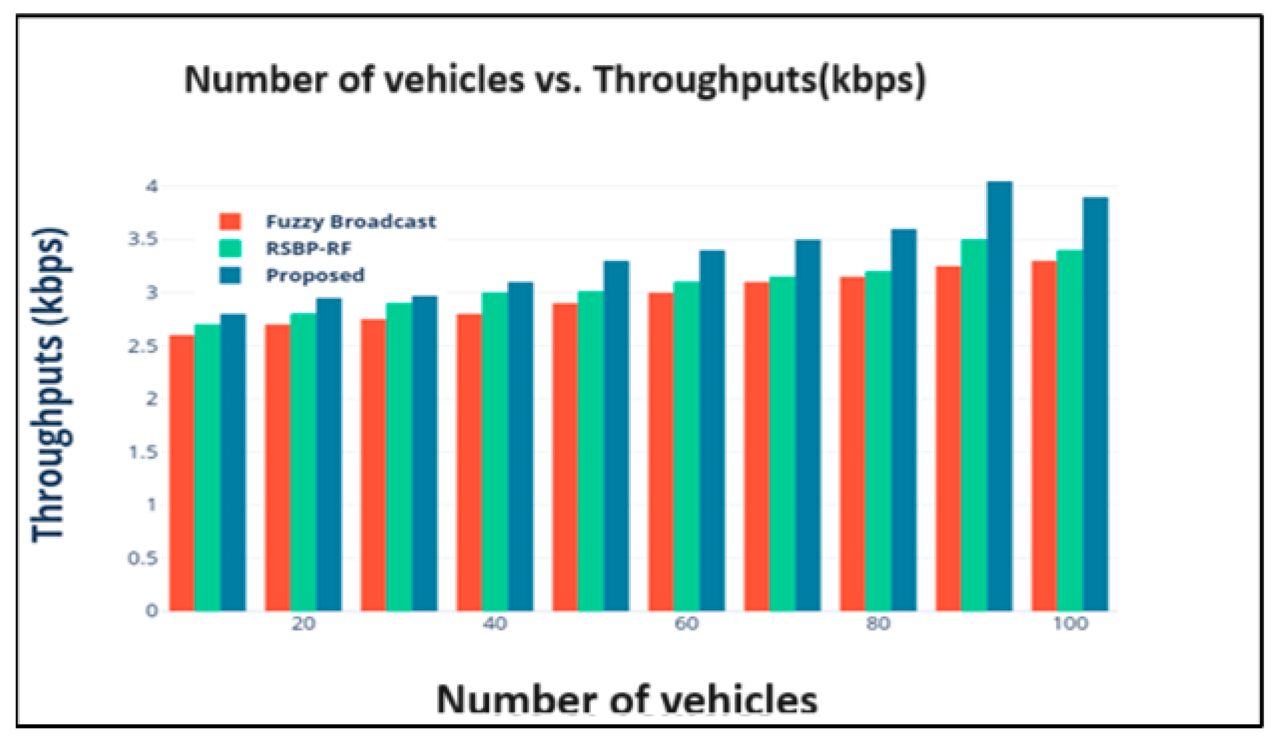
4.2.1. Number of Vehicles vs. Throughput

Throughput refers to the capacity of a transportation system to move vehicles through a given area. The concept of the number of vehicles vs. throughput can be defined using the following equation:
Q = f ( N ,   C ,   T ,   M )
where Q denotes the throughput (measured in message per unit time), N denotes the number of vehicles in VANETs, C denotes various cluster-related parameters, such as the cluster size or density, T denotes technology-related parameters, like the Edge-RUS density and 5G network capacity, and M denotes the message characteristics, such as the message size and urgency. Figure 5 shows the performance of the network throughput where the x-axis is assigned with the number of vehicles and the y-axis denotes the throughput value in kbps. The throughput for fuzzy broadcast is 3.3 kbps, while RSBP-RF achieves a throughput of 3.4 kbps. In contrast, the proposed method achieves a higher throughput of 3.9 kbps.

4.2.2. Vehicle Density vs. End-to-End Delay

The time taken by EMs to travel in a VANET model from the source vehicle to the destination vehicle is influenced by the vehicle speeds. At lower speeds, fewer vehicles carry data, resulting in higher end-to-end latency, as follows:
  D = A × 1 V d + B
D denotes the end-to-end delay (ms);
V d represents the vehicle density;
A and B are constants that depend on the specific network.
Figure 6 illustrates the performance of the network. In this figure, as vehicle density increases, the end-to-end delay tends to decrease, which means that EMs can be transmitted more quickly in denser traffic conditions. The end-to-end delay for multi-lane mmWave is 90 ms, whereas RSBP-RF achieves an end-to-end delay of 87 ms. In contrast, the proposed method demonstrates a significantly lower end-to-end delay, at just 70 ms.

4.2.3. Vehicle Density vs. Coverage

Vehicle density and coverage are two important factors in transportation and urban planning that have a significant impact on the traffic flow, accessibility, and overall efficiency of transportation systems. Figure 7 shows the correlation between vehicle coverage and density. Increasing the vehicle density leads to a shorter connection distance (d = λ − 1). Multi-lane mmWave technology achieves a coverage rate of 59%, RSBP-RF technology offers a coverage rate of 70%, and our proposed method stands out with an impressive coverage rate of 90%, showcasing its potential to significantly enhance network coverage and performance.

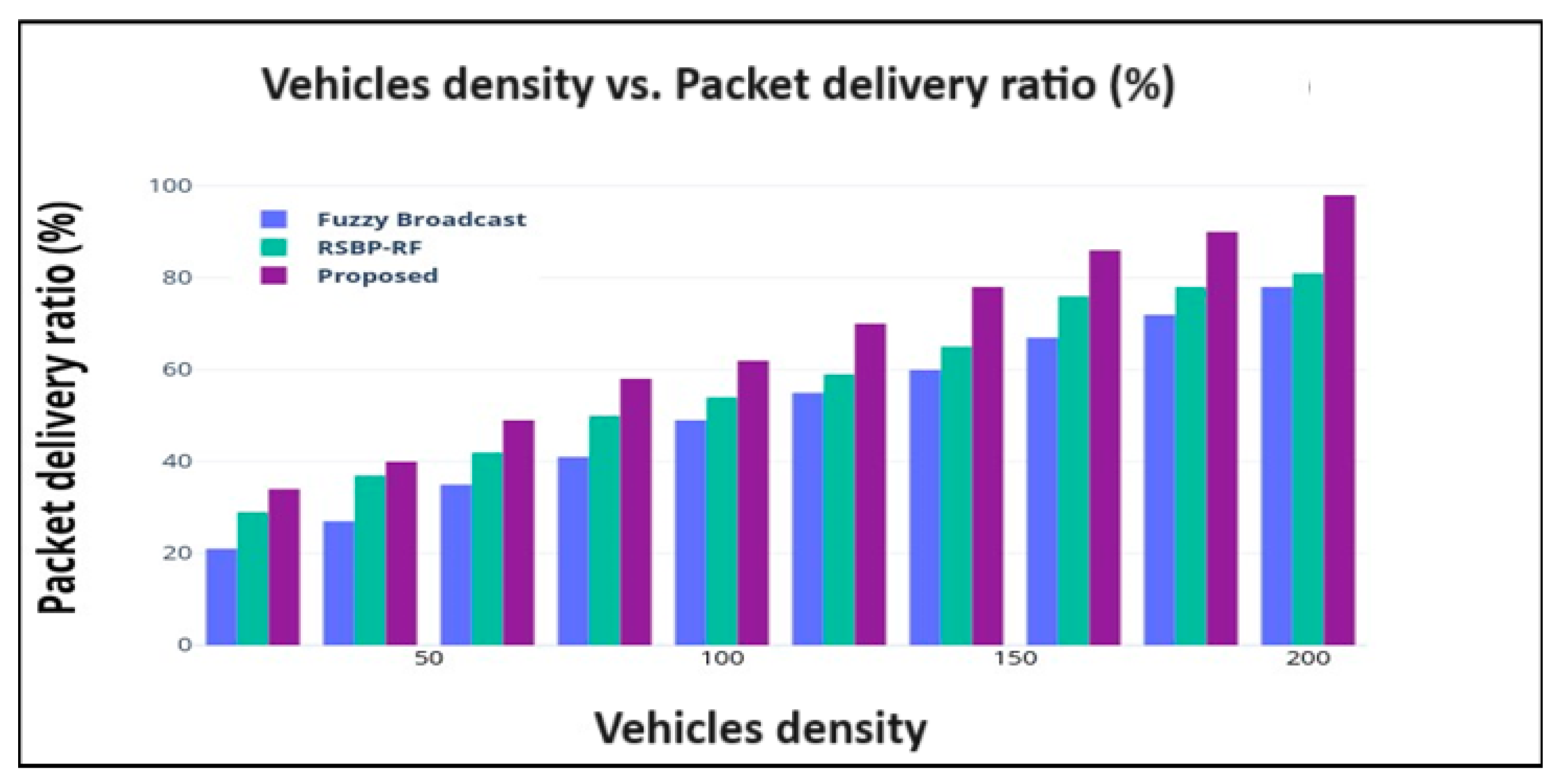
4.2.4. Vehicle Density vs. Packet Delivery Ratio

The packet delivery ratio is a metric used to measure the effectiveness of the data transmission system in VANET. The packet delivery ratio can be obtained by dividing the total number of packets arriving at the destination by the total number of packets sent from the destination.
P D R = N u m   o f   p a c k e t s   a r r i v e d   a t   d e s t i n a t i o n T o t a l   d a t a   p a c k e t s   s e n t   f r o m   s o u r c e
Figure 8 illustrates the performance of the packet delivery ratio in the network. The packet delivery ratio in the fuzzy broadcast is 78%, the packet delivery ratio in RSBP-RF is 81%, and the proposed method’s packet delivery ratio is 98%. A high packet delivery ratio indicates a more reliable network, which is essential for applications and services that require dependable data transfers.

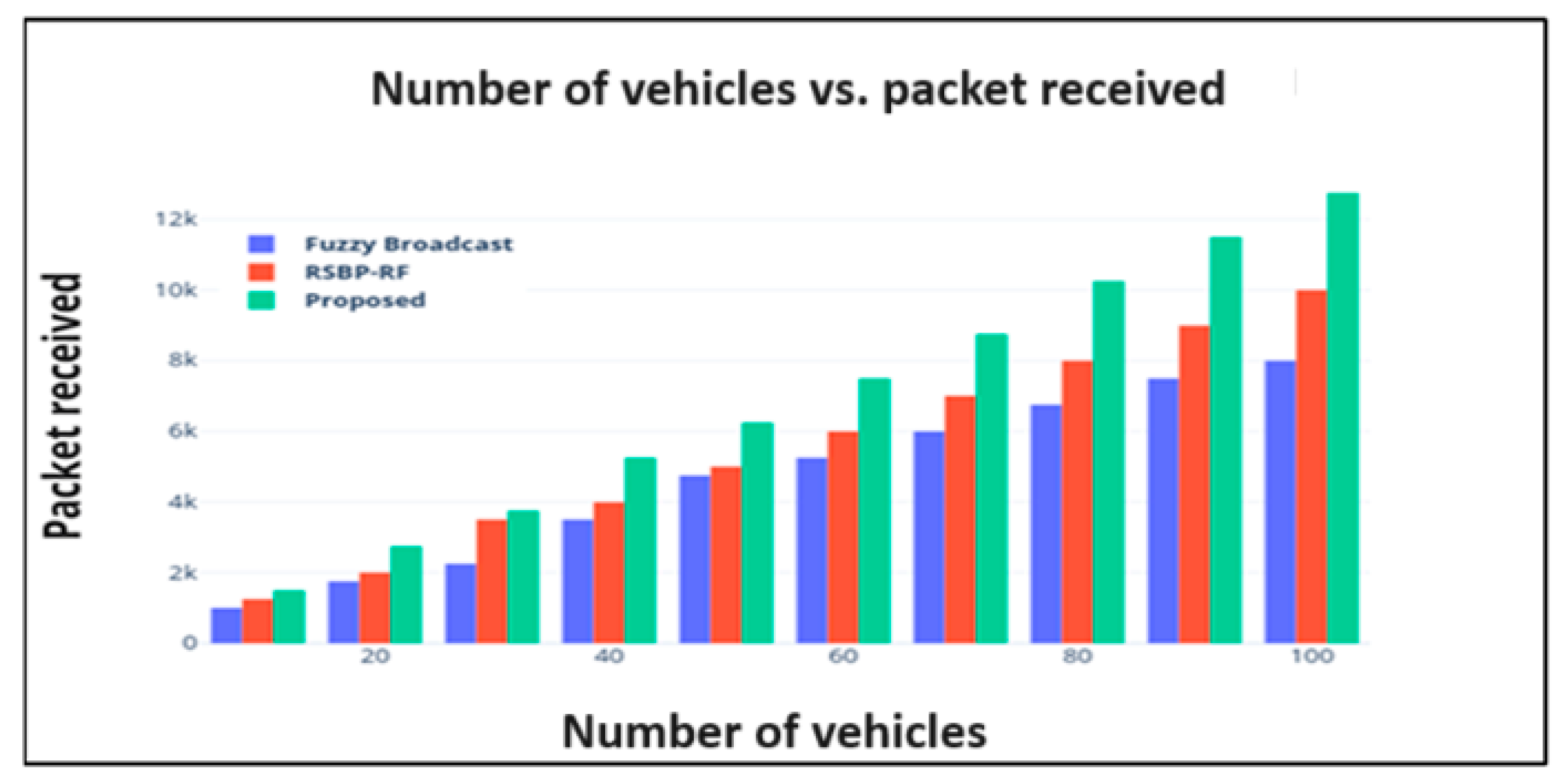
4.2.5. Number of Vehicles vs. Packet Received

The packet received refers to the successful reception or delivery of a data packet within a communication system. When a packet is transmitted from a sender to a receiver, it goes through various network devices and communication channels. A packet received event occurs when the recipient successfully receives and processes the incoming packet without any errors or loss of data.
P R = P S × P D R
P R denotes the packet received rate; P S refers to the number of packets sent from the source node; PDR indicates the packet delivery ratio in the network.
Figure 9 illustrates the number of vehicles vs. packet received rate. The findings of the comparison reveal that the suggested work outperforms comparable works. The packet received rate in RSBP-RF is 1 k, the packet received rate in fuzzy broadcast is 8 k, and the proposed packet received rate is 12.75 k.

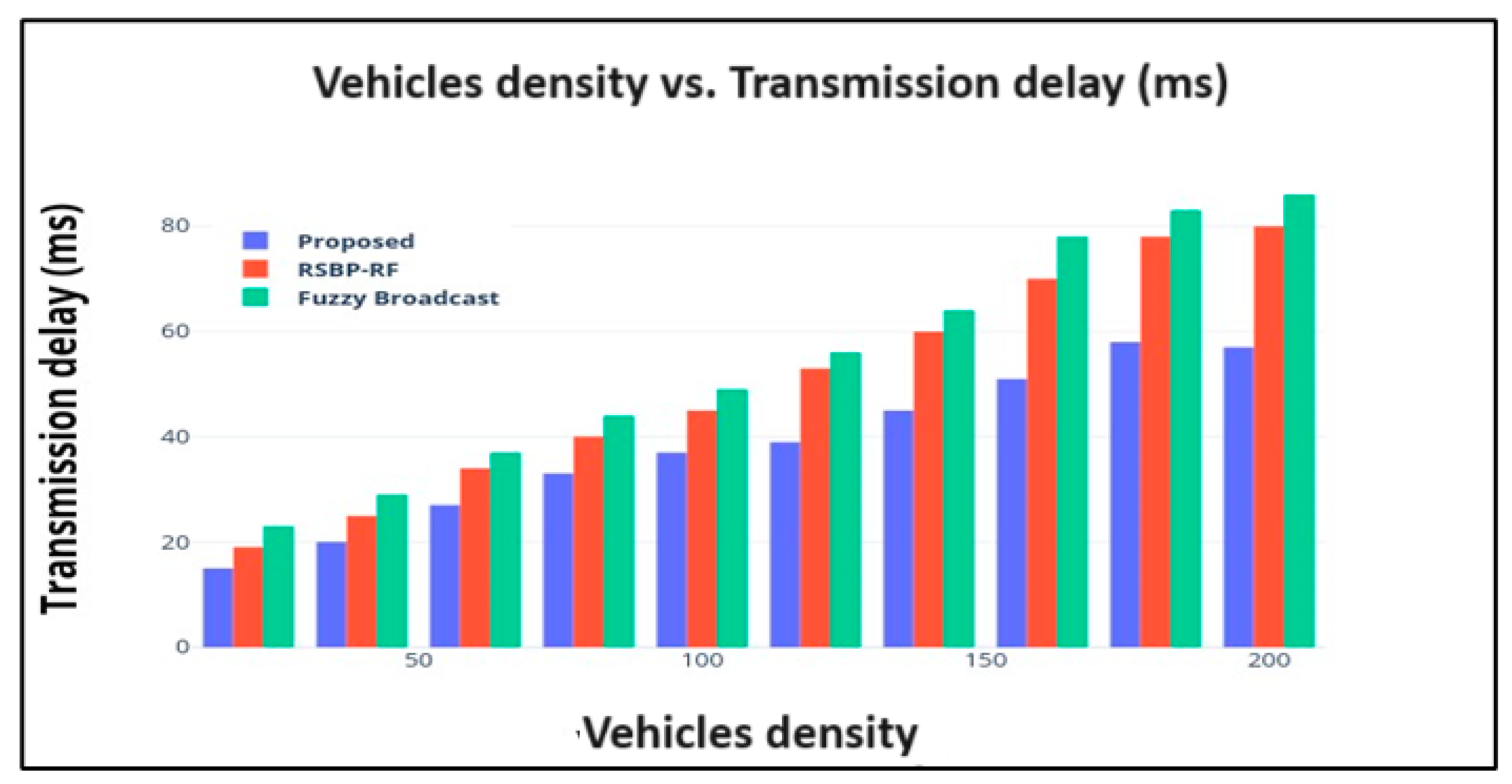
4.2.6. Vehicles Density vs. Transmission Delay

The concept of “vehicle density vs. transmission delay” can be performed using the following equation:
T D = P r o p a D + Q D + P r o D
Figure 10 illustrates the performance of transmission delay in the network.
Signal propagation delay ( P r o p a D ) denotes the time between the transmitter and receiver. It depends on the vehicle distance and light speed. Queuing delay ( Q D )   occurs when packets wait in a queue before transmission. The vehicle density affects network congestion. A vehicle’s processing delay ( P r o D )   denotes the time it takes to prepare a packet for transmission. The transmission delay in the fuzzy broadcast is 86 ms, the transmission delay in RSBP-RF is 80 ms, and our proposed transmission delay is 57 ms.

4.3. Research Summary

This section presents a summary of the findings of the experiments, demonstrating the improved performance achieved by the proposed framework. Figure 11 illustrates confidence intervals, the tasks completed as part of the proposed work are listed below: number of vehicles vs. throughput, vehicle density vs. end-to-end delay, vehicle density vs. coverage, vehicle density vs. packet delivery ratio, number of vehicles vs. packet received, and vehicle density vs. transmission delay, all which are described in Figure 5, Figure 6, Figure 7, Figure 8, Figure 9 and Figure 10. Table 3 shows the numerical analysis of the proposed and existing works, demonstrating the performance metrics.

Confidence Interval

The range of values that can be inferred from the sample statistics and is likely to include the value of an unknown population parameter is called a confidence interval; this range can be calculated using the following equation:
x ¯ ± z S n
Sample mean ( x ¯ ) 250, standard deviation ( S ) 80, sample size (n) 4, and confidence level 95% (confidence interval is 250 ±   78.4 or from 171.6 to 328.4).

5. Conclusions

This research aims to utilize the UMBBFS routing protocol to address key challenges in VANETs, focusing on reducing the packet loss, transmission delay, and network complexities through optimal routing and the best forwarder selection. Additionally, our study presents a comprehensive approach to enhance emergency message dissemination in 5G-enabled networks, leveraging advanced communication technologies, efficient fog and cloud resource management, as well as intelligent clustering and path selection techniques, with the primary goal of achieving rapid and reliable emergency communication. Our findings strongly suggest that this approach has significant potential to improve emergency response systems and enhance overall public safety. The proposed supercluster-based UMBBFS routing protocol model was verified with the help of the simulation tools OMNET++ and SUMO. Additionally, an assessment of the current technique was carried out by comparing it with existing approaches. The performance of the proposed approach was addressed using numerical analysis; using this analysis, we demonstrated that our method is superior to all other techniques currently available (in terms of all of the metrics). In future work, we plan to improve the robustness of the protocol against a variety of difficulties, including network segmentation, node failures, and changes in the dynamic topology. To ensure dependable message distribution under challenging circumstances, we will investigate fault tolerance, route repair, and adaptive routing strategies.

Author Contributions

Conceptualization, methodology, software, M.A.A.; validation, formal analysis, investigation, resources, data curation, S.A.; writing—original draft preparation, M.A.A.; writing—review and editing, H.M.; visualization, supervision, project administration, I.S. All authors have read and agreed to the published version of the manuscript.

Funding

This research received no external funding.

Data Availability Statement

Data are contained within the article.

Conflicts of Interest

The authors declare no conflicts of interest.

References

  1. Ullah, S.; Abbas, G.; Abbas, Z.H.; Waqas, M.; Ahmed, M. RBO-EM: Reduced broadcast overhead scheme for emergency message dissemination in VANETs. IEEE Access 2020, 8, 175205–175219. [Google Scholar] [CrossRef]
  2. Afrashteh, M.; Babaie, S. A route segmented broadcast protocol based on RFID for emergency message dissemination in vehicular ad-hoc networks. IEEE Trans. Veh. Technol. 2020, 69, 16017–16026. [Google Scholar] [CrossRef]
  3. Marques, M.; Senna, C.; Sargento, S. Evaluation of strategies for emergency message dissemination in vanets. In Proceedings of the 2020 IEEE Symposium on Computers and Communications (ISCC), Rennes, France, 7–10 July 2020; pp. 1–6. [Google Scholar]
  4. Ayaz, F.; Sheng, Z.; Tian, D.; Liang, G.Y.; Leung, V. A voting blockchain based message dissemination in vehicular ad-hoc networks (VANETs). In Proceedings of the ICC 2020 IEEE International Conference on Communications (ICC), Dublin, Ireland, 7–11 June 2020; pp. 1–6. [Google Scholar]
  5. Desai, D.; El-Ocla, H.; Purohit, S. Data Dissemination in VANETs Using Particle Swarm Optimization. Sensors 2023, 23, 2124. [Google Scholar] [CrossRef] [PubMed]
  6. Basha, S.K.; Shankar, T.N. Fuzzy logic based forwarder selection for efficient data dissemination in VANETs. Wirel. Netw. 2021, 27, 2193–2216. [Google Scholar] [CrossRef]
  7. Balamurugan, A.; Priya, M.D.; Malar, A.C.J.; Janakiraman, S. Raccoon optimization algorithm-based accurate positioning scheme for reliable emergency data dissemination under NLOS situations in VANETs. J. Ambient Intell. Humaniz. Comput. 2021, 12, 10405–10424. [Google Scholar] [CrossRef]
  8. Rehman, O.; Ould-Khaoua, M. A hybrid relay node selection scheme for message dissemination in VANETs. Future Gener. Comput. Syst. 2019, 93, 1–17. [Google Scholar] [CrossRef]
  9. Moni, S.S.; Manivannan, D. A scalable and distributed architecture for secure and privacy-preserving authentication and message dissemination in VANETs. Internet Things 2021, 13, 100350. [Google Scholar] [CrossRef]
  10. Rizwan, S.; Husnain, G.; Aadil, F.; Ali, F.; Lim, S. Mobile Edge-based Information-Centric Network for emergency messages dissemination in Internet of Vehicles: A Deep Learning Approach. IEEE Access 2023, 11, 62574–62590. [Google Scholar] [CrossRef]
  11. Chakroun, R.; Abdellatif, S.; Villemur, T. LAMD: Location-based Alert Message Dissemination scheme for emerging infrastructure-based vehicular networks. Internet Things 2022, 19, 100510. [Google Scholar] [CrossRef]
  12. Selvi, M.; Ramakrishnan, B. Lion optimization algorithm (LOA)-based reliable emergency message broadcasting system in VANET. Soft Comput. 2020, 24, 10415–10432. [Google Scholar] [CrossRef]
  13. Alghamdi, S.A. Novel path similarity aware clustering and safety message dissemination via mobile gateway selection in cellular 5G-based V2X and D2D communication for urban environment. Ad Hoc Netw. 2020, 103, 102150. [Google Scholar] [CrossRef]
  14. Ramya Devi, M.; Jasmine Selvakumari Jeya, I.; Lokesh, S. Adaptive scheduled partitioning technique for reliable emergency message broadcasting in VANET for intelligent transportation systems. Automatika 2023, 64, 341–354. [Google Scholar] [CrossRef]
  15. Meenaakshi Sundhari, R.P.; Murali, L.; Baskar, S.; Shakeel, P.M. MDRP: Message dissemination with re-route planning method for emergency vehicle information exchange. Peer-Peer Netw. Appl. 2021, 14, 2285–2294. [Google Scholar] [CrossRef]
  16. Gupta, N.; Prakash, A.; Tripathi, R. Adaptive beaconing in mobility aware clustering based MAC protocol for safety message dissemination in VANET. Wirel. Commun. Mob. Comput. 2017, 1, 1246172. [Google Scholar] [CrossRef]
  17. Li, P.; Zeng, Y.; Li, C.; Chen, L.; Wang, H.; Chen, C. A Probabilistic broadcasting scheme for emergent message dissemination in urban internet of vehicles. IEEE Access 2021, 9, 13187–113198. [Google Scholar] [CrossRef]
  18. Farooq, W.; Islam, S.U.; Khan, M.A.; Rehman, S.; Gulzari, U.A.; Boudjadar, J. UGAVs-MDVR: A Cluster-Based Multicast Routing Protocol for Unmanned Ground and Aerial Vehicles Communication in VANET. Appl. Sci. 2022, 12, 11995. [Google Scholar] [CrossRef]
  19. Al-Obaidi, A.S.; Jubair, M.A.; Aziz, I.A.; Ahmad, M.R.; Mostafa, S.A.; Mahdin, H.; Al-Tickriti, A.T.; Hassan, M.H. Cauchy Density-based Algorithm for VANETs Clustering in 3D Road Environments. IEEE Access 2022, 10, 76376–76385. [Google Scholar] [CrossRef]
  20. Huang, S.; Huang, C.; Wu, D.; Yin, Y.; Ashraf, M.; Fu, B. Efficient Message Dissemination on Curve Road in Vehicular Networks. Wirel. Commun. Mob. Comput. 2022, 2022, 6836268. [Google Scholar] [CrossRef]
  21. Liu, Z.; Huang, F.; Weng, J.; Cao, K.; Miao, Y.; Guo, J.; Wu, Y. BTMPP: Balancing trust management and privacy preservation for emergency message dissemination in vehicular networks. IEEE Internet Things J. 2020, 8, 5386–5407. [Google Scholar] [CrossRef]
  22. Liu, Z.; Weng, J.; Guo, J.; Ma, J.; Huang, F.; Sun, H.; Cheng, Y. PPTM: A privacy-preserving trust management scheme for emergency message dissemination in space–air–ground-integrated vehicular networks. IEEE Internet Things J. 2021, 9, 5943–5956. [Google Scholar] [CrossRef]
  23. Mistareehi, H.; Manivannan, D. A low-overhead message authentication and secure message dissemination scheme for vanets. Network 2022, 2, 139–152. [Google Scholar] [CrossRef]
  24. Javed, M.U.; Jamal, A.; Alkhammash, E.H.; Hadjouni, M.; Bahaj, S.A.; Javaid, N. Secure message handling in vehicular energy networks using blockchain and artificially intelligent IPFS. IEEE Access 2022, 10, 82063–82075. [Google Scholar] [CrossRef]
  25. Galeana-Zapién, H.; Morales-Sandoval, M.; Leyva-Vázquez, C.A.; Rubio-Loyola, J. Smartphone-based platform for secure multi-hop message dissemination in VANETs. Sensors 2020, 20, 330. [Google Scholar] [CrossRef] [PubMed]
  26. Li, H.; Liu, F.; Zhao, Z.; Karimzadeh, M. Effective safety message dissemination with vehicle trajectory predictions in V2X networks. Sensors 2022, 22, 2686. [Google Scholar] [CrossRef] [PubMed]
  27. Azzaoui, N.; Korichi, A.; Brik, B.; Fekair, M.E.A. Towards optimal dissemination of emergency messages in Internet of Vehicles: A dynamic clustering-based approach. Electronics 2021, 10, 979. [Google Scholar] [CrossRef]
  28. Rajasekar, R.; Sivakumar, P. A Cloud-Based Secure Emergency Message Dissemination Scheme in Vehicular Adhoc Networks. Intell. Autom. Soft Comput. 2022, 33, 117–131. [Google Scholar] [CrossRef]
  29. Nozari, M.; Hendessi, F.; Khiadani, N.H.; Kachooei, M.A. Using Overhearing and Rateless Coding in Disseminating Various Messages in Vehicular AdHoc Networks. IEEE Access 2021, 9, 125052–125064. [Google Scholar] [CrossRef]
  30. Vinita, L.J.; Vetriselvi, V. Federated Learning-based Misbehaviour detection on an emergency message dissemination scenario for the 6G-enabled Internet of Vehicles. Ad Hoc Netw. 2023, 144, 103153. [Google Scholar] [CrossRef]
  31. Lim, J.; Pyun, D.; Choi, D.; Bok, K.; Yoo, J. Efficient Dissemination of Safety Messages in Vehicle Ad Hoc Network Environments. Appl. Sci. 2023, 13, 6391. [Google Scholar] [CrossRef]
  32. Shah, M.A.; Zeeshan Khan, F.; Abbas, G.; Abbas, Z.H.; Ali, J.; Aljameel, S.S.; Khan, I.U.; Aslam, N. Optimal path routing protocol for warning messages dissemination for highway VANET. Sensors 2022, 22, 6839. [Google Scholar] [CrossRef] [PubMed]
  33. Chakroun, R.; Abdellatif, S.; Villemur, T. Q-learning relay placement for alert message dissemination in vehicular networks. Procedia Comput. Sci. 2022, 203, 222–230. [Google Scholar] [CrossRef]
Figure 1. Supercluster.
Computers 13 00208 g001
Figure 2. Multi-hop broadcast.
Computers 13 00208 g002
Figure 3. Improved firefly optimization framework.
Computers 13 00208 g003
Figure 4. Experimental simulation scenario.
Computers 13 00208 g004
Figure 5. Number of vehicles vs. throughput.
Computers 13 00208 g005
Figure 6. Vehicle density vs. end-to-end delay.
Computers 13 00208 g006
Figure 7. Vehicle density vs. coverage (%).
Computers 13 00208 g007
Figure 8. Vehicle density vs. packet delivery ratio (%).
Computers 13 00208 g008
Figure 9. Number of vehicles vs. packet received.
Computers 13 00208 g009
Figure 10. Vehicles density vs. transmission delay (ms).
Computers 13 00208 g010
Figure 11. Confidence intervals.
Computers 13 00208 g011
Table 1. System specifications.
Hardware specificationsHard disk300 GB
RAM4 GB
Software specificationsSimulation toolsOMNET++, SUMO
ProcessorIntel(R) core™ i5-4590S [email protected] GHZ
OSWindows 10 Pro
Table 2. Simulation parameters.
ParametersValues
Version of OMNET++OMNET++ 4.6
Version of SUMOSUMO 0.19.0
Number of repetitions4
Number of vehicles100
Blockchain node1
Number of ERSU4
Controller3
TAS4
Log collector1
Vehicle acceleration3.5 m/s2
Packet interval2 s
Generated packet number100
Packet size512
Number of packets~5000
Data rateMax 2 kbps
Simulation time500 s
Transmission power10 mW
Rate of transmission18 Mbps
Bandwidth10 MHz
Simulation area2750 m × 2250 m
Software between networksTraCIDemoRSU11p in omnetpp.ini
Table 3. Performance analysis.
Comparison MetricsProposedFuzzy
Broadcast
Multi-Lane mmWaveRSBP-RF
Throughput (kbps)3.93.3-3.4
End-to-end delay70-9087
Coverage (%)90--5970
Packet delivery ratio (%)9878--81
Packet received12.75 k8 k--1 k
Transmission delay (ms)5786--80
Disclaimer/Publisher’s Note: The statements, opinions and data contained in all publications are solely those of the individual author(s) and contributor(s) and not of MDPI and/or the editor(s). MDPI and/or the editor(s) disclaim responsibility for any injury to people or property resulting from any ideas, methods, instructions or products referred to in the content.

