
Remote Sensing Data Assimilation in Crop Growth Modeling from an Agricultural Perspective: New Insights on Challenges and Prospects

Abstract
:1. Introduction
- The choice of emerging RS platform DA: in the face of an endless stream of new generation RS data (such as satellite constellation, UAV, new RS platform, high space-time resolution, etc.), how to make use of the characteristics of multi-source data, consider application scenarios and cost-effectiveness and other factors, select and effectively integrate these data, and further solve the data source problem of DA is an urgent need for the current research.
- In-depth understanding of the internal mechanism of DA model: there is a lack of discussion on parameter selection and optimization, uncertainty quantification, multi-model fusion, and fine management of the DA model in existing precision agriculture research, which restricts the further improvement of DA model performance and the expansion of agricultural application.
- The applicability of new challenges to DA: under the background of extreme climate change, precision agriculture, and the rise of the agriculture 4.0 digital era, challenges such as the processing of new RS sources of DA, multi-dimensional application scenarios, robust models, and new requirements for high-precision DA have not been fully studied and addressed.
2. Materials and Methods
2.1. Assimilation of Agricultural Data Sources by Remote Sensing
2.2. A New Multi-Source Remote Sensing Platform DA
2.3. High Spatio-Temporal Resolution Remote Sensing DA
2.4. The Mechanism and Framework of DA
3. Results
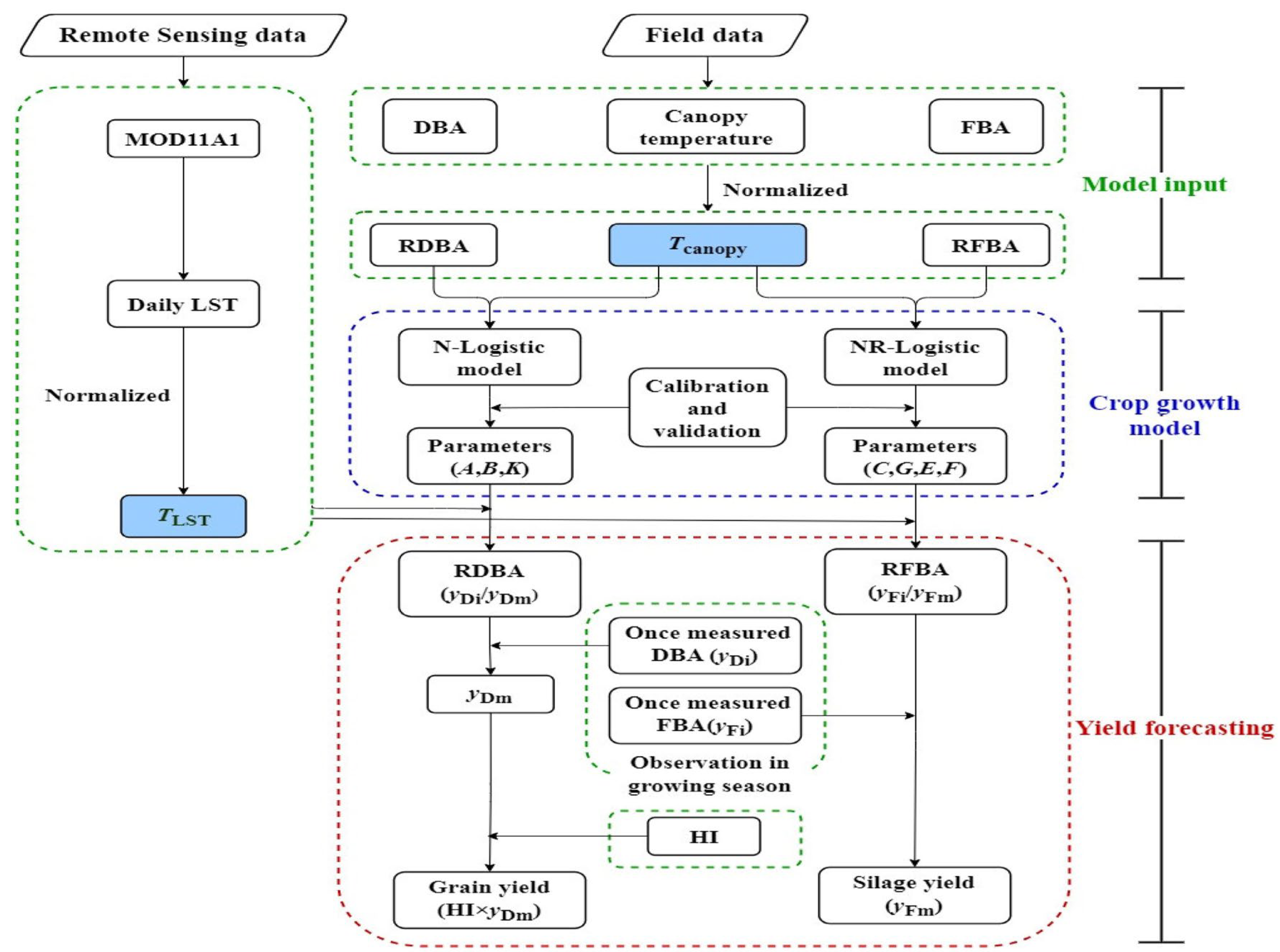
3.1. Forcing Method
3.2. Model Parameter Optimization DA
- represents the mode prediction operator from 0 to i, and has , and the forward prediction mode can be expressed as the product of the intermediate prediction mode, that is, .
- Under the tangent linearity hypothesis, the pattern operator and the observation operator are linearized, that is, , where and are the tangent operators of the pattern operator and the observation operator, respectively, and the minimum value of J is solved by gradient descent or conjugate gradient method. The obtained is the optimal solution of the initial state.
- Explore the advantages of optimization algorithms such as conjugate gradient method and quasi-Newton method in solving gradient problems. Global optimization techniques such as multiple startup, simulated annealing, and genetic algorithm were used to improve the initialization and optimization strategy of the algorithm and improve the convergence and stability of the algorithm [113]. Try to calibrate the sensitivity error of the initial conditions based on the model.
- Search for nonlinear framework: To solve nonlinear uncertainty, explore and develop nonlinear variational assimilation frameworks, such as manifold embedding variational method (ME-Var), four-dimensional variational filtering (4D-VARF), etc. For example, the anisotropic background error and time-window four-dimensional variation algorithm constructed by Wu et al. provides us with valuable reference experience [141].
- Focusing on uncertainty characterization and quantification. Introducing set members to model uncertainty: set Kalman filtering idea, and developing assimilation methods such as set four-dimensional variational (En-4D-Var) [142]. In terms of physical and chemical parameters, we need to pay attention to the quantification of the uncertainty, reduce the uncertainty through the integration of assimilation methods, and improve the adaptability and scalability of assimilation algorithms.
3.3. Model Status Update DA
- Forecast
- Update
3.4. Bayesian Normal Form DA
4. Discussion
4.1. Challenges Faced by DA in Agricultural Application
4.1.1. Deep Fusion and Uncertainty Management of Multi-Source Heterogeneous Data
4.1.2. Refinement and Dynamic Updating of Complex Crop Growth Models
4.1.3. From Univariate Assimilation to Multivariable and Multiscale Assimilation
4.2. The Future Development Prospect of DA
4.2.1. Intelligent and Integrated DA
4.2.2. DA Applicability of Decision Support for Precision Agriculture
5. Conclusions
Author Contributions
Funding
Data Availability Statement
Conflicts of Interest
Nomenclature
References
- Li, Z.; Fan, C.; Zhao, Y.; Jin, X.; Casa, R.; Huang, W.; Song, X.; Blasch, G.; Yang, G.; Taylor, J.; et al. Remote sensing of quality traits in cereal and arable production systems: A review. Crop J. 2024, 12, 45–57. [Google Scholar] [CrossRef]
- Lokosang, L.; Ramroop, S.; Hendriks, S.L. Establishing a Robust Technique for Monitoring and Early Warning of Food Insecurity in Post-Conflict South Sudan Using Ordinal Logistic Regression. Agrekon 2011, 50, 101–130. [Google Scholar] [CrossRef]
- Vannoppen, A.; Gobin, A.; Kotova, L.; Top, S.; De Cruz, L.; Vīksna, A.; Aniskevich, S.; Bobylev, L.; Buntemeyer, L.; Caluwaerts, S.; et al. Wheat Yield Estimation from NDVI and Regional Climate Models in Latvia. Remote Sens. 2020, 12, 2206. [Google Scholar] [CrossRef]
- Wang, S.; Huang, K.; Yan, H.; Yan, H.; Zhou, L.; Wang, H.; Zhang, J.; Yan, J.; Zhao, L.; Wang, Y.; et al. Improving the light use efficiency model for simulating terrestrial vegetation gross primary production by the inclusion of diffuse radiation across ecosystems in China. Ecol. Complex. 2015, 23, 1–13. [Google Scholar] [CrossRef]
- He, L.; Zhongxin, C.; Gaohuan, L.; Zhiwei, J.; Chong, H. Improving Winter Wheat Yield Estimation from the CERES-Wheat Model to Assimilate Leaf Area Index with Different Assimilation Methods and Spatio-Temporal Scales. Remote Sens. 2017, 9, 190. [Google Scholar] [CrossRef]
- Liu, F.; Li, C.; Dong, Y.; Wang, Q.; Wang, J.; Huang, W. Monitoring crop growth based on assimilation of remote sensing data and crop simulation model. Editor. Off. Trans. Chin. Soc. Agric. Eng. 2011, 27, 101–106. [Google Scholar]
- Qu, C.; Wang, Z.; Jin, X.; Wang, X.; Wang, D. A moisture content prediction model for deep bed peanut drying using support vector regression. J. Food Process Eng. 2020, 43, e13510. [Google Scholar] [CrossRef]
- Gu, Q.; Han, Y.; Xu, Y.; Yao, H.; Niu, H.; Huang, F. Laboratory Research on Polarized Optical Properties of Saline-Alkaline Soil Based on Semi-Empirical Models and Machine Learning Methods. Remote Sens. 2022, 14, 226. [Google Scholar] [CrossRef]
- Mito, C.O.; Boiyo, R.K.; Laneve, G. A simple algorithm to estimate sensible heat flux from remotely sensed MODIS data. Int. J. Remote Sens. 2012, 33, 6109–6121. [Google Scholar] [CrossRef]
- Mottaleb, K.A.; Gumma, M.K.; Mishra, A.K.; Mohanty, S. Quantifying Production Losses due to Drought and Submergence of Rainfed Rice at the Household Level Using Remotely Sensed MODIS Data. Agric. Syst. 2014, 137, 227–235. [Google Scholar] [CrossRef]
- Tan, C.-W.; Zhang, P.-P.; Zhou, X.-X.; Wang, Z.-X.; Xu, Z.-Q.; Mao, W.; Li, W.-X.; Huo, Z.-Y.; Guo, W.-S.; Yun, F. Quantitative monitoring of leaf area index in wheat of different plant types by integrating NDVI and Beer-Lambert law. Sci. Rep. 2020, 10, 929. [Google Scholar] [CrossRef] [PubMed]
- Sun, K.; Su, Q.; Ming, Y. Dust Storm Remote Sensing Monitoring Supported by MODIS Land Surface Reflectance Database. Remote Sens. 2019, 11, 1772. [Google Scholar] [CrossRef]
- Parisay, Z.; Sheikh, V.; Bahremand, A.; Komaki, C.B.; Abdollahi, K. An Approach for Estimating Monthly Curve Number Based on Remotely-Sensed MODIS Leaf Area Index Products. Water Resour. Manag. 2019, 33, 2955–2972. [Google Scholar] [CrossRef]
- Wang, J.B.; Zhao, X.L.; Ye, H.; Zhang, Z.J.; He, H.L. Integration of evapotranspiration remote sensing products based on Bayesian model averaging: An example from Three-River-Source National Park. J. Appl. Ecol. 2021, 32, 2119–2128. [Google Scholar]
- Costa, D.d.A.; Bayissa, Y.; Junior, J.L.; Yamasaki, E.N.; Kyriakides, I.; Neto, A.J.S. Cyprus Surface Water Area Variation Based on the 1984–2021 Time Series Built from Remote Sensing Products. Remote Sens. 2023, 15, 5288. [Google Scholar] [CrossRef]
- Wichitwechkarn, V.; Rohde, W.; Fox, C.; Choudhary, R. Data-driven definition and modelling of plant growth. Smart Agric. Technol. 2024, 8, 100495. [Google Scholar] [CrossRef]
- Liu, Y.; Wang, B.; Sheng, Q.; Li, J.; Zhao, H.; Wang, S.; Liu, X.; He, H. Dual-polarization SAR rice growth model: A modeling approach for monitoring plant height by combining crop growth patterns with spatiotemporal SAR data. Comput. Electron. Agric. 2023, 215, 108358. [Google Scholar] [CrossRef]
- Senko, H.; Kajić, S.; Huđ, A.; Palijan, G.; Petek, M.; Rajnović, I.; Šamec, D.; Udiković-Kolić, N.; Mešić, A.; Brkljačić, L.; et al. Will the beneficial properties of plant-growth promoting bacteria be affected by waterlogging predicted in the wake of climate change: A model study. Appl. Soil Ecol. 2024, 198, 105379. [Google Scholar] [CrossRef]
- Kinose, Y.; Fukamachi, Y.; Okabe, S.; Hiroshima, H.; Watanabe, M.; Izuta, T. Toward an impact assessment of ozone on plant carbon fixation using a process-based plant growth model: A case study of Fagus crenata grown under different soil nutrient levels. Sci. Total Environ. 2020, 716, 137008. [Google Scholar] [CrossRef]
- Prates-Clark, C.D.; Saatchi, S.S.; Agosti, D. Predicting geographical distribution models of high-value timber trees in the Amazon Basin using remotely sensed data. Ecol. Model. 2008, 211, 309–323. [Google Scholar] [CrossRef]
- Buermann, W.; Saatchi, S.; Smith, T.B.; Zutta, B.R.; Chaves, J.A.; Milá, B.; Graham, C.H. Predicting species distributions across the Amazonian and Andean regions using remote sensing data. J. Biogeogr. 2008, 35, 1160–1176. [Google Scholar] [CrossRef]
- Al-Bakri, J.; Suleiman, A.; Berg, A. A comparison of two models to predict soil moisture from remote sensing data of RADARSAT II. Arab. J. Geosci. 2014, 7, 4851–4860. [Google Scholar] [CrossRef]
- Barnes, B.B.; Hallock, P.; Hu, C.; Muller-Karger, F.; Palandro, D.; Walter, C.; Zepp, R. Prediction of coral bleaching in the Florida Keys using remotely sensed data. Coral Reefs 2015, 34, 491–503. [Google Scholar] [CrossRef]
- Wang, J.; Wang, Z.; Lu, B. Assimilation of HJ-LAI into the WOFOST model for estimating regional rice yield. In MIPPR 2019: Remote Sensing Image Processing, Geographic Information Systems, and Other Applications; SPIE: Paris, France, 2020; Volume 11432. [Google Scholar]
- Ma, Y.; Wang, S. A review on research of implement application for crop simulation model in regional scale by using remote sensing technology. Chin. J. Appl. Ecol. 2004, 15, 1655–1661. [Google Scholar]
- Bai, T.; Wang, S.; Meng, W.; Zhang, N.; Wang, T.; Chen, Y.; Mercatoris, B. Assimilation of Remotely-Sensed LAI into WOFOST Model with the SUBPLEX Algorithm for Improving the Field-Scale Jujube Yield Forecasts. Remote Sens. 2019, 11, 1945. [Google Scholar] [CrossRef]
- Mallick, J.; Ahmed, M.; Alqadhi, S.D.; Falqi, I.I.; Parayangat, M.; Singh, C.K.; Rahman, A.; Ijyas, T. Spatial stochastic model for predicting soil organic matter using remote sensing data. Geocarto Int. 2022, 37, 413–444. [Google Scholar] [CrossRef]
- Zhang, L.; Guo, C.; Zhao, L.; Zhu, Y.; Cao, W.; Tian, Y.; Cheng, T.; Wang, X. Estimating wheat yield by integrating the WheatGrow and PROSAIL models. Field Crops Res. 2016, 192, 55–66. [Google Scholar] [CrossRef]
- Kasampalis, D.A.; Alexandridis, T.K.; Deva, C.; Challinor, A.; Moshou, D.; Zalidis, G. Contribution of Remote Sensing on Crop Models: A Review. J. Imaging 2018, 4, 52. [Google Scholar] [CrossRef]
- Jin, X.; Kumar, L.; Li, Z.; Feng, H.; Xu, X.; Yang, G.; Wang, J. A review of data assimilation of remote sensing and crop models. Eur. J. Agron. 2018, 92, 141–152. [Google Scholar] [CrossRef]
- Chisanga, C.B.; Phiri, E.; Chinene, V.R.N.; Chabala, L.M. Projecting maize yield under local-scale climate change sce-narios using crop models: Sensitivity to sowing dates, cultivar, and nitrogen fertilizer rates. Food Energy Secur. 2020, 9, e231. [Google Scholar] [CrossRef]
- Martínez, M.M.; Nakaegawa, T.; Pinzón, R.; Kusunoki, S.; Gordón, R.; Sanchez-Galan, J.E. Using a Statistical Crop Model to Predict Maize Yield by the End-Of-Century for the Azuero Region in Panama. Atmosphere 2020, 11, 1097. [Google Scholar] [CrossRef]
- McCown, R.; Hammer, G.; Hargreaves, J.; Holzworth, D.; Freebairn, D. APSIM: A novel software system for model development, model testing and simulation in agricultural systems research. Agric. Syst. 1996, 50, 255–271. [Google Scholar] [CrossRef]
- Rasmussen, J.; Ntakos, G.; Nielsen, J.; Svensgaard, J.; Poulsen, R.N.; Christensen, S. Are vegetation indices derived from consumer-grade cameras mounted on UAVs sufficiently reliable for assessing experimental plots? Eur. J. Agron. 2016, 74, 75–92. [Google Scholar] [CrossRef]
- Hsiao, T.C.; Heng, L.; Steduto, P.; Rojas-Lara, B.; Raes, D.; Fereres, E. AquaCrop—The FAO Crop Model to Simulate Yield Response to Water: III. Parameterization and Testing for Maize. Agron. J. 2009, 101, 448. [Google Scholar] [CrossRef]
- Jing, Q.; van Keulen, H.; Hengsdijk, H. Modeling biomass, nitrogen and water dynamics in rice–wheat rotations. Agric. Syst. 2010, 103, 433–443. [Google Scholar] [CrossRef]
- Batchelor, W.D.; Basso, B.; Paz, J.O. Examples of strategies to analyze spatial and temporal yield variability using crop models. Eur. J. Agron. 2002, 18, 141–158. [Google Scholar] [CrossRef]
- Stöckle, C.O.; Donatelli, M.; Nelson, R. CropSyst, a cropping systems simulation model. Eur. J. Agron. 2003, 18, 289–307. [Google Scholar] [CrossRef]
- Palosuo, T.; Kersebaum, K.C.; Angulo, C.; Hlavinka, P.; Moriondo, M.; Olesen, J.E.; Patil, R.H.; Ruget, F.; Rumbaur, C.; Takáč, J.; et al. Simulation of winter wheat yield and its variability in different climates of Europe: A comparison of eight crop growth models. Eur. J. Agron. 2011, 35, 103–114. [Google Scholar] [CrossRef]
- Jones, J.W.; Hoogenboom, G.; Porter, C.H.; Boote, K.J.; Batchelor, W.D.; Hunt, L.A.; Wilkens, P.W.; Singh, U.; Gijsman, A.J.; Ritchie, J.T. The DSSAT cropping system model. Eur. J. Agron. 2003, 18, 235–265. [Google Scholar] [CrossRef]
- Challinor, A.J.; Wheeler, T.R.; Craufurd, P.Q.; Slingo, J.M.; Grimes, D.I. Design and optimisation of a large-area pro-cess-based model for annual crops. Agric. For. Meteorol. 2004, 124, 99–120. [Google Scholar] [CrossRef]
- Brisson, N.; Mary, B.; Ripoche, D.; Jeuffroy, M.H.; Ruget, F.; Nicoullaud, B.; Gate, P.; Devienne-Barret, F.; Antonioletti, R.; Durr, C.; et al. STICS: A generic model for the simulation of crops and their water and nitrogen balances. I. Theory and parameterization applied to wheat and corn. Agronomie 1998, 18, 311–346. [Google Scholar] [CrossRef]
- Bouman, B.A.M. Linking physical remote sensing models with crop growth simulation models, applied for sugar beet. Int. J. Remote Sens. 1992, 13, 2565–2581. [Google Scholar] [CrossRef]
- Huang, J.; Ma, H.; Su, W.; Zhang, X.; Huang, Y.; Fan, J.; Wu, W. Jointly Assimilating MODIS LAI and ET Products Into the SWAP Model for Winter Wheat Yield Estimation. IEEE J. Sel. Top. Appl. Earth Obs. Remote Sens. 2015, 8, 4060–4071. [Google Scholar] [CrossRef]
- Bansouleh, B.F.; Sargordi, F.; Sharifi, M.A.; Van, H. Point-based simulation of barley production using the crop growth simulation model WOFOST. In Proceedings of the First International Conference on Plant, Water, Soil & Weather Modeling, Kerman, Iran, 14–15 November 2010. [Google Scholar]
- Lv, Z.; Liu, X.; Tang, L.; Liu, L.; Cao, W.; Zhu, Y. Estimation of ecotype-specific cultivar parameters in a wheat phenology model and uncertainty analysis. Agric. For. Meteorol. 2016, 221, 219–229. [Google Scholar] [CrossRef]
- Jin, N.; Tao, B.; Ren, W.; He, L.; Zhang, D.; Wang, D.; Yu, Q. Assimilating remote sensing data into a crop model improves winter wheat yield estimation based on regional irrigation data. Agric. Water Manag. 2022, 266, 107583. [Google Scholar] [CrossRef]
- Huang, G.D. Assimilation of remote sensing into crop growth models: Current status and perspectives. Agric. For. Meteorol. 2019, 276, 107609. [Google Scholar] [CrossRef]
- White, J.W.; Hunt, L.; Boote, K.J.; Jones, J.W.; Koo, J.; Kim, S.; Porter, C.H.; Wilkens, P.W.; Hoogenboom, G. Integrated description of agricultural field experiments and production: The ICASA Version 2.0 data standards. Comput. Electron. Agric. 2013, 96, 1–12. [Google Scholar] [CrossRef]
- Tian, J.; Qin, J.; Yang, K.; Zhao, L.; Chen, Y.; Lu, H.; Li, X.; Shi, J. Improving surface soil moisture retrievals through a novel assimilation algorithm to estimate both model and observation errors. Remote Sens. Environ. 2022, 269, 112802. [Google Scholar] [CrossRef]
- Lewis, P.; Gómez-Dans, J.; Kaminski, T.; Settle, J.; Quaife, T.; Gobron, N.; Styles, J.; Berger, M. An Earth Observation Land Data Assimilation System (EO-LDAS). Remote Sens. Environ. 2012, 120, 219–235. [Google Scholar] [CrossRef]
- Luo, L.; Sun, S.; Xue, J.; Gao, Z.; Zhao, J.; Yin, Y.; Gao, F.; Luan, X. Crop yield estimation based on assimilation of crop models and remote sensing data: A systematic evaluation. Agric. Syst. 2023, 210, 103711. [Google Scholar] [CrossRef]
- Tang, Y.; Zhou, R.; He, P.; Yu, M.; Zheng, H.; Yao, X.; Cheng, T.; Zhu, Y.; Cao, W.; Tian, Y. Estimating wheat grain yield by assimilating phenology and LAI with the WheatGrow model based on theoretical uncertainty of remotely sensed observation. Agric. For. Meteorol. 2023, 339, 109574. [Google Scholar] [CrossRef]
- Dente, L.; Satalino, G.; Mattia, F.; Rinaldi, M. Assimilation of leaf area index derived from ASAR and MERIS data into CERES-Wheat model to map wheat yield. Remote Sens. Environ. 2008, 112, 1395–1407. [Google Scholar] [CrossRef]
- Curnel, Y.; de Wit, A.J.W.; Duveiller, G.; Defourny, P. Potential performances of remotely sensed LAI assimilation in WOFOST model based on an OSS Experiment. Agric. For. Meteorol. 2011, 151, 1843–1855. [Google Scholar] [CrossRef]
- Zhang, H.; Qin, S.; Ma, J.; You, H. Using Residual Resampling and Sensitivity Analysis to Improve Particle Filter Data Assimilation Accuracy. IEEE Geosci. Remote Sens. Lett. 2013, 10, 1404–1408. [Google Scholar] [CrossRef]
- Kumar, A.S.; Reddy, A.M.; Srinivas, L.; Reddy, P.M. Assessment of Surface Water Quality in Hyderabad Lakes by Using Multivariate Statistical Techniques, Hyderabad-India. Environ. Pollut. 2015, 4, 14. [Google Scholar] [CrossRef]
- Odermatt, D.; Danne, O.; Philipson, P.; Brockmann, C. Diversity II water quality parameters from ENVISAT (2002–2012): A new global information source for lakes. Earth Syst. Sci. Data 2018, 10, 1527–1549. [Google Scholar] [CrossRef]
- Shang, P.; Shen, F. Atmospheric Correction of Satellite GF-1/WFV Imagery and Quantitative Estimation of Suspended Particulate Matter in the Yangtze Estuary. Sensors 2016, 16, 1997. [Google Scholar] [CrossRef]
- Huang, G. Improving the Consistency of Nonlinear Estimators: Analysis, Algorithms, and Applications. Ph.D. Thesis, University of Minnesota, Minneapolis, MN, USA, 2013. [Google Scholar]
- Wang, S.; Zhuang, Q.; Jin, X.; Yang, Z.; Liu, H. Predicting Soil Organic Carbon and Soil Nitrogen Stocks in Topsoil of Forest Ecosystems in Northeastern China Using Remote Sensing Data. Remote Sens. 2020, 12, 1115. [Google Scholar] [CrossRef]
- Li, H.; Chen, Z.; Wu, W.; Jiang, Z.; Liu, B.; Hasi, T. Crop model data assimilation with particle filter for yield prediction using leaf area index of different temporal scales. In Proceedings of the 2015 Fourth International Conference on Agro-Geoinformatics, Istanbul, Turkey, 20–24 July 2015. [Google Scholar]
- Araújo, S.R.; Demattê, J.A.M.; Bellinaso, H. Analysing the effects of applying agricultural lime to soils by VNIR spectral sensing: A quantitative and quick method. Int. J. Remote Sens. 2013, 34, 4570–4584. [Google Scholar] [CrossRef]
- Angelopoulou, T.; Dimitrakos, A.; Terzopoulou, E.; Zalidis, G.; Theocharis, J.; Stafilov, T.; Zouboulis, A. Reflectance Spectroscopy (Vis-NIR) for Assessing Soil Heavy Metals Concentrations Determined by two Different Analytical Protocols, Based on ISO 11466 and ISO 14869-1. Water Air Soil Pollut. 2017, 228, 436. [Google Scholar] [CrossRef]
- Dibi, W.G.; Bosson, J.; Zobi, I.C.; Tié, B.T.; Zoueu, J.T. Use of Fluorescence and Reflectance Spectra for Predicting Okra (Abelmoschus esculentus) Yield and Macronutrient Contents of Leaves. Open J. Appl. Sci. 2017, 7, 537–558. [Google Scholar]
- Skakun, S.; Kalecinski, N.I.; Brown, M.G.L.; Johnson, D.M.; Vermote, E.F.; Roger, J.-C.; Franch, B. Assessing within-Field Corn and Soybean Yield Variability from WorldView-3, Planet, Sentinel-2, and Landsat 8 Satellite Imagery. Remote Sens. 2021, 13, 872. [Google Scholar] [CrossRef]
- Antonarakis, A.S.; Saatchi, S.S.; Chazdon, R.L.; Moorcroft, P.R. Using Lidar and Radar measurements to constrain pre-dictions of forest ecosystem structure and function. Ecol. Appl. A Publ. Ecol. Soc. Am. 2011, 21, 1120–1137. [Google Scholar]
- Peters, S.; Liu, J.; Bruce, D.; Finn, A.; O’hehir, J. Research note: Cost-efficient estimates of Pinus radiata wood volumes using multitemporal LiDAR data. Aust. For. 2021, 84, 206–214. [Google Scholar] [CrossRef]
- Chen, Y.; Tao, F. Improving the practicability of remote sensing data-assimilation-based crop yield estimations over a large area using a spatial assimilation algorithm and ensemble assimilation strategies. Agric. For. Meteorol. 2020, 291, 108082. [Google Scholar] [CrossRef]
- Kadhim, N.; Mourshed, M.; Bray, M. Advances in remote sensing applications for urban sustainability. Euro-Mediterranean J. Environ. Integr. 2016, 1, 7. [Google Scholar] [CrossRef]
- Wijmer, T.; Al Bitar, A.; Arnaud, L.; Fieuzal, R.; Ceschia, E. AgriCarbon-EO v1.0.1: Large-scale and high-resolution simulation of carbon fluxes by assimilation of Sentinel-2 and Landsat-8 reflectances using a Bayesian approach. Geosci. Model Dev. 2024, 17, 997–1021. [Google Scholar] [CrossRef]
- Allies, A.; Roumiguié, A.; Dejoux, J.-F.; Fieuzal, R.; Jacquin, A.; Veloso, A.; Champolivier, L.; Baup, F. Evaluation of Multiorbital SAR and Multisensor Optical Data for Empirical Estimation of Rapeseed Biophysical Parameters. IEEE J. Sel. Top. Appl. Earth Obs. Remote Sens. 2021, 14, 7268–7283. [Google Scholar] [CrossRef]
- Dlamini, L.; Crespo, O.; van Dam, J.; Kooistra, L. A Global Systematic Review of Improving Crop Model Estimations by Assimilating Remote Sensing Data: Implications for Small-Scale Agricultural Systems. Remote Sens. 2023, 15, 4066. [Google Scholar] [CrossRef]
- Bouras, E.H.; Olsson, P.-O.; Thapa, S.; Díaz, J.M.; Albertsson, J.; Eklundh, L. Wheat Yield Estimation at High Spatial Resolution through the Assimilation of Sentinel-2 Data into a Crop Growth Model. Remote Sens. 2023, 15, 4425. [Google Scholar] [CrossRef]
- Manivasagam, V.; Sadeh, Y.; Kaplan, G.; Bonfil, D.J.; Rozenstein, O. Studying the Feasibility of Assimilating Sentinel-2 and PlanetScope Imagery into the SAFY Crop Model to Predict Within-Field Wheat Yield. Remote Sens. 2021, 13, 2395. [Google Scholar] [CrossRef]
- Gilardelli, C.; Stella, T.; Confalonieri, R.; Ranghetti, L.; Campos-Taberner, M.; García-Haro, F.J.; Boschetti, M. Downscaling rice yield simulation at sub-field scale using remotely sensed LAI data. Eur. J. Agron. 2019, 103, 108–116. [Google Scholar] [CrossRef]
- Ogweno, V.W.; Moore, N.; Wanyama, D. Assessing cropland disagreement in Tanzania using machine learning methods with Sentinel-2 and Planet Scope imagery. Int. J. Remote. Sens. 2023, 44, 6716–6735. [Google Scholar] [CrossRef]
- Wulder, M.A.; Roy, D.P.; Radeloff, V.C.; Loveland, T.R.; Anderson, M.C.; Johnson, D.M.; Healey, S.; Zhu, Z.; Scambos, T.A.; Pahlevan, N.; et al. Fifty years of Landsat science and impacts. Remote Sens. Environ. 2022, 280. [Google Scholar] [CrossRef]
- Huang, Y.; Brand, H.J.; Sui, R.; Thomson, S.J.; Furukawa, T.; Ebelhar, M.W. Cotton Yield Estimation Using Very High-Resolution Digital Images Acquired with a Low-Cost Small Unmanned Aerial Vehicle. Trans. ASABE 2016, 59, 1563–1574. [Google Scholar] [CrossRef]
- Liao, Z.-Q.; Dai, Y.-L.; Wang, H.; Ketterings, Q.M.; Lu, J.-S.; Zhang, F.-C.; Li, Z.-J.; Fan, J.-L. A double-layer model for improving the estimation of wheat canopy nitrogen content from unmanned aerial vehicle multispectral imagery. J. Integr. Agric. 2023, 22, 2248–2270. [Google Scholar] [CrossRef]
- Yamagishi, Y.; Kato, Y.; Ninomiya, S.; Guo, W. Image-Based Phenotyping for Non-Destructive In Situ Rice (Oryza sativa L.) Tiller Counting Using Proximal Sensing. Sensors 2022, 22, 5547. [Google Scholar] [CrossRef] [PubMed]
- Guo, S.J.; Wu, W.F.; Shao, Z.F.; Teng, J.H.; Li, D.R. Extracting urban impervious surface based on optical and SAR images cross-modal multi-scale features fusion network. Int. J. Digit. Earth 2024, 17, 19. [Google Scholar] [CrossRef]
- Xie, Y.; Wang, P.; Liu, J.; Li, L. Winter wheat yield estimation based on assimilation method combined with 4DVAR and EnKF. Trans. Chin. Soc. Agric. Eng. 2015, 31, 187–195. [Google Scholar] [CrossRef]
- Vigneault, P.; Lafond-Lapalme, J.; Deshaies, A.; Khun, K.; de la Sablonnière, S.; Filion, M.; Longchamps, L.; Mimee, B. An integrated data-driven approach to monitor and estimate plant-scale growth using UAV. ISPRS Open J. Photogramm. Remote Sens. 2024, 11, 100052. [Google Scholar] [CrossRef]
- Zhang, B.Y.; Gu, L.M.; Dai, M.L.; Bao, X.Y.; Sun, Q.; Zhang, M.Z.; Qu, X.Z.; Li, Z.H.; Zhen, W.C.; Gu, X.H. Estimation of grain filling rate of winter wheat using leaf chlorophyll and LAI extracted from UAV images. Field Crop Res. 2024, 306, 109198. [Google Scholar] [CrossRef]
- Wang, L.L.; Huang, X.R.; Li, W.J.; Yan, K.T.; Han, Y.F.; Zhang, Y.L.; Pawlowski, L.; Lan, Y.B. Progress in Agricultural Unmanned Aerial Vehicles (UAVs) Applied in China and Prospects for Poland. Agriculture 2022, 12, 397. [Google Scholar] [CrossRef]
- Khan, A.; Malebary, S.J.; Dang, L.M.; Binzagr, F.; Song, H.-K.; Moon, H. AI-Enabled Crop Management Framework for Pest Detection Using Visual Sensor Data. Plants 2024, 13, 653. [Google Scholar] [CrossRef]
- Zhang, J.; Pan, B.; Shi, W.; Zhang, Y. Monitoring Waterlogging Damage of Winter Wheat Based on HYDRUS-1D and WOFOST Coupled Model and Assimilated Soil Moisture Data of Remote Sensing. Remote Sens. 2023, 15, 4133. [Google Scholar] [CrossRef]
- Jannoura, R.; Brinkmann, K.; Uteau, D.; Bruns, C.; Joergensen, R.G. Monitoring of crop biomass using true colour aerial photographs taken from a remote controlled hexacopter. Biosyst. Eng. 2015, 129, 341–351. [Google Scholar] [CrossRef]
- Adão, T.; Hruška, J.; Pádua, L.; Bessa, J.; Peres, E.; Morais, R.; Sousa, J.J. Hyperspectral Imaging: A Review on UAV-Based Sensors, Data Processing and Applications for Agriculture and Forestry. Remote Sens. 2017, 9, 1110. [Google Scholar] [CrossRef]
- Milella, A.; Reina, G.; Nielsen, M. A multi-sensor robotic platform for ground mapping and estimation beyond the visible spectrum. Precis. Agric. 2019, 20, 423–444. [Google Scholar] [CrossRef]
- Kurtser, P.; Ringdahl, O.; Rotstein, N.; Berenstein, R.; Edan, Y. In-Field Grape Cluster Size Assessment for Vine Yield Estimation Using a Mobile Robot and a Consumer Level RGB-D Camera. IEEE Robot. Autom. Lett. 2020, 5, 2031–2038. [Google Scholar] [CrossRef]
- Schultz, J.A.; Hartmann, M.; Heinemann, S.; Janke, J.; Jürgens, C.; Oertel, D.; Rücker, G.; Thonfeld, F.; Rienow, A. DIEGO: A Multispectral Thermal Mission for Earth Observation on the International Space Station. Eur. J. Remote Sens. 2020, 53, 28–38. [Google Scholar] [CrossRef]
- Zhang, K.; Zhao, L.; Cui, J.; Mao, P.; Yuan, B.; Liu, Y. Design and Implementation of Evaluation Method for Spraying Coverage Region of Plant Protection UAV. Agronomy 2023, 13, 1631. [Google Scholar] [CrossRef]
- Akumaga, U.; Gao, F.; Anderson, M.; Dulaney, W.P.; Houborg, R.; Russ, A.; Hively, W.D. Integration of Remote Sensing and Field Observations in Evaluating DSSAT Model for Estimating Maize and Soybean Growth and Yield in Maryland, USA. Agronomy 2023, 13, 1540. [Google Scholar] [CrossRef]
- Boas, T.; Bogena, H.R.; Ryu, D.; Vereecken, H.; Western, A.; Franssen, H.-J.H. Seasonal soil moisture and crop yield prediction with fifth-generation seasonal forecasting system (SEAS5) long-range meteorological forecasts in a land surface modelling approach. Hydrol. Earth Syst. Sci. 2023, 27, 3143–3167. [Google Scholar] [CrossRef]
- Sisheber, B.; Marshall, M.; Mengistu, D.; Nelson, A. Assimilation of Earth Observation Data for Crop Yield Estimation in Smallholder Agricultural Systems. IEEE J. Sel. Top. Appl. Earth Obs. Remote Sens. 2024, 17, 557–572. [Google Scholar] [CrossRef]
- Huang, S.; Zhang, X.; Chen, N.; Ma, H.; Fu, P.; Dong, J.; Gu, X.; Nam, W.; Xu, L.; Rab, G.; et al. A Novel Fusion Method for Generating Surface Soil Moisture Data With High Accuracy, High Spatial Resolution, and High Spatio-Temporal Continuity. Water Resour. Res. 2022, 58, e2021WR030827. [Google Scholar] [CrossRef]
- Rostami, A.; Raeini-Sarjaz, M.; Chabokpour, J.; Azamathulla, H.M.; Kumar, S. Determination of rainfed wheat agri-culture potential through assimilation of remote sensing data with SWAT model case study: ZarrinehRoud Basin, Iran. Water Sci. Technol. Water Supply 2022, 22, 5331–5354. [Google Scholar] [CrossRef]
- Nadeem, A.A.; Zha, Y.; Shi, L.; Ali, S.; Wang, X.; Zafar, Z.; Afzal, Z.; Tariq, M.A.U.R. Spatial Downscaling and Gap-Filling of SMAP Soil Moisture to High Resolution Using MODIS Surface Variables and Machine Learning Approaches over ShanDian River Basin, China. Remote Sens. 2023, 15, 812. [Google Scholar] [CrossRef]
- Ma, H.; Sun, S.; Wang, Z.; Jiang, Y.; Liu, S. Downscaling CLDAS Soil Moisture Product by Integrating Sentinel-1 and Sentinel-2 Data over Agricultural Area. Can. J. Remote Sens. 2022, 48, 737–746. [Google Scholar] [CrossRef]
- Tomer, S.K.; Al Bitar, A.; Sekhar, M.; Zribi, M.; Bandyopadhyay, S.; Kerr, Y. MAPSM: A Spatio-Temporal Algorithm for Merging Soil Moisture from Active and Passive Microwave Remote Sensing. Remote Sens. 2016, 8, 990. [Google Scholar] [CrossRef]
- Chen, Q.; Jia, L.; Menenti, M.; Hu, G.; Wang, K.; Yi, Z.; Zhou, J.; Peng, F.; Ma, S.; You, Q.; et al. A data-driven high spatial resolution model of biomass accumulation and crop yield: Application to a fragmented desert-oasis agroecosystem. Ecol. Model. 2023, 475, 110182. [Google Scholar] [CrossRef]
- Yang, Z.; He, Q.; Miao, S.; Wei, F.; Yu, M. Surface Soil Moisture Retrieval of China Using Multi-Source Data and Ensemble Learning. Remote Sens. 2023, 15, 2786. [Google Scholar] [CrossRef]
- Ye, F.; Zhou, Z.; Wu, Y.; Enkhtur, B. Application of convolutional neural network in fusion and classification of multi-source remote sensing data. Front. Neurorobot. 2022, 16, 1095717. [Google Scholar] [CrossRef] [PubMed]
- Qi, C.; Liu, W. Tomato Production Prediction Based on Deep Learning Algorithm-Cascade-PSPNET and Bayes. Int. J. Pattern Recognit. Artif. Intell. 2023, 37, 23. [Google Scholar] [CrossRef]
- Li, Y.; Gao, W.; Jia, J.; Tao, S.; Ren, Y. Developing and evaluating the feasibility of a new spatiotemporal fusion framework to improve remote sensing reflectance and dynamic LAI monitoring. Comput. Electron. Agric. 2022, 198, 107037. [Google Scholar] [CrossRef]
- Zhuo, W.; Huang, J.; Li, L.; Zhang, X.; Ma, H.; Gao, X.; Huang, H.; Xu, B.; Xiao, X. Assimilating Soil Moisture Retrieved from Sentinel-1 and Sentinel-2 Data into WOFOST Model to Improve Winter Wheat Yield Estimation. Remote Sens. 2019, 11, 1618. [Google Scholar] [CrossRef]
- Mathieu, P.-P.; Oneill, A. Data assimilation: From photon counts to Earth System forecasts. Remote Sens. Environ. 2008, 112, 1258–1267. [Google Scholar] [CrossRef]
- de Wit, A.; Duveiller, G.; Defourny, P. Estimating regional winter wheat yield with WOFOST through the assimilation of green area index retrieved from MODIS observations. Agric. For. Meteorol. 2012, 164, 39–52. [Google Scholar] [CrossRef]
- Zhuo, W.; Huang, H.; Gao, X.; Li, X.; Huang, J. An Improved Approach of Winter Wheat Yield Estimation by Jointly Assimilating Remotely Sensed Leaf Area Index and Soil Moisture into the WOFOST Model. Remote Sens. 2023, 15, 1825. [Google Scholar] [CrossRef]
- Wu, Y.; Xu, W.; Huang, H.; Huang, J. Bayesian Posterior-Based Winter Wheat Yield Estimation at the Field Scale through Assimilation of Sentinel-2 Data into WOFOST Model. Remote Sens. 2022, 14, 3727. [Google Scholar] [CrossRef]
- Huang, J.; Tian, L.; Liang, S.; Ma, H.; Becker-Reshef, I.; Huang, Y.; Su, W.; Zhang, X.; Zhu, D.; Wu, W. Improving winter wheat yield estimation by assimilation of the leaf area index from Landsat TM and MODIS data into the WOFOST model. Agric. For. Meteorol. 2015, 204, 106–121. [Google Scholar] [CrossRef]
- Yang, B.; Zhu, W.; Rezaei, E.E.; Li, J.; Sun, Z.; Zhang, J. The Optimal Phenological Phase of Maize for Yield Prediction with High-Frequency UAV Remote Sensing. Remote Sens. 2022, 14, 1559. [Google Scholar] [CrossRef]
- Carbone, G.J.; Narumalani, S.; King, M. Application of remote sensing and GIS technologies with physiological crop models. Photogramm. Eng. Remote Sens. 1996, 62, 171–179. [Google Scholar]
- Dorigo, W.A.; Zurita-Milla, R.; De Wit, A.J.W.; Brazile, J.; Singh, R.; Schaepman, M.E. A review on reflective remote sensing and data assimilation techniques for enhanced agroecosystem modeling. Int. J. Appl. Earth Observ. Geoinform. 2007, 9, 165–193. [Google Scholar] [CrossRef]
- Maas, S.J. Use of remotely-sensed information in agricultural crop growth models. Ecol. Model. 1988, 41, 247–268. [Google Scholar] [CrossRef]
- Delécolle, R.; Maas, S.; Guérif, M.; Baret, F. Remote sensing and crop production models: Present trends. ISPRS J. Photogramm. Remote Sens. 1992, 47, 145–161. [Google Scholar] [CrossRef]
- Lee, T.-R.; Chang, Y.-S.; Choi, J.-B.; Kim, Y.-J. Numerical simulation of cylinder oscillation by using a direct forcing technique. Nucl. Eng. Des. 2010, 240, 1941–1948. [Google Scholar] [CrossRef]
- Mohamedou, C.; Kangas, A.; Hamedianfar, A.; Vauhkonen, J. Potential of Bayesian formalism for the fusion and assimilation of sequential forestry data in time and space. Can. J. For. Res. 2022, 52, 439–449. [Google Scholar] [CrossRef]
- Chang, H.; Cai, J.; Zhang, B.; Wei, Z.; Xu, D. Early Yield Forecasting of Maize by Combining Remote Sensing Images and Field Data with Logistic Models. Remote Sens. 2023, 15, 1025. [Google Scholar] [CrossRef]
- Talagrand, O.; Courtier, P. Variational Assimilation of Meteorological Observations With the Adjoint Vorticity Equation. I: Theory. Q. J. R. Meteorol. Soc. 1987, 113, 1311–1328. [Google Scholar] [CrossRef]
- Li, H.-W.; Wang, J.; Su, H.-T. Improved particle filter based on differential evolution. Electron. Lett. 2011, 47, 1078–1079. [Google Scholar] [CrossRef]
- Dhanya, M.; Chandrasekar, A. Impact of variational assimilation using multivariate background error covariances on the simulation of monsoon depressions over India. Ann. Geophys. 2016, 34, 187–201. [Google Scholar] [CrossRef]
- Le Dimet, F.X.; Talagrand, O. Variational algorithms for analysis and assimilation of meteorological observations: Theoretical aspects. Tellus A Dyn. Meteorol. Oceanogr. 2016, 45, 449–461. [Google Scholar] [CrossRef]
- Chouinard, C.; Halle, J. Use of moisture sensitive satellite radiances in the Canadian Meteorological Centre Unified 3D-var system. Proc. SPIE Int. Soc. Opt. Eng. 2003, 4895, 63–74. [Google Scholar] [CrossRef]
- Li, J.; Chen, X.; Tian, L.; Huang, J.; Feng, L. Improved capabilities of the Chinese high-resolution remote sensing satellite GF-1 for monitoring suspended particulate matter (SPM) in inland waters: Radiometric and spatial considerations. ISPRS J. Photogramm. Remote Sens. 2015, 106, 145–156. [Google Scholar] [CrossRef]
- Rao, V.; Sandu, A. A time-parallel approach to strong-constraint four-dimensional variational data assimilation. J. Comput. Phys. 2016, 313, 583–593. [Google Scholar] [CrossRef]
- Jiang, Z.; Chen, Z.; Chen, J.; Ren, J.; Li, Z.; Sun, L. The Estimation of Regional Crop Yield Using Ensemble-Based Four-Dimensional Variational Data Assimilation. Remote Sens. 2014, 6, 2664–2681. [Google Scholar] [CrossRef]
- Wagner, M.P.; Slawig, T.; Taravat, A.; Oppelt, N. Remote Sensing Data Assimilation in Dynamic Crop Models Using Particle Swarm Optimization. ISPRS Int. J. Geo-Inf. 2020, 9, 105. [Google Scholar] [CrossRef]
- Huang, X.-Y.; Xiao, Q.; Barker, D.M.; Zhang, X.; Michalakes, J.; Huang, W.; Henderson, T.; Bray, J.; Chen, Y.; Ma, Z.; et al. Four-Dimensional Variational Data Assimilation for WRF: For-mulation and Preliminary Results. Mon. Weather Rev. 2009, 137, 299–302,305,307–314. [Google Scholar] [CrossRef]
- Alavi, M.; Albaji, M.; Golabi, M.; Naseri, A.A.; Homayouni, S. Estimation of sugarcane evapotranspiration from remote sensing and limited meteorological variables using machine learning models. J. Hydrol. 2024, 629, 130605. [Google Scholar] [CrossRef]
- Gauthier, P.; Tanguay, M.; Laroche, S.; Pellerin, S.; Morneau, J. Extension of 3DVAR to 4DVAR: Implementation of 4DVAR at the Meteorological Service of Canada. Mon. Weather Rev. 2007, 135, 2339–2354. [Google Scholar] [CrossRef]
- Jin, Z.; Tian, X.; Duan, M.; Han, R. An Efficient Algorithm for Retrieving CO2 in the Atmosphere From Hyperspectral Measurements of Satellites: Application of NLS-4DVar Data Assimilation Method. Front. Earth Sci. 2021, 9, 688542. [Google Scholar] [CrossRef]
- Zhang, Y.; Walker, J.P.; Pauwels, V.R.N.; Sadeh, Y. Assimilation of Wheat and Soil States into the APSIM-Wheat Crop Model: A Case Study. Remote Sens. 2022, 14, 65. [Google Scholar] [CrossRef]
- Römer, U.; Narayanamurthi, M.; Sandu, A. Solving parameter estimation problems with discrete adjoint exponential integrators. Optim. Methods Softw. 2018, 33, 750–770. [Google Scholar] [CrossRef]
- Qin, J.; Liang, S.; Liu, R.; Zhang, H.; Hu, B. A Weak-Constraint-Based Data Assimilation Scheme for Estimating Surface Turbulent Fluxes. IEEE Geosci. Remote Sens. Lett. 2007, 4, 649–653. [Google Scholar] [CrossRef]
- Dong, Y.; Wang, J.; Li, C.; Yang, G.; Wang, Q.; Liu, F.; Zhao, J.; Wang, H.; Huang, W. Comparison and Analysis of Data Assimilation Algorithms for Predicting the Leaf Area Index of Crop Canopies. IEEE J. Sel. Top. Appl. Earth Obs. Remote Sens. 2013, 6, 188–201. [Google Scholar] [CrossRef]
- Jin, H.; Li, A.; Wang, J.; Bo, Y. Improvement of spatially and temporally continuous crop leaf area index by integration of CERES-Maize model and MODIS data. Eur. J. Agron. 2016, 78, 1–12. [Google Scholar] [CrossRef]
- Fang, H.; Liang, S.; Hoogenboom, G.; Teasdale, J.; Cavigelli, M. Corn-field estimation through assimilation of remotely sensed data into the CSM-CERES-Maize model. Int. J. Remote Sens. 2008, 29, 3011–3032. [Google Scholar] [CrossRef]
- Wu, S.; Yang, P.; Chen, Z.; Ren, J.; Li, H.; Sun, L. Estimating winter wheat yield by assimilation of remote sensing data with a four-dimensional variation algorithm considering anisotropic background error and time window. Agric. For. Meteorol. 2021, 301–302, 108345. [Google Scholar] [CrossRef]
- Minami, T.; Nakano, S.; Lesur, V.; Takahashi, F.; Matsushima, M.; Shimizu, H.; Nakashima, R.; Taniguchi, H.; Toh, H. A candidate secular variation model for IGRF-13 based on MHD dynamo simulation and 4DEnVar data assimilation. Earth Planets Space 2020, 72, 136. [Google Scholar] [CrossRef]
- Liu, W.; Mõttus, M.; Gastellu-Etchegorry, J.-P.; Fang, H.; Atherton, J. Seasonal and vertical variation in canopy structure and leaf spectral properties determine the canopy reflectance of a rice field. Agric. For. Meteorol. 2024, 355, 110132. [Google Scholar] [CrossRef]
- Huang, G.; Guo, Y.; Tan, W.; Zhang, M.; Li, Z.; Zhou, Y.; Duan, L. Enhancing maize radiation use efficiency under high planting density by shaping canopy architecture with a plant growth regulator. Crop Environ. 2024, 3, 51–63. [Google Scholar] [CrossRef]
- Shu, M.; Li, Q.; Ghafoor, A.; Zhu, J.; Li, B.; Ma, Y. Using the plant height and canopy coverage to estimation maize aboveground biomass with UAV digital images. Eur. J. Agron. 2023, 151, 126957. [Google Scholar] [CrossRef]
- Blessing, S.; Giering, R.; van der Tol, C. OptiSAIL: A system for the simultaneous retrieval of soil, leaf, and canopy parameters and its application to Sentinel-3 Synergy (OLCI + SLSTR) top-of-canopy reflectances. Sci. Remote Sens. 2024, 10, 100148. [Google Scholar] [CrossRef]
- Evensen, G. Sequential data assimilation with a nonlinear quasi-geostrophic model using Monte Carlo methods to forecast error statistics. J. Geophys. Res. Oceans 1994, 99, 10143–10162. [Google Scholar] [CrossRef]
- Burgers, G.J.H.; Leeuwen, P.J.V.; Evensen, G. Analysis Scheme in the Ensemble Kalman Filter. Mon. Weather Rev. 1998, 126, 1719–1724. [Google Scholar] [CrossRef]
- Evensen, G. The Ensemble Kalman Filter: Theoretical formulation and practical implementation. Ocean Dyn. 2003, 53, 343–367. [Google Scholar] [CrossRef]
- Gao, J.; Xue, M.; Stensrud, D.J. The Development of a Hybrid EnKF-3DVAR Algorithm for Storm-Scale Data Assimilation. Adv. Meteorol. 2013, 2013, 179–182. [Google Scholar] [CrossRef]
- Montaldo, N.; Gaspa, A.; Corona, R. Multiscale Assimilation of Sentinel and Landsat Data for Soil Moisture and Leaf Area Index Predictions Using an Ensemble-Kalman-Filter-Based Assimilation Approach in a Heterogeneous Ecosystem. Remote Sens. 2022, 14, 3458. [Google Scholar] [CrossRef]
- Ren, S.; Chen, H.; Hou, J.; Zhao, P.; Dong, Q.; Feng, H. Based on historical weather data to predict summer field-scale maize yield: Assimilation of remote sensing data to WOFOST model by ensemble Kalman filter algorithm. Comput. Electron. Agric. 2024, 219, 108822. [Google Scholar] [CrossRef]
- Pauwels, V.R.N.; Verhoest, N.E.C.; Lannoy, G.J.M.D.; Guissard, V.; Lucau, C.; Defourny, P. Optimization of a coupled hydrology-crop growth model through the assimilation of observed soil moisture and leaf area index values using an ensemble Kalman filter. Water Resour. Res. 2007, 43, 4417–4421. [Google Scholar] [CrossRef]
- Kalnay, E.; Li, H.; Miyoshi, T.; Yang, S.-C.; Ballabrera-Poy, J. 4-D-Var or ensemble Kalman filter? Tellus A 2007, 59, 758–773. [Google Scholar] [CrossRef]
- Dhakar, R.; Sehgal, V.K.; Chakraborty, D.; Sahoo, R.N.; Mukherjee, J.; Ines, A.V.; Kumar, S.N.; Shirsath, P.B.; Roy, S.B. Field scale spatial wheat yield forecasting system under limited field data availability by integrating crop simulation model with weather forecast and satellite remote sensing. Agric. Syst. 2022, 195, 103299. [Google Scholar] [CrossRef]
- Silvestro, P.C.; Casa, R.; Hanuš, J.; Koetz, B.; Rascher, U.; Schuettemeyer, D.; Siegmann, B.; Skokovic, D.; Sobrino, J.; Tudoroiu, M. Synergistic Use of Multispectral Data and Crop Growth Modelling for Spatial and Temporal Evapotranspiration Estimations. Remote Sens. 2021, 13, 2138. [Google Scholar] [CrossRef]
- Kang, Y.; Özdoğan, M. Field-level crop yield mapping with Landsat using a hierarchical data assimilation approach. Remote Sens. Environ. 2019, 228, 144–163. [Google Scholar] [CrossRef]
- Ines, A.V.; Das, N.N.; Hansen, J.W.; Njoku, E.G. Assimilation of remotely sensed soil moisture and vegetation with a crop simulation model for maize yield prediction. Remote Sens. Environ. 2013, 138, 149–164. [Google Scholar] [CrossRef]
- Dreano, D.; Tandeo, P.; Pulido, M.; Ait-El-Fquih, B.; Chonavel, T.; Hoteit, I. Estimating model-error covariances in nonlinear state-space models using Kalman smoothing and the expectation–maximization algorithm. Q. J. R. Meteorol. Soc. 2017, 143, 1877–1885. [Google Scholar] [CrossRef]
- Jun, M.; Szunyogh, I.; Genton, M.G.; Zhang, F.Q.; Bishop, C.H. A Statistical Investigation of the Sensitivity of Ensemble-Based Kalman Filters to Covariance Filtering. Mon. Weather Rev. 2011, 139, 3036–3051. [Google Scholar] [CrossRef]
- Zhao, Y.; Chen, S.; Shen, S. Assimilating remote sensing information with crop model using Ensemble Kalman Filter for improving LAI monitoring and yield estimation. Ecol. Model. 2013, 270, 30–42. [Google Scholar] [CrossRef]
- Casa, R.; Varella, H.; Buis, S.; Guerif, M.; Solan, B.D.; Baret, F. Forcing a wheat crop model with LAI data to access ag-ronomic variables: Evaluation of the impact of model and LAI uncertainties and comparison with an empirical approach. Eur. J. Agron. 2012, 37, 1–10. [Google Scholar] [CrossRef]
- Gilpin, S.; Matsuo, T.; Cohn, S.E. A generalized, compactly supported correlation function for data assimilation applications. Q. J. R. Meteorol. Soc. 2023, 149, 1953–1989. [Google Scholar] [CrossRef]
- Chakrabarti, S.; Bongiovanni, T.; Judge, J.; Zotarelli, L.; Bayer, C. Assimilation of SMOS Soil Moisture for Quantifying Drought Impacts on Crop Yield in Agricultural Regions. IEEE J. Sel. Top. Appl. Earth Obs. Remote Sens. 2017, 7, 3867–3879. [Google Scholar] [CrossRef]
- Liao, Q. Uncertainty Quantification and Data Assimilation via Transform Process for Strongly Nonlinear Problems. Ph.D. Thesis, University of Southern California, Los Angeles, CA, USA, 2014. [Google Scholar]
- Aftab, S.; Moghadam, R.H. Robust data smoothing algorithms and wavelet filter for denoising sonic log signals. J. Appl. Geophys. 2022, 206, 104836. [Google Scholar] [CrossRef]
- Yu, X.K.; Li, J.X. Optimal Filtering and a Smoothing Algorithm for a Singular System With a Complex Stochastic Uncertain Parameter Matrix. IEEE Trans. Circuits Syst. II Express Briefs 2020, 67, 780–784. [Google Scholar] [CrossRef]
- Xiao, D.; Du, J.; Fang, F.; Pain, C.C.; Li, J. Parameterised non-intrusive reduced order methods for ensemble Kalman filter data assimilation. Comput. Fluids 2018, 177, 69–77. [Google Scholar] [CrossRef]
- Lin, X.; Yang, X.H.; Hu, C.H.; Li, W. Improved forward and backward adaptive smoothing algorithm. GPS Solut. 2022, 26, 13. [Google Scholar] [CrossRef]
- Tian, M.C.; Bo, Y.M.; Chen, Z.M.; Wu, P.L.; Yue, C. Multi-target tracking method based on improved firefly algorithm optimized particle filter. Neurocomputing 2019, 359, 438–448. [Google Scholar] [CrossRef]
- Arulampalam, M.; Maskell, S.; Gordon, N.; Clapp, T. A tutorial on particle filters for online nonlinear/non-Gaussian Bayesian tracking. IEEE Trans. Signal Process. 2002, 50, 174–188. [Google Scholar] [CrossRef]
- Ouaadi, N.; Jarlan, L.; Khabba, S.; Ezzahar, J.; Le Page, M.; Merlin, O. Irrigation Amounts and Timing Retrieval through Data Assimilation of Surface Soil Moisture into the FAO-56 Approach in the South Mediterranean Region. Remote Sens. 2021, 13, 2667. [Google Scholar] [CrossRef]
- Ju, F.; An, R.; Yang, Z.; Huang, L.; Sun, Y. Assimilating SMOS Brightness Temperature for Hydrologic Model Parameters and Soil Moisture Estimation with an Immune Evolutionary Strategy. Remote Sens. 2020, 12, 1556. [Google Scholar] [CrossRef]
- Lei, F.; Crow, W.T.; Kustas, W.P.; Dong, J.; Yang, Y.; Knipper, K.R.; Anderson, M.C.; Gao, F.; Notarnicola, C.; Greifeneder, F.; et al. Data assimilation of high-resolution thermal and radar remote sensing retrievals for soil moisture monitoring in a drip-irrigated vineyard. Remote Sens. Environ. 2020, 239, 111622. [Google Scholar] [CrossRef]
- Mao, F.; Li, X.; Du, H.; Zhou, G.; Han, N.; Xu, X.; Liu, Y.; Chen, L.; Cui, L. Comparison of Two Data Assimilation Methods for Improving MODIS LAI Time Series for Bamboo Forests. Remote Sens. 2017, 9, 401. [Google Scholar] [CrossRef]
- Liu, J.; Huang, J.; Tian, L.; Su, W. Particle Filter-Based Assimilation Algorithm for Improving Regional Winter Wheat Yield Estimation. Sens. Lett. 2014, 12, 763–769. [Google Scholar] [CrossRef]
- Jiang, Z.; Chen, Z.; Chen, J.; Liu, J.; Ren, J.; Li, Z.; Sun, L.; Li, H. Application of Crop Model Data Assimilation With a Particle Filter for Estimating Regional Winter Wheat Yields. IEEE J. Sel. Top. Appl. Earth Obs. Remote Sens. 2017, 7, 4422–4431. [Google Scholar] [CrossRef]
- Orlova, Y.; Linker, R. Data assimilation with sensitivity-based particle filter: A simulation study with AquaCrop. Comput. Electron. Agric. 2023, 204, 107538. [Google Scholar] [CrossRef]
- Haiyun, B.I.; Jianwen, M.A.; Sixian, Q.; Hongjuan, Z.; Earth, S.D.; Sciences, C.A.O.; Sciences, U.O.A.O. Simultaneous estimation of soil moisture and hydraulic parameters using residual resampling particle filter. Sci. China Earth Sci. 2014, 57, 824–838. [Google Scholar]
- Mansouri, M.; Dumont, B.; Leemans, V.; Destain, M.-F. Bayesian methods for predicting LAI and soil water content. Precis. Agric. 2014, 15, 184–201. [Google Scholar] [CrossRef]
- Machwitz, M.; Giustarini, L.; Bossung, C.; Frantz, D.; Schlerf, M.; Lilienthal, H.; Wandera, L.; Matgen, P.; Hoffmann, L.; Udelhoven, T. Enhanced biomass prediction by assimilating satellite data into a crop growth model. Environ. Model. Softw. 2014, 62, 437–453. [Google Scholar] [CrossRef]
- Jamal, A.; Linker, R. Genetic Operator-Based Particle Filter Combined with Markov Chain Monte Carlo for Data Assimilation in a Crop Growth Model. Agriculture 2020, 10, 606. [Google Scholar] [CrossRef]
- Jafari, M.; Keshavarz, A. Improving CERES-Wheat Yield Forecasts by Assimilating Dynamic Landsat-Based Leaf Area Index: A Case Study in Iran. J. Indian Soc. Remote Sens. 2021, 50, 285–298. [Google Scholar] [CrossRef]
- Ziliani, M.G.; Altaf, M.U.; Aragon, B.; Houborg, R.; Franz, T.E.; Lu, Y.; Sheffield, J.; Hoteit, I.; McCabe, M.F. Intra-Field Crop Yield Variability by As-Similating Cubesat Lai in the Apsim Crop Model. Int. Arch. Photogramm. Remote Sens. Spat. Inf. Sci. 2022, XLIII-B3-2022, 1045–1052. [Google Scholar] [CrossRef]
- Ito, S.; Oda, K.; Koizumi, K. Seepage analysis model based on field measurement data for estimation of posterior pa-rameter distribution using merging particle filter. Soils Found. 2024, 64, 101442. [Google Scholar] [CrossRef]
- Ahmadi, K.; Salari, E. Social-spider optimised particle filtering for tracking of targets with discontinuous meas-urement data. IET Comput. Vis. 2017, 11, 246–254. [Google Scholar] [CrossRef]
- Dowd, M. Bayesian statistical data assimilation for ecosystem models using Markov Chain Monte Carlo. J. Mar. Syst. 2007, 68, 439–456. [Google Scholar] [CrossRef]
- Nguyen, H.D. An Introduction to Approximate Bayesian Computation. In Proceedings of the Statistics and Data Science, Melbourne, Australia, 24–26 July 2019; pp. 96–108. [Google Scholar]
- Craiu, R.V.; Gustafson, P.; Rosenthal, J.S. Reflections on Bayesian inference and Markov chain Monte Carlo. Can. J. Stat. 2022, 50, 1213–1227. [Google Scholar] [CrossRef]
- Robert, C.P.; Rousseau, J. A special issue on Bayesian inference: Challenges, perspectives and prospects. Philos. Trans. R. Soc. A Math. Phys. Eng. Sci. 2023, 381, 20220155. [Google Scholar] [CrossRef]
- Hartig, F.; Calabrese, J.M.; Reineking, B.; Wiegand, T.; Huth, A. Statistical inference for stochastic simulation models—Theory and application. Ecol. Lett. 2011, 14, 816–827. [Google Scholar] [CrossRef]
- Doucet, A.; Godsill, S.; Andrieu, C. On sequential Monte Carlo sampling methods for Bayesian filtering. Stat. Comput. 2000, 10, 197–208. [Google Scholar] [CrossRef]
- Han, X.; Li, X. An evaluation of the nonlinear/non-Gaussian filters for the sequential data assimilation. Remote Sens. Environ. 2007, 112, 1434–1449. [Google Scholar] [CrossRef]
- Guo, D.; Wang, X. Quasi-Monte Carlo Filtering in Nonlinear Dynamic Systems. IEEE Trans. Signal Process. A Publ. IEEE Signal Process. Soc. 2006, 54, 2087–2098. [Google Scholar]
- Gordon, N.; Salmond, D.J. Novel approach to nonlinear/non-Gaussian Bayesian state estimation. IEE Proc. F Radar Signal Process. 1993, 140, 107–113. [Google Scholar] [CrossRef]
- Banerjee, A.; Burlina, P. Efficient Particle Filtering via Sparse Kernel Density Estimation. IEEE Trans. Image Process. 2010, 19, 2480–2490. [Google Scholar] [CrossRef]
- Andrieu, C.; Doucet, A.; Holenstein, R. Particle Markov Chain Monte Carlo Methods. J. R. Stat. Soc. Ser. B Stat. Methodol. 2010, 72, 269–342. [Google Scholar] [CrossRef]
- Dumont, B.; Leemans, V.; Mansouri, M.; Bodson, B.; Destain, J.-P.; Destain, M.-F. Parameter identification of the STICS crop model, using an accelerated formal MCMC approach. Environ. Model. Softw. 2014, 52, 121–135. [Google Scholar] [CrossRef]
- Poterjoy, J.; Sobash, R.A.; Anderson, J.L. Convective-Scale Data Assimilation for the Weather Research and Fore-casting Model Using the Local Particle Filter. Mon. Weather Rev. 2017, 145, 1897. [Google Scholar] [CrossRef]
- Berliner, L.M. Hierarchical Bayesian Time Series Models. In Maximum Entropy and Bayesian Methods; Hanson, K.M., Silver, R.N., Eds.; Springer: Dordrecht, The Netherlands, 1996; pp. 15–22. [Google Scholar]
- Sansó, B. Noel Cressie, Chris Wikle: Statistics for Spatio-Temporal Data. Math. Geosci. 2013, 45, 253–254. [Google Scholar] [CrossRef]
- Yan, H.X.; Moradkhani, H. A regional Bayesian hierarchical model for flood frequency analysis. Stoch. Environ. Res. Risk Assess. 2015, 29, 1019–1036. [Google Scholar] [CrossRef]
- Kim, H.; Crow, W.T.; Wagner, W.; Li, X.; Lakshmi, V. A Bayesian machine learning method to explain the error characteristics of global-scale soil moisture products. Remote Sens. Environ. 2023, 296, 113718. [Google Scholar] [CrossRef]
- Alexandre, D.A.; Chaudhuri, C.; Gill-Fortin, J. Continental Scale Regional Flood Frequency Analysis: Combining Enhanced Datasets and a Bayesian Framework. Hydrology 2024, 11, 119. [Google Scholar] [CrossRef]
- Zujev, M.; Elken, J. Testing marine data assimilation in the northeastern Baltic using satellite SST products from the Copernicus Marine Environment Monitoring Service. Proc. Estonian Acad. Sci. 2018, 67, 217–230. [Google Scholar] [CrossRef]
- Sarigiannis, D.A.; Karakitsios, S.P.; Handakas, E.; Simou, K.; Solomou, E.; Gotti, A. Inte-grated exposure and risk characterization of bisphenol-A in Europe. Food Chem. Toxicol. Int. J. Publ. Br. Ind. Biol. Res. 2016, 98, 134–147. [Google Scholar]
- Sarigiannis, D.; Karakitsios, S. Advancing Chemical Risk Assessment through Human Physiology-Based Biochemical Process Modeling. Fluids 2019, 4, 4. [Google Scholar] [CrossRef]
- Daniel, G.; Esteban, R.; Oksana, G.; Rebeca, L.; Reza, A.; Thomaidis, N.S.; Montse, M.; Pablo, G.; Rubén, G. Comprehensive profiling and semi-quantification of exogenous chemicals in human urine using HRMS-based strategies. Anal. Bioanal. Chem. 2023, 415, 7297–7313. [Google Scholar]
- Fuentes, M. A formal test for nonstationarity of spatial stochastic processes. J. Multivar. Anal. 2004, 96, 30–54. [Google Scholar] [CrossRef]
- McMillan, N.J.; Holland, D.M.; Morara, M.; Feng, J. Combining numerical model output and particulate data using Bayesian space–time modeling. Environmetrics 2010, 21, 48–65. [Google Scholar] [CrossRef]
- Hadley, S.; Jones, E.; Johnson, C.; Wild-Allen, K.; Macleod, C. A Bayesian inference approach to account for multiple sources of uncertainty in a macroalgae based integrated multi-trophic aquaculture model. Environ. Model. Softw. 2016, 78, 120–133. [Google Scholar] [CrossRef]
- Garcia-Fernandez, A.F.; Grajal, J.; Morelande, M.R. Two-Layer Particle Filter for Multiple Target Detection and Tracking. IEEE Trans. Aerosp. Electron. Syst. 2013, 49, 1569–1588. [Google Scholar] [CrossRef]
- Beck, J.; Dia, B.M.; Espath, L.; Tempone, R. Multilevel double loop Monte Carlo and stochastic collocation methods with importance sampling for Bayesian optimal experimental design. Int. J. Numer. Methods Eng. 2020, 121, 3482–3503. [Google Scholar] [CrossRef]
- Zhang, C.; Shahbaba, B.; Zhao, H. Variational Hamiltonian Monte Carlo via Score Matching. Bayesian Anal. 2018, 13, 485–506. [Google Scholar] [CrossRef]
- Gunapati, G.; Jain, A.; Srijith, P.K.; Desai, S. Variational inference as an alternative to MCMC for parameter esti-mation and model selection. Publ. Astron. Soc. Aust. 2022, 39, 12. [Google Scholar] [CrossRef]
- du Toit, J.; du Preez, J.; Wolhuter, R. Low-density parity-check codes: Tracking non-stationary channel noise using sequential variational Bayesian estimates. Telecommun. Syst. 2024, 85, 247–262. [Google Scholar] [CrossRef]
- Emzir, M.F.; Lasanen, S.J.; Purisha, Z.; Roininen, L.; Särkkä, S. Non-stationary multi-layered Gaussian priors for Bayesian inversion. Inverse Probl. 2021, 37, 15002. [Google Scholar] [CrossRef]
- Marques-Carvalho, R.; de Almeida, C.M.; Escobar-Silva, E.V.; Alves, R.B.D.; Lacerda, C.S.D. Simulation and Pre-diction of Urban Land Use Change Considering Multiple Classes and Transitions by Means of Random Change Allocation Algorithms. Remote Sens. 2023, 15, 29. [Google Scholar]
- Ribeiro Lima, C.H. Hierarchical Bayesian and Machine Learning Models for Multiscale Hydroclimatic Analysis and Prediction for Brazil; Columbia University: New York, NY, USA, 2009. [Google Scholar]
- Kan, S.; He, Z.; Cen, Y.; Li, Y.; Mladenovic, V.; He, Z. Contrastive Bayesian Analysis for Deep Metric Learning. IEEE Trans. Pattern Anal. Mach. Intell. 2023, 45, 7220–7238. [Google Scholar] [CrossRef] [PubMed]
- Fu, S.; Zheng, R.; Chen, X. Adaptive Infrared and Visible Image Fusion Based on Visual Saliency and Hierarchical Bayesian. IEEE Trans. Instrum. Meas. 2022, 71, 16. [Google Scholar] [CrossRef]
- Ma, R.; Zhang, N.; Zhang, X.; Bai, T.; Yuan, X.; Bao, H.; He, D.; Sun, W.; He, Y. Cotton Verticillium wilt monitoring based on UAV multispectral-visible multi-source feature fusion. Comput. Electron. Agric. 2024, 217, 17. [Google Scholar] [CrossRef]
- Upreti, D.; Pignatti, S.; Pascucci, S.; Tolomio, M.; Huang, W.; Casa, R. Bayesian Calibration of the Aquacrop-OS Model for Durum Wheat by Assimilation of Canopy Cover Retrieved from VENµS Satellite Data. Remote Sens. 2020, 12, 2666. [Google Scholar] [CrossRef]
- Balzter, H. Remote sensing and global environmental change, by Samuel Purkis and Victor Klemas. Int. J. Geogr. Inf. Sci. 2013, 27, 1688–1689. [Google Scholar] [CrossRef]
- Wang, S.; Rao, Y.; Chen, J.; Liu, L.; Wang, W. Adopting “Difference-in-Differences” Method to Monitor Crop Response to Agrometeorological Hazards with Satellite Data: A Case Study of Dry-Hot Wind. Remote Sens. 2021, 13, 482. [Google Scholar] [CrossRef]
- Alexandridis, T.K.; Gitas, I.Z.; Silleos, N.G. An estimation of the optimum temporal resolution for monitoring vege-tation condition on a nationwide scale using MODIS/Terra data. Int. J. Remote Sens. 2008, 29, 3589–3607. [Google Scholar] [CrossRef]
- Alexandridis, T.K.; Katagis, T.; Gitas, I.Z.; Silleos, N.G.; Eskridge, K.M.; Gritzas, G. Investigation of aggregation effects in vegetation condition monitoring at a national scale. Int. J. Geogr. Inf. Sci. 2010, 24, 507–521. [Google Scholar] [CrossRef]
- Fei, S.; Xiao, S.; Zhu, J.; Xiao, Y.; Ma, Y. Dual sampling linear regression ensemble to predict wheat yield across growing seasons with hyperspectral sensing. Comput. Electron. Agric. 2024, 216, 108514. [Google Scholar] [CrossRef]
- Hovi, A.; Schraik, D.; Kuusinen, N.; Fabiánek, T.; Hanuš, J.; Homolová, L.; Juola, J.; Lukeš, P.; Rautiainen, M. Synergistic use of multi- and hyperspectral remote sensing data and airborne LiDAR to retrieve forest floor reflectance. Remote Sens. Environ. 2023, 293, 113610. [Google Scholar] [CrossRef]
- Szpakowski, D.M.; Jensen, J.L.R. A Review of the Applications of Remote Sensing in Fire Ecology. Remote Sens. 2019, 11, 2638. [Google Scholar] [CrossRef]
- Kulk, G.; Sathyendranath, S.; Platt, T.; George, G.; Suresan, A.K.; Menon, N.; King, H.E.; Abdulaziz, A. Using Multi-Spectral Remote Sensing for Flood Mapping: A Case Study in Lake Vembanad, India. Remote Sens. 2023, 15, 5139. [Google Scholar] [CrossRef]
- Xiong, Y.; Zhang, Q.; Chen, X.; Bao, A.; Zhang, J.; Wang, Y. Large Scale Agricultural Plastic Mulch Detecting and Monitoring with Multi-Source Remote Sensing Data: A Case Study in Xinjiang, China. Remote Sens. 2019, 11, 2088. [Google Scholar] [CrossRef]
- Wang, Z.; Shi, Y.; Hou, C.; Zhang, P. Sensitivity analysis of simulated Lycium barbarum L. yield in the WOFOST model under different climate conditions. Ecol. Model. 2024, 488, 110602. [Google Scholar] [CrossRef]
- Nie, W.; Kumar, S.V.; Peters-Lidard, C.D.; Zaitchik, B.F.; Arsenault, K.R.; Bindlish, R.; Liu, P. Assimilation of Remotely Sensed Leaf Area Index Enhances the Estimation of Anthropogenic Irrigation Water Use. J. Adv. Model. Earth Syst. 2022, 14, e2022MS003040. [Google Scholar] [CrossRef]
- Li, X.; Zhang, J.; Cai, X.; Huo, Z.; Zhang, C. Simulation-optimization based real-time irrigation scheduling: A human-machine interactive method enhanced by data assimilation. Agric. Water Manag. 2023, 276, 108059. [Google Scholar] [CrossRef]
- Wei, Z.; Ainong, L. A Downscaling Method for Improving the Spatial Resolution of AMSR-E Derived Soil Moisture Product Based on MSG-SEVIRI Data. Remote Sens. 2013, 5, 6790–6811. [Google Scholar] [CrossRef]
- Gao, H.; Wang, Q.; Gu, X.; Yang, J.; Liu, Q.; Tao, Z.; Qiu, X.; Zhang, W.; Shi, X.; Zhao, X. Study on Surface Reflectance Sampling Method and Uncertainty Based on Airborne Hyperspectral Images. Remote Sens. 2023, 15, 5090. [Google Scholar] [CrossRef]
- Mao, J.; Wang, Y.; Shi, E.; Hu, X.; Wang, Q.; Wang, J. Pre-Launch Multi-Energy Radiance Calibration of the OMS-N. Remote Sens. 2023, 16, 119. [Google Scholar] [CrossRef]
- Khalifani, S.; Darvishzadeh, R.; Azad, N.; Shayesteh, M.G.; Kalbkhani, H.; Akbari, N. Comparison of influential input variables in the deep learning modeling of sunflower grain yields under normal and drought stress conditions. Field Crops Res. 2023, 303, 109145. [Google Scholar] [CrossRef]
- Hao, S.; Ryu, D.; Western, A.W.; Perry, E.; Bogena, H.; Franssen, H.J.H. Global sensitivity analysis of APSIM-wheat yield predictions to model parameters and inputs. Ecol. Model. 2024, 487, 110551. [Google Scholar] [CrossRef]
- He, C.; Sun, J.; Chen, Y.; Wang, L.; Shi, S.; Qiu, F.; Wang, S.; Yang, J.; Tagesson, T. PROSPECT-GPR: Exploring spectral associations among vegetation traits in wavelength selection for leaf mass per area and water contents. Sci. Remote Sens. 2023, 8, 100100. [Google Scholar] [CrossRef]
- Jiang, Y.; Tang, B.-H.; Zhang, H. Estimation of downwelling surface longwave radiation for cloudy skies by considering the radiation effect from the entire cloud layers. Remote Sens. Environ. 2023, 298, 113829. [Google Scholar] [CrossRef]
- Lao, Z.; Fu, B.; Wei, Y.; Deng, T.; He, W.; Yang, Y.; He, H.; Gao, E. Retrieval of chlorophyll content for vegetation communities under different inundation frequencies using UAV images and field measurements. Ecol. Indic. 2024, 158, 111329. [Google Scholar] [CrossRef]
- Chen, P.; Ma, X.; Yang, G. An assimilation method for wheat failure detection at the seedling stage. Eur. J. Agron. 2022, 141, 11. [Google Scholar] [CrossRef]
- Liu, L.; Wan, X.; Li, J.; Wang, W.; Gao, Z. An Improved Entropy-Weighted Topsis Method for Decision-Level Fusion Evaluation System of Multi-Source Data. Sensors 2022, 22, 6391. [Google Scholar] [CrossRef]
- Han, Y.; Guo, J.; Ma, Z.; Wang, J.; Zhou, R.; Zhang, Y.; Hong, Z.; Pan, H. Habitat Prediction of Northwest Pacific Saury Based on Multi-Source Heterogeneous Remote Sensing Data Fusion. Remote Sens. 2022, 14, 5061. [Google Scholar] [CrossRef]
- Huang, B.; Li, X.; Zhang, X. SWPanGAN: A hybrid generative adversarial network for pansharpening. IET Image Process. 2024, 18, 1950–1966. [Google Scholar] [CrossRef]
- Myrgiotis, V.; Harris, P.; Revill, A.; Sint, H.; Williams, M. Inferring management and predicting sub-field scale C dynamics in UK grasslands using biogeochemical modelling and satellite-derived leaf area data. Agric. For. Meteorol. 2021, 307, 15. [Google Scholar] [CrossRef]
- Wang, Z.; Zhao, W.; Fu, J.; Xie, H.; Zhang, Y.; Chen, M. V-Shaped Toothed Roller Cotton Stalk Puller: Numerical Modeling and Field-Test Validation. Agriculture 2023, 13, 1157. [Google Scholar] [CrossRef]
- Gavahi, K.; Foroumandi, E.; Moradkhani, H. A deep learning-based framework for multi-source precipitation fusion. Remote Sens. Environ. 2023, 295, 17. [Google Scholar] [CrossRef]
- Li, W.; Chen, T.; Han, J.; Wang, L.; Huang, J. A High-Precision Map Matching Algorithm Based on Nonlinear Filtering Optimization for IOT Industrial Park. IEEE Sensors J. 2024, 24, 2209–2215. [Google Scholar] [CrossRef]
- Li, W.; Song, R.; Awais, M.; Ji, L.; Li, S.; Liu, M.; Lang, T.; Qi, H. Global Sensitivity Analysis of Crop Parameters Based on AquaCrop Model. Water Resour. Manag. 2024, 38, 2039–2058. [Google Scholar] [CrossRef]
- Kganyago, M.; Adjorlolo, C.; Mhangara, P.; Tsoeleng, L. Optical remote sensing of crop biophysical and biochemical parameters: An overview of advances in sensor technologies and machine learning algorithms for precision agriculture. Comput. Electron. Agric. 2024, 218, 15. [Google Scholar] [CrossRef]
- Barnes, C.; Brierley, C.M.; Chandler, R.E. New approaches to postprocessing of multi-model ensemble forecasts. Q. J. R. Meteorol. Soc. 2019, 145, 3479–3498. [Google Scholar] [CrossRef]
- Wang, Q.; Moreno-Martinez, A.; Munoz-Mari, J.; Campos-Taberner, M.; Camps-Valls, G. Estimation of vegetation traits with kernel NDVI. ISPRS J. Photogramm. Remote Sens. 2023, 195, 408–417. [Google Scholar] [CrossRef]
- Araghi, A.; Martinez, C.J. Evaluation of CRU-JRA gridded meteorological dataset for modeling of wheat production systems in Iran. Int. J. Biometeorol. 2024, 68, 1201–1211. [Google Scholar] [CrossRef]
- Mikhailenko, I.M. Estimation of Parameters of Biomass State of Sowing Spring Wheat. Remote Sens. 2022, 14, 1388. [Google Scholar] [CrossRef]
- El-Hendawy, S.; Al-Suhaibani, N.; Alotaibi, M.; Hassan, W.; Elsayed, S.; Tahir, M.U.; Mohamed, A.I.; Schmidhalter, U. Estimating growth and photosynthetic properties of wheat grown in simulated saline field con-ditions using hyperspectral reflectance sensing and multivariate analysis. Sci. Rep. 2019, 9, 15. [Google Scholar] [CrossRef] [PubMed]
- Zheng, C.; Wang, S.; Chen, J.M.; Xiao, J.; Chen, J.; Zhu, K.; Sun, L. Modeling transpiration using solar-induced chlorophyll fluorescence and photochemical reflectance index synergistically in a closed-canopy winter wheat ecosystem. Remote Sens. Environ. 2024, 302, 20. [Google Scholar] [CrossRef]
- Asani, E.O.; Osadeyi, Y.P.; Adegun, A.A.; Viriri, S.; Ayoola, J.A.; Kolawole, E.A. mPD-APP: A mobile-enabled plant diseases diagnosis application using convolutional neural network toward the attainment of a food secure world. Front. Artif. Intell. 2023, 6, 1227950. [Google Scholar]
- Yin, Z.; Peng, M.; Guo, Z.; Zhao, Y.; Li, Y.; Zhang, W.; Li, F.; Guo, X. Lightweight Pig Face Feature Learning Evaluation and Application Based on Attention Mechanism and Two-Stage Transfer Learning. Agriculture 2024, 14, 156. [Google Scholar] [CrossRef]
- Zhu, G.Y.; Raghavan, G.S.V.; Xu, W.X.; Pei, Y.S.; Li, Z.F. Online Machine Vision-Based Modeling during Cantaloupe Microwave Drying Utilizing Extreme Learning Machine and Artificial Neural Network. Foods 2023, 12, 1372. [Google Scholar] [CrossRef]
- Nichols, V.A. Anything but Simple: Using Models and Field Studies to Explore the Effects of Cropping System Diversification in the Upper Midwestern United States. Ph.D. Thesis, Iowa State University, Ames, IA, USA, 2021. [Google Scholar]
- Moon, T.; Kim, D.; Kwon, S.; Son, J.E. Process-Based Crop Modeling for High Applicability with Attention Mech-anism and Multitask Decoders. Plant Phenomics 2023, 5, 13. [Google Scholar] [CrossRef]
- Li, Z.X.; Sun, N.N.; Gao, H.T.; Qin, N.; Li, Z.C. Adaptive Subtraction Based on U-Net for Removing Seismic Multiples. IEEE Trans. Geosci. Remote Sens. 2021, 59, 9796–9812. [Google Scholar] [CrossRef]
- Antil, H.; Elman, H.C.; Onwunta, A.; Verma, D. A deep neural network approach for parameterized PDEs and Bayesian inverse problems. Mach. Learn. Sci. Technol. 2023, 4, 35015. [Google Scholar] [CrossRef]
- Pagani, S.; Manzoni, A.; Quarteroni, A. Efficient State/Parameter Estimation in Nonlinear Unsteady PDEs by a Reduced Basis Ensemble Kalman Filter. SIAM/ASA J. Uncertain. Quantif. 2017, 5, 890–921. [Google Scholar] [CrossRef]
- Xu, T.; Chen, F.; He, X.; Barlage, M.; He, X. Improve the Performance of the Noah-MP-Crop Model by Jointly Assimilating Soil Moisture and Vegetation Phenology Data. J. Adv. Model. Earth Syst. 2021, 13, e2020MS002394. [Google Scholar] [CrossRef]
- Ma, Y.; Hou, P.; Zhang, L.; Cao, G.; Sun, L.; Pang, S.; Bai, J. High-Resolution Quantitative Retrieval of Soil Moisture Based on Multisource Data Fusion with Random Forests: A Case Study in the Zoige Region of the Tibetan Plateau. Remote Sens. 2023, 15, 1531. [Google Scholar] [CrossRef]
- Zandler, H.; Faryabi, S.P.; Ostrowski, S. Contributions to Satellite-Based Land Cover Classification, Vegetation Quantification and Grassland Monitoring in Central Asian Highlands Using Sentinel-2 and MODIS Data. Front. Environ. Sci. 2022, 10, 19. [Google Scholar] [CrossRef]
- Tsakiris, G. Flood risk assessment: Concepts, modelling, applications. Nat. Hazards Earth Syst. Sci. 2014, 14, 1361–1369. [Google Scholar] [CrossRef]
- Shtull-Trauring, E.; Cohen, A.; Ben-Hur, M.; Israeli, M.; Bernstein, N. NPK in treated wastewater irrigation: Regional scale indices to minimize environmental pollution and optimize crop nutritional supply. Sci. Total Environ. 2022, 806, 150387. [Google Scholar] [CrossRef]
- Wolfe, D.W.; DeGaetano, A.T.; Peck, G.M.; Carey, M.; Ziska, L.H.; Lea-Cox, J.; Kemanian, A.R.; Hoffmann, M.P.; Hollinger, D.Y. Unique challenges and opportunities for northeastern US crop production in a changing climate. Clim. Chang. 2018, 146, 231–245. [Google Scholar] [CrossRef]
- Zare, H.; Weber, T.K.D.; Ingwersen, J.; Nowak, W.; Gayler, S.; Streck, T. Combining Crop Modeling with Remote Sensing Data Using a Particle Filtering Technique to Produce Real-Time Forecasts of Winter Wheat Yields under Uncertain Boundary Conditions. Remote Sens. 2022, 14, 1360. [Google Scholar] [CrossRef]
- Pan, H.; Chen, Z.; de Wit, A.; Ren, J. Joint Assimilation of Leaf Area Index and Soil Moisture from Sentinel-1 and Sentinel-2 Data into the WOFOST Model for Winter Wheat Yield Estimation. Sensors 2019, 19, 3161. [Google Scholar] [CrossRef] [PubMed]
- Wu, L.; Liu, X.-N.; Zheng, X.-P.; Qin, Q.-M.; Ren, H.-Z.; Sun, Y.-J. Spatial scaling transformation modeling based on fractal theory for the leaf area index retrieved from remote sensing imagery. J. Appl. Remote. Sens. 2015, 9, 96015. [Google Scholar] [CrossRef]
- Duveiller, G.; Lopez-Lozano, R.; Cescatti, A. Exploiting the multi-angularity of the MODIS temporal signal to identify spatially homogeneous vegetation cover: A demonstration for agricultural monitoring applications. Remote Sens. Environ. 2015, 166, 61–77. [Google Scholar] [CrossRef]
- Pashaei, M.; Starek, M.J.; Kamangir, H.; Berryhill, J. Deep Learning-Based Single Image Super-Resolution: An In-vestigation for Dense Scene Reconstruction with UAS Photogrammetry. Remote Sens. 2020, 12, 1757. [Google Scholar] [CrossRef]
- Fattori Junior, I.M.; dos Santos Vianna, M.; Marin, F.R. Assimilating leaf area index data into a sugarcane pro-cess-based crop model for improving yield estimation. Eur. J. Agron. 2022, 136, 126501. [Google Scholar] [CrossRef]
- Aleksovska, I.; Raynaud, L.; Faivre, R.; Brun, F.; Raynal, M. Design and Evaluation of Calibrated and Seamless Ensemble Weather Forecasts for Crop Protection Applications. Weather Forecast. 2021, 36, 1329–1342. [Google Scholar] [CrossRef]
- Huang, H.; Liu, Q.; Jiang, Y.; Yang, Q.; Zhu, X.; Li, Y. Deep Spatio-Temporal Attention-Based Recurrent Network From Dynamic Adaptive Functional Connectivity for MCI Identification. IEEE Trans. Neural Syst. Rehabil. Eng. 2022, 30, 2600–2612. [Google Scholar] [CrossRef]
- Gottwald, G.A.; Reich, S. Supervised learning from noisy observations: Combining machine-learning techniques with data assimilation. Phys. D Nonlinear Phenom. 2021, 423, 15. [Google Scholar] [CrossRef]
- Wei, J.; Luo, X.; Huang, H.; Liao, W.; Lei, X.; Zhao, J.; Wang, H. Enable high-resolution, real-time ensemble simulation and data assimilation of flood inundation using distributed GPU parallelization. J. Hydrol. 2023, 619, 15. [Google Scholar] [CrossRef]
- Chao, Z.; Fang, X.; Na, J.; Che, M. A Collaborative Sensing System for Farmland Water Conservancy Project Maintenance through Integrating Satellite, Aerial, and Ground Observations. Water 2021, 13, 2163. [Google Scholar] [CrossRef]
- Azua-Barron, M.; Arteaga-Ramirez, R.; Vázquez-Peña, M.A.; Quevedo-Nolasco, A. Calibración y evaluación de modelos matemáticos para calcular evapotranspiración de referencia en invernaderos. Rev. Mex. Cienc. Agríc. 2020, 11, 125–137. [Google Scholar] [CrossRef]
- Zare, H.; Weber, T.K.; Ingwersen, J.; Nowak, W.; Gayler, S.; Streck, T. Within-season crop yield prediction by a multi-model ensemble with integrated data assimilation. Field Crops Res. 2024, 308, 16. [Google Scholar] [CrossRef]
- Sánchez-Fernández, L.P.; Flores-Carrillo, D.A.; Sánchez-Pérez, L.A. Computer Model for an Intelligent Adjustment of Weather Conditions Based on Spatial Features for Soil Moisture Estimation. Mathematics 2024, 12, 152. [Google Scholar] [CrossRef]
- Sisheber, B.; Marshall, M.; Mengistu, D.; Nelson, A. The influence of temporal resolution on crop yield estimation with Earth Observation data assimilation. Remote Sens. Appl. Soc. Environ. 2024, 36, 101272. [Google Scholar] [CrossRef]
- Gu, F. On-demand data assimilation of large-scale spatial temporal systems using sequential Monte Carlo methods. Simul. Model. Pract. Theory 2018, 85, 1–14. [Google Scholar] [CrossRef]
- Li, H.; Jiang, Z.-W.; Chen, Z.-X.; Ren, J.-Q.; Liu, B.; Hasituya. Assimilation of temporal-spatial leaf area index into the CERES-Wheat model with ensemble Kalman filter and uncertainty assessment for improving winter wheat yield estimation. J. Integr. Agric. 2017, 16, 2283–2299. [Google Scholar] [CrossRef]
- Zhao, H. A Data-Driven Intelligent Decision-Making Model for Irrigation Scheduling. Ph.D. Thesis, George Mason University, Fairfax, VA, USA, 2023. [Google Scholar]
- Abhishek, A. Dynamics of Seasonal Crop Yield Prediction Under Weather and Climate Extremes; Michigan State University: East Lansing, MI, USA, 2023. [Google Scholar]
- Wei, Y.Y.; Law, A.W.-K.; Yang, C. Probabilistic optimal interpolation for data assimilation between machine learning model predictions and real time observations. J. Comput. Sci. 2023, 67, 9. [Google Scholar] [CrossRef]
- Muñoz, F.; Asenjo, R.; Navarro, A.; Cabaleiro, J.C. CPU and GPU oriented optimizations for LiDAR data pro-cessing. J. Comput. Sci. 2024, 79, 102317. [Google Scholar] [CrossRef]
- Fu, Y.; Zhou, W. A heterogeneous parallel implementation of the Markov clustering algorithm for large-scale biological networks on distributed CPU–GPU clusters. J. Supercomput. 2022, 78, 9017–9037. [Google Scholar] [CrossRef]
- Singh, V.K.; Pandey, H.; Singh, S.K. Groundwater storage change estimation using GRACE data and Google Earth Engine: A basin scale study. Phys. Chem. Earth 2023, 129, 12. [Google Scholar] [CrossRef]
- Buizza, C.; Casas, C.Q.; Nadler, P.; Mack, J.; Marrone, S.; Titus, Z.; Le Cornec, C.; Heylen, E.; Dur, T.; Ruiz, L.B.; et al. Data Learning: Integrating Data Assimilation and Machine Learning. J. Comput. Sci. 2022, 58, 16. [Google Scholar] [CrossRef]
- Dong, R.Z.; Leng, H.Z.; Zhao, J.; Song, J.Q.; Liang, S.T. A Framework for Four-Dimensional Variational Data As-similation Based on Machine Learning. Entropy 2022, 24, 264. [Google Scholar] [CrossRef]
- Vakayil, A.; Joseph, V.R. A Global-Local Approximation Framework for Large-Scale Gaussian Process Modeling. Technometrics 2024, 11, 295–305. [Google Scholar] [CrossRef]
- Zhang, Y.; Yang, Y. Bayesian model selection via mean-field variational approximation. J. R. Stat. Soc. Ser. B Stat. Methodol. 2024, 29, 742–770. [Google Scholar] [CrossRef]
- Gobin, A.; Sallah, A.-H.M.; Curnel, Y.; Delvoye, C.; Weiss, M.; Wellens, J.; Piccard, I.; Planchon, V.; Tychon, B.; Goffart, J.-P.; et al. Crop Phenology Modelling Using Proximal and Satellite Sensor Data. Remote Sens. 2023, 15, 2090. [Google Scholar] [CrossRef]
- Bahrami, M.; Talebbeydokhti, N.; Rakhshandehroo, G.; Nikoo, M.R.; Adamowski, J.F. A fusion-based data assimi-lation framework for runoff prediction considering multiple sources of precipitation. Hydrol. Sci. J. 2023, 68, 614–629. [Google Scholar] [CrossRef]
- Ma, Y.; Shao, D.; Wang, J.; Li, H.; Zhao, H.; Ji, W. Estimating Fractional Snow Cover in the Pan-Arctic Region Using Added Vegetation Extraction Algorithm. Remote Sens. 2023, 15, 775. [Google Scholar] [CrossRef]
- Yang, X.; Sun, L.; Tang, X.; Ai, B.; Xu, H.; Wen, Z. An Improved Fmask Method for Cloud Detection in GF-6 WFV Based on Spectral-Contextual Information. Remote Sens. 2021, 13, 4936. [Google Scholar] [CrossRef]
- Li, W.; Huang, Y.; Shen, Q.; Yao, Y.; Xu, W.; Shi, J.; Zhou, Y.; Li, J.; Zhang, Y.; Gao, H. Assessment of Seven Atmospheric Correction Processors for the Sentinel-2 Multi-Spectral Imager over Lakes in Qinghai Province. Remote Sens. 2023, 15, 5370. [Google Scholar] [CrossRef]
- Novelli, F.; Spiegel, H.; Sandén, T.; Vuolo, F. Assimilation of Sentinel-2 Leaf Area Index Data into a Physically-Based Crop Growth Model for Yield Estimation. Agronomy 2019, 9, 255. [Google Scholar] [CrossRef]
- Kimball, B.A.; Thorp, K.R.; Boote, K.J.; Stockle, C.; Suyker, A.E.; Evett, S.R.; Brauer, D.K.; Coyle, G.G.; Copeland, K.S.; Marek, G.W.; et al. Simulation of evapotranspiration and yield of maize: An inter-comparison among 41 maize models. Agric. For. Meteorol. 2023, 333, 22. [Google Scholar] [CrossRef]
- Thorp, K.R.; Hunsaker, D.J.; French, A.N. Assimilating Leaf Area Index Estimates from Remote Sensing into the Simulations of a Cropping Systems Model. Trans. ASABE 2010, 53, 251–262. [Google Scholar] [CrossRef]
- Zhuo, W.; Fang, S.; Gao, X.; Wang, L.; Wu, D.; Fu, S.; Wu, Q.; Huang, J. Crop yield prediction using MODIS LAI, TIGGE weather forecasts and WOFOST model: A case study for winter wheat in Hebei, China during 2009–2013. Int. J. Appl. Earth Obs. Geoinf. 2022, 106, 102668. [Google Scholar] [CrossRef]
- Huang, X.; Huang, G.R.; Yu, C.Q.; Ni, S.Q.; Yu, L. A multiple crop model ensemble for improving broad-scale yield prediction using Bayesian model averaging. Field Crops Res. 2017, 211, 114–124. [Google Scholar] [CrossRef]
- Zhang, S.; Deng, Y.; Niu, Q.; Zhang, Z.; Che, Z.; Jia, S.; Mu, L. Multivariate Temporal Self-Attention Network for Subsurface Thermohaline Structure Reconstruction. IEEE Trans. Geosci. Remote Sens. 2023, 61, 16. [Google Scholar] [CrossRef]
- Houtekamere, P.L.; Buehner, M.; De la Chevrotiere, M. Using the hybrid gain algorithm to sample data assimilation uncertainty. Q. J. R. Meteorol. Soc. 2019, 145, 35–56. [Google Scholar] [CrossRef]
- Yang, C.; Lei, H. Evaluation of data assimilation strategies on improving the performance of crop modeling based on a novel evapotranspiration assimilation framework. Agric. For. Meteorol. 2024, 346, 18. [Google Scholar] [CrossRef]
- Zhao, B.; Liu, M.; Wu, J.; Liu, X.; Liu, M.; Wu, L. Parallel Computing for Obtaining Regional Scale Rice Growth Conditions Based on WOFOST and Satellite Images. IEEE Access 2020, 8, 223675–223685. [Google Scholar] [CrossRef]
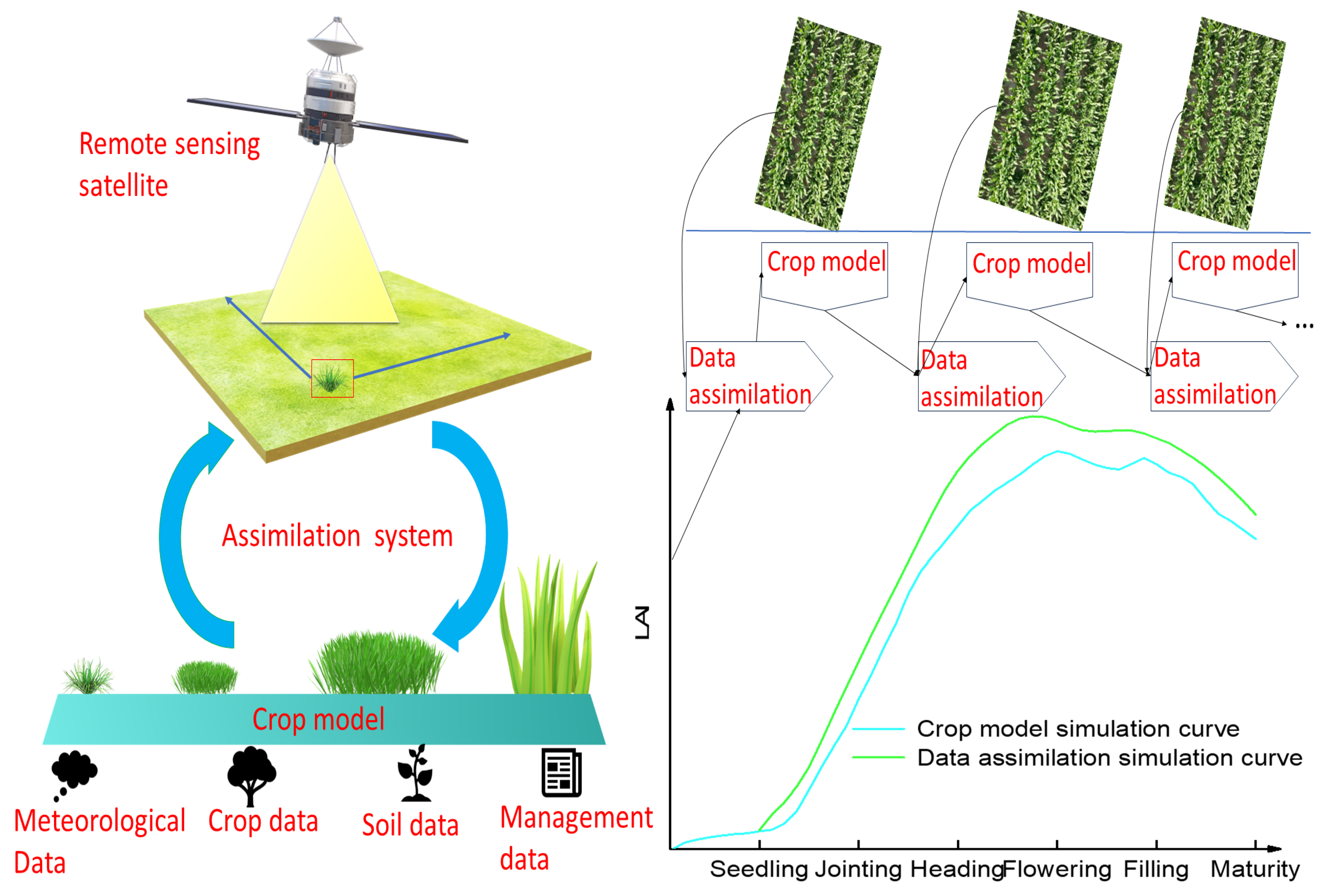
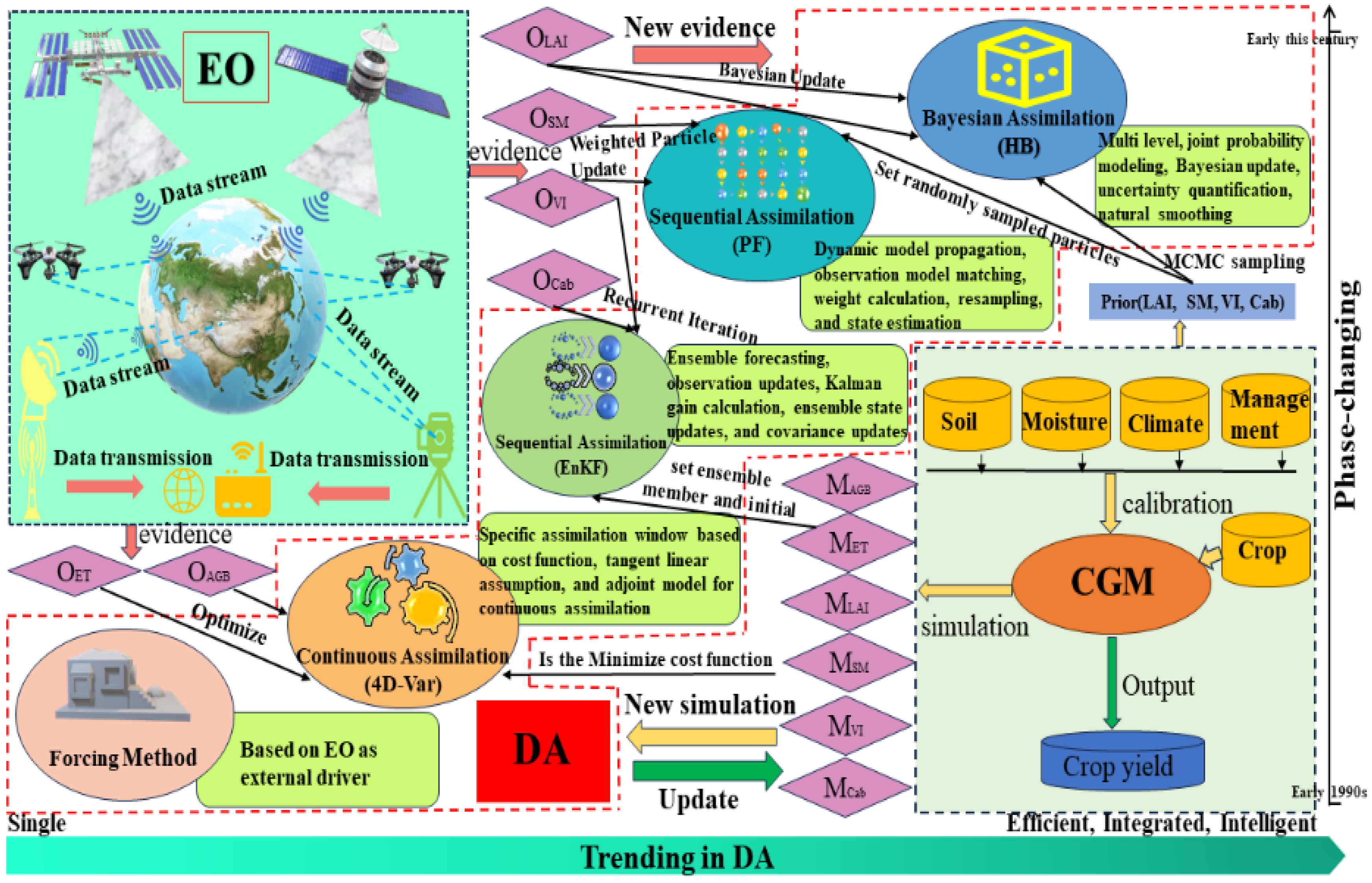

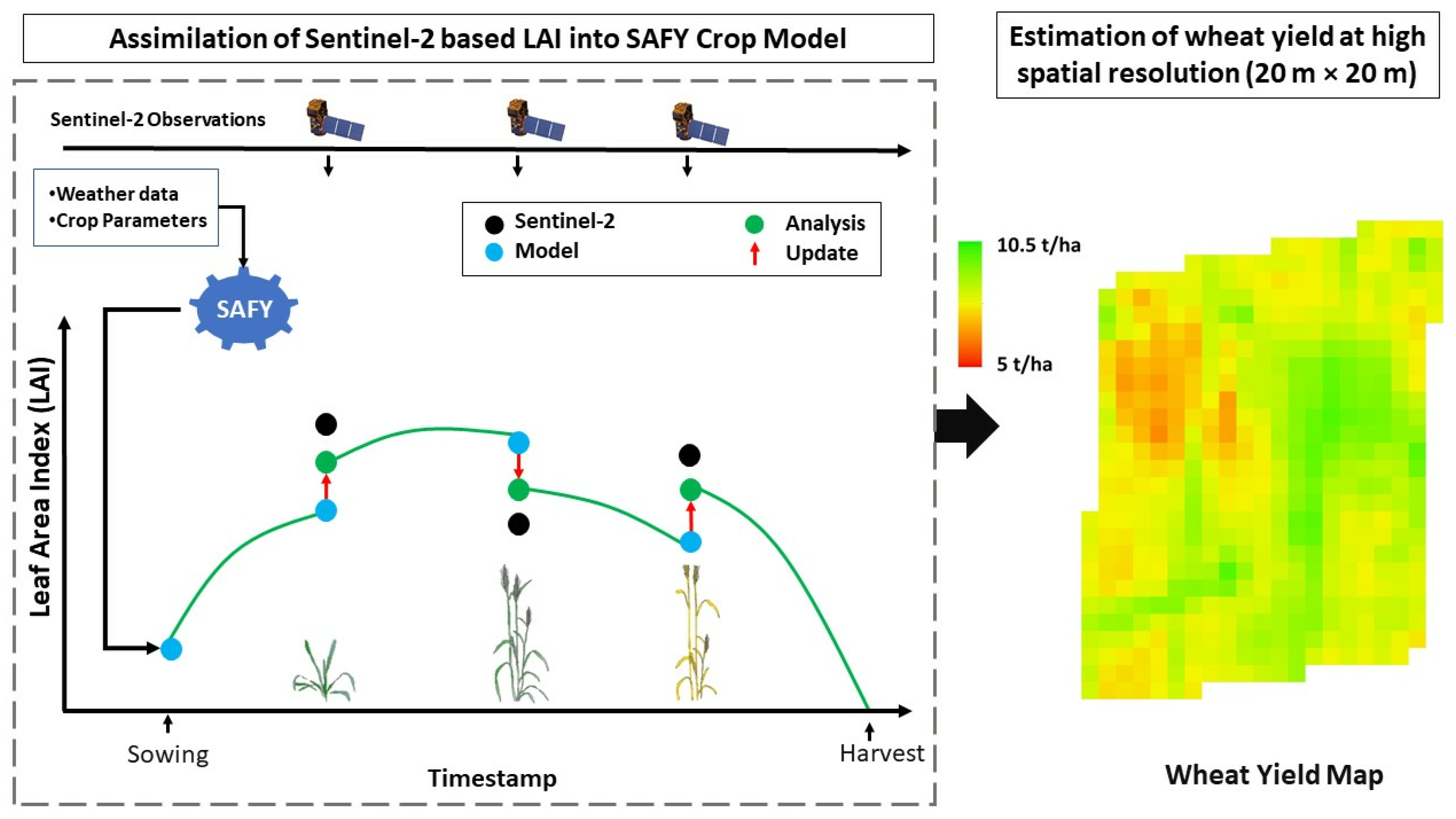
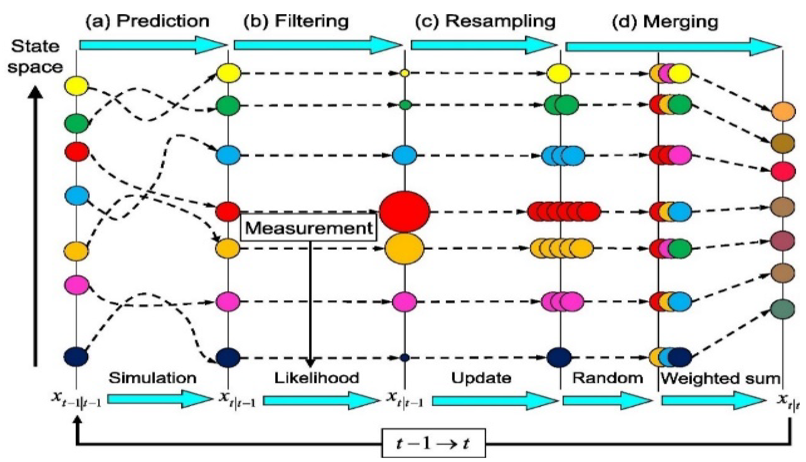


| Model Name | Application of Agricultural Assimilation | References |
|---|---|---|
| APSIM | Simulate crop growth, soil water, and nutrient dynamics and crop management practices (suitable for crops such as wheat, corn, and soybeans) | [33] |
| Agromet Shell | Simulated crop growth and yield (Prediction of crop growth and yield changes based on meteorological data) | [34] |
| Aquacrop | Response of simulated crops to water stress and yield prediction (Suitable for arid and semi-arid areas) | [35] |
| CERES-wheat | Simulate the growth and yield of wheat (Taking into account a variety of environmental and regulatory factors) | [36] |
| CROPGRO-Soybean | Simulate crop growth and yield, such as soybeans (The physiological and ecological processes of crops, soil conditions, and management measures were considered.) | [37] |
| Cropsyst | Simulate the growth, development, and yield of a variety of crops (Suitable for different climate and soil conditions) | [38] |
| DAISY | Simulate the interaction between soil moisture, nutrients, and crop growth (Suitable for farmland and paddy field management) | [39] |
| DSSAT | Simulate the growth, yield, and soil dynamics of many crops (Taking into account the impact of climate change and management practices on crops) | [40] |
| EPIC | Simulate crop growth, soil erosion, nutrient cycling (Sustainable management of agro-ecosystem) | [34] |
| GLAM | Simulated crop growth and yield are affected by global climate change (The effects of climate change on crop physiological and ecological processes were considered) | [41] |
| HERMES | Simulation of crop growth and water balance (It is especially suitable for crop management in the Mediterranean climate region) | [39] |
| STICS | Simulate crop growth, soil moisture, and nutrient dynamics (Suitable for wheat, corn, and other crops and different soil types) | [42] |
| SUCROS | Simulate the growth and yield of sugar crops, such as sugarcane (The physiological and ecological processes of crops and climatic factors were considered) | [43] |
| SWAP | Simulation of water cycle and crop growth in farmland system (Suitable for arid and semi-arid areas) | [44] |
| WOFOST | Simulation of crop growth, yield, and soil moisture dynamics (Crop physiological and ecological processes and climate change are considered) | [45] |
Disclaimer/Publisher’s Note: The statements, opinions and data contained in all publications are solely those of the individual author(s) and contributor(s) and not of MDPI and/or the editor(s). MDPI and/or the editor(s) disclaim responsibility for any injury to people or property resulting from any ideas, methods, instructions or products referred to in the content. |
© 2024 by the authors. Licensee MDPI, Basel, Switzerland. This article is an open access article distributed under the terms and conditions of the Creative Commons Attribution (CC BY) license (https://creativecommons.org/licenses/by/4.0/).
Share and Cite
Wang, J.; Wang, Y.; Qi, Z. Remote Sensing Data Assimilation in Crop Growth Modeling from an Agricultural Perspective: New Insights on Challenges and Prospects. Agronomy 2024, 14, 1920. https://doi.org/10.3390/agronomy14091920
Wang J, Wang Y, Qi Z. Remote Sensing Data Assimilation in Crop Growth Modeling from an Agricultural Perspective: New Insights on Challenges and Prospects. Agronomy. 2024; 14(9):1920. https://doi.org/10.3390/agronomy14091920
Chicago/Turabian StyleWang, Jun, Yanlong Wang, and Zhengyuan Qi. 2024. "Remote Sensing Data Assimilation in Crop Growth Modeling from an Agricultural Perspective: New Insights on Challenges and Prospects" Agronomy 14, no. 9: 1920. https://doi.org/10.3390/agronomy14091920