
Determination of Transport Pathways and Mutual Exchanges of Atmospheric Moisture between Source Regions of Yangtze and Yellow River Basins

Abstract
:1. Introduction
2. Data and Methods
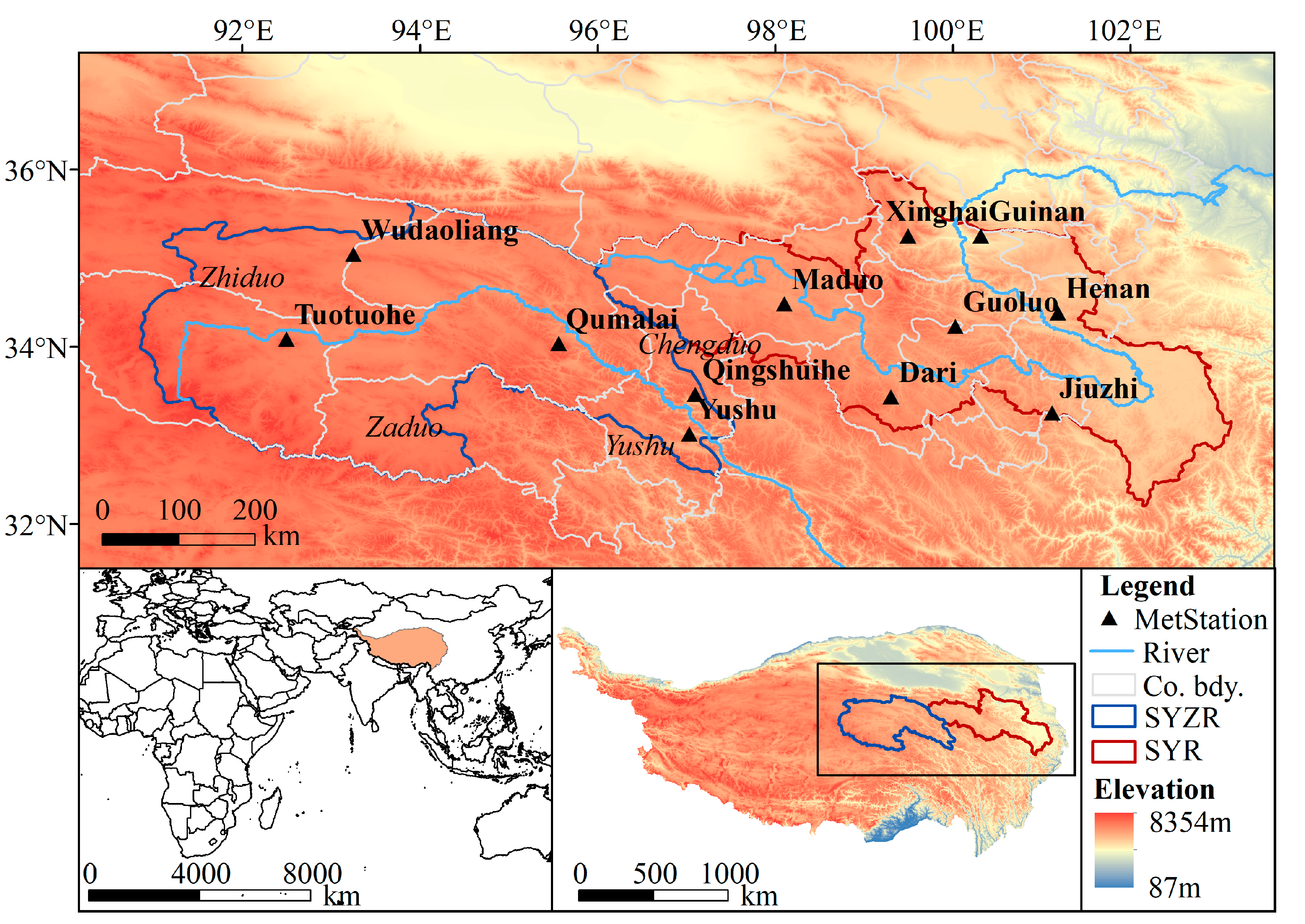
2.1. Study Area
2.2. Definition of Two Types of Daily Precipitation Events
2.3. Trajectory Generation Description
2.4. Trajectory Clustering Method
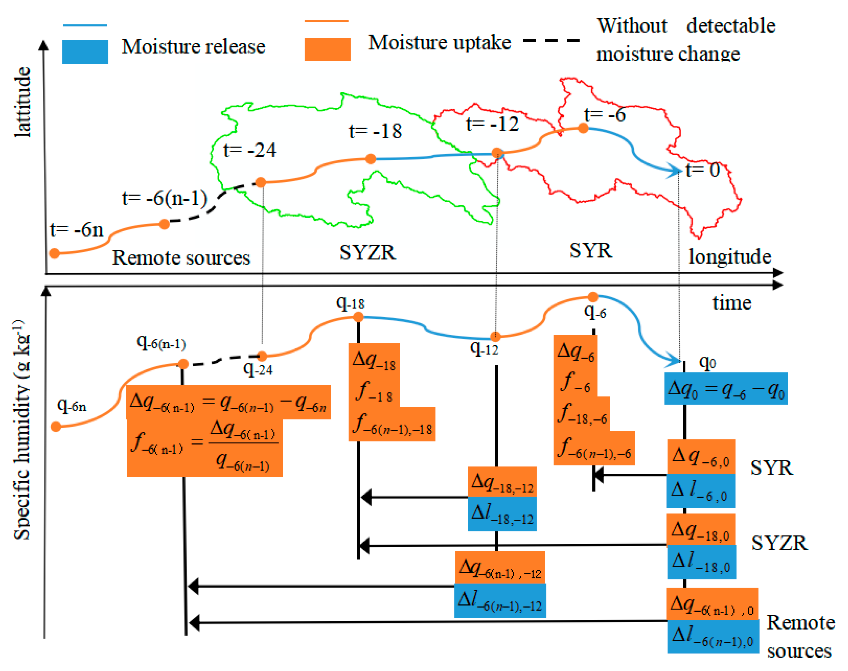
2.5. Method for Moisture Sources Attribution, Calculating Moisture Path Frequency, and Determining Average Path Humidity
- (1)
- Identify the moisture uptake and release locations along the moisture trajectory by calculating the moisture changes between neighboring time points. A threshold ec = 0.2 g∙kg−1 (6 h)−1 is set to select the moisture uptake locations with a moisture uptake amount larger than ec between the neighboring time points, as performed by Sodemann et al. [28].
- (2)
- Traverse the locations of moisture uptake, loss, and release forward in time. The initial values of the discounted moisture uptake amount Δq are set to Δl−n,0.
- (3)
- Assume we are at time = −6(n − 1), moisture uptake amounts between time = −6n and time = −6(n − 1) are Δq−6(n − 1). The moisture attribution rate by the current uptake location is f−6(n − 1). When at time = −12, which is the moisture release time, the portion of the current released moisture amount that comes from the moisture uptake at time = −6(n − 1) is Δl−6(n − 1), −12, and the remaining amounts come from the moisture uptake at time = −6(n − 1), denoted as Δq−6(n − 1), −12; the current released moisture amount attribution rate that comes from the moisture uptake at time = −6(n − 1) is f−6(n − 1), −12. When at time = 0, which is also a moisture release time, the portion of the current released moisture amount that comes from the moisture uptake at time = −6(n − 1) is Δl−6(n − 1), 0, and the remaining amounts come from the moisture uptake at time = −6(n − 1), denoted as Δq−6(n − 1),0; the current released moisture amount attribution rate that comes from the moisture uptake at time = −6(n − 1) is f−6(n − 1),0.
- (4)
- For this trajectory, the moisture sources’ attribution from remote sources, the SYZR and SYR, is Δl−6(n − 1),0, Δl−18,0, and Δl−6,0, respectively. The contributions of different moisture sources can be obtained by accumulating the moisture source attributions of all trajectories for remote sources, the SYZR, and the SYR, denoted as Δlremote_sources, ΔlSYZR, and ΔlSYR, respectively.
- (5)
- Calculate the total moisture release amount within the target region at time t = 0, denoted as Rtotal. The contribution rates of different moisture sources can be obtained by dividing the moisture source attributions of all trajectories from remote sources, the SYZR, and the SYR by Rtotal.where L is the total number of valid trajectories, and is the moisture release amounts between time = −6 and time = 0 of the i-th trajectory.
3. Results
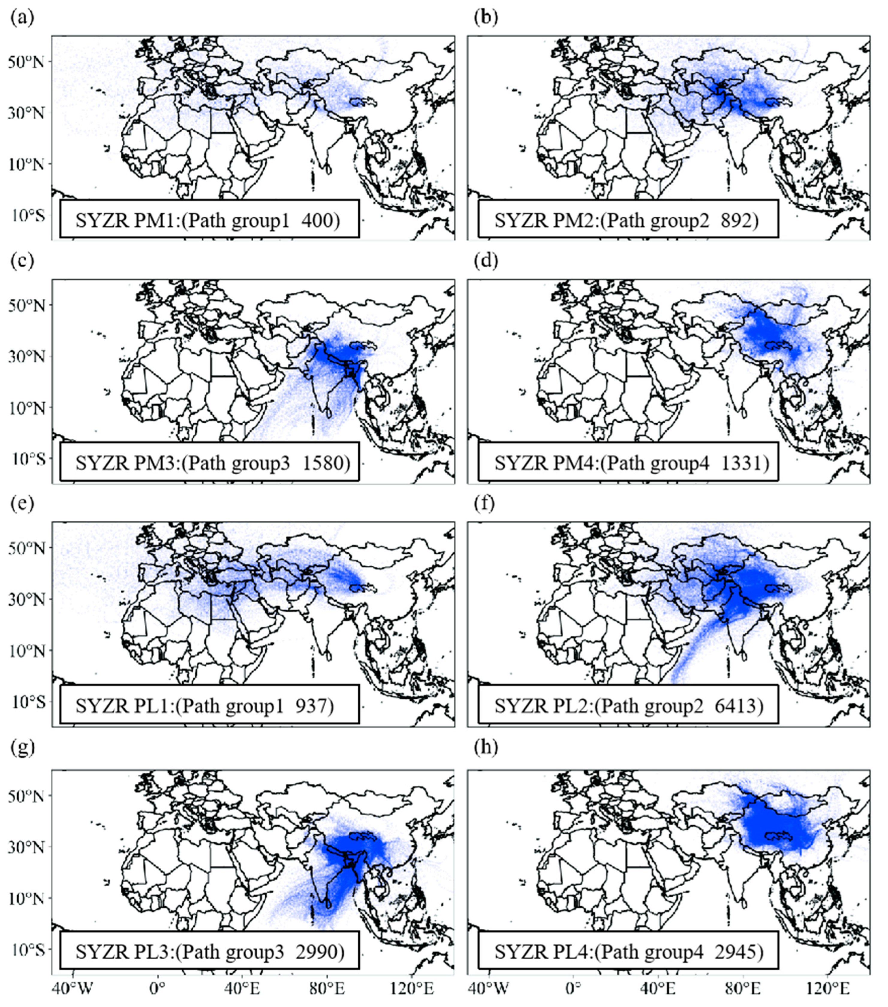
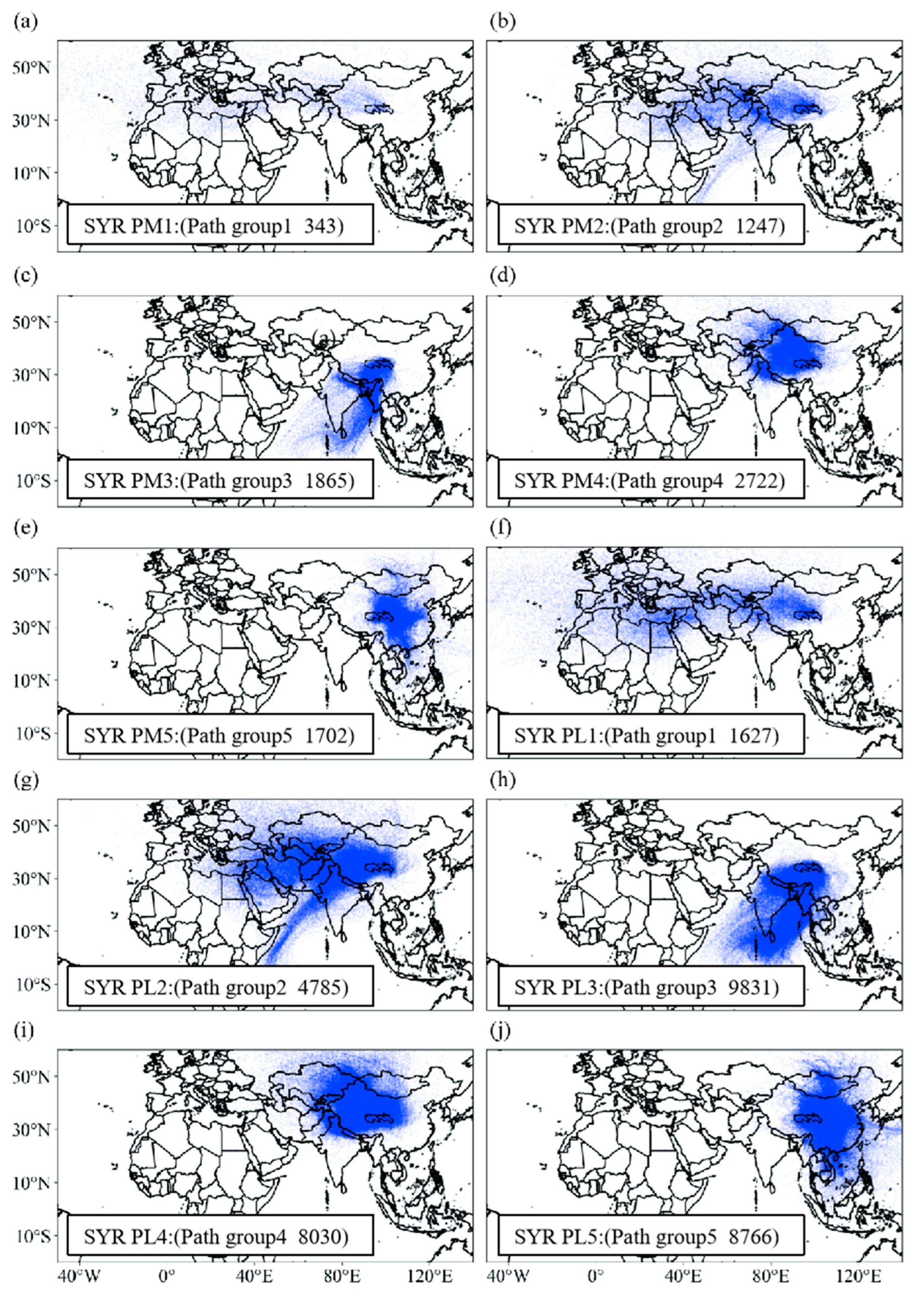
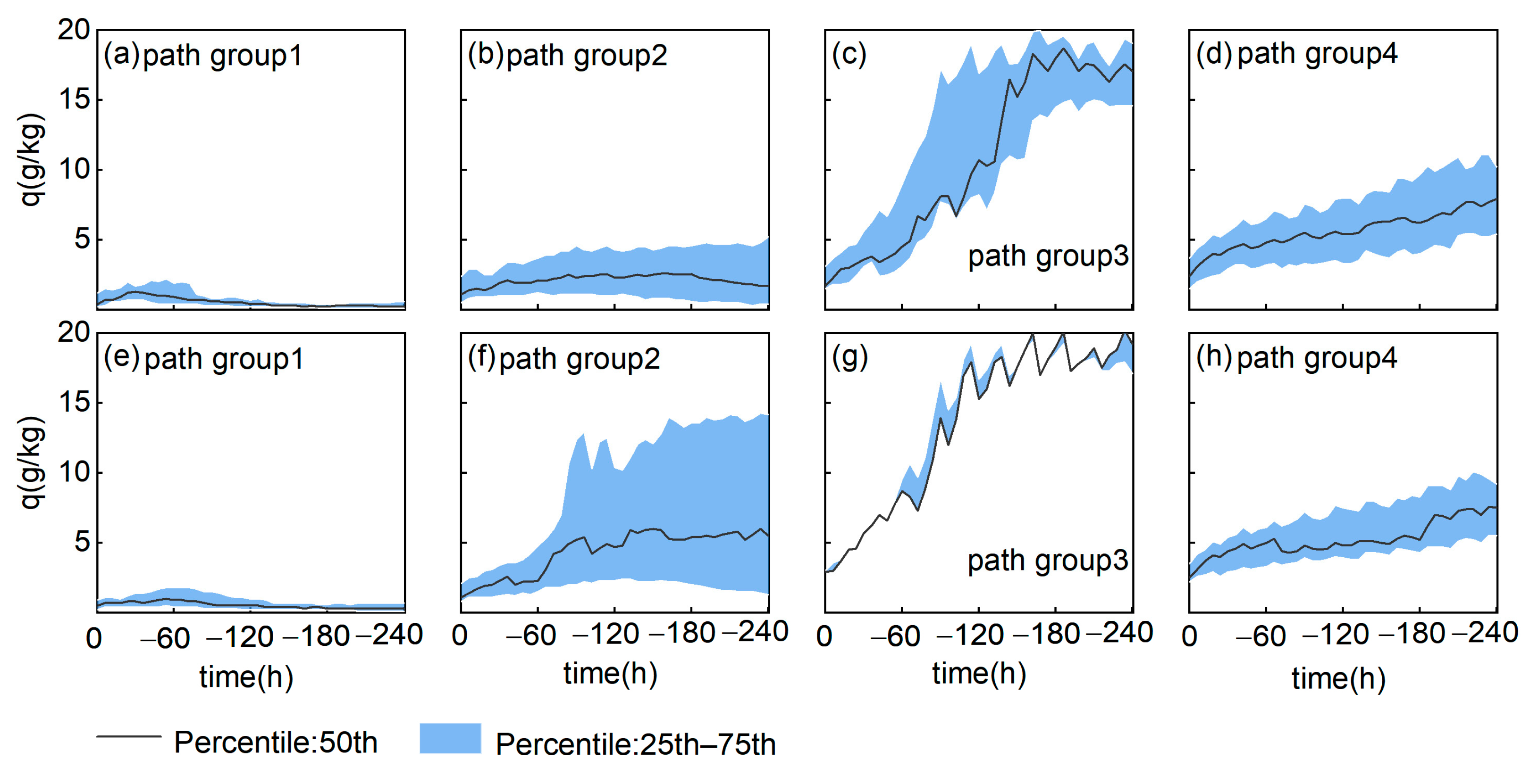
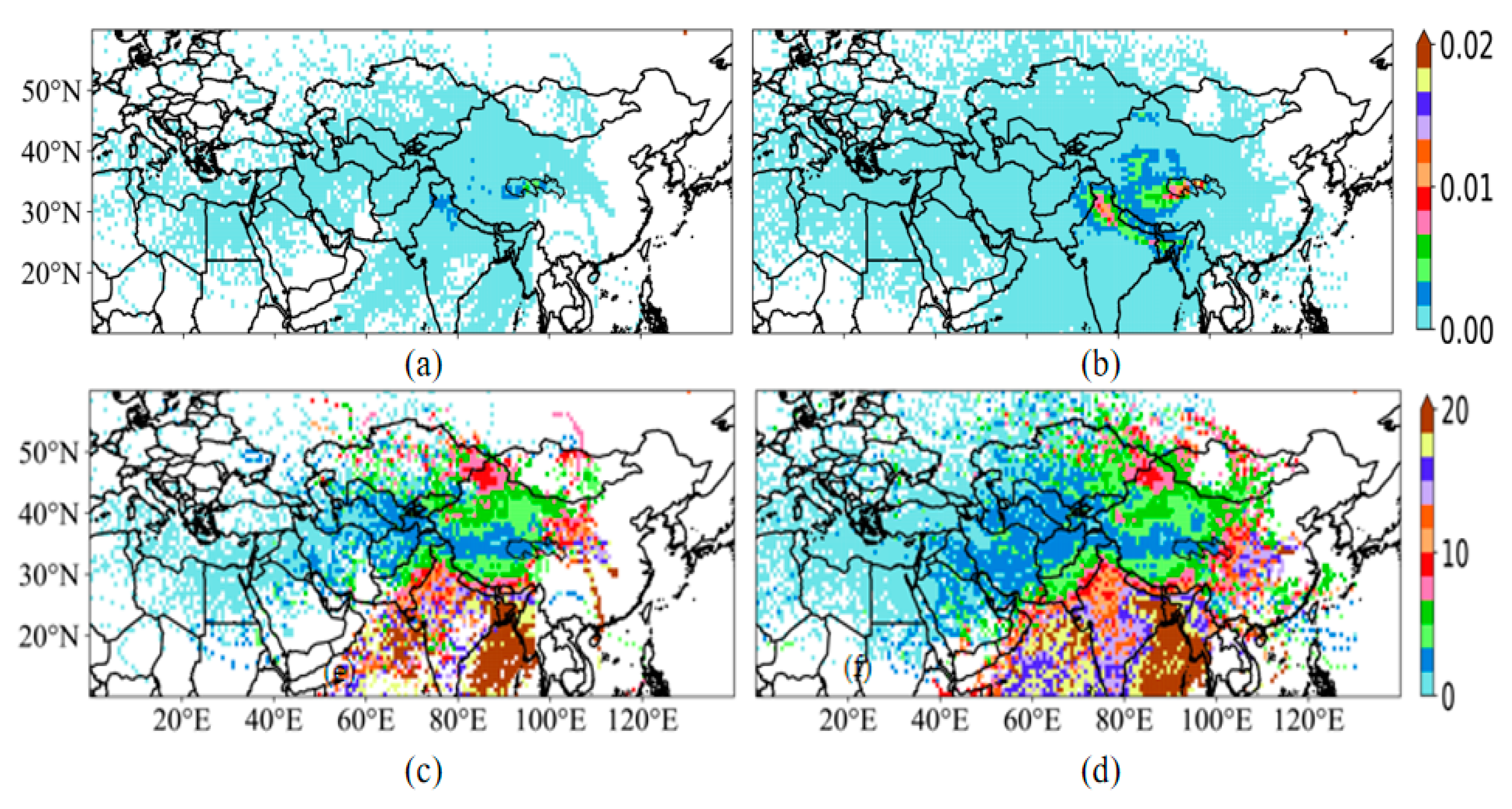
3.1. Major Moisture Transport Path Groups
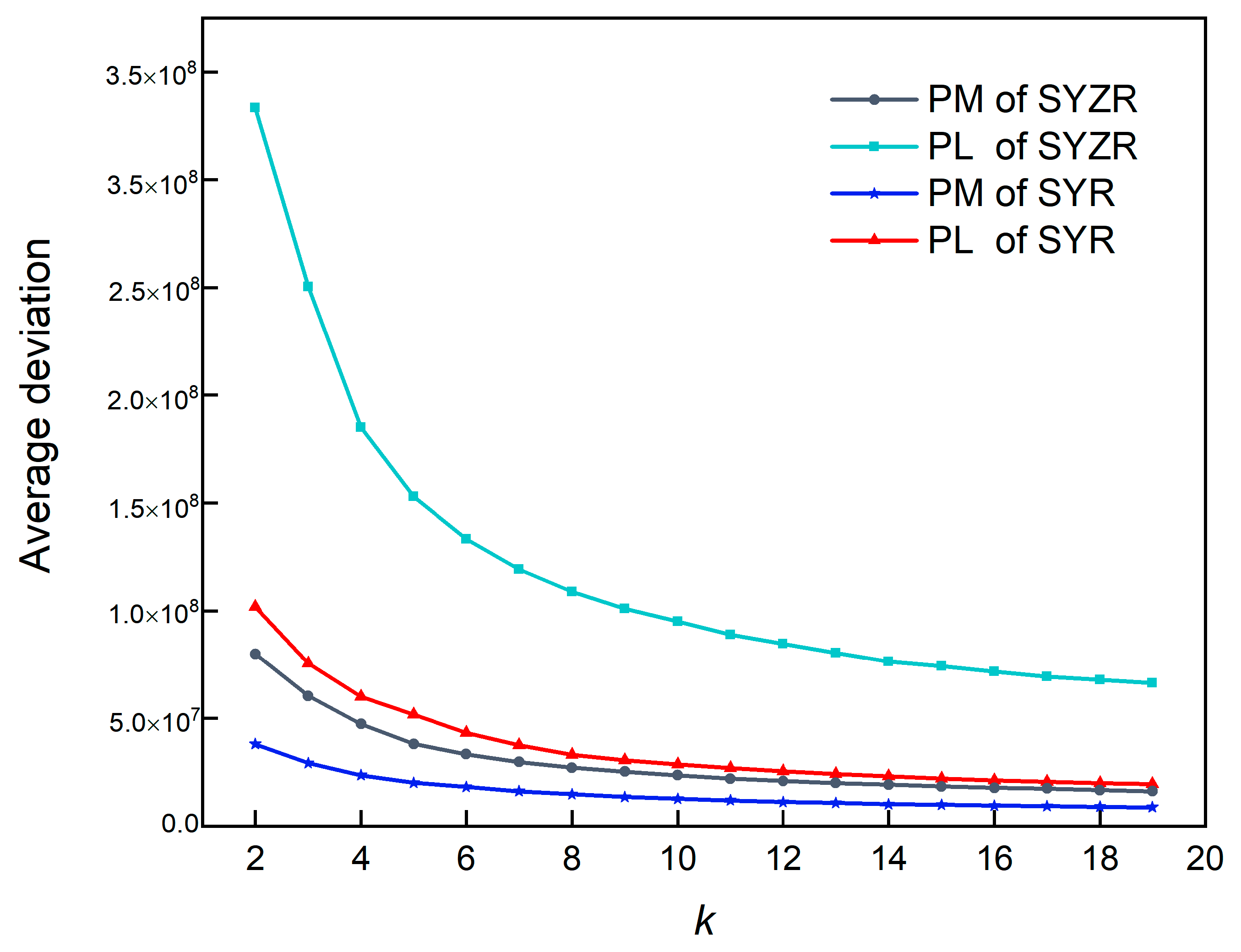
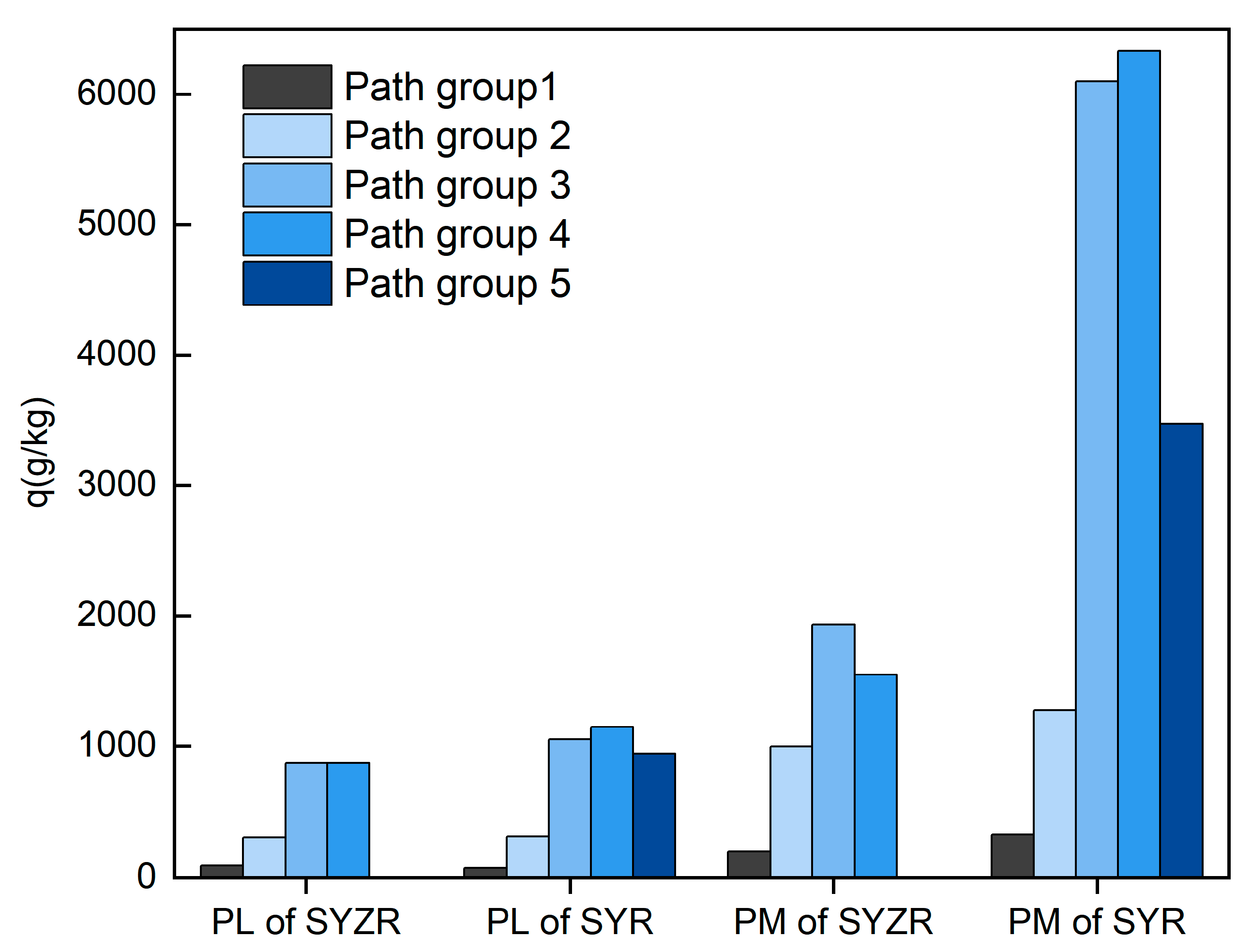
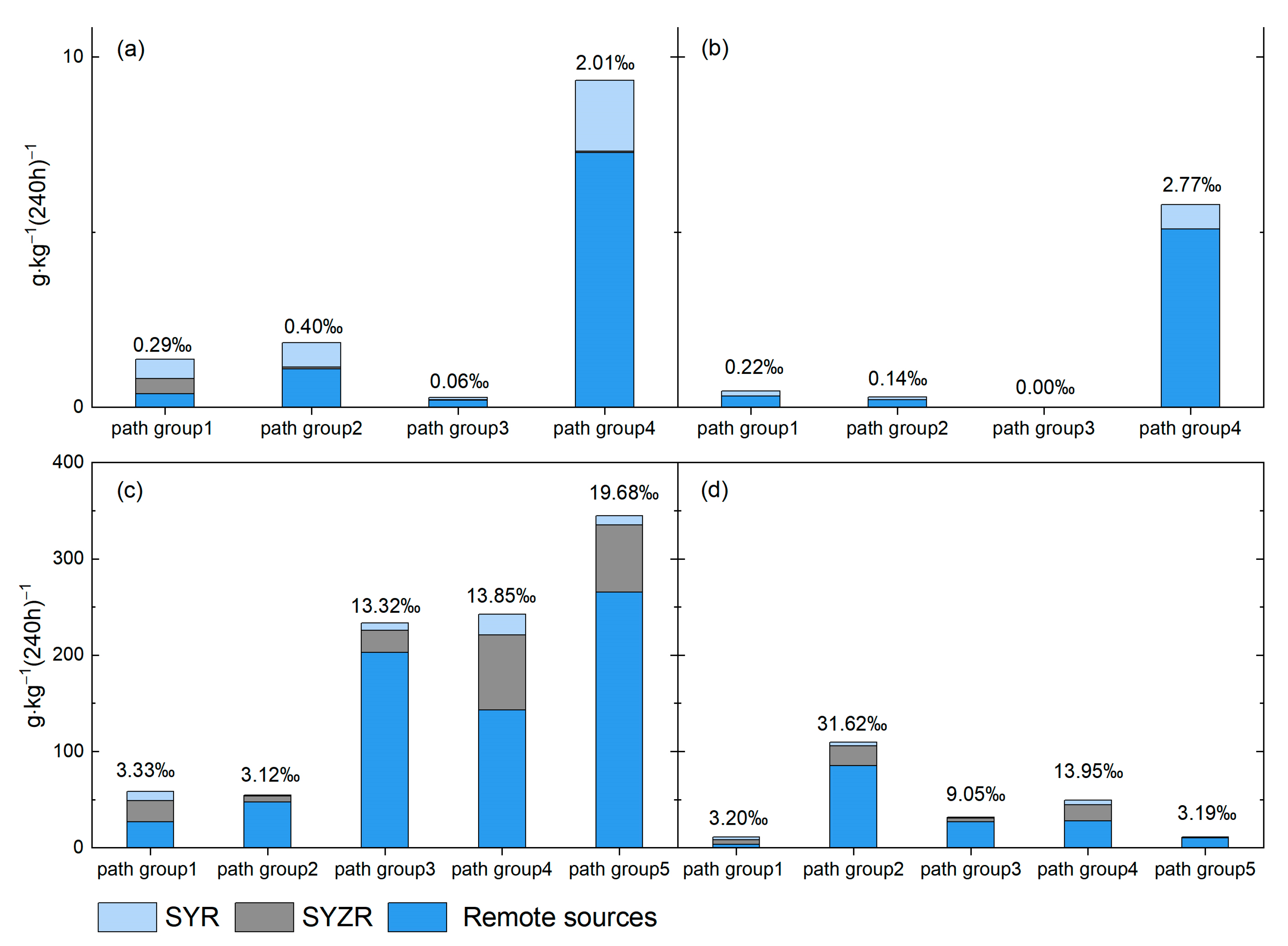
3.2. Quantitative Importance of Major Moisture Transport Path Groups
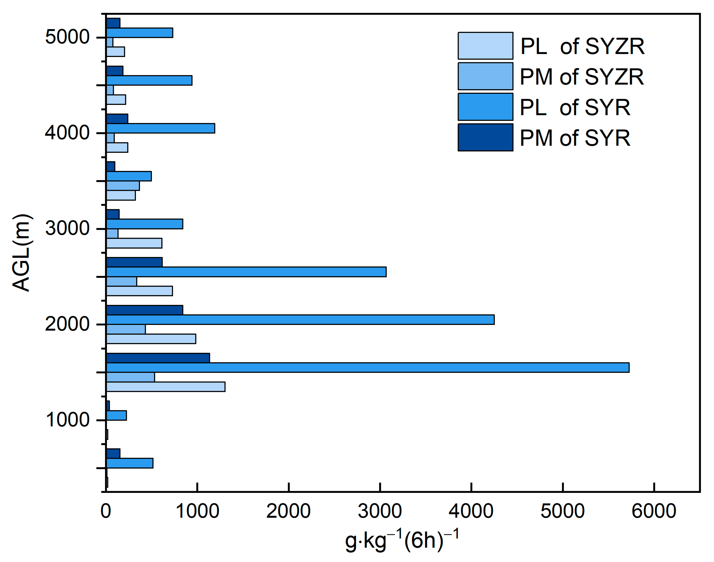
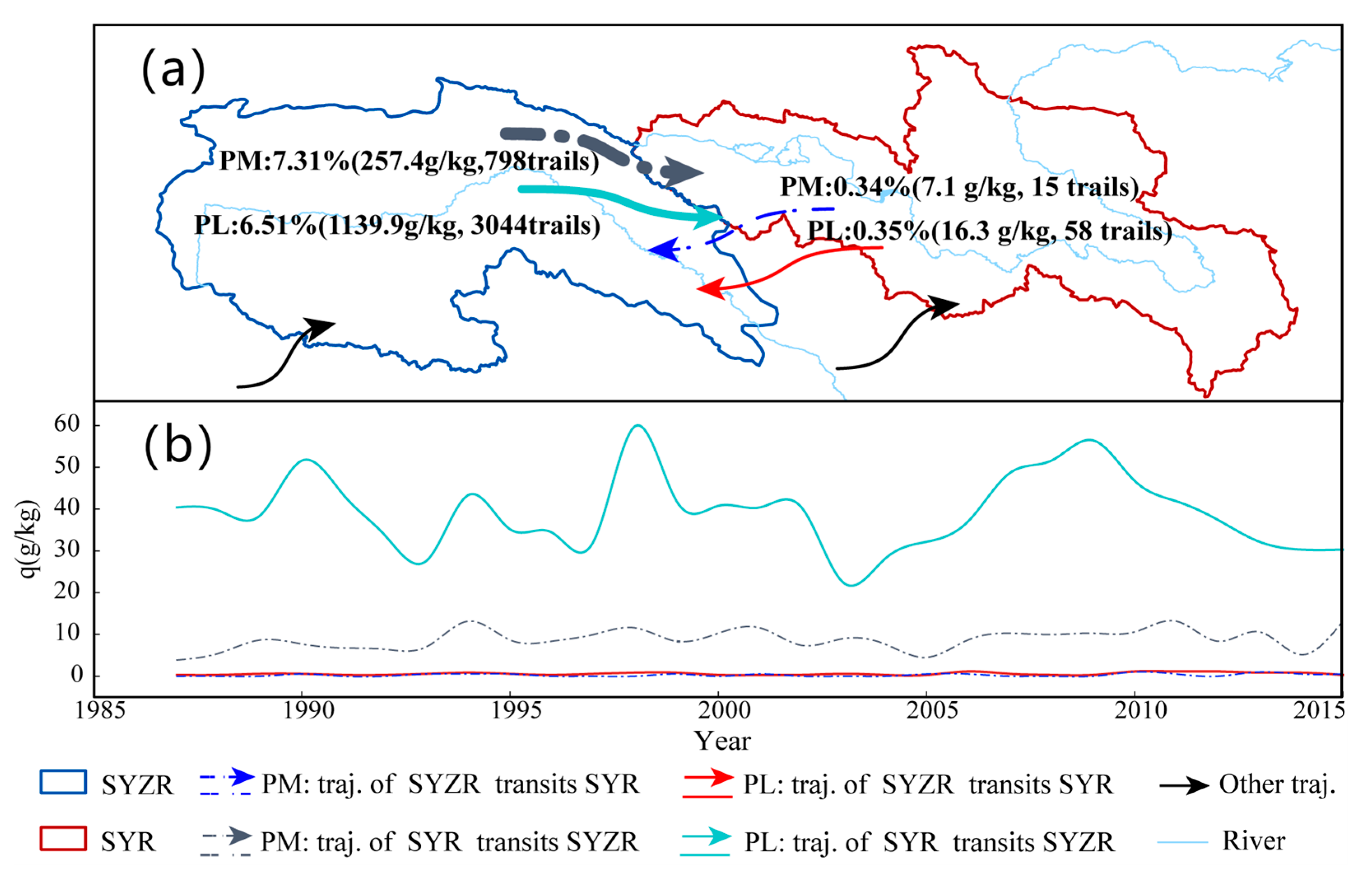
3.3. Analysis of Moisture Exchange between the SYZR and SYR
4. Conclusions and Discussion
4.1. Conclusions
4.2. Discussion
Author Contributions
Funding
Institutional Review Board Statement
Informed Consent Statement
Data Availability Statement
Conflicts of Interest
Appendix A


| Region | Event | K = 2 | K= 3 | K = 4 | K= 5 | K = 6 | K = 7 | K= 8 |
|---|---|---|---|---|---|---|---|---|
| SYZR | PM | 0.513 | 0.295 | 0.320 | 0.313 | 0.313 | 0.311 | 0.314 |
| PL | 0.587 | 0.410 | 0.433 | 0.427 | 0.461 | 0.472 | 0.477 | |
| SYR | PM | 0.490 | 0.332 | 0.361 | 0.368 | 0.365 | 0.355 | 0.356 |
| PL | 0.488 | 0.328 | 0.374 | 0.376 | 0.373 | 0.353 | 0.357 |
References
- Wang, Y.; Ding, Y.; Ye, B.; Liu, F.; Wang, J.; Wang, J. Contributions of climate and human activities to changes in runoff of the Yellow and Yangtze rivers from 1950 to 2008. Sci. China Earth Sci. 2012, 56, 1398–1412. [Google Scholar] [CrossRef]
- Ayantobo, O.O.; Wei, J.; Shi, Y.; Wang, G. Climatological changes in rainfall distributions at different rain-rates under Qinghai-Tibet Plateau warming during 1981–2060. Theor. Appl. Climatol. 2023, 152, 663–679. [Google Scholar] [CrossRef]
- Wei, J. A Research Report on Sanjiangyuanecological Protection: Volume of Hydrology and Water Resources; Social Sciences Academic Press: Beijing, China, 2017; p. 2. [Google Scholar]
- Lu, W.; Wang, W.; Shao, Q.; Yu, Z.; Hao, Z.; Xing, W.; Yong, B.; Li, J. Hydrological projections of future climate change over the source region of Yellow River and Yangtze River in the Tibetan Plateau: A comprehensive assessment by coupling RegCM4 and VIC model. Hydrol. Process. 2018, 32, 2096–2117. [Google Scholar] [CrossRef]
- Cao, L.; Pan, S. Changes in precipitation extremes over the “Three-River Headwaters” region, hinterland of the Tibetan Plateau, during 1960–2012. Quat. Int. 2014, 321, 105–115. [Google Scholar] [CrossRef]
- Hu, Y.; Zhou, Y.; Wang, Y.; Lu, F.; Xiao, W.; Hou, B.; Yu, Y.; Liu, J.; Xue, W. Impacts of Precipitation Type Variations on Runoff Changes in the Source Regions of the Yangtze and Yellow River Basins in the Past 40 Years. Water 2022, 14, 4115. [Google Scholar] [CrossRef]
- Tang, Q.; Liu, Y.; Zhang, C.; Su, F.; Li, Y.; Gao, Y.; Li, W.; Chen, D. Research progress on moisture source change of precipitation over the Tibetan Plateau and its surrounding areas. Trans. Atmos. Sci. 2020, 43, 1002–1009. [Google Scholar] [CrossRef]
- Li, H.; Pan, X. An overview of research methods on water vapor transport and sources in the Tibetan Plateau. Adv. Earth Sci. 2022, 37, 1025–1036. [Google Scholar]
- Shi, X.; Shi, X. Climatic characteristics of water vapor budget over southeastern Tibetan Plateau in summer and their effects. JAMS 2008, 19, 41–46. [Google Scholar]
- Qiang, A.; Wang, N.; Xie, J.; Wei, J. Analysis of Water Vapor Change and Precipitation Conversion Efficiency Based on HYSPLIT Backward Trajectory Model over the Three-River Headwaters Region. J. Coast. Res. 2020, 105, 6–11. [Google Scholar] [CrossRef]
- Ayantobo, O.O.; Wei, J.; Hou, M.; Xu, J.; Wang, G. Characterizing potential sources and transport pathways of intense moisture during extreme precipitation events over the Tibetan Plateau. J. Hydrol. 2022, 615, 128734. [Google Scholar] [CrossRef]
- Xu, N.; Zhong, L.; Ma, Y.; Zou, M.; Huang, Z. A study on the water vapor transport trend and water vapor source of the Tibetan Plateau. Theor. Appl. Climatol. 2020, 140, 1031–1042. [Google Scholar] [CrossRef]
- Zhang, Y.; Huang, W.; Zhong, D. Major Moisture Pathways and Their Importance to Rainy Season Precipitation over the Sanjiangyuan Region of the Tibetan Plateau. J. Clim. 2019, 32, 6837–6857. [Google Scholar] [CrossRef]
- Tang, Q.; Zhang, C.; Chen, D. Recent Changes in the Moisture Source of Precipitation over the Tibetan Plateau. J. Clim. 2017, 30, 1807–1819. [Google Scholar] [CrossRef]
- Zhu, L.; Liu, R.; Wang, X.; Wang, Z.; Wen, J.; Zhao, Y.; Xie, Y.; Zhang, T. The characteristics of the water vapor transport and associated sources under abnormal precipitation conditions in the source region of the Yellow River using FLEXPART. Plateau Meteorol. 2019, 38, 484–496. [Google Scholar] [CrossRef]
- Li, J.; Li, T.; Wang, G.; Wei, J.; Zhong, D.; Su, Y.; Fu, X. Atmospheric water resource and precipitation conversion. Chin. Sci. Bull. 2018, 63, 2785–2796. [Google Scholar] [CrossRef]
- Ren, Z.H.; Zou, F.L.; Yu, Y.; Wang, G.A.; Zhang, Z.F.; Fan, S.H.; Zhang, Z.Q.; Sun, C. Dataset of Daily Climate Data from Chinese Surface Stations, Version 3.0. National Meteorological Information Center. Available online: https://data.cma.cn/data/cdcindex/cid/f0fb4b55508804ca.html (accessed on 5 January 2018).
- GB/T 28592-2012 Grade of Precipitation; General Administration of Quality Super Vision, Inspection and Quarantine of the People and Republic of China. Standards Press of China: Beijing, China, 2012.
- Yatagai, A.; Namiguchi, N.; Arakawa, O.; Hamada, A.; Yasutomi, N.; Nitoh, A. APHRODITE: Constructing a Long-Term Daily Gridded Precipitation Dataset for Asia Based on a Dense Network of Rain Gauges. Bull. Am. Meteorl. Soc. 2012, 93, 1401–1415. [Google Scholar] [CrossRef]
- Draxler, R.R.; Hess, G.D. Description of the HYSPLIT_4 Modeling System; NOAA Technical Memorandum ERL ARL-224; National Oceanic and Atmospheric Administration: Washington, DC, USA, 1997; 224p. [Google Scholar]
- Draxler, R.R.; Hess, G.D. An overview of the HYSPLIT_4 modelling system for trajectories, dispersion, and deposition. Aust. Meteorol. Mag. 1998, 47, 295–308. [Google Scholar]
- Wagner, T.; Andreae, M.O.; Beirle, S.; Dörner, S.; Mies, N.; Shaiganfar, R. MAX-DOAS observations of the total atmospheric water vapour column and comparison with independent observations. Atmos. Meas. Tech. 2013, 6, 131–149. [Google Scholar] [CrossRef]
- Trenberth, N.E. Atmospheric Moisture Recycling: Role of Advection and Local Evaporation. J. Clim. 1999, 12, 1368–1381. [Google Scholar] [CrossRef]
- Trenberth, N.E. Atmospheric Moisture Residence Times and Cycling: Implications for Rainfall Rates and Climate Change. Clim. Chang. 1998, 39, 667–694. [Google Scholar] [CrossRef]
- Cohen, M.D.; Stunder, B.J.B.; Rolph, G.D.; Draxler, R.R.; Stein, A.F.; Ngan, F. NOAA’s HYSPLIT Atmospheric Transport and Dispersion Modeling System. Bull. Am. Meteorol. Soc. 2015, 96, 2059–2077. [Google Scholar] [CrossRef]
- Rousseeuw, P.J. Silhouettes: A graphical aid to the interpretation and validation of cluster analysis. J. Comput. Appl. Math. 1987, 20, 53–65. [Google Scholar] [CrossRef]
- Sodemann, H.; Schwierz, C.; Wernli, H. Interannual variability of Greenland winter precipitation sources: Lagrangian moisture diagnostic and North Atlantic Oscillation influence. J. Geophys. Res. 2008, 113, D03107. [Google Scholar] [CrossRef]
- Sun, B.; Wang, H. Moisture Sources of Semiarid Grassland in China Using the Lagrangian Particle Model FLEXPART. J. Clim. 2014, 27, 2457–2474. [Google Scholar] [CrossRef]
- Wahlgren, R.V. Atmospheric water vapour processor designs for potable water production: A review. Water Res 2001, 35, 1–22. [Google Scholar] [CrossRef]
- Flossmann, A.I.; Manton, M.; Abshaev, A.; Bruintjes, R.; Murakami, M.; Prabhakaran, T.; Yao, Z. Review of Advances in Precipitation Enhancement Research. Bull. Am. Meteorol. Soc. 2019, 100, 1465–1480. [Google Scholar] [CrossRef]
- Liu, R.; Wang, X.; Wang, Z. Atmospheric moisture sources of drought and wet events during 1979–2019 in the Three-River Source Region, Qinghai-Tibetan Plateau. Theor. Appl. Climatol. 2022, 149, 487–499. [Google Scholar] [CrossRef]
- Borge, R.; Lumbreras, J.; Vardoulakis, S.; Nassomenos, P.; Rodriguez, E. Analysis of long-range transport influences on urban PM10 using two-stage atmospheric trajectory clusters. Atmos. Environ. 2007, 41, 4434–4450. [Google Scholar] [CrossRef]


| Grade | Extra Heavy Rainstorm | Heavy Rainstorm | Rainstorm | Heavy Precipitation | Moderate Precipitation | Light Precipitation |
|---|---|---|---|---|---|---|
| 24 h Precipitation Amount (mm) | ≥250 | 100–249.9 | 50–99.9 | 25–49.9 | 10–24.9 | 0.1–9.9 |
| Proportion (%) | 0.30 | 6.96 | 39.38 | 53.37 | ||
| Region | No. of Grids | Event | Mean Precipitation Rate (mm/d) | No. of Events (Average Times/Grid Points) | No. of Traj. | No. of Valid Traj. |
|---|---|---|---|---|---|---|
| Source Region of Yangtze River (SYZR) | 26 | PM | 14.51 | 48.04 | 12,560 | 4203 |
| PL | 4.41 | 409.19 | 32,260 | 13,285 | ||
| Source Region of Yellow River (SYR) | 28 | PM | 15.25 | 127.13 | 29,190 | 7429 |
| PL | 4.61 | 669.96 | 130,970 | 33,039 |
Disclaimer/Publisher’s Note: The statements, opinions and data contained in all publications are solely those of the individual author(s) and contributor(s) and not of MDPI and/or the editor(s). MDPI and/or the editor(s) disclaim responsibility for any injury to people or property resulting from any ideas, methods, instructions or products referred to in the content. |
© 2024 by the authors. Licensee MDPI, Basel, Switzerland. This article is an open access article distributed under the terms and conditions of the Creative Commons Attribution (CC BY) license (https://creativecommons.org/licenses/by/4.0/).
Share and Cite
Kang, B.; Wei, J.; Ayantobo, O.O.; Yang, H. Determination of Transport Pathways and Mutual Exchanges of Atmospheric Moisture between Source Regions of Yangtze and Yellow River Basins. Atmosphere 2024, 15, 524. https://doi.org/10.3390/atmos15050524
Kang B, Wei J, Ayantobo OO, Yang H. Determination of Transport Pathways and Mutual Exchanges of Atmospheric Moisture between Source Regions of Yangtze and Yellow River Basins. Atmosphere. 2024; 15(5):524. https://doi.org/10.3390/atmos15050524
Chicago/Turabian StyleKang, Beiming, Jiahua Wei, Olusola O. Ayantobo, and Haijiao Yang. 2024. "Determination of Transport Pathways and Mutual Exchanges of Atmospheric Moisture between Source Regions of Yangtze and Yellow River Basins" Atmosphere 15, no. 5: 524. https://doi.org/10.3390/atmos15050524