Next Issue
Volume 10, December
Previous Issue
Volume 10, October
 
 
water-logo

Journal Browser

Journal Browser

Water, Volume 10, Issue 11 (November 2018) – 212 articles

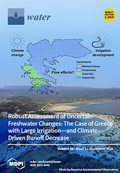
Cover Story (view full-size image): We synthesize climate, hydrological, and human land- and water-use data with the aim to decipher key changes and their drivers for freshwater availability and flux balance in five nested catchments across Greece. Changes are assessed from an early (1930–1949) to a recent (1990–2009) period, with different climate (particularly less precipitation) and human influence (particularly more irrigated agriculture) conditions in the latter. We find that the precipitation change has driven decrease while the irrigation development has driven increase in evapotranspiration, leading to a net total increase of 26 ± 7 mm/year on average over Greece. For average runoff over Greece, draining to different parts of the Mediterranean Sea, both drivers have contributed more or less equally to a considerable total decrease of −75 ± 10 mm/year. View Paper here.
  • Issues are regarded as officially published after their release is announced to the table of contents alert mailing list.
  • You may sign up for e-mail alerts to receive table of contents of newly released issues.
  • PDF is the official format for papers published in both, html and pdf forms. To view the papers in pdf format, click on the "PDF Full-text" link, and use the free Adobe Reader to open them.
Order results
Result details
Section
Select all
Export citation of selected articles as:
16 pages, 3633 KiB  
Article
Hydrological Simulation and Runoff Component Analysis over a Cold Mountainous River Basin in Southwest China
by Weidong Xuan, Qiang Fu, Guanghua Qin, Cong Zhu, Suli Pan and Yue-Ping Xu
Water 2018, 10(11), 1705; https://doi.org/10.3390/w10111705 - 21 Nov 2018
Cited by 16 | Viewed by 3982
Abstract
Assessment of water resources from mountainous catchments is crucial for the development of upstream rural areas and downstream urban communities. However, lack of data in these mountainous catchments prevents full understanding of the response of hydrology or water resources to climate change. Meanwhile, [...] Read more.
Assessment of water resources from mountainous catchments is crucial for the development of upstream rural areas and downstream urban communities. However, lack of data in these mountainous catchments prevents full understanding of the response of hydrology or water resources to climate change. Meanwhile, hydrological modeling is challenging due to parameter uncertainty. In this work, one tributary of the Yarlung Zangbo River Basin (the upper stream of the Brahmaputra River) was used as a case study for hydrological modeling. Tropical Rainfall Measuring Mission (TRMM 3B42V7) data were utilized as a substitute for gauge-based rainfall data, and the capability of simulating precipitation, snow, and groundwater contributions to total runoff by the Soil and Water Assessment Tool (SWAT) was investigated. The uncertainty in runoff proportions from precipitation, snowmelt, and groundwater was quantified by a batch-processing module. Hydrological signatures were finally used to help identify if the hydrological model simulated total runoff and corresponding proportions properly. The results showed that: (1) TRMM data were very useful for hydrological simulation in high and cold mountainous catchments; (2) precipitation was the primary contributor nearly all year round, reaching 56.5% of the total runoff on average; (3) groundwater occupied the biggest proportion during dry seasons, whereas snowmelt made a substantial contribution only in late spring and summer; and (4) hydrological signatures were useful for helping to evaluate the performance of the hydrological model. Full article
(This article belongs to the Special Issue Hydrological Processes under Environmental Change)
Show Figures

Figure 1

20 pages, 1969 KiB  
Article
Capacity Building for Water Management in Peri-Urban Communities, Bangladesh: A Simulation-Gaming Approach
by Sharlene L. Gomes, Leon M. Hermans, Kazi Faisal Islam, Sheikh Nazmul Huda, ATM Zakir Hossain and Wil A. H. Thissen
Water 2018, 10(11), 1704; https://doi.org/10.3390/w10111704 - 21 Nov 2018
Cited by 27 | Viewed by 6761
Abstract
Peri-urban areas in the global south are experiencing over-exploitation and contamination of water resources as a result of rapid urbanisation. These problems relate to the ineffectiveness of the underlying institutions in this dynamic, multi-actor context. Institutions need to be considered during problem solving; [...] Read more.
Peri-urban areas in the global south are experiencing over-exploitation and contamination of water resources as a result of rapid urbanisation. These problems relate to the ineffectiveness of the underlying institutions in this dynamic, multi-actor context. Institutions need to be considered during problem solving; however, peri-urban communities have limited insight into their institutional context. This research examines the extent to which problem solving capacity can be improved through gaming-simulation methods. A game-based approach is tested in a capacity building workshop with peri-urban communities in Khulna (Bangladesh). A role-playing game designed from game theory models is used to examine local drinking water problems through an institutional lens. Workshop evaluation shows that through role-play, participants learned about strategies in drinking water supply (in both the current and future scenarios) and about the potential to address water quality issues through cooperative groundwater monitoring. Results also show improved problem understanding with regards to institutions, actor strategies, and problem-solving constraints. Participants valued the interactive medium for comparing and evaluating strategies. This paper highlights limitations in game design and its implementation, and offers ways to address this in future applications. Full article
Show Figures

Figure 1

14 pages, 2179 KiB  
Article
Anthropogenic Impact and Ecological Risk Assessment of Thallium and Cobalt in Poyang Lake Using the Geochemical Baseline
by Yanyan Li, Xiaodong Qu, Min Zhang, Wenqi Peng, Yang Yu and Bo Gao
Water 2018, 10(11), 1703; https://doi.org/10.3390/w10111703 - 21 Nov 2018
Cited by 28 | Viewed by 3803
Abstract
As the largest freshwater lake in China, water environmental pollution in Poyang Lake is increasingly attracting attention. However, to date, the occurrence of seldom-monitored trace elements (SMTEs) (such as thallium (Tl) and cobalt (Co)) and their potential ecological influences in the Poyang Lake [...] Read more.
As the largest freshwater lake in China, water environmental pollution in Poyang Lake is increasingly attracting attention. However, to date, the occurrence of seldom-monitored trace elements (SMTEs) (such as thallium (Tl) and cobalt (Co)) and their potential ecological influences in the Poyang Lake area remain unclear. Here, geochemical baseline concentrations (GBCs) were employed to investigate anthropogenic inputs of these two metals (Tl and Co) and were used to assess the potential ecological risk in surface sediments of Poyang Lake. The results showed that the mean concentrations of Tl and Co were 1.11 mg/kg and 15.42 mg/kg, respectively, slightly higher than background values (BVs) in local soil. Spatially, the Co concentrations in surface sediments of Poyang Lake varied; Co concentrations in the west of the study area were significantly lower than in the middle of the lake. In contrast, no significant spatial variation of Tl was found in studied areas of Poyang Lake. Average GBCs were similar to the mean measured concentrations of Tl and Co in the lake, and both were higher than the BVs in local soil. In anthropogenic source analysis based on the GBCs, 47.22% samples and 41.67% samples were influenced by human activity for Tl and Co, respectively; the mean anthropogenic contribution rate was 5.90% for Tl (0.43 to 16.22%), and 13.01% for Co (0.82 to 31.59%). These results indicated that Tl and Co mainly originate from natural processes. However, the anthropogenic contribution should not be ignored. Moreover, the geo-accumulation index (Igeo) and potential ecological parameter (Er) generally indicated no contamination and a low potential risk for Tl and Co in Poyang Lake sediments, which used the GBCs as BVs. The results of this study suggest that GBCs are more scientifically robust and practical as a reference than BVs. They can also be used when BVs are lacking. Full article
(This article belongs to the Section Water Quality and Contamination)
Show Figures

Figure 1

20 pages, 8252 KiB  
Article
Synthetic Impacts of Internal Climate Variability and Anthropogenic Change on Future Meteorological Droughts over China
by Lei Gu, Jie Chen, Chong-Yu Xu, Hui-Min Wang and LiPing Zhang
Water 2018, 10(11), 1702; https://doi.org/10.3390/w10111702 - 21 Nov 2018
Cited by 12 | Viewed by 4541
Abstract
The climate change impacts on droughts have received widespread attention in many recent studies. However, previous studies mainly attribute the changes in future droughts to human-induced climate change, while the impacts of internal climate variability (ICV) have not been addressed adequately. In order [...] Read more.
The climate change impacts on droughts have received widespread attention in many recent studies. However, previous studies mainly attribute the changes in future droughts to human-induced climate change, while the impacts of internal climate variability (ICV) have not been addressed adequately. In order to specifically consider the ICV in drought impacts, this study investigates the changes in meteorological drought conditions for two future periods (2021–2050 and 2071–2100) relative to a historical period (1971–2000) in China, using two multi-member ensembles (MMEs). These two MMEs include a 40-member ensemble of the Community Earth System Model version 1 (CESM1) and a 10-member ensemble of the Commonwealth Scientific and Industrial Research Organization Mark, version 3.6.0 (CSIRO-Mlk3.6.0). The use of MMEs significantly increases the sample size, which makes it possible to apply an empirical distribution to drought frequency analysis. The results show that in the near future period (2021–2050), the overall drought conditions represented by drought frequency of 30- and 50-year return periods of drought duration and drought severity in China will deteriorate. More frequent droughts will occur in western China and southwestern China with longer drought duration and higher drought severity. In the far future period (2071–2100), the nationwide drought conditions will be alleviated, but model uncertainty will also become significant. Deteriorating drought conditions will continue in southwestern China over this time period. Thus, future droughts in southwestern China should be given more attention and mitigation measures need to be carefully conceived in these regions. Overall, this study proposed a method of taking into account internal climate variability in drought assessment, which is of significant importance in climate change impact studies. Full article
(This article belongs to the Special Issue Hydrological Impacts of Climate Change and Land Use/Land Cover Change)
Show Figures

Figure 1

20 pages, 8835 KiB  
Article
Barrier-based Longitudinal Connectivity Index for Managing Urban Rivers
by Heying Li, Demin Zhou, Shanshan Hu, Jianchen Zhang, Yuemei Jiang and Yue Zhang
Water 2018, 10(11), 1701; https://doi.org/10.3390/w10111701 - 21 Nov 2018
Cited by 13 | Viewed by 5039
Abstract
A large variety of barriers can affect longitudinal connectivity, which leads to shipping blocking and even flood hazard. However, few existing methods can quantify physically the river channel connectivity from the barrier’s details perspective in a watershed. This paper establishes a new model [...] Read more.
A large variety of barriers can affect longitudinal connectivity, which leads to shipping blocking and even flood hazard. However, few existing methods can quantify physically the river channel connectivity from the barrier’s details perspective in a watershed. This paper establishes a new model of the River Channel Connectivity Index (RCCI) to quantify the unobstructed degree of river flow in river channels within geographic information system (GIS ) platforms based on the modified concept of time accessibility. A comprehensive classification system of barriers is setup before these barriers are identified by the remote sensing technology. The model is applied to Dashi Watershed in suburban Beijing, China. Results show that submersible bridges and sediment siltation are the main barriers in the watershed. RCCI values in the mountainous areas are generally higher than that of the plains. The assessment results verified by two historical flood events show that the RCCI can reveal where the river channel connectivity is impaired, how serious it is, and what the reason is for managers. Through scenarios’ results, the best restoration measure for each tributary is obtained from the perspective of reducing flood hazards. The new RCCI method not only has methodological significance, but also helps policymakers to enhance river flooding reduction and determine restoration priorities of the river channel. Full article
(This article belongs to the Special Issue Applications of Remote Sensing and GIS in Hydrology)
Show Figures

Figure 1

12 pages, 1666 KiB  
Article
Waters from the Djiboutian Afar: A Review of Strontium Isotopic Composition and a Comparison with Ethiopian Waters and Red Sea Brines
by Tiziano Boschetti, Mohamed Osman Awaleh and Maurizio Barbieri
Water 2018, 10(11), 1700; https://doi.org/10.3390/w10111700 - 21 Nov 2018
Cited by 27 | Viewed by 7979
Abstract
Drinking water is scarce in Djibouti because of the hot desert climate. Moreover, seawater intrusion or fossil saltwater contamination of the limited number of freshwater aquifers due to groundwater overexploitation affect those who live close to the coastline (~80% of the population). Despite [...] Read more.
Drinking water is scarce in Djibouti because of the hot desert climate. Moreover, seawater intrusion or fossil saltwater contamination of the limited number of freshwater aquifers due to groundwater overexploitation affect those who live close to the coastline (~80% of the population). Despite this, the geothermal potential of the country’s plentiful hot springs could resolve the increasing electricity demand. Strontium isotopes (87Sr/86Sr) are routinely used to determine sources and mixing relationships in geochemical studies. They have proven to be useful in determining weathering processes and quantifying endmember mixing processes. In this study, we summarise and reinterpret the 87Sr/86Sr ratio and Sr concentration data of the groundwater collected to date in the different regions of the Djibouti country, trying to discriminate between the different water sources, to evaluate the water/rock ratio and to compare the data with those coming from the groundwater in the neighbouring Main Ethiopian Rift and the Red Sea bottom brine. New preliminary data from the groundwater of the Hanlé-Gaggadé plains are also presented. Full article
(This article belongs to the Special Issue Isotopes in Hydrology and Hydrogeology)
Show Figures

Figure 1

21 pages, 9545 KiB  
Article
Occlusion in Bottom Intakes with Circular Bars by Flow with Gravel-Sized Sediment. An Experimental Study
by Juan T. Garcia, Luis G. Castillo, Patricia L. Haro and Jose M. Carrillo
Water 2018, 10(11), 1699; https://doi.org/10.3390/w10111699 - 21 Nov 2018
Cited by 6 | Viewed by 3161
Abstract
Obstruction of the racks in bottom intakes due to sediment wedged in the slit of the bars can significantly reduce diverted flow. Notwithstanding the design recommendations that are found in the literature, the problem of rack occlusion continues to occur in built structures. [...] Read more.
Obstruction of the racks in bottom intakes due to sediment wedged in the slit of the bars can significantly reduce diverted flow. Notwithstanding the design recommendations that are found in the literature, the problem of rack occlusion continues to occur in built structures. This work focuses on the clogging effects in the circular bars of a bottom rack system using gravels whose median diameter, d50, is close to the spacing between the bars. An experimental campaign including 24 tests, each repeated time times, with six different longitudinal slopes from 0 to 35% and four different specific incoming flow rates, q1, in the range of 0.115 to 0.198 m3/s/m, is presented. The results show the inefficiency of circular profiles in comparison with T-shaped bars. No important influence of rack slope is found that could help to reduce clogging. This works confirms the importance of the selection of bar profile to reduce maintenance labor. A comparison of results with previous works with gravel sediment in T-shaped bars is considered. A methodology to calculate the wetted rack length considering occlusion due to flow with sediment transport is proposed, and the results are compared with those in the bibliography. Full article
(This article belongs to the Section Hydraulics and Hydrodynamics)
Show Figures

Figure 1

17 pages, 2715 KiB  
Article
Analysis of Pressure Transient Following Rapid Filling of a Vented Horizontal Pipe
by Lin Li, David Z. Zhu and Biao Huang
Water 2018, 10(11), 1698; https://doi.org/10.3390/w10111698 - 21 Nov 2018
Cited by 22 | Viewed by 4813
Abstract
Rapid filling/emptying of pipes is commonly encountered in water supply and sewer systems, during which pressure transients may cause unexpected large pressure and/or geyser events. In the present study, a linearized analytical model is first developed to obtain the approximate solutions of the [...] Read more.
Rapid filling/emptying of pipes is commonly encountered in water supply and sewer systems, during which pressure transients may cause unexpected large pressure and/or geyser events. In the present study, a linearized analytical model is first developed to obtain the approximate solutions of the maximum pressure and the characteristics of pressure oscillations caused by the pressurization of trapped air in a horizontal pipe when there is no or insignificant air release. The pressure pattern is a typical periodic wave, analogous to sinusoidal motion. The oscillation period and the time when the pressure attains the peak value are significantly influenced by the driving pressure and the initial length of the entrapped air pocket. When there is air release through a venting orifice, analysis by a three-dimensional computational fluid dynamics model using ANSYS Fluent was also conducted to furnish insights and details of air–water interactions. Flow features associated with the pressurization and air release were examined, and an air–water interface deformation that one-dimensional models are incapable of predicating was presented. Modelling results indicate that the residual air in the system depends on the relative position of the venting orifice. There are mainly two types of pressure oscillation patterns: namely, long or short-period oscillations and waterhammer. The latter can be observed when the venting orifice is located near the end of the pipe where the air is trapped. Full article
(This article belongs to the Special Issue Pipeline Fluid Mechanics)
Show Figures

Figure 1

17 pages, 8277 KiB  
Article
Introduction of an Experimental Terrestrial Forecasting/Monitoring System at Regional to Continental Scales Based on the Terrestrial Systems Modeling Platform (v1.1.0)
by Stefan Kollet, Fabian Gasper, Slavko Brdar, Klaus Goergen, Harrie-Jan Hendricks-Franssen, Jessica Keune, Wolfgang Kurtz, Volker Küll, Florian Pappenberger, Stefan Poll, Silke Trömel, Prabhakar Shrestha, Clemens Simmer and Mauro Sulis
Water 2018, 10(11), 1697; https://doi.org/10.3390/w10111697 - 21 Nov 2018
Cited by 20 | Viewed by 6425
Abstract
Operational weather and flood forecasting has been performed successfully for decades and is of great socioeconomic importance. Up to now, forecast products focus on atmospheric variables, such as precipitation, air temperature and, in hydrology, on river discharge. Considering the full terrestrial system from [...] Read more.
Operational weather and flood forecasting has been performed successfully for decades and is of great socioeconomic importance. Up to now, forecast products focus on atmospheric variables, such as precipitation, air temperature and, in hydrology, on river discharge. Considering the full terrestrial system from groundwater across the land surface into the atmosphere, a number of important hydrologic variables are missing especially with regard to the shallow and deeper subsurface (e.g., groundwater), which are gaining considerable attention in the context of global change. In this study, we propose a terrestrial monitoring/forecasting system using the Terrestrial Systems Modeling Platform (TSMP) that predicts all essential states and fluxes of the terrestrial hydrologic and energy cycles from groundwater into the atmosphere. Closure of the terrestrial cycles provides a physically consistent picture of the terrestrial system in TSMP. TSMP has been implemented over a regional domain over North Rhine-Westphalia and a continental domain over Europe in a real-time forecast/monitoring workflow. Applying a real-time forecasting/monitoring workflow over both domains, experimental forecasts are being produced with different lead times since the beginning of 2016. Real-time forecast/monitoring products encompass all compartments of the terrestrial system including additional hydrologic variables, such as plant available soil water, groundwater table depth, and groundwater recharge and storage. Full article
Show Figures

Figure 1

17 pages, 1855 KiB  
Article
Infiltration and Inflow (I/I) to Wastewater Systems in Norway, Sweden, Denmark, and Finland
by Kristin Jenssen Sola, Jarle Tommy Bjerkholt, Oddvar Georg Lindholm and Harsha Ratnaweera
Water 2018, 10(11), 1696; https://doi.org/10.3390/w10111696 - 21 Nov 2018
Cited by 20 | Viewed by 6364
Abstract
Infiltration and inflow of non-sewer water to the wastewater network (I/I-water) may have a number of both financial and environmental consequences. In Norway, there are two commonly used methods for calculating the volume of I/I-water, The Dilution method (DM) and the Water Balance [...] Read more.
Infiltration and inflow of non-sewer water to the wastewater network (I/I-water) may have a number of both financial and environmental consequences. In Norway, there are two commonly used methods for calculating the volume of I/I-water, The Dilution method (DM) and the Water Balance Method (WBM). When comparing the methods, the WBM gives a lower value of I/I-water than the DM. Analysis shows that the volume of I/I-water for some large Norwegian wastewater plants is decreasing. From 2009 to 2016, the average value has decreased from 70% to 66% of the total annual flow. For investigated Danish districts the average amount of I/I-water is stable, on about 30%. Calculations performed by the Finnish Water Utilities Association shows a stable percentage of I/I-water on about 40% in Finland from 2010 to 2016. Calculations on Swedish wastewater plants show a reduction in I/I-water from 58% to 46% from 2010 to 2016. For the districts Asker, Bærum, and Drammen in Norway, the amount of I/I-water is increasing with increasing percentage of combined sewer systems. This is also the case for investigated plants in Norway, Sweden, and Finland. The exception is Denmark, with a high percentage of combined systems, but a low percentage of I/I-water. Investigations done for Asker, Bærum, Drammen, and the two Danish districts Randers and Esbjerg vest, show a correlation between rainfall and I/I-water only for Asker and Esbjerg vest. Full article
(This article belongs to the Section Urban Water Management)
Show Figures

Figure 1

22 pages, 12161 KiB  
Article
Modeling Summer Hypoxia Spatial Distribution and Fish Habitat Volume in Artificial Estuarine Waterway
by Suna Chong, Chunhong Park, Ka Ram Lee and Kwang-Guk An
Water 2018, 10(11), 1695; https://doi.org/10.3390/w10111695 - 20 Nov 2018
Cited by 5 | Viewed by 3529
Abstract
This study analyzes the dissolved oxygen (DO) depletion or hypoxia formation affecting the ecological vulnerability of Gyeongin-Ara Waterway (GAW), an artificial estuarine waterway. The physical, chemical, and biochemical factors affecting the summer hypoxia dynamics and distribution are simulated and the habitat volumes of [...] Read more.
This study analyzes the dissolved oxygen (DO) depletion or hypoxia formation affecting the ecological vulnerability of Gyeongin-Ara Waterway (GAW), an artificial estuarine waterway. The physical, chemical, and biochemical factors affecting the summer hypoxia dynamics and distribution are simulated and the habitat volumes of major fish species are calculated. CE-QUAL-W2, a two-dimensional hydrodynamic and water quality model, is applied for the simulation. Comparison with observation reveals that the salinity stratification, vertical DO gradient, and summer hypoxia characteristics are realistically reproduced by the model. Comprehensive analysis of the spatial distributions of the residence time, salinity, and DO concentration reveal that the residence time is longest at the bottom of a freshwater inflow zone. Accordingly, residence time is identified as the physical factor having the greatest influence on hypoxia. It is also clear that a hypoxic water mass diffuses towards the entire waterway during neap tides and summer, when the seawater inflow decreases. Based on the modeling results, the DO depletion drivers are identified and the hypoxic zone formation and distribution are sufficiently explained. Finally, fish habitat volumes are calculated. In particular, the survival habitat volume of Mugil cephalus is found to decrease by 32–34% as a result of hypoxia from July to August. The model employed in this study could be utilized to establish an operational plan for the waterway, which would increase fish habitat volumes. Full article
(This article belongs to the Special Issue GIS-Based Hydrology and Water Quality Modeling)
Show Figures

Figure 1

21 pages, 7096 KiB  
Article
Hydrodynamic Performance Analysis of the Vertical Axis Twin-Rotor Tidal Current Turbine
by Yong Ma, Chao Hu, Yulong Li, Lei Li, Rui Deng and Dapeng Jiang
Water 2018, 10(11), 1694; https://doi.org/10.3390/w10111694 - 20 Nov 2018
Cited by 25 | Viewed by 5810
Abstract
The goal of this manuscript is to investigate the influence of relative distance between the twin rotors on the hydrodynamic performance of the vertical axis twin-rotor tidal current turbine. Computational fluid dynamics (CFD) simulations based on commercial software ANSYS-CFX have been performed to [...] Read more.
The goal of this manuscript is to investigate the influence of relative distance between the twin rotors on the hydrodynamic performance of the vertical axis twin-rotor tidal current turbine. Computational fluid dynamics (CFD) simulations based on commercial software ANSYS-CFX have been performed to enhance the understanding of interactions between the twin-rotors. The interactions between the twin rotors are known to have increased the power output efficiency as a whole, and it is, therefore, of great significance to undertake deeper research. The simulation results are found to be consistent with similar research results in the literature in some aspects. The simulation results of stand-alone turbine and twin rotors are compared from three different aspects, including blade forces, power output efficiency and wake flow field. The results showed that the cyclic variations tendency of blade force coefficients of twin rotors is close to that of the stand-alone turbine. The average power output efficiency of the twin-rotors system is higher than that of the stand-alone turbine. The interactions between the turbines increase the power output of the twin turbine system as whole in a wide relative distance range. However, smaller relative distance between the twin rotors does not mean a bigger power output efficiency of such a system. The power out efficiency of such a system would decrease when the relative distance between the twin rotors exceeds the critical point. The power output of the twin rotors reaches the peak value when the ratio between the two main axis distance and diameter of the turbine is around 9/4. This research can provide a reference for the design and development of larger tidal power stations. Full article
Show Figures

Figure 1

25 pages, 1849 KiB  
Article
Agroindustrial Wastewater Treatment with Simultaneous Biodiesel Production in Attached Growth Systems Using a Mixed Microbial Culture
by Olga N. Tsolcha, Athanasia G. Tekerlekopoulou, Christos S. Akratos, George Aggelis, Savvas Genitsaris, Maria Moustaka-Gouni and Dimitrios V. Vayenas
Water 2018, 10(11), 1693; https://doi.org/10.3390/w10111693 - 20 Nov 2018
Cited by 42 | Viewed by 5634
Abstract
The use of cyanobacteria in biological wastewater treatment technologies can greatly reduce operation costs by combining wastewater bioremediation and production of lipid suitable as biodiesel feedstock. In this work, an attached growth system was employed to achieve the above-mentioned dual objective using a [...] Read more.
The use of cyanobacteria in biological wastewater treatment technologies can greatly reduce operation costs by combining wastewater bioremediation and production of lipid suitable as biodiesel feedstock. In this work, an attached growth system was employed to achieve the above-mentioned dual objective using a mixed microbial culture dominated by Leptolyngbya and Limnothrix species in diverse heterotrophic consortia. Kinetic experiments on different initial pollutant concentrations were carried out to determine the ability of the established culture to remove organic load (expressed by d-COD, dissolved-Chemical Oxygen Demand), N and P from agroindustrial wastewaters (dairy, winery and raisin). Biomass and oil productivity were determined. It was found that significant removal rates of nutrients were achieved in all the wastewaters examined, especially in that originated from winery in which the highest d-COD removal rate (up to 97.4%) was observed. The attached microbial biomass produced in winery wastewater contained 23.2% lipid/biomass, wt/wt, which was satisfying. The growth in the dairy wastewater yielded the highest attached biomass productivity (5.03 g m−2 day−1) followed by the mixed effluent of winery-raisin (4.12 g m−2 day−1) and the winery wastewater (3.08 g m−2 day−1). The produced microbial lipids contained high percentages of saturated and mono-unsaturated fatty acids (over 89% in total lipids) in all substrates examined. We conclude that the proposed attached growth photobioreactor system can be considered an effective wastewater treatment system that simultaneously produces microbial lipids suitable as biodiesel feedstock. Full article
Show Figures

Figure 1

9 pages, 1488 KiB  
Article
An Automatic Irrigation Control System for Soilless Culture of Lettuce
by Zhigang Liu and Qinchao Xu
Water 2018, 10(11), 1692; https://doi.org/10.3390/w10111692 - 20 Nov 2018
Cited by 17 | Viewed by 5561
Abstract
To achieve precise measurement of moisture content in the substrate and intelligent water-saving irrigation, a simple and low cost automatic irrigation control system based on ZigBee wireless network has been developed. A software with irrigation strategy was proposed based on the models of [...] Read more.
To achieve precise measurement of moisture content in the substrate and intelligent water-saving irrigation, a simple and low cost automatic irrigation control system based on ZigBee wireless network has been developed. A software with irrigation strategy was proposed based on the models of substrate wetting pattern, lettuce root zone and the evapotranspiration. The system could detect substrate moisture in real-time and irrigate automatically according to the threshold of substrate and the irrigation strategy. The average fresh weight per plant under intelligent irrigation are 16.60% and 11.37% higher than manual control irrigation at least in different growth stages in spring and summer, the average drainage rate of intelligent irrigation is 16.08% and 17.06% smaller than manual control irrigation in spring and summer, and the irrigation water use efficiency of intelligent irrigation is 68.03% and 98.61% higher than manual control irrigation in spring and summer. The results show that the system is a promising tool for scientific and rational irrigation decision. Full article
(This article belongs to the Section Water, Agriculture and Aquaculture)
Show Figures

Figure 1

18 pages, 3646 KiB  
Article
Analysis of Precipitation Extremes in the Source Region of the Yangtze River during 1960–2016
by Baojia Zhou, Chuan Liang, Peng Zhao and Qiong Dai
Water 2018, 10(11), 1691; https://doi.org/10.3390/w10111691 - 20 Nov 2018
Cited by 13 | Viewed by 3631
Abstract
The source region of the Yangtze River (SRYR) on the central Tibetan Plateau has seen one of the most significant increases in temperature in the world. Climate warming has altered the temporal and spatial characteristics of precipitation in the SRYR. In this study, [...] Read more.
The source region of the Yangtze River (SRYR) on the central Tibetan Plateau has seen one of the most significant increases in temperature in the world. Climate warming has altered the temporal and spatial characteristics of precipitation in the SRYR. In this study, we analyzed the temporal trends and spatial distributions of extreme precipitation in the SRYR during 1960–2016 using 11 extreme precipitation indices (EPIs) derived from daily precipitation data collected at five meteorological stations in the region. The trends in the EPIs were estimated using the linear least squares method, and their statistical significance was assessed using the Mann–Kendall test. The results show the following. Temporally, the majority of SRYR EPIs (including the simple daily intensity index, annual maximum 1-day precipitation (RX1day), annual maximum 5-day precipitation (RX5day), very wet day precipitation, extremely wet day precipitation, number of heavy precipitation days, number of very heavy precipitation days, and number of consecutive wet days) exhibited statistically nonsignificant increasing trends during the study period, while annual total wet-day precipitation (PRCPTOT) and the number of wet days exhibited statistically significant increasing trends. In addition, the number of consecutive dry days (CDD) exhibited a statistically significant decreasing trend. For the seasonal EPIs, the PRCPTOT, RX1day, and RX5day all exhibited nonsignificant increasing trends during the wet season, and significant increasing trends during the dry season. Spatially, changes in the annual and wet season EPIs in the study area both exhibited significant differences in their spatial distribution. By contrast, changes in dry season PRCPTOT, RX1day, and RX5day exhibited notable spatial consistency. These three indices exhibited increasing trends at each station. Moreover, there was a statistically significant positive correlation between the annual PRCPTOT and each of the other EPIs (except CDD). However, the contribution of extreme precipitation to annual PRCPTOT exhibited a nonsignificant decreasing trend. Full article
(This article belongs to the Section Hydrology)
Show Figures

Figure 1

14 pages, 3670 KiB  
Article
Impacts of Sea Level Rise and Groundwater Extraction Scenarios on Fresh Groundwater Resources in the Nile Delta Governorates, Egypt
by Marmar Mabrouk, Andreja Jonoski, Gualbert H. P. Oude Essink and Stefan Uhlenbrook
Water 2018, 10(11), 1690; https://doi.org/10.3390/w10111690 - 20 Nov 2018
Cited by 36 | Viewed by 7206
Abstract
As Egypt’s population increases, the demand for fresh groundwater extraction will intensify. Consequently, the groundwater quality will deteriorate, including an increase in salinization. On the other hand, salinization caused by saltwater intrusion in the coastal Nile Delta Aquifer (NDA) is also threatening the [...] Read more.
As Egypt’s population increases, the demand for fresh groundwater extraction will intensify. Consequently, the groundwater quality will deteriorate, including an increase in salinization. On the other hand, salinization caused by saltwater intrusion in the coastal Nile Delta Aquifer (NDA) is also threatening the groundwater resources. The aim of this article is to assess the situation in 2010 (since this is when most data is sufficiently available) regarding the available fresh groundwater resources and to evaluate future salinization in the NDA using a 3D variable-density groundwater flow model coupled with salt transport that was developed with SEAWAT. This is achieved by examining six future scenarios that combine two driving forces: increased extraction and sea level rise (SLR). Given the prognosis of the intergovernmental panel on climate change (IPCC), the scenarios are used to assess the impact of groundwater extraction versus SLR on the seawater intrusion in the Delta and evaluate their contributions to increased groundwater salinization. The results show that groundwater extraction has a greater impact on salinization of the NDA than SLR, while the two factors combined cause the largest reduction of available fresh groundwater resources. The significant findings of this research are the determination of the groundwater volumes of fresh water, brackish, light brackish and saline water in the NDA as a whole and in each governorate and the identification of the governorates that are most vulnerable to salinization. It is highly recommended that the results of this analysis are considered in future mitigation and/or adaptation plans. Full article
Show Figures

Figure 1

20 pages, 7574 KiB  
Article
Changes of Grassland Rain Use Efficiency and NDVI in Northwestern China from 1982 to 2013 and Its Response to Climate Change
by Juan Chang, Jiaxi Tian, Zengxin Zhang, Xi Chen, Yizhao Chen, Sheng Chen and Zheng Duan
Water 2018, 10(11), 1689; https://doi.org/10.3390/w10111689 - 19 Nov 2018
Cited by 17 | Viewed by 4642
Abstract
The grasslands in arid and semi-arid regions rely heavily on the use of rain, thus, improving rain use efficiency (RUE) is essential for securing sustainable development of grassland ecosystems in these areas with limited rainfall. In this study, the spatial and temporal variabilities [...] Read more.
The grasslands in arid and semi-arid regions rely heavily on the use of rain, thus, improving rain use efficiency (RUE) is essential for securing sustainable development of grassland ecosystems in these areas with limited rainfall. In this study, the spatial and temporal variabilities of RUE for grassland ecosystems over Northwestern China during 1982–2013 were analyzed using the normalized difference vegetation index (NDVI) and precipitation data. Results showed that: (1) Although grassland area has decreased gradually over the past 30 years, the NDVI in most areas showed that the vegetation was gradually restored; (2) The trends of RUE increased in the east of Northwestern China and decreased in the west of Northwestern China. However, the trends of RUE for the high-coverage grasslands (vs. low-coverage grassland) increased (decreased) significantly over the past 30 years. (3) The RUE for the grasslands was positively correlated with air temperature, while it was negatively correlated with the change of annual mean precipitation in northwestern China. Moreover, the obvious RUE increasing trends were found in the vegetation restoration areas, while the RUE decreasing trends appeared in the vegetation degradation areas. This study will be helpful for understanding the impacts of climate change on securing the sustainable development of grassland ecosystems in arid and semi-arid regions. Full article
(This article belongs to the Special Issue Hydrological Impacts of Climate Change and Land Use/Land Cover Change)
Show Figures

Graphical abstract

19 pages, 3739 KiB  
Article
Assessing the Use of Satellite-Based Estimates and High-Resolution Precipitation Datasets for the Study of Extreme Precipitation Events over the Iberian Peninsula
by Riccardo Hénin, Margarida L. R. Liberato, Alexandre M. Ramos and Célia M. Gouveia
Water 2018, 10(11), 1688; https://doi.org/10.3390/w10111688 - 19 Nov 2018
Cited by 30 | Viewed by 4341
Abstract
An assessment of daily accumulated precipitation during extreme precipitation events (EPEs) occurring over the period 2000–2008 in the Iberian Peninsula (IP) is presented. Different sources for precipitation data, namely ERA-Interim and ERA5 reanalysis by the European Centre for Medium-Range Weather Forecast (ECMWF) and [...] Read more.
An assessment of daily accumulated precipitation during extreme precipitation events (EPEs) occurring over the period 2000–2008 in the Iberian Peninsula (IP) is presented. Different sources for precipitation data, namely ERA-Interim and ERA5 reanalysis by the European Centre for Medium-Range Weather Forecast (ECMWF) and Tropical Rainfall Measuring Mission (TRMM) Multisatellite Precipitation Analysis (TMPA), both in near-real-time and post-real-time releases, are compared with the best ground-based high-resolution (0.2° × 0.2°) gridded precipitation dataset available for the IP (IB02). In this study, accuracy metrics are analysed for different quartiles of daily precipitation amounts, and additional insights are provided for a subset of EPEs extracted from an objective ranking of extreme precipitation during the extended winter period (October to March) over the IP. Results show that both reanalysis and multi-satellite datasets overestimate (underestimate) daily precipitation sums for the least (most) extreme events over the IP. In addition, it is shown that the TRMM TMPA precipitation estimates from the near-real-time product may be considered for EPEs assessment over these latitudes. Finally, it is found that the new ERA5 reanalysis accounts for large improvements over ERA-Interim and it also outperforms the satellite-based datasets. Full article
Show Figures

Figure 1

25 pages, 8073 KiB  
Article
Automated Geospatial Models of Varying Complexities for Pine Forest Evapotranspiration Estimation with Advanced Data Mining
by Sudhanshu Panda, Devendra M. Amatya, Rhett Jackson, Ge Sun and Asko Noormets
Water 2018, 10(11), 1687; https://doi.org/10.3390/w10111687 - 19 Nov 2018
Cited by 5 | Viewed by 5124
Abstract
The study goal was to develop automated user-friendly remote-sensing based evapotranspiration (ET) estimation tools: (i) artificial neural network (ANN) based models, (ii) ArcGIS-based automated geospatial model, and (iii) executable software to predict pine forest daily ET flux on a pixel- or plot average-scale. [...] Read more.
The study goal was to develop automated user-friendly remote-sensing based evapotranspiration (ET) estimation tools: (i) artificial neural network (ANN) based models, (ii) ArcGIS-based automated geospatial model, and (iii) executable software to predict pine forest daily ET flux on a pixel- or plot average-scale. Study site has had long-term eddy-flux towers for ET measurements since 2006. Cloud-free Landsat images of 2006−2014 were processed using advanced data mining to obtain Principal Component bands to correlate with ET data. The regression model’s r2 was 0.58. The backpropagation neural network (BPNN) and radial basis function network (RBFN) models provided a testing/validation average absolute error of 0.18 and 0.15 Wm−2 and average accuracy of 81% and 85%, respectively. ANN models though robust, require special ANN software and skill to operate; therefore, automated geospatial model (toolbox) was developed on ArcGIS ModelBuilder as user-friendly alternative. ET flux map developed with model tool provided consistent ET patterns for landuses. The software was developed for lay-users for ET estimation. Full article
(This article belongs to the Special Issue Applications of Remote Sensing and GIS in Hydrology)
Show Figures

Figure 1

31 pages, 6905 KiB  
Article
Sensing the Submerged Landscape of Nisida Roman Harbour in the Gulf of Naples from Integrated Measurements on a USV
by Gaia Mattei, Salvatore Troisi, Pietro P. C. Aucelli, Gerardo Pappone, Francesco Peluso and Michele Stefanile
Water 2018, 10(11), 1686; https://doi.org/10.3390/w10111686 - 19 Nov 2018
Cited by 40 | Viewed by 5638
Abstract
This paper shows an interesting case of coastal landscape reconstruction by using innovative marine robotic instrumentation, applied to an archaeological key-site in the Campi Flegrei (Italy), one of the more inhabited areas in the Mediterranean during the Roman period. This active volcanic area [...] Read more.
This paper shows an interesting case of coastal landscape reconstruction by using innovative marine robotic instrumentation, applied to an archaeological key-site in the Campi Flegrei (Italy), one of the more inhabited areas in the Mediterranean during the Roman period. This active volcanic area is world famous for the ancient coastal cities of Baiae, Puteoli, and Misenum, places of military and commercial excellence. The multidisciplinary study of the submerged Roman harbour at Nisida Island was aimed at reconstructing the natural and anthropogenic underwater landscape by elaborating a multiscale dataset. The integrated marine surveys were carried out by an Unmanned Surface Vehicle (USV) foreseeing the simultaneous use of geophysical and photogrammetric sensors according to the modern philosophy of multi-modal mapping. All instrumental measurements were validated by on-site measurements performed by specialised scuba divers. The multiscale analysis of the sensing data allowed a precise reconstruction of the coastal morpho-evolutive trend and the relative sea level variation in the last 2000 years by means of a new type of archaeological sea-level marker here proposed for the first time. Furthermore, it provided a detailed multidimensional documentation of the underwater cultural heritage and a useful tool for evaluating the conservation state of archaeological submerged structures. Full article
(This article belongs to the Special Issue Landscapes and Landforms of Terrestrial and Marine Areas)
Show Figures

Graphical abstract

25 pages, 1174 KiB  
Review
Review of Constructed Wetlands for Acid Mine Drainage Treatment
by Aurora M. Pat-Espadas, Rene Loredo Portales, Leonel E. Amabilis-Sosa, Gloria Gómez and Gladys Vidal
Water 2018, 10(11), 1685; https://doi.org/10.3390/w10111685 - 19 Nov 2018
Cited by 109 | Viewed by 16720
Abstract
The mining industry is the major producer of acid mine drainage (AMD). The problem of AMD concerns at active and abandoned mine sites. Acid mine drainage needs to be treated since it can contaminate surface water. Constructed wetlands (CW), a passive treatment technology, [...] Read more.
The mining industry is the major producer of acid mine drainage (AMD). The problem of AMD concerns at active and abandoned mine sites. Acid mine drainage needs to be treated since it can contaminate surface water. Constructed wetlands (CW), a passive treatment technology, combines naturally-occurring biogeochemical, geochemical, and physical processes. This technology can be used for the long-term remediation of AMD. The challenge is to overcome some factors, for instance, chemical characteristics of AMD such a high acidity and toxic metals concentrations, to achieve efficient CW systems. Design criteria, conformational arrangements, and careful selection of each component must be considered to achieve the treatment. The main objective of this review is to summarize the current advances, applications, and the prevalent difficulties and opportunities to apply the CW technology for AMD treatment. According to the cited literature, sub-surface CW (SS-CW) systems are suggested for an efficient AMD treatment. The synergistic interactions between CW components determine heavy metal removal from water solution. The microorganism-plant interaction is considered the most important since it implies symbiosis mechanisms for heavy metal removal and tolerance. In addition, formation of litter and biofilm layers contributes to heavy metal removal by adsorption mechanisms. The addition of organic amendments to the substrate material and AMD bacterial consortium inoculation are some of the strategies to improve heavy metal removal. Adequate experimental design from laboratory to full scale systems need to be used to optimize equilibria between CW components selection and construction and operational costs. The principal limitations for CW treating AMD is the toxicity effect that heavy metals produce on CW plants and microorganisms. However, these aspects can be solved partially by choosing carefully constructed wetlands components suitable for the AMD characteristics. From the economic point of view, a variety of factors affects the cost of constructed wetlands, such as: detention time, treatment goals, media type, pretreatment type, number of cells, source, and availability of gravel media, and land requirements, among others. Full article
(This article belongs to the Special Issue Removal of Heavy Metals from Wastewater)
Show Figures

Graphical abstract

17 pages, 3110 KiB  
Article
Soil Erosion Modelling and Risk Assessment in Data Scarce Rift Valley Lake Regions, Ethiopia
by Alemu O. Aga, Bayou Chane and Assefa M. Melesse
Water 2018, 10(11), 1684; https://doi.org/10.3390/w10111684 - 19 Nov 2018
Cited by 53 | Viewed by 7099
Abstract
To prolong the useful life of lakes and reservoirs, prioritizing watersheds by severity and risk of soil erosion is an essential index to develop sound sediment management plans. This study aims to predict soil erosion risk and sediment yield using Soil and Water [...] Read more.
To prolong the useful life of lakes and reservoirs, prioritizing watersheds by severity and risk of soil erosion is an essential index to develop sound sediment management plans. This study aims to predict soil erosion risk and sediment yield using Soil and Water Assessment Tool (SWAT) model in Lake Ziway basin, Ethiopia, and the model result is validated with lake bathymetric changes. The SUFI-2 program was applied for a model calibration and the performance of the model was assessed. The catchment prioritization study indicated that some sub-basins having the same soil type and land use but a higher slope gives higher sediment yield. This confirms that, in the basin, the upland is the main source of sediment for the lake, hence the variation of sediment yield is more sensitive to terrain slope. Furthermore, the soil conservation scenarios demonstrated in SWAT that reduce the slope length of the watershed by 50% for a slope greater than 5% are decreasing the sediment yield of the basin by 55%. The bathymetric differencing of the lake indicates that the sediment was accumulating at a rate of 3.13 t/ha/year while a calibrated SWAT model resulted in 5.85 t/ha/year. The identified reasons for these variations are the existence of outlet for the lake, floodplain depositions and abstraction of sediment (sand mining) from the tributary rivers before flowing to the lake. Full article
(This article belongs to the Special Issue Catchment Modelling)
Show Figures

Graphical abstract

12 pages, 2247 KiB  
Article
Improved Instruments and Methods for the Photographic Study of Spark-Induced Cavitation Bubbles
by Qi Zhang, Jing Luo, Yanwei Zhai and Yilan Li
Water 2018, 10(11), 1683; https://doi.org/10.3390/w10111683 - 18 Nov 2018
Cited by 9 | Viewed by 4413
Abstract
An underwater spark is able to induce a cavitation bubble, and this principle has been utilized to make cavitation bubble generators for several decades. In this paper, an improved instrument for generating spark-induced cavitation bubbles is described in detail. The voltage time history [...] Read more.
An underwater spark is able to induce a cavitation bubble, and this principle has been utilized to make cavitation bubble generators for several decades. In this paper, an improved instrument for generating spark-induced cavitation bubbles is described in detail. The voltage time history inside the instrument is measured to show the working process and principle. Cavitation bubbles are generated by the instrument and recorded by a high-speed camera. The radius time history of the bubble is obtained using an image processing algorithm. The ratio of its minimum radius to its maximum radius reaches ~0.2, which indicates that there is little undissolved gas in the bubble. With the radius time history, the velocity fields around the bubbles were calculated by the 1D continuity flow equation, and the pressure fields were calculated by the 1D Euler equation. One cavitation bubble is chosen and discussed in detail. The velocity and pressure on the bubble interface achieve their maximums (~25 m/s and ~1.2 MPa, respectively) at the same time, when the radius is at its minimum (~1 mm). Some statistical results are also presented to show the effect of the instrument. Full article
(This article belongs to the Section Hydraulics and Hydrodynamics)
Show Figures

Figure 1

15 pages, 891 KiB  
Article
Does Mussel Farming Promote Cost Savings and Equity in Reaching Nutrient Targets for the Baltic Sea?
by Ing-Marie Gren, Sarah Säll, Abenezer Zeleke Aklilu and Wondmagegn Tirkaso
Water 2018, 10(11), 1682; https://doi.org/10.3390/w10111682 - 18 Nov 2018
Cited by 12 | Viewed by 4079
Abstract
Mussel farming has been suggested as a low-cost option for reducing nutrient content in eutrophied waters. This study examines whether mussel farming contributes to reductions in total nutrient abatement cost and increases in equity for achieving nutrient load reduction targets to the Baltic [...] Read more.
Mussel farming has been suggested as a low-cost option for reducing nutrient content in eutrophied waters. This study examines whether mussel farming contributes to reductions in total nutrient abatement cost and increases in equity for achieving nutrient load reduction targets to the Baltic Sea under different international policy regimes (cost-effective, country targets set by the Baltic Sea Action Plan (BSAP), and nutrient-trading markets). A cost-minimizing model is used to calculate the cost savings, and the analytical results show that mussel farming is a cost-effective option only when the marginal abatement cost is lower than for other abatement measures. The numerical cost-minimizing model of the Baltic Sea indicates that the largest abatement cost reductions from introduction mussel farming, approximately 3.5 billion SEK (9.36 SEK = 1 Euro), are obtained under the cost-effective and nutrient-trading systems. Equity, as measured by abatement cost in relation to affordability in terms of gross domestic product, is improved by mussel farming under the cost-effective regime but reduced under the BSAP country targets and nutrient-trading regimes. Full article
(This article belongs to the Section Water Resources Management, Policy and Governance)
Show Figures

Figure 1

14 pages, 2169 KiB  
Article
Assessment of Siltation Processes of the Koronowski Reservoir in the Northern Polish Lowland Based on Bathymetry and Empirical Formulas
by Dawid Szatten, Michał Habel, Luisa Pellegrini and Michael Maerker
Water 2018, 10(11), 1681; https://doi.org/10.3390/w10111681 - 17 Nov 2018
Cited by 19 | Viewed by 6448
Abstract
Artificial reservoirs have an important role in water management of river systems in terms of flood control, water supply and sediment budgeting. Therefore, it is important to maximize the time of their effective functioning. Sediment budgeting mainly depends on sediment transport dynamics. This [...] Read more.
Artificial reservoirs have an important role in water management of river systems in terms of flood control, water supply and sediment budgeting. Therefore, it is important to maximize the time of their effective functioning. Sediment budgeting mainly depends on sediment transport dynamics. This article illustrates the impact of the Koronowski Reservoir on suspended sediments transported by the Brda River. The river system and the reservoir represent a typical lowland river environment. Our research is based on hydrological and sedimentological investigations on the reservoir and the river system. Field measurements were used to create the respective hydrological and sediment budgets. Moreover, we carried out bathymetric measurements to generate present day bathymetry and to calculate the reservoir’s capacity. We assessed the silting of the reservoir following the approaches proposed by Goncarov and Stonawski. We show that the size and dynamics of suspended sediments are mainly determined by the hydrological conditions. Moreover, we illustrate that the suspended sediment measurements made with the filtration method correlate with the nephelometric results. Generally, we show that the Koronowski Reservoir is mainly filled up by suspended sediments. We further illustrate that the level of siltation estimated with the empirical formulas deviates significantly from calculations made by bathymetric measurements. Full article
(This article belongs to the Section Hydrology)
Show Figures

Figure 1

16 pages, 5234 KiB  
Article
A Machine Learning Approach to Evaluating the Damage Level of Tooth-Shape Spur Dikes
by Xianglong Wei, Yongjun Lu, Zhili Wang, Xingnian Liu and Siping Mo
Water 2018, 10(11), 1680; https://doi.org/10.3390/w10111680 - 17 Nov 2018
Cited by 4 | Viewed by 4138
Abstract
Little research has been done on the application of machine learning approaches to evaluating the damage level of river training structures on the Yangtze River. In this paper, two machine learning approaches to evaluating the damage level of spur dikes with tooth-shaped structures [...] Read more.
Little research has been done on the application of machine learning approaches to evaluating the damage level of river training structures on the Yangtze River. In this paper, two machine learning approaches to evaluating the damage level of spur dikes with tooth-shaped structures are proposed: a supervised support vector machine (SVM) model and an unsupervised model combining a Kohonen neural network with an SVM model (KNN-SVM). It was found that the supervised SVM model predicted the damage level of the validation samples with high accuracy, and the unsupervised data-mining KNN-SVM model agreed well with the empirical evaluation result. It is shown that both machine learning approaches could become effective tools to evaluate the damage level of spur dikes and other river training structures. Full article
(This article belongs to the Special Issue Machine Learning Applied to Hydraulic and Hydrological Modelling)
Show Figures

Figure 1

21 pages, 4412 KiB  
Case Report
Approaches to Failure Risk Analysis of the Water Distribution Network with Regard to the Safety of Consumers
by Katarzyna Pietrucha-Urbanik and Barbara Tchórzewska-Cieślak
Water 2018, 10(11), 1679; https://doi.org/10.3390/w10111679 - 17 Nov 2018
Cited by 33 | Viewed by 5391
Abstract
Contemporary risk assessment makes reference to current world trends, whereby there is increased emphasis on safety. This paper has thus sought mainly to present new approaches to failure risk assessment where the functioning of a water distribution network (WDN) is concerned. The framework [...] Read more.
Contemporary risk assessment makes reference to current world trends, whereby there is increased emphasis on safety. This paper has thus sought mainly to present new approaches to failure risk assessment where the functioning of a water distribution network (WDN) is concerned. The framework for the research involved here has comprised of: (a) an analysis of WDN failure in regard to an urban agglomeration in south-east Poland; (b) failure rate analysis, taking account of the type of a water pipe (mains, distribution, service connections (SC)) and months of the year, with an assessment of results in terms of criterion values for failure rate; (c) a determination—by reference to analyses performed previously—of the compatibility of experts’ assessments in terms of standards of failure and obtained results, through rank analysis; and (d) the proposing of a modified Multi-Criteria Decision Analysis with implementation of an Analytical Hierarchy Process, to allow failure risk assessment for the WDN to be performed, on the basis of the calculated additive value of obtained risk. The analysis in question was based on real operating data, as collected from the water distribution company. It deals with failures in the WDN over a period of 13 years in operation, from 2005 to 2017. Full article
(This article belongs to the Special Issue New Challenges in Water Systems)
Show Figures

Figure 1

22 pages, 4283 KiB  
Article
Landscape Drivers and Social Dynamics Shaping Microbial Contamination Risk in Three Maya Communities in Southern Belize, Central America
by Peter C. Esselman, Shiguo Jiang, Henry A. Peller, David G. Buck and Joel D. Wainwright
Water 2018, 10(11), 1678; https://doi.org/10.3390/w10111678 - 17 Nov 2018
Cited by 4 | Viewed by 5415
Abstract
Land transformation can have cascading effects on hydrology, water quality, and human users of water resources, with serious implications for human health. An interdisciplinary analysis is presented, whereby remote-sensing data of changing land use and cover are related to surface hydrology and microbial [...] Read more.
Land transformation can have cascading effects on hydrology, water quality, and human users of water resources, with serious implications for human health. An interdisciplinary analysis is presented, whereby remote-sensing data of changing land use and cover are related to surface hydrology and microbial contamination in domestic use areas of three indigenous Maya communities in Belize, Central America. We asked whether a departure from traditional land-use patterns toward intensified use led to consequences for hydrology and microbial contamination of drinking water, and investigated how social factors in the three study communities may act to ameliorate human health risks associated with water contamination. We showed that a departure from traditional land use to more intensive cultivation and grazing led to significantly increased surface water runoff, and intensified microbial contamination of surface water sources sometimes used for drinking. Results further suggested that groundwater contamination was widespread regardless of land cover, due to the widespread presence of pit latrines, pigs, and cows on the landscape, and that human users were consistently subject to health risks from potential pathogens as a result. Given that both surface and groundwater resources were found to be contaminated, it is important that water distribution systems (piped water from tanks; shallow and deep wells) be monitored for Escherichia coli and treated when necessary to reduce or eliminate contaminants and protect public health. Results of interviews suggested that strengthened capacity within the communities to monitor and treat centralized drinking water sources and increase water treatment at the point of use could lead to reduced risk to water consumers. Full article
(This article belongs to the Special Issue Current and Emerging Issues Surrounding Water in the Americas )
Show Figures

Figure 1

13 pages, 7570 KiB  
Article
Spatial and Seasonal Variation of O and H Isotopes in the Jiulong River, Southeast China
by Kunhua Yang, Guilin Han, Man Liu, Xiaoqiang Li, Jinke Liu and Qian Zhang
Water 2018, 10(11), 1677; https://doi.org/10.3390/w10111677 - 17 Nov 2018
Cited by 36 | Viewed by 4812
Abstract
The stable isotope technique of oxygen and hydrogen (δ18O and δ2H) and deuterium excess (d-excess) was used to investigate distribution characteristics in June 2017 and January 2018 in the Jiulong River, southeast China. The results revealed that [...] Read more.
The stable isotope technique of oxygen and hydrogen (δ18O and δ2H) and deuterium excess (d-excess) was used to investigate distribution characteristics in June 2017 and January 2018 in the Jiulong River, southeast China. The results revealed that (1) seasonal isotopic composition was mainly controlled by precipitation. It enriched lighter water isotopes in winter more than in summer because of the aggravating effect of low temperature and great rainfall. (2) Spatial distribution of the North, West, and South River showed increasing enrichment of heavy isotopes in that order. In the high-flow season, the continuous high-flow made δ18O and δ2H homogeneous, despite increasing weak evaporation along water-flow paths in the West and South River. In the low-flow season, there was a decreasing trend in the middle and lower reaches of the North and West main stream and an increasing trend in the South River. (3) O and H isotopic geochemistry exhibited natural and anthropogenic influence in hydrological process, such as heavy rainfall and cascade reservoirs. The results showed that O and H isotopes are indeed useful tracers of the water cycle. Full article
(This article belongs to the Section Hydrology)
Show Figures

Figure 1

24 pages, 17399 KiB  
Article
Assessment of Machine Learning Techniques for Monthly Flow Prediction
by Zahra Alizadeh, Jafar Yazdi, Joong Hoon Kim and Abobakr Khalil Al-Shamiri
Water 2018, 10(11), 1676; https://doi.org/10.3390/w10111676 - 17 Nov 2018
Cited by 33 | Viewed by 5779
Abstract
Monthly flow predictions provide an essential basis for efficient decision-making regarding water resource allocation. In this paper, the performance of different popular data-driven models for monthly flow prediction is assessed to detect the appropriate model. The considered methods include feedforward neural networks (FFNNs), [...] Read more.
Monthly flow predictions provide an essential basis for efficient decision-making regarding water resource allocation. In this paper, the performance of different popular data-driven models for monthly flow prediction is assessed to detect the appropriate model. The considered methods include feedforward neural networks (FFNNs), time delay neural networks (TDNNs), radial basis neural networks (RBFNNs), recurrent neural network (RNN), a grasshopper optimization algorithm (GOA)-based support vector machine (SVM) and K-nearest neighbors (KNN) model. For this purpose, the performance of each model is evaluated in terms of several residual metrics using a monthly flow time series for two real case studies with different flow regimes. The results show that the KNN outperforms the different neural network configurations for the first case study, whereas RBFNN model has better performance for the second case study in terms of the correlation coefficient. According to the accuracy of the results, in the first case study with more input features, the KNN model is recommended for short-term predictions and for the second case with a smaller number of input features, but more training observations, the RBFNN model is suitable. Full article
(This article belongs to the Special Issue Machine Learning Applied to Hydraulic and Hydrological Modelling)
Show Figures

Figure 1

Previous Issue
Next Issue
Back to TopTop