Abstract
Instrumental data show that the groundwater and lake levels in Northeast Germany have decreased over the past decades, and this process has accelerated over the past few years. In addition to global warming, the direct influence of humans on the local water balance is suspected to be the cause. Since the instrumental data usually go back only a few decades, little is known about the multidecadal to centennial-scale trend, which also takes long-term climate variation and the long-term influence by humans on the water balance into account. This study aims to quantitatively reconstruct the surface water areas in the Lower Havel Inner Delta and of adjacent Lake Gülpe in Brandenburg. The analysis includes the calculation of surface water areas from historical and modern maps from 1797 to 2020. The major finding is that surface water areas have decreased by approximately 30% since the pre-industrial period, with the decline being continuous. Our data show that the comprehensive measures in Lower Havel hydro-engineering correspond with groundwater lowering that started before recent global warming. Further, large-scale melioration measures with increasing water demands in the upstream wetlands beginning from the 1960s to the 1980s may have amplified the decline in downstream surface water areas.
1. Introduction
1.1. Droughts in Lowland River Floodplains and Peatlands
Lowland river floodplains and Central European peatlands are especially sensitive to increasing drought periods in the context of global warming [1,2,3,4,5,6,7]. In the already relatively dry continental regions in Germany’s Federal State of Brandenburg, groundwater and lake levels have declined significantly over the past 40–50 years, in some cases by up to 3 m [8,9,10]. In addition to the current global warming which constitutes an indirect human effect [11], direct human impacts via hydro-engineering and land reclamation measures have also been discussed as potential factors [12]. In particular, the extensive drainage works and groundwater regulation measures from the 1960s to the 1980s and water-sapping pine monocultures have been mentioned in this context [13,14]. Scenarios also suggest that water availability will continue to deteriorate significantly in the future [15].
However, the empirical findings on decreasing water quantities in Brandenburg and neighboring regions are mostly based on instrumental records of river, groundwater and lake levels, which usually only cover the last 30–60 years [9]. Only in very few cases do the records go beyond this period, often concerning important rivers for inland navigation (e.g., Elbe and Oder). However, their levels can be considerably disturbed by hydro-engineering and cannot be used for regional upscaling. Except in the few recorded cases of extreme flood events [16], the “societal memory” and thus the region-specific knowledge about hydrological variability are consequently limited to the period observed by instruments.
1.2. Systematic Quantitative Analyses of Historical Maps for the Reconstruction of Hydrological Dynamics in Floodplains and Wetlands
The reconstruction of paleohydrological processes over the past centuries is increasingly relying on historical maps. This method can produce valid data [17] and extend the time frame beyond the duration of instrumental records. Among the hydrological dynamics that can be addressed are long-term lake level fluctuations [9,17,18,19,20,21,22], past river courses [23,24,25,26], surface water areas in floodplains [27], changes in floodplain geomorphologies [28,29], multi-centennial changes in aquatic ecological connectivities [30] and complex socio-hydrological models [17,31,32]. These studies focus on the exploration of the long-term consequences of hydraulic engineering interventions by humans [33,34] and of the possible influence of climatic changes on the water balance.
1.3. Aims of the Study
This study aims to quantitatively reconstruct the human impact on changes in surface water areas and groundwater levels within the Lower Havel River Region in Germany’s Federal State of Brandenburg. To this end, a multi-proxy approach is used, which allows insights into paleohydrological processes from the 13th century and thus well beyond the time period of instrumental measurements, which only span the period from 1950 to 2021. On the regional scale, the study first conducts a review of written sources reporting historical human measures for the Lower Havel River Region. Here, the focus is on hydroengineering measures in floodplains on the one hand and on land reclamation, drainage works and melioration measures in peatlands on the other. In the next step, this historical information is processed with a semi-quantitative spatiotemporal approach to capture spatial hotspots and temporal peaks of human forcing in the study region. This data set forms a standardized basis for documenting human activities that have had a potential impact on changes in surface water areas in the region since the late medieval period.
On the local scale, the changes in surface water areas are then reconstructed for two smaller study sites using a 230-year-long record derived from historical and topographic maps. This data set is then compared to the historical record from the review. Our multi-proxy approach enables us to detect direct anthropogenic forcing mechanisms affecting potential changes in surface water areas during the last two centuries. In a final step, we compare our findings to long-term temperature records to discuss the potential impact of climatic parameters on changes in surface water areas.
2. Materials and Methods
2.1. The Region-Scale Study Area: The Lower Havel River Region
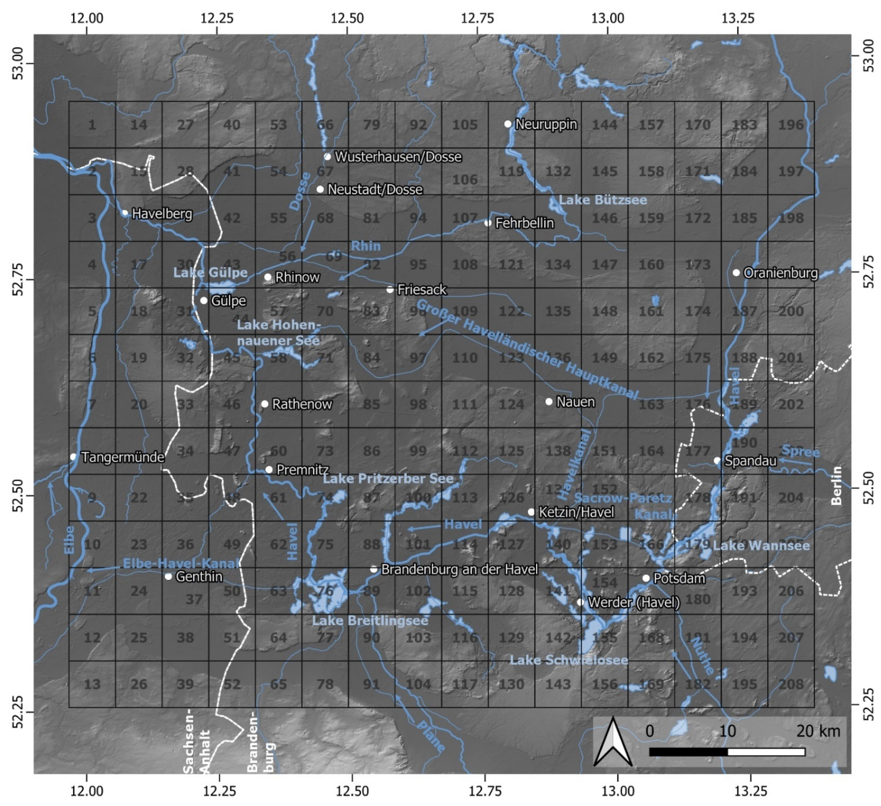
The Havel River has a catchment area of approximately 24,000 km² and a length of 325 km. It is a lowland river with a small difference in altitude between its source (63 m a.s.l.) and mouth (22 m a.s.l.) at the Elbe River. The Havel River flows through numerous lakes and is partially characterized by a multi-channel system [35]. The Lower Havel River Region (Figure 1) represents the western part of the Brandenburg glacial area [36], which consists of gently undulating till plains, sandy valley fills with covering dunes and hilly terminal moraines [37]. The region is characterized by a large proportion of fens. Of particular importance here are the Rhinluch and the Havelländisches Luch (‘Luch’ means swamp or fen) (Figure 1). The large fens lie in former glacial valleys, which were no longer active at the end of the Weichselian glacial period. Afterward, isolated kettle lakes formed, some of which had already silted up by the late-glacial to early Holocene. In the Holocene, large areas of peat began to form on the sandy deposits of the glacial valleys, which ended with fen formation in the late Holocene [38,39,40].
Human settlement in the Lower Havel River Region began in the Final Paleolithic at the latest. The human activities in the subsequent Mesolithic did not result in any lasting changes to the landscape [41,42,43,44,45]. Rather, what changed the landscape were the sea level rises during the Calais transgressions in the Middle Holocene [46,47], which led to the formation of backwater of the Havel and, in turn, to an influx of Elbe water into the Havel lowlands and ultimately to excessive fen formation [38,48]. With the transition to the Neolithic [49] and the subsequent Bronze and Iron Ages, there was initial deforestation and evidence of the first cultivated plants, although the grassland open habitats that are still characteristic today in the Havel floodplain are associated with a natural origin in the early Holocene [50,51]. Slavic population groups began to settle in the area from the 7th century AD onward, but the high groundwater level and frequent flooding in the area of the Havel floodplain and adjacent Rhinluch fen beginning in the Subboreal [40,43] threatened settlements [52]. Slavic fortifications and settlements were concentrated along watercourses and lakes and were therefore particularly exposed to hydrological changes [53,54]. Since the beginning of the high medieval Ostsiedlung (German colonization, c. 1150–1300 AD), the Elbe River and the Lower Havel River Region have seen a radical phase of landscape and cultural change [55]. This includes large-scale clearing, the foundation of villages and towns, the construction of water mill dams at the towns of Rathenow and Brandenburg and the resulting changes in the water balance [56,57,58]. Another important fact concerning the lower Havel River is that all of the shipping traffic during the Middle Ages from the Mark Brandenburg toward the Port of Hamburg passed through this area. The export of grain over the Havel to Hamburg was a major component of the local economy and important for the development of Berlin. In the medieval and modern period, the lower Havel was one of the main routes of traffic in the region [57,59,60,61]. Along the lower Havel River, the largest river and floodplain renaturation project in Central Europe is currently taking place. In an area of around 19,000 ha that extends for 90 km, the river has been given a largely “natural” hydrological regime again. This includes the restoration of floodplains, the establishment of alluvial forests, the removal of bank constructions, the reconnection of oxbow lakes, and adjustments to land use and water management [62,63].
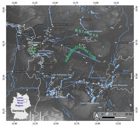
Figure 1.
Study area of the Lower Havel River Region. The blue arrows indicate flow directions, and the yellow dot indicates the position of the Wusterhausen (Dosse) groundwater-level measuring point. The white dots indicate hydro-engineering measures from the 13th to the 21st century (Tables 2–4). The white dots with a “W” indicate land reclamation, drainage works and melioration measures in peatlands and floodplains since the 17th century (Table 5). The yellow rectangles indicate the “Lower Havel Inner Delta” and “Lake Gülpe area” local study sites. Data source of the digital elevation model: [64] and references therein.
2.2. Semi-Quantitative Approach for the Evaluation of Past Hydro-Engineering Measures and Land Reclamation Activities in the Lower Havel River Region
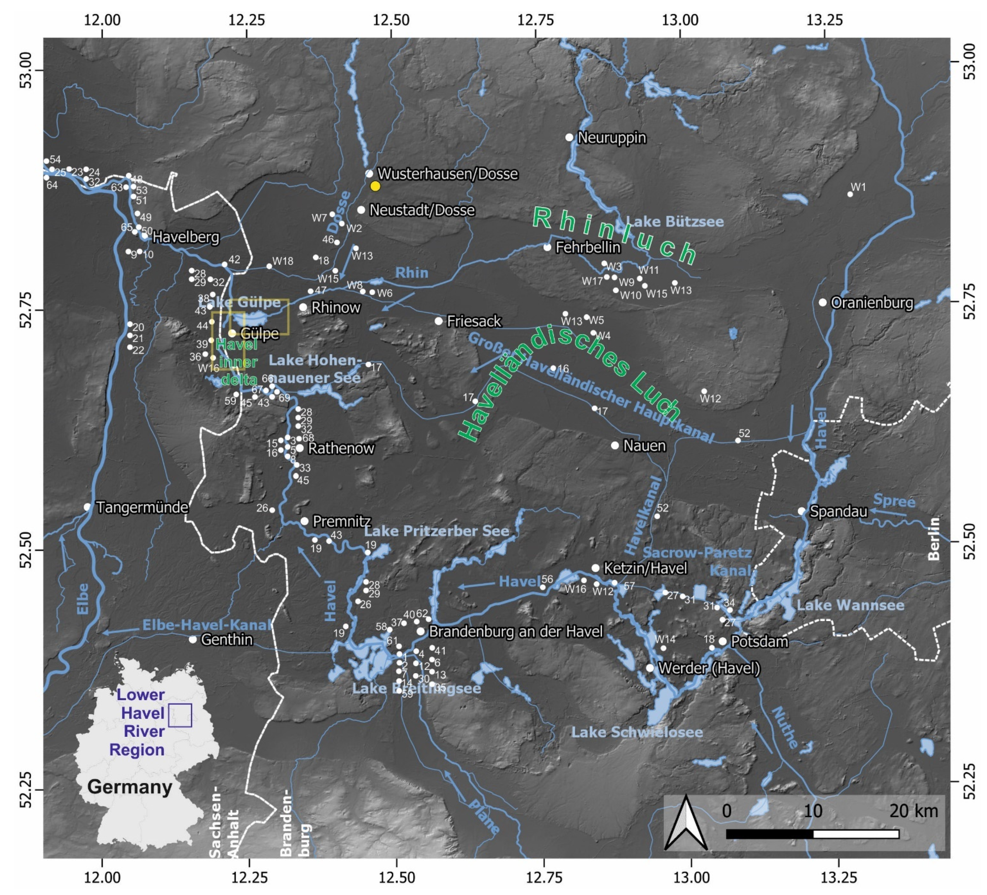
As a first step, selected written sources about past hydro-engineering measures in floodplains and about land reclamation activities in wetlands in the Lower Havel River Region were reviewed. The evidence is documented in Tables 2–5 and includes hydro-engineering measures for inland navigation and hydropower installations (Tables 2–4) as well as land reclamation and drainage work in wetlands (Table 5). In the second step, the human impact in the Lower Havel River Region is evaluated using a semi-quantitative approach. The spatial positions of the punctual, linear and areal hydro-engineering activities are allocated to individual grids of 6 × 6 km2 (Figure 2). This approach results in a spatial and temporal distribution of the individual measures at a grid-scale resolution. Locations from written sources (Tables 2–5) are assigned to 208 squares measuring 6 × km2. Every mention in a written source is considered a hydro-engineering event and recorded with the value n = 1 per associated square. Spatially larger measures are distributed over several squares. In this case, values of n = 1 are taken into account for each affected square. Finally, all recorded hydro-engineering events and land reclamation measures are summed up per square.
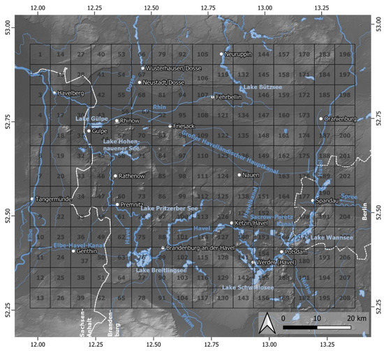
Figure 2.
Structural concept of the semi-quantitative approach used in this study to evaluate evidence of hydro-engineering measures and land reclamation activities from the 13th to 20th centuries. Data source of the digital elevation model: [64] and references therein.
2.3. Local Study Sites for Surface Water Area Reconstructions from Maps
The local study sites the “Lower Havel Inner Delta” and the adjacent “Lake Gülpe” (yellow rectangles in Figure 1) lie in the area of the Lower Havel River Region. The large expanse of the Lower Havel Inner Delta results from the former confluence and the associated large-scale glacio-fluvial erosion processes of the Weichselian Baruth, Berlin and Eberswalde glacial valleys [36,65]. The Lower Havel Inner Delta is characterized by a multi-channel and meandering river system with oxbow lakes and episodic floods, especially during spring [66]. Lake Gülpe, which adjoins the Lower Havel Inner Delta to the east, probably owes its hollow shape to the postglacial dead ice thawing [38]. The lake is traversed by the Rhin River and reaches a maximum depth of approximately 3 m near the outlet [66]. The local study sites are part of one of a few remaining relatively “near-natural” floodplain areas in Central Europe [67] with high biodiversity and the presence of rare plant and animal species [68,69]. Endangered migratory fish species such as asp (Aspius aspius) and zope (Abramis ballerus) spawn in the area [66]. The lake is a bird sanctuary of supra-regional importance and was designated as a nature reserve in 1967 [70]. The Lower Havel Inner Delta and the Lake Gülpe area are home to an impressive number of rare and threatened plant species and vegetation types. The latter include floodplain meadows of the alliances Cnidion dubii and Potentillion anserinae as well as herbaceous pioneer vegetation [50,71,72], which in turn contain populations of river corridor plant species [73,74] and plant species that reach the western border of their European distribution area in this region [75].
2.4. Exploration of Historical and Topographic Maps for the Reconstruction of Surface Water Area Changes during the Last 230 Years
The State Survey and Geobasis Information Brandenburg [76] provides an overview of the easily accessible historic, topographic and digital maps of the Lower Havel River Region. The period from which historical sources are available spans almost the last six centuries (Table 1). An important criterion for the spatiotemporal analysis of historical maps is the possibility of georeferencing as precisely as possible. The map series noted in Table 1 with an asterisk meet this requirement. Some map series obtained as a Web Map Service (WMS) were already georeferenced. In the case of the Prussian original map series, georeferencing could be carried out with sufficient accuracy due to suitable benchmarks (e.g., churches and bridges) and coordinate grids. With the help of Quantum Geographical Information System (QGIS) version 3.22.1, the surface water areas of the map sheets from 1787, 1843, 1880, 1997 and 2020 were digitized and quantified. The oldest map series digitized was the Schmettau map series, which was created under the direction of the Prussian officer and cartographer Friedrich Wilhelm Karl Graf von Schmettau in the years 1767–1787 for the Prussian territory east of the Weser River and in the years 1780–1793 for Mecklenburg. In the context of georeferencing via topographical benchmarks and a subsequent quality check, it was possible to show that the Schmettau maps are surprisingly accurate for their time of origin [77]. For the Prussian territory, 270 sheets with a scale of 1:50,000 were created, which are now in the holdings of the Berlin State Library [78]. The original map sheet from 1843 is available as a georeferenced layer [76,79,80].
The Lower Havel Inner Delta and the Lake Gülpe area (Figure 1) were selected as the local study areas. While the first area represents a river landscape, a stagnant open water body marks the second area. Due to the specific behaviors of each hydro-geomorphic system, the quality of the map sheet series and the methodological approach were checked by analyzing the local areas separately and then comparing the results with one another.
In order to derive lake-level fluctuations from the changing surface water areas, transects (T1–T5) were created at the margins of Lake Gülpe, in which the lake shorelines read from the maps were linked to the heights from the Light Detection and Ranging (LiDAR) digital terrain model [76]. Only the shorelines of the maps from 1843 AD, 1880 AD, 1997 AD and 2020 AD [76] were taken into account, since the Schmettau map series from 1787 AD [76] was found to not have sufficient positional accuracy for the conversion into lake levels.

Table 1.
Overview of historical and modern maps from the Lower Havel River Region. Maps were marked with an asterisk (*) if they were found to be suitable for our reconstruction of past landscape dynamics according to position accuracy. This was also possible with some restrictions for the Schmettau map series. WMS: Web Map Service.
| Map Series | Year | Scale |
|---|---|---|
| Brandenburgensis Marchae Descriptio [76] | 1588 | 1:880,000 |
| Markgrafschaft und Kurfürstentum Brandenburg [76] | 1696 | 1:450,000 |
| Karte des Kurfürstentums Brandenburg [76] | 1750 | 1:550,000 |
| Geographische Karte des Kurfürstentums Brandenburg [76] | 1758 | 1:550,000 |
| Neue geographische Karte der Markschaft Brandenburg [76] | 1773 | 1:625,000 |
| Schmettausches Kartenwerk Brandenburg (Schmettau map series) (*): WMS [76] | 1787 | 1:50,000 |
| Spezialkarte von der Mittelmark [76] | 1790 | 1:300,000 |
| Preußische Urmesstischblätter (Prussian original map series) * [76] | 1843 | 1:25,000 |
| Geologische Karte (GK25) (Geological map series) * [81] | 1880 (1883–1884) | 1:25,000 |
| Deutsches Reich–Messtischblätter (Topographic map series) *: WMS [76] | 1880 (1882) | 1:25,000 |
| Digital topographic map (preliminary edition) *: WMS [76] | 1997 | 1:10,000 |
| Digital topographic map *: WMS [76] | 2020 | 1:10,000 |
| Light Detection and Ranging (LiDAR)-based digital terrain model* [76] | 2020 | 1-m resolution |
3. Results
3.1. Review of the History of Human Impacts on the Region-Scale Water Balance
Written sources contained ample information on the settlement history and water regulation measures in the study region. We found that, in the course of the medieval Ostsiedlung (German colonization, c. 1150–1300 AD), two water mills were built in the cities of Rathenow and Brandenburg at the lower Havel River (Table 2). Since the 13th century AD, the weirs of water mills in combination with fish weirs apparently caused a general increase in river levels of 1–2 m along the Havel River and in adjacent rivers and streams [56,60,82,83]. These processes also led to further expansion of the fens near the Havel riverbank. These same weirs also significantly restricted inland navigation [82]. In the 13th century, the Elbe dike pushed back the floods of the Elbe from the Havel floodplain [38], but at the same time, there was frequent pondage of the Havel River itself, which led to further waterlogging [37]. With regard to the cities’ need for grain, the rights to damming mills had priority over the interests of agriculture for many centuries [59]. Thus, human activities up through the early modern period intensified the natural character of the landscape as a boggy lowland area.
Table 2.
Hydro-engineering projects in the Lower Havel River Region from the 13th to 17th centuries AD. Numbers refer to locations on Figure 1.
The abundance of water, however, was countered with great efforts in the following centuries [8,37]. First, land reclamation measures were undertaken in the 17th century AD [59,85]. Specialists in the construction of dikes, the creation of drainage ditches and the market-oriented introduction of dairy farms came from Holland [59]. In 1718, Prussian King Friedrich Wilhelm I began the reclamation of large fen areas of the Rhinluch and the Havelländisches Luch [86] (Table 5) and the settlement of people (“Peuplierung”) there. The construction of the Havelländische Große Hauptkanal took place between 1718 and 1725 [87] (Table 3 and Figure 1), during which the local population also had to provide auxiliary services [59]. The Königshorst domain became an agricultural model farm that supplied the royal court.
Table 3.
Hydro-engineering projects in the Lower Havel River Region during the 18th and 19th centuries AD. Numbers refer to locations on Figure 1.
Under Frederick the Great (1712–1786) in particular, further groundwater lowering measures were carried out in the Dossebruch (Dosse swamp), such as the construction of drainage ditches and the demolition of water mills on the Rhin River in 1773. In the years 1773–1775, the Friedrichsdorf colony and six other villages were built southwest of Neustadt (Dosse) [37,59] (Table 5). Settlers from the Palatinate and Rhineland were hired to live here [91]. With the drainage of the Rhinluch and Dossebruch, the landscape was intensively reshaped [37]. The conditions in the meliorated wetlands were favorable for cattle farming and the cultivation of rye, potatoes and vegetables. All the new agricultural areas were settled with recruited people. In addition, Poles, Saxons and Mecklenburgers came into the country [91]. In total, around 300,000 colonists had immigrated to Prussia by the time of the death of Frederick the Great in 1786. Around 20,000 colonists were settled in the former Rhin, Dosse and Jäglitz wetlands [91]. The extensive land reclamation of the 18th century AD, however, had only little influence on the still-recurring and widespread flooding in the former wetlands [37].
However, in the upper Rhinluch and the Havelländisches Luch, peat cutting and the lowering of the groundwater level as part of large-scale drainage works to create cropland from the 18th century AD on led to a significant decline in the surface water area of Lake Wublitzsee and Lake Kremmen [92,93]. In 1841, Lake Kremmen had an area of 3.9 km2, but by 1985, it had been reduced to two smaller residual lakes with a total surface water area of 0.8 km2 [93].
Since the mid-1840s, there has been an increase in aquatic plants in the nutrient-rich waters of the Havel, which has had a negative impact on the drainage. Among these plants was the invasive Canadian waterweed (Elodea canadensis), which became a significant problem [59]. Limnological studies also show trends toward increasing eutrophication of Brandenburg and Mecklenburg water bodies beginning in the first half of the 20th century at the latest [94].
The natural flood frequency within the lower Havel and Dosse floodplains was altered to a great extent in the 19th and 20th centuries AD through hydraulic engineering (Table 3 and Table 4). These measures have resulted in the reduction of the area of the land prone to flooding by 90% over the second half of the 20th century [37]. As a result of the hydraulic engineering work on the lower Havel (Gvensdorfer Vorfluter, embankments), the danger of Elbe floods and the Havel backwater decreased significantly from 1950 to 1960 [59,61,95]. Furthermore, the amplitude between the mean low waters and mean high waters was significantly reduced at Brandenburg (Havel) over the course of the second half of the 20th century AD [56].
Table 4.
Hydro-engineering projects in the in the Lower Havel River Region during the 20th century AD. Numbers refer to locations shown in Figure 1.
Particularly from the 1960s until the political turn in 1989, so-called Komplexmeliorationen (hydromeliorations) were carried out in wetlands with great technical effort, with the aim of intensive agricultural use [8,61,98,99,100]. In the upper Rhinluch, these measures led to a significant decrease in the number of drainage trenches. The remaining trenches were dammed in the summer, which overall led to a more balanced groundwater level in the upper Rhinluch. However, it became necessary to supply the area with up to 20 million m3 of additional water from the Mürnitz and the upper Rhin catchment area annually [101].
Table 5.
Land reclamation, drainage works and melioration measures (W = wetland) in the Lower Havel River Region since the 17th century AD. Numbers refer to locations shown in Figure 1.
Table 5.
Land reclamation, drainage works and melioration measures (W = wetland) in the Lower Havel River Region since the 17th century AD. Numbers refer to locations shown in Figure 1.
| No | Land Reclamation, Drainage Works and Melioration Activities | Construction Time |
|---|---|---|
| W1 | Neuholland: foundation of Dutch settlement [59] | 1659 |
| W2 | Dossebruch and Neustädtisches Luch: drainage works [59,86] | 1670–1680 |
| W3 | Rhinluch: drainage measures at Linum (200 ha) [59] | 1705–1710 |
| W4 | Havelländisches Luch: drainage works and foundation of Königshorst, Nordhoff, Lobeofsund, Kienberg, Hertefeld, Kuhhorst, Mangelshorst, Deutschhof, Hertefeld, Sandhorst, Ribbeckshorst, Dreibrück and Rohlandshorst [59,86] | 1718–1724 |
| W5 | Havelländisches Luch: peat cutting at Königshorst [59] | 1746–1750 |
| W6 | Dossebruch (Dreetz): drainage works and foundation of Bartschendorf, Baselitz, Blumenaue, Fischershof, Giesenhorst, Michaelisbruch, Siegrothsbruch, Webersplan, Wilhelminenaue, Wolfsplan and Ziethensau [37,59] | 1747–1778 |
| W7 | Dossebruch (Neustadt): drainage works and foundation of Friedrichsdorf and six other colonist villages [37,59] | 1773–1775 |
| W8 | Dossebruch (Dreetz): demolition of the Dreetz water mill | 1773 |
| W9 | Rhinluch: drainage measures [59] | 1772–1776 |
| W10 | Upper Rhinluch: peat cutting at Fehrbellin and Linum [59] | 1785 until the end of the 19th century |
| W11 | Upper Rhinluch: construction of the Schwarzer Graben for peat cutting [59] | 1797–1798 |
| W12 | Lower Havel floodplain: drainage works [59] | 1777–1783 |
| W13 | Dosseluch, Rhinluch and Havelländisches Luch: foundation of the Luchgraben-Schauverband and cleaning of the existing drainage systems [59] | 1842 |
| W14 | Golmer Bruch: draining of the fen [59] | 1855 |
| W15 | Upper Rhinluch: melioration of former peat cutting areas between Kremmen and Fehrbellin, foundation of Zietenhorst and Linumhorst [59] | 1912–1931 |
| W16 | Lower Havel floodplain: land reclamation by enclosure in the lower Havel floodplain (Komplexmelioration), changes from pastures to arable land [59,61] | 1960–1970 |
| W17 | Upper Rhinluch: melioration (Komplexmelioration) with decrease in fen area (9%) but increase in summer groundwater levels [99,100] | 1974–1976 |
| W18 | Dosse River floodplain: melioration and drainage works (Komplexmelioration) for the intensification of agrarian land use [61] | 1968–1987 |
The intensification of agricultural activities in the 20th century represents a major human intervention in the region. Due to the immense nutrient input from agriculture, Lake Gülpe has changed from eutrophic to polytrophic [66]. With the partial elimination of intensive agrarian land use since the political turn of 1989, extensive nature conservation efforts have come into focus in the region [37]. An outstanding example is the riparian strip project “Lower Havelniederung between Pritzerbe and Gnevsdorf”, a section of which comprises the Lower Havel Inner Delta and Lake Gülpe. The measures have been implemented since 2016 [101]. The aim of the rewilding measures is to allow the Lower Havel Inner Delta to flow through again all year round, to improve the multi-channel system through increased stream velocity and to create more habitats for rare flora and fauna in the form of floodplain forest recreation [97].
3.2. Semi-Quantitaive Approach: Region-Scale Distribution of Hydro-Engineering Activities and Drainage Works
If one considers the spatial distribution of hydro-engineering activities, hydromelioration measures and drainage works (Figure 3), a focus becomes apparent on the early urban settlement centers (Brandenburg, Rathenow), the mouth of the Havel River and on the hydromelioration and drainage work areas in Dosseluch and in particular the upper Rhinluch. In the upper Rhinluch, peat-cutting activities were also important. Basically, it can be seen that the entire area of the Lower Havel River Region has been affected by intensive hydraulic engineering activity over the past few centuries.
Figure 3.
Semi-quantitative spatial representation of hydro-engineering measures from the 13th to 21st centuries in the Lower Havel River Region. The square values indicate the number of pieces of evidence from the reviewed written sources (see Table 2, Table 3, Table 4 and Table 5). Data source of the digital elevation model: [64] and references therein.
3.3. Local-Scale Study Sites: Changes in Surface Water Areas during the Last 230 Years
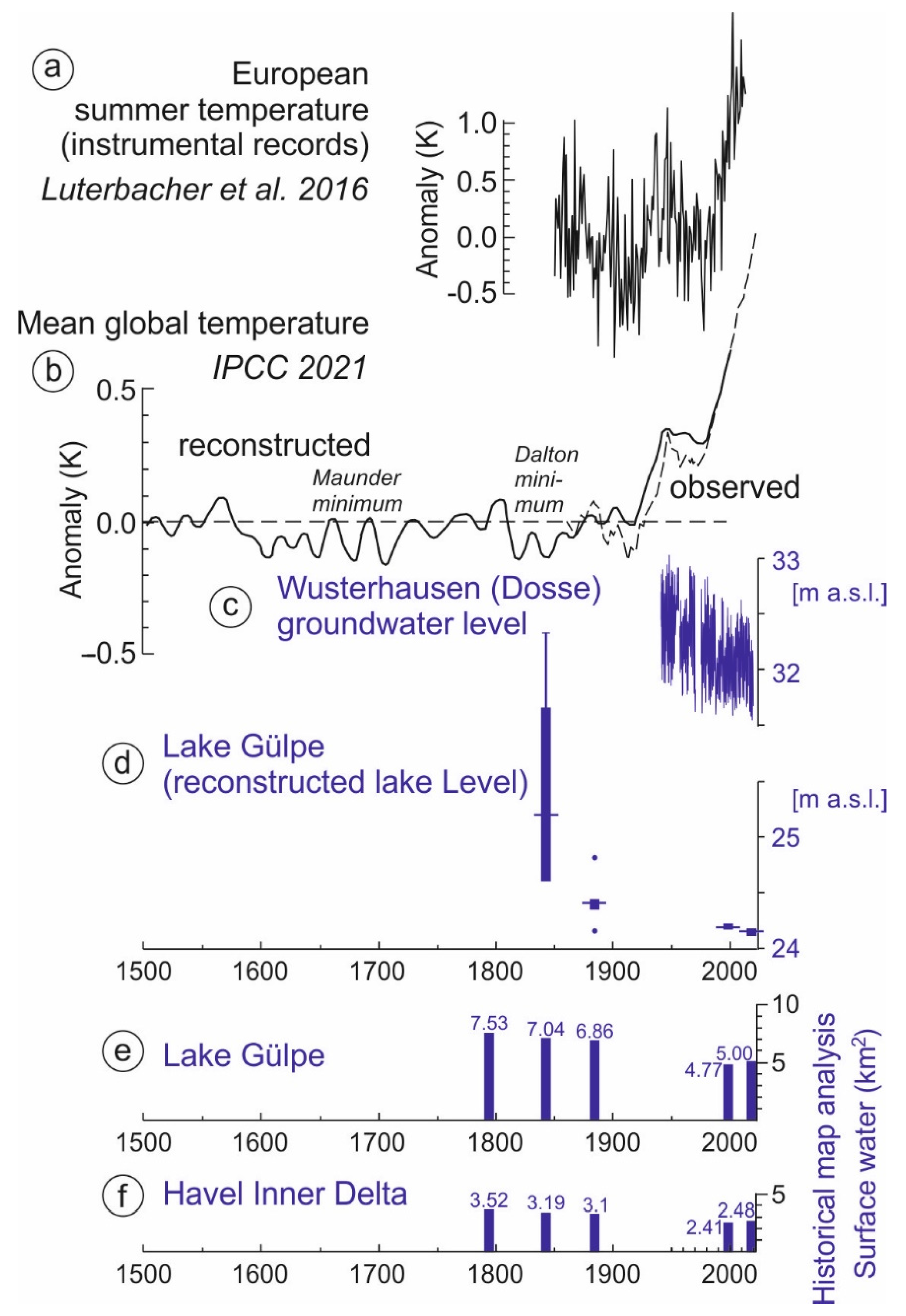
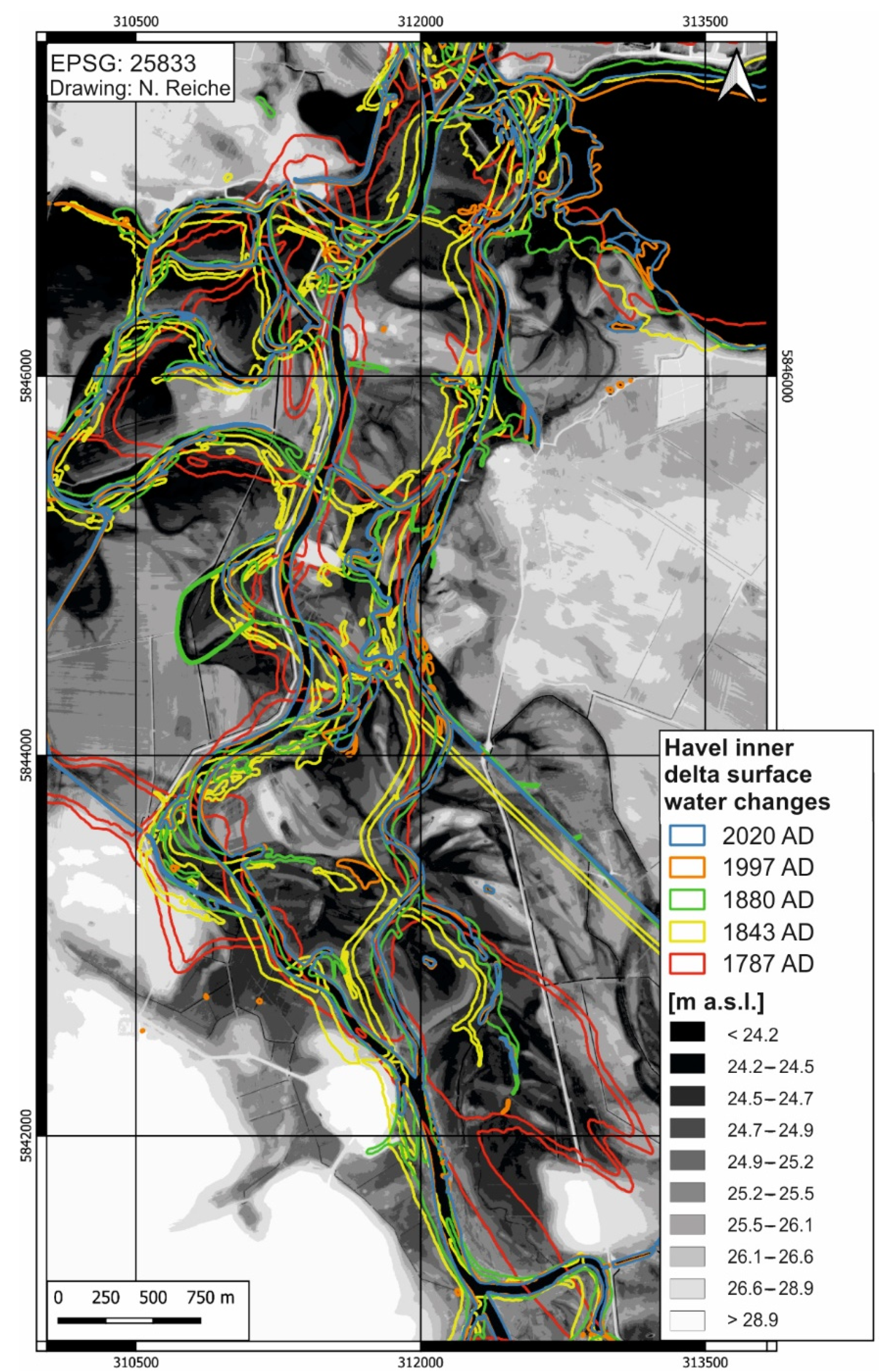
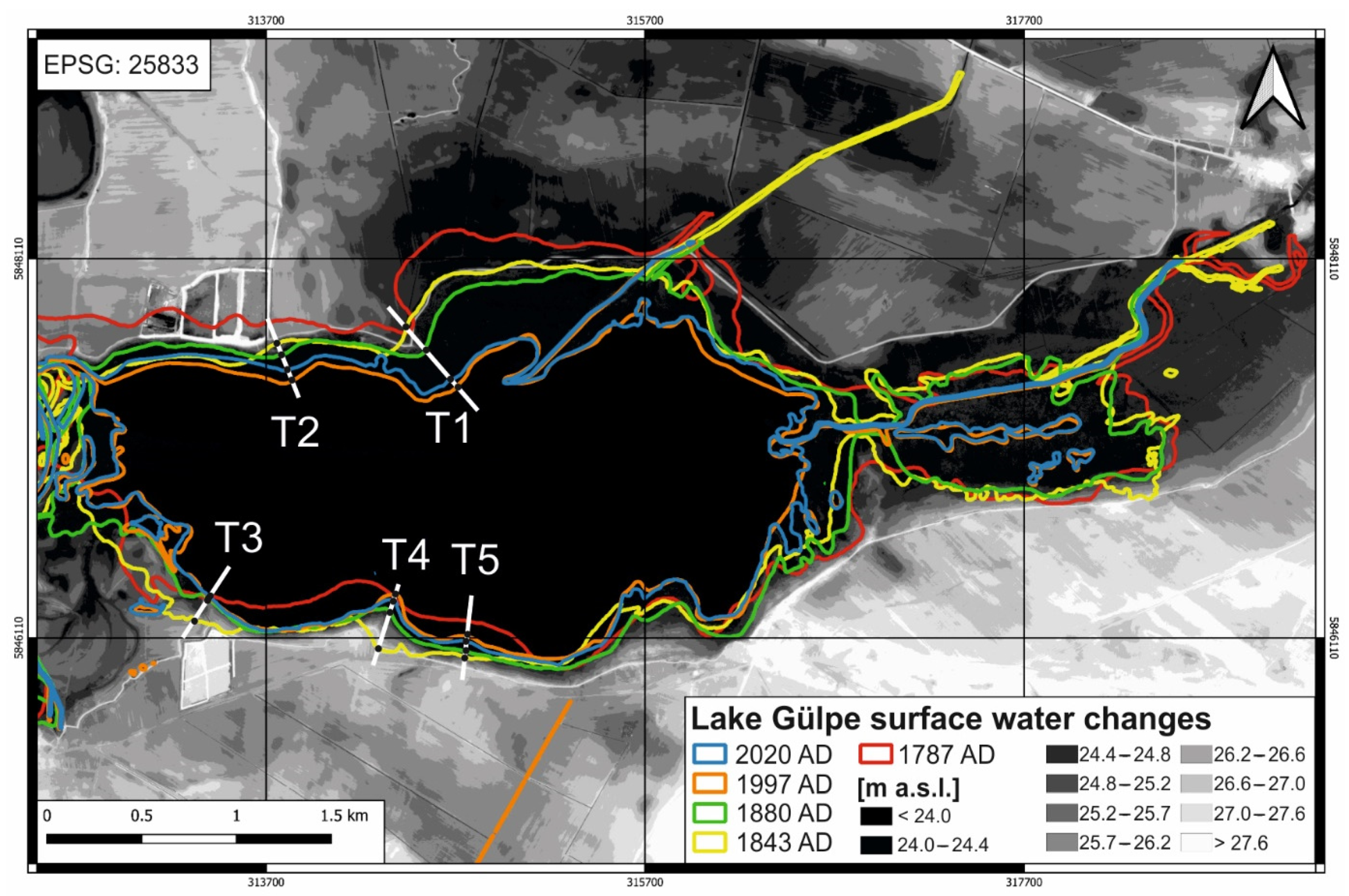
We digitized the surface water areas from five different historic and modern maps for a section of the Lower Havel Inner Delta as well as for Lake Gülpe and then calculated their areas (Figure 4 and Figure 5). From this, it becomes clear to what extent there has been a change in the position and size of the surface water areas in the study area since 1787 AD. Both sub-areas examined showed a declining trend that started in the pre-industrial period. Between 1787 and 1880 AD, the analyzed fluctuations in the size of the surface water areas were between 7.53 and 6.86 km2 in the area of Lake Gülpe (Figure 6e) and between 3.52 and 3.1 km2 in the Lower Havel Inner Delta (Figure 6f). There was a noticeable decline in the size of surface water areas between 1880 AD and 1997 AD from 6.86 to 4.77 km2 at Lake Gülpe and from 3.1 to 2.41 km2 in the Lower Havel Inner Delta. The values from 1997 AD remained roughly constant through 2020 AD. Accordingly, it can be said that the surface water areas have decreased considerably since 1787 AD.
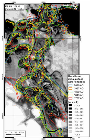
Figure 4.
Changes in Lower Havel Inner Delta surface water areas as a reconstruction from historical [76] and modern maps [76].

Figure 5.
Changes in Lake Gülpe surface water areas as a reconstruction from historical [76] and modern maps [76]. The transects T1–T5 indicate the coupling of shorelines from map records [76] (1843 AD, 1880 AD, 1997 AD and 2020 AD) with LiDAR-based DEM data [76] for the reconstruction of lake level changes.
4. Discussion
4.1. The Historical Map Record Indicates a Decrease in the Surface Water Area
According to the historical map record, the size of the surface water areas decreased by 29.6% within the Lower Havel Inner Delta (Figure 6e) for the entire period from 1787 AD to 2020 AD. In the area of Lake Gülpe, the surface water area decrease was even higher—33.6%—in the same period (Figure 6f). In the two local study areas of the Lower Havel River Region, a decline in surface water area was particularly noticeable for the period from 1880 AD to 1997 AD. The roughly comparable declines for the Lower Havel Inner Delta and Lake Gülpe are striking. They might be attributed on the one hand to the hydrological coupling of both areas and on the other to the reliability of the map series, although we do not have any information about seasonality effects in the course of the topographical surveys. Other historical-geographical studies have pointed out the problem of map generalizations with regard to the determined changes in area sizes [102]. In the present study, however, this was unlikely, since the representation of Lake Gülpe in particular did not require a generalization, and the selected scale was at least 1:50,000 (Table 1) and therefore completely adequate.
The calculated lake level data (Figure 6d) also showed a continuous decline over the period from 1843 AD to 2020 AD. However, the calculated data for 1843 AD should be used with great caution, as the box plot showed a very large scatter. Considerably more reliable data are available for the three more recent calculations. This resulted in a decline in the lake levels of about 20–40 cm from 1880 AD to 1997 AD. These values match with the lake level information on the 1880 AD [76] and 1997 AD [76] maps, showing a decline of exactly 40 cm for this period. However, from here onward, this study relates exclusively to the calculation of the surface water areas, since this is the only way to compare the two sub-study areas “Lower Havel Inner Delta” and “Lake Gülpe”, and these data sets also appear to be robust for the entire period from 1787 AD to 2020 AD.
The data of the surface water area generated from the analysis of the historical maps are particularly valuable, because they significantly extend the length of instrumental data recordings into older times and thus provide potential clues as to which climatic and anthropogenic control variables may be responsible for the long-term water balance in the region. Furthermore, information about long-term changes in the sizes of water surface areas might be relevant for river rewilding programs [103].
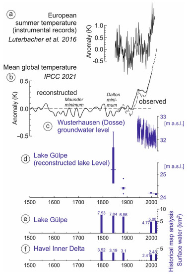
Figure 6.
Climatic and hydrological parameters: (a) instrumental record of European mean summer temperature anomalies relative to the 1961–1990 baseline [104], (b) change in global surface temperature as a decadal average [11], (c) instrumental record of the Wusterhausen (Dosse, Figure 1; lat: 52.883268, long: 12.46536) groundwater level [105], (d) reconstructed lake levels (box plots) from past Lake Gülpe shorelines from historical [76] and modern maps [76] (1843 AD, 1880 AD, 1997 AD and 2020 AD) and coupled LiDAR DEM data (own data analysis on the basis of transects T1–T5 in Figure 5), (e) changes in surface water area at Lake Gülpe as a reconstruction from historical [76] and modern maps [76] (1787 AD, 1843 AD, 1880 AD, 1997 AD, 2020 AD and this study) and (f) changes in surface water area in the Lower Havel Inner Delta as a reconstruction from historical [76] and modern maps [76] (1787 AD, 1843 AD, 1880 AD, 1997 AD, 2020 AD and own data analysis).
4.2. Climatic Effects on the Decline in Surface Water Areas
The low values of the surface water areas in the last few decades correspond to the global temperature record, which has documented higher mean temperatures since at least the 1980s (Figure 6b [11]). This observation is also supported by meteorological data on the regional and local scales. The instrumentally measured mean summer temperatures in Europe have noticeably increased in the same period (Figure 6a [104]), and the mean annual temperatures recorded by the meteorological station in Berlin-Dahlem also show an increase of around 1.0 K since the 1970s [106]. Furthermore, an available instrumental record from a groundwater-level-monitoring well at Wusterhausen (Dosse) (Figure 6c), which is 20 km away from Lake Gülpe, strongly supports the multi-decadal drying phase evidenced by the map data set. Lake level records from the Havel headwaters have exhibited decreasing levels during recent decades as well [107].
A paleohydrological study from the Schorfheide region, which is about 100 km northeast of Lake Gülpe, concluded that lake levels have fallen sharply in the last four decades [9]. The study was based on the comparison of instrumental data and historical sources such as aerial photographs and maps. The authors concluded that the lake level fluctuations in the Schorfheide area have mainly been related to the climate over the past 100 years. However, the authors pointed out that this does not apply to all lakes in the Schorfheide area and that other hydrological factors must be considered at the local level, which can also be tied to human impact (e.g., anthropogenic forest composition and drainage measures). In this context, the present study has to consider the possible human impact on the water balance in the Lower Havel River Region during the last few centuries.
4.3. Semi-Quantitaive Approach: Potential Human Impact on Surface Water Areas
The evaluation of the written sources using our semi-quantitative approach showed two phases of intense activity for the land reclamation, drainage works and melioration measures, with the first in the 18th century AD and the second in the second half of the 20th century AD (Figure 7a). The first phase was characterized by the primary land reclamation with draining activities and the foundation of colonist villages. In the second phase in the 20th century, the focus was on embankment projects as well as weir constructions for groundwater regulation. In the second phase, there was an additional need for water, as it was desired to raise the groundwater level in the fens during the summer months [59,99]. The land reclamation activities of the first phase led to a sharp decline in groundwater levels within the directly affected peatlands [19,92,93,108] but probably had a low impact on the water received by the Lower Havel Inner Delta and Lake Gülpe. Based on the analysis of the historical maps (Figure 7d,e), only a slight decline in the surface water area could be inferred. The situation was different for the melioration measures in the second phase. Both the increased water demand in the peatlands due to the damming of the drainage trenches in summer [99] and the dike construction measures in the lower Havel floodplain [61] might have been associated with the noticeable reduction in the surface water area of the Lower Havel Inner Delta and the Lake Gülpe area (Figure 7d,e).
Enhanced human hydro-engineering measures (Figure 7b) and land reclamation activities (Figure 7a) indicate an increasing human impact on the Lower Havel River Region since the 18th century AD. At a more regional scale, the pollen record from Lake Tiefer See (Klocksin lake chain in northeastern Germany) showed a noticeable increase in land use taxa since the onset of the 19th century [109,110] (Figure 7c). The lake is located in a roughly comparable region approximately 150 km away.
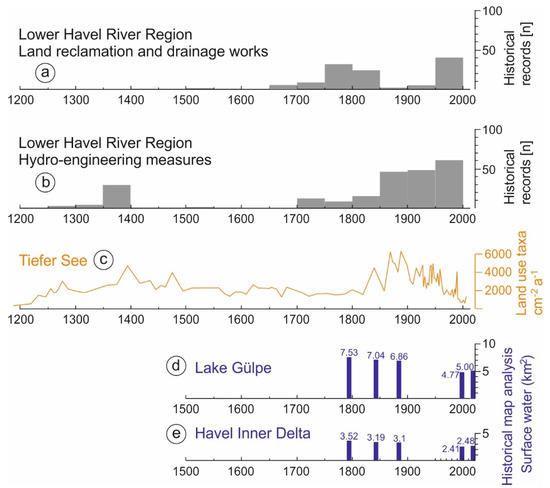
Figure 7.
(a) Land reclamation, drainage works and wetland meliorations at the Lower Havel River Region described in written sources (in this study, number of evidence (n) per 6∗6 km2), (b) hydro-engineering measures in the Lower Havel River Region described in written sources (in this study, number of pieces of evidence (n) per 6∗6 km2), (c) land use taxa (pollen counts) from the Lake Tiefer See pollen record (Figure 1a, Klocksin lake chain in northeastern Germany [109,110]), (d) changes in surface water area at Lake Gülpe as a reconstruction from historical [76] and modern maps [76] (1787 AD, 1843 AD, 1880 AD, 1997 AD, 2020 AD and own data analysis) and (e) changes in surface water area in the Lower Havel Inner Delta as a reconstruction from historical [76] and modern maps [76] (1787 AD, 1843 AD, 1880 AD, 1997 AD, 2020 AD and own data analysis).

4.4. Potential Impacts of the Elbe Channel Incision
In addition to climatic factors and the human impact, hydrological processes must be considered as potentially having contributed to the decline in the surface water areas in the two local study sites of the Lower Havel River Region in recent decades. In the Lower Havel Inner Delta, the decline in the surface water area does not necessarily have to correlate with the water balance, as the runoff also depends on the flow speed and the depth of the channels. In this context, the current deepening of the Elbe riverbed may be an important factor. Gabriel et al. [111] documented that the incision of the Elbe riverbed is a significant process, especially between Mühlberg and the Saale mouth over a distance of c. 180 km. During the last 130 years, the riverbed has been deepened by up to 130 cm, with considerable consequences for the water balance in the Elbe floodplain. However, further downstream in the area of the Havel mouth near Havelberg, the Elbe River is not significantly affected by riverbed deepening [111]. Therefore, Elbe riverbed deepening currently has little hydrological impact on the lower Havel floodplain.
5. Conclusions
We used a multi-proxy approach to quantitatively reconstruct long-term hydrological changes in a hotspot of human impact in Eastern Germany. Our study shows that the multi-temporal reconstruction of the sizes of surface water areas from historical and modern maps is a reliable method of quantitative analysis. Here, quantitative analyses of the surface water areas of the Lower Havel Inner Delta and the adjacent Lake Gülpe area in Brandenburg in northeast Germany were conducted. The GIS analyses for both sites were carried out independently of each other. The Lower Havel Inner Delta and the Lake Gülpe area have seen similar declines in surface water areas during the last two centuries, though the former is a multi-channel river and the latter is a lake. For recent decades, the generated data from the map analyses were compared with the instrumentally measured groundwater levels, and both data sets have shown a desiccation phase over the period under study.
In addition, this study presents a review of written sources that documents the spatial history of hydraulic engineering and land reclamation measures carried out across the Lower Havel River Region over the past 700 years. A grid-related, semi-quantitative approach traced the human impact on the floodplains and wetlands within the Lower Havel River Region. The Late Medieval mill dam constructions in the urban areas of Rathenow and Brandenburg led to large-scale waterlogging at the lower Havel River. With the onset of large-scale drainage works to create cropland, the hydrological conditions changed in the modern period. The semi-quantitative approach revealed that there was an intense human impact during the land reclamation, drainage works and wetland melioration phases in the 18th and 20th centuries AD and during the Lower Havel hydro-engineering measures of the second half of the 19th and the entirety of the 20th century AD. A temporal comparison of the drainage works in the wetlands and the massive hydro-engineering activities in the floodplains with the achieved surface water area reconstructions showed that the surface water areas of the two local study sites were not significantly affected by human activities between 1787 and 1880 AD. However, the surface water areas on the topographic maps from 1997 and 2020 did show a decrease by approximately 30% compared with the areas on the maps from the 18th and 19th centuries AD. This decline can be explained by the additional water demand in the peatlands due to the hydromeliorations, embankment measures in the lower Havel floodplain and the hydraulic engineering-related change in the drainage conditions in the mouth of the Havel in the second half of the 20th century. The influence of the increasingly drier climate over the past few decades must be considered as well.
Author Contributions
Conceptualization, C.Z., H.B. and N.M.; methodology, C.Z., H.B., J.S., N.R., M.T. and N.M.; software, N.R., J.S., H.B. and C.Z.; validation, C.Z., K.K. and J.S.; formal analysis, C.Z., J.S., K.K. and N.R.; investigation, C.Z., J.S., K.K., H.B., N.R., M.T. and N.M.; resources, C.Z., K.K., M.T., H.B., N.R., J.S. and N.M.; data curation, C.Z., J.S., N.R., H.B. and M.T.; writing—original draft preparation, C.Z., N.R., M.T., J.S., K.K. and N.M.; writing—review and editing, C.Z., N.R., M.T., H.B., E.D., M.B., A.L., J.S., K.K. and N.M.; visualization, J.S., N.R. and C.Z.; supervision, C.Z.; project administration, C.Z. All authors have read and agreed to the published version of the manuscript.
Funding
This research received no external funding.
Institutional Review Board Statement
Not applicable.
Informed Consent Statement
Not applicable.
Data Availability Statement
The historic data presented in this study are available in Table 2, Table 3, Table 4 and Table 5. In this manuscript, we document in condensed form (Table 2, Table 3, Table 4 and Table 5) the results of the written source analysis with regard to the hydroengineering measures and land reclamation activities within the Lower Havel River Region. The tables form the basis for the subsequently conducted semi-quantitative approach for the spatiotemporal assessment of past human activities in floodplains and wetlands. We consider this initial semi-quantitative approach to be a helpful tool for developing a better understanding of past human activities on the way to the “Fluvial Anthroposphere” [112].
Acknowledgments
Our sincere thanks go to Matthias Hardt (Leibniz Institute for the History and Culture of Eastern Europe, GWZO, Leipzig) for his very helpful comments on the first draft of this manuscript. We thank two anonymous reviewers and the academic editor for in-depth and valuable recommendations for improving the manuscript during the review process. We acknowledge support from Leipzig University for open access publishing.
Conflicts of Interest
The authors declare no conflict of interest. The funders had no role in the design of the study; in the collection, analyses, or interpretation of data; in the writing of the manuscript; or in the decision to publish the results.
References
- Landgraf, L. Moorschutz in Brandenburg: Beiträge zur Stützung des Landschaftswasserhaushaltes. In Aktuelle Probleme im Wasserhaushalt von Nordostdeutschland: Trends, Ursachen, Lösungen, 1st ed.; Kaiser, K., Libra, J., Merz, B., Bens, O., Hüttl, R.F., Eds.; Scientific Technical Report STR10/10; Deutsches GeoForschungsZentrum: Potsdam, Germany, 2010; pp. 125–128. [Google Scholar] [CrossRef]
- Abatzoglou, J.T.; Dobrowski, S.Z.; Parks, S.A.; Hegewisch, K.C. TerraClimate, a high-resolution global dataset of monthly climate and climatic water balance from 1958–2015. Sci. Data 2018, 5, 170191. [Google Scholar] [CrossRef] [Green Version]
- Heinrich, I.; Balanzategui, D.; Bens, O.; Blasch, G.; Blume, T.; Böttcher, F.; Borg, E.; Brademann, B.; Brauer, A.; Conrad, C.; et al. Interdisciplinary geo-ecological research across time scales in the Northeast German Lowland Observatory (TERENO-NE). Vadose Zone J. 2018, 17, 180116. [Google Scholar] [CrossRef] [Green Version]
- Heinrich, I.; Balanzategui, D.; Bens, O.; Blume, T.; Brauer, A.; Dietze, E.; Gottschalk, P.; Güntner, A.; Harfenmeister, K.; Helle, G.; et al. Regionale Auswirkungen des Globalen Wandels: Der Extremsommer 2018 in Nordostdeutschland. Syst. Erde 2019, 8, 38–47. [Google Scholar] [CrossRef]
- Boergens, E.; Güntner, A.; Dobslaw, H.; Dahle, C. Quantifying the Central European droughts in 2018 and 2019 with GRACE-Follow-On. Geophys. Res. Lett. 2020, 47, e2020GL087285. [Google Scholar] [CrossRef]
- Kaiser, K.; Hattermann, F.F. Auf dem Weg zur Steppe? Der Landschaftswasserhaushalt in Brandenburg im Wandel. Nat. Berl.-Brandenbg. 2021, 35, 4–10. Available online: https://gfzpublic.gfz-potsdam.de/pubman/item/item_5006008_4 (accessed on 17 December 2021).
- Somorowska, U. Amplified signals of soil moisture and evaporative stresses across Poland in the twenty-first century. Sci. Total Environ. 2021, 151465. [Google Scholar] [CrossRef]
- Kaiser, K.; Günther, K.; Lorenz, S.; Merz, B.; Bens, O.; Hüttl, R.F. Historische Veränderungen des Wasserhaushalts und der Wassernutzung in Nordostdeutschland. In Historische Perspektiven auf Wasserhaushalt und Wassernutzung in Mitteleuropa, 1st ed.; Kaiser, K., Merz, B., Bens, O., Hüttl, R.F., Eds.; Waxmann: Münster, Germany, 2012; pp. 73–102. [Google Scholar]
- Kaiser, K.; Heinrich, I.; Heine, I.; Natkhin, M.; Dannowski, R.; Lischeid, G.; Schneider, T.; Henkel, J.; Küster, M.; Heussner, K.U.; et al. Multi-decadal lake-level dynamics in north-eastern Germany as derived by a combination of gauging, proxy-data and modelling. J. Hydrol. 2015, 529, 584–599. [Google Scholar] [CrossRef] [Green Version]
- Dietze, E.; Słowiński, M.; Zawiska, I.; Veh, G.; Brauer, A. Multiple drivers of Holocene lake level changes at a lowland lake in northeastern Germany. Boreas 2016, 45, 828–845. [Google Scholar] [CrossRef] [Green Version]
- IPCC. Summary for Policymakers. In Climate Change 2021: The Physical Science Basis. Contribution of Working Group I to the Sixth Assessment Report of the Intergovernmental Panel on Climate Change; Masson-Delmotte, V., Zhai, P., Pirani, A., Connors, S.L., Péan, C., Berger, S., Caud, N., Chen, Y., Goldfarb, L., Gomis, M.I., et al., Eds.; Cambridge University Press: Cambridge, UK, 2021; in press; Available online: https://www.ipcc.ch/report/ar6/wg1/ (accessed on 17 December 2021).
- Theuerkauf, M.; Blume, T.; Brauer, A.; Dräger, N.; Feldens, P.; Kaiser, K.; Kappler, C.; Kästner, F.; Lorenz, S.; Schmidt, J.P.; et al. Holocene lake-level evolution of Lake Tiefer See, NE Germany, caused by climate and land cover changes. Boreas 2021. [Google Scholar] [CrossRef]
- Germer, S.; Kaiser, K.; Bens, O.; Hüttl, R.F. Water balance changes and responses of ecosystems and society in the Berlin-Brandenburg region—A review. Erde 2011, 142, 65–95. Available online: https://www.die-erde.org/index.php/die-erde/article/view/43 (accessed on 17 December 2021).
- Kaiser, K.; Küster, M.; Fülling, A.; Theuerkauf, M.; Dietze, E.; Graventein, H.; Koch, P.J.; Bens, O.; Brauer, A. Littoral landforms and pedosedimentary sequences indicating late Holocene lake-level changes in northern central Europe—A case study from northeastern Germany. Geomorphology 2014, 216, 58–78. [Google Scholar] [CrossRef] [Green Version]
- Hari, V.; Rakovec, O.; Markonis, Y.; Hanel, M.; Kumar, R. Increased future occurrences of the exceptional 2018–2019 Central European drought under global warming. Sci. Rep. 2020, 10, 12207. [Google Scholar] [CrossRef] [PubMed]
- Blöschl, G.; Kiss, A.; Viglione, A.; Barriendos, M.; Böhm, O.; Brázdil, R.; Coeur, D.; Demarée, G.; Llasat, M.C.; Macdonald, N.; et al. Current European flood-rich period exceptional compared with past 500 years. Nature 2020, 583, 560–566. [Google Scholar] [CrossRef]
- Zlinszky, A.; Timár, G. Historic maps as a data source for socio-hydrology: A case study of the Lake Balaton wetland system, Hungary. Hydrol. Earth Syst. Sci. 2013, 17, 4589–4606. [Google Scholar] [CrossRef] [Green Version]
- Choiński, A. Changes in the area of lakes from the Obra River drainage basin taking place from the beginning of the 19th century. Limnol. Rev. 2009, 9, 159–164. [Google Scholar]
- Barabach, J. The history of Lake Rzecin and its surroundings drawn on maps as a background to palaeoecological reconstruction. Limnol. Rev. 2012, 12, 103–114. [Google Scholar] [CrossRef] [Green Version]
- Piasecki, A.; Skowron, R. Changing the geometry of basins and water resources of Lakes Goplo and Ostrowskie under the influence of anthropopressure. Limnol. Rev. 2014, 14, 33–43. [Google Scholar] [CrossRef] [Green Version]
- Pavelková, R.; Frajer, J.; Havlíček, M.; Netopil, P.; Rozkošný, M.; David, V.; Dzuráková, M.; Šarapatka, B. Historical ponds of the Czech Republic: An example of the interpretation of historic maps. J. Maps 2016, 12 (Suppl. 1), 551–559. [Google Scholar] [CrossRef] [Green Version]
- Kubiak-Wójcicka, K.; Piątkowski, K.; Juśkiewicz, W.W. Lake surface changes of the Osa River catchment, (northern Poland), 1900–2010. J. Maps 2021, 17, 18–29. [Google Scholar] [CrossRef]
- Trachet, J. Mapping/Painting the medieval landscape. A landscape-archaeological analysis of the medieval landscape as depicted by Pieter Porbus. E-Perimetron 2018, 13, 112–120. [Google Scholar]
- Brykała, D.; Podgorski, Z. Evolution of landscapes influenced by watermills, based on examples from northern Poland. Landsc. Urban Plan 2020, 198, 103798. [Google Scholar] [CrossRef]
- Werther, L.; Menn, T.; Schmidt, J.; Müller, H. Modelling pre-modern flow distances of inland waterways—A GIS study in southern Germany. Virtual Archaeol. Rev. 2021, 12, 42–56. [Google Scholar] [CrossRef]
- Hohensinner, S.; Sonnlechner, C.; Schmid, M.; Winiwarter, V. Two steps back, one step forward: Reconstructing the dynamic Danube riverscape under human influence in Vienna. Water Hist. 2013, 5, 121–143. [Google Scholar] [CrossRef] [Green Version]
- Beerten, K.; Leterme, B. Palaeohydrological reconstruction (1500–2000 AD) of a drift sand landscape using pedogeomorphological and historical data (Campine area, NE Belgium). Catena 2015, 135, 208–218. [Google Scholar] [CrossRef]
- Ziliani, L.; Surian, N. Evolutionary trajectory of channel morphology and controlling factors in a large gravel-bed river. Geomorphology 2012, 173–174, 104–117. [Google Scholar] [CrossRef]
- Fernandes, M.R.; Aguiar, F.C.; Martins, M.J.; Rivaes, R.; Ferreira, M.T. Long-term human-generated alterations of Tagus River: Effects of hydrological regulation and land-use changes in distinct river zones. Catena 2020, 188, 104466. [Google Scholar] [CrossRef]
- Le Pichon, C.; Lestel, L.; Courson, E.; Merg, M.L.; Tales, E.; Belliard, J. Historical changes in the ecological connectivity of the Seine River for fish: A focus on physical and chemical barriers since the mid-19th century. Water 2020, 12, 1352. [Google Scholar] [CrossRef]
- Blair, P.; Buytaert, W. Socio-hydrological modelling: A review asking “why, what and how?”. Hydrol. Earth Syst. Sci. 2016, 20, 443–478. [Google Scholar] [CrossRef] [Green Version]
- Pande, S.; Sivapalan, M. Progress in socio-hydrology: A meta-analysis of challenges and opportunities. WIREs Water 2017, 4, e1193. [Google Scholar] [CrossRef] [Green Version]
- Gregory, K.J. The human role in changing river channels. Geomorphology 2006, 79, 172–191. [Google Scholar] [CrossRef]
- Kiss, T.; Fiala, K.; Sipos, G. Alterations of channel parameters in response to river regulation works since 1840 on the Lower Tisza River (Hungary). Geomorphology 2008, 98, 96–110. [Google Scholar] [CrossRef]
- Itzerott, S.; Kaden, K. Die hydrologischen Verhältnisse in der Unteren Havelniederung. In Die ökologische Station Gülpe der Universität Potsdam. Forschungen an der Unteren Havel, 1st ed.; Mühle, R.U., Kaden, K., Jeltsch, F., Eds.; Brandenburgische Umwelt Berichte 13; Potsdam University: Potsdam, Germany, 2003; pp. 27–52. [Google Scholar]
- Kaden, K.; Itzerott, S. Eine landschaftliche Charakteristik der Unteren Havelniederung bei Gülpe. In Die ökologische Station Gülpe der Universität Potsdam. Forschungen an der Unteren Havel, 1st ed.; Mühle, R.U., Kaden, K., Jeltsch, F., Eds.; Brandenburgische Umwelt Berichte 13; Potsdam University: Potsdam, Germany, 2003; pp. 16–26. [Google Scholar]
- Götze, B. Die Untere Havelniederung—Eine gewachsene Kulturlandschaft? Über die Entstehung einer Kulturlandschaft im westlichen Havelland. In Die ökologische Station Gülpe der Universität Potsdam. Forschungen an der Unteren Havel., 1st ed.; Mühle, R.U., Kaden, K., Jeltsch, F., Eds.; Brandenburgische Umwelt Berichte 13; Potsdam University: Potsdam, Germany, 2003; pp. 5–15. [Google Scholar]
- Kaiser, K.; Lorenz, S.; Germer, S.; Juschus, O.; Küster, M.; Libra, J.; Bens, O.; Hüttl, R.F. Late Quaternary evolution of rivers, lakes and peatlands in northeast Germany reflecting past climatic and human impact—An overview. EG Quat. Sci. J. 2012, 61, 103–132. [Google Scholar] [CrossRef] [Green Version]
- Mundel, G. Auensedimentation und Niedermoorbildung in der Unteren Havelaue (Grosse Grabenniederung). Arch. Für Nat. Und Landsch. 1996, 35, 33–59. [Google Scholar]
- Mundel, G. Moorgeologisch-moorbodenkundliche Untersuchungen in Brandenburg. Arch. Agron. Soil Sci. 2002, 48, 7–18. [Google Scholar] [CrossRef]
- Kloss, K. Pollenanalysen zur Vegetationsgeschichte, Moorentwicklung und mesolithisch-neolithischen Besiedlung im Unteren Rhinluch bei Friesack, Bezirk Potsdam. Veröff. Des Mus. Für Ur-Und Frühgesch. Potsdam. 1987, 21, 101–120. [Google Scholar]
- Eickhoff, S.; Gramsch, B. Paläolithikum und Mesolithikum. In Potsdam, Brandenburg und das Havelland; Führer zu den archäologischen Denkmälern Deutschlands 37; Theiss: Stuttgart, Germany, 2000; p. 38. [Google Scholar]
- Gramsch, B. Archäologische Indizien für natürliche und künstliche Wasserspiegelveränderungen in nordostdeutschen Urstromtälern während des Holozäns. In Die Jungquartäre Fluss- und Seegenese in Nordostdeutschland, 1st ed.; Kaiser, K., Ed.; Greifswalder Geographische Arbeiten 26; Greifswald University: Greifswald, Germany, 2002; pp. 189–192. Available online: https://core.ac.uk/download/pdf/71920025.pdf (accessed on 17 December 2021).
- Turner, F.; Tolksdorf, J.F.; Viehberg, F.; Schwalb, A.; Kaiser, K.; Bittmann, F.; von Bramann, U.; Pott, R.; Staesche, U.; Breest, K.; et al. Lateglacial/early Holocene fluvial reactions of the Jeetzel river (Elbe valley, northern Germany) to abrupt climatic and environmental changes. Quat. Sci. Rev. 2013, 60, 91–109. [Google Scholar] [CrossRef]
- Gross, D. Islands in the swamp. Lakescape-reconstructions of Mesolithic sites in the Rhinluch area (Germany). In Human Behavioural Adaptations to Interglacial Lakeshore Environments, 1st ed.; García-Moreno, A., Jarod, M.H., Lutz, K., Geoff, M.S., Elaine, T., Aritza, V., Sabine, G.W., Eds.; Propylaeum-eBOOKS. RGZM Tagungen 37; Römisch-Germanischen Zentralmuseums: Mainz, Germany, 2020; pp. 31–42. Available online: https://books.ub.uni-heidelberg.de/propylaeum/reader/download/647/647-30-88622-1-10-20200414.pdf (accessed on 17 December 2021).
- Behre, K.E. A new Holocene sea-level curve for the southern North Sea. Boreas 2007, 36, 82–102. [Google Scholar] [CrossRef]
- Papenmeier, S.; Hass, H.C. Revisiting the paleo Elbe Valley: Reconstruction of the Holocene, sedimentary development on basis of high-resolution grain size data and shallow seismics. Geosciences 2020, 10, 505. [Google Scholar] [CrossRef]
- Caspers, G. Sedimente und Entwicklung des Elbetales im Gebiet der Wische (Sachsen-Anhalt) seit der Weichsel-Kaltzeit. Untere Havel-Nat. Ber. 2000, 10, 32–42. [Google Scholar]
- Rivollat, M.; Jeong, C.; Schiffels, S.; Küçükkalıpçı, I.; Pemonge, M.H.; Rohrlach, A.B.; Alt, K.W.; Binder, D.; Friederich, S.; Ghesquière, E.; et al. Ancient genome-wide DNA from France highlights the complexity of interactions between Mesolithic hunter-gatherers and Neolithic farmers. Sci. Adv. 2020, 6, eaaz5344. Available online: https://www.science.org/doi/10.1126/sciadv.aaz5344 (accessed on 17 December 2021). [CrossRef]
- Burkart, M.; Küster, H.; Schelski, A.; Pötsch, J.A. A historical and plant sociological appraisal of floodplain meadows in the lower Havel valley, northeast Germany. Phytocoenologia 1998, 28, 85–103. [Google Scholar] [CrossRef]
- Schelski, A. Untersuchungen zur Holozänen Vegetationsgeschichte an der Unteren Havel. Ph.D. Thesis, Potsdam University, Potsdam, Germany, 1997. [Google Scholar]
- Sasse, B. Die spätslawische und frühdeutsche Zeit. In Das Havelland im Mittelalter, Untersuchungen zur Strukturgeschichte Einer Ostelbischen Landschaft in Slawischer und Deutscher Zeit, 1st ed.; Ribbe, W., Ed.; Germania Slavica 5; Duncker & Humbolt: Berlin, Germany, 1987. [Google Scholar]
- Kersting, T. Slawen in Brandenburg: Eine archäologische Momentaufnahme. In Wie die Mark entstand. Jahre Mark Brandenburg, 1st ed.; Müller, J., Neitmann, K., Schopper, F., Eds.; Forsch. Arch. Land Brandenburg 11; Brandenburgisches Landesamt für Denkmalpflege: Wünsdorf, Germany, 2009; pp. 15–30. [Google Scholar]
- Bünnig, W. Der “Pilatsch” bei Gülpe. In Potsdam, Brandenburg und das Havelland; Führer zu den archäologischen Denkmälern Deutschlands 37; Theiss: Stuttgart, Germany, 2000; p. 209. [Google Scholar]
- Schneeweiss, J.; Schatz, T. The impact of landscape change on the significance of political centres along the lower Elbe River in the 10th century A.D. Quat. Int. 2014, 324, 20–33. [Google Scholar] [CrossRef]
- Kaiser, K.; Keller, N.; Brande, A.; Dalitz, S.; Hensel, N.; Heußner, K.U.; Kappler, C.; Michas, U.; Müller, J.; Schwalbe, G.; et al. A large-scale medieval dam-lake cascade in central Europe: Water level dynamics of the Havel River, Berlin–Brandenburg region, Germany. Geoarchaeology 2018, 33, 237–259. [Google Scholar] [CrossRef]
- Bütow, S. Straßen im Fluss. Schifffahrt, Flussnutzung und der Lange Wandel der Verkehrsinfrastruktur in der Mark Brandenburg und der Niederlausitz vom 13. bis zum 16. Jahrhundert; Studien zur brandenburgischen und vergleichenden Landesgeschichte 18; Lukas: Berlin, Germany, 2015. [Google Scholar]
- Müller, J. Wasserbau als Infrastruktur der mittelalterlichen Planstadt—Brandenburg an der Havel. Mitt. Der Dtsch. Ges. Für Archäologie Des Mittelalt. Und Der Neuzeit 2009, 21, 101–114. Available online: https://journals.ub.uni-heidelberg.de/index.php/mitt-dgamn/article/download/17296/11110 (accessed on 17 December 2021).
- Gudermann, R. Morastwelt und Paradies: Ökonomie und Ökologie in der Landwirtschaft am Beispiel der Meliorationen in Westfalen und Brandenburg (1830–1880); Schöningh: Paderborn, Germany, 2000. [Google Scholar]
- Schich, W. Die Havel als Wasserstraße im Mittelalter. Brücken, Dämme, Mühlen, Flutrinnen; Jahrbuch für brandenburgische Landesgeschichte 45: Berlin, Germany, 1994; pp. 31–55. [Google Scholar]
- Uhlemann, H.J. Berlin und die Märkischen Wasserstraßen, 1st ed.; Transpress VEB Verlag für Verkehrswesen: Berlin, Germany, 1987. [Google Scholar]
- Buchta, R. Entwicklung eines Ziel- und Bewertungssystems zur Schaffung nachhaltiger naturnaher Strukturen in großen sandgeprägten Flüssen des norddeutschen Tieflandes, 1st ed.; Mitteilungen des Instituts für Wasser- und Umweltsystemmodellierung der Universität Stuttgart 269; Stuttgart University: Stuttgart, Germany, 2019; Available online: https://elib.uni-stuttgart.de/handle/11682/10537 (accessed on 17 December 2021).
- NABU—Naturschutzbund Deutschland. Ein Blaues Band aus Flüssen und Auen. Neue Fördermöglichkeiten für Renaturierungsprojekte, 1st ed.; NABU: Berlin, Germany, 2019. [Google Scholar]
- Sonny. Digitales LiDAR Geländemodell von Deutschland 20m, Version 1, CC BY 4.0. Available online: https://data.opendataportal.at/dataset/dtm-germany (accessed on 1 December 2021).
- Weiße, R. Beiträge zur weichselkaltzeitlichen Morphogenese des Elbhavelwinkels (mit Hinweisen zur Havel- und Elbentwicklung), 1st ed.; Brandenburgische Umwelt-Berichte 14; Zentrum für Umweltwissenschaften der Universität Potsdam: Potsdam, Germany, 2003; Available online: https://nbn-resolving.org/urn:nbn:de:kobv:517-opus-5958 (accessed on 17 December 2021).
- Petrick, G. Zur Fischfauna des Gülper Sees und der Unteren Havelniederung. Nat. Und Landsch. Brandenbg. 1995, 4, 31–34. Available online: https://lfu.brandenburg.de/sixcms/media.php/9/Heft%20N%26L_4_1994.pdf#page=31 (accessed on 17 December 2021).
- Haase, P. Die Entwicklung der Landnutzung an der Unteren Havel. Nat. Und Landsch. Brandenbg. 1995, 4, 4–11. Available online: https://lfu.brandenburg.de/sixcms/media.php/9/Heft%20N%26L_4_1994.pdf#page=4 (accessed on 17 December 2021).
- Burkart, M.; Wattenbach, M.; Wichmann, M.; Pötsch, J. Die Vegetation der unteren Havelaue: Stand der Forschung und Perspektiven. In Die ökologische Station Gülpe der Universität Potsdam. Forschungen an der Unteren Havel, 1st ed.; Mühle, R.U., Kaden, K., Jeltsch, F., Eds.; Brandenburgische Umwelt Berichte 13; Potsdam University: Potsdam, Germany, 2003; pp. 53–71. [Google Scholar]
- Mühle, R.U. Tierleben—ein zoologischer Überblick zur Unteren Havelniederung. In Die ökologische Station Gülpe der Universität Potsdam. Forschungen an der Unteren Havel, 1st ed.; Mühle, R.U., Kaden, K., Jeltsch, F., Eds.; Brandenburgische Umwelt Berichte 13; Potsdam University: Potsdam, Germany, 2003; pp. 82–97. [Google Scholar]
- Wallschläger, D. Gülper See und Untere Havelniederung aus ornithologischer Sicht—Forschungen an der Ökologischen Station der Universität Potsdam. In Die ökologische Station Gülpe der Universität Potsdam. Forschungen an der Unteren Havel, 1st ed.; Mühle, R.U., Kaden, K., Jeltsch, F., Eds.; Brandenburgische Umwelt Berichte 13; Potsdam University: Potsdam, Germany, 2003; pp. 98–101. [Google Scholar]
- Burkart, M.; Prasse, R. Zur Pflanzlichen Besiedlung Wechselnasser Pionierstandorte im Elb-Havel-Winkel. Untere Havel Naturk. Ber. 1996, 5, 38–50. Available online: https://unterehavel.com/hefte/heft-5/ (accessed on 17 December 2021).
- Wichmann, M.; Burkart, M. Die Vegetationszonierung des Grünlandes am Südufer des Gülper See. Verh. Bot. Ver. Berl. Brandenbg. 2000, 133, 145–175. [Google Scholar]
- Burkart, M. River corridor plants (Stromtalpflanzen) in Central European lowland: A review of a poorly understood plant distribution pattern. Glob. Ecol. Biogeogr. 2001, 10, 449–468. [Google Scholar] [CrossRef]
- Fischer, M.; Burkart, M.; Pasqualetto, V.; van Kleunen, M. Experiment meets biogeography: Plants of river corridor distribution are not more stress tolerant but benefit less from more benign conditions elsewhere. J. Plant Ecol. 2010, 3, 149–155. [Google Scholar] [CrossRef] [Green Version]
- Burkart, M.; Alsleben, K.; Lachmuth, S.; Schumacher, J.; Hofmann, R.; Jeltsch, F.; Schurr, F.M. Recruitment requirements of the rare and threatened Juncus atratus. Flora 2010, 205, 583–589. [Google Scholar] [CrossRef]
- State Survey and Geobasis Information Brandenburg. Geoportal Brandenburg. Available online: https://geobasis-bb.de/lgb/de/geodaten/portale-anwendungen/geoportal-brandenburg/# (accessed on 22 September 2021).
- Kreßner, L. Digitale Analyse der Genauigkeit Sowie der Erfassungs- und Darstellungsqualität von Altkarten aus Mecklenburg Vorpommern—Dargestellt an den Kartenwerken von Wiebeking (ca. 1786) und Schmettau (ca. 1788); Universität Rostock: Rostock, Germany, 2009. [Google Scholar] [CrossRef]
- Crom, W. Das Schmettausche Kartenwerk in der Staatsbibliothek zu Berlin. Vermess. Brandenbg. 2013, 1, 52–53. [Google Scholar]
- Albrecht, O. Beiträge zum militärischen Vermessungs- und Kartenwesen und zur Militärgeographie in Preußen (1803–1921). Schr. Geoinf. Der Bundeswehr 2004, 1, 1–200. [Google Scholar]
- Kugge, C. Die Vermesser am Fluss: Was Historische und Aktuelle Vermessung und Kartographie zum Biosphärenreservat Flusslandschaft Elbe-Brandenburg Erzählen, 1st ed.; Landesvermessung und Geobasisinformation Brandenburg (LGB): Potsdam, Germany, 2009.
- Königlich Preussisches Ministerium für Handel, Gewerbe und öffentliche Arbeiten. Geologische Spezialkarte von Preussen und den Thüringischen Staaten. Sheets Strodehne and Schollene 1:25.000; Königlich Preussisches Ministerium für Handel, Gewerbe und öffentliche Arbeiten: Berlin, Germany, 1883–1884. [Google Scholar]
- Driescher, E. Veränderungen an Gewässern Brandenburgs in Historischer Zeit; Studien und Tagungsberichte 47; Potsdam Landesumweltamt: Potsdam, Germany, 2003. [Google Scholar]
- Dalitz, S. Die Brandenburg in der Havel—Arbeitsstand zu Topografie und Entwicklung der Insel und der Burg. In Wie die Mark entstand. 850 Jahre Mark Brandenburg (Forschungen zur Archäologie im Land Brandenburg 11), 1st ed.; Müller, J., Neitmann, K., Schopper, F., Eds.; Brandenburgisches Landesamt für Denkmalpflege und Archäologisches Landesmuseum: Wünsdorf, Germany, 2009; pp. 54–78. [Google Scholar]
- Riedel, A.F. Die Mark Brandenburg im Jahre 1250, 1st ed.; Ferdinand Dümmler: Berlin, Germany, 1831; Volume 1. [Google Scholar]
- Fontane, T. Havelland. Die Landschaft um Spandau, Potsdam, Brandenburg; Paul Franke: Berlin, Germany, 1930. [Google Scholar]
- Berghaus, H. Landbuch der Mark Brandenburg; Adolph Müller: Brandenburg, Germany, 1854; Volumes 1–3. [Google Scholar]
- Eisentraut, E. Die Melioration des Havelländischen Luchs. In Schauplätze und Themen der Umweltgeschichte: Umwelthistorische Miszellen aus dem Graduiertenkolleg. Werkstattbericht, 1st ed.; Universitätsverlag Göttingen: Göttingen, Germany, 2010; pp. 29–40. Available online: http://library.oapen.org/handle/20.500.12657/32511 (accessed on 17 December 2021).
- Bestehorn, F. Die geschichtliche Entwicklung des märkischen Fischereiwesens. Ph.D. Thesis, Philipps-University, Marburg, Germany, 1913. [Google Scholar]
- Scholz, P.; Teubert, O. Beiträge zur Gewässerkunde der Märkischen Wasserstraßen, 1st ed.; Ernst: Berlin, Germany, 1905. [Google Scholar]
- Ostmann, P. Die Havelregulierungsbauten bei Brandenburg. Z. Für Bauwes. 1915, 65, 251–280. [Google Scholar]
- Kolonistenhof Großderschau. Die Kolonisierung um Großderschau. Available online: http://www.grossderschau.de/seite/38784/die-kolonisierung.html (accessed on 7 October 2021).
- Casperson, G. Der Wublitz-See. Geschichte und Vegetation eines verschwundenen Sees. Märkische Heim. 1957, 2, 90–96. [Google Scholar]
- Krausch, H.D. Zur Landschaftsgeschichte und Vegetation des Kremmener Sees. Nat. Berl. Und Brandenbg. 1985, 21, 56–63. [Google Scholar]
- Nwosu, E.C.; Brauer, A.; Kaiser, J.; Horn, F.; Wagner, D.; Liebner, S. Evaluating sedimentary DNA for tracing changes in cyanobacteria dynamics from sediments spanning the last 350 years of Lake Tiefer See, NE Germany. J. Paleolimnol. 2021, 66, 279–296. [Google Scholar] [CrossRef]
- Gromeyer, E. Physisch-Geographischer Charakter und Landeskulturelle Entwicklung der Havelniederungen Unterhalb Rathenow. Ph.D. Thesis, Pädagogische Hochschule Potsdam, Potsdam, Germany, 1958. [Google Scholar]
- Wasserstraßen- und Schifffahrtsverwaltung des Bundes. Untere Havel Wasserstraße. Available online: https://www.wsa-spree-havel.wsv.de/Webs/WSA/Spree-Havel/DE/01_Wasserstrassen/02_Bundeswasserstrassen/61_Untere_Havel_Wasserstrasse/uhw_node.html;jsessionid=D0F22F49F5A96DD79C526E571590AFFE.live11293#doc2526318bodyText3 (accessed on 2 December 2021).
- NABU—Naturschutzbund Deutschland e.V. Aufwertung der Gülper Havel; NABU: Berlin, Germany, 2015; Available online: https://www.nabu.de/imperia/md/content/nabude/lebendigefluesse/havel/10-nabu-havel-massnahmenblatt_mk3_nd-guelper-havel.pdf (accessed on 17 December 2021).
- Succow, M. Zusammenfassende Beurteilung der Folgen tiefgreifender agrarischer Nutzungsintensivierung der letzten Jahrzehnte auf die Niedermoorstandorte Nordostdeutschlands. In Landschaftsökologische Moorkunde, 1st ed.; Succow, M., Joosten, H., Eds.; Schweizerbart: Stuttgart, Germany, 2001; pp. 463–470. [Google Scholar]
- Zeitz, J. Zur anthropogenen Veränderung der Moore—Oberes Rhinluch. In Landschaftsökologische Moorkunde, 1st ed.; Succow, M., Joosten, H., Eds.; Schweizerbart: Stuttgart, Germany, 2001; pp. 420–430. [Google Scholar]
- Sauerbrey, R.; Lehrkamp, H.; Holz, C. Zum Wandel der Bodenformen in den Niedermoorgebieten Brandenburgs durch langjährige Nutzung. TELMA 2002, 32, 199–206. [Google Scholar]
- NABU—Naturschutzbund Deutschland e.V. Gewässerrandstreifenprojekt Untere Havelniederung zwischen Pritzerbe und Gnevsdorf in den Ländern Sachsen-Anhalt und Brandenburg. Jahresbericht 2019; NABU: Berlin, Germany, 2020; Available online: https://www.nabu.de/imperia/md/content/nabude/lebendigefluesse/havel/jahresbericht_2019.pdf (accessed on 17 December 2021).
- Schielein, P. Neuzeitliche Flusslaufverlagerungen des Lechs und der Donau im Lechmündungsgebiet—qualitative und quantitative Analysen historischer Karten. In Studien zur quartären Talgeschichte von Donau und Lech, Teil II (Bamberger physisch-geographische Studien 2002–2008), 1st ed.; Schellmann, G., Ed.; Institut für Geographie an der Universität Bamberg: Bamberg, Germany, 2010; pp. 215–241. Available online: https://www.uni-bamberg.de/fileadmin/uni/fakultaeten/ggeo_lehrstuehle/geographie_2/Publikationen/BaGeogrSchri24_Schielein2010.pdf (accessed on 17 December 2021).
- Schoor, M.M.; Wolfert, H.P.; Maas, G.J.; Middelkoop, H.; Lambeek, J.J.P. Potential for floodplain rehabilitation based on historical maps and present-day processes along the River Rhine, The Netherlands. Geol. Soc. Spec. Publ. 1999, 163, 123–137. [Google Scholar] [CrossRef]
- Luterbacher, J.; Werner, J.P.; Smerdon, J.E.; Fernández-Donado, L.; González-Rouco, F.J.; Barriopedro, D.; Ljungqvist, F.C.; Büntgen, U.; Zorita, E.; Wagner, S.; et al. European summer temperatures since Roman times. Environ. Res. Lett. 2016, 11, 024001. [Google Scholar] [CrossRef] [Green Version]
- Landesamt für Umwelt Brandenburg. Grundwasserstände. Available online: https://lfu.brandenburg.de/lfu/de/aufgaben/wasser/grundwasser/grundwasserstaende/ (accessed on 1 December 2021).
- Cubasch, U.; Kadow, C. Global climate change and aspects of regional climate change in the Berlin-Brandenburg region. Erde 2011, 142, 3–20. [Google Scholar]
- Küster, M.; Kaiser, K. Historische und aktuelle Gewässerentwicklung im Havel-Quellgebiet (Mecklenburg-Vorpommern). In Aktuelle Probleme im Wasserhaushalt von Nordostdeutschland: Trends, Ursachen, Lösungen, 1st ed.; Kaiser, K., Libra, J., Merz, B., Bens, O., Hüttl, R.F., Eds.; Scientifc Technical Report STR10/10; Deutsches GeoForschungsZentrum: Potsdam, Germany, 2010; pp. 125–128. [Google Scholar] [CrossRef]
- Lehrkamp, H. Durch landwirtschaftliche Nutzung verursachte Veränderungen im Niedermoor, dargestellt am Beispiel des Randow-Welse-Bruches. Wiss. Z. Der Humboldt-Univ. Berl. Agrarwiss. Reihe 1989, 38, 12–15. [Google Scholar]
- Dräger, N.; Theuerkauf, M.; Szeroczyńska, K.; Wulf, S.; Tjallingii, R.; Plessen, B.; Kienel, U.; Brauer, A. Varve microfacies and varve preservation record of climate change and human impact for the last 6000 years at Lake Tiefer See (NE Germany). Holocene 2016, 27, 450–464. [Google Scholar] [CrossRef]
- Nantke, C.K.; Brauer, A.; Frings, P.J.; Czymzik, M.; Hübener, T.; Stadmark, J.; Dellwig, O.; Roeser, P.; Conley, D.J. Human influence on the continental Si budget during the last 4300 years: δ30Sidiatom in varved lake sediments (Tiefer See, NE Germany). Quat. Sci. Rev. 2021, 258, 106869. [Google Scholar] [CrossRef]
- Gabriel, T.; Kühne, E.; Faulhaber, P.; Promny, M.; Horchler, P. Sohlenstabilisierung und Erosionseindämmung am Beispiel der Elbe. Wasserwirtschaft 2011, 6, 27–32. [Google Scholar] [CrossRef]
- Werther, L.; Mehler, N.; Schenk, G.J.; Zielhofer, C. On the way to the Fluvial Anthroposphere—Current limitations and perspectives of multidisciplinary research. Water 2021, 13, 2188. [Google Scholar] [CrossRef]

Publisher’s Note: MDPI stays neutral with regard to jurisdictional claims in published maps and institutional affiliations. |
© 2022 by the authors. Licensee MDPI, Basel, Switzerland. This article is an open access article distributed under the terms and conditions of the Creative Commons Attribution (CC BY) license (https://creativecommons.org/licenses/by/4.0/).