Abstract
The ‘Dynamic System Approach for Geofluids and their Resources’ was developed to harmonize research and the sustainable exploration of geofluids (e.g., groundwater, geothermal and hydrothermal fluids) and the related geo-resources (groundwater, geothermal energy and hydrothermal minerals). The conception is based on the basin-scale groundwater flow systems, which behave as a geologic agent, mobilize, transport and deposit matter and heat, whilst it can be evaluated quantitatively and in a distributed manner. Evaluation of these systems combined, for instance, with numerical, stochastic and isotope methods can jointly manage all types of geofluids, the related resources and the environmental consequences of their exploration and utilization. This paper describes the fundamental concepts of the approach and displays the proposed workflow and guidelines for practical applications such as groundwater vulnerability assessment, managed aquifer recharge, geothermal energy utilization, and the evaluation of hydrothermal mineral potential.
1. Introduction
In recent decades, geologists have recognized that fluids play an essential role in nearly all geologic processes and are ubiquitous in the continental crust to depths of at least 10 to 15 km [1,2]. This led to the birth of a new dynamic paradigm (i.e., system approach) of fluids. Consequently, the continental crust has started to be viewed as a “two-component system: a solid framework that evolves through interactions with geologic fluids” [1]. In the upper continental crust (10–20 km depth), the permeability of rocks may be sufficient to keep up continuous flow systems for 1–10 million years. As a consequence, geofluids have an outstanding effect on every geological process, such as mobilization, transportation, and accumulation of matter and heat [3]. Therefore, knowledge of dynamic fluid systems and fluid-rock interactions in a given tectonic setting basically determines the formation, exploration and exploitation possibilities of geological resources such as groundwater, geothermal energy and hydrothermal mineral deposits. The novel ’Dynamic System Approach for Geofluids and their Resources’ (DSA-GR) was developed according to the goals of the ENeRAG (Excellency Network Building for Comprehensive Research and Assessment of Geofluids) project (European Union’s Horizon 2020 research and innovation program, Grant Agreement No. 810980). It introduces an approach and methodology which can combine all geofluids in a uniform framework.
The current European and national legislative approaches do not provide a common framework for exploring and managing geofluids together, which can lead to neglecting inter-relationships, misinterpreting processes, false prognoses, suboptimal use of natural resources, or negative environmental impacts. Accordingly, the ‘Dynamic System Approach for Geofluids and their Resources’ (DSA-GR) intends to fill in this gap and harmonize the research and sustainable exploration of different forms of geofluids (e.g., groundwater, geothermal and hydrothermal fluids) and the related geo-resources (groundwater, geothermal energy and hydrothermal minerals). Consequently, harmonized geofluid research and utilization is crucial to achieve the Sustainable Development Goals (SDGs) of the United Nations by 2030 (e.g., zero-hunger, good health, clean water and energy, sustainable cities, climate action, life below water and on land) and the related aims of the European Green Deal by 2050 (e.g., zero carbon emissions, circular economy). Accordingly, the highlighted topics of the ENeRAG project such as ‘geofluids and their resources’ were the following: (i) the evaluation of groundwater vulnerability and Managed Aquifer Recharge (MAR) systems for ‘clean water’, (ii) geothermal energy utilization for ‘clean energy’, (iii) mineral potential for ‘critical raw materials’.
The goals of this paper are the followings: (i) display the key concepts of the DSA-GR, which is based on the basin-scale groundwater flow system concept; (ii) propose a workflow for the application of DSA-GR in practice; and (iii) summarize advanced methodological guidelines for the integration of numerical, stochastic and isotope methods into the DSA-GR.
2. Review and Discussion of the Key Concepts
2.1. Basin-Scale Groundwater Flow Systems and Related Resources
The term geofluid implies all fluids below the land surface such as groundwater, geothermal fluids, magmatic fluids, hydrothermal fluids, basin fluids, metamorphic fluids, hydrocarbons, contaminants, etc. Subdisciplines of the different fluids and their resources have evolved separately. The more necessary interdisciplinary approach of geofluids requires a common base, which can be supplied by groundwater interacting with all other fluids during its movement. Accordingly, the base and framework of the DSA-GR are provided by the basin-scale groundwater flow systems.
According to the fundamental concept of the so-called basin-scale hydrogeology there are no aquicludes or impermeable rocks that completely impede groundwater flow [4,5,6,7,8]. Every kind of rock has some permeability—the lower permeability rocks (i.e., aquitards or seals) contain and transmit less fluid than higher permeability rocks (i.e., aquifers or reservoirs). As a result, regional hydraulic continuity is a phenomenological property of the rock framework, whilst its observability depends on the spatial and time scale of the monitoring [9,10].
Due to the regional hydraulic continuity, basin-scale groundwater flow systems can evolve [11,12,13] which is mainly a matter of the hydraulic connection between the aquifer systems rather than a matter of rock types (e.g., siliciclastic or carbonate) [14].
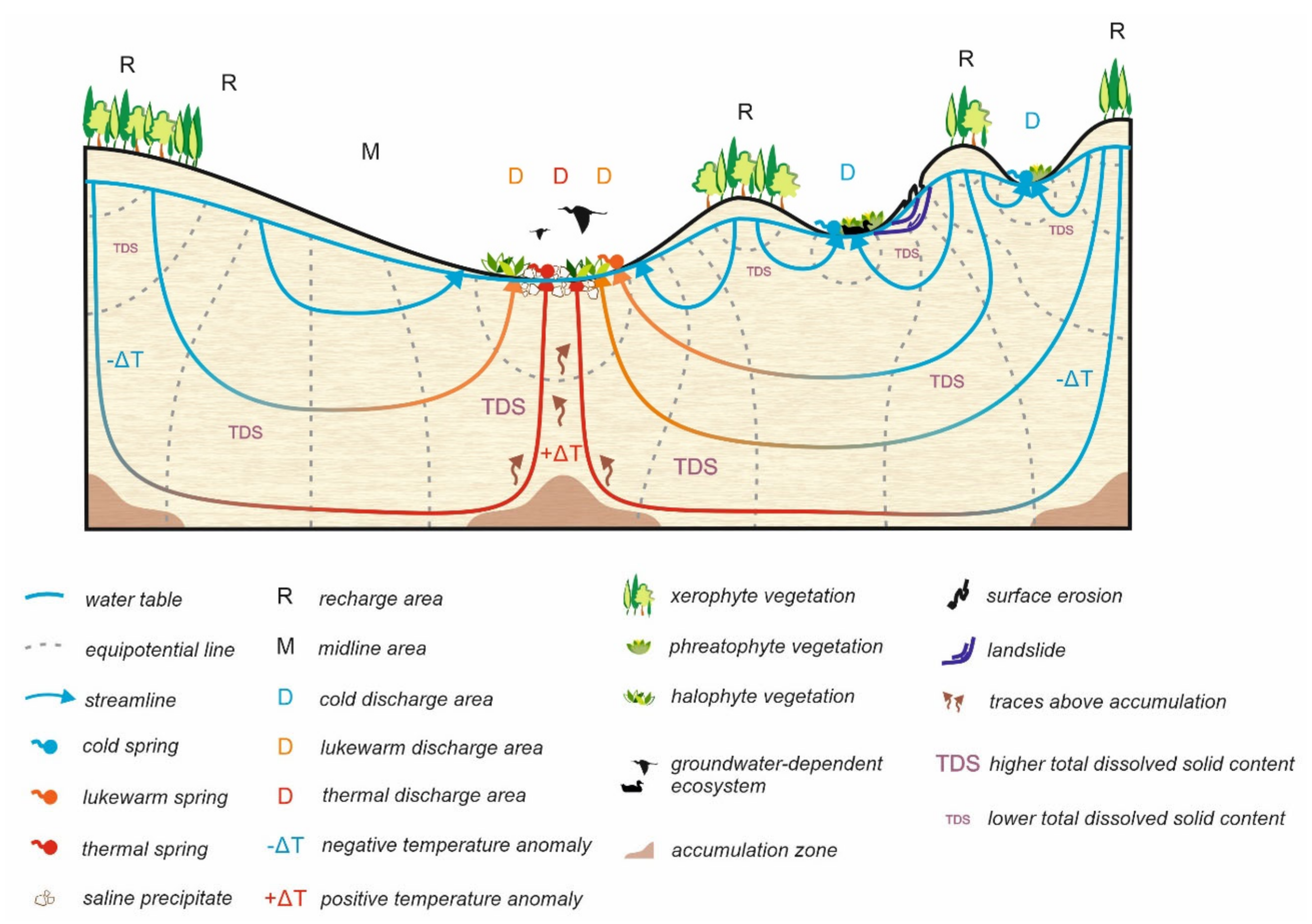
Fluids are kept in movement due to different driving forces. The most general and prevailing fluid flow driving force near surface in terrestrial regions (in mature, non-deforming basins) is the topography [15], i.e., the elevational differences of the watertable, which form gravitational or topography-driven flow systems [11]. In these systems, topographical highs represent recharge areas where infiltrating rainwater flows basically downward. On the other hand, topographical lows represent discharge areas where groundwater flows in an upward direction towards the land surface. The recharge and discharge areas are connected by midline or through-flow areas where the dominant flow direction is horizontal (Figure 1). In contrast with the theoretical ‘Unit basin’, which has a linearly dipping land surface [16], in ‘Composite basins’, the undulation of land surface results in hierarchically nested flow systems, namely local, intermediate and regional scale flow systems [17] (Figure 1). Geological heterogeneities such as structural elements, heterogeneity and anisotropy of sediments cause an even more complex flow pattern. In reality, an infinite variability of flow systems can exist due to differences in topography, climate and geology [18].

Figure 1.
Gravity-driven groundwater flow systems in sedimentary basins and the related natural phenomena (half-basin on the left-hand side: unit basin, half-basin on the right-hand side: composite basin) [19].
As a result of the spatial (basin) scale and time span (1–10 million years depending on basin evolution) of operation, the cross-formational flow and fluid-rock interactions, groundwater flow behaves as a geologic agent, which mobilizes, transports and deposits matter and heat [3]. In general, fluids flow from higher to lower fluid-potentials [20], while mobilization and deposition/accumulation are typical of zones of high and low fluid-potentials, respectively [3,21,22] (Hubbert 1956; Tóth 1980, 1999). Consequently, groundwater flow systems generate basin-scale distribution patterns and local-scale configurations of fluid-dynamic parameters and induce environmental and geological natural processes and phenomena. In other words, these genetically related manifestations of the groundwater flows’ geologic agency are characteristic for the recharge, midline and discharge areas, as well as for the local, intermediate and regional flow systems (Figure 1). Since groundwater flow paths can be evaluated quantitatively and in a distributed manner, it allows a site specific search for geofluid-related resources (e.g., groundwater, geothermal energy, hydrothermal minerals), which can be viewed simply as products of groundwater’s moving geologic agency.
Regional fluid flow driving forces other than topography could also work particularly in juvenile (i.e., deforming) basins, such as tectonic compression, compaction, erosion/rebound, buoyancy [15]. These flow systems can also be evaluated quantitatively and in a distributed manner allowing a site specific search for geofluid-related resources. In addition, interactions of superimposed flow systems with different driving forces can result in specific situations, such as regional fluid-potential minimum zones of converging flows, which can serve as hydraulic traps for matter and heat [23], or heat anomalies in basins where the fluids and heat distribution are driven by topography induced forced and/or superimposed free thermal convection [24,25]. Regional groundwater flow systems evolve continuously due to the changing driving forces and boundary conditions during the geological history of their host sedimentary basins [2]. Transient hydraulic and thermal conditions will evolve, for example, in response to a variety of changes including those related to climate, thermal conditions, sediment compaction, erosion, geochemical reactions, tectonic uplift and stress [1]. Understanding the paleo-flow history of geofluid systems, therefore, could help to explain the role of groundwater in several geologic processes such as hydrothermal flow and ore genesis.
2.2. System Approaches in Geofluid Research
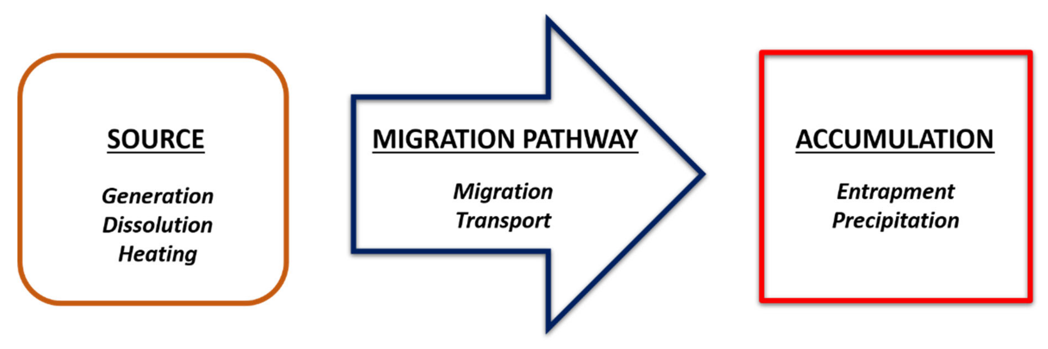
System approach is also applied in geothermal, mineral and petroleum exploration. Since the mineral system (MS) [26,27,28] and geothermal system (GS) [29] were based on the petroleum system (PS) [30] concept, their approaches and framework are similar. The analogous major elements and processes can be seen in Figure 2, whilst the details with the nomenclatural differences are in Table 1.

Figure 2.
Major ELEMENTS and Processes of petroleum, mineral and geothermal systems.

Table 1.
Comparison of the simplified elements and processes of petroleum, mineral and geothermal systems. Processes being not named in the original definitions are signed by italics. Groundwater flow systems can also be classified similarly.
The source reflects to the origin of fluids (PS, MS, GS), metals and other ore components (MS), and energy in the form of (magmatic) heat (MS, GS) or geodynamic-tectonic processes (MS). Processes regarding the source could be generation (PS), phase separation, dissolution and devolatilization (MS) and heating (GS). Migration pathways and reservoirs of geofluids and the transported matter and heat could be the high permeability rocks and faults, whilst flow barriers (seal) are the low permeability rocks and faults. Beyond the permeability constraint, migration and transport processes are derived by hydraulic, thermal, and concentration gradients. The major controlling factors of entrapment are the changes in permeability (MS, PS, GS), and the thermal and chemical conditions (e.g., geochemical traps, MS). Heat is highlighted in GS, but it also has a crucial role in PS (petroleum generation) and MS. In the last column of Table 1, the groundwater flow system (GWFS) elements and processes can be seen, which are not framed into that kind of a system such as PS, MS, GS, but can be arranged in the same way. It is also worth to note that the scale of critical elements and processes in these systems could be different; sources of fluids can be basin-wide, whereas accumulation-deposition is more localized as it is usually related to a focused flow of fluids and physical-chemical barriers forming traps.
Conclusively, (i) elements of the systems are basically common (i.e., the geological buildup), (ii) regional driving forces effects on all fluids, (iii) local processes are defined by thermal and other physical, as well as chemical, conditions, and fluid–rock interactions, (iv) whilst moving groundwater is the link between the different systems as being responsible for migration, thus matter and energy transport among the systems, and their interactions. Finally, it is worth mentioning that beyond these natural systems also human impacts and the effects of climate change must be considered. Groundwater flow systems exposed to these impacts also influence the environmental consequences and their mitigation [31].
3. Proposal for Geofluid Research
3.1. Dynamic System Approach for Geofluids and Their Resources
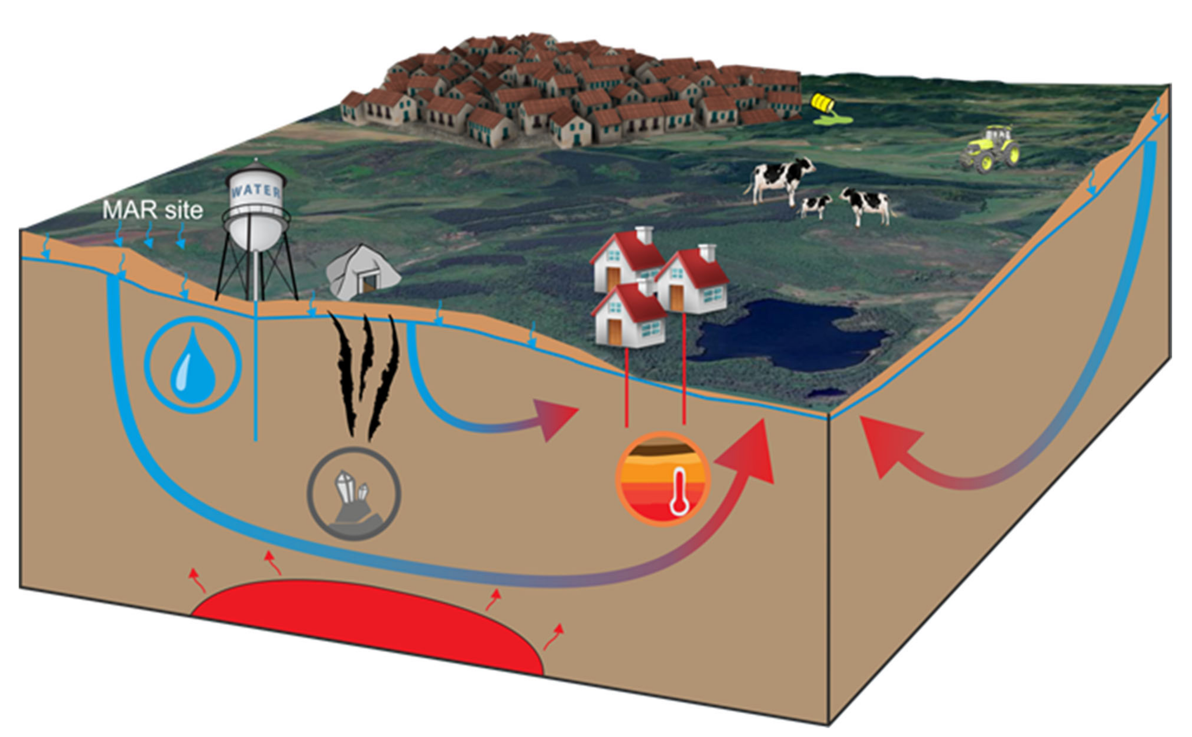
The concept of the DSA-GR of the ENeRAG project can efficiently combine and optimize the research and sustainable utilization of geofluids and the related groundwater, geothermal energy and mineral resources (Figure 3).

Figure 3.
Dynamic System Approach for Geofluids and their Resources (DSA-GR) (water, geothermal energy, minerals). Their relationships with each other and human activities: groundwater utilization, contamination, urban areas, geothermal heating and cooling, ecology, agriculture, mining, etc. Note: upper blue line divides the unsaturated zone filled with air and fluids (directly under the ground surface), and the fully fluid-saturated zone of geofluids (highlighted by blue). The small blue arrows represent infiltration across the unsaturated zone; MAR: Managed Aquifer Recharge site; the red color and red arrows in the underside of the figure represent magmatic source of heat and hydrothermal fluids; the continuous blue–orange–red lines represent the oversimplified geofluid dynamics.
The base and framework of DSA-GR are provided by the basin-scale groundwater flow systems. The incomparable strength of the dynamic groundwater flow system approach lies in the handling of migration, namely that migration pathways of fluids or groundwater flow paths, which transport matter and heat, can be evaluated quantitatively and in a distributed manner (see Section 2 and Section 3.2.2). As a result, it allows a site specific search for geofluid-related resources (e.g., groundwater, geothermal energy, hydrothermal minerals), which can be viewed simply as products of groundwater’s moving geologic agency. The DSA-GR offers new approaches for geofluid research by combining interdisciplinary methods in order to jointly manage all types of geofluids, the related resources and environmental consequences in the Earth’s crust.
3.2. Workflow and Guideline for Geofluid Research
The aim of this sub-chapter is to provide a workflow and guidelines for the innovative combination of advanced research methods below the umbrella theory of DSA-GR (ENeRAG ®). Accordingly, the innovative approach and combination of methods are in the central focus instead of the methodological details.
3.2.1. Workflow for Geofluid Research
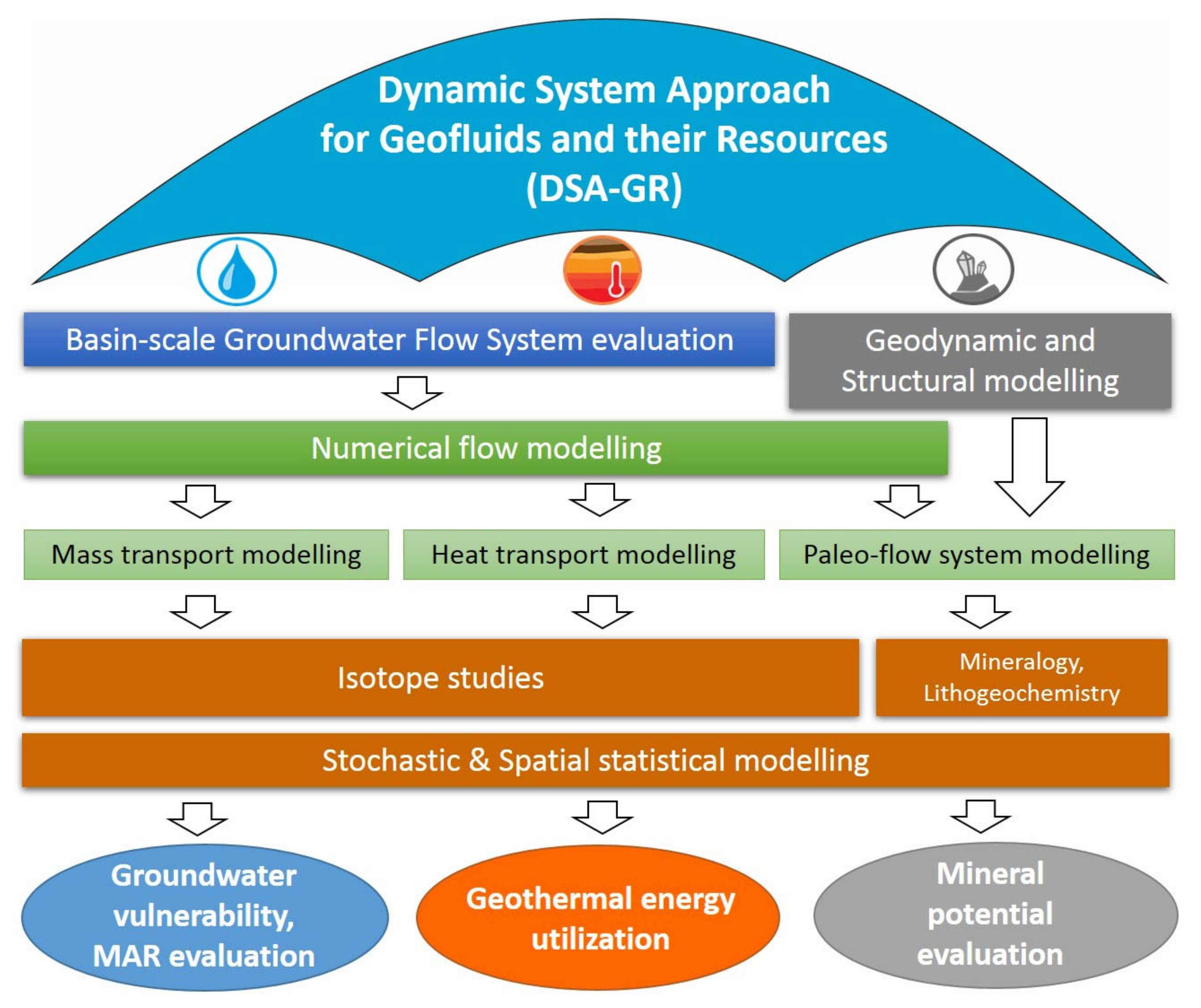
Figure 4 represents how the research methodologies build upon each other. The process starts from the regional scale groundwater flow system analysis based on the DSA-GR towards the local scale practical application areas of, for instance, groundwater vulnerability, Managed Aquifer Recharge (MAR), geothermal energy utilization, and evaluation of hydrothermal mineral potential.

Figure 4.
Workflow for geofluid research.
- (1)
- Basin-scale groundwater flow system evaluation (Figure 4) means the understanding of the pathways and processes of a basin-scale groundwater flow based on the complex analysis of: (i) measured data (hydraulic, temperature, hydrochemical), (ii) hydrostratigraphic build up (characterization of aquifers and aquitards), and (iii) the past and present groundwater flow related phenomena and processes. The evaluation results in a so-called “real flow system model”. It provides the boundary conditions and validation for the subsequent numerical simulations of past, present and future flow systems. (ENeRAG examples for application: [32,33,34,35]).
- (2)
- Numerical flow modeling of steady-state and transient groundwater flow pathways and intensities provides the base for transport modeling of mass (conservative or reactive) and heat, and paleo flow system modeling. (ENeRAG examples for application: [24,25,36,37,38,39].)
- (3)
- Mass or contaminant transport simulations can be used for instance in groundwater vulnerability assessment and Managed Aquifer Recharge (MAR) evaluation, whilst heat transport simulations can be applied for instance in geothermal (groundwater and bedrock) energy utilization. (ENeRAG examples for application: [25,36,40,41,42,43].)
- (4)
- Paleo flow system modeling requires preliminary geodynamic and structural modeling, then complemented with mineralogical and lithogeochemical studies it can be used for target generation in mineral exploration (ENeRAG examples for application: [44,45].)
- (5)
- Use of stable, radioactive and radiogenic isotopes as environmental tracers, as well as stochastic and spatial statistical modeling can significantly improve the modeling results, such as groundwater vulnerability and mineral potential evaluation. (ENeRAG examples for application: [41,42,43,46,47,48].)
Accordingly, numerical methods (2–5) with a real flow system backup (1) can efficiently simulate migration (flow and transport) processes allowing a site specific search for geofluid related resources and solving environmental problems.
3.2.2. Detailed Methodological Guidelines
The complex workflow for a basin-scale groundwater flow system evaluation can be seen in Figure 5, while the methodological details are in Table 2.
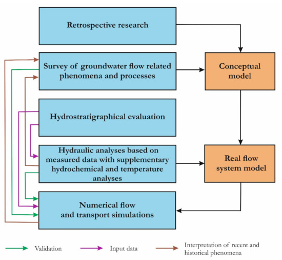
Figure 5.
Workflow for basin-scale groundwater flow system evaluation (modified after [50]) (see Table 2 for details).
Table 2.
Objective, approaches and methods of basin-scale groundwater flow system evaluation. * Geofluid-related resources, which are in the focus of the ENeRAG project, belong to these groups.
Examples of practical applications related to groundwater processes’ modeling (in both the saturated and unsaturated zone) and to statistical methods for MAR-systems and groundwater vulnerability studies are given in Table 3, Table 4 and Table 5.
Table 3.
Numerical modeling of the vadose zone combined with environmental tracers. General purposes: (I) Interpretation: models are applied to help the interpretation of processes as described by field or laboratory data; (D) Design: models are applied to evaluate and compare the performance of design alternatives; (P) Prediction: models are applied to provide a final, quantifiable prediction of actual field behavior.
Table 4.
Numerical modeling of the saturated zone combined with environmental tracers. General purposes: (I) Interpretation: models are applied to help the interpretation of processes as described by field or laboratory data; (D) Design: models are applied to evaluate and compare the performance of design alternatives; (P) Prediction: models are applied to provide a final, quantifiable prediction of actual field behavior.
Table 5.
Statistical groundwater vulnerability assessment. General purposes: (I) Interpretation: models are applied to help the interpretation of processes as described by field or laboratory data; (D) Design: models are applied to evaluate and compare the performance of design alternatives; (P) Prediction: models are applied to provide a final, quantifiable prediction of actual field behavior.
Examples of shallow geothermal (groundwater and bedrock) energy evaluation particularly based on numerical methods are presented in Table 6. Examples of deep geothermal energy evaluation based on a groundwater flow system evaluation are displayed in Table 7.
Table 6.
Shallow geothermal energy evaluation.
Table 7.
Deep geothermal energy evaluation.
Finally, exploration models, approaches and methods of a mineral system approach can be found in Table 8. The modeling objectives can be presented by critical parameters on maps allowing target generation for mineral exploration by the incorporation of mappable parameters into computerized mineral prospectivity mapping [49].
Table 8.
Exploration models, approaches and methods of mineral system approach.
4. Conclusions
Sustainable geofluid (e.g., groundwater, geothermal and hydrothermal fluids) management is calling for new, innovative, interdisciplinary and cost-effective approaches and solutions which also reflect to the challenges of climate and global changes. Accordingly, the proposed ‘Dynamic System Approach for Geofluids and their Resources’ (DSA-GR) offers a novelty approach and a guideline of the integration of the advanced methodology for the harmonized research and utilization of groundwater, geothermal energy and hydrothermal mineral resources. In addition, any other geofluids such as petroleum or contaminants could be handled by the DSA-GR, providing further prospects in the application, for instance, of the energy transition, carbon sequestration, or in the protection and restoration of groundwater dependent ecosystems.
Author Contributions
Conceptualization, B.C. and J.M.-S.; writing—original draft preparation, B.C., F.M., M.M., T.A. and J.M.-S. All authors have read and agreed to the published version of the manuscript.
Funding
The study was funded by the ENeRAG project which received funding from the European Union’s Horizon 2020 research and innovation program under Grant Agreement No. 810980.
Institutional Review Board Statement
Not applicable.
Informed Consent Statement
Not applicable.
Data Availability Statement
Not applicable.
Acknowledgments
The authors appreciate the contribution of all ENeRAG participants from the Eötvös Loránd University (Hungary), the Geological Survey of Finland (Finland), and the University of Milan (Italy).
Conflicts of Interest
The authors declare no conflict of interest.
References
- Deming, D. Introduction to Hydrogeology; McGraw-Hill College: New York, NY, USA, 2002; 480p. [Google Scholar]
- Ingebritsen, S.E.; Sanford, W.; Neuzil, C. Groundwater in Geological Processes, 2nd ed.; Cambridge University Press: Cambridge, UK, 2006. [Google Scholar]
- Tóth, J. Groundwater as a geologic agent: An overview of the causes, processes, and manifestations. Hydrogeol. J. 1999, 7, 1–14. [Google Scholar] [CrossRef]
- Tissot, B.P.; Welte, D.H. A New Approach to Oil and Gas Exploration; Springer: Berlin/Heidelberg, Germany; New York, NY, USA, 1978; pp. 105–109. [Google Scholar]
- Brace, W.F. Permeability of crystalline and argillaceous rocks. Int. J. Rock Mech. Min. Sci. Geomech. Abstr. 1980, 17, 241–251. [Google Scholar] [CrossRef]
- Neuzil, C.E. Groundwater flow in low-permeability environments. Water Resour. Res. 1986, 22, 1163–1195. [Google Scholar] [CrossRef]
- Neuzil, C.E. How permeable are clays and shales? Water Resour. Res. 1994, 30, 145–150. [Google Scholar] [CrossRef]
- Jiang, X.W.; Cherry, J.; Wan, L. Flowing wells: Terminology, history and role in the evolution of groundwater science. Hydrol. Earth Syst. Sci. 2020, 24, 6001–6019. [Google Scholar] [CrossRef]
- Witherspoon, P.A.; Neuman, S.P. Evaluating a slightly permeable caprock in aquifer gas storage: I. Caprock of infinite thickness. Trans. Am. Inst. Min. Eng. 1967, 240, 949–955. [Google Scholar] [CrossRef]
- Tóth, J. Hydraulic continuity in large sedimentary basins. Hydrogeol. J. 1995, 3, 4–16. [Google Scholar] [CrossRef]
- Tóth, J. Gravitational Systems of Groundwater Flow—Theory, Evaluation, Utilization; University Press: Cambridge, UK, 2009; 310p. [Google Scholar]
- Bredehoeft, J.D. The Toth Revolution. Groundwater 2018, 56, 157–159. [Google Scholar] [CrossRef] [PubMed] [Green Version]
- Zijl, W. Creep Flow Systems in the Earth Crust: A Complement to Groundwater Flow Systems. Geophys. Res. Abstr. 2019, 21, 1. [Google Scholar]
- Mádl-Szőnyi, J.; Czauner, B.; Iván, V.; Tóth, Á.; Simon, S.; Erőss, A.; Bodor, P.; Havril, T.; Boncz, L.; Sőreg, V. Confined carbonates—Regional scale hydraulic interaction or isolation? Mar. Petrol. Geol. 2019, 107, 591–612. [Google Scholar] [CrossRef]
- Garven, G. Continental-scale groundwater flow and geologic processes. Annu. Rev. Earth Planet. Sci. 1995, 23, 89–117. [Google Scholar] [CrossRef]
- Tóth, J. A theory of groundwater motion in small drainage basins in central Alberta, Canada. J. Geophys. Res. 1962, 67, 4375–4388. [Google Scholar] [CrossRef]
- Tóth, J. A theoretical analysis of groundwater flow in small drainage basins. J. Geophys. Res. 1963, 68, 4795–4812. [Google Scholar] [CrossRef]
- Tóth, J. Groundwater discharge: A common generator of diverse geologic and morphologic phenomena. Hydrol. Sci. J. 1971, 16, 7–24. [Google Scholar] [CrossRef]
- Tóth, Á.; Havril, T.; Simon, S.; Galsa, A.; Santos, F.A.M.; Müller, I.; Mádl-Szőnyi, J. Groundwater flow pattern and related environmental phenomena in complex geologic setting based on integrated model construction. J. Hydrol. 2016, 539, 330–344. [Google Scholar] [CrossRef]
- Hubbert, M.K. The theory of ground-water motion. J. Geol. 1940, 48, 785–944. [Google Scholar] [CrossRef]
- Hubbert, M.K. Entrapment of petroleum under hydrodynamic conditions. AAPG Bull. 1956, 37, 1954–2026. [Google Scholar]
- Tóth, J. Cross-formational gravity-flow of groundwater: A mechanism of the transport and accumulation of petroleum (the generalized hydraulic theory of petroleum migration). In Problems of Petroleum Migration, Studies in Geology; Roberts, W.H., III, Cordell, R.J., Eds.; AAPG: Tulsa, OK, USA, 1980; pp. 121–167. [Google Scholar]
- Czauner, B.; Mádl-Szőnyi, J. Regional hydraulic behavior of structural zones and sedimentological heterogeneities in an overpressured sedimentary basin. Mar. Petrol. Geol. 2013, 48, 260–274. [Google Scholar] [CrossRef]
- Szijártó, M.; Galsa, A.; Tóth, Á.; Mádl-Szőnyi, J. Numerical investigation of the combined effect of forced and free thermal convection in synthetic groundwater basins. J. Hydrol. 2019, 572, 364–379. [Google Scholar] [CrossRef]
- Szijártó, M.; Galsa, A.; Tóth, Á.; Mádl-Szőnyi, J. Numerical analysis of the potential for mixed thermal convection in the Buda Thermal Karst, Hungary. J. Hydrol. Reg. Stud. 2021, 34, 100783. [Google Scholar] [CrossRef]
- Wyborn, L.A.I.; Heinrich, C.A.; Jaques, A.L. Australian Proterozoic Mineral Systems: Essential ingredients and mappable criteria. In Proceedings of the AusIMM Annual Conference, Darwin, NT, Australia, 5–9 August 1994; pp. 109–115. [Google Scholar]
- McCuaig, T.C.; Beresford, S.; Hronsky, J. Translating the mineral system approach into an effective exploration targeting system. Ore Geol. Rev. 2010, 38, 128–138. [Google Scholar] [CrossRef]
- McCuaig, C.; Hronsky, J. The Mineral System Concept: The Key to Exploration Targeting. In Building Exploration Capability for the 21st century; Kelly, K.D., Golden, H.C., Eds.; Society of Economic Geologists: Littleton, CO, USA, 2014; pp. 153–175. [Google Scholar]
- Moeck, I.S. Catalog of geothermal play types based on geologic controls. Renew. Sustain. Energy Rev. 2014, 37, 867–882. [Google Scholar] [CrossRef] [Green Version]
- Magoon, L.B.; Dow, W.G. The petroleum system. In The Petroleum System—From Source to Trap; Magoon, L.B., Dow, W.G., Eds.; AAPG Special Volumes: Washington, DC, USA, 1994; Volume 60, pp. 3–24. [Google Scholar]
- IAH (International Association of Hydrogeologists). Strategic Overview Series. Available online: https://iah.org/education/professionals/strategic-overview-series (accessed on 29 January 2022).
- Mádlné Szőnyi, J. A regionális pórusnyomásviszonyok jelentősége a termálvíz feltárásban és a készletek megújulásában. Magyar Tudomány 2019, 180, 1796–1807. [Google Scholar]
- Czauner, B.; Mádlné Szőnyi, J. Szemelvények az elmúlt két évtized ELTE-n végzett, medenceléptékű hidrogeológiai kutatásaiból. Földtani Közlöny 2020, 150, 545–570. [Google Scholar] [CrossRef]
- Csondor, K.; Czauner, B.; Csobaji, L.; Győri, O.; Erőss, A. Characterization of the regional groundwater flow systems in south Transdanubia (Hungary) to understand karst evolution and development of hydrocarbon and geothermal resources. Hydrogeol. J. 2020, 28, 2803–2820. [Google Scholar] [CrossRef]
- Garamhegyi, T.; Székely, F.; Carrillo-Rivera, J.J.; Mádl-Szőnyi, J. Revision of archive recovery tests using analytical and numerical methods on thermal water wells in sandstone and fractured carbonate aquifers in the vicinity of Budapest, Hungary. Environ. Earth Sci. 2020, 79, 129. [Google Scholar] [CrossRef] [Green Version]
- Szijártó, M.; Galsa, A. Termohalin konvekció numerikus vizsgálata porózus közegmodellben. Magyar Geofizika 2020, 61, 177–190. [Google Scholar]
- Tóth, Á.; Galsa, A.; Mádl-Szőnyi, J. Significance of basin asymmetry and regional groundwater flow conditions in preliminary geothermal potential assessment—Implications on extensional geothermal plays. Glob. Planet. Change 2020, 195, 103344. [Google Scholar] [CrossRef]
- Modrovits, K.; Csepregi, A.; Kovácsné Székely, I.; Hatvani, I.G.; Kovács, J. Comparison of Various Growth Curve Models in Characterizing and Predicting Water Table Change after Intensive Mine Dewatering Is Discontinued in an East Central European Karstic Area. Water 2021, 13, 1047. [Google Scholar] [CrossRef]
- Pedretti, D.; Vriens, B.; Skierszkan, E.K.; Baják, P.; Mayer, K.U.; Beckie, R.D. Evaluating dual-domain models for upscaling multicomponent reactive transport in mine waste rock. J. Contam. Hydrol. 2022, 244, 103931. [Google Scholar] [CrossRef]
- Szabó, Z.; Tahy, Á.; Mádlné Szőnyi, J. A célzott felszínalatti vízutánpótlás nemzetközi trendjei és hazai alkalmazási lehetőségei. Hidrológiai Közlöny 2019, 100, 40–51. [Google Scholar]
- Dalla Libera, N.; Pedretti, D.; Casiraghi, G.; Markó, Á.; Piccinini, L.; Fabbri, P. Probability of Non-Exceedance of Arsenic Concentration in Groundwater Estimated Using Stochastic Multicomponent Reactive Transport Modeling. Water 2021, 13, 3086. [Google Scholar] [CrossRef]
- Hayat, S.; Szabó, Z.; Tóth, Á.; Mádl-Szőnyi, J. MAR Site Suitability Mapping for Arid-Semiarid Regions by Remote Data and Combined Approach: A Case Study from Balochistan, Pakistan. Acque Sotterranee Ital. J. Groundwater 2021, 10, 17–28. [Google Scholar] [CrossRef]
- Baják, P.; Csondor, K.; Pedretti, D.; Muniruzzaman, M.; Surbeck, H.; Izsák, B.; Vargha, M.; Horváth, Á.; Pándics, T.; Erőss, A. Refining the conceptual model for radionuclide mobility in groundwater in the vicinity of a Hungarian granitic complex using geochemical modeling. Appl. Geochem. 2022, 137, 105201. [Google Scholar] [CrossRef]
- Kiss, G.B.; Bendő, Z.; Garuti, G.; Zaccarini, F.; Király, E.; Molnár, F. Reconstruction of Hydrothermal Processes in the Cyprus Type Fe-Cu-Zn Deposits of the Italian Northern Apennines: Results of Combined Fluid Inclusion Microthermometry, SEM-CL Imaging and Trace Element Analyses by LA-ICP-MS. Minerals 2021, 11, 165. [Google Scholar] [CrossRef]
- Molnár, Z.; Kiss, G.B.; Molnár, F.; Váczi, T.; Czuppon, G.; Dunkl, I.; Zaccarini, F.; Dódony, I. Epigenetic-Hydrothermal Fluorite Veins in a Phosphorite Deposit from Balaton Highland (Pannonian Basin, Hungary): Signatures of a Regional Fluid Flow System in an Alpine Triassic Platform. Minerals 2021, 11, 640. [Google Scholar] [CrossRef]
- Iván, V.; Stevenazzi, S.; Pollicino, L.C.; Masetti, M.; Mádl-Szőnyi, J. An Enhanced Approach to the Spatial and Statistical Analysis of Factors Influencing Spring Distribution on a Transboundary Karst Aquifer. Water 2020, 12, 2133. [Google Scholar] [CrossRef]
- Csondor, K.; Baják, P.; Surbeck, H.; Izsák, B.; Horváth, Á.; Vargha, M.; Erőss, A. Transient nature of riverbank filtered drinking water supply systems—A new challenge of natural radioactivity assessment. J. Environ. Radioact. 2020, 211, 106072. [Google Scholar] [CrossRef]
- Csondor, K.; Baják, P.; Surbeck, H.; Izsák, B.; Horváth, Á.; Vargha, M.; Pándics, T.; Erőss, A. Parti szűrésű vízbázisok természetes radioaktivitása nuklidspecifikus mérések tapasztalatai alapján (Natural radioactivity of riverbank filtered water systems based on the experience of nuclid specific measurements). Hidrológiai Közlöny 2021, 101, 44–53. [Google Scholar]
- Torppa, J.; Nykanen, V.; Molnár, F. Unsupervised clustering and empirical fuzzy memberships for mineral prospectivity modelling. Ore Geol. Rev. 2019, 107, 28–71. [Google Scholar] [CrossRef]
- Mádlné Szőnyi, J. Felszínalatti Vízáramlások Mintázata Fedetlen és Kapcsolódó Fedett Karbonátos Víztartó Rendszerekben a Budai-Termálkarszt Tágabb Környezetének Példáján. Ph.D. Thesis, Hungarian Academy of Sciences, Budapest, Hungary, 2020; 131p. [Google Scholar]

Publisher’s Note: MDPI stays neutral with regard to jurisdictional claims in published maps and institutional affiliations. |
© 2022 by the authors. Licensee MDPI, Basel, Switzerland. This article is an open access article distributed under the terms and conditions of the Creative Commons Attribution (CC BY) license (https://creativecommons.org/licenses/by/4.0/).