Abstract
Urban waterlogging has risen to be an urgent problem awaiting solutions in China these years, and “infiltration”, “storage”, and “drainage” are considered the major and most direct measures against this problem. In the present work, the waterlogging alleviation mechanism of these three measures is analyzed; and with Huangbian Village in Panyu District of Guangzhou, China, as a study case, one-dimensional, two-dimensional, and pipe network coupling hydrodynamic models were established to explore the optimal schemes of “infiltration”, “storage”, “drainage” measures against urban waterlogging and which measure is the most effective one, providing a reference for scientific prevention and alleviation of urban waterlogging in cities. Effect assessment shows that the “storage” is the most effective measure because reducing the impermeability near the waterlogged site, deploying storage tanks upstream of the waterlogged site, and in the case of submerged discharge, lowering the downstream water level can reduce the waterlogged area by 16%, 81%, and 16%, respectively. The comprehensive measures of “infiltration”, “storage”, and “drainage” reduced the waterlogged area by 87%, which is superior to a single measure. The present work is expected to provide some reference for the prevention and alleviation of urban waterlogging in cities on a plain with intensive river networks.
1. Introduction
In these years, Chinese cities are seeing more and more waterlogging disasters (Heavy rainfall or continuous rainfall exceeds the absorption capacity of rainwater facilities of a city, resulting in ponding on the ground.), which curb economic growth and social progress [1]. Since the release of “Technical Guideline for Sponge City Construction” in 2014 [2], methods such as discharge reduction at the source, runoff control, rainwater regulation, and storage are combined with measures including “infiltration”, “detention”, “storage”, “purification”, “use”, and “drainage” of rainwater to improve the water cycle in sponge cities, and the theory of low-impact development (LID) that intends to improve the city’s capacity for infiltration, regulation and storage, purification, use and drainage of surface runoff and rainwater has become a guiding rule for urban construction and waterlogging alleviation [3]. The measure of “detention”, which aims to retain the rainwater, shares the same idea with stormwater storage, both of which are small-scale attempts; “use” aims to recycle the rain and flood resources; “purification” is intended to reduce the impact of rain-induced pollution on the city’s water environment; the other three measures—“infiltration” that controls runoff production and cuts the flood peak, “storage” that stores water during rainfalls and floods, and “drainage” that aims to extend the capacity of the city’s drainage systems—are the most direct and most crucial measures against urban waterlogging [4].
Some have probed into low-impact development (LID) methods against the problem of waterlogging. Firoozabadi et al. [5] studied the optimal scheme to reduce the urban flood risk, and the results show that the permeable pavement scheme has the lowest risk. Cristiano et al. [6] studied the effectiveness of blue–green systems in reducing urban flooding and showed that extensive rainwater collection systems, combined with green roofs, can reduce extreme rainfall runoff by 5% to 15%. Meng et al. [7] analyzed the impact of LID measures on waterlogging alleviation and found that the effect of LID measures declined with the increase in the rainfall return periods. Fei et al. [8] studied the sensitivity of flood-causing elements and revealed that a 10–15% decrease in impermeability could reduce the accumulated water in waterlogged regions by 40–50%. Jiao et al. [9] explored the effect of LID infrastructure from the perspective of rainfall and flood control and determined the location and scale of LID facilities in Sutuoyuan wetland in Changsha, Hunan province, China. Hu [2] made a case study of a densely populated old-town region in Guangzhou to simulate and evaluate the effect of different LID facilities on runoff control during rainfalls of different intensities.
The stormwater storage tank can, by increasing the water storage volume of the rainfall control system, cut the flood peak, and reduce the flow and water level in downstream drainage pipes. The effect of storage tanks relies heavily on how they are spatially deployed, and hence the spatial deployment of storage tanks has drawn increasing attention among researchers worldwide. Liao et al. [10] analyzed the hydrological mechanism under which the stormwater storage facilities curtail floods and found that it is better to allocate storage tanks in the up- and mid-stream than the downstream of the urban drainage system. Wu et al. [11] concluded from real-world engineering study cases that decentralized deployment of storage tanks achieves a better effect than the centralized allocation in stormwater regulation; though the two deployment patterns show little difference in the volume of water storage, the decentralized pattern can reduce the size of single storage tanks, and hence is more feasible in regions of a limited area of usable land. Jemberie et al. [12] determined that comprehensive measures of “infiltration” and “storage” can reduce the peak of urban floods by 75%.
Improving the drainage capacity of the urban drainage system is necessary to address the problem of urban waterlogging. Deng et al. [13] analyzed the impact of urban drainage system construction on urban waterlogging and found that constructing drainage systems the downstream of the pipe network and lowering the water level of the river channels can considerably mitigate urban waterlogging, but other factors such as the longitudinal gradient of the river channel and the pipe network, the connectivity between the pipe network and the river channel also play a role.
With Huangbian Village in Panyu District, Guangzhou, China, as the study case, the present work explores the optimal schemes of urban waterlogging alleviation measures, including infiltration, storage, and drainage. Moreover, as LID facilities cannot be widely deployed in urban regions short of an area of usable land, optimized deployment schemes of LID facilities are explored. Based on analyses of the hydrological mechanism of storage tanks in mitigating flood disasters, the allocation schemes of storage tanks are identified according to the drainage capacity of urban pipe networks and the distribution of waterlogged regions, and the optimized allocation schemes of storage tanks are also explored. Given the characteristics of cities in flatland, such as small longitudinal gradients of river channels and pipe networks, a significant jacking effect from downstream backwater on the water system and pipe drainage system and the effect of lowering the water level on the downstream of the drainage pipeline on waterlogging alleviation is analyzed. Finally, the effect of the scheme combining all three measures—infiltration, storage, and drainage—on waterlogging alleviation is analyzed.
This paper studies optimal schemes of “infiltration”, “storage”, and “drainage” and finds out which one is the most effective in waterlogging alleviation and should be the main measure while others are alternatives. The research results can provide a reference for scientific prevention and alleviation of urban waterlogging in cities.
2. Study Area
Huangbian Village, located in the midsouth of Guangzhou, belongs to the Shiqiao neighborhood of Panyu District, covering an area of 0.4 km2 and accommodating a population of 9630. Surrounded by Donghuan Road, Dexing North Road, Fuhuang East Road, and Dabei Road, the village is encircled by built-up regions and accounts for a typical “urban village” in Guangzhou (Figure 1). With four sides higher than the middle part, the village has a saucer-shaped terrain, with a sea-level elevation of merely 4.7–9.0 m, in contrast to an elevation of 8.1–20.0 m of the surrounding roads. The drainage pipe networks of the village and surrounding areas form a combined drainage system. The drainage system in upstream consists of three sub-regions: the north region, east region, and south region, which have a water catchment area of 13.48 hm2, 11.56 hm2, and 29.31 hm2, respectively. In the northern sub-region, the pipe network is allocated along the northern part of Donghuan Road and Huanbian New Road, and the water flows southwards from the north; in the eastern sub-region, the water flows westwards from the east along Dexing North Road and Huangbian Street; in the southern sub-region, the water flows northwards from the south along Huangbian New Road. Water in these three sub-regions converges at the intersection between Huangbian Street and Huangbian New Road, which then flows westwards to Huangbianchong along Huangbian Street before entering the Danshan River. The water level of the Danshan River is subject to the influence of downstream sluices and tides, which has significant jacking effects on the pipe network of Huangbian Village and the surrounding areas. With a disc-shaped landform, the village sees a severe inflow of rainwater from adjacent regions during rainfalls, which, combined with the jacking effect of the Danshan River, results in severe waterlogging disasters in the village. The frequent outbursts of waterlogging disasters have posed a serious threat to local social and economic development.
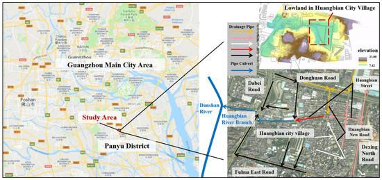
Figure 1.
Location of the study area.
3. Modeling
One-dimensional, two-dimensional, and pipe network coupling hydrodynamic models have already been widely used in works on waterlogging alleviation [14,15]. In the present work, the MIKE software was employed to create coupling models to simulate waterlogging in Huangbian Village in the Panyu District of Guangzhou. Based on the 2014 version of the MIKE FLOOD platform, this study coupled with the one-dimensional hydrodynamic model (MIKE 11), the two-dimensional hydrodynamic model (MIKE 21), and the pipe network model (MIKE URBAN). MIKE FLOOD is a coupled simulation platform that reflects the performance of water flow in the pipeline and surface water in the urban area. This platform extends the simulation ability of the traditional urban drainage system pipe network model, so it can accurately reflect water flow movement in an urban drainage network and simulate the interaction between pipe water flow and surface water as well as other conditions [16].
The models were built based on data of the landform, river channels, and pipe network of the study area; the pipe network, division of catchment areas, underlying surface, and other factors were analyzed first, and then secondary models, including the pipe network model of runoff production and confluence, the one-dimensional model for the confluence of river channels, and the two-dimensional model for surface sheet flood, were built and coupled to generate an urban waterlogging simulation model. The simulation model was then used to simulate multiple waterlogging scenarios with data on rainfall, water level, and flow of river channels, analyze the degree of fullness of the pipe network and the area of waterlogged regions, and evaluate the effect of different schemes against waterlogging.
3.1. Construction of Coupling Models
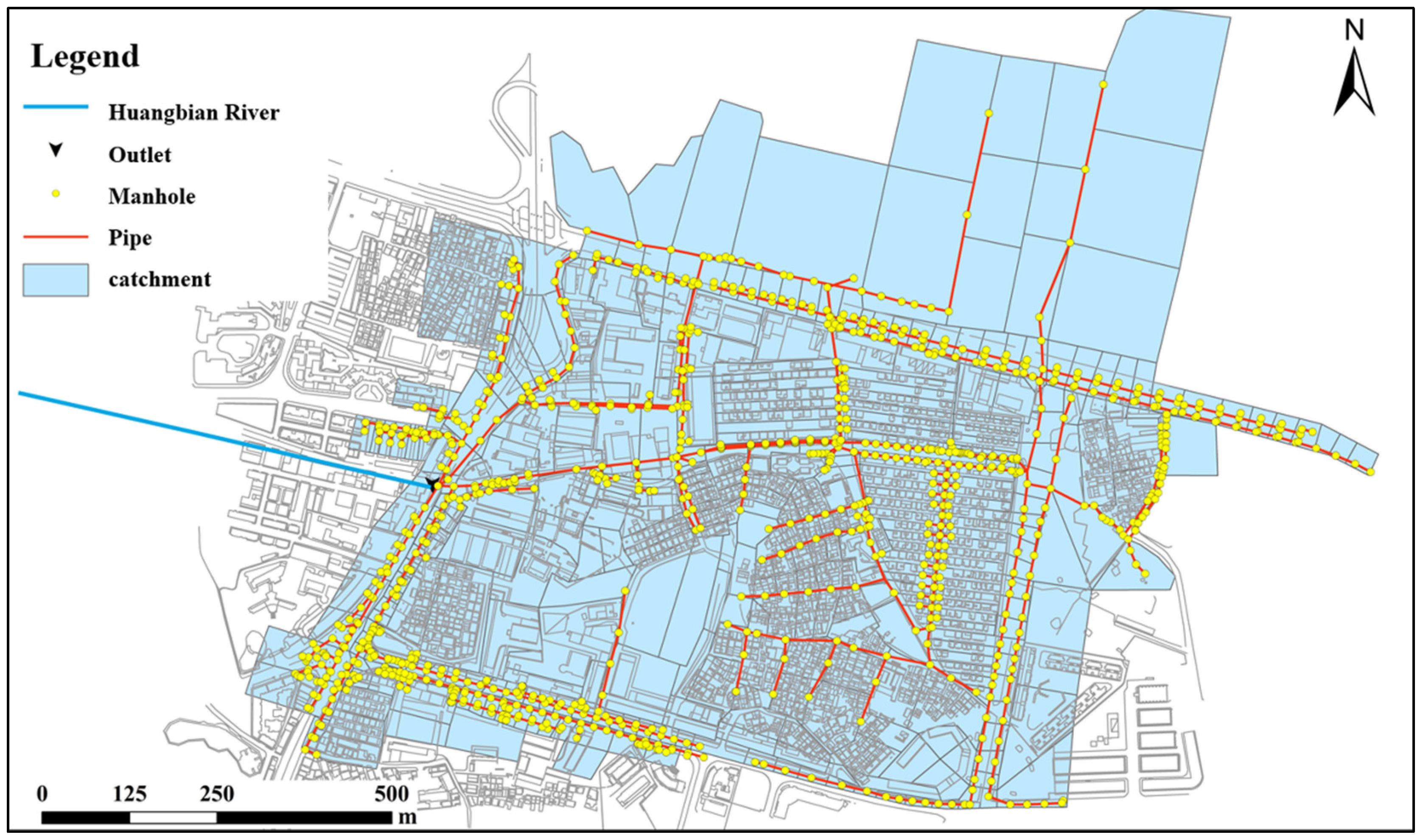
With Huangbian Village as the study case, the MIKE software was employed to create one-dimensional, two-dimensional, and pipe network hydrodynamic models to explore the optimal waterlogging alleviation schemes combining infiltration, storage, and drainage measures. To simulate the jacking effect of the water level of downstream river channels on the pipe network, a one-dimensional model of river channels in Huangbianchong was built, which covers an 845-m-long pipe network from the drainage outfall of Huangbian Village to the junction of Hunagbianchong with Danshan River; the downstream water-level limit was determined based on the measured water level of Danshan River, and the upstream water level was identified by coupling with the pipe network model. A two-dimensional model was built to simulate surface sheet flood and the waterlogging process, which covers a scope of 66.98 hm2 divided into 365 × 643 orthogonal grids, and the elevation of the sites of buildings was increased. A pipe network model was built to simulate the runoff production and confluence processes of Huangbian Village and its surrounding areas and the flood drainage process of the pipe network. The measured geographic data were used to divide the sub-catchment areas, and data about the underlying surface were used to identify the impermeability of each sub-catchment area. The model covers 104.17 hm2, involving 389 sub-catchment areas, 989 tube wells, and 956 pipes (Figure 2).
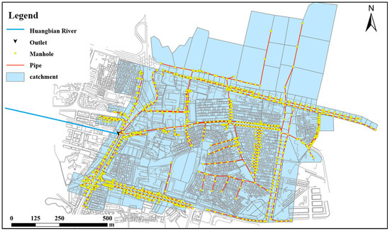
Figure 2.
Schematic of Huangbian Village pipe network model.
The coupling model was obtained by coupling the aforementioned three models. The one-dimensional model for river channels, the two-dimensional model for the ground surface, and the pipe network model. The coupling of the pipe network model and the two-dimensional model was realized by tube wells: the sheet flood generated from the overloaded drainage pipe network will spread to the ground surface through the tube wells, which flows to the low-lying area and therefore causes waterlogging. The coupling between the pipe network model and the one-dimensional model was realized by the stormwater drainage outfall: the drainage network collects and delivers the rainwater to the river, causing an increase in the water level of the river; in return, an increased water level of the river will impede the drainage the pipe network. Coupling between the one-dimensional river-channel model and the two-dimensional ground surface model was realized through the riverbank: when the flow exceeds the discharge capacity of the river channel, the stormwater will be spread to lower-lying areas along the river bank and then return to the river channel.
3.2. Model Calibration and Verification
As there were few measured data about waterlogging in the study area, historical data about the waterlogging sites during the rainstorm on 13 April 2012 and 10 May 2016 were employed to calibrate and verify the model. Data about the rainstorm on 13 April 2012 were used to calibrate the model parameters: from 15:00 to 17:00 on 13th April, the precipitation reached 79.2 mm, with the maximum precipitation for five minutes at 19.1 mm. Table 1 shows the comparison between the simulated maximum inundation depth and the measured value. The rainstorm data on 10 May 2016 were used to verify the simulation model: from 4:00 to 6:00 on 10 May 2016, the precipitation reached 78.3 mm, with the maximum precipitation for five minutes at 12.5 mm; the simulated maximum inundation depth and the measured value are also displayed in Table 1. As Table 1 shows, the simulated maximum inundation depth is basically aligned with the measured value of the waterlogging sites, with an error below 10 cm.

Table 1.
Model calibration and verification.
4. Effects of Single-Measure Schemes
4.1. Design of Waterlogging Alleviation Schemes
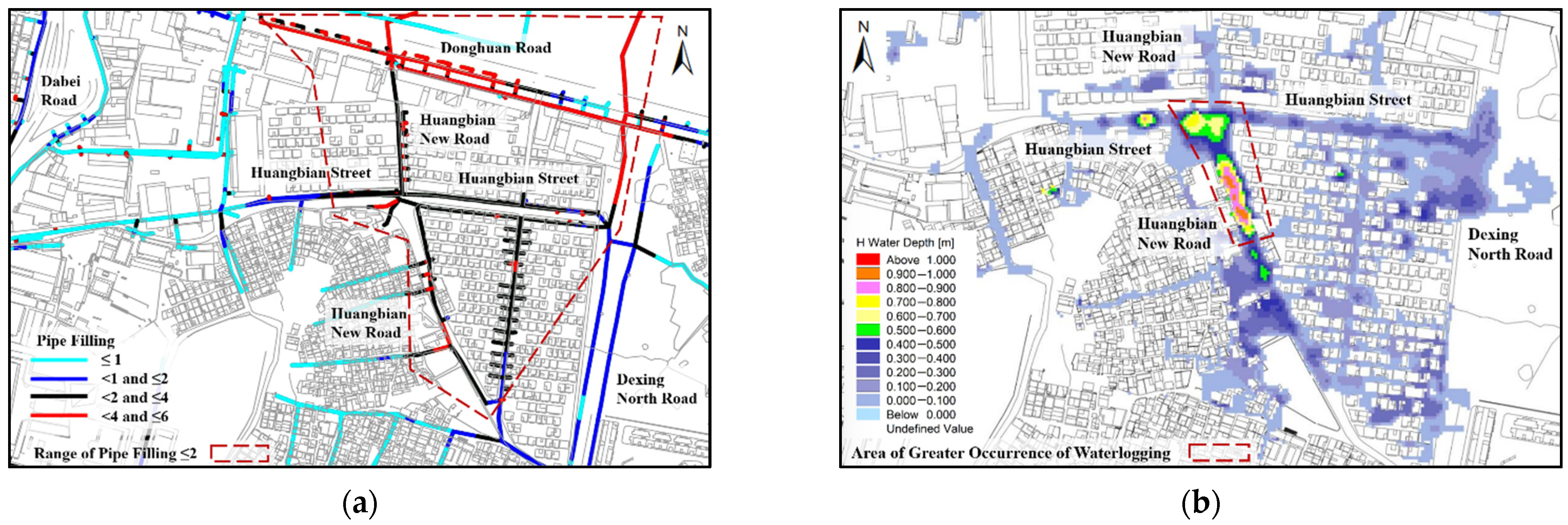
Figure 3 shows simulated results of the degree of fullness of the pipe network and waterlogging situations in the study area. As Figure 3a shows, pipes of Huangbian New Road, Huangbian Street, and Donghuan Road have a high degree of fullness and a poor discharging capacity and hence are susceptible to waterlogging disasters. The simulation indicates that the major waterlogged sites include the intersection between Huangbian New Road and Huangbian Street, as well as the low-lying area that is 70 m south of Huangbian New Road: the area of waterlogged regions with a depth of water of 0.15 reaches 2.06 hm2, and the maximum inundation depth is 0.95 m.

Figure 3.
Simulation of waterlogging under designed rainfall conditions. (a) Degree of fullness of the pipe network (Pipe filling: The pipe filling is calculated as the depth divided by the pipe height, e.g., if the pipe is running under pressure the ratio will be above 1.0.); (b) Distribution of inundation depths.
4.1.1. Deployment of Runoff Production Reduction Facilities
Low-impact development (LID) measures are taken to reduce runoff and flood discharge, which are the major methods that control waterlogging from the source. Due to the shortage of useable land in the city, it is largely infeasible to adopt LID measures on a large scale. In the present work, the impermeability of both the upstream of the waterlogged spot and a region adjacent to the waterlogging region with an equal area is reduced by 15%, and the effect is assessed. Specifically, in Scheme 1, the impermeability of the water catchment with an area of 22 hm2 north of the upstream of the waterlogged site was reduced by 15%; in Scheme 2, the impermeability of a water-catchment area of 22 hm2 near the waterlogged spot was reduced by 15%. Figure 4 shows the schematics of Schemes 1 and 2.
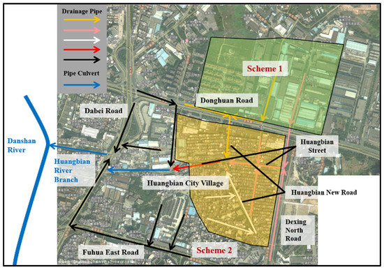
Figure 4.
Schematics for Schemes 1 and 2 of impermeability reduction.
4.1.2. Allocation of Storage Tanks
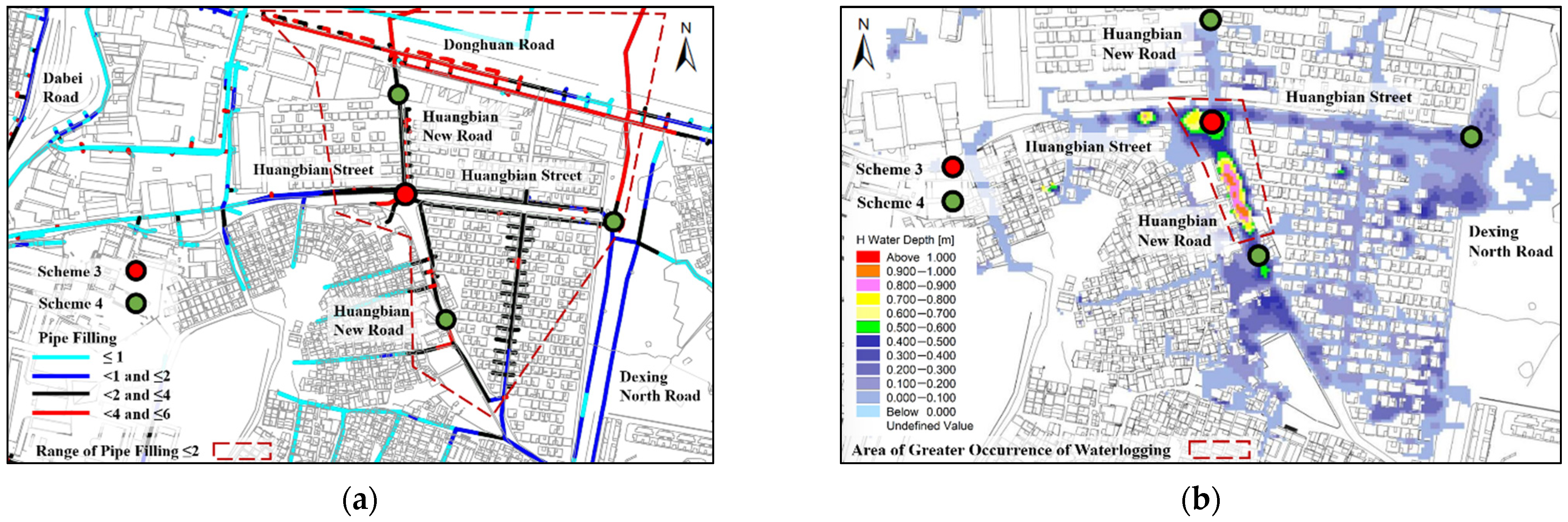
Stormwater tanks can be used to increase the carrying capacity of the stormwater discharge system, hence cutting the flood peak and reducing the flow of downstream pipes and the water level of the pipe network. According to the drainage capacity of the pipe network and the distribution of low-lying regions susceptible to waterlogging in the study area, two different deployment schemes of stormwater storage tanks—decentralized and centralized schemes—were simulated and assessed. Scheme 3 is the centralized deployment scheme: one stormwater storage tank was deployed at the drainage bottleneck of the middle and lower section of the pipe network in the waterlogged site, the volume was set at 1500 m3 as per the deprivation coefficient method [17], and it was a water reception tank. Scheme 4 is a decentralized scheme: three stormwater storage tanks were deployed in the middle and upper sections of the drainage pipe network, which are within the northern, eastern, and southern catchment areas upstream of the waterlogged site; the volume of the three tanks was set at 300 m3, 650 m3, and 250 m3, respectively, totaling 1200 m3. Figure 5 shows the relations between the location of stormwater storage tanks, the location of drainage bottlenecks of the pipe network, and the waterlogged site in Schemes 3 and 4.
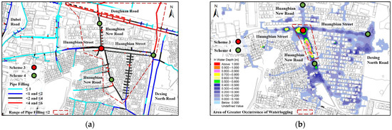
Figure 5.
Deployment of stormwater tanks in Schemes 3 and 4. (a) Degree of fullness of the pipe network and deployment of stormwater storage tanks; (b) The waterlogged area and the deployment of stormwater storage tanks.
4.1.3. Water Level Control of River Channels
As cities on a plain feature a flat terrain, the water level of river channels has a significant jacking effect on the drainage pipe network. In the present work, the water level of the drainage pipe outlet was reduced by 0.25 m (Scheme 5) and 0.5 m (Scheme 6) to assess their respective effect on waterlogging.
4.2. Effect Assessment
4.2.1. Effect of Optimized Deployment of Runoff Production Reduction Facilities
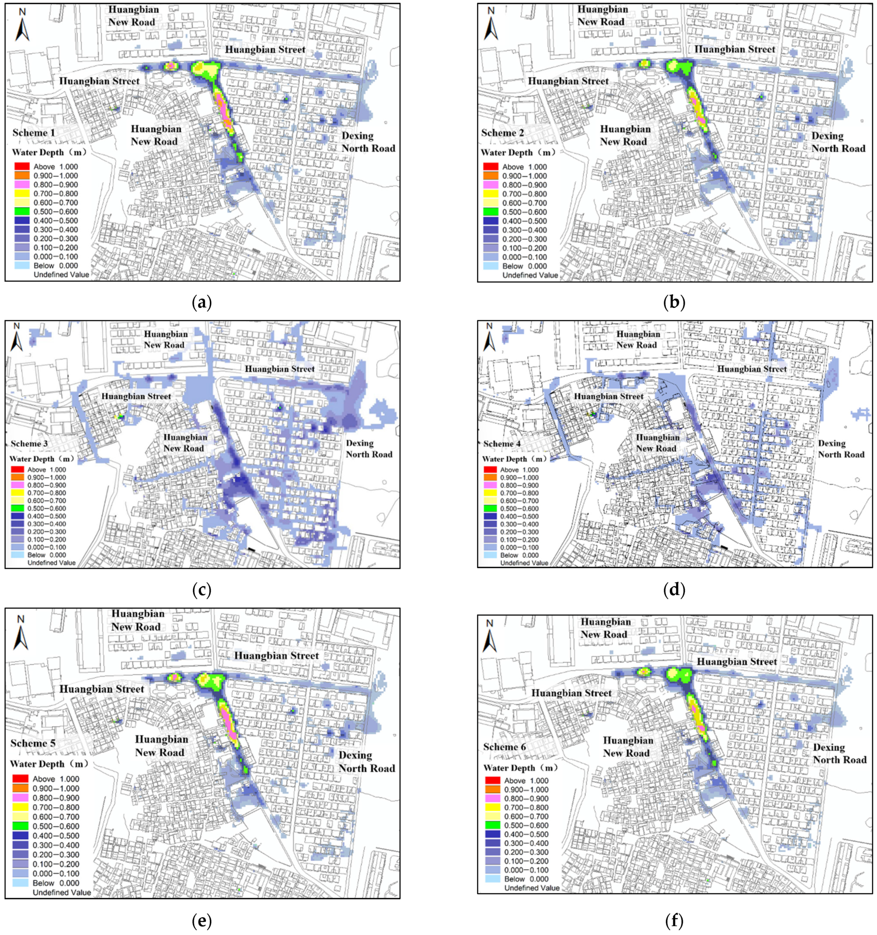
In Scheme 1, the waterlogged area with an inundation depth larger than 0.15 m was reduced to 1.98 hm2 (a drop of 4%), and the maximum inundation depth was reduced by 2% to 0.93 m. Scheme 2 reduced the waterlogged area by 16% to 1.69 hm2 and cut the maximum inundation depth by 13% to 0.93 m. To sum up, Scheme 2, which reduces the permeability of regions of drainage bottleneck of the pipe network near the waterlogged site, achieves a better effect than Scheme 1. Figure 6a,b and Table 2 show the simulation results of Schemes 1 and 2 under designed rainfall conditions.
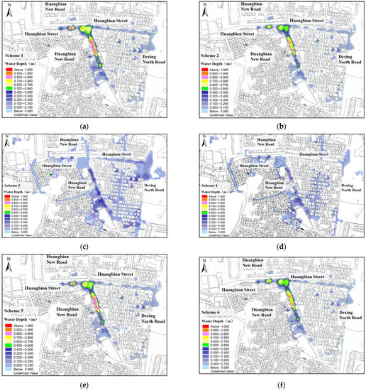
Figure 6.
Schematics of different schemes against waterlogging under designed rainfall conditions. (a) Scheme 1; (b) Scheme 2; (c) Scheme 3; (d) Scheme 4; (e) Scheme 5; (f) Scheme 6.
Table 2.
Simulation statistics of different schemes against waterlogging under designed rainfall conditions.
4.2.2. Effect of Optimized Deployment of Stormwater Storage Tanks
Scheme 3, in which the one tank was deployed at the waterlogging site, reduced the area of the waterlogged region with an inundation depth larger than 0.15 m by 46% to 1.11 hm2 and cut the maximum inundation depth by 53% to 0.45 m. Scheme 4, in which three tanks were deployed in a decentralized manner upstream of the waterlogged site, reduced the waterlogged area to 0.39 hm2 (a decrease of 81%) and cut the maximum inundation depth by 66% to 0.32 m. Thus, Scheme 4 outperforms Scheme 3. Moreover, Scheme 4 not only alleviated the waterlogging problem but reduced the volume of the tank by 300 m3, with the volume of single tanks less than 50% of the centralized tank in Scheme 3, making it a more practical solution for the urban regions short of useable land. Figure 6c,d and Table 2 show the simulation results of the effect of Schemes 3 and 4 against waterlogging under designed rainfall conditions.
4.2.3. Effect of Water-Level Control of River Channels
Scheme 5 reduced the area of the waterlogged region with an inundation depth larger than 0.15 m by 9% to 1.84 hm2, and the maximum inundation depth was decreased by 6% to 0.89 m; Scheme 6 reduced the area of the waterlogged region to 1.70 hm2 (a drop of 16%) and the maximum inundation depth to 0.84 m (a drop of 12%). In the case of submerged discharge, a larger decrease in the water level of the outlet of the downstream pipes led to better effects on alleviation of waterlogging. Figure 6e,f and Table 2 show the simulation of Schemes 5 and 6 against waterlogging under designed rainfall conditions.
4.3. Summary
As Table 2 and Figure 6 suggest, Schemes 2, 4, and 6 outperform their alternatives (Schemes 1, 3, and 5) in alleviating the problem of urban waterlogging. Among the three groups of measures, the second group, i.e., optimized deployment of stormwater storage facilities, achieved better effects against waterlogging than the other two groups that reduced the impermeability or decreased the downstream water level.
To sum up, if the measure of reducing runoff production is adopted to alleviate waterlogging, the impermeability of a large area of land will need to be reduced to achieve effective control of waterlogging. If stormwater storage facilities are used to curb waterlogging, decentralized deployment of stormwater tanks is preferable to decentralized deployment. In the case of submerged discharge, reducing the water level of the downstream pipe network is also an effective measure against waterlogging, but it entails stronger flood discharge capacities of the downstream drainage system.
5. Effects of Comprehensive Schemes of Combined Measures
Based on analysis of the optimized schemes of infiltration, storage, and drainage measures, and according to the principles of reduction of discharge at the source, process control, and systematic management of waterlogging, comprehensive schemes were proposed to explore the effects of combined measures.
5.1. Scheme Design
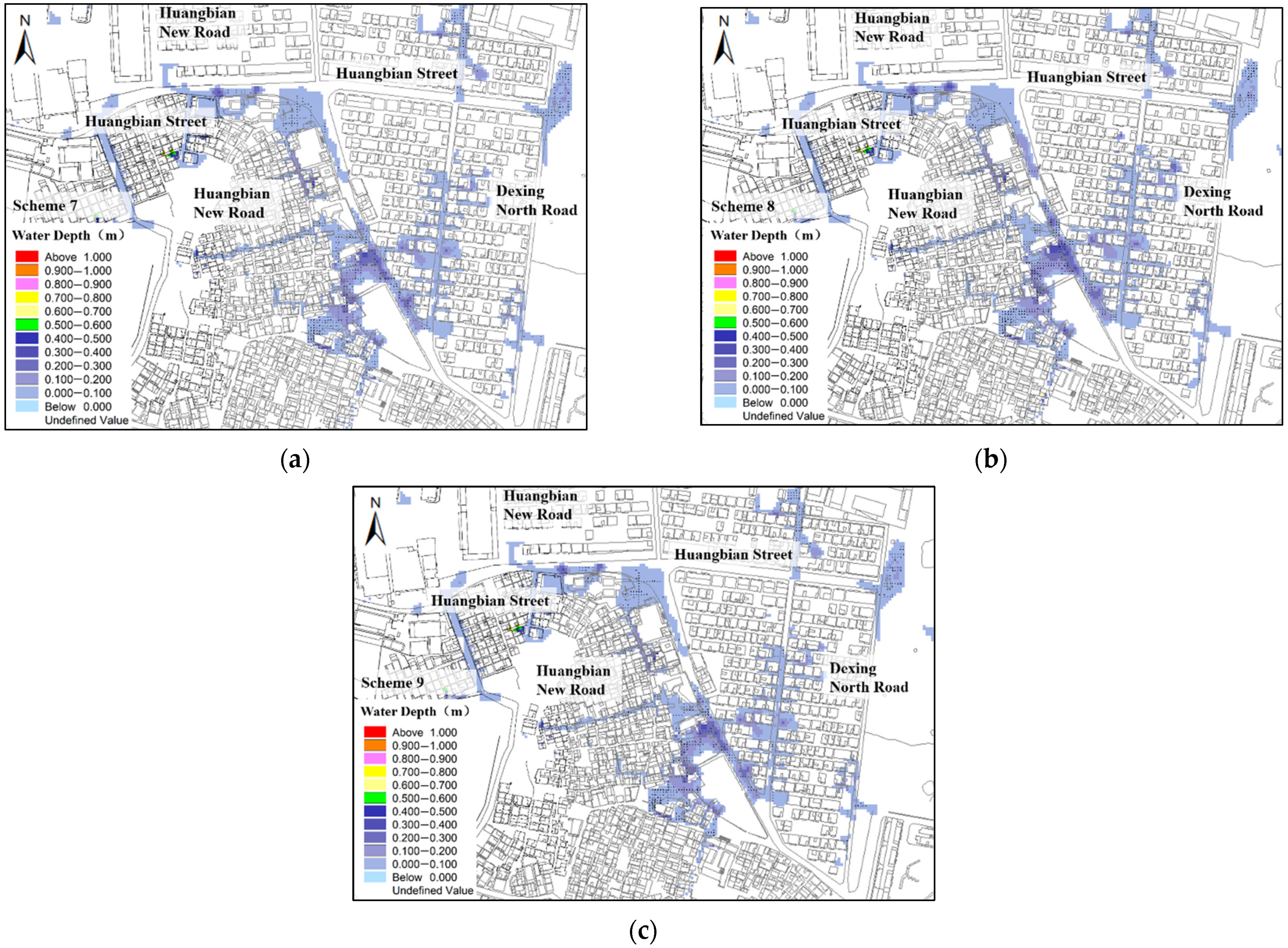
As indicated from analyses of single-measure schemes, the scheme of decentralized deployment of stormwater tanks achieved the best performance. Therefore, in the comprehensive scheme, it was combined with the measures of “infiltration” and “drainage”. Specifically, three comprehensive schemes were designed. In Scheme 7, stormwater storage tanks of 1200 m3 were deployed in a decentralized manner, and the impermeability of the water catchment region of 22 hm2 near the waterlogged site was reduced by 15%; in Scheme 8, stormwater tanks of 1200 m3 were deployed in a decentralized manner, and the water level of the outlet of the pipe network was reduced by 0.50 m; for Scheme 9, stormwater tanks of 1200 m3 were deployed in a decentralized manner, the impermeability of a catchment region of 22 hm2 near the waterlogging site was reduced by 15%, and the water level of the outlet of the pipe network was reduced by 0.50 m.
5.2. Analysis of Effects of Comprehensive Schemes
As the simulation (Table 3, Figure 7) shows, Scheme 7 reduced the area of the waterlogged region to 0.26 hm2 (a drop of 87%) and the maximum inundation depth to 0.31 m (a drop of 67%), which improved the effect of Scheme 7 by 6% and 1%, respectively. Scheme 8 reduced the area of waterlogged regions to 0.35 hm2 (a drop of 83%) and the maximum inundation depth to 0.31 m (a drop of 67%), which are 2% and 1% better than Scheme 7. Scheme 9 reduced the area of waterlogged regions to 0.35 hm2 (a drop of 88%) and the maximum inundation depth to 0.29 m (a drop of 69%), reductions that are 7% and 3% larger than those achieved by Scheme 7. In sum, schemes of combined measures had significantly better performance than single-measure schemes, among which schemes that combined “storage” and “infiltration” measures performed the best, and the stormwater storage facilities contributed the most to the alleviation of waterlogging. “Infiltration” and “storage” are crucial measures against waterlogging, and to address the problem of waterlogging in cities on plain river network regions, we need to construct a “storage-drainage combined” waterlogging control system on the basis of the original “drainage-dominated” regime, coupled with LID measures that control runoff production.
Table 3.
Simulation statistics of different schemes against waterlogging under designed rainfall conditions.
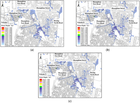
Figure 7.
Simulation results of comprehensive schemes under designed rainfall conditions. (a) Scheme 7; (b) Scheme 8; (c) Scheme 9.
6. Conclusions
Frequent outbursts of urban waterlogging disasters have drawn wide attention from urban administrations, making it a priority of government work to find solutions to waterlogging and maximize their effects. In the present work, coupling models were used to explore the effects of different schemes of “infiltration”, “storage”, and “drainage” measures against waterlogging. The major findings are as follows.
- (1)
- Reducing the impermeability of regions near the waterlogged site, decentralized deployment of stormwater tanks upstream of the waterlogged site, and reducing the water level of the river channel are the better options for infiltration, storage, and drainage measures, which achieve better effects on waterlogging alleviation than their respective alternatives.
- (2)
- Among these three types of measures, the “storage” measure that relies on stormwater storage facilities reached the best effect against waterlogging, whereas the other two, which reduced the impermeability or the downstream water level of the pipe network, played a relatively limited role.
- (3)
- Comprehensive schemes of combined measures had significantly better performance than single-measure schemes, where schemes that combine “storage” and “infiltration” measures achieved the best effects, and stormwater storage facilities contributed the most to the alleviation of waterlogging.
- (4)
- “Storage” and “infiltration” are crucial measures against waterlogging, and in future initiatives to alleviate waterlogging disasters in cities in plain river network regions, it is necessary to construct a storage-drainage combined stormwater management system on the basis of the original drainage-dominated regime, and introduce the low-impact development measures that control runoff production.
Generally speaking, making full use of the green land, open space, and low-lying area to build storage facilities and increase the regional storage capacity are the most cost-effective solutions for urban waterlogging in plain river network areas. For regions without space to build storage facilities, the cost-effectiveness of alternatives needs to be analyzed in accordance with the real situation.
Waterlogging prevention and alleviation are systematic engineering initiatives. Under the guidelines of reducing discharge at the source, process control, and systematic management in waterlogging control, we need to combine multiple measures including infiltration, retention, storage, purification, use, and drainage to create a virtuous cycle of urban water resources, and improve the capacity of urban pipe networks for infiltration, regulation, storage, purification, use, and drainage of stormwater.
Author Contributions
Conceptualization, P.L. and Q.W.; methodology, Q.W.; software, Q.W.; validation, P.L. and Q.W.; formal analysis, Q.W., Z.L. and W.L.; investigation, Q.W.; resources, P.L.; data curation, Q.W., Z.L. and W.L.; writing—original draft preparation, Q.W.; writing—review and editing, P.L. and Q.W.; visualization, Q.W.; supervision, P.L.; project administration, P.L.; funding acquisition, W.L. All authors have read and agreed to the published version of the manuscript.
Funding
This research was funded by Guangzhou Tianhe Information Technology Bureau, grant number 201904010335.
Institutional Review Board Statement
Not applicable.
Informed Consent Statement
Not applicable.
Data Availability Statement
The study did not report any data.
Conflicts of Interest
The authors declare no conflict of interest.
References
- Nie, J. Research on Comprehensive Evaluation of Waterlogging Risk in Urban River Network Dense Area. Water Resour. Plan. Des. 2020, 11, 21–23, 80. [Google Scholar]
- Hu, T. The Research of Rainwater Facility Model of the Concept of Low Impact Development. Ph.D. Thesis, South China University of Technology, Guangzhou, China, 2018. [Google Scholar]
- Yang, Y.; Xiao, B.; Cui, H.; Huang, M.; Zou, Y.; He, Y.; Cao, C. Development history of sponge cities and the state of research on runoff pollution control. J. East China Norm. Univ. (Nat. Sci.) 2018, 6, 32–42. [Google Scholar]
- Liu, J.; Li, Y.; Zhang, X.; Chen, H. Research on the Urban Storm Control Effect of Different LID Measures Based on SWMM. China Rural Water Hydropower 2020, 7, 6–11. [Google Scholar]
- Firoozabadi, P.E.; Nazif, S.; Hosseini, S.A.; Yazdi, J. Developing an algorithm for urban flood management with the aim of reducing damage and costs using the concept of conditional value at risk. Stoch. Environ. Res. Risk Assess. 2022, 36, 353–371. [Google Scholar] [CrossRef]
- Cristiano, E.; Farris, S.; Deidda, R.; Viola, F. Comparison of blue-green solutions for urban flood mitigation: A multi-city large-scale analysis. PLoS ONE 2021, 16, e0246429. [Google Scholar] [CrossRef] [PubMed]
- Meng, Y. Effect of Low Impact Development Measures on Inundation Reduction—Taking Jinan Pilot Area as Example. Ph.D. Thesis, China Institute of Water Resources and Hydropower Research, Beijing, China, 2019. [Google Scholar]
- Fei, M. Research on Countermeasures and Implementation Paths of Pluvial Flooding in the Perspective of Spongy City: Taking Shanghai as Example. Ph.D. Thesis, East China Normal University, Shanghai, China, 2018. [Google Scholar]
- Jiao, S.; Hu, X.; Han, Z. A Study on Quantitative Evaluation of Effect Factors of Urban Waterlogging under Multiple Scales: Taking Five Internal Zones in Changsha as an Example. Ecol. Econ. 2020, 36, 222–229. [Google Scholar]
- Liao, C.; Cai, Y.; Huang, W.; Cheng, M. Hydrology and storage capacity analysis of rainwater retarding practices for flood mitigation in urban area. Adv. Water Sci. 2006, 17, 538–542. [Google Scholar]
- Wu, X.; Zhou, Y.; Yang, H.; Lou, F.; Liu, Y.; Liu, Z. Research on Methodology of Distributing Rainwater Storage Units. China Water Wastewater 2017, 33, 114–118. [Google Scholar]
- Jemberie, M.A.; Melesse, A.M. Urban Flood Management through Urban Land Use Optimization Using LID Techniques, City of Addis Ababa, Ethiopia. Water 2021, 13, 1721. [Google Scholar] [CrossRef]
- Deng, J.; Liu, C.; Gao, H.; Ma, C.; Cui, X. Effect of Drainage System Construction on Urban Flood Disaster. J. Yangtze River Sci. Res. Inst. 2020, 37, 51–56. [Google Scholar]
- Yan, X.; Xu, K.; Feng, W.; Chen, J. A rapid prediction model of urban flood inundation in a high-risk area coupling machine learning and numerical simulation approaches. Int. J. Disaster Risk Sci. 2021, 12, 903–918. [Google Scholar] [CrossRef]
- Li, T.; Lee, G.; Kim, G. Case Study of Urban Flood Inundation—Impact of Temporal Variability in Rainfall Events. Water 2021, 13, 3438. [Google Scholar] [CrossRef]
- Dreelin, E.A.; Fowler, L.; Carroll, C.R. Test of porous pavement effectiveness on clay soils during natural storm events. Water Res. 2006, 40, 799–805. [Google Scholar] [CrossRef] [PubMed]
- Fu, X.; Liu, J.; Zhou, G.; Mei, C.; Wang, H.; Zhang, F.; Sun, P.; Zhong, H. Waterlogging control-oriented design of capacity of underground rainwater storage pool. Water Resour. Hydropower Eng. 2019, 50, 1–8. [Google Scholar]


Publisher’s Note: MDPI stays neutral with regard to jurisdictional claims in published maps and institutional affiliations. |
© 2022 by the authors. Licensee MDPI, Basel, Switzerland. This article is an open access article distributed under the terms and conditions of the Creative Commons Attribution (CC BY) license (https://creativecommons.org/licenses/by/4.0/).