Review

Review of Isotope Hydrology Investigations on Aquifers of Cameroon (Central Africa): What Information for the Sustainable Management of Groundwater Resources?

by
Bertil Nlend
1,
Frederic Huneau
2,3,*,
Suzanne Ngo Boum-Nkot
1,
Fricelle Song
1,
David Komba
1,
Bernard Gwodog
1,
Parfait Meyoupe
1,
Boris Djieugoue
1 and
Enoh Fongoh
4
1
Faculty of Sciences, University of Douala, Douala P.O. Box 24157, Cameroon
2
Département d’Hydrogéologie, Université de Corse Pascal Paoli, Campus Grimaldi, BP 52, F-20250 Corte, France
3
CNRS, UMR 6134 SPE, BP 52, F-20250 Corte, France
4
Water and Climate Change Research Centre, Institute of Geological and Mining Research, Yaoundé P.O. Box 4110, Cameroon
*
Author to whom correspondence should be addressed.
Water 2023, 15(23), 4056; https://doi.org/10.3390/w15234056
Submission received: 6 October 2023 / Revised: 3 November 2023 / Accepted: 14 November 2023 / Published: 22 November 2023
(This article belongs to the Special Issue The Use of Environmental Isotopes in Hydrogeology)

Abstract

:
In Central Africa, groundwater remains the least understood component of the water cycle. Isotopic techniques that are well known to be efficient in tracking the movement of water along its path have been applied for only three decades and can be summarized in a handful of case studies. This review aims to put together all the stable and radioactive isotopic data (>500 samples from rainfall, surface and groundwater) published in Cameroon to: (i) identify the drivers responsible for precipitation isotopes’ spatial variation and climatological implications, (ii) elucidate the groundwater recharge mechanisms over the countries and relationships with rivers, and (iii) highlight the existence of paleo-groundwater in the country. It is found that rainfall stable isotope variation is linked to the migration of the Intertropical Convergence Zone (ITCZ): the groundwater recharge can be diffuse and focused. This latter mechanism is mainly observed in the semi-arid region. It is in this relatively dry region that most of the paleo-groundwater resources are identified thanks to 14C dating. This information will be useful to develop water management strategies regarding all the challenges (e.g., climatic and demographic) faced by the country. Finally, this paper discusses the gaps groundwater isotope hydrology can still fill for contributing to a sustainable development of the country.

1. Introduction

The usefulness of isotope techniques in hydrological investigations stems from their ability to label water sources and understand cycling processes, including surface–groundwater interaction, water residence times, flow pathways, evaporation fluxes, and solute processes, to name a few [1]. Stable isotopes (18O and 2H), incorporated within the water molecule undergoing measurable systematic fractionations as they move between phases in the water cycle are efficient, and therefore the best tracers to study the connections between the different compartments of the hydrosphere and even their link with the atmosphere and biosphere [2], which form part of a global hydrological cycle. Moreover, nowadays, isotope hydrologists have been investigating the processes controlling water quality [3]. Water-related biogeochemical studies have also tended to rely extensively on solute isotopes, namely, carbon, nitrogen, strontium, sulfur, and chloride [4].
However, while widespread in temperate and high-latitude areas, application of isotope tracer techniques in intertropical zone is still minimal, especially in Central Africa [5], yet this region represents a dynamic environment marked by strong climate variability associated with convective events [6] and a high population growth rate [7]. It is worthwhile noting that no part of the planet is urbanizing faster than sub-Saharan Africa. The urban population, estimated at 472 million in 2020, is predicted to double by 2040 [7]. The impact that humans are having in this region on the water cycle is indisputable in terms of water budgets, acceleration of water fluxes [8] and water quality deterioration [9]. In this context of global changes, it is clear that isotopic tools can provide reliable information about the quality and the quantity of water resources. Of particular concern are groundwaters, which are the most exploited for drinking, agricultural and various activities over the continent, with a great role in the maintenance of surface ecosystems [10]. This interest for groundwater has grown in the context of climate change, the increasing demand for water, especially in urban areas, and changing consumption patterns [11]. In the same way, the use of stable and radioactive isotopes, efficient tools that can also be less expensive than other hydrogeological methods, has increased. These advances are partly attributed to the development of laser spectroscopic techniques.
This article presents a review of Cameroonian progress in isotope hydrology in this country considered as the “little Africa” due to its hydroclimatic and cultural diversity [12]. The first isotopic investigations there date back approximately 30 years with projects supported mainly by the International Atomic Energy Agency (IAEA). Indeed, following the droughts of the 1970s and 1980s, vast groundwater exploitation programs were undertaken throughout the Sahelian fringe of Cameroon. Comprehensive studies taking into account all aspects of hydrology and hydrogeology were therefore carried out. Then, isotope techniques were deployed in the beginning of 2000s in humid territories of the country, thus increasing substantially the national spatial coverage of isotope data [13].
This review includes a complete historical description of contributions including precipitation networks, monitoring network of rivers, groundwater studies and propositions concerning future investigations for the development of isotope techniques in the study region. This will be the first synthesis of and a comprehensive research on the use of environmental isotopes (δ18O, δ2H, 3H, 14C and 13C) in hydrogeology in a sub-Saharan African country. By providing insights on controls of spatial variation of precipitation isotopes, groundwater recharge mechanisms and identification of paleo-groundwater, the paper will contribute to advancing our understanding of the groundwater characteristics of Cameroon, which can be used as a basis for future investigations.

2. Study Site Description

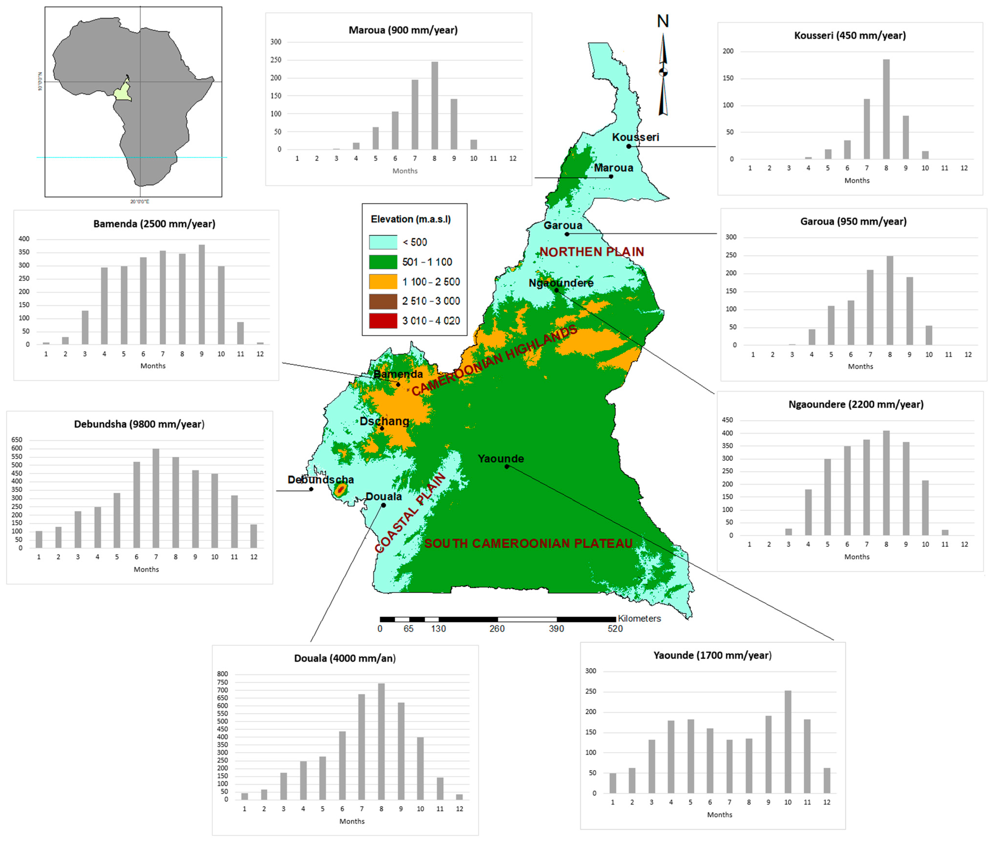
2.1. Strong Hydroclimatic Diversity

Cameroon is a country located in Central Africa with an area of 475,000 km2 (Figure 1). Its topography is characterized by low-lying areas (<500 masl) in the northern and southwestern parts, which are surrounded by highlands (500–1500 masl) and mountains (>1500 masl), representing almost a quarter of the country. The littoral plain follows the shape of the coast and isolates Mount Cameroon (4100 masl). The northern plains are subdivided by the Bénoué basin in the region of Garoua (southern part) and the Lake Chad plain (northern part). Mountains extend from Mount Cameroon to the Central African Republic over a length of nearly 400 km from southwest to northwest. This geomorphological domain is commonly called the Cameroonian ridge. The altitudes culminate at 2000–3000 masl in the central part. South of the ridge, there are some modest peaks, then important domes such as Mount Koupé and the Manegoumba mountains—2064 and 2411 m, respectively. The plain follows this arrangement of reliefs and establishes the link with the highlands in the western part of the country. The plateaus are divided into two: the Adamaoua plateau in the region of Ngaounderé and the southern Cameroon plateau (Figure 1). The Adamaoua plateau dominates the Bénoué basin via a series of cliffs. In the southern Cameroonian plateau, the relief has many disparities, with altitudes reaching 1585 masl in the north of the area.
This geomorphological complexity of Cameroon leads to different climatic units, as follows.
(i)
The Guinean equatorial climate in the southern Cameroonian plateau with annual rainfall ranging between 1500 and 2000 mm and an annual mean temperature of 25 °C. The rainiest months correspond to March–April and September and the driest months are December–January and July–August.
(ii)
The equatorial maritime climate type extends from the southern coast and covers part of the western high plateau. The annual rainfall ranges from 2000 to 10,000 mm, being especially high where Cameroon’s volcanic massif comes close to the coast. Debundscha, with nearly 10,000 mm of rainfall per year, is the second-rainiest place on Earth after Chirapunji in India [12]. In this type, the nearness to the coast and the effect of the altitude on the southwest monsoon are responsible for the heavy annual rainfall [14]. The amount of rainfall decreases from the coastal areas towards the interior highlands, as shown by the data for Limbe (4000 mm) in the southeast of Mount Cameroon, Dschang (3000 mm) and Bamenda (2000 mm) in the western regions. Here, the rainfall distribution is unimodal, with the rainiest period from June to August. The average annual temperature for high altitudes is about 21 °C, while for low-lying coast, the annual average temperatures climb to 25.5 °C.
(iii)
Rainfall decreases northwards and the Sudan climate extends from the Adamawa Plateau to the 900 mm isohyet in the northern regions. Rainfall is spread just over four or five months, while the other months are dry. The mean annual temperature is about 28 °C.
(iv)
The Sudano-Sahelian type is the northernmost climatic type, extending from Maroua to the far-north border. It is characterized by a short rainy season and a marked dry season. Here, the rainfall ranges from 900 mm around Maroua to 500 mm around Kousseri, and 400 mm around the shores of Lake Chad. The mean annual temperatures are similar to those of the Sudan type, but the thermal amplitude is relatively high in comparison [14].

2.2. A Complex Geology and a Still-Underdocumented Hydrogeology

2.2.1. Geology

Cameroon is underlaid by Precambrian rocks, Cretaceous sediments and Cenozoic sedimentary and volcanic formations (Figure 2). The basement rocks can be divided into two stratigraphic units:
-
the Congo Craton (Archean age) in the south, made mainly of gneiss, granite and charnockite [15];
-
the Central African Mobile Zone (CAMZ; Pan-African age) in the north, which consist of remobilized Precambrian terrain including igneous and metamorphic rocks. The main rock types here are mica schists, micaceous gneisses, and migmatites intruded by quartz, diorite and granodiorites.
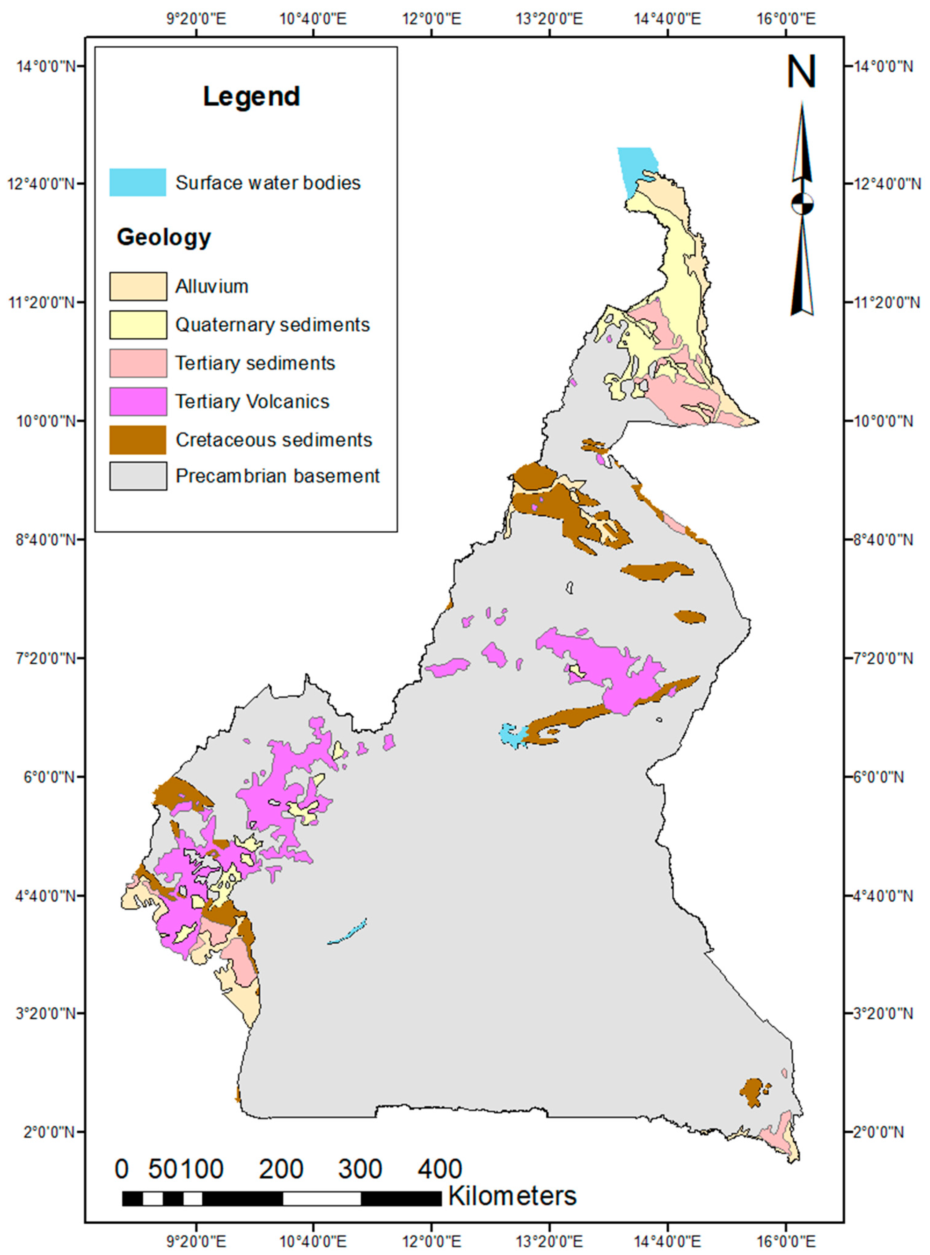
The basement is overlaid in some places by Lower Paleozoic volcanic and younger sedimentary formations [16].
Cenozoic magmatic rock types in Cameroon can be divided into two major units. Ring complexes range in diameter from 1 to 10 km and are often associated with the Cameroon Volcanic Line (CVL), comprising a variety of rock types including syenites and granites. The ring complexes probably represent deeply eroded remnants of older volcanoes that were intruded into the granitic and metamorphic Precambrian Basement and into early Tertiary sediments. It extends over a distance of about 1000 km parallel to the NE–SW alignment of the CVL. This latter is characterized by a 1600 km-long Y-shaped chain of Tertiary to recent generally alkaline volcanoes that stretch from the Atlantic island of Pagalu through the Gulf of Guinea into the interior of western Africa. Sub-recent volcanic activity shows lava generally evolving from mildly alkaline basalts towards trachyte and rhyolite.
Sedimentary rocks are restricted to the southwestern and northern parts of the country (Figure 2). In northern Cameroon, the sedimentary facies of the Cretaceous is mainly continental, while the Cretaceous in the coastal area is mainly marine. In the south, the Douala and Rio del Rey offshore basins are typical passive margin basins that originated during the opening of the equatorial Atlantic Ocean [17]. They formed one continuous sedimentary basin that stretched from Nigeria to southern Cameroon from Cretaceous (lying uncomfortably on the crystalline basement) to Quaternary. The Lake Chad Basin, the main sedimentary basin within the country, in the north is covered by Miocene to modern sediments. Alluvial and colluvial materials of the Holocene age predominate in the floodplains of the large rivers Logone and Chari [18].
Figure 2. Simplified geological map of Cameroon (modified from [18]).
Water 15 04056 g002

2.2.2. Hydrogeology

This section presents the main aquifers in Cameroon. Three major groups are identified: basement aquifers, volcanic aquifers and unconsolidated sedimentary aquifers.

Basement Aquifers

Since Precambrian rocks occupy the majority of the territory (Figure 1), basement aquifers are the most common in Cameroon, with a productivity ranging from low to high. Rocks are sometimes covered with alluvium or other unconsolidated deposits and laterite. These aquifers are generally found at local scale, limited to areas where the rock has been fractured and weathered. The combined thickness of laterite and weathered basement is usually between 8 and ~30 m [18]. Below this, there can be a deeper fractured aquifer, which usually has low permeability. The best yields are found where fractured rocks are overlaid with a thick weathered zone or thick alluvium. The water table can reach 20 m. Borehole yields are usually ~1 to 5 m3/h, but can rarely reach 30 m3/h (in the southern region), associated with large faults [19]. The aquifers are drained by rivers and springs at low elevation, which is typical in hard rock areas where groundwater watersheds are similar to surface watersheds [20]. The groundwater flow directions are in conformity with the major lineaments of hydrogeological importance [21].

Volcanic Aquifers

Aquifers from volcanic rocks of various ages are mainly located in the southwest part of the country. Pyroclastic cones are underlaid by impermeable layers of basalts. The jointed nature of some of the basaltic lava flows and the porous nature of the scoriaceous deposits make this area a large hydrological reservoir. Due to the fact that tectonics associated with volcanism create fracturing and faulting that runs over long distances, the formations of the low-lying piedmonts beside the volcanic relief have deep joints, fractures, and faults, and because of their abundance and connectivity can retain large volumes of running water in underground channels that surge out downslope as large springs (some of them are thermal). The jointed and fractured nature of the basalts together with the unwedded nature of the pyroclastic deposits gives the underlying substratum a high porosity and permeability.

Unconsolidated Aquifers

These refer to alluvium, marine and estuarine deposits. Aquifers are found in three major basins: the Douala sedimentary basin (SW of the country), the Garoua basin (northern part of the country) and the Lake Chad basin in the far north (Figure 2). For the Douala sedimentary basin, the main groundwater resource is formed from Mio-Plio-Quaternary sands, which form a complex multilayer aquifer with a clay layer intercalated. The maximum aquifer thickness is about 220 m [22] with an average hydraulic conductivity of 1.5 × 10³ m/s and a mean of transmissivity corresponding to 5 × 10³ m2/s [22]. The deeper Cretaceous sandstones is the second important aquifer of this basin, with a thickness exceeding 100 m, a yield of more than 10 m3/h and a transmissivity of about 2 × 10⁴ m2/s [22]. The Garoua basin is characterized by sandstones representing a highly productive aquifer, with hydraulic conductivity of around 2.22 × 10³ to 2.2 × 10⁻² m/s, transmissivities of 8.33 × 10⁻² to 0.47, and a storage coefficient of 0.025. Boreholes are typically between 40 and 200 m deep [23]. The Lake Chad basin aquifer contains two main aquifer units: the Tertiary Continental Terminal and the Quaternary aquifer. The Continental Terminal is made of sandstones (200 m thick on average), covered by sands from lower Pliocene and then by clays from Upper Pliocene (200–300 m). It can appear as an artesian aquifer in some areas of the basin. The Quaternary aquifer (50 to 100 m of thickness) is the main transboundary regional aquifer, characterized by different deposits characterizing the sedimentation phases around the lake. This aquifer is confined or semiconfined depending on the relative position and the occurrence of clay layers. Past investigations on this aquifer revealed moderate to high productivity with for instance transmissivity values ranging from 1 × 10⁻² to 7 × 10⁻² m2/s [24]. Generally, the groundwater flow follows the topographic scheme with groundwater drained by rivers [24]. However, a recharge of groundwater from surface water has been also recorded in the Lake Chad basin [24]. Geological cross sections of the main investigated sedimentary basins are shared in Supplementary Materials, as well as a geological cross section representing the basement.
In all these contexts, groundwater is exploited through springs, hand-dug wells and private boreholes. It is worthwhile noting that during the last few decades, there has been a remarkable increase in the construction of private boreholes and hand-dug wells to meet the growing demand. This is due to the fact that public services are often failing [9,18].

3. Datasets, Methods and Analysis

It is worthwhile noting that development and application of isotopic techniques in Cameroon are being done through national and international projects supported by the International Atomic Energy Agency (IAEA).
The first project (RAF/8/012-Isotope hydrology in Sahelian countries) took place in the Sahel, thus covering far-north Cameroon [13,24,25]. Indeed, following the droughts of the 1970s and 1980s, vast groundwater exploitation programs have been undertaken throughout the Sahelian fringe [25]. Therefore, it has been necessary to implement, in parallel, comprehensive studies taking into account all aspects of hydrology and hydrogeology in order to achieve the development of management models based on the most complete possible knowledge of aquifers characteristics. Thanks to this project, for the first time, researchers from sub-Saharan Africa started to use isotopic and nuclear techniques in hydrology and hydrogeology. Beatrice Ketchemen-Tandia among these researchers studied the hydrogeological functioning of aquifers with emphasis on the use of isotopes to determine groundwater recharge mechanisms [13,24,25]. The Douala region subsequently became the center of investigations (with CMR/8/005, CMR/8/008 and RAF 7/021 projects). This was encouraged by the fact that while widespread in temperate and high-latitude areas, applications of isotope tracer techniques in humid tropics remain minimal and especially in Africa. Isotopic studies in Douala have so far focused on the characterization of precipitation isotopes related to convective events and groundwater recharge conditions under high rainfall rates. Though mainly focused in the Sahelian (far north) and the humid (Douala) parts of the country, for instance, with long-term monitoring of precipitation and rivers thanks to GNIP (Global Network of Isotopes in Precipitation) and GNIR (Global Network of Isotopes in Rivers) stations [26], the use of isotopes techniques has become more widespread and studies have been performed in different places in the country.
Data (stable and radioactive isotopes) used in this paper were collected mainly from published articles and public reports. Given the various sources, priority was given to data from scientific articles and technical reports (Table 1). We then compiled data from each case study throughout the country, followed by statistical processing and analysis in terms of geomorphoclimatic controls. Thus, in addition to isotopic data from groundwater and rivers, meteorological chronicles, hydrological and hydrogeological data from various basins or aquifers have been considered.
It is worthwhile noting that precipitation isotopic data are mainly from the GNIP database, even though some data were collected from published papers [26]. For all these rainfall data, efforts have been done to ensure that the sampling protocols follow the recommendations of the International Atomic Energy Agency [36]. Groundwater isotopic data were taken into consideration only if in-situ parameters (water level and physicochemical parameters) measured in the field were available. Data are generally from analysis conducted during the last two decades with similar techniques (laser spectroscopy) thus reducing biases for interpretation. Samples from northern lowlands were analyzed by mass spectrometry in the early 1990s. This difference in sampling time was mainly taken into consideration for groundwater residence time.
Values are reported in permil units (‰) compared to Vienna Standard Mean Ocean Water standard (VSMOW). The quality of the isotopic analysis was checked using a standard deviation up to 1‰ for δ2H and up to 0.3‰ for δ18O. This was a prerequisite in order to have a more or less homogeneous dataset, since analytical methods evolved through the period. Concerning radioactive isotopes, 3H contents are reported in Tritium Unit (TU) and 14C activity is expressed in percentages.

4. Results and Discussion

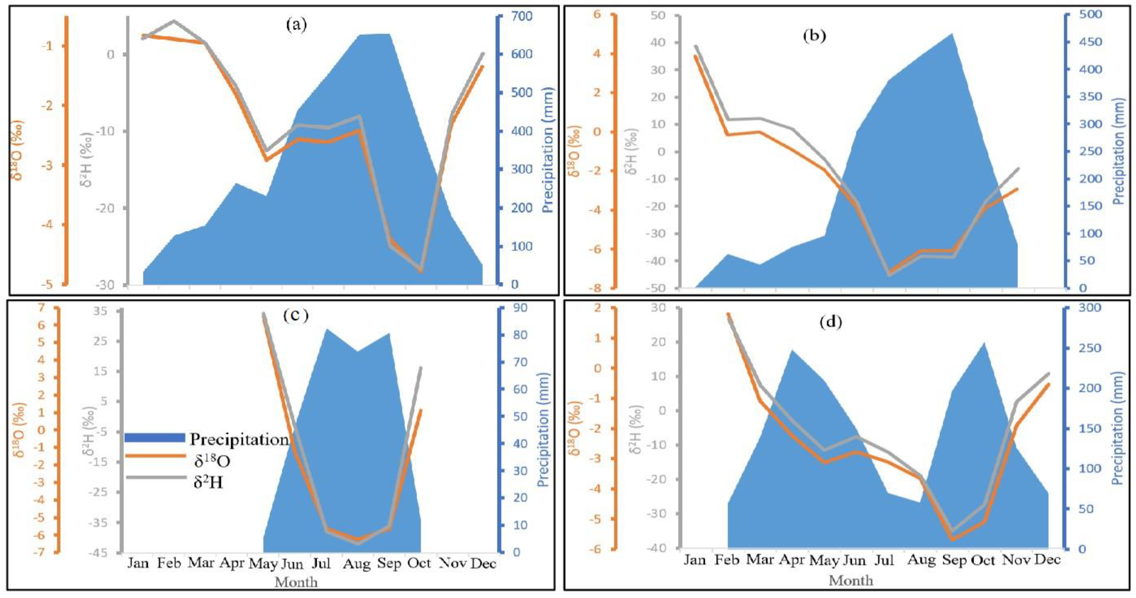
4.1. Isotopic Signature of Precipitation

As rainfall represents the input function of subsurface water, it is important to study its isotopic signal to better understand hydrological processes. The available isotopic data for the monthly precipitation over the country are presented in Table 2. Eight stations have been identified from diverse geomorphoclimatic zones. Annual weighted mean values of δ18O and δ2H in precipitation ranged from −5.70‰ to −2.95‰ and from −35.9 to −12.83‰, respectively (Table 1). Therefore, on average, rainfall is more depleted in the far north (Sahelian climate) and more enriched in coastal areas (equatorial maritime climate).
A latitudinal effect [37] can be clearly observed over the country in Figure 3. Indeed, rainfall isotopic composition decreases with the latitude and the distance from the coast. This decreasing trend defines a latitudinal gradient of −0.32‰/degree towards the north. However, Figure 3 shows that there is no altitudinal effect. This suggests that the spatial variation of rainfall isotopes in Cameroon is mainly controlled by the migration of the Intertropical Continental Zone, which transports vapor from the south to the north and therefore generate precipitation events throughout the year [14]. The depletion of water vapor towards the north would therefore be reflected in precipitation isotopes according to [38], who showed that there was no post-condensational effects. This is clearly similar to the Rayleigh distillation model in which heavy isotopes are continuously removed from the air masses [37]. The lack of altitudinal effect may be related to re-evaporation of raindrops. This phenomenon is responsible for the re-enrichment of rainfall mainly during the dry season when the atmosphere is poorly saturated by humidity [38]. On the other hand, High (>10‰) weighted mean value of deuterium excess corresponding to 11.12‰ when considering all the samples over the country confirms well the effect of water vapor mixing from different sources [38] over the country (Table 1). In addition, the convective activity would also have a stronger influence on precipitation isotopes, as [38] explained well that local (topography, local meteorological parameters) and regional (large-scale convection) factors control more or less the isotopic signature of rainfall. Figure 3 clearly shows that the isotopic signature rainfall from humid coastal areas and south plateau are very similar even in term of d-excess (Table 2). This suggests a dominance of large-scale meteorological dynamic for these stations. Samples in the north lowland (semi-arid climate) seem to be more subjected to rainfall re-evaporation (d-excess < 10; Table 2).
The seasonal variation of rainfall isotopes exhibits a W shape in coastal areas and in the southern plateau region with minima in spring and autumn periods (Figure 4). From January–February to April–May, δ18O decreases; an enrichment in isotopic content is observed in summer (in June, July or August depending on the station); isotope contents then decrease until September or October and a new increase occurs until December. This relative homogeneity across these two regions suggests that isotopic seasonality is controlled by mechanisms of, at least, on regional scale. This can be supported by the fact that the amount effect [37] is not often observed especially in humid coastal area (Figure 4). This lack of control of local meteorological settings on rainfall isotopic signature would reflect a dominance of large-scale meteorological dynamics [38].
Such similarity between regions with different rainfall regime suggests that isotopic seasonality is controlled by mechanisms acting at a regional scale involving all southern Cameroon. The lack of correlation between δ18O and local precipitation amount (0.14 < R2 < 0.18) confirms this dominance of regional phenomena. This is in good agreement with [38], who highlighted the control of regional convective activity on isotopic signal in the Western–Central Africa zone. However, the seasonal cycle from highlands and Sudanese climate shows a V shape (Figure 4) with strong link between local precipitation and isotopes (0.55 < R2 < 0.62). Rainwater there is more depleted during the summer period (Figure 4).
Finally, regarding these heterogeneities in rainfall signature and temporal variation, it is not possible to propose a meteoric water line for the whole country. Meteoric water lines are instead proposed for each geomorphoclimatic zones in order to define as well as possible a regional isotopic framework inside the country. The different equations are:
Humid coastal area: δ2H = (7.07 ± 0.16) δ18O + (8.23 ± 0.50); R2 = 0.91
Highlands: δ2H = (8.05 ± 0.22) δ18O + (12.54 ± 0.99); R2 = 0.98
North lowland: δ2H = (6.82 ± 0.37) δ18O + (2.02 ± 1.91); R2 = 0.96
South plateau: δ2H = (8.34 ± 0.23) δ18O + (14.52 ± 0.81); R2 = 0.98
The slope below 8 reflects the influence of re-evaporation of raindrops. This phenomenon is not observable in the highlands and south plateau. The humid coastal zone appears also to be less homogeneous regarding the R2.

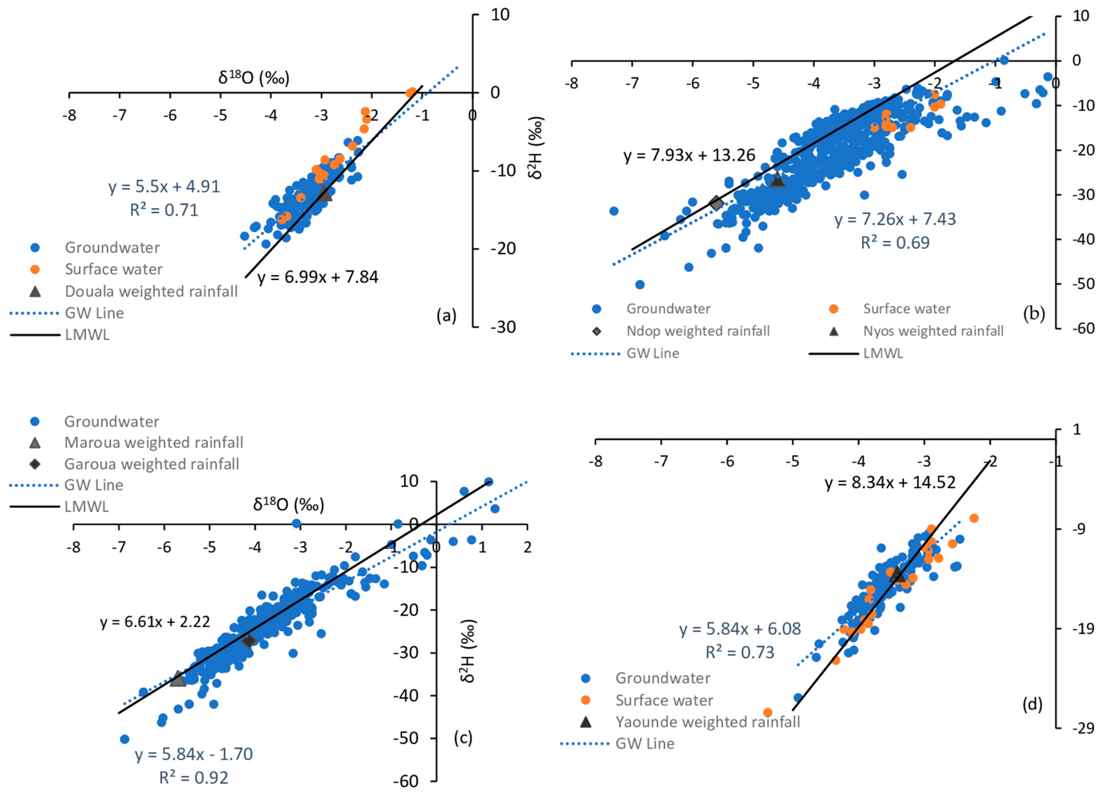
4.2. Spatial Pattern of Groundwater and Surface Water Isotopes: Inferring Groundwater Recharge Conditions

Groundwater and surface water isotopes are known to integrate the precipitation isotope values and show smaller ranges than precipitation (Table 3 and Figure 5). Based on the amount-weighted t-test, mean δ18O and δ2H values of the groundwater and surface water show no statistically significant differences with those of precipitation. However, groundwater δ18O values show a significantly higher variance than surface water. This reflects the high heterogeneity of groundwater isotopic signal and therefore the various sources of water recharge. This is exacerbated in highlands and north lowlands domains where the local geomorphology can be more complex. Deuterium excess, on the other hand, presents various behaviors. The d-excess values of groundwater in highlands and south plateau are lower than precipitation d-excess (Table 2 and Table 3), suggesting an evaporative loss of rainwater before it reaches the aquifer and as it flows through streams. In humid coastal area and north lowland, the groundwater d-excess is relatively in the same range than d-excess in precipitation. However, in the north, it is worthwhile noting that precipitation d-excess already shows evidence of evaporation. This is in agreement with the atmospheric conditions at the country scale and suggests an existence of various mechanisms of rainwater infiltration. This is indeed confirmed by the d-excess variance, which is much higher in groundwater than in surface water (Table 3).
Figure 5 shows that some surface water could reflect groundwater isotopes because they are sustained by groundwater discharge [40]. Moreover, as the average stream d-excess value is close to the one recorded in groundwater, it is clear that the source is the same for surface and groundwater. This is the case in humid coastal area while in the others zones, groundwater d-excess > surface water d-excess reflecting the discharge of groundwater into surface water bodies.
In the humid coastal zone, isotopes values appear more depleted than the weighted mean rainfall and above the LMWL (Figure 5). This can be attributed to a preferential recharge of the aquifer [41] by the most depleted rainfall. Since the temporal variations of isotopic content in the precipitation (Figure 4) have clearly shown that the spring and autumn precipitation (the most important of the year) are more depleted, the differences observed between groundwater and rainwater isotopic content can then be attributed to a winter and autumn preferential recharge. This can be supported by the fact during the dry season (November to February), the soil is dry and the precipitation occurring at this time only moistens the soil and sustains the vegetation. On the other hand, during the peak (July–August) of the rainy season, the soil is saturated with water and the frequency of floods increase; therefore, there is no recharge [21].
In the highlands and northern lowlands, a large majority of groundwater samples plot along the LMWLs with some enriched and other ones depleted compared to the weighted mean precipitation. The first case is the most observed, indicating an indirect infiltration of rainwater. Indeed, according to [42,43] who presented in detail the architecture of these territories, the shallow aquifer would be recharged by precipitation via channel rivers. However, the depleted groundwater along the LMWL would refer to mountain system recharge (MSR) via the Mandara Mountains (Figure 1) in the western side of the far north or thanks to steep landscape in the north west of the country. This mechanism is explained by streams loss at mountain fronts and resulting subsurface transfer of groundwater from the mountain blocks to the adjacent aquifer [44]. Indeed, due to the altitude effect, recharged water from mountains will exhibit a depleted signature.
The south plateau gathers three types of recharge modes:
(i)
the samples below the LMWL and above the weighted mean precipitation, with an enriched signature, indicate a slow or an indirect infiltration of rainwater.
(ii)
cluster of samples close to the weighted mean precipitation and well on the LMWL, refers to an autochthonous recharge of the aquifer, also defined as diffuse recharge, i.e., direct infiltration of rain followed by percolation to the water table [44].
(iii)
For the third group, samples below the weighted mean rainfall and above the LMWL, the depleted signature here may be related to a MSR as this region is characterized by local hills, valleys and plateaus [21].
Finally, regarding the composition of rainwater, surface and subsurface water isotopes, and the discussion above, the spatial groundwater isotope variation does not reflect the precipitation isotope distribution due to the general alteration of the isotopic signal in groundwater.
Supplementary Materials provide a map of distribution of rainwater and groundwater isotopes over the investigated sites of the country.

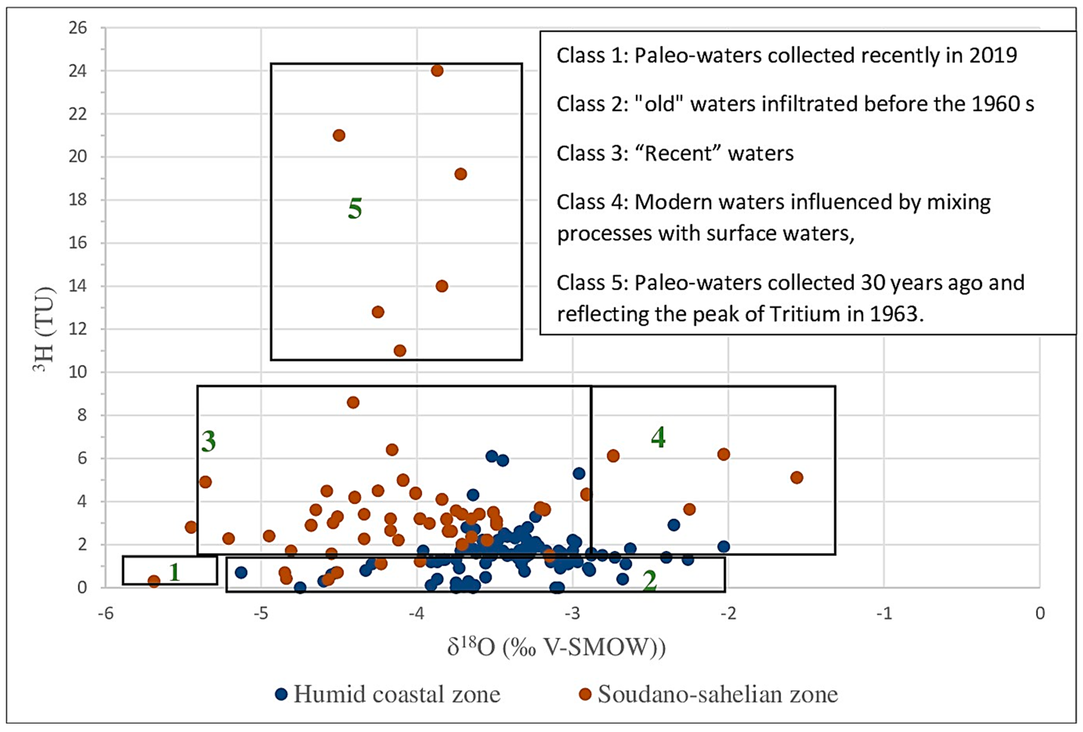
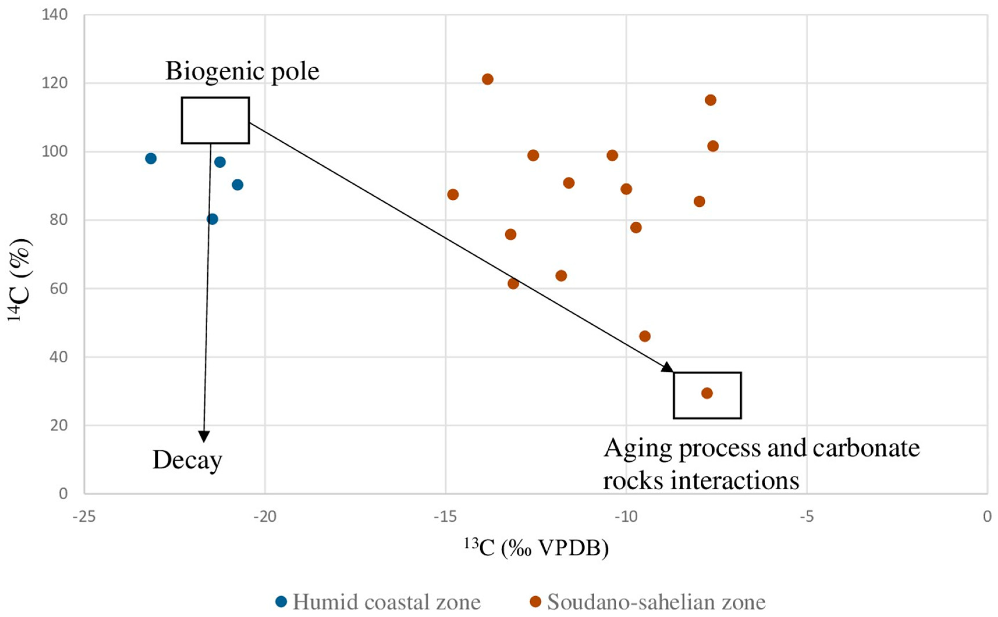
4.3. Identification of Strategic Paleo-Groundwater in Cameroon and Management Strategies for Such Resources

This section explores results from radioactive isotopes (3H and 14C) in groundwater over the Cameroonian territory.
These tracers give insights on groundwater residence time referring to the time the water molecule “resides” in the groundwater portion of the hydrologic cycle [45]. The residence time is an important factor for the development of hydrogeological concepts influencing the origin, recharge and exchange with the aquifer rocks. In addition, contamination and risk assessment depend strongly on the estimated residence of groundwater [45].
Concerning tritium (3H), it is the simplest and most intimate tracer for determining short residence time [45] and suspect the presence of paleo-groundwater. Its concentration in groundwater depends primarily on the initial atmospheric content at the time of recharge and the radioactive decay that has occurred since infiltration [45]. Since there are several sources of tritium in the atmosphere, this tracer is not used for age dating in the conventional way but its occurrence in groundwater suggests the extent of migration of modernpost-1950s recharge. Indeed, groundwater with 3H concentrations less than 1 TU is regarded as having a pre-1952 age, a date which represents the beginning of the artificial release of tritium through nuclear tests. Therefore, the presence of 3H contents above the detection limit (1 TU) in groundwater indicates the contribution of recent water infiltration in various proportions.
However, when plotting 3H versus δ18O, the situation can be more complex with many classifications of groundwater ages. Based on data collected throughout the whole country, different classes of groundwater ages are identified (Figure 6):
Class 1: Groundwater with very low δ18O and negligible tritium content. This is observed in the far north region (Sudano-Sahelian domain) of Cameroon and can be identified as “paleo-water” [45], i.e., recharged during a more humid and colder period than today. The previous investigations in the Lake Chad basin summarized by [46] indicated the presence of very old groundwater in this part of the country.
Class 2: Groundwater with low tritium concentrations (TU ≤ 1) and varying δ18O between (−5.69‰ and −2.26‰). These are observed in majority in the far north region and in the coastal area of Douala. They correspond to “old” waters infiltrated before the 1960′s (peak of tritium contents in the atmosphere due to bomb tests). The wide range in δ18O contents can be related to samples which undergone a strong influence of evaporative effects during the recharge or during the storage in the aquifer [45].
Class 3: Groundwater with tritium contents between 1 and ~8.5 TU and signature close to that of central coastal and Sahelian are of very recent origin and can be considered as “recent” waters recharged during the rainy season, or as a mixing with a large part with recent waters. In this case, groundwater from the Sudanese zone, far north and highlands and from the coastal zone are observed (Figure 1).
Class 4: Groundwater with tritium content between 1 and ~8.5 TU and enriched δ18O content compared to the rainfall signature. These groundwaters represent a mixing with evaporated surface waters due to more or less active recharge from local river (Figure 5), namely, the Logone River.
Class 5. Groundwater with very high 3H content, clearly above the actual rainfall concentration. These values, up to 24 TU, correspond to groundwaters collected 30 years ago and infiltrated at the time of the 1963 bomb peak of tritium in the atmosphere. These samples might belong nowadays to the group 1 of paleowater regarding the radioactive decay of tritium. Considering that the tritium content in N’Djamena station was estimated at 1371 TU in 1963 [26] which is relatively high for such low latitude region, but confirmed by [47] through isoscape reconstruction. Therefore, it is not unrealistic to observe such values in groundwater.
Confirmation of Paleo and old groundwater are provided by the radiocarbon which is useful to determine groundwater residence time over timescales up to 30 ka [45]. Figure 7 shows carbon isotopes relationship (δ13C/14C) in the aquifer systems of Douala and far north Cameroon in order to obtain further information on the residence time of groundwater. Different carbon isotopes signatures are observed, with at least two end members. The first end-member is marked by high percentage of 14C and depleted δ13C values indicating the domination of the soil-derived CO2. Samples from the coastal plain are gathered around this end-member. The second end-member seems to include groundwater samples involved under closed system conditions. This groundwater from the Sahelian region would represent the most confined characterized by the lowest 14C activities and the most enriched δ13C values similar to that found for instance in deep aquifers of southern Tunisia [48]. This trend seems to be related to distinct water–rock interaction conditions enhanced by high groundwater residence times. Indeed, Long water residence times enhance equilibration with aquifer carbonate minerals resulting in lower 14C activities and more enriched δ13C compositions [45]. Between the two end-members, intermediate groundwater samples are found originating all from the northern plain which correspond to semi-arid climate. It is clear that strategic paleowater resources in Cameroon would originate mainly from this latter region. This groundwater, not vulnerable to surface contamination and less susceptible to evaporation, should be strongly protected and preserved. This resource must be considered by the government like a mine: exploitation must be controlled and require formal authorization. Managers should promote the establishment of protection perimeters around the tapping points and multilevel screened wells must be prohibited to avoid mixing between different flow paths. Finally, paleo-groundwater must be mapped and quantified for allowing a sustainable use of this resource.

4.4. Necessary Future Isotopic Investigations to Cope with the Challenges of Development and Water Resources Protection

Taking into account the synthesis and results provided above, four priorities must guide the future isotope hydrology investigations in the country: (i) identification and management of deep confined aquifers in the sedimentary basins, (ii) freshwater–marine water interfaces in coastal–estuarine zones, (iii) hydroecology through studies of groundwater dependent ecosystems, and (iv) isotope tracing of aquifer pollution.
Since the knowledge of groundwater residence time is essential information for a sustainable abstraction of aquifers, a campaign on identification and characterization of groundwater renewability must be conducted. This is even important to develop groundwater management policies. However, for the moment only the Douala coastal basin and aquifer in the far north have been investigated on this point. Multi-isotopic tracers should be developed for instance to characterize “young” waters. As dating with tritium can be relative, the use of gas can be more helpful. CFC/SF6 method can be for instance insightful to elucidate the mixing processes and to discriminate the different flow paths within the aquifer. Likewise, the 3H/3He is now well widespread and able to provide a realistic groundwater age. For old and paleo-groundwater, 39Ar must be combined with 14C/13C to have a clear discrimination between young and paleo groundwater and to better identify what is generally considerate as intermediate between the two end-members. Such work leads to groundwater age mapping, a perfect tool for building better water supply schemes.
Drinking water supply boreholes in urban and coastal regions of Cameroon present a significant risk with regard to saline intrusion. The situation of coastal groundwater requires in-depth investigations in order to understand the mechanisms causing salinization and especially their modalities. A better understanding of the coastal hydrogeological deposit geometry and aquifer potential would make it possible to propose strategies to limit salt phenomena and could contribute to the long-term sustainability of exploitation on this site. Boron stable isotopes can be efficient here.
Cameroon is characterized by the presence of numerous large groundwater-dependent wetlands in the different climatic domains, which provide a large number of ecosystem services to populations (human food, maintenance of biodiversity, contribution to water regulation, connectivity with groundwater, etc.). However, these environments are increasingly impacted either by human activities or by climatic disturbances. Thus, new transdisciplinary studies are necessary in order to know the hydrological behavior of these hydro-ecosystems and especially to be able to estimate their future behavior under the new constraints imposed by current global changes. Isotopes could be monitored in water bodies, plants and some species for instance.
Finally, stable isotopes and radioactive tracers must be combined with δ11B, δ15N-NO318O-NO3, and contaminants of emerging concerns to investigate water pollution in agricultural and urban areas of the countries. Indeed, being the leading economic power of the Central African subregion, Cameroon is facing many challenges related to urban sprawl, exponential demographic growth, and intensification/industrialization of agriculture to cope with the growing demand [9]. Isotope hydrology can therefore help to provide holistic information on groundwater quality.

5. Conclusions

The use of isotopes to characterize groundwater resources in Cameroon over the past 30 years has significantly improved the understanding of hydrological processes affecting its recharge, distribution and groundwater flow paths. Nevertheless, most isotope data are a result of intermittent short-term studies, and only a few represent long-term monitoring programs. Only rainfall and rivers have undergone long-term investigations in few regions giving valuable information on aquifers recharge and groundwater-surface water interactions. From the beginning of 1990’s when isotopes techniques were first applied in the far north region up to now, isotope hydrologic data are used more frequently. However, the far north region which corresponds to the Sahelian domain and the locality of Douala (humid coastal zone) remain the most investigated. It is evident that this limited sampling and coverage of monitoring presents a high risk of e.g., not detecting contamination events and will not allow establishing a national policy of water management in the current context of global changes. Likewise, radioactive isotopes are still rarely implemented leading to poor knowledge on deep aquifers and even young groundwaters of the country.
Finally, it is worthwhile noting that it is the first time that isotope data from diverse regions of the Cameroon are gathered together in different geomorphoclimatic domain. The results from this review can be used to prepare guidelines for future isotope monitoring that will provide a better overall understanding of water dynamic and will help for designing long-term water resources monitoring.

Supplementary Materials

The following supporting information can be downloaded at https://www.mdpi.com/article/10.3390/w15234056/s1.

Author Contributions

Conceptualization, B.N. and F.H.; methodology, B.N., F.H. and S.N.B.-N.; software, F.S., D.K., B.G. and P.M.; validation, B.N. and S.N.B.-N.; data curation, B.N., P.M. and B.D.; writing—original draft preparation, B.N.; writing—review and editing, B.N., F.H., F.S., E.F. and D.K.; visualization, B.N.; English correction, E.F.; supervision, F.H. and S.N.B.-N. All authors have read and agreed to the published version of the manuscript.

Funding

This research received no external funding.

Data Availability Statement

The data presented in this study are available on request from the corresponding author.

Acknowledgments

The authors are grateful to all their peers who accepted to share their data. We thank particularly the International Atomic Energy Agency (IAEA) for its great support for the development of isotopic techniques in Cameroon through many projects such as CMR/8/005, CMR/8/008, RAF/7/011 and RAF/7/019.

Conflicts of Interest

The authors declare no conflict of interest.

References

  1. Gonfiantini, R.; Fröhlich, K.; Araguás-Araguás, L.; Rozanski, K. Isotopes in Groundwater Hydrology; Kendall, C., McDonnell, J.J., Eds.; Isotope Tracers in Catchment Hydrology; Elsevier: Amsterdam, The Netherlands, 1998; pp. 203–246. ISBN 9780444815460. [Google Scholar] [CrossRef]
  2. Penna, D.; Hopp, L.; Scandellari, F.; Allen, S.T.; Benettin, P.; Beyer, M.; Geris, J.; Klaus, J.; Marshall, J.D.; Schwendenmann, L.; et al. Ideas and perspectives: Tracing terrestrial ecosystem water fluxes using hydrogen and oxygen stable isotopes―Challenges and opportunities from an interdisciplinary perspective. Biogeosciences 2018, 15, 6399–6415. [Google Scholar] [CrossRef]
  3. Sankoh, A.A.; Derkyi, N.S.A.; Frazer-Williams, R.A.D.; Laar, C.; Kamara, I. A Review on the Application of Isotopic Techniques to Trace Groundwater Pollution Sources within Developing Countries. Water 2022, 14, 35. [Google Scholar] [CrossRef]
  4. Atekwana, E.A.; Seeger, E.J. Carbonate and carbon isotopic evolution of groundwater contaminated by produced water brine with hydrocarbons. Appl. Geochem. 2015, 63, 105–115. [Google Scholar] [CrossRef]
  5. Jasechko, S. Global Isotope Hydrogeology―Review. Rev. Geophys. 2019, 57, 835–965. [Google Scholar] [CrossRef]
  6. Tadesse, A.; Anagnostou, E.N. African convective system characteristics determined through tracking analysis. Atmos. Res. 2010, 98, 468–477. [Google Scholar] [CrossRef]
  7. Saghir, J.; Santoro, J. Urbanization in Sub-Saharan Africa; Center for Strategic & International Studies Report; CSIS: Washington, DC, USA, 2018; Available online: www.csis.org (accessed on 5 October 2021).
  8. Wohl, E.; Barros, A.; Brunsell, N.; Chappell, N.A.; Coe, M.; Giambelluca, T.; Goldsmith, S.; Harmon, R.; Hendrickx, J.M.H.; Juvik, J.; et al. The hydrology of the humid tropics. Nat. Clim. Chang. 2012, 2, 655–662. [Google Scholar] [CrossRef]
  9. Nlend, B.; Celle-Jeanton, H.; Huneau, F.; Ketchemen-Tandia, B.; Fantong, W.; Boum-Nkot, S.N.; Etame, J. The impact of urban development on aquifers in large coastal cities of West Africa: Present status and future challenges. Land Use Policy 2018, 75, 352–363. [Google Scholar] [CrossRef]
  10. Xu, Y.; Seward, P.; Gaye, C.; Lin, L.; Olago, D.O. Preface: Groundwater in Sub-Saharan Africa. Hydrogeol. J. 2019, 27, 815–822. [Google Scholar] [CrossRef]
  11. Boretti, A.; Rosa, L. Reassessing the projections of the World Water Development Report. NPJ Clean Water 2019, 2, 15. [Google Scholar] [CrossRef]
  12. Olivry, J.-C. Fleuves et Rivières du Cameroun, Collection “Monographies Hydrologiques. ORSTOM”; ORSTOM: Paris, France, 1986; p. 781. [Google Scholar]
  13. Boum-Nkot, S.N.; Nlend, B.; Ntamak-Nida, M.-J. Beatrice Ketchemen-Tandia’s contributions to isotope hydrology in sub-Saharan Africa. Hydrogeol. J. 2022, 30, 1911–1916. [Google Scholar] [CrossRef]
  14. Djoufack, V. Etude Multi-échelles Des Précipitations et du Couvert Végétal au Cameroun: Analyse Spatiale, Tendances Temporelles, Facteurs Climatiques et Anthropiques de Variabilité du NDVI. Ph.D. Thesis, Université de Bourgogne, Dijon, France, 2011. [Google Scholar]
  15. Ndéléc, A.; Nsifa, E.N. Le Complexe du Ntem (Sud-Cameroun): Une Serie Tonalitique Trondhemitique Archéenne Typique; Schandelmeier, H., Matheis, G., Eds.; Current Research African Earth Sciences: Berlin, Germany, 1987; pp. 3–6. [Google Scholar]
  16. Moreau, C.; Regnoult, J.M.; Deruelle, B.; Robineau, B. A new tectonic model for the Cameroon Line, Central Africa. Tectonophysics 1987, 141, 317–334. [Google Scholar] [CrossRef]
  17. Mvondo, O.F. Surrection Cénozoïque de L’Ouest de L’Afrique à Partir de Deux Exemples: Le Plateau Sud Namibien la Marge Nord Camerounaise. Ph.D. Thesis, Université de Rennes 1, Rennes, France, 2010; 309p. (In French). [Google Scholar]
  18. PRECASSEM Carte Géologique du Cameroun à 1/1 000 000. 2021. Available online: https://sigm-online.maps.arcgis.com/home/index.html (accessed on 20 October 2023).
  19. United Nations. Groundwater in North and West Africa: Cameroon; Natural Resources/Water Series No. 18, ST/TCD/5; United Nations Department of Technical Cooperation for Development and Economic Commission for Africa: New York, NY, USA, 1988.
  20. Lachassagne, P.; Dewandel, B.; Wyns, R. Review: Hydrogeology of weathered crystalline/hard-rock aquifers—Guidelines for the operational survey and management of their groundwater resources. Hydrogeol. J. 2021, 29, 2561–2594. [Google Scholar] [CrossRef]
  21. Fongoh, E.J.; Celle, H.; Nlend, B.; Boum-Nkot, S.N.; Ako, A.A.; Huneau, F.; Caillon, N.; Ntamak-Nida, M.J. Multitracer approach towards an improved understanding of shallow hard rock aquifers and a more sustainable groundwater management, case of Yaounde, Cameroon. Environ. Earth Sci. 2023, 82, 106. [Google Scholar] [CrossRef]
  22. Bourgeois, M. Etude Hydrogéologique D’orientation Pour le Captage D’eau Minérale au Cameroun; BRGM 77 AGE 013; Rapport: Paris, France, 1977. [Google Scholar]
  23. Njitchoua, R. Hydrochimie et Géochimie Des Eaux Souterraines de la Nappes Des “Grès de Garoua”; Université Paris-Sud: Gif-sur-Yvette, France, 1991; 162p. [Google Scholar]
  24. Ketchemen, B. Hydrogéologie du Grand Yaéré (Extrême Nord du Cameroun); Synthèse Hydrogéologique et étude de la Recharge Par les Isotopes de L’environnement, Thèse 3ème Cycle; University of Dakar: Dakar, Senegal, 1992; p. 172. (In French) [Google Scholar]
  25. IAEA. Les Ressources en Eau au Sahel: Etudes Hydrogéologiques et Hydrologiques en Afrique de L’Ouest Par Les Techniques Isotopiques; TEC-DOC-721; IAEA: Vienna, Austria, 1993; pp. 107–122. [Google Scholar]
  26. IAEA/WMO Global Network of Isotopes in Precipitation. The GNIP Database. 2021. Available online: https://nucleus.iaea.org/wiser (accessed on 20 October 2023).
  27. Nlend, B.; Celle-Jeanton, H.; Huneau, F.; Garel, E.; Boum-Nkot, S.N.; Etame, J. Shallow urban aquifers under hyper-recharge equatorial conditions and strong anthropogenic constrains. Implications in terms of groundwater resources potential and integrated water resources management strategies. Sci. Total Environ. 2020, 757, 143887. [Google Scholar] [CrossRef]
  28. Ketchemen-Tandia, B. Déterminants Hydrogéologiques de la Complexité du Système Aquifère du Bassin Sédimentaire de Douala (Cameroun). Ph.D. Thesis, University of Cheick Anta Diop, Dakar, Senegal, 2011; 211p. (In French). [Google Scholar]
  29. Wotany, E.R.; Wirmvem, M.J.; Fantong, W.Y.; Ayonghe, S.N.; Wantim, M.N.; Ohba, T. Isotopic composition of precipitation and groundwater onshore of the Rio del Rey Basin, southwest Cameroon: Local meteoric lines and recharge. Appl. Water Sci. 2021, 11, 141. [Google Scholar] [CrossRef]
  30. Emvoutou, H.C.; Ketchemen Tandia, B.; Ngo Boum Nkot, S.; Ebonji, R.C.; Nlend, Y.B.; Ekodeck, G.E.; Stumpp, C.; Maloszewski, P.; Faye, S. Geologic factors controlling groundwater chemistry in the coastal aquifer system of Douala/Cameroon: Implication for groundwater system functioning. Environ. Earth Sci. 2018, 77, 219. [Google Scholar] [CrossRef]
  31. Wirmvem, M.J.; Ohba, T.; Anye Nche, L.; Tchakam Kamtchueng, B.; Kongnso, W.E.; Mimba, M.E.; Bafon, T.G.; Yaguchi, M.; Takem, G.E.; Fantong, W.Y.; et al. Effect of diffuse recharge and wastewater on groundwater contamination in Douala Cameroon. Environ. Earth Sci. 2017, 76, 354. [Google Scholar] [CrossRef]
  32. Ako, A.A.; Eyong, G.E.T.; Shimada, J.; Koike, K.; Hosono, T.; Ichiyanagi, K.; Richard, A.; Tandia, B.K.; Nkeng, G.E.; Roger, N.N. Nitrate contamination of groundwater in two areas of the Cameroon Volcanic Line (Banana Plain and Mount Cameroon area). Appl. Water Sci. 2014, 4, 99–113. [Google Scholar] [CrossRef]
  33. Kamtchueng, B.T.; Fantong, W.Y.; Wirmvem, M.J.; Tiodjio, R.E.; Takounjou, A.F.; Asai, K.; Djomou, S.L.B.; Kusakabe, M.; Ohba, T.; Tanyileke, G.; et al. A multi-tracer approach for assessing the origin, apparent age and recharge mechanism of shallow groundwater in the Lake Nyos catchment, Northwest, Cameroon. J. Hydrol. 2015, 523, 790–803. [Google Scholar] [CrossRef]
  34. Wirmvem, M.J.; Mfumbu, E.; Kamtchueng, B.; Engome, R.; Bafon, T.; Asaah, A.; Fantong, W.Y. Shallow groundwater recharge mechanism and apparent age in the Ndop plain, northwest Cameroon. Appl. Water Sci. 2017, 7, 489–502. [Google Scholar] [CrossRef]
  35. Bello, M.; Ketchemen-Tandia, B.; Nlend, B.; Huneau, F.; Fouepe, A.; Fantong, W.Y.; Ngo Boum-Nkot, S.; Garel, E.; Celle Jeanton, H. Shallow Groundwater Quality Evolution after 20 Years of Exploitation in the Southern Lake Chad: Hydroche istry and Stable Isotopes Survey in the Far North of Cameroon. Environ. Earth Sci. 2019, 78, 474. [Google Scholar] [CrossRef]
  36. IAEA Technical Procedures for GNIP Stations. Vienna, Austria, 2012, p. 12. Available online: http://www.naweb.iaea.org/napc/ih/IHS_resources_gnip.html (accessed on 5 October 2023).
  37. Dansgaard, W. Stable isotopes in precipitation. Tellus 1964, 16, 436–468. [Google Scholar] [CrossRef]
  38. Nlend, B.; Celle-Jeanton, H.; Risi, C.; Pohl, B.; Huneau, F.; Boum-Nkot, S.N.; Seze, G.; Roucou, P.; Camberlin, P.; Etame, J.; et al. Identification of processes that control the stable isotope composition of rainwater in the humid tropical West-Central Africa. J. Hydrol. 2020, 584, 124650. [Google Scholar] [CrossRef]
  39. Wirmvem, M.J.; Ohba, T.; Fantong, W.Y.; Ayonghe, S.N.; Suila, J.Y.; Asaah, A.N.E.; Asai, K.; Tanyileke, G.; Hell, J.V. Monthly δ18O, δD and Cl characteristics of precipitation in the Ndop plain, Northwest Cameroon: Baseline data. Quat. Int. 2014, 338, 35–41. [Google Scholar] [CrossRef]
  40. Kendall, C.; Coplen, T.B. Distribution of oxygen-18 and deuterium in river waters across the United States. Hydrol. Process. 2001, 15, 1363–1393. [Google Scholar] [CrossRef]
  41. Jaunat, J.; Celle-Jeanton, H.; Huneau, F.; Dupuy, A.; Le Coustumer, P. Characterisation of the input signal to aquifers in the French Basque Country: Emphasis on parameters influencing the chemical and isotopic composition of recharge waters. J. Hydrol. 2013, 496, 57–70. [Google Scholar] [CrossRef]
  42. Vassolo, S.; Seeber, K.; Wilczok, C.; Daira, D.; Bala, A.; Hamit, A. Traces of the different levels of paleo Lake Chad on groundwater resources. In Proceedings of the IAH Congress, Rome, Italy, 14–18 September 2015. [Google Scholar]
  43. Tchindjang, M. Paradoxes et Risques Dans Les Hautes Terres Camerounaise: Multifonctionnalité Naturelle et Sous Valorisation Humaine; Habilitation à Diriger les Recherches (HDR); Université de Paris 7: Paris, France, 2012; 266p. [Google Scholar]
  44. Meixner, T.; Manning, A.H.; Stonestrom, D.A.; Allen, D.M.; Ajami, H.; Blasch, K.W.; Brookfield, A.E.; Castro, C.L.; Clark, J.F.; Gochis, D.J.; et al. Implications of projected climate change for groundwater recharge in the western United States. J. Hydrol. 2016, 534, 124–138. [Google Scholar] [CrossRef]
  45. Bethke, C.M.; Johnson, T.M. Groundwater Age and Groundwater Age Dating. Annu. Rev. Earth Planet. Sci. 2008, 36, 121–152. [Google Scholar] [CrossRef]
  46. Nour, A.M.; Huneau, F.; Ali, A.M.; Saleh, H.M.; Boum-Nkot, S.N.; Nlend, B.; Djebebe-Ndjiguim, C.; Foto, E.; Sanoussi, R.; Araguas-Araguas, L.; et al. Shallow Quaternary groundwater in the Lake Chad basin is resilient to climate change but requires sustainable management strategy: Results of isotopic investigation. Sci. Total Environ. 2022, 851, 158152. [Google Scholar] [CrossRef]
  47. Terzer-Wassmuth, S.; Araguás-Araguás, L.J.; Copia, L.; Wassenaar, L.I. High spatial resolution prediction of tritium (3H) in contemporary global precipitation. Sci. Rep. 2022, 12, 10271. [Google Scholar] [CrossRef]
  48. Trigui, M.R.; Trabelsi, R.; Zouari, K.; Agoun, A. Implication of hydrogeological and hydrodynamic setting on water quality of the Complex Terminal Aquifer in Kebili (southern Tunisia): The use of geochemical indicators and modelling. J. Afr. Earth Sci. 2021, 176, 104121. [Google Scholar] [CrossRef]
Figure 1. Geomorphology and distribution of rainfall from certain localities over Cameroon. (Data source: national meteorological service).
Water 15 04056 g001
Figure 3. Relationship between δ18O in precipitation versus (a) latitude, (b) altitude and (c) distance from the coast. (Data source: [26,29,39]).
Water 15 04056 g003
Figure 4. Monthly mean variation of δ18O and δ2H in precipitation from (a) humid coastal area (≤200 m), (b) highland (≥900 m), (c) north lowland (≥160 m) and (d) south plateau (600–900 m) of Cameroon. (Data source: [26,29,39]).
Water 15 04056 g004
Figure 5. δ2H and δ18O diagram for groundwater samples from (a) humid coastal area (≤200 m), (b) highland (≥900 m), (c) north lowland (≥160 m) and (d) south plateau (600–900 m) in Cameroon. In addition to weighted mean precipitation, local meteoric water line (LMWL) and groundwater line (GW Line) are also plotted.
Water 15 04056 g005
Figure 6. 3H versus δ18O in shallow groundwater of various places in Cameroon.
Water 15 04056 g006
Figure 7. δ13C versus 14C in shallow groundwater over some regions of Cameroon.
Water 15 04056 g007
Table 1. Rainwater and groundwater isotopic dataset according to the different geomorphoclimatic domains. na and nb refer to the number of rainwater and groundwater samples, respectively. References (data sources) are also provided.
Geomorpho-Climatic RegionReference Rainfall StationsnaStudied AquifernbReferences
Humid coastal areasDouala
Lobe
Mundembe
160
12
12
Multi-aquifer system (gravels/sands/silts/clays)250
6
[27,28,29,30,31]
Volcanics41[32]
South plateauYaoundé35Basement76[21]
Highlands Ndop
Nyos
12
8
Basement 58[33,34]
Northern lowlandsGaroua
Maroua
28
24
Sandstones
Sands
32
269
[23,24,35]
Table 2. Geographical, meteorological and isotopic parameters of 8 sampling stations in Cameroon.
StationLat.
(°)
Long.
(°)
Alt. (m.a.s.l)DC *
(km)
RecordnMean Interannual Meteorological ParametersMean Arithmetical ContentsWeighted MeanLMWL *
P * (mm)T * (°C)δ18O (‰)δ2H (‰)d-Excess (‰)δ18O (‰)δ2H (‰)d-Excess (‰)SlopeIntercept (‰)R2
Douala4.049.7318352006–2021160362327.1−2.44−9.2010.31−2.95−12.8310.776.997.840.91
Lobe5.159.186032201212318927.2−2.82−10.0012.57−3.69−17.5311.967.9712.480.95
Mundemba4.958.873061201212506727.3−2.49−8.4711.41−3.47−16.1711.627.7510.790.95
Yaoundé3.8611.467361912013–2014
2020–2021
35162223.7−2.90−9.7013.54−3.41−13.4813.778.3414.520.98
Garoua9.3012.382507501991–19922876727.3−4.19−28.155.34−5.38−27.745.428.467.260.97
Maroua10.5914.323969202020–20212451627.8−3.03−17.856.42−5.70−35.909.716.612.220.96
Ndop5.9810.42117824420141214025.4−2.96−10.2113.47−5.61−31.9312.987.9313.260.99
Nyos6.4810.299002902013833521.7−3.33−15.7010.90−4.60−26.4810.308.3812.151.00
Notes: * LMWL = local meteoric water line; P = annual precipitation; T = mean annual temperature; DC = distance to the coast, n = number of samples.
Table 3. Statistical summary of groundwater and surface water isotopic composition in Cameroon according to different geomorpho-climatic zones. The number of samples (n) is also given.
Water TypesGeomorphoclimatic DomainnSampling
Period
δ18O (‰)δ2H (‰)D-Excess
Min MaxMeanSt. Dev.Min MaxMeanSt. Dev.Min MaxMeanSt. Dev.
GroundwaterHumid coastal area2562011–2017−4.52−2.03−3.230.3−18.4−9.3−12.852.036.5117.7612.451.80
Highlands992012–2013−7.301.9−3.610.7−33.7−4.7−18.946.63−19.924.79.903.73
South plateau762020−4.92−2.46−3.600.30−26−10−14.922.087.2618.3213.861.21
North lowland3011989 and 2015−6.8711.03−3.671.02−50.250.3−23.176.87−38.024.95.93.24
Surface waterHumid coastal area532011–2017−3.79−1.19−2.670.58−16.20.09−8.363.859.4814.92131.07
Highlands162012–2013−3−1.9−2.330.37−15−7.5−12.12.94.29.97.591.22
South plateau222020−5.38−2.24−3.490.57−27.4−7.94−15.103.7710.0115.5812.821.23
North lowland311989 and 2015−2.74−1.15−1.880.6−20.9−12.7−15.800.1−4.683.76−1.930.1
Disclaimer/Publisher’s Note: The statements, opinions and data contained in all publications are solely those of the individual author(s) and contributor(s) and not of MDPI and/or the editor(s). MDPI and/or the editor(s) disclaim responsibility for any injury to people or property resulting from any ideas, methods, instructions or products referred to in the content.

