Article

Factors Controlling the Formation and Evolution of a Beach Zone in Front of a Coastal Cliff: The Case of the East Coast of Evia Island in the Aegean Sea, Eastern Mediterranean

by
Serafeim Poulos
1,*,
Stamatina Lesioti
1,
Aikaterini Karditsa
2 and
Christos Angelopoulos
1
1
Laboratory of Physical Geography, Department of Geology & GeoEnvironment, National and Kapodistrian University of Athens, Panepistimioupolis-Zografou, Attiki, 15784 Athens, Greece
2
Department of Ports Management and Shipping, Evripus Campus, National & Kapodistrian University of Athens, Psachna Evias, Evia, 34400 Athens, Greece
*
Author to whom correspondence should be addressed.
Water 2024, 16(11), 1622; https://doi.org/10.3390/w16111622
Submission received: 19 April 2024 / Revised: 29 May 2024 / Accepted: 31 May 2024 / Published: 5 June 2024
(This article belongs to the Special Issue Coastal Geomorphological Changes from Past to Present)

Abstract

:
The present study examines the recent evolution of a cliff coast along the Aegean Sea, considering its geotectonic context, oceanographic factors, sediment dynamics, and human impact. Initially, the formation of this coastal stretch was influenced by neotectonic faults, oriented both semi-parallel and diagonally relative to the present coastline orientation (NE–SW). Subsequently, the delivery of terrestrial sediment from ephemeral rivers and cliff erosion, along with nearshore wave-induced hydrodynamics have played a secondary role in shaping its current configuration, which includes a beach zone along the base of the cliff. This secondary phase of coastal evolution occurred over the past 4–5 thousand years, coinciding with a period of slow sea level rise (approximately 1 mm/year). Evidence such as uplifted notches and beachrock formations extending to around 5 m water depth suggests intervals of relative sea level stability, interrupted by episodic tectonic events. Anthropogenic interventions, related to both changes in coastal sediment budget and coastal engineering projects, have caused beach erosion, particularly in its central and northern sectors.

1. Introduction

Modern Mediterranean beaches have developed since the mid-Holocene, i.e., after the deceleration of sea level rise to <1 mm/year [1,2,3,4], often dated back to ≈5 ka BP [5,6,7,8]. For the formation of the beaches fronted coastal cliffs, a key factor is the accumulation of sediment provided by cliff erosion and rivers [9], in association with nearshore sediment transport.
Cliff erosion rates depend on cliff geology (i.e., lithology, diastrophism, stratigraphy), climate (i.e., rain, wind, ice) and nearshore hydrodynamics (i.e., wave runup, tidal range) [10,11,12]; these processes lead to either a gradual cliff retreat and/or episodic and rather localized mass failures [13]. Cliff erosion has been investigated in the eastern Mediterranean by Mushkin et al. [14], Barkai et al. [15], Sytnic et al. [16], Giuliano et al. [17], Theodore et al. [18] and Vandarakis et al. [19]. Although the dissipative role of beaches is very important in the case of cliff retreat, depending on their width and total sediment budget [20,21,22], there are no publications referring to the total sediment budget of cliffed beaches incorporating material provided by both terrestrial (cliff erosion, rivers) and marine (i.e., long/cross-shore sediment transport) factors. A relevant study is that of Terefenko et al. [23], who have correlated changes in reported shoreline retreat (0.1–1.5 m), maximum beach elevation (up to 0.4 m) and cliff toe retreat (1.3–3.8 m), with changes in beach volume (1700–6486 m3) in five shore-normal profiles between 3 November 2006 and 3 April 2017 at Wolin Island cliff coast (Polland).
Another factor controlling beach evolution is the presence of beachrocks, which are very common in temperate climates and microtidal coastal environments, such as those of the Mediterranean Sea [24,25]. Although soon after their formation, beachrocks favor beach erosion when exposed, they act as natural revetments along the beach face against erosion. On the other hand, beachrocks are also used as indicators of sea-level stand (e.g., Kelletat, [26], as they are formed at sea level. In the case of the Aegean Sea, the dating of beachrock formations taken from the nearby Cycladic plateau (Mykonos–Delos–Rhenia islands) [27] indicate 3 distinct sea level stands within the last 4 ka BP [4]: (i) a stand at −3.6 m (±0.5 m) ca. 2000 BC; (ii) a stand at −2.5 m (± 0.5 m) ca. 400 BC; and (iii) a stand at −1 m (±0.5 m) ca. 1000 AD.
Since the beginning of the 21st century, many of the beach zones have been affected to some extent by coastal erosion, which, in the case of the 15 EU countries, affects about 15% of their total shoreline length (127,860 km) [28,29]. For example, approximately 22% of the total Italian coastline (7468 km) and 42% of the Italian beaches (ca. 3950 km) have been eroded [30]. Likewise, in Spain, about 824 km of its coastline (6616 km) has been impacted by erosion with the coastal regions of Andalucía, Catalonia, and Valencia being the most affected regions [31]. In Greece, too, more than 26% of its coastline has been eroded [28,32].
Apparently, a significant part of the EU (2004) coastline retreat is attributed to human interventions; these include land use changes, dam construction, coastal infrastructure (housing), and artificial works (e.g., ports, coastal roads), which either affect the coastal sediment budget and/or trigger erosion processes related to nearshore hydrodynamics [28,29,33,34,35].
The present work investigates the formation and evolution of beaches developed in front of a cliff, in the case of the mountainous coast of eastern Evia Island (west Aegean coast), taking into account the geological structure, terrestrial sediment inputs, beach characteristics (morphometry, granulometry), recent shoreline displacement, wave-induced nearshore morpho-dynamics, and human interventions.

2. Study Area

The study area is located on the east coast of Evia Island (Aegean Sea), extending from Akra Kymi (north) to Akra Pounta (south), and has a total coastline length of c. 18 km (Figure 1). It consists of coastal cliffs generally fronted by a beach zone. The relief of the associated hinterland is characterized as mountainous with elevations ranging from 200 to 400 m near the coast to over 900 m inland. The morphological slopes range from 40° to 50°, with the central part having a lower slope of 20°. The hydrographic network has been shaped by the weathering and erosional processes favored by erodible lithology, increased precipitation levels and tectonic activity [36,37]. Three small torrential rivers debouch along the coast, namely Melas (158.4 km2), Manikiatis (47.9 km2) and Stomio (12.6 km2), while a sloping area of about 15 km2 is drained by small ephemeral streams.
Geologically, the coastal stretch under investigation belongs to the Pelagonian Zone and, in particular, to the Kymi Basin, which is the largest Neogene basin in Evia Island [38,39]. The coastal geology, as part of the Kymi Basin, has undergone two phases of extensional deformation: the first phase (33–21 Ma) is associated with a NNE–SSW extension, while the second phase (<15 Ma) is associated with an ENE–WSW extension [38,39,40]. The ENE–WSW extension is associated with a fault zone incorporating normal high-angle faults (deepening westward) and extending along the coastline with an overall NW–SE orientation. The NNE–SSW extension phase is associated with two sets of conjugated faults, which run almost perpendicular to each other. The faults associated with the extensional phases either run semi-parallel to the coastline or intersect diagonally, as illustrated in Figure 2.
The lithology of the northern coastal sector (located to the north of R. Melas) includes mainly Lower Neogene formations, consisting of grey marls, light grey compact limestone marls, marly limestones, fossiliferous brown compact marls, and plastic clays. In addition, there are occurrences of gravels or cobbles and intercalations of sandstone within these formations. In contrast, the coastal sector to the south of R. Melas is characterized by a different lithological composition and, specifically, by alterations of conglomerates, sandstones, clays, and clayey marls, with layers of volcanic tuffs dating from the Upper Neogene period. Furthermore, the hydrogeological properties of these formations contribute to the infiltration of rainwater at depth, which can lead to phenomena such as creep and landslides [38].
The climate of the study area, based on the measurements of Kymi station (operated from 1955 to 1989) of the Hellenic National Meteorological Service (HNMS), is characterized by a mean monthly air temperature of 16 °C, with the hottest period being from May to October. The highest temperature occurs in July (24.9 °C) and the lowest in January (8.6 °C). Total annual precipitation is 1071 mm, with the wet period being from October to May, when annual precipitation reaches 82%.
From an oceanographic point of view, the coastal zone under investigation is characterized by low (<20 cm) astronomical tide [41]; however, the maximum sea level may exceed 0.5 m taking into account the meteorological tide (see Section 3). The coastline is exposed to wind-generated waves approaching from N, NE, E and SE directions. Among these, waves originating from the SE tend to be the most important, given their longer fetches (over 1000 km), resulting in higher wave heights and longer periods. In terms of wind (wave) frequency, the predominant directions are N (20.21%) and NE (21.08%), with secondary winds coming from E (4.64%) and SE (6.38%). Most commonly, winds fall within the 4–5 Beaufort range, although the strongest winds can exceed 9 Beaufort.
Anthropogenic intervention in the study area began in the early 1950s, with the initial construction of the port of Kymi and the coastal road, serving to connect Kymi’s Port with the hinterland of Evia. Subsequently, in the mid-1990s, the port underwent further expansion.
For the needs of the present study, the coastal zone under investigation was divided into five coastal sectors (A–E), as shown in Figure 1, with respect to their coastline orientation and morphometric configuration.

3. Materials and Methods

3.1. Nearshore Hydrodynamics

The offshore wave regime was determined using the hourly ERA5-ECMWF values (wave height, period and direction) provided by the Copernicus Marine Ocean Viewer (https://data.marine.copernicus.eu/products Accessed on 12 May 2018). The ERA5-ECMWF wave data refer to 38°33′55.16″ N and 24°9′41.00″ E offshore geographical position and includes the following datasets, spanning from 2011 to 2020: (i) VHM0_WW [m]—sea surface wind wave significant height; (ii) VMDR_WW [°]—sea surface wind wave from direction; and (iii) VTM01_WW [s]—sea surface wind wave mean period. Gravity waves are assumed to be those having Hm0 > 0.064 m (i.e., Hs > 0.04 m) and Tm01 > 1 s. For the calculation of the offshore wave parameters, the following relationships were used [42,43]:
HsHm0
H1/10 ⋍ 1.27 Hs
H1/100 ⋍ 1.52 Hs
Ts ⋍ 1.2 Tm01
TsT1/10T1/10
The maximum depth of mobilization of bottom sediments by the wave was based on Hallermeyer’s equation [44]:
d c i n n e r = 2.28   H e 68.5   H e g   T e 2
where (He) is the significant wave height for extreme waves and (Te) is the corresponding wave period before breaking, which is recorded for at least 12 h per year.
The breaking depth is given by the relationship:
γb = db/Hb
where the parameters (γb: breaking parameter) and (Hb: breaking height) are calculated using Kraus and Larson [45] and Rattanapitikon and Shibayama [46] equations, respectively:
γ b = 1.14 · ξ O 0.21
H b = ( 0.57 · m 2 + 0.31 · m + 0.58 ) · L o · H o L o 0.83
where (ξo) is the surf similarity parameter provided by Iribarren & Nogales [47]:
ξ O = m H O L O 0.5
with (m) being the subaqueous slope of the surf zone (=tanβ), (Ho) and (Lo) are the offshore incoming wave characteristics (Lo = 2π/g Co T).
The overall beach state configuration, which identifies whether a beach is classified as reflective (Ω < 1), intermediate (1 < Ω < 6) or dissipative (Ω > 6), was estimated through the dimensionless fall velocity (Ω) given by Short’s equation [48]:
Ω = H b T   w s
where (Hb) is the breaking wave height, (Τ) is the wave period and (ws) is the settling velocity of the grains whose size corresponds to D50.
The settling velocity was calculated using van Rijn’s equations [49]:
0.1   <   D   <   1   mm   w s = 10   v D 1 + 0.01   s 1 g   D 3 v 2 0.5 1
D     1   mm   w s = 1.1   [ s 1 g   D ] 0.5
where (D) is particle diameter (D50 in m), (s) is specific gravity (ρs/ρw = 2.58) and (v) is the kinematic viscosity of seawater (≌10−6 m2/s).
The maximum wave runup (Rmax) and that of the highest 2% waves (R2%) were calculated using equations provided by Atkinson et al. [50] and Mase et al. [51], respectively; these are:
R m a x = 2.32   H s   ξ s 0.77
where Hs and ξs (Iribarren number) refer to significant wave height offshore conditions)
R m 2 % = 0.92 t a n m H s L p 0.5 + 0.16   H s
where (tan(m)) is the foreshore slope, (Hs) is the significant wave height, (Lp) is wavelength referred to as peak wave period (Tp).
The potential mass (Qt,mass) of the longshore sediment transport (immersed load) was estimated based on the equation given by Van Rijn [49]; this is a modification of the initial one developed by the US Corps of Engineers by relating the immersed weight (Qi) of the longshore sediment transport rate to the longshore wave energy flux:
Q t , m a s s = 0.023   1 p   ρ s   g 0.5   γ b 0.51   H s , b 2.5   s i n   ( 2   a b )
where (Hs,b) is the breaking height of the significant waves, (αb) is the angle in between the orientation of the wave crests and the orientation of the isobaths (shoreline), (p) is a parameter related to the porosity of the sediment (=0.4) and (ρs) is the density of the sediment (=2650 kg/m3).

3.2. Beach Morphology and Granulometry

A fieldwork survey was conducted in September 2022 including subaerial and underwater sedimentological and geomorphological measurements on 8 shore-normal profiles (for locations see Figure 1), representing the summer profile. Topographic profiles for the terrestrial part were executed with the use of a laser distance meter (Leica), while depth measurements were obtained with the use of a portable echosounder (HONDEX 200). An amount of 48 surficial (top 2 cm) sediment samples were selected along each profile and were texturally analyzed after dry sieving at the Laboratory of Physical Geography (Department of Geology and Geoenvironment) and classified according to Folk’s procedure [52]. The statistical analysis of the results was executed with the use of GRADISTAT v9.1 open-source software [53].
The morphological map of the study area is generated in ArcGIS Pro software based on the topographic map 1:50,000 of the Hellenic Geographical Service (published in 1989). Supplementary bathymetric data utilized the GEBCO Digital Bathymetric grid from the European Marine Observation and Data Network (EMODnet) (1/4 of an arc minute grid multi-resolution).

3.3. Coastline Displacement

The quantitative assessment of the spatial change in the position of the coastline was based on a series of images, i.e., aerial photographs for the years 1945 (1:42,000), 1960 (1:30,000) and 1970 (1:15,000), provided by the Hellenic Military Geographical Service (HMGS), orthophoto maps for the year 1980 (1:15,000) taken by the Hellenic Cadastral Service and satellite images for the years 2010 (1:11,400) and 2019 (1:11,400) taken by the Google Earth software. To extract the coastline position, the aerial photographs were georeferenced in an ArcGIS Pro environment, orthorectified using ground control points (GCPs) and manually digitized following the wet/dry sand interface. Quantitative estimates of spatial shoreline position changes were then estimated using the open-source Digital Shoreline Analysis System (DSAS) module [54]. The DSAS application in the survey included transects perpendicular to the baseline at 50 m intervals along the shoreline. The statistical procedure utilized the Net Shoreline Movement (NSM) calculation, the objective of which is to quantify the total final change in coastline displacement during the examined period.
Cross-validation of shoreline sites and determination of model quality was evaluated by calculating the Root Mean Square Error (RMSE), which reflects how close the reverse calculated dataset is to the actual dataset. Therefore, the Root Mean Square Error (RMSE) was calculated for each sector based on the cross-transect values using DSAS tools to validate the model output, with the use of the following equation:
R M S E = ( X 1945 X 2019 ) 2 + ( Y 1945 Y 2019 ) 2
where (X1945) and (Y1945) are the x, y coordinates of the oldest shoreline (1945) and (X2019) and (Y2019) are the coordinates of the most recent shoreline (2019). Hence, RMSE was calculated at 0.58 m in sector A, 0.24 m in sectors B-II and C, 0.50 m in sector D-I and 0.38 m in sectors D-II and D-III.
The total RMS errors introduced by the geo-referencing procedure ranged between 3 m and 5 m. With respect to photograph distortion, the maximum possible number of GCPs along the coastline and at the lowest possible elevation (close to 0 m elevation) was selected in order for errors at the shoreline position to be practically negligible. The land–water interface accuracy based on 1 pixel corresponds to 4 m. Additionally, considering the tidal range (~10 cm) and the beach face slope (ca. 10%) errors caused due to the tidal cycle are ~1 m. Further errors introduced due to the seasonal beach profile changes are not possible to calculate due to the lack of adequate, continuous old photographs [55]. Therefore, the maximum total inaccuracies of the extracted shoreline positions are in the order of 9 ± 1 m.

4. Results

4.1. Nearshore Hydrodynamics

The area under investigation is exposed to waves incoming from N, NE, E and SE directions. Analysis of the offshore wave data showed that the prevailing direction is N with a median direction of ca. 8 degrees and an annual frequency of 17% (Table 1). The second in order is NE, with a frequency of 11% and a median direction of ca. 30 degrees, while the lowest frequency is recorded for E waves. Table 1 presents the values of wave height (H) and peak period (Tp) along with breaking wave height and corresponding depth values.
In Table 2, the closure depths for the highest (1%) incoming waves from N, NE, E and SE directions are presented, along with the estimates of wave run-up (maximum and upper 2%) in the case of the usual high (10%) and maximum (1%) waves. Waves from N and NE directions can mobilize seabed sediments up to depths of 11–13 m, while those from the SE can be up to 8.5 m. The highest sediment mobility occurs in the breaking zone, which, in the case of the higher 10% N and NE waves, is found at up to 5 m water depth, while in the case of the SE waves, it is found at a depth of 2.5 m. The corresponding values for the higher (1%) waves increase up to 7.5–9.0 m and 6.0 m, respectively. The aforementioned wave regime is associated with run-up values reaching elevations of about 2 m for the higher 1% waves and about 1 m for the higher 10% waves. These values may increase by approximately 0.5 m, taking into account astronomical and meteorological tides that cause higher sea levels; the latter is indicated by the sea-level values recorded in the port of Syros (central Cyclades), where the difference between mean water level and high water accounts for 0.45 m (https://www.hnhs.gr/ 2 August 2023: Sea Level Statistics from the Greek Tide Gauge Network).
The calculation of beach state configuration (Ω parameter) for the various coastal sectors utilizing the available data from the characteristics that are presented in Table 3.

4.2. Beach Profiles

The results of the grain size analysis are presented in Table A1 (Appendix A). In general, the subaerial part of all the beach sectors consists of mixed material (sand and gravel). Along the beach face, the material becomes coarser, as it is dominated by gravel material. Subaqueously, in water depths greater than 2 m, the bottom sediment becomes sandy. In addition, beachrock formations are found alongshore and underwater to water depths of up to 5 m, being completely or partially covered by sand and/or gravel.
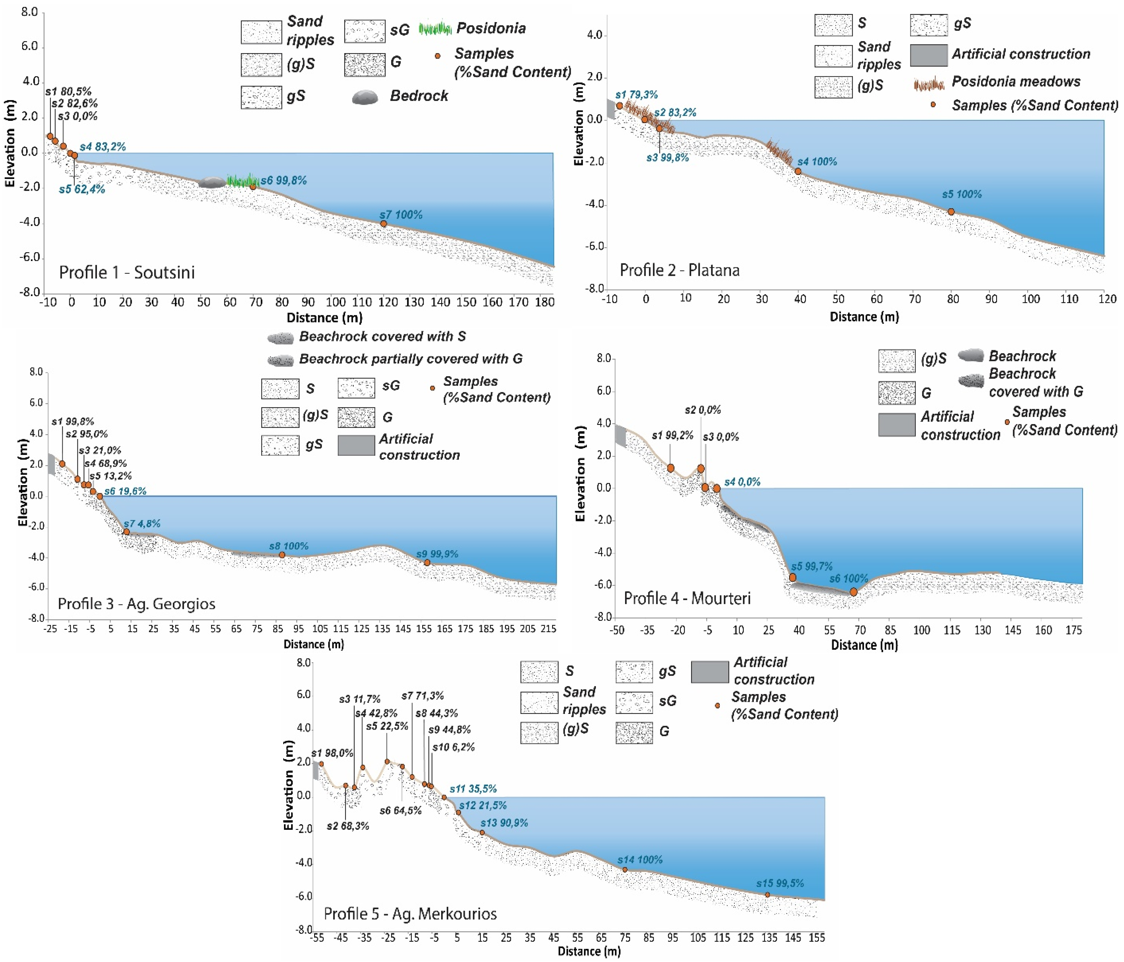
The subaerial profile P-1 (sub-sector A-II) from Kefala beach (see Figure 3) consists of mixed material that fines towards the foot of the cliff (sand > 90%). The beach face consists of gravelly sand (gS), while at its subaqueous part, seabed material changes from sandy gravel (sG) in the shoreface to slightly gravelly sand ((g)S) and, finally, sand (S), as it moves seaward. It is stated that the subaqueous part of the profile is located between bedrock outcrops, which are partially covered by meadows of Posidonia oceanica.
Profile 2 (Figure 3) was conducted at the northern part of Platana beach close to a protection construction (groyne). It is noted that the central and southern part of the Platana coastal front lacks a well-developed beach. In terms of grain size, the beach is generally sandy, both at the very narrow subaerial part (a few meters wide) and at its subaqueous part. The presence of this small beach to the south of the groyne is most likely related to the accumulation of sediment due to the longshore currents induced by the SE incoming waves.
Profile 3 at Agios Georgios beach (Figure 3) is delimited by a coastal road at its landward limit, the elevation of which is 2.5–3.0 m. The slope in this subaerial part, the width of which is ca. 20 m, has a slope of 12.5% slope, characterized by the presence of a well-formed berm at ca. 1 m above sea level, at a distance of 6 m from the shoreline. The shoreface consists of gravel material and maintains a slope of 16.5%, while seawards, the slope is rather smooth (<2.5%), reaching a water depth of 6 m at a distance of 220 m from the shoreline and consisting of mixed (sands, gravels) material at its greatest part. Beachrock formations—partially covered by gravel of variable size (Mz > 7 mm)—occur at a depth of ca. 2.5 m, while at greater depths up to about 4 m, they are either partially covered or outcrop from the generally sandy seabed. Further offshore, at a distance of 130 ± 10 m and a water depth of ca. 3 m, a sandy bar about 1.5 m high has been traced.
The subaerial part of profile 4, at Mourteri beach (Figure 3), has a width of ca. 45 m and extends between the shoreline and a small dune (height 1.5–1.8 m), which is bounded landwards by a coastal road. The beach zone includes also two berms at distances of 8.0 m and 2.5 m from the shoreline, with heights of about 1.0 m and 0.5 m, respectively. The beach sediment consists of gravel finning towards the dune toe. The shoreface is composed of gravel, while the shallower part of the foreshore (depth up to 2 m) also consists of gravel covering beachrock formations. From this depth to a depth of 5.5 m, the slope of the seabed increases from less than 17% to more than 20%. Beachrock formations (uncovered by sediment) are present between 5.5 m and 6.0 m depth (horizontal distance of ca. 30 m). The remaining part of the profile represents a sandy bottom with a gentle slope (1.5%).
Profile 5 at Agios Merkourios beach (Figure 3) is characterized by the widest subaerial beach maintaining > 60 m width, reaching an altitude of 2.0–2.5 m, at the foot of a small dune. Starting from the shoreline, four successive berms at ca. 7 m, 25 m, 35 m and 50 m are present as the result of wave runup induced by waves of different heights. It consists of mixed material with gravelly sand (gS) occupying the flattened parts of the berms and sandy gravel (sG) occupying their fronts. The active beach face and the upper part of the shoreface (depths < 2 m) bottom sediment consists of sandy gravel (sG), which fines seawards to become sandy with ripples at water depths > 3 m. Neither beachrock formations nor seaweed (e.g., Posidonia oceanica) have been observed in this profile.

4.3. Sediment Budget

Τhe beach sediment budget includes terrestrial (cliff erosion and rivers) and marine (longshore transport) fluxes. Therefore, considering that the three small rivers drain an inland area of approximately 235 km2, and assuming that the fluvial suspended sediment yield ranges between 140 and 250 tons/km2 [56,57], the coastal region receives an annual inflow of 44.1 ± 8.9 × 10³ tons. In addition, a bedload influx of about 9 × 10³ tons could also contribute to the sediment budget, as it potentially accounts for 10–30% of the total fluvial sediment load [58].
Coastal cliffs are likely to contribute significantly to the sediment budget. Considering that along the 34,900 km of the European Mediterranean rocky/cliffed coast, erosion contributes about 40 ± 22 × 106 tons/year [8], the ca. 18 km of the cliff coast under investigation may contribute annually an additional amount of 20.6 ± 11.3 × 10³ tons. Therefore, the total terrestrial sediment load may account for ca. 74 × 103 tons/year.
The calculation of the potential longshore sediment transport reveals a gross annual estimate of 10 to 130 × 103 tons/year (Table 4), with a southward direction in all sectors except sector A, where the direction is northeast. This transport rate exceeds the potential terrestrial inputs that account for ca. 74 × 103 tons/year.

4.4. Recent Coastal Evolution

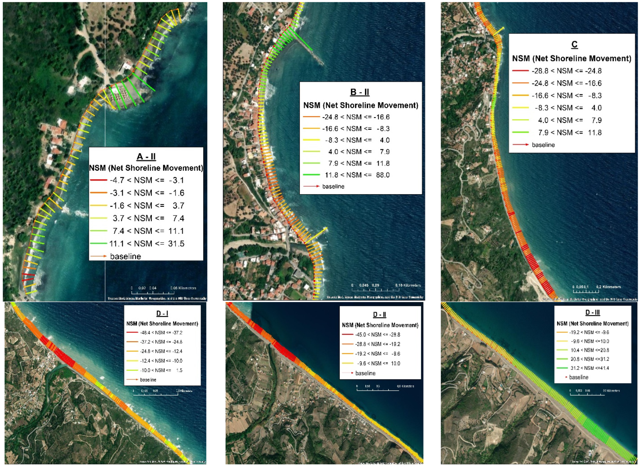
The application of the DSAS-NSM approach for the different sectors of the study area is presented in Figure 4, while the quantitative shoreline displacement for the period of 1945–2019 is summarized in Table 5. The Root Mean Square Error (RMSE) ranged between 0.2 m and 0.6 m (see also Table 5).

5. Discussion

5.1. Factors Controlling Coastal Evolution

During the Quaternary, the coastal zone under investigation underwent significant morphological changes mainly due to diastrophism, influenced by non-marine factors. Normal faults played a pivotal role, either aligning parallel to the coastline or intersecting diagonally. Today, the under investigation coastal landscape presents a mixture of morphological features, with sectors characterized by straightened coastlines owing to marine deposition, manifested as developed beach zones, and other sectors, particularly at either end, controlled by cliffs, either entirely devoid of or with a very narrow beach zone.
Morphotectonic processes extend back millions of years, while secondary processes such as cliff erosion and sediment transport have prominently influenced the landscape since the last transgression, especially since the last glacial maximum. In particular, the formation of modern beaches is the result of marine processes spanning the last 4–5 × 10³ years, a period corresponding to the gradual sea level rise of no more than 1 mm/year [1,3,4].
Nearshore morphodynamics are driven by the incoming waves and the associated nearshore currents. Higher incoming waves have the capacity to mobilize bottom sediments up to 12 m depth, while they break at depths less than 6 m, forming longshore bars. In addition, they are characterized by run-up values exceeding 2 m, resulting in the formation of berms at different elevations. Additionally, it is noteworthy to comment on the characterization of the beach configuration state. The A-II and B-II beach sectors are characterized as reflective (Ω < 1) when the significant wave height (upper 33%) is considered in the calculations, while the same sectors adopt a dissipative or intermediate state if the higher 10% of waves are considered. This finding is attributed to the topography of the beach face/upper shoreface topography (0–2 m water depth) in which—in the first case—the slope is high (13/%) and seabed material is gravelly, whilst—in the second case—the slope is reduced (2.4%) and the sediment is finer (mostly sand). However, for the smaller waves approaching from the E and SE, the difference is evident, as in the southern coastal sectors beach state remains reflective, in the central sector it remains intermediate, while in the northern sector, the beach state is dissipative for both wave sets.
The dissipative nature of beaches is indeed highly dependent on their formation, which is influenced by terrestrial sediment fluxes and long shore sediment transport. The total terrestrial sediment load is estimated to be about 74 × 103 tons/year, while the potential long shore sediment transport varies between 10 and 130 × 103 tonnes/year (see Table 4). Given the current state of the study area, which shows a negative trend of shoreline evolution with parts of the nearshore zone lacking unconsolidated sediment, it can be inferred that the initial formation of the beach in front of the cliff concluded much earlier and most likely before any significant human intervention (i.e., prior to the mid-1990s).

5.2. Coastal Evolution

The northern coastal sector (A) comprises two sub-sectors (see Figure 1): the northern sub-sector (A-I) with a W–E coastline orientation, and the southern sub-sector (A-II) constitutes a coastline trending NW–SW. Both sub-sectors are controlled by faults that intersect almost perpendicular to the coastline, having caused a tectonic uplift of more than 1–1.5 m, as revealed by the presence of a notch at Cape Kymi (Figure 5a) and the emergence of strongly tilted seafloor strata (Figure 5b).
The northern sub-sector (A-I) is essentially devoid of beach zones (Figure 5a), while the southern sub-sector (A-II) hosts a narrow beach zone developed basically in between seabed outcrops with sediment derived from coastal cliffs. In this sector, the longest beach zone (about 450 m long) is Soutsini beach (Figure 5c); it consists of mixed material (sand and gravel) finning towards the foot of the cliff (sand > 90%), while its shoreface consists of slightly gravelly sand ((g)S) with gravel < 10%. In general, sector A is rather stable or slightly retreating in response to northeastward longshore sediment transport and bedrock outcrops that trap nearshore sediment and dissipate incoming wave energy. Human influence is present in this sector, with several interventions evident on the cliff (e.g., cottages, roads, seawalls). Overall, the Soutsini beach appears to be currently under erosion, as shown in Figure 5d.
Sector B is extended from ca. 300 m north of the port of Kymi to the mouth of R. Melas, having a NNE–SSW coastline orientation (Figure 6a,b). The coastline is marked by the absence of well-developed beaches, but there is significant anthropogenic intervention, which mainly concerns the construction of the port of Kymi and the residential development of the town of Platana in the coastal front, including the installation of two groynes at both ends.
Apparently, as can be seen from the analyses of the evolution of the coastline, the presence of the harbor has not caused any significant changes to the nearby coastline, probably due to the lack of sediment inputs in the surrounding area. On the other hand, the coastal front of the town of Platana has undergone extensive erosion leading to the degradation of its beach that was extending over 20 m wide in the 1940s (Figure 6c). This erosion is attributed to the presence of the seawall that reflects wave energy in conjunction with the presence of a groyne in the southern area, which prohibits the northward longshore transport (during SE waves) of the sediments delivered by the R. Melas. On the other hand, south of the northern groyne a very narrow (a few meters wide) beach is present, developed by the accumulation of sediments (Figure 6d).
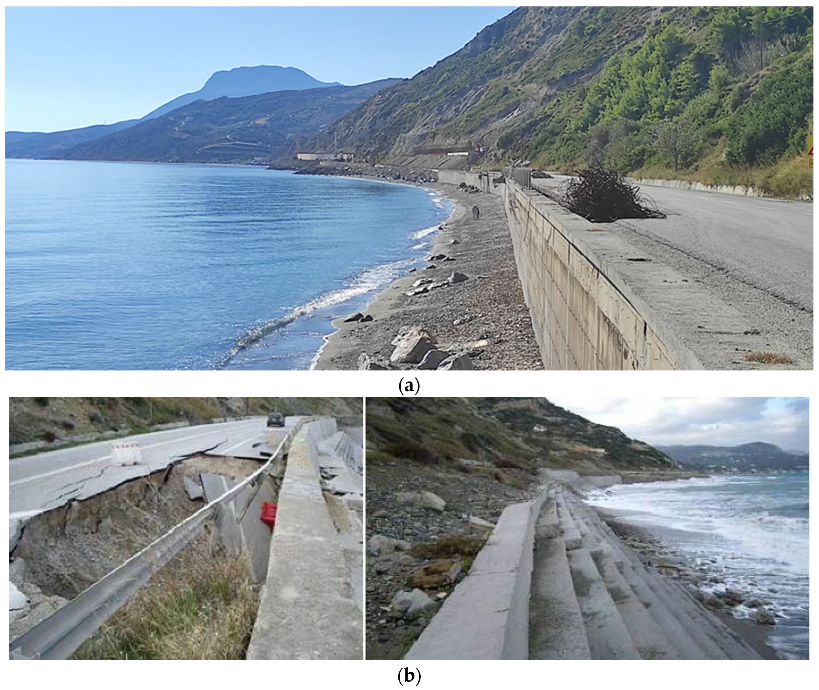
The coastal sector (C) is located between the mouths of R. Melas (north) and R. Manikiatis (south), having a NNE–SSW coastline orientation. The main anthropogenic intervention in this sector is the presence of the coastal road (Figure 7a) connecting the port of Kymi with the town of Oxilinthos (to the south), which is supported by a sea wall.
The coastal road has been constructed along the foot of the coastal cliff; prior to its construction, a narrow beach with a width of no more than 10 m was extending in front of the cliff. Nowadays, most of this narrow beach has eroded or exists temporarily, with a dependence on nearshore hydrodynamics. A narrow beach (width < 10 m) present at the southern part of sector C is composed of rather coarse material (Figure 7). In situ field observations showed that the shoreface (0–3 m water depth) is devoid of sediment and “covered” by boulders; this suggests that the construction of the coastal wall led to the reflection of the storm waves on the wall causing intensive sediment removal both to the south by longshore and to the sea by offshore sediment transport. In addition, as illustrated in the photographs in Figure 7b, the southern section of this coastal road has been partially damaged due to the failure of the stepped retaining wall; the latter was constructed to reinforce the base of the wall against incoming waves [36].
Coastal sector (D) extends from the mouth of the R. Manitiatis (north) to the headland adjacent to the small R. Rema, with a NW–SE coastline orientation; it is further divided into three sub-sectors (D-I, D-II and D-III).
The northern sub-sector (D-I) is characterized by a well-developed beach in front of a moderately sloping cliff (40°) (Figure 8a). The width of the beach gradually decreases towards its southern end. The greater width at its northern end is attributed to the sediments delivered by the river Manitiatis. The southern boundary is defined by a fault-controlled headland that slightly intrudes into the sea. At its base, beachrock’s presence provides protection from erosion (Figure 8c). The beach material is mostly sandy, while the presence of berms with a gravel front is associated with storm wave runup that exceeds 2 m. In the last few decades, this sector has undergone a moderate retreat, while some central and southern areas either remain stable or show a tendency to progradation; the latter phenomenon could also be linked to southward longshore transport of sediments.
The coastline of the second sub-sector (D-II), located south of the aforementioned headland, has the same orientation as sub-sector D-I, but shifts approximately 120 m inland. It has a well-developed beach, 40–50 m wide. Its northern part encompasses the alluvial valley of the R. Manikiatis, while its southern part is bordered landwards by a cliff, similar—in terms of face slope and lithology—to that of sub-sector D-I. One of the prominent features of this shoreline segment is the occurrence of beachrock “patches” along the beach face at regular intervals of 100–150 m (Figure 9). These beachrocks appear to act as artificial structures trapping sediment between them and, thus, supporting the stabilization of the beach. However, their presence suggests an earlier phase of beach retreat. Moreover, along profile P5 (placed between two successive beachrock “patches”), the presence of beachrock is also reported underwater up to a depth of approximately 4 m; herein, beachrocks are partially covered by sediments. Beachrock formations have been found at similar depths in the northern Cycladic Islands [4]: 3.6 ± 0.2 m (covering a period of ca. 2000–180 BC); 2.4 ± 0.2 m (dating from 146 BC to 400 AD); 1.3 ± 0.2 m (dated: 1200–1540 AD); and close to the surface −0.8 ± 0.1 m (dated: 1550–1650 AD). The deepest beachrock recorded in profile P5 was observed at a water depth of 5.0–5.5 m. This depth range is very similar to the depth of beachrock, which is approximately 5.00 ± 0.20 m deep and dates from 4200 BC to 2000 BC, as found at Poles and Mesa Steno (Andros Isl.), Kalafati (Mykonos Isl.) and Logaras (Paros Isl.) [4,59].
Sub-sector D-II displays a retreating northern section, with retreat distances exceeding 24 m; the retreating trend extends to over 35 m around the mouth of the R. Rema. Southwards, the retreat rates decrease and the final section tends to be more stable. This stabilization trend could be attributed to the overall longshore sediment transport, which is directed from north to south.
The third sub-sector (D-III) is situated between two fault-controlled headlands (Figure 10) with almost vertical slopes but different lithology. The northern promontory comprises Neogene clastic formations, while the southern promontory consists of Upper Triassic to Middle Jurassic limestone (Figure 2).
The beach attains its maximum width, reaching 60 m at its southern end. This widening is attributed to the presence of two small torrents on the north side of the two headlands, as well as the overall longshore sediment transport to the south. In contrast to sub-sector D-II, this area has no observable beachrock formations along the beach profile. The generally shallower beach profile suggests that any existing beachrocks may have been buried by sediments transported via longshore sediment transport, which is further evidenced by the overall trend of beach advance. Coastal sector (E) encompasses the coastline extending from the headland separating sectors D and E to the Punta promontory. This sector is characterized by the presence of a steeply sloping cliff made of Mesozoic limestones, which occasionally hosts small pocket beaches. These beaches are fed by material carried by small ephemeral streams (Figure 11).

6. Conclusions

The morphological evolution of the eastern coast of Evia Island is mainly influenced by neotectonic activity associated with two sets of intersecting fault systems. Secondary factors controlling the morphological state include sea level rise, particularly since the last glacial maximum (i.e., around 20,000 years ago), terrestrial sediment fluxes and nearshore hydrodynamics. The presence of beachrocks up to depths of 5–6 m indicated periods of relatively stable sea level, interrupted by episodic tectonic movements. Given the limited tidal range, nearshore hydrodynamics driven by incoming waves play a crucial role in beach formation and evolution.
Human interventions since the mid-19th century, such as the construction of the port of Kymi, have influenced the evolution of the coastline, especially in areas bounded by coastal cliffs. Interestingly, the presence of the Kymi port does not seem to be correlated with shoreline displacements. On the contrary, the application of protective structures such as seawalls and groynes at Platana beach, along with the presence of the coastal road and the seawall in sector C, led to increased erosion in these beach zones.
In conclusion, the northern and southern end sectors (A and E) are primarily influenced by geotectonics, while sector B in the north, although controlled also by tectonism, has been more recently impacted by human interventions. This intervention seems to dictate the current state of sector C, while the central and southern sector D seems to have developed naturally, driven by Holocene fault activity and sedimentary processes. Since the mid-1990s, the sectors subjected to minimal human intervention tend to show stability or slight progradation, while extensive shoreline retreat is associated with coastal human-made constructions.

Author Contributions

Conceptualization, S.P., C.A. and A.K.; methodology, S.P., A.K. and S.L.; software, S.L. and A.K.; validation, S.P., A.K. and C.A.; formal analysis, S.L., A.K. and S.P.; investigation, S.P., C.A. and S.L.; resources, S.P.; data curation, S.L., A.K. and S.P.; writing—original draft preparation, S.P. and A.K.; writing—review and editing, S.P.; visualization, S.L. and A.K.; supervision, S.P.; project administration, S.P.; funding acquisition, S.P. All authors have read and agreed to the published version of the manuscript.

Funding

The authors S. Poulos and A. Karditsa were supported by the research project ILIDA-KIT, funded by the General Secretariat for Research and Innovation of the Hellenic Republic Ministry of Development (T2EDK-02795).

Data Availability Statement

Data are contained within the article.

Conflicts of Interest

The authors declare no conflicts of interest.

Appendix A

Table A1. Grain size characteristics of the surficial sediment samples obtained from different elevations (ELV) along the five profiles (P1–P5) (for locations, see Figure 1).
SectorsSamplesELV (m)Mz (mm)D50 (mm)S (%)Type
A-II
(Profile 1)
s11.48.2668.9422.7G
s21.26.5046.2400.6G
s30.813.05021.2340.0G
s40.414.22713.3900.0G
s50.29.0709.3160.0G
s60.04.5254.7370.4G
s7−4.20.3180.33499.9S
s8−6.00.2340.23399.9S
B-I
(Profile 2)
s10.50.3500.35279.3gS
s20.00.6700.44583.2gS
s3−0.60.2500.24499.8(g)S
s4−2.00.1810.181100S
s5−4.00.1950.190100S
D-III
(Profile 3)
s12.10.6050.64199.8(g)S
s21.10.4900.48195.0gS
s30.74.22720.97221.0sG
s40.71.7430.85168.9sG
s50.34.9425.05913.2G
s60.04.1234.54519.6G
s7−2.36.99123.2494.8G
s8−3.80.2990.317100S
s9−6.00.3900.37299.9(g)S
D-II
(Profile 4)
s13.30.8560.78287.8gS
s22.25.61116.68634.7sG
s31.74.7173.03622.3sG
s40.96.5195.7577.5G
s50.62.2072.02549.3sG
s60.67.7297.8980.2G
s70.33.7543.3710.2G
s80.02.7522.60332.7sG
s9−2.35.2024.3337.4G
s10−4.00.5720.61199.8(g)S
s11−6.00.3200.335100.0S
D-II
(Profile 5)
s12.00.9731.01898.0(g)S
s20.72.1901.37868.3sG
s30.65.1643.48811.7G
s41.81.6572.22342.8sG
s52.16.83815.86322.5sG
s61.81.3561.09164.5sG
S71.21.7161.61771.3gS
s80.82.9852.32344.3sG
s90.72.0682.13444.8sG
s100.65.5485.7306.2G
s110.02.4802.61225.5sG
s12−0.94.4794.21421.5sG
s13−2.10.6690.85190.9gS
s14−4.30.4540.450100.0S
s15−5.80.1520.14399.5S
Notes: Key. G: gravel, S: sand; sG: sandy gravel; (g)S: slight gravely sand; gS: gravely sand.

References

  1. Lambeck, K. Sea-level change and shore-line evolution in Aegean Greece since Upper Palaeolithic time. Antiquity 1996, 70, 588–611. [Google Scholar] [CrossRef]
  2. Lambeck, K.; Purcell, A. Sea-level change in the Mediterranean Sea since the LGM: Model predictions for tectonically stable areas. Quat. Sci. Rev. 2005, 24, 1969–1988. [Google Scholar] [CrossRef]
  3. Poulos, S.E.; Ghionis, G.; Maroukian, H. Sea-level rise trends in the Attico–Cycladic region (Aegean Sea) during the last 5000 years. Geomorphology 2009, 107, 10–17. [Google Scholar] [CrossRef]
  4. Kolaiti, E.; Mourtzas, N. Late Holocene relative sea-level changes and coastal landscape readings in the island group of Mykonos, Delos, and Rheneia (Cyclades, Greece). Mediterr. Geosci. Rev. 2023, 5, 99–128. [Google Scholar] [CrossRef]
  5. Woodroffe, C.D.; Thom, B.G.; Chappell, J. Development of widespread mangrove swamps in mid-Holocene times in northern Australia. Nature 1985, 317, 711–713. [Google Scholar] [CrossRef]
  6. Stapor, F.W., Jr.; Stone, G.W. A new depositional model for the buried 4000 yr BP New Orleans barrier: Implications for sea-level fluc tuations and onshore transport from a nearshore shelf source. Mar Geol. 2004, 204, 215–234. [Google Scholar] [CrossRef]
  7. Harvey, N.; Nicholls, R. Global sea-level rise and coastal vulnerability. Sustain. Sci. 2008, 3, 5–7. [Google Scholar] [CrossRef]
  8. Regard, V.; Prémaillon, M.; Dewez, T.J.B.; Carretier, S.; Jeandel, C.; Godderis, Y.; Bonnet, S.; Schott, J.; Pedoja, K.; Martinod, J.; et al. Rock coast erosion: An overlooked source of sediments to the ocean. Europe as an example. Earth Planet. Sci. Lett. 2022, 579, 117356. [Google Scholar] [CrossRef]
  9. Dawson, R.J.; Dickson, M.E.; Nicholls, R.J.; Hall, J.W.; Walkden, M.J.; Stansby, P.K.; Mokrech, M.; Richards, J.; Zhou, J.; Milligan, J.; et al. Integrated analysis of risks of coastal flooding and cliff erosion under scenarios of long term change. Clim. Change 2009, 95, 249–288. [Google Scholar] [CrossRef]
  10. Budetta, P.; Galietta, G.; Santo, A. A methodology for the study of the relation between coastal cliff erosion and the mechanical strength of soils and rock masses. Eng. Geol. 2000, 56, 243–256. [Google Scholar] [CrossRef]
  11. Kirk, R.M.; Komar, P.D.; Allan, J.C.; Stephenson, W.J. Shoreline erosion on Lake Hawea, New Zealand, caused by high lake levels and storm-wave runup. J. Coast. Res. 2000, 16, 346–356. [Google Scholar]
  12. Hapke, C.J.; Reid, D.; Richmond, B. Rates and trends of coastal change in California and the regional behavior of the beach and cliff system. J. Coast. Res. 2009, 25, 603–615. [Google Scholar] [CrossRef]
  13. Earlie, C.; Masselink, G.; Russell, P. The role of beach morphology on coastal cliff erosion under extreme waves. Earth Surf. Process. Landf. 2018, 43, 1213–1228. [Google Scholar] [CrossRef]
  14. Mushkin, A.; Katz, O.; Porat, N. Overestimation of short-term coastal cliff retreat rates in the eastern Mediterranean resolved with a sediment budget approach. Earth Surf. Process. Landf. 2019, 44, 179–190. [Google Scholar] [CrossRef]
  15. Barkai, O.; Katz, O.; Mushkin, A.; Goodman-Tchernov, B.N. Long-term retreat rates of Israel’s Mediterranean Sea cliffs inferred from reconstruction of eroded archaeological sites. Geoarchaeology 2018, 33, 314–327. [Google Scholar] [CrossRef]
  16. Sytnik, O.; Del Río, L.; Greggio, N.; Bonetti, J. Historical shoreline trend analysis and drivers of coastal change along the Ravenna coast, NE Adriatic. Environ. Earth Sci. 2018, 77, 779. [Google Scholar] [CrossRef]
  17. Giuliano, J.; Dewez, T.J.; Lebourg, T.; Godard, V.; Prémaillon, M.; Marçot, N. Mapping Coastal Erosion of a Mediterranean Cliff with a Boat-Borne Laser Scanner: Performance, Processing, and Cliff Erosion Rate. In 3D Digital Geological Models: From Terrestrial Outcrops to Planetary Surfaces; Wiley: Hoboken, NJ, USA, 2022; pp. 109–132. [Google Scholar]
  18. Theodore, P.; Thomas, H.; Adonis, V.; Theophanis, K.; Emmanouel, O.; Charalampos, D. Erosion status of a sea cliff promontory bounding an ecologically important beach. J. Coast. Conserv. 2020, 24, 39. [Google Scholar] [CrossRef]
  19. Vandarakis, D.; Poulos, S.; Karditsa, A.; Petrakis, S.; Alexandrakis, G.; Malliouri, D.; Hatiris, G.-A.; Moraitis, V.; Kikaki, K.; Anagnostou, C.; et al. Geomorphology and Dynamics of the Aegean Coasts. In The Handbook of Environmental Chemistry; Springer: Berlin/Heidelberg, Germany, 2024. [Google Scholar] [CrossRef]
  20. Dornbusch, U.; Williams, R.B.; Moses, C.A.; Robinson, D.A. Foreshore narrowing along the coast of southeast England, UK—A reevaluation. J. Coast. Res. 2008, 24, 14–24. [Google Scholar] [CrossRef]
  21. Lee, E.M. Coastal cliff behaviour: Observations on the relationship between beach levels and recession rates. Geomorphology 2008, 101, 558–571. [Google Scholar] [CrossRef]
  22. Sunamura, T. Processes of sea cliff and platform erosion. In Handbook of Coastal Processes and Erosion; Chapter 12; Komar, P.D., Ed.; CRC Press: Boca Raton, FL, USA, 2018. [Google Scholar]
  23. Terefenko, P.; Giza, A.; Paprotny, D.; Kubicki, A.; Winowski, M. Cliff retreat induced by series of storms at Międzyzdroje (Poland). J. Coast. Res. 2018, 85, 181–185. [Google Scholar] [CrossRef]
  24. Vousdoukas, M.I.; Velegrakis, A.F.; Plomaritis, T.A. Beachrock occurrence, characteristics, formation mechanisms and impacts. Earth-Sci. Rev. 2007, 85, 23–46. [Google Scholar] [CrossRef]
  25. Danjo, T.; Kawasaki, S. Characteristics of Beachrocks: A Review. Geotech. Coast. Eng. 2014, 32, 215–246. [Google Scholar] [CrossRef]
  26. Kelletat, D. Beachrock as sea-level indicator? Remarks from a geomorphological point of view. J. Coast. Res. 2006, 22, 1555–1564. [Google Scholar] [CrossRef]
  27. Desruelles, S.; Fouache, É.; Ciner, A.; Dalongeville, R.; Pavlopoulos, K.; Kosun, E.; Coquinot, Y.; Potdevin, J.L. Beachrocks and sea level changes since Middle Holocene: Comparison between the insular group of Mykonos–Delos–Rhenia (Cyclades, Greece) and the southern coast of Turkey. Glob. Planet. Change 2009, 66, 19–33. [Google Scholar] [CrossRef]
  28. Eurosion. “Coastal Erosion—Evaluation of the Need for Action” Directorate General Environment, European Commission [Research Programme for the Erosion in Europe], 2004. Available online: https://home-affairs.ec.europa.eu/whats-new/evaluations-and-impact-assessments_en (accessed on 18 April 2024).
  29. Pranzini, E.; Wetzel, L.; Williams, A.T. Aspects of coastal erosion and protection in Europe. J. Coast. Conserv. 2015, 19, 445–459. [Google Scholar] [CrossRef]
  30. GNRAC (Gruppo Nazionale per la Ricerca sull’ Ambiente Costiero). Lo stato dei litorali in Italia. Studi Costieri 2006, 10, 3–172. [Google Scholar]
  31. European Commission. The Economics of Climate Change Adaptation in EU Coastal Areas; Final Report; Policy Research Corporation Belgium: Brussels, Belgium, 2009; p. 153. [Google Scholar]
  32. Alexandrakis, G.; Karditsa, A.; Poulos, S.; Ghionis, G.; Kampanis, N.A. An assessment of the vulnerability to erosion of the coastal zone due to a potential rise of sea level: The case of the Hellenic Aegean coast. In Environmental Systems, Encyclopedia of Life Support Systems (EOLSS); Sydow, I., Ed.; Developed under the Auspices of the UNESCO; Eolss Publishers: Oxford, UK, 2010. [Google Scholar]
  33. Magoon, O.T.; Edge, B.L.; Stone, K.E. The impact of anthropogenic activities on coastal erosion. In Proceedings of the 27th International Conference on Coastal Engineering, Sydney, Australia, 16–21 July 2000. [Google Scholar]
  34. Williams, A.T.; Rangel-Buitrago, N.; Pranzini, E.; Anfuso, G. The management of coastal erosion. Ocean. Coast. Manag. 2018, 156, 4–20. [Google Scholar] [CrossRef]
  35. Abualhin, K. Short-term analysis of coastal erosion among human intervention and sea level rise. J. Coast. Conserv. 2022, 26, 75. [Google Scholar] [CrossRef]
  36. Ilia, I. Engineering Geological Features of Marls in the Wide Area of Kymi, Euboea, Their Impact on Construction Problems and Their Treatment. Ph.D. Thesis, National Technical University of Athens, School of Mining and Metallurgical Engineering, Athens, Greece, 2013; p. 328. [Google Scholar]
  37. IGME. Geological Map of Kymi (1:50,000); Institute for Groundwater Mineral Exploration: Athens, Greece, 1989. [Google Scholar]
  38. Koumantakis, I.; Rozos, D.; Markantonis, K.; Ilia, I.; Tsagaratos, P. Landslide Phenomena of Kymi Municipality. Research Program founded by the Prefecture of Euboea Island, 2008. Available online: https://scholar.google.com.hk/scholar?hl=zh-CN&as_sdt=0,5&q=Landslide+Phenomena+of+Kymi+Municipality.+Research+Program+funded+by+the+Prefecture+of+Euboea+Island (accessed on 18 April 2024).
  39. Ring, U.; Glodny, J.; Will, T.; Thomson, S. An Oligocene extrusion wedge of blueschist-facies nappes on Evia, Aegean Sea, Greece: Implications for the early exhumation of high-pressure rocks. J. Geol. Soc. 2007, 164, 637–652. [Google Scholar] [CrossRef]
  40. Ganas, A.; Drakatos, G.; Pavlides, S.B.; Stavrakakis, G.N.; Ziazia, M.; Sokos, E.; Karastathis, V.K. The 2001 Mw ¼ 6:4 Skyros earthquake, conjugate strike-slip faulting and spatial variation in stress with the central Aegean Sea. J. Geodyn. 2005, 39, 61–77. [Google Scholar] [CrossRef]
  41. Tsimplis, M.N. Tidal oscillations in the Aegean and Ionian Seas. Estuar. Coast. Shelf Sci. 1994, 39, 201–208. [Google Scholar] [CrossRef]
  42. CERC (Coastal Engineering Research Center). Shore Protection Manual, 4th ed.; U.S. Army Corp of Engineers, U.S. Government Printing Office: Washington, DC, USA, 1984.
  43. Goda, Y. Random seas and design of maritime structures. In Advanced Series on Ocean Engineering, 2nd ed.; World Scientific Publishing: Singapore, 2000; Volume 15. [Google Scholar]
  44. Hallermeyer, R.J. A profile zonation for seasonal sand beaches from wave climate. Coast. Eng. 1981, 4, 253–277. [Google Scholar] [CrossRef]
  45. Kraus, N.C.; Larson, M. Beach Profile Change Measured in the Tank for Large Waves 1956–1957 and 1962; Coastal Engineering Research Center: Vicksburg, MI, USA, 1988. [Google Scholar]
  46. Rattanapitikon, W.; Shibayama, T. Breaking wave formulas for breaking depth and orbital to phase velocity ratio. Coast. Eng. J. 2006, 48, 395–416. [Google Scholar] [CrossRef]
  47. Iribarren, R.; Nogales, C. Protection des Ports; Section II-4; XVII International Navigation Congress: Lisbon, Portugal, 1949. [Google Scholar]
  48. Short, A.D. The role of wave height, period, slope, tide range and embaymentisation in beach classifications: A review. Rev. Chil. Hist. Nat. 1996, 69, 589–604. [Google Scholar]
  49. Van Rijn, L.C. Principles of Sediment Transport in Rivers, Estuaries and Coastal Seas; Aqua Publications: Blokzijl, The Netherlands, 1993. [Google Scholar]
  50. Atkinson, A.L.; Power, H.E.; Monra, T.; Hammond, T.; Callaghan, D.P.; Baldock, T.E. Assessment of runup predictions by empirical models on non-truncated beaches on the southeast Australian coast. Coast. Eng. 2017, 119, 15–31. [Google Scholar] [CrossRef]
  51. Mase, H. Random Wave Runup Height on Gentle Slope. J. Waterw. Port Coast. Ocean. Eng. 1989, 115, 649–661. [Google Scholar] [CrossRef]
  52. Folk, R. Petrology of Sedimentary Rocks; Hemphill Publishing Company: Austin, TX, USA, 1980. [Google Scholar]
  53. Blott, S.J.; Pye, K. GRADISTAT: A grain size distribution and statistics package for the analysis of unconsolidated sediments. Earth Surf. Process. Landf. 2001, 26, 1237–1248. [Google Scholar] [CrossRef]
  54. Himmelstoss, E.A.; Henderson, R.E.; Farris, A.S.; Kratzmann, M.G.; Bartlett, M.K.; Ergul, A.; McAndrews, J.; Cibaj, R.; Zichichi, J.L.; Thieler, E.R. Digital Shoreline Analysis System; Version 6.0; U.S. Geological Survey: Reston, VA, USA, 2024. [CrossRef]
  55. Armaroli, C.; Ciavola, P.; Balouin, Y.; Gatti, M. An integrated study of shoreline variability using GIS and ARGUS techniques. J. Coast. Res. 2006, 39, 473–477. [Google Scholar]
  56. Poulos, S.E. River systems and their water and sediment fluxes towards the marine regions of the Mediterranean Sea and Black Sea earth system. An overview. Mediterr. Mar. Sci. 2019, 20, 549–565. [Google Scholar] [CrossRef]
  57. Woodward, J.C. Patterns of erosion and suspended sediment yield in Mediterranean river basins. In Sediment and Water Quality in River Catchments; Foster, I.D.L., Gurnell, A.M., Webb, B.W., Eds.; John Wiley & Sons Ltd.: Hoboken, NJ, USA, 1995; pp. 365–389. [Google Scholar]
  58. Poulos, S.E.; Collins, M.B. Fluviatile sediment fluxes to the Mediterranean Sea: A quantitative approach and the influence of dams. Geol. Soc. 2002, 191, 227–245. [Google Scholar] [CrossRef]
  59. Mourtzas, N.L. Palaeogeographic reconstruction of the coast of ancient Andros. In Palaiopolis, Andros: Thirty Years of Excavation Research; Palaiokrassa-Kopitsa; Kaïreios Library: Andros, Greece, 2018; pp. 56–66. Available online: https://scholar.google.com.hk/scholar?hl=zh-CN&as_sdt=0%2C5&q=Palaeogeographic+++reconstruction+++of+++thecoast+++of+++ancient+++Andros.&btnG= (accessed on 18 April 2024).
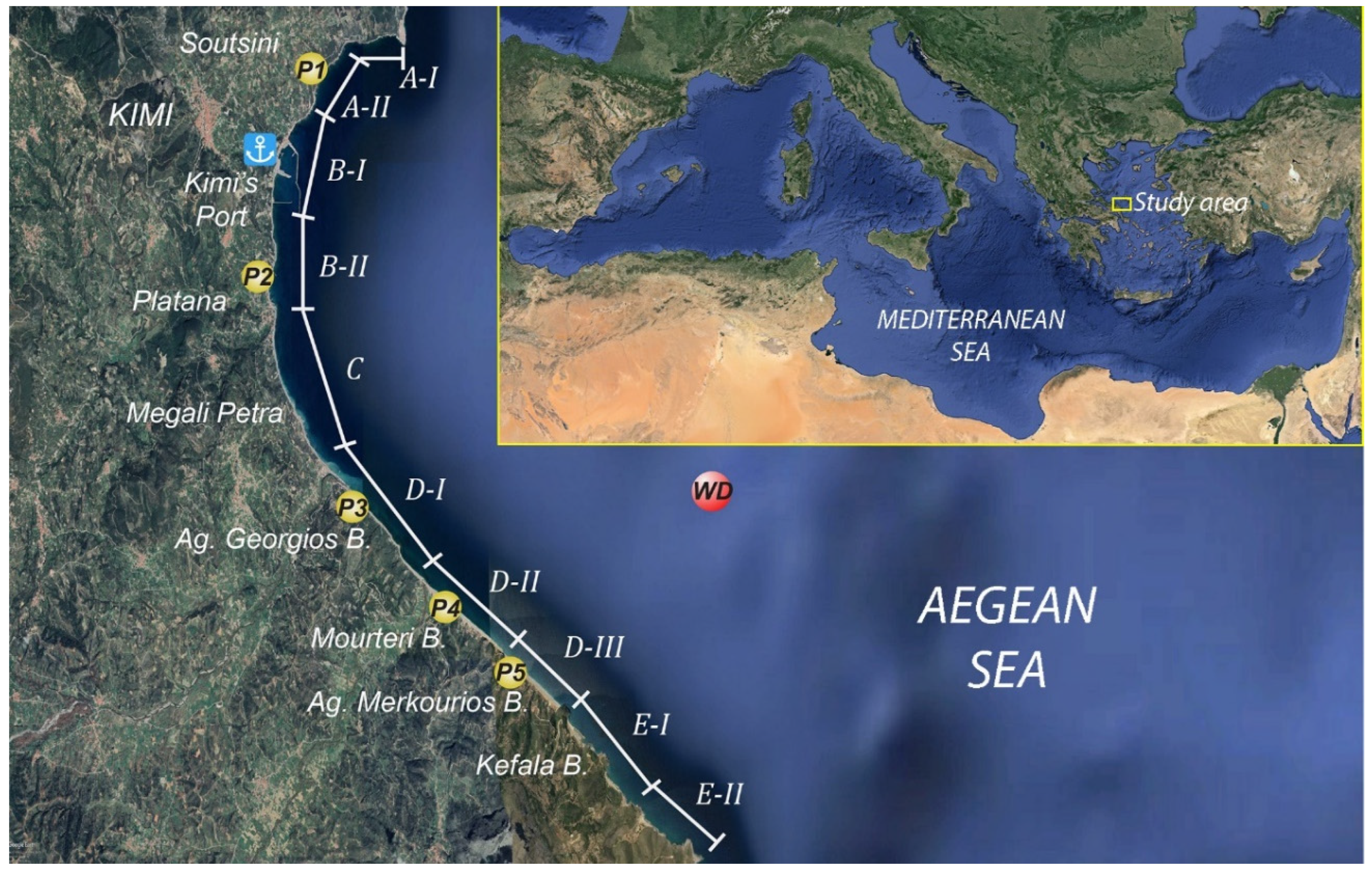
Figure 1. Area under investigation, illustrating the different coastal sectors (A–E), the positions of morphological profiles (P1–P5) normal to the coastline and the offshore position of wave data (WD) (background image source: Google Earth, 2019).
Water 16 01622 g001
Figure 2. Topographic, bathymetric and geological map of the study area.
Water 16 01622 g002
Figure 3. Beach profiles (1–5) normal to shoreline, showing morphology and sediment texture (for profile locations, see Figure 1).
Water 16 01622 g003
Figure 4. The results of shoreline spatial displacement between 1945 and 2019.
Water 16 01622 g004
Figure 5. Photos from (a) a sea notch close to the Kymi promontory, (b) seabed outcropping strata at Soutsini beach, (c) the cliff face and the Soutsini beach in front of it, and (d) appearance of the root system of a tree, indicating removal of beach (sandy) material.
Water 16 01622 g005
Figure 6. (a) A bathymetric map of the Platana town coastal front, (b) photo of its central part, (c,d) historical photos from the 1940′s and 1960’s.
Water 16 01622 g006
Figure 7. (a) Photo (October 2023) of the coastal road/seawall facing southwards, (b) photos of the seawall failure in 2011 (abstracted from Ilia [36]).
Water 16 01622 g007
Figure 8. Photos (facing southwards) from the sub-sector D-I: (a) beach zone in front of the cliff at the northern part (b) and at its southern part, and the beachrocks at the foot of the headland (c).
Water 16 01622 g008
Figure 9. (a) Successive beachrock patches along the shoreline of sub-sector D-II; (b) beachrock “patch”.
Water 16 01622 g009
Figure 10. Photos from the two headlands that confronted the beach zone of sub-sector D-III, which evidences the difference in beach material, changing from sandy towards the north end (photo (a)) to gravelly towards the south end (photo (b)).
Water 16 01622 g010
Figure 11. A Google Earth satellite image (2019) presenting coastal configuration of sector E.
Water 16 01622 g011
Table 1. Wave characteristics of the significant wave height and period for the 1/3, 1/10 and 1/100 highest incoming offshore waves from the total arc and the predominant directions.
H
(m)
T
(s)
Dir (deg)f
(%)
Hb
(m)
db
(m)
Total arc(1/3)0.863.7716.0323.310.910.87
(1/10)2.876.4020.296.272.844.29
(1/100)5.687.9920.980.795.437.71
N
(0° ± 22.5°)
(1/3)0.743.557.617.040.850.75
(1/10)2.355.8516.36.892.563.65
(1/100)4.997.5918.20.915.457.76
NE
(45° ± 22.5°)
(1/3)0.993.9530.54.851.131.01
(1/10)3.126.6129.61.953.404.84
(1/100)5.958.1027.10.246.499.23
E
(90° ± 22.5°)
(1/3)0.242.1890.30.830.270.24
(1/10)0.342.4197.30.390.370.53
(1/100)1.324.0077.30.051.442.05
SE
(135° ± 22.5°)
(1/3)0.442.86142.94.080.500.45
(1/10)1.474.70148.20.741.592.26
(1/100)3.816.16139.10.104.145.89
Table 2. The estimated values (in meters) for closure depth (hc) and wave runup (maximum and 2%) of the highest 10% and 1% of the incoming offshore waves from the dominant directions.
(1/100)(1/10)
hSR2%RmaxR2%Rmax
N11.31.31.60.60.9
NE13.41.52.20.81.2
E3.00.40.50.10.1
SE8.61.01.10.40.6
Table 3. Classification of the foreshore zone of the various sectors for the different directions of the incoming waves, according to Short’s Ω parameter [48]—[dissipative (Ω > 6), intermediate (1 < Ω < 6) and reflective Ω < 1].
ΝΝΕESE
Ω[1/3]Ω[1/10]Ω[1/3]Ω[1/10]Ω[1/3]Ω[1/10]Ω[1/3]Ω[1/10]
A-II (Ρ1)(1–6)>6>6>6(1–6)(1–6)(1–6)>6
B-II (Ρ2)>6>6>6>6(1–6)(1–6)>6>6
D-I (Ρ3)<1>6<1(1–6)<1<1<1<1
D-II (Ρ4)<1>6<1(1–6)<1<1<1<1
D-III (Ρ5)<1(1–6)(1–6)(1–6)<1<1<1<1
Note: values Ω[1/3] and Ω[1/10] refer to beach face (depths < 2 m) and shoreface, respectively.
Table 4. Estimates of the potential longshore sediment transport at the coastal sectors (A–D) (positive direction is taken from north to south).
Coastal Sectors (Beaches)Qm
(103 tons/year)
Water 16 01622 i001
A-II (Soutsini)−10
B-II (Platana)+105
C    (Petra)+130
D    (Ag. Georgios, Ag. Merkourios, Mourteri)+99
Table 5. Comments for coastline displacement, produced by the DSAS-NSM approach.
Coastal SectorCoastline Displacement
A-II40% (northern part) slightly retreated (2–4 m, maximum 6 m); 60% (southern part) prograde by 4–10 m (RMSE = 0.58 m).
B-IIAbout 70% is under erosion with a mean retreat of 6 m (maximum 12 m); the other 30% shows a small progradation (>4 m), which locally exceeds the 10 m (RMSE = 0.24 m).
C¾ retreating up to 20 m (mean value = 11 m); the other ¼ is either rather stable and/or prograde by < 6 m (southern end) (RMSE = 0.24 m).
D-I87% (central and southern part) retreat by no more than 15 m (on average), while 8% is rather stable and 5% prograde by a few meters (RMSE = 0.52 m).
D-IIAbout 60% (northern part) retreats on average by 13–15 m (maximum values = 25 m); its central part (18%) has retreated by > 18 m, while its southern part (22%) is rather stable or slightly prograde (RMSE = 0.38 m).
D-IIIThe northern part (40%) is rather stable or slightly retreating; its central/southern part progrades with an average value of 15 m (maximum 20 m), while its southern end presents the largest progradation of 36 m and a mean value of 19 m (RMSE = 0.38 m).
Disclaimer/Publisher’s Note: The statements, opinions and data contained in all publications are solely those of the individual author(s) and contributor(s) and not of MDPI and/or the editor(s). MDPI and/or the editor(s) disclaim responsibility for any injury to people or property resulting from any ideas, methods, instructions or products referred to in the content.