
Hydrological Response of Bamboo Plantations on Soil–Water Dynamics in Humid and Semi-Arid Coastal Region of Kenya
 , , , , and
Abstract
:1. Introduction
2. Materials and Methods
2.1. Experimental Sites
2.2. Soils and Climate
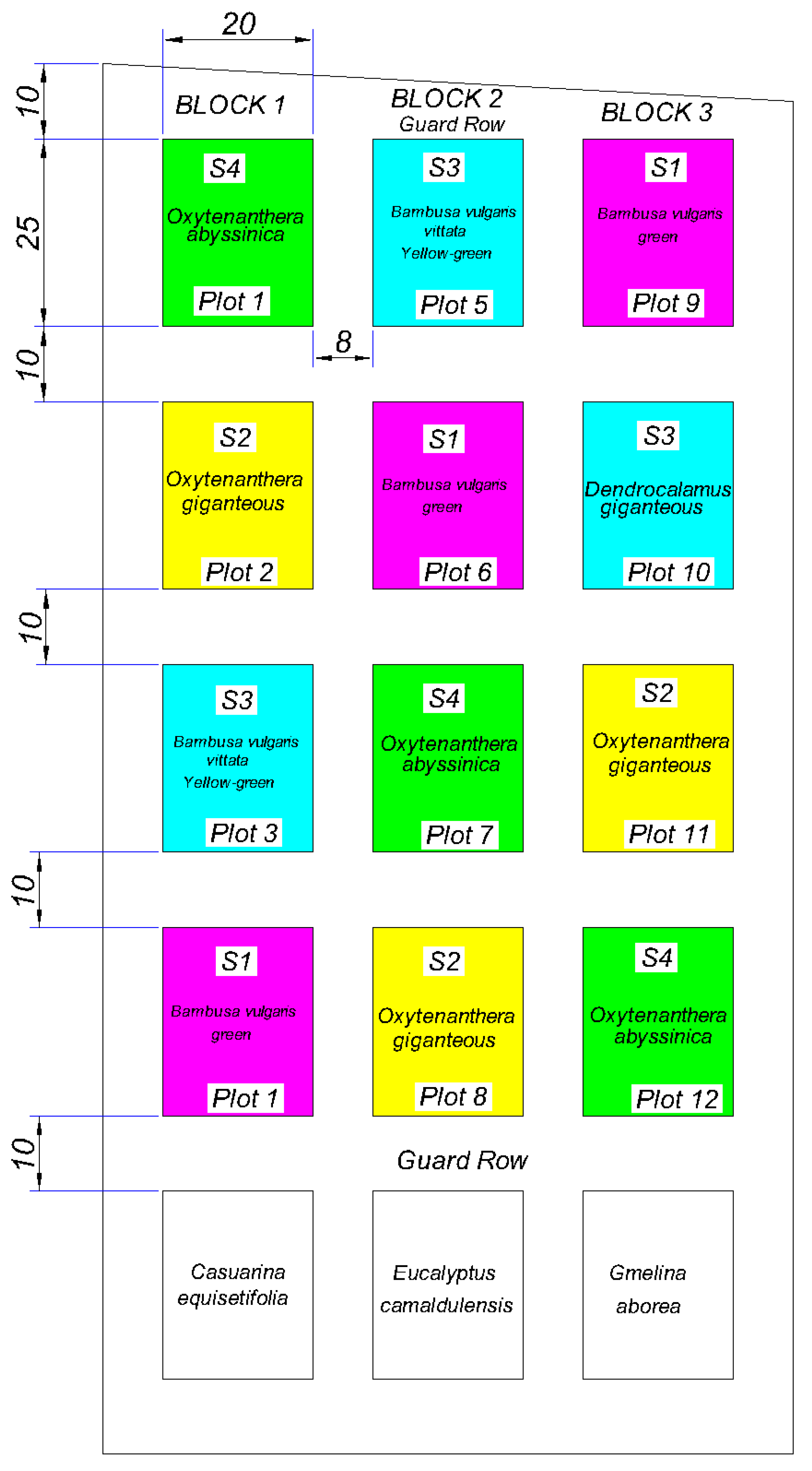
2.3. Description of Bamboo Plantations and Species
2.4. Measurement of Water Infiltration in Soils under Bamboo Plantations
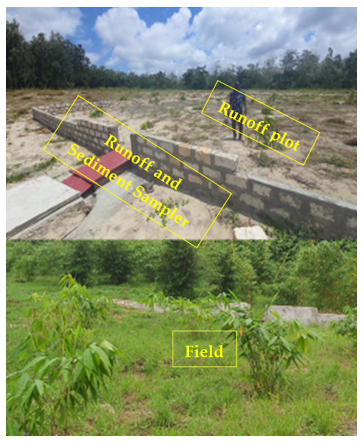
2.5. Collection and Quantification of Runoff and Soil Loss on Bamboo Plantations
3. Results
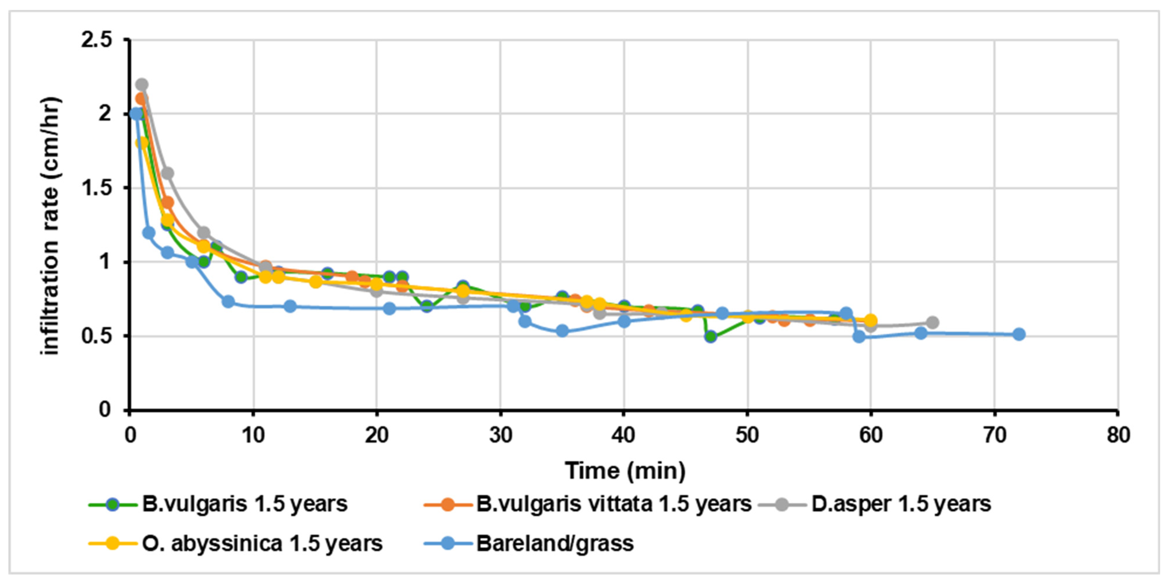
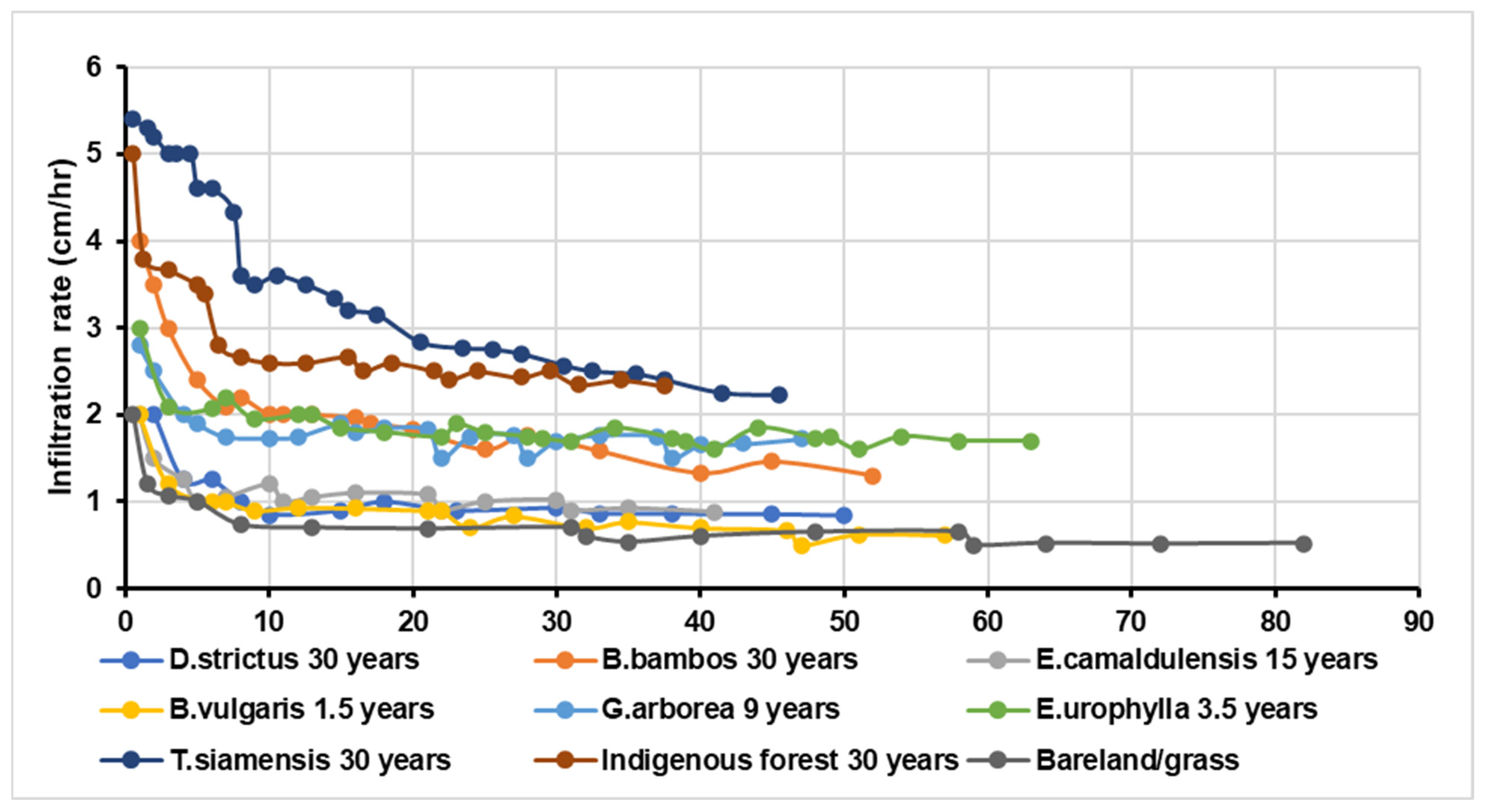
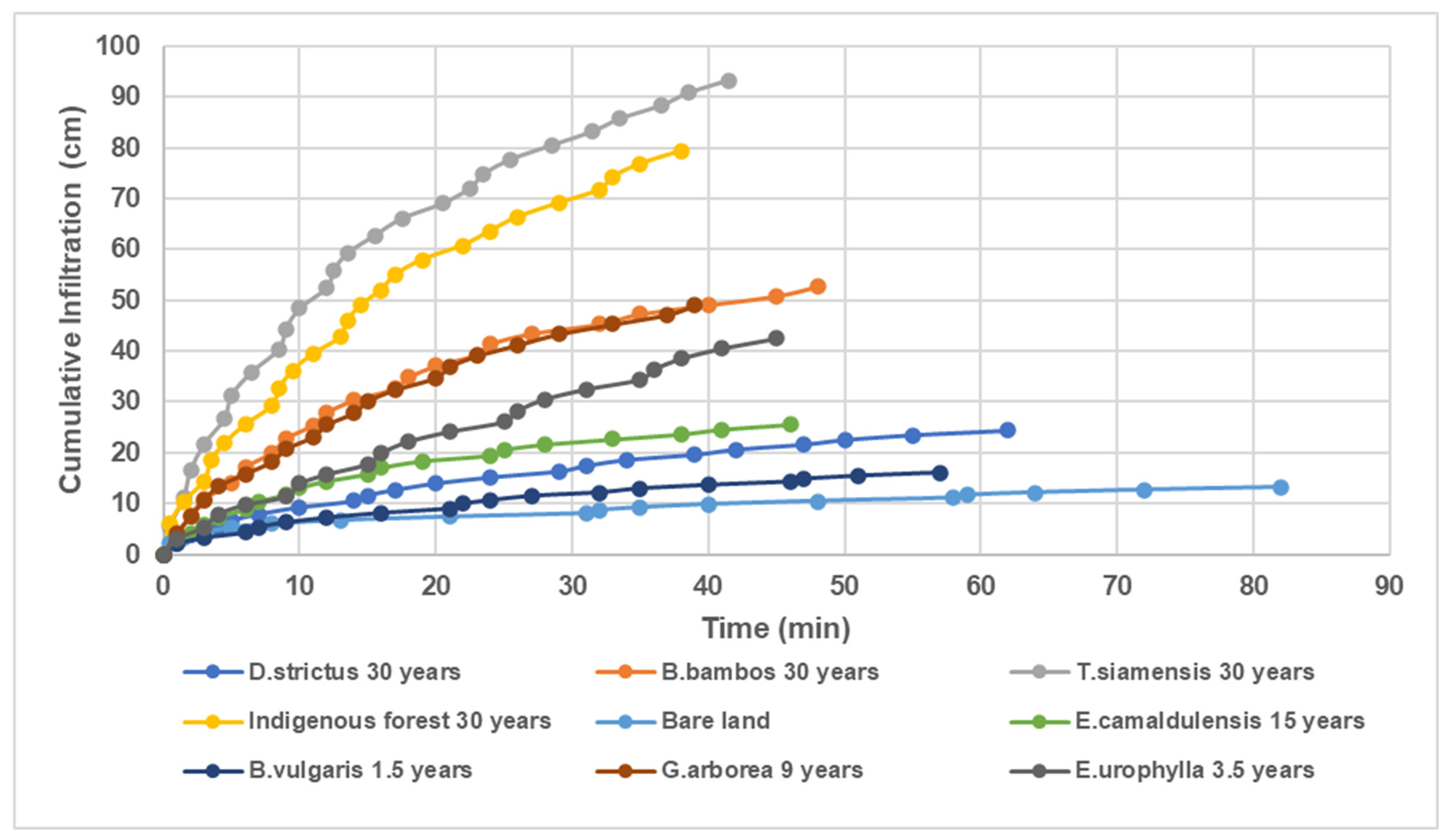
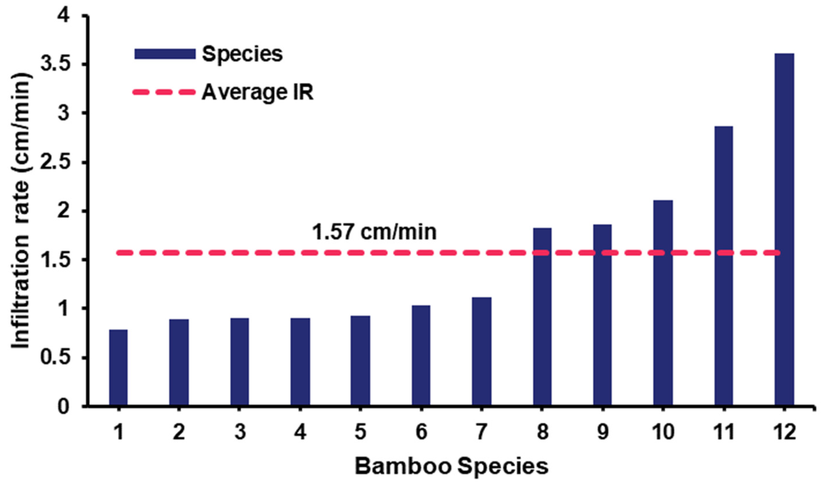
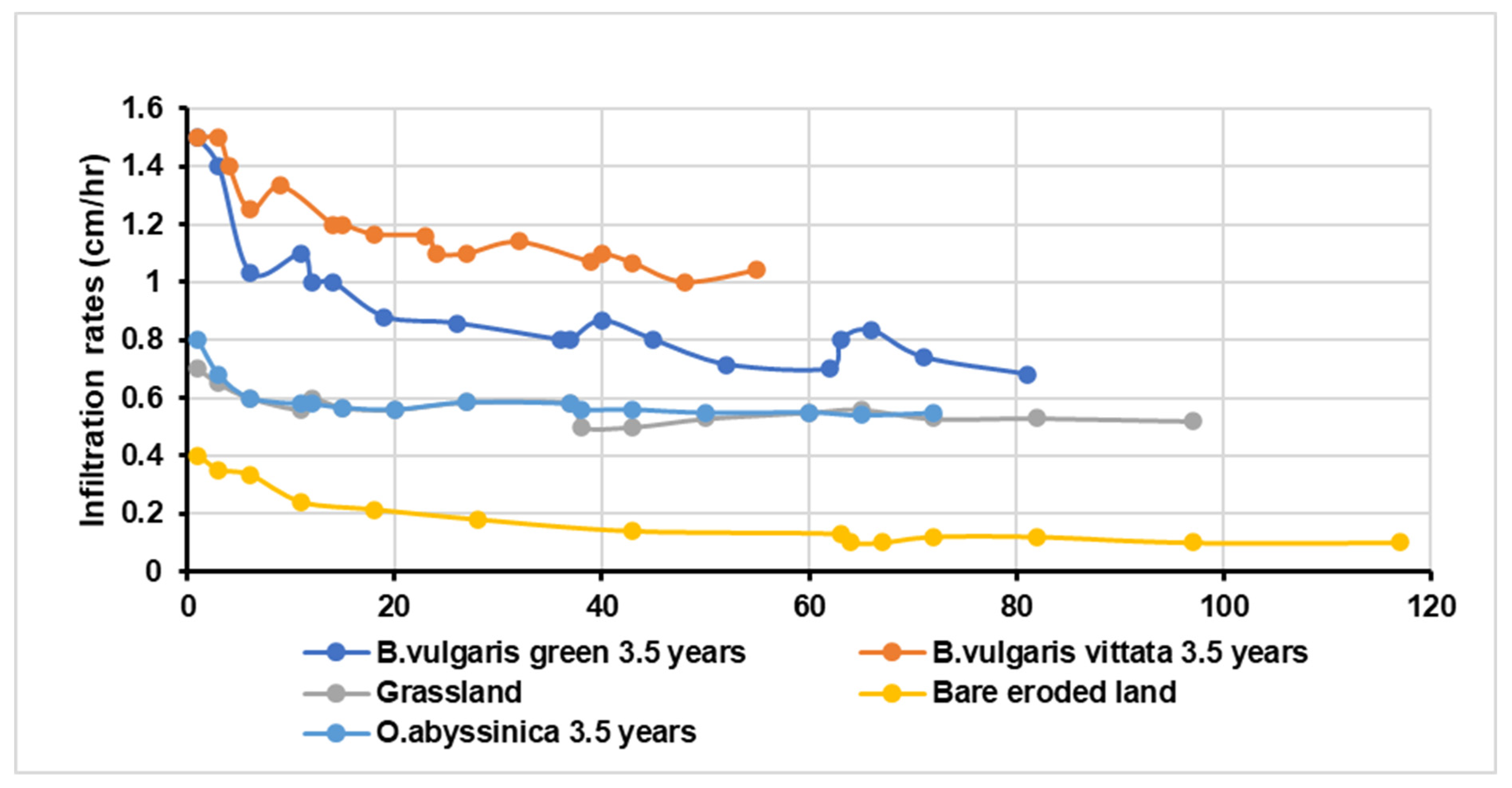
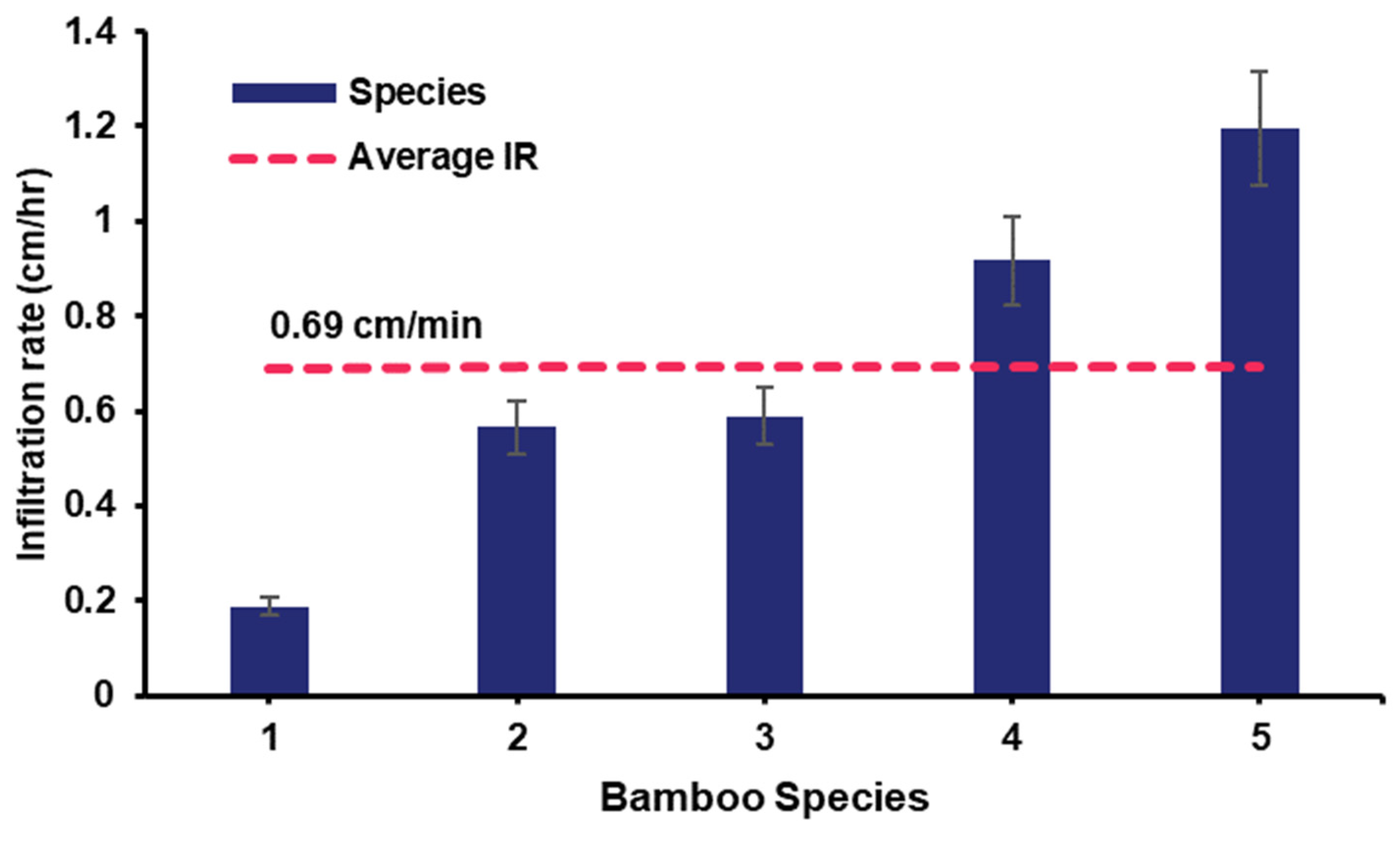
3.1. Water Infiltration in Bamboo and other Tree Plantation Soils
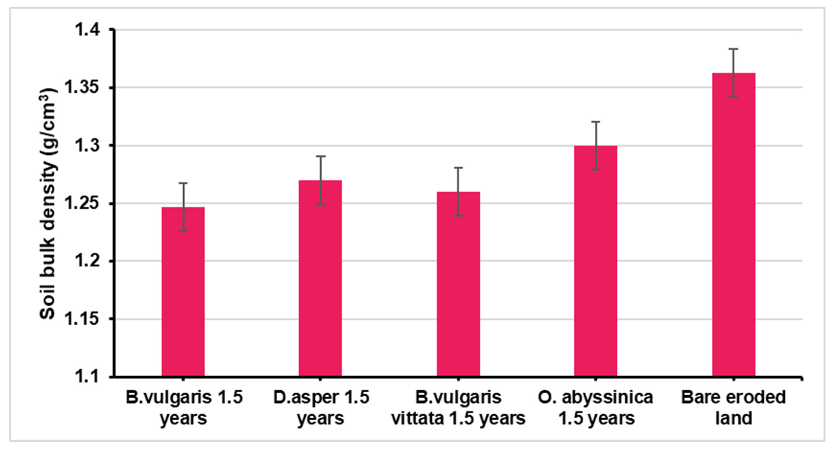
3.2. Soil Bulk Density of Bamboo Plantations
3.3. Runoff and Soil Loss in Bamboo Plantations
4. Discussion
5. Conclusions
Author Contributions
Funding
Data Availability Statement
Acknowledgments
Conflicts of Interest
References
- Viraj, G.; Sandeep, R.; Chaitanya, P. Correlation Analysis of Soil Nutrients and Prediction Model Through ISO Cluster Unsupervised Classification with Multispectral Data. Multimed. Tools Appl. 2022, 82, 2165–2184. [Google Scholar] [CrossRef]
- Kumar, P.; Narayan, M.; Bhushan, M. Rainfall intensity duration frequency curve statistical analysis and modeling for Patna, Bihar BOHR. Int. J. Civ. Eng. Environ. Sci. 2023, 2, 65–73. [Google Scholar]
- Kaushal, R.; Kumar, A.; Patra, S.; Islam, S.; Tomar, J.; Singh, D.; Mandal, D.; Kumar, R.; Mehta, H.; Chaturvedi, O.P.; et al. In-situ soil moisture conservation in bamboos for the rehabilitation of degraded lands in the Himalayan foothills. Ecol. Eng. 2021, 173, 106437. [Google Scholar] [CrossRef]
- Kaushal, R.; Kumar, A.; Jayaraman, D.; Mandal, D.; Rao, I.V.R.; Dogra, P.; Alam, N.M.; Gupta, A.; Tomar, J.M.S.; Singh, D.V.; et al. Research Methodologies for Field Monitoring, Analysis and Evaluation of Resource Conservation Aspects of Bamboos. INBAr 2018, 9, 124. [Google Scholar]
- Cheboiwo, J.; Langat, D.; Muga, M.; Kiprop, J. Economic Analysis of Forest Landscape Restoration Options in Kenya. KFS 2018, 1–68. [Google Scholar]
- UNCCD. Background Document, The Economics of Desertification, Land Degradation and Drought: Methodologies and Analysis for Decision-Making. In 2nd Scientific Conference on Economic Assessment of Desertification, Sustainable Land Management and Resilience of Arid and Dry Sub-Humid Areas; UNCCD: Bonn, Germany, 2013. [Google Scholar]
- Le, Q.B.; Nkonya, E.; Mirzabaev, A. Biomass productivity-based mapping of global and degradation hotspots. ZEF-Discuss. Pap. Dev. Policy 2014, 193, 55. [Google Scholar] [CrossRef]
- National Environment Management Authority, NEMA. Integrated National Land use Guidelines For Sustained Societal Attributes—Infrastructure, Environmental Resources And Public Safety; INTERMASS Printers and Stationers Ltd.: Nairobi, Kenya, 2011. [Google Scholar]
- UNEP. Mau Forest Complex. Environmental Change Hotspots. Division of Early Warning and Assessment (DEWA); United Nations Environment Programme (UNEP): Nairobi, Kenya, 2010; Available online: https://na.unep.net/atlas/webatlas.php?id=2236 (accessed on 23 May 2024).
- Kiage, L.M.; Liu, K.B.; Walker, N.D.; Lam, N.; Huh, O.K. Recent land-cover/use change associated with land degradation in the Lake Baringo catchment, Kenya, East Africa: Evidence from Landsat TM and ETM+. Int. J. Remote Sens. 2007, 28, 4285–4309. [Google Scholar] [CrossRef]
- Were, K.O.; Dick, Ø.B.; Singh, B.R. Remotely sensing the spatial and temporal land cover changes in Eastern Mau forest reserve and Lake Nakuru drainage basin, Kenya. Appl. Geogr. 2013, 41, 75–86. [Google Scholar] [CrossRef]
- Sinha, E.; Michalak, A.M.; Balaji, V. Eutrophication will increase during the 21st century as a result of precipitation changes. Science 2017, 357, 405–408. [Google Scholar] [CrossRef]
- Smith, V.H.; Joye, S.B.; Howarth, R.W. Eutrophication of freshwater and marine ecosystems. Limnol. Oceanogr. 2006, 51, 351–355. [Google Scholar] [CrossRef]
- Binzer, A.; Guill, C.; Rall, B.C.; Brose, U. Interactive effects of warming, eutrophication and size structure: Impacts on biodiversity and food-web structure. Glob. Chang. Biol. 2016, 22, 220–227. [Google Scholar] [CrossRef]
- Davis, J.M.; Rosemond, A.D.; Eggert, S.L.; Cross, W.F.; Wallace, J.B. Long-term nutrient enrichment decouples predator and prey production. Proc. Natl. Acad. Sci. USA 2010, 107, 121–126. [Google Scholar] [CrossRef]
- Dodds, W.; Smith, V. Nitrogen, phosphorus, and eutrophication in streams. Inland Waters 2016, 6, 155–164. [Google Scholar] [CrossRef]
- Government of Kenya. National Bamboo Policy, 2022; Ministry of Environment and Forestry: Nairobi, Kenya, 2022.
- Onozawa, Y.; Chiwa, M.; Otsuki, K. Rainfall interception in a Moso-bamboo (Phyllostachys pubescens) forest. J. For. Res. 2009, 14, 111–116. [Google Scholar] [CrossRef]
- Sujatha, M.G.; Lingaraju, B.S.; Palled, Y.B.; Ashalatha, K.V. Importance of integrated nutrient management practices in maize under rainfed condition. Karnataka J. Agric. Sci. 2008, 21, 334–338. [Google Scholar]
- Shinohara, Y.; Misumi, Y.; Kubota, T.; Nanko, K. Characteristics of soil erosion in a moso-bamboo forest of western Japan: Comparison with a broadleaved forest and a coniferous forest. Catena 2019, 172, 451–460. [Google Scholar] [CrossRef]
- Shinohara, Y.; Otsuki, K. Comparisons of soil-water content between a Moso bamboo (Phyllostachys pubescens) forest and an evergreen broadleaved forest in western Japan. Plant Species Biol. 2015, 30, 96–103. [Google Scholar] [CrossRef]
- USDA. Natural Resources Conservation Services. Soil Quality Indicators. 2008. Available online: https://www.nrcs.usda.gov/sites/default/files/2022-10/Infiltration.pdf (accessed on 31 May 2024).
- Ongugo, P.; Sigu, G.; Kariuki, J.; Luvanda, A.; Kigomo, B. Production to Consumption Systems. A Case Study of the Bamboo Sector in Kenya; KEFRI: Nairobi, Kenya, 2000. [Google Scholar]
- USS Working Group, WRB. World Reference Base for Soil Resources 2006. A Framework for International Classification, Correlation and Communication; World Soil Resources Report No 103; FAO: Rome, Italy, 2016. [Google Scholar]
- Kenya Soil Survey. Agro-Climatic Zones of Kenya Agro-Climatic Zones of Kenya; Kenya Agricultural Research Institute: Kakamega, Kenya, 2010. [Google Scholar]
- National Oceanic and Atmospheric Administration, NOAA. Global Climate Data. National Centers for Environmental Information. 2024. Available online: https://www.ncei.noaa.gov/ (accessed on 31 May 2024).
- Okalebo, R.; Gathua, K.W.; Woomer, P.L. Laboratory Methods of Soil and Plant Analysis: A Working Manual; TSBF/CIAT and SACRED Africa: Nairobi, Kenya, 2002. [Google Scholar]
- Trautmann, N.; Richards, T. Moisture Content. Cornell Composting, Science and Engineering; Cornell Waste Management Institute: Ithaca, NY, USA, 1996; Available online: https://compost.css.cornell.edu/calc/moisture_content.html (accessed on 31 May 2024).
- Smith, K.A.; Mullins, C.E. (Eds.) Soil Analysis: Physical Methods; Marcel Dekker: New York, NY, USA, 1991; pp. 329–366. [Google Scholar]
- Safari, N.; Kazemi, F.; Tehrani, A. Examining temperature and soil moisture contents of mulches in the urban landscaping of an arid region. J. Desert 2021, 26, 139–156. [Google Scholar] [CrossRef]
- Goel, L.; Shankar, V.; Sharma, R.K. Effect of organic mulches on agronomic parameters—A case study of tomato crop (Lycopersicon esculentum Mill.). Int. J. Recycl. Org. Waste Agric. 2020, 9, 297–307. [Google Scholar] [CrossRef]
- Sileshi, G.; Dagar, J.; Nath, A.; Kuntashula, E. Agroforestry as a climate-smart agriculture: Strategic interventions, current practices and policies. In Agroforestry for Sustainable Intensification of Agriculture in Asia and Africa; Springer Nature: Singapore, 2023; pp. 589–640. [Google Scholar] [CrossRef]
- Kaur, B.; Sur, K.; Verma, V.; Pateriya, B. Implications of Watershed Management Programs for Sustainable Development in Rural Scenario—A Case Study from Foothills of Punjab State, India. Water Conserv. Sci. Eng. 2022, 7, 1–9. [Google Scholar] [CrossRef]
- Nadir, W.S.; Ng’etich, K. W Effects of water soluble polyphenols in Eucalyptus grandis trees and their effects on crops and soil water repellency. Allelopath. J. 2018, 44, 79–92. [Google Scholar] [CrossRef]


| Plantation | Age (years) | Height (m) | Canopy Cover | Field Capacity (%) | Soil Texture | Soil pH |
|---|---|---|---|---|---|---|
| D. strictus | 30 | 13.5 | 13.4 | 25 | Sandy loam | 7.5 |
| B. bambos | 30 | 13.5 | 13.4 | 20 | Sandy loam | 7.7 |
| T. siamensis | 30 | 15 | 4.4 | 20 | Sandy loam | 7.7 |
| E. camaldulensis | 15 | 21.3 | 3 | 27 | Sandy loam | 7.8 |
| B. vulgaris | 1.5 | 4.5 | 4 | 28 | Sandy loam | 7.9 |
| G. arborea | 9 | 14 | 3.5 | 28 | Sandy loam | 7.5 |
| E. urophylla | 3.5 | 10.8 | 2.6 | 25 | Sandy loam | 7.8 |
| Indigenous forest | 30 | 13 | 4.2 | 20 | Sandy loam | 7.7 |
| Bare land/grass | - | - | - | 20 | Sandy loam | 7.7 |
| Plantation | Age (years) | Height (m) | Canopy Cover | Field Capacity (%) | Soil Texture | Soil pH |
|---|---|---|---|---|---|---|
| B. vulgaris | 3.5 | 13.5 | 7.3 | 35% | Loam | 7.8 |
| B. vulgaris vittata | 3.5 | 13.5 | 5.1 | 35% | Loam | 7.7 |
| O. abyssinica | 3.5 | 12 | 5 | 33% | Loam | 7.6 |
| Grassland | 0.5 | 0.4 | closed | 30% | Loam | 7.7 |
| Bareland/grass | 24% | Loam | 7.7 |
| Species | Infiltration Rate (cm/h) |
|---|---|
| Bare land/grass | 46.95 a |
| B. vulgaris 1.5 years | 53.38 a |
| B. vulgaris vittata 1.5 years | 54.14 a |
| O. abyssinica 1.5 years | 54.6 a |
| D. asper 1.5 years | 56.06 a |
| D. strictus 30 years | 62.31 a |
| E. camaldulensis 15 years | 66.96 a |
| G. arborea 9 years | 109.34 b |
| E. urophylla 3.5 years | 112.07 b |
| B. bambos 30 years | 126.45 b |
| Indigenous forest 30 years | 171.45 c |
| T. siamensis 30 years | 216.44 d |
| Mean | 94.200 |
| Bamboo Species | Infiltration Rate (cm/h) |
|---|---|
| Bare eroded land | 11.26 a |
| Grassland | 33.95 b |
| O. abyssinica 3.5 years | 35.35 b |
| B. vulgaris green 3.5 years | 55.01 c |
| B. vulgaris vittata 3.5 years | 71.75 c |
| Mean | 41.46 |
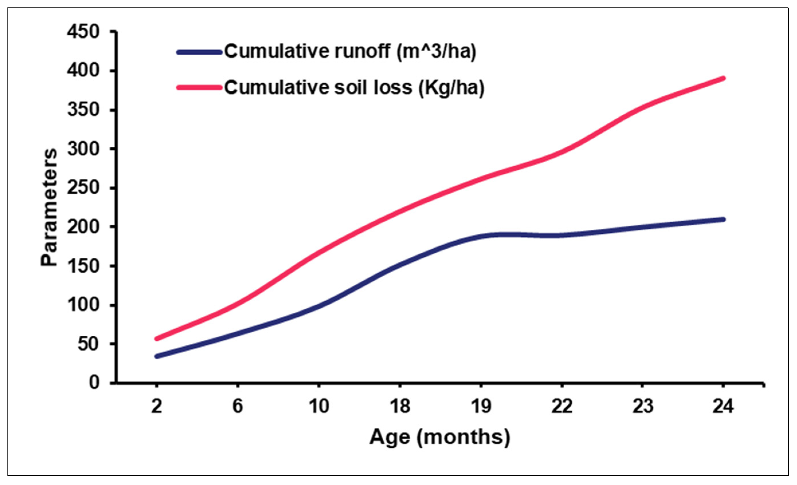
| Age of Bamboo (Months) | Cumulative Rainfall (mm) | Cumulative Runoff (m3/ha) | Cumulative Soil Loss (Kg/ha) |
|---|---|---|---|
| 2 | 33 | 34.8 | 57 |
| 6 | 89 | 63.9 | 101.7 |
| 10 | 158.5 | 98.7 | 166.8 |
| 18 | 294 | 151.5 | 219.6 |
| 19 | 373 | 187.95 | 261 |
| 22 | 380 | 189.45 | 295.5 |
| 23 | 413 | 199.95 | 352.5 |
| 24 | 443 | 209.85 | 390 |
Disclaimer/Publisher’s Note: The statements, opinions and data contained in all publications are solely those of the individual author(s) and contributor(s) and not of MDPI and/or the editor(s). MDPI and/or the editor(s) disclaim responsibility for any injury to people or property resulting from any ideas, methods, instructions or products referred to in the content. |
© 2024 by the authors. Licensee MDPI, Basel, Switzerland. This article is an open access article distributed under the terms and conditions of the Creative Commons Attribution (CC BY) license (https://creativecommons.org/licenses/by/4.0/).
Share and Cite
Nadir, S.; Kaushal, R.; Kumar, A.; Durai, J.; Reza, S.; Ndufa, J.; Ronoh, E.; Elema, M.; Thiga, J.; Kumar, M. Hydrological Response of Bamboo Plantations on Soil–Water Dynamics in Humid and Semi-Arid Coastal Region of Kenya. Water 2024, 16, 1894. https://doi.org/10.3390/w16131894
Nadir S, Kaushal R, Kumar A, Durai J, Reza S, Ndufa J, Ronoh E, Elema M, Thiga J, Kumar M. Hydrological Response of Bamboo Plantations on Soil–Water Dynamics in Humid and Semi-Arid Coastal Region of Kenya. Water. 2024; 16(13):1894. https://doi.org/10.3390/w16131894
Chicago/Turabian StyleNadir, Stanley, Rajesh Kaushal, Ambrish Kumar, Jayaraman Durai, Selim Reza, James Ndufa, Ernest Ronoh, Mohammed Elema, John Thiga, and Manish Kumar. 2024. "Hydrological Response of Bamboo Plantations on Soil–Water Dynamics in Humid and Semi-Arid Coastal Region of Kenya" Water 16, no. 13: 1894. https://doi.org/10.3390/w16131894