Case Report

Groundwater Sustainability Planning in California: Recommendations for Strengthening the Kern Groundwater Sustainability Plan

1
Sustainability Program, San Diego State University, San Diego, CA 92182, USA
2
Department of Geography, San Diego State University, San Diego, CA 92182, USA
*
Author to whom correspondence should be addressed.
Water 2024, 16(17), 2442; https://doi.org/10.3390/w16172442 (registering DOI)
Submission received: 27 June 2024 / Revised: 14 August 2024 / Accepted: 21 August 2024 / Published: 29 August 2024
(This article belongs to the Special Issue Studies on Water Resource and Environmental Policies)

Abstract

:
Kern County is one of the most valuable agricultural counties in the nation. This, however, is being put in jeopardy with the recently implemented Sustainable Groundwater Management Act (SGMA) in response to the ongoing California drought and extensive groundwater pumping for irrigation. The Groundwater Sustainability Agencies (GSAs) are responsible for developing Groundwater Sustainability Plans to address the new SGMA policies. The objective of this paper is to examine the Kern Groundwater Sustainability Plan (KGSP), determine its strengths and weaknesses, and provide recommendations for the updated plan released in 2025. The plan performs well in defining criteria that must be met, but fails to address how these goals will be implemented. Based on our policy analysis, our recommendations include standardizing groundwater management terms across sub-basins, defining clear measurements of undesirable results, utilizing financial (dis)incentives to encourage groundwater users to manage water sustainably, and increasing interconnections between local and state organizations. Importantly, improving this policy process for the SGMA may be an example for critically overdrafted groundwater basins globally on how to more sustainably manage their groundwater.

1. Introduction

Groundwater is a critical water resource globally, supporting people’s drinking water supply, agricultural production, and ecosystems [1,2,3]. However, recent studies of groundwater levels have found significant overdraft globally [4], and groundwater declines have been accelerating in 30% of the world’s aquifers over the last few decades [5]. Therefore, developing policy mechanisms to curb the decline in groundwater resources, or even replenish aquifers, is critical to sustaining groundwater levels and sustaining agricultural and municipal water supply.
Despite producing over USD 50 billion in agricultural products per year, California, USA, often suffers from a growing scarcity in surface and groundwater resources for irrigated agriculture and domestic uses [6,7,8]. Drought is nothing new to the agricultural sector in California. However, recent drought has emphasized the region’s vulnerability to water scarcity, leading to a large gap between productive agricultural land and available water [9]. While surface water has been highly regulated in California for over a century, groundwater has no formal management or policy regulations. In order to mitigate this, California began implementing groundwater regulations aimed at sustainable resource use through the Sustainable Groundwater Management Act (SGMA).
In this paper, we utilize the SGMA and Kern County California as a case study in order to better understand how to create effective policies and plans to regulate groundwater resources. In this paper, we will assess the strengths and weaknesses of the revised Kern Groundwater Sustainability Plan (KGSP), and how the changes to the plan from the original help to meet the criteria of the SGMA. We focus this paper on Kern County, which spans the southern end of the Central Valley, in Bakersfield, California. Kern County groundwater basins have had the greatest decrease in groundwater resources in California, draining below sustainable levels [10]. While the SGMA is meant to help manage and maintain water reserves for the future, in many places, especially Kern County, this will lead to a reduction in groundwater available to agriculture. This is cause for concern as Kern County is the second-largest agricultural county in the country, providing food for the nation [7]. Many local public facilities and communities also rely on groundwater for economic stability and household consumption.
A key component of the SGMA, Groundwater Sustainability Agencies (GSAs) are being tasked with creating Groundwater Sustainability Plans (GSPs). With 503 of the 1200 public supply wells in the region expected to be partially or completely dry at the established minimum thresholds [11], it is important that we analyze the newest GSP as of July 2022, in terms of its effectiveness and smoothness as it transitions Kern County to a more sustainable groundwater consumption level. These GSPs and their implementation can provide a gateway to sustainably managing groundwater resources for all agricultural areas suffering from drought. Previously, the KGSP had deficiencies which did not enable it to meet the criteria entailed by the SGMA. More specifically, “the Plan does not set minimum thresholds for chronic lowering of groundwater levels in a manner consistent with the requirements of SGMA and the GSP regulations” [12] (p. 2). In this paper, we provide recommendations for how the current KGSP can be improved and administered to meet these requirements. The continual development of GSAs throughout the state, and its implementation of GSPs, can serve as the foundation for other regions in the world to more sustainably manage their groundwater resources.

SGMA Requirements

SGMA is a three-bill package that sets the framework that allows local governments to allocate management and planning in the hands of GSAs in order to achieve the sustainability goals for each basin over a 20-year period [13]. Figure 1 shows the contours for groundwater levels that determine the regional minimum threshold and measurable objectives for future groundwater levels, which will be elaborated upon later.
In order to measure, numerically quantify, and define undesirable results and sustainable goals—a specific requirement by the SGMA—the KGA has developed minimum thresholds and measurable objectives within each management area (see Figure 1). Second, each management area has a water budget that will together eliminate the KGA Member Agencies deficit of 239,346 acre-feet per year by 2040. Finally, the KGA has implemented projects and management actions that will be identified later in the paper [12] (p. 197).
The KGSP goals work above the requirements of the SGMA with the intention to catch problems before they proliferate, as we see in the Arvin-Edison management area [14] (p. 167). The KGSP also sets the goal of achieving sustainable groundwater management through projects and management actions at the GSA level. Considering the vast differences in hydrology and geography, it is necessary to have proper management at a more micro level. Lastly, the KGSP intends to protect beneficial users for water supply wells [15] (pp. 12, 19). Examples of beneficial uses include supplying residential, municipal and industrial needs, irrigation, recreation, hydroelectric power, and the protection and enhancement of fish and wildlife [16].
The GSP monitoring network is being supplemented with local data on groundwater elevation to establish groundwater elevation contour maps for the principal aquifers in the sub-basin, made public on the kerngwa website (see Figure 1). This will include wells that are being recorded by the Kern Fan Monitoring Committee and other water data available [17] (p. 12). The aquifers in Kern County have different zones of confined, semi-confined, and unconfined groundwater states. These various conditions lead to some areas, such as the western side of the sub-basin, having very limited and little usable groundwater, while other areas like the east have alluvium and the Kern River Formation, which provide good water quality [12] (pp. 82–83).

2. Kern Groundwater Sustainability Plan Deficiencies and Recommendations

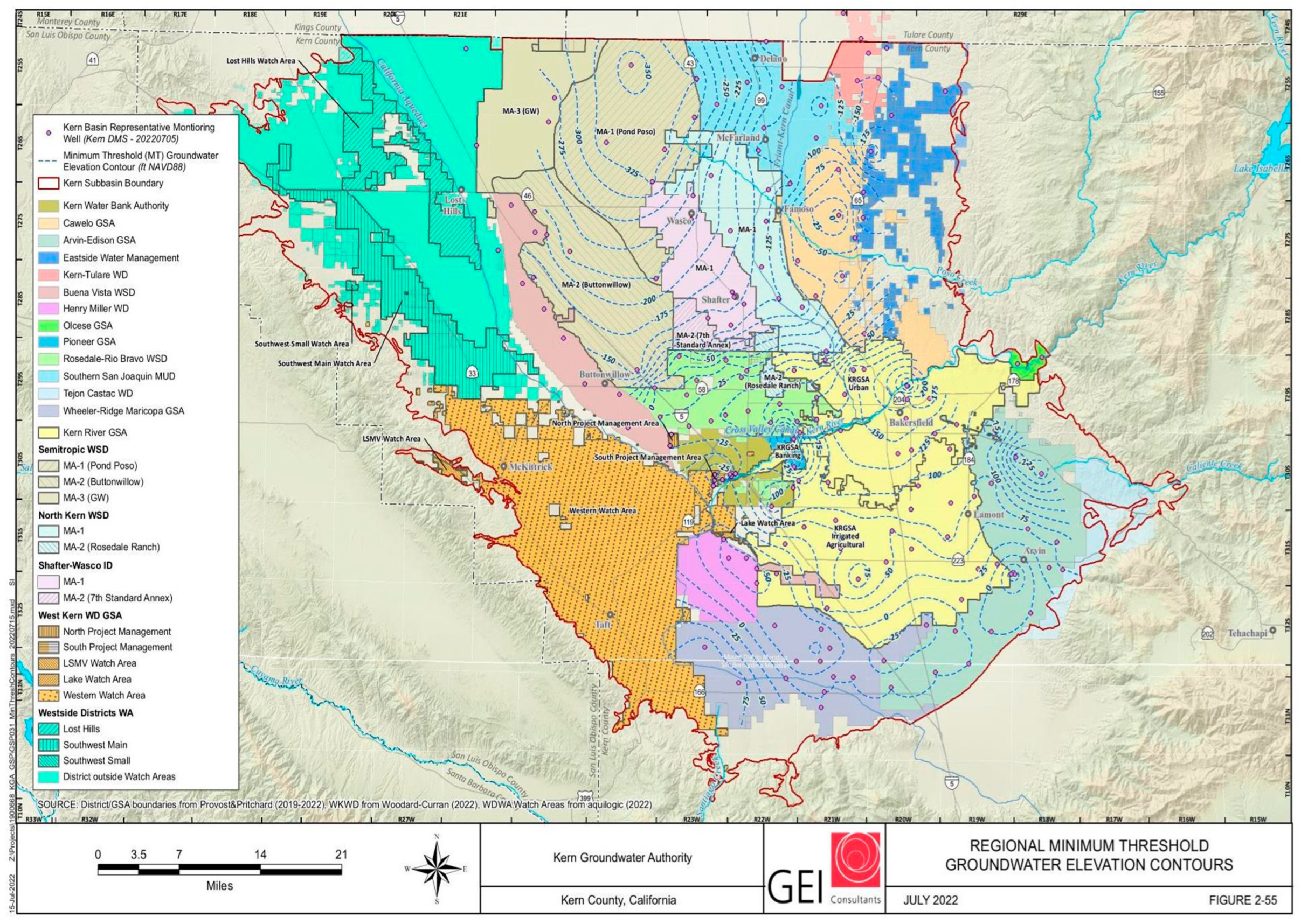
2.1. Inconsistencies across Sub-Basins

The first deficiency in the original KGSP is that the plan does not remain consistent throughout the entire sub-basin. The unclear terminology makes it difficult to compare the different plans of the GSA, and does not comprehensively report on the status of minimum threshold exceedances by area [18] (p. 33). The following sections describe the major terminology that is officially defined, as well as the minimum thresholds.
First, the original plan used the term ‘undesirable results’ and defines it as “the geographic extent of minimum threshold exceedances across the entire sub-basin, measured by the accumulation of management area exceedance” [12] (p. 198). The geographic undesirable results are determined to be subsidence, the lowering of groundwater levels, and a reduction in water quality. The original KGSP lacked an explanation of the specific effects, such as lowering groundwater levels, developing throughout the sub-basin that are considered undesirable results [19]. It was recommended that the revised plan goes into detail on how these undesirable results remain consistent with both the SGMA and the GSP regulations.
To address this issue, in the revised KGSP, the definition of an undesirable result is redefined as 40% exceedance of a managed area over minimum thresholds for over four consecutive bi-annual SGMA monitoring events [12] (p. 3). Figure 2 gives a representation of the Minimum Threshold Exceedance Management policy and the establishment of an undesirable result.
Minimum thresholds are an SGMA requirement consisting of numerical values calculated by a monitoring network at each sustainability indicator, where evaluations determine the level at which groundwater conditions will lead to an undesirable result [18] (p. ES-4). These thresholds ensure the consideration of the diverse distribution of beneficial users as it avoids significant and unmitigable impacts on them [12] (p. 3). In order to effectively identify potential minimum threshold exceedances before water levels fall below the SGMA requirements, the Sustainable Management Criteria (SMC) have been set to be more thorough than the SGMA’s required minimum thresholds. The revised KGSP provides information detailing exactly how many wells must exceed the minimum threshold in each area in order trigger an undesirable result.
These changes will improve the overall sustainability of the basin as they allow for a set number to be determined throughout the basin. However, the percentage fails to provide a transition plan for beneficial users. It is clear that no matter how detailed and selective the plan becomes, there will have to be a reduction in water use. Finding specific areas struggling with declining groundwater levels can greatly progress the future sustainability of Kern County. So long as they are strategic, these changes can provide the vital opportunity to balance a vibrant agricultural economy and the maintenance of natural ecosystems, providing an abundance of public benefits [20].
That being said, the plan does not include any details on how it will encourage farmers to adhere to the KGSP. The KGSP’s only action proposals are to increase their understanding of the impacts of lowering groundwater levels, such as subsidence. While this is important, simply obtaining the information will not lead to change. In our previous research, where key stakeholders in Kern County were interviewed, it was brought up numerous times that many farmers had no intention of changing their water or land usage until proper enforcement was put into place [3]. Indeed, Kern County ranked third for the most installations of new irrigation wells in the past five years (WY 2019 through WY 2023) [10]. Additionally, the total land-use footprint for both active and fallow agricultural rangeland and parcels in Kern County stayed relatively stable between the years 2002 and 2018 [21]. In order to adjust to drought while maintaining profitability, they expanded perennial crops, such as almonds and pistachios. With continuing financial benefits towards agriculture, and without incentives to reduce water use, it will be difficult to modify the scale of current agricultural production in Kern County. Thus, it is important to manage crop composition shifts based on known risk factors in order to allow farmers and policymakers to obtain an edge in optimizing the utilization of agricultural landscapes for the future [21].
Under the SGMA, groundwater sustainability should be reached by 2040. This incentivizes farmers to increase their water usage in the meantime, obtaining as much profit from their lands before any real enforcement is pursued. The great distrust of the public towards the government makes clear that there will be little support from the beneficial users in adhering to the goals set by the KGSP. It is important to have a very specific plan for what will be done with retired lands, and how the KGA plans to enforce their sustainable goals, so that the transition can be carried out as smoothly and effectively as possible. Allowing farmers to better understand the situation will help them become more compliant with the changes. Despite their actions, in our previous work, interviewees understood that their current water usage was unsustainable, and it was more so that the transition plans were too broad and unclear, leading to disagreements [3]. Thus, including the KGSP, each of the GSA’s specific plans on how to transition the land that is to be retired, as well as researching what general areas will have to be put out of work, is essential.
This also leads to concerns regarding social justice issues, as larger corporations can afford increased fees to continue higher water usage, while smaller local communities will be pushed out. In one previous interview with a Kern County stakeholder, it was noted that the SGMA gives people the opportunity to consolidate water into fewer hands and to privatize it, building a water market favoring those who can bid the highest for water [3]. This becomes a greater issue when we see that sixty-eight percent of the 505 smaller water systems supporting smaller communities, who cannot afford higher water prices, rely on groundwater as their main or only water source [22] (p. 19). When it is multi-million dollar corporations against smaller generational farming communities, smaller farmers are forced to retire [3]. It is important that the KGSP takes this into consideration when it comes to meeting the water management requirements and how they intend to enforce it. A possible solution to this could be rather to look at the most advantageous places to retire land (in terms of soil quality, geography, etc.), and put more resources into buying off that land to retire it. This way, the retired land is more neutral and beneficial to the people. Another solution could be to focus on purchasing land that has not yet been used for agriculture in Kern County and conserve what is left of the natural environment [3]. This is especially important considering how restored agricultural land will never completely replicate the natural geographical aspects of untouched land.

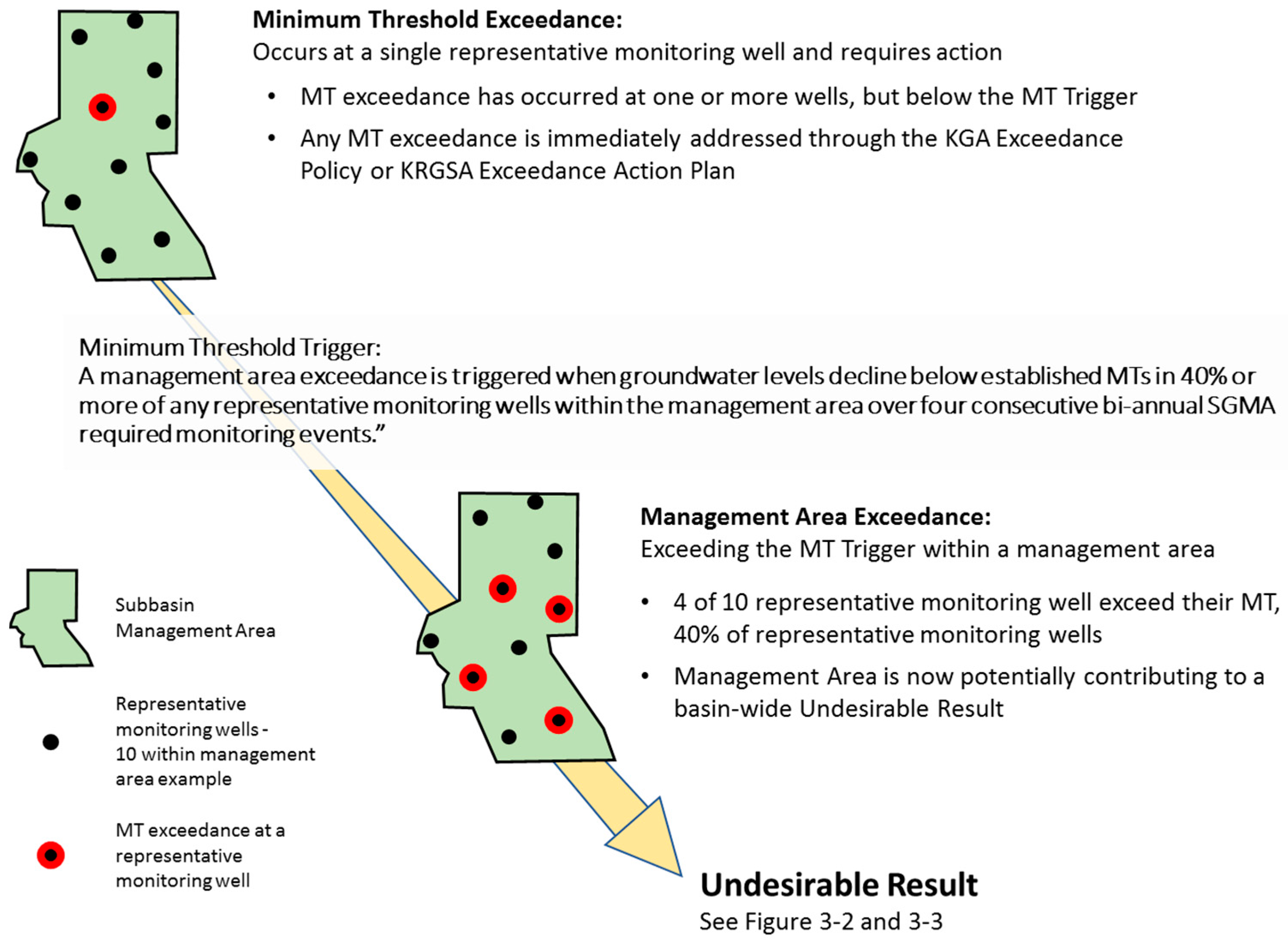
2.2. Inadequate Data

The California Department of Water Resources (DWR) staff’s review of the original KGSP indicated a lack of analysis and data to support the management plan. For this revised plan, the DWR suggests that the KGSP explore the impacts of all beneficial users and uses, and address what is being avoided by these determined actions, such as how drought and the dewatering of wells have a greater impact on the smaller public water systems supporting marginalized communities [12,15,23]. The majority of KGA members have a greater number of agricultural users than municipal and domestic users, so it is important that they strike a balance between impacting municipal and domestic wells and agricultural beneficial users [12] (p. 13). The revised KGSP goes over its water well depth analysis as a justification for the SMC, as well as providing any impacts that may occur as a result of it.
To address this second major deficiency, the KGA management areas used a Well Impact Study in order to identify the types of beneficial users within each management area who rely on groundwater resources. The study, referenced in Table 1 and Table 2, reflects the impact on each beneficial user operating at the measurable objective, as well as what exceeding the minimum threshold will look like in terms of dewatered wells. In order to avoid reaching the minimum thresholds, the KGA establishes the Action Plan Related to Exceedance of Minimum Thresholds for Chronic Lowering of Groundwater. This is a proactive approach to identifying and working with a single, isolated exceedance [12] (pp. 27, 29).
It is important to note that the geographies of the areas in Kern County are so different that they require different standards of sustainability and groundwater usage. The variation in land use and water sources from the west side of the basin differs from that on the east side, as well as from the north boundary line to the south. For example, the west side of the Kern sub-basin finalized a preliminary assessment of native soils, with further plans to continue studies as a component of the subsidence assessment, for the 2025 SGMA update. The eastern alluvial fans have igneous- and metamorphic-origin soils. This means that the soils have efficient drainage and low salinity levels, making them the ideal candidate for agriculture, unlike those of the northwestern region consisting of poor drainage soils of relatively lower quality [12] (pp. 37, 104–105). Thus, each area will have a different response to groundwater activities, and they should all be separately monitored and treated as such. These differences are illustrated in Figure 3 and Figure 4, where the land use and land water sources for the Kern sub-basin are displayed. Management actions in sub-basin GSPs address the various geologic and physical properties of the land to determine the best implementation of the GSPs [18] (p. 33). The revised KGSP adjusts the monitoring network to be capable of demonstrating the seasonal, short-term (1 to 5 years), and long-term (5 to 10 years) trends for groundwater and its respective surface conditions, providing representative information about groundwater conditions, which is crucial in the assessment of plan implementation [12] (p. 244).
There are strengths and weaknesses to the GSP revisions. Using wells is a good indicator of water quality, groundwater availability, and, in some cases, subsidence. With this information, the KGSP can project future water budgets based on SGMA implementations, and prepare beneficial users for what their future water use will look like. The KGSP goes into much detail on the effects that such undesirable results will have on beneficial users. This enables a higher incentive to maintain the measurable objectives set for each management area. Indeed, in the Kern County 2022 Third Annual Report on their 2021 water year, it was noted that the increased awareness of sustainability was likely to have played a part in growers’ limited groundwater usage during extended drought periods [17]. The new plan also provides a table, listing specific deficiencies within the original KGSP, the suggested corrective action, the proposed response, and coordination with neighboring districts. It is important to note the fluidity of groundwater resources, and how the state of one management area can very well affect its neighboring areas.
While the KGA’s well impact study appropriately satisfies the second deficiency in the original KGSP, further research must be conducted on the social justice issues that these regulations will have on small farming communities. It was stated that the GSP should give a voice to all beneficial users, but the KGSP fails to ever specify the impacts on specific communities within agricultural users. In our previous work, it was often remarked how the first producers to go out of production were small farmers [3]. Without the support of the government, it will simply become more cost effective for local and smaller farmers to give up their generation-long work of farming and sell it for solar use [3]. Thus, we suggest putting more funding into aiding smaller agricultural communities, including farmworkers, in this transition to more sustainable water usage, for example, providing re-education for people to work on solar farms or other jobs that will be taking over their areas. While putting some smaller agricultural workers out of work may be unavoidable, it is still important to help give opportunities to small farm workers so that poverty and unemployment rates do not increase.

2.3. Subsidence Needs a Better Understanding

The DWR has recently deemed subsidence to be a deficiency that can lead to undesirable results [19]. Subsidence, however, remains very under-researched, and there are little data that can help us to efficiently reduce subsidence to a sustainable level. Thus, while subsidence is a deficiency that needs to be addressed in the GSPs, all of the plans have delayed setting significant and sustainable management requirements until additional data have been obtained; therefore, the current SMC will remain valid only until 2025, when the updated GSP comes out [12] (p. 239).
All areas of interest in terms of land subsidence have vastly different geographical features that appear to play a role in the causes of subsidence. While land subsidence is not new, it has greatly advanced during the recent drought years, making it crucial to monitor [15] (p. 26). To this end, the KSC is inputting a number of extensometers in the sub-basin, and the DWR-CASP and FWA are cooperating in planning installations of other geodetic-based monitoring technology through the sub-basin to conduct more intensive research [12].
Finding even a temporary plan for subsidence could possibly save the Kern sub-basin a fortune in repair costs. From 1955 to 1972, the California Aqueduct, and other regional and local water-delivery and flood-control structures, have been documented to have costs related to subsidence of over USD 1.3 billion [24]. Although pumping regulations are being implemented, it may be discovered that more strict measures are necessary to avoid subsidence. It is imperative that this knowledge be provided to local and beneficial groundwater users so that cooperation with the GSAs happens smoothly and effectively.

3. Recommendations

The revised KGSP has implemented many changes to the KGP that allow for more fluid and cohesive management strategies throughout the sub-basin to be implemented. Clarification and basin-wide definitions of important terms are set, sanctioning plans that adhere to the SGMA regulations. An explanation of impacts resulting from undesirable results specifies why sustainable management actions must be taken, even when complete analysis data on things like subsidence remain insubstantial. However, the GSPs submitted to the DWR in January 2020 and amended in July 2022 were deemed inadequate [25]. There is still a lack of information on the impact the measurable objectives have on beneficial users. There are also minimal proposals on how the KGA intends to obtain the support of beneficial users towards implementing these plans. Overall, however, the KGSP sets the basic groundwork for the updated version that is to be released in 2025.
Understanding the lessons learned in planning for sustainable groundwater management can have implications for other areas of California and beyond. Clear and measurable goals are critical, as are financial (dis)incentives for farmers and groundwater users to manage water sustainably. This iterative process between the KGSA and the DWR is an innovative way to create policy from the ground-up while meeting the overarching policy objectives of the state. This type of model might prove useful elsewhere, as do the recommendations put forward in this paper. As many regions of the world face groundwater depletion, finding ways to mitigate this is critical to a sustainable future. Policy solutions such as the SGMA may be one way to help maintain or improve groundwater levels, which support much of the world’s drinking water supply, irrigated agriculture, and ecosystems [1,2,4].

Author Contributions

Conceptualization, K.O.; writing—original draft preparation, K.O. and A.Q.; writing—review and editing, K.O. and A.Q.; visualization, K.O.; supervision, A.Q.; project administration, A.Q.; funding acquisition, A.Q. All authors have read and agreed to the published version of the manuscript.

Funding

We acknowledge funding from the US Department of Agriculture—National Institute of Food and Agriculture—Sustainable Agroecosystems Program (grant number 2022-67019-36397) and the San Diego State University Summer Undergraduate Research Program that supported Okamura.

Data Availability Statement

Data are contained within the article.

Acknowledgments

We acknowledge Ashley E. Larsen, Gracie Bartel, and Daniel Sousa of San Diego State University who were a part of the San Diego State University Summer Undergraduate Research Program and aided in providing some of the data and inspiration for this paper.

Conflicts of Interest

The authors declare no conflict of interest.

References

  1. Dillon, P.; Fernández Escalante, E.; Megdal, S.B.; Massmann, G. Managed Aquifer Recharge for Water Resilience. Water 2020, 12, 1846. [Google Scholar] [CrossRef]
  2. Marwaha, N.; Kourakos, G.; Levintal, E.; Dahlke, H.E. Identifying Agricultural Managed Aquifer Recharge Locations to Benefit Drinking Water Supply in Rural Communities. Water Resour. Res. 2021, 57, e2020WR028811. [Google Scholar] [CrossRef]
  3. Quandt, A.; Larsen, A.E.; Bartel, G.; Okamura, K.; Sousa, D. Sustainable groundwater management and its implications for agricultural land repurposing. Reg. Environ. Chang. 2023, 23, 120. [Google Scholar] [CrossRef]
  4. Rohde, M.M.; Froend, R.; Howard, J. A global synthesis of managing groundwater dependent ecosystems under sustainable groundwater policy. Groundwater 2017, 55, 293–301. [Google Scholar] [CrossRef] [PubMed]
  5. Jasechko, S.; Seybold, H.; Perrone, D.; Fan, Y.; Shamsudduha, M.; Taylor, R.G.; Fallatah, O.; Kirchner, J.W. Rapid groundwater decline and some cases of recovery in aquifers globally. Nature 2024, 625, 715–721. [Google Scholar] [CrossRef] [PubMed]
  6. Greene, C. “Drought isn’t just water, it is living”: Narratives of drought vulnerability in California’s San Joaquin Valley. Geoforum 2021, 121, 33–43. [Google Scholar] [CrossRef]
  7. Olivier, C. As Kern County Goes, So Goes the Nation; Capitol Weekly: Sacramento, CA, USA, 3 May 2022. [Google Scholar]
  8. Sugg, Z. An Equity Autopsy: Exploring the Role of Water Rights in Water Allocations and Impacts for the Central Valley Project during the 2012–2016 California Drought. Resources 2018, 7, 12. [Google Scholar] [CrossRef]
  9. Hanak, E.; Lund, J.; Arnold, B. Water Stress and a Changing San Joaquin Valley; Public Policy Institution of California: San Francisco, CA, USA, 2017. [Google Scholar]
  10. California Department of Water Resources. California’s Groundwater Conditions: Semi-Annual Update, October 2023, Fall Bulletin 118 Information Update. October 2023. Available online: https://cawaterlibrary.net/document/californias-groundwater-conditions-semi-annual-update-october-2023/ (accessed on 10 February 2023).
  11. Bostic, D. At Risk: Public Supply Well Vulnerability Under California’s Sustainable Groundwater Management Act; Pacific Institute: Oakland, CA, USA, 2021; Available online: https://pacinst.org/publication/at_risk_wells_sgma/ (accessed on 22 March 2023).
  12. Gosselin, P. Groundwater Sustainability Plan; Department of Water Resources: Kern County, CA, USA, 2022; Available online: https://kerngwa.com/wp-content/uploads/2022/07/kga-amended-gsp-submitted-july-2022.pdf (accessed on 10 February 2023).
  13. California Department of Water Resources. Major Milestone to Achieving Sustainable Groundwater Management; California Department of Water Resources: Sacramento, CA, USA, 13 January 2022.
  14. Eki Environment and Water. Management Area Plan. Arvin-Edison Management Area, Kern County Subbasin. December 2019. Available online: https://kerngwa.com/wp-content/uploads/2022/07/arvin-edison-water-storage-district-management-area-plan.pdf (accessed on 10 February 2023).
  15. Mknelly, B. The Sustainable Groundwater Management Act (SGMA): Long Overdue, But Is It Living Up to Its Potential? Bachelor’s Thesis, Scripps College, Claremont, CA, USA, 2021. Available online: https://scholarship.claremont.edu/scripps_theses/1697 (accessed on 10 February 2023).
  16. Water Rights in California; Water Education Foundation: Sacramento, CA, USA, 22 June 2020; Available online: https://www.watereducation.org/aquapedia/water-rights-california (accessed on 10 February 2023).
  17. Kern County Subbasin Groundwater Sustainability Agencies. Kern County Subbasin Basin No. 5-022.14. Groundwater Sustainability Plans: (GSPs) Third Annual Report Water Year 2021. Todd Groundwater. 2022. Available online: https://kerngwa.com/wp-content/uploads/2022/07/2022-annual-report-final-3-30-2022.pdf (accessed on 10 February 2023).
  18. Todd Groundwater. Cawelo GSA REVISED Groundwater Sustainability Plan. 14 July 2022. Available online: https://kerngwa.com/wp-content/uploads/2022/07/revised-final-cawelo_gsp_jul14_2022-complete-clean.pdf (accessed on 10 February 2023).
  19. Maven. Groundwater Rights Primer: What Agencies & Project Developers Need To Know. MAVEN’S NOTEBOOK|Water News. 7 March 2018. Available online: https://mavensnotebook.com/2018/03/07/groundwater-rights-primer-agencies-project-developers-need-know/ (accessed on 10 February 2023).
  20. Kelsey, R.; Hart, A.; Butterfield, H.S.; Dink, V. Groundwater sustainability in the San Joaquin Valley: Multiple benefits if agricultural lands are retired and restored strategically. Calif. Agric. 2018, 72, 150–154. [Google Scholar] [CrossRef]
  21. Wartenberg, A.C.; Moanga, D.; Potts, M.D.; Butsic, V. Limited Economic-Ecological Trade-Offs in a Shifting Agricultural Landscape: A Case Study From Kern County, California. Front. Sustain. Food Syst. 2021, 5, 650727. [Google Scholar] [CrossRef]
  22. California State Water Resources Control Board. Human Right to Water Portal. Available online: https://www.waterboards.ca.gov/water_issues/programs/hr2w/ (accessed on 10 February 2023).
  23. Feinstein, L.; Phurisamban, R.; Ford, A.; Tyler, C.; Crawford, A. Drought and Equity in California; Pacific Institute: Oakland, CA, USA, 2017. [Google Scholar]
  24. Faunt, C.C.; Sneed, M.; Traum, J.; Brandt, J.T. Water availability and land subsidence in the Central Valley, California, USA. Hydrogeol. J. 2016, 24, 675–684. [Google Scholar] [CrossRef]
  25. Todd Groundwater. Kern County Subbasin Groundwater Sustainability Plans. 31 March 2023. Available online: https://kerngwa.com/wp-content/uploads/2023/04/Kern-BASIN-5-022.14-WY2022-AnnReport-03-31-2023.pdf (accessed on 10 February 2023).
Figure 1. Regional minimum threshold contours for groundwater levels [12]. - - - represents the minimum threshold groundwater elevation contour.
Water 16 02442 g001
Figure 2. Representation of KGA Minimum Threshold Exceedance Management policy [12].
Water 16 02442 g002
Figure 3. Land use within Kern County sub-basin [12]. Key: dark green—Deciduous fruits and nuts. Orange—citrus and subtropical. Purple—vineyards. Dark gray—urban. Neutral—native vegetation.
Water 16 02442 g003
Figure 4. Agricultural land water sources within Kern County sub-basin [12]. Green: groundwater only. Yellow: mixed groundwater/surface water.
Water 16 02442 g004
Table 1. Tabular summary of wells potentially dewatered at the measurable objective [12].
Number of Wells Number of Dewatered Wells
M D A % M/D
Wells
M D A % M/D
Wells
CWD 0 93 197 32% 0 0 0 0%
EWMA 2 11 41 24% 0 0 0 0%
NK 1 22 161 13% 0 0 2 0%
KTWD 0 18 94 16% 0 0 0 0%
RRB 24 149 156 53% 0 0 0 0%
SWID 16 68 118 42% 0 8 7 10%
SSJMUD 19 67 243 26% 0 13 11 15%
SWSD 4 138 763 16% 0 10 4 7%
WDWA 0 2 35 5% 0 0 0 0%
WKWD 13 0 0 100% 0 0 0 0%
7th Standard 2 9 19 37% 0 2 0 18%
Total81577182726%033245%
Notes: 0 Municipal wells going dry at the MT. Anyone over 5% of Domestic wells dewatered required to put together a mitigation plan. M = municipal; D = domestic; and A = agricultural.
Table 2. Tabular summary of wells potentially dewatered at the minimum threshold [12].
Number of Wells Number of Dewatered Wells
M D A % M/D
Wells
M D A % M/D
Wells
CWD 0 93 197 32% 0 3 1 3%
EWMA 2 11 41 24% 0 3 0 23%
NK 1 22 161 13% 0 2 5 9%
KTWD 0 18 94 16% 0 0 0 0%
RRB 24 149 156 53% 0 21 0 12%
SWID 16 68 118 42% 0 22 13 26%
SSJMUD 19 67 243 26% 0 29 25 34%
SWSD 4 138 763 16% 0 41 52 29%
WDWA 0 2 35 5% 0 0 0 0%
WKWD 13 0 0 100% 0 0 0 0%
7th Standard 2 9 19 37% 0 5 2 45%
Total81577182726%01269819%
Notes: 0 Municipal wells going dry at the MT. Anyone over 5% of Domestic wells dewatered required to put together a mitigation plan. M = Municipal, D = Domestic, and A = Agricultural.
Disclaimer/Publisher’s Note: The statements, opinions and data contained in all publications are solely those of the individual author(s) and contributor(s) and not of MDPI and/or the editor(s). MDPI and/or the editor(s) disclaim responsibility for any injury to people or property resulting from any ideas, methods, instructions or products referred to in the content.

