
Approach and Permanent Human Occupation of Mainland Portugal Coastal Zone (1096–2021)
by
 , , , and
Maria Rosário Bastos
1,2,*,
Olegário Nelson Azevedo Pereira
3,
Antero Ferreira
2,4,
Filipe Salgado
2,4,
Sérgio Lira
5,6 and
and
João Alveirinho Dias
7 1
Department of Social Sciences and Management, Aberta University, 4200-055 Porto, Portugal
2
CITCEM—Transdisciplinary Research Centre Culture, Space and Memory, Faculty of Arts and Humanities, Porto University, 4150-564 Porto, Portugal
3
MARE—Marine and Environmental Sciences Centre, Department of Environmental Sciences and Engineering, NOVA School of Science and Technology, NOVA University Lisbon, Campus da Caparica, 2829-516 Caparica, Portugal
4
Casa de Sarmento, University of Minho, Largo Martins Sarmento, 4800-432 Guimarães, Portugal
5
CLEPUL—Centre for Lusophone and European Literatures and Cultures, University of Lisbon, Alameda da Universidade, 1600-214 Lisboa, Portugal
6
Green Lines Institute for Sustainable Development, Av. Alcaides De Faria 377 Sala 12, 4750-106 Barcelos, Portugal
7
CIMA—Centre for Marine and Environmental Research, University of Algarve, 8005-139 Faro, Portugal
*
Author to whom correspondence should be addressed.
Water 2024, 16(8), 1110; https://doi.org/10.3390/w16081110
Submission received: 14 March 2024
/
Revised: 9 April 2024
/
Accepted: 11 April 2024
/
Published: 13 April 2024
(This article belongs to the Topic Natural Hazards and Environmental Challenges in the Anthropocene Age)
Abstract
:This paper aims to enhance the understanding of the littoralization process in mainland Portugal over a broad chronological framework. Littoralization is defined as the occupation and settlement of human communities along the coast. In this case, the analysis was based on the synchronic analysis of three chronologies: from the formation of Portugal to the settlement of the fountains (1096–1325); at the dawn of modernity, marked by the Portuguese expansion (1500–1524), with the first scientific census (1860); and in the present, with data from the last census (2021). The choice of chronology was dictated by the historical sources available and allowed us to check the trend of population dispersion both in terms of latitude and longitude, the latter being the analysis of the distance of the main population centers (counties) from the coast. In the first chronological segment, there is a “safety distance” from the exposed coastlines, which is gradually blurred over time until there is an impressive coastal demographic concentration in 2021, with around 80% of people settled within 50 km of the sea. So, the management of Portugal’s territory is an unequivocal indicator of the Anthropocene even with the risks of the disappearance of some beaches.
1. Introduction
Generally understood as the era marked by significant human impacts on the planet, the Anthropocene will not become an official period in Earth’s geological timeline. Nevertheless, the concept operationalization will remain active through various scientific fields and be recognized as an event in geological history [1]. Human role and the impacts of its interactions with the surrounding nature have been felt, at least since the Neolithic period, when humanity began its process of sedentary lifestyle and changing landscapes through agriculture and pastoralism. Other geological events with a major planetary human impact were also pointed out as the beginning of the Anthropocene, namely, the European maritime expansion (15th–16th centuries), the 18th century industrial revolution, the post-Second World War period with the CO2 increase and the effects of nuclear energy, and also the wide spread of plastics [2]. Although with a different thesis, this debate shows a relative consensus about the fact that environmental changes from a given historical chronology are deeply dependent on human actions. To pinpoint possible influences in the Portuguese case, this study will trace back to the Middle Ages and check whether the mentioned geological events have an influence or impact on the country’s population distribution. This article’s objective is to parameterize in a broad chronology (from the formation of Portugal to the present) the key moments in which the population approached the coast, i.e., the mainland Portugal littoralization.
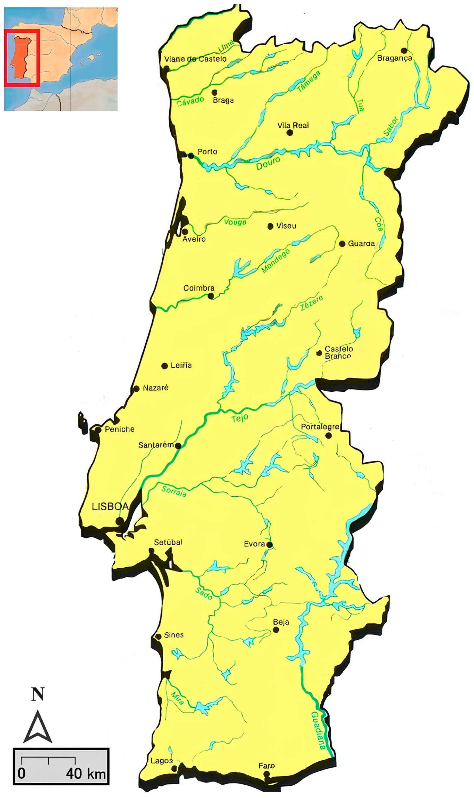
Portugal is in the Iberian Peninsula between 37° N–42° N latitude and 6° W–10° W longitude (Figure 1).
As the most western country of Europe, its frontiers are limited by Spain on its eastern and northern side, and the western and southern by the Atlantic Ocean. The country has a vast oceanic coastline both in continental terms (c. 943 km) and in insular terms (c. 667 km in the Azores and 250 km in Madeira). This geographical position is the main reason for the country’s extensive Exclusive Economic Zone of 1727.428 km2, which is the 5th largest in Europe and 20th worldwide. These facts easily allow us to infer the country’s dependence on the sea since it provides several natural resources such as minerals, salt, fish, and algae, amongst others. But the sea is also an asset with profound economic value in relation to tourist attraction and as a critical route for maritime trade [3]. Indeed, most of the Portuguese industry is located on the littoral. Besides historical reasons, this also happens because it is cheaper to trade goods or establish commerce dynamics by the ocean than by land. Several issues contribute to it, but one of the most important is the fact that maritime transport is cheaper. The other issue is that there are no railway lines linking Portugal with Europe since the typology of such railways is different from Spain and the rest of Europe. This issue forces the transshipment of goods that must be carried out from trains to trucks, making the operations by land more expensive [4,5]. This commonly represents a disinvestment in the interior of the country and results in the growing human fixation on the littoral areas [5,6].
Indeed, the most recent data on Portuguese demography show asymmetrical population densities between littoral and inland continental regions. Most of the human concentration is on the coast, while on the interior, there is a noticeable decreasing trend. This situation causes several social, cultural, environmental, and economic problems [6] that must be addressed. Natural and anthropogenic impacts, such as climate change and the pressures derived from the increasing population growth and its related activities, mean that the littoral has become a hazardous and vulnerable area for human settlement. This is specifically evident in low-lying coastal areas, since they are exposed to several impacts which are frequently taking place in mainland Portugal. It becomes particularly evident when it comes to events such as coastal erosion, land flooding or submergence, soil salinization, earthquakes, and windstorms, amongst others, which lead to social and environmental losses [7,8,9,10,11,12,13,14,15].
To enhance the understanding of social vulnerability and the subsequent human contributions to hazard occurrences and impacts in such coastal areas, it is essential to determine how human settlement in the littoral took place. Such discussion is the first step to shed light on the long-term interconnections between humans and the environment that led to the current concepts of the coastlines as hazardous landscapes. In an epoch of the so-called Anthropocene, this debate is essential to deepen the understanding of the challenging contexts of environmental changes as it is crucial to consider past practices to inform present and future solutions. This study is a contribution to such debate. It appraises the trends of the littoral human settlement in terms of a broad chronology, considering the social and natural historical attraction factors to such population trends towards the coast.
Historical analysis of Portugal’s demographic evolution was conducted both in the medieval and modern, as well as in the contemporary periods [5,16,17,18,19,20,21,22]. However, obtaining completely reliable population quantities for remote periods is an obstacle, particularly in the medieval period since historical sources only allow us to know the order of magnitude regarding population density [17]. This remains a problem for subsequent periods, but more data are available, since written sources’ quantity and quality provides it. This permits, at least, a rough calculation of the population sums and their geographical distribution [5,19]. In any case, even if not by the exact amounts, in the earliest historical times, Portuguese population quantities over time are relatively well known [23]. So, it would be expected that gravitational movements of the localities and the population distribution throughout the territory were known. In current terms, it should be known how territorial planning evolved over the centuries. As was pointed out before, it is acknowledged that presently there is an overload of population in coastal areas as opposed to a desertification of the inland, representing demographic, socioeconomic, and environmental asymmetries [6]. It is also defended that during the age of overseas expansion, the relationship between the Portuguese and the sea intensified, and there was an emergence of notable urban centers from where peoples and vessels set sail by sea to reach new territories and opportunities for enrichment [5,24]. What remains unknown are the key periods of coastal occupation, based on solid scientific evidence, which allow us to establish the rhythms of continental Portuguese coastline human settlement.
The scientific literature affirms that sheltered coastlines (estuarine and lagoonal) were very early on occupied by humans, unlike coastlines directly exposed to oceanic marine agitation, which only underwent permanent settlement at a much later stage. Accordingly, it is argued that before the leisure democratization and the beginning of seaside tourism which occurred from the 18th century forward, the exposed maritime coastlines were considered “territories of emptiness” and were, therefore, uninhabited and avoided landscapes [25]. This idea has been repeated by researchers dedicated to studying Portuguese coastal areas [10,13,26,27]. And, indeed, it is entirely reasonable to think that exposed coastlines were later occupied by humans in comparison to protected coastlines since they represented hazardous areas. Their population could face maritime storms with sea overtopping, or even occasionally, large-scale tsunamis (e.g., 1755 Lisbon earthquake). In addition, the conditions for exploiting sea and earth natural resources in such exposed coastlines were more challenging due to daily temperature fluctuations, poor terrain quality, and higher wave energy [10,11,13,15,26,27]. However, there is a lack of dedicated studies to verify such statements, and deeper analysis is needed. In the Middle Ages, the Portuguese kingdom had a relatively modest occupation of the coastline. Human settlement was made far from the littoral, at a deliberate distance from the “open sea” or exposed coastlines, safeguarding the population from such hazardous areas [16]. Human communities flourished on sheltered coastlines where maritime activities such as fishing, salt production, and sea trade were easier due to the natural conditions [28,29,30]. With the military advance through the Christian Reconquest, human settlement was maintained mainly in sheltered coastlines such as lagoonal and estuarine systems. This was at least what happened in several analyzed regions with such geomorphological facies such as the Aveiro lagoonal area [27]; the river Mondego estuary [31]; the Pederneira, Alfeizerão, and Óbidos lagoonal areas [32,33,34,35]; the Setúbal Peninsula, particularly in the Tejo River estuarine zone, the Albufeira lagoonal area, and the Sado River estuary [36]; and in the Algarve region, namely in the Alvor, Ria Formosa and the mouth of the Guadiana River [37,38] (Figure 1). After the mid-fourteenth century, with the beginning of the overseas expansion, it is claimed that population settlement in littoral areas increased. But, despite these considerations, establishing a consistent pattern of coastal occupation and its associated population density remains exceedingly challenging, at least until the census of 1527-32 [5,24]. Portuguese demographic data after such date and until the 19th century population census became more practicable though complexities persisted due to the scattered information offered by such historical sources [5,19,22]. Only after the first scientifically based Portuguese census dated from 1864, the population demography may be correctly inferred [5,39].
So, the key periods of coastal occupation have been analyzed by statistically and cartographically examining the shift in the country’s settlements and growth over a broad diachronic chronology. Using historical sources such as the county charters (forais) and population census, we seek to establish a correlation between the population density of the Portuguese coast and the intensities of the approach to such areas considering the (anthropogenic) geological events which may influence it and the results of such occupation in terms of hazard.
2. Materials and Methods
Understanding mainland Portugal’s littoralization in a broad diachronic chronology is not easy. Such a task involves handling diverse historical resources as well as using vast and dispersed scientific support and an interdisciplinary methodology. A global survey by collating and compiling the data contained in all the monastic and private documental funds was impossible due to the requirement of much greater material and human resources. Therefore, the main proxy elected was the dispersion of municipalities for most remote chronologies and human demography after the 1864 census. For such a purpose, and considering the historical source-imposed difficulties, three main chronological sections were established, in which, for the effective recognition of the municipalities and population rates, we have data at our disposal which allow us to cover the entire chronological period under observation: the county charters (forais) and the population censuses.
2.1. The County Charters (Forais)
The charters correspond to the formal recognition or pre-existence of an urban center [40]. Therefore, such historical source is very important to this analysis, since it allows us to pinpoint the most important human settlements in chronologies for which demographic rates are ambiguous or even unknown, mainly in the Middle Ages, as seen before [5,17,23,40]. This jurisdiction act could be granted by different authorities, such as religious institutions or manorial nobility. In this study, only royal charters were analyzed, since monarchs themselves have granted most of such documents [40], which allows data that covers all of the Portuguese mainland. Moreover, such charter granting reveals a royal explicit or implicit desire to “plan the territory” in the administrative, political, economic, and defense domains. Through this historical source, the first two chronological sections of this study were established:
- The first chronological section encompasses the interval between 1096 and 1321. For this period, research was conducted in manuscript sources from three documental funds of the Arquivo Nacional da Torre do Tombo (Portuguese National Archive): the livro dos forais velhos (old county charters book) [41], the Gavetas da Torre do Tombo (drawers of the Portuguese National Archive) [42], and the chancelaria régia (royal chancellery books) [43,44,45]. These sources were analyzed between the first Portuguese charters granted by count D. Henrique to the localities of Constantim de Panóias [41,42,46] (fls. 117–118; gav. 18, mç. 1, n. 12; doc. 128, pp. 161–162) and Guimarães [41] (fls. 70–71) and the last charters granted by king D. Dinis [42,45,47] (gav. 15, mç. 3, n. 12; liv. 4, fls. 91v.–92v.; doc. 96, pp. 351–356) since it was until his reign that the charter granting movement showed its greatest expression [40].
- The second chronological section focuses on D. Manuel’s reign, specifically by analyzing the Manueline charters included in the so-called books of Leitura Nova (New Reading) [48,49,50,51,52] which were granted between the years 1500, when a charter was granted to Lisbon [52] (fl. 16v.), and 1524, when the last charters of this reign were granted to the following population urban centers: Alcoutim [50] (fl. 115–116), Azinhoso [49] (fls. 63–63 v.), Celorico de Basto [48] (fls. 125 v.–142 v.), Lavre [50] (fls. 112v.–113), and Terra Galega [52] (fl. 254).
A database was created to facilitate the management of the massive amount of historical data collected. For such purpose it had the following fields: the first were named “Locality” and “Date”, in which the locality shown in the charter (with the contemporary spelling) and the date of the charter royal granting were, respectively, inscribed. There were some problems regarding homonymous localities, e.g., [41] (fls. 42–43v. and 53–53v.) which were distinguished through other descriptive elements contained in the document such as landscape descriptions, smaller places’ names, confrontations between distinct territories, rivers’ names, and others. We were also faced with the fact that the date of the first granting of some charters was unknown such as: Penajóia [53] (doc. 233, p. 260), Messejana [45,54] (livro 2, fls. 129–129v.; doc. 510, pp. 510–511), and Britiande [45,55] (livro 3, fl. 155 v.; doc. 829, pp. 567–568), which was solved by taking the first document that refers to a certain municipality as the founding diploma. A third field was made to include the indication concerning the monarch who granted the charter. Within the scope of royal grants, we chose to include charters granted by private individuals, but which were later confirmed by the monarchs. Those include, for instance, the county charter granted to Alhandra by the second bishop of Lisbon, D. Soeiro, and confirmed by king D. Sancho I in 1203 [41] (fols. 5v.–6v.) or to Alvendre, granted by the bishop of Guarda and confirmed by king D. Dinis in 1214 [45] (fols. 155v.–156v.), among others. Likewise, “mixed” charters, granted jointly by private individuals and monarchs were also included, as for instance the cases of Benavente [41] fls. 81–82 v.), Campo de Jales [41,46] (fls. 130v.–131v.; doc. 176, pp. 213–214), or Parada de Ester [56] (doc. 355, pp. 558–560). In the following entries were added data about the document’s “Sources”, a field for other “Observations”, and another for “Current jurisdiction” on municipality terms, fields that need no complementary explanations. Then, the “Latitude” and “Longitude” values were added to reference each county charter location. Finally, the field of the “Distance to ocean coast” was introduced, in which the shortest distance based on location was calculated. For this purpose, geodynamic and morphological differences between the medieval and current coastline were considered, since it was particularly during the medieval period that the main morphodynamical processes reconfigured the Portuguese littoral e.g., [10,11,27,34,35]. This process resulted in a database with 1019 entries (granted charters) that later were represented by cartographic support and through diagrams relative to the calculations of the distance from the ocean coastline.
2.2. The Censuses
The contemporary period was elected as the third chronological section since it was defined through the censuses: (a) the first census of the Portuguese population carried out in 1864 [57], which inaugurated modern censuses based on the international guidelines established in Brussels in 1853; and (b) the latest census of 2021 [58], which enabled us to obtain data on the population of the 278 mainland Portugal municipalities providing an overview of the current littoralization index.
For this period of analysis, a second database was set up to collect information from the 1864 to 2021 censuses, using 2011 version of the Official Administrative Map of Portugal (CAOP) as a reference, a cartographic resource prior to the process of parishes’ unification which occurred in 2013. The following information was collected from the 1864 census: district, municipality, parish, population, and dwellings. This information was cross-referenced with CAOP v2011, adding the fields “coddistrict”, “codmunicipality”, and “codparish” to each record. Some expected or foreseen problems occurred once the information entering process started: the extinction and creation of districts, municipalities, or parishes between 1864 and 2021 censuses, which makes it difficult to compare the results for 1864 and 2021. Whenever possible, the 1864 data was linked to the corresponding 2021 parish, even if it was in another district or municipality. The “former district”, “former municipality”, and “former parish” fields were added to preserve the original structure. The new parish name and, whenever possible, its creation and extinction date were also recorded. This process resulted in a database with 4440 records (parishes). In the next phase, information was cross-referenced with data from the 2021 census.
3. Results
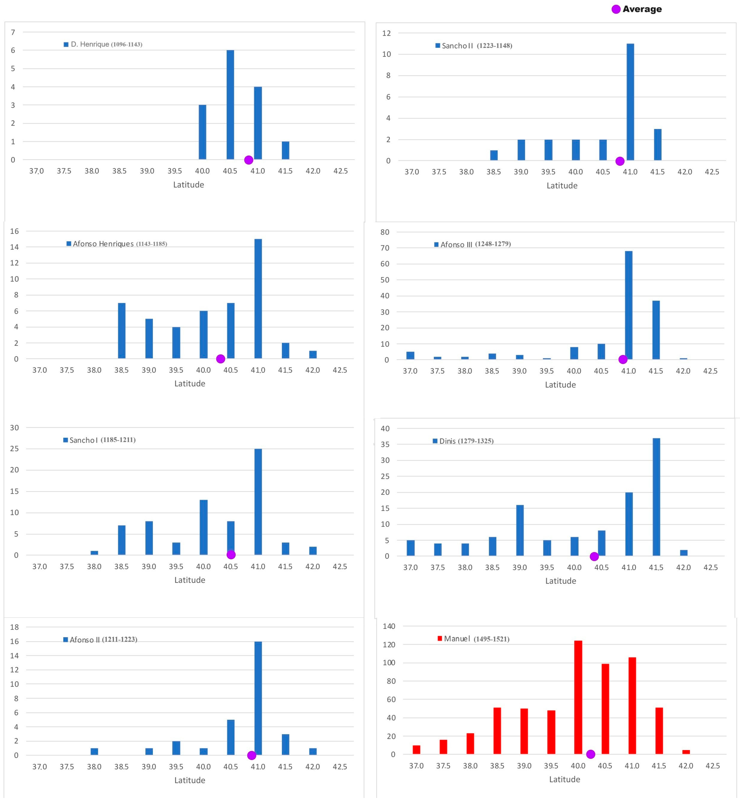
The royal charters data, interpreted through cartographic representation and histograms representing counties distribution by latitude (Figure 2) and distance from the coastline (Figure 3), made it possible to clarify the trends of the gravitational centers and the respective coastal movements of human occupation for the mentioned chronological periods (1096–1321 and 1500–1524).
The latitude distribution (Figure 2) shows strong asymmetries, with a greater incidence in northerly coordinates. The persisting main trend in almost all the reigns is 41.0° N. Only in the D. Henrique period can be seen an exception in the mode location value, which is a little further south, namely 40.5° N. This is also observed in the one corresponding to the reign of king Dinis, located a little further north at 41.5° N. It is also interesting that the distributions have a unimodal tendency (with only one peak), although the following distributions should be highlighted: in the reign of Afonso Henriques a secondary mode appears at the southern limit; in the reign of Sancho I there are two secondary modes; and in the reign of king Dinis, a secondary mode emerges between 39.0 and 39.5° N. In the Manueline period, there is a dilution of such trends, with a greater incidence to the north (40° N), certainly reflecting the more systematic charters granting.
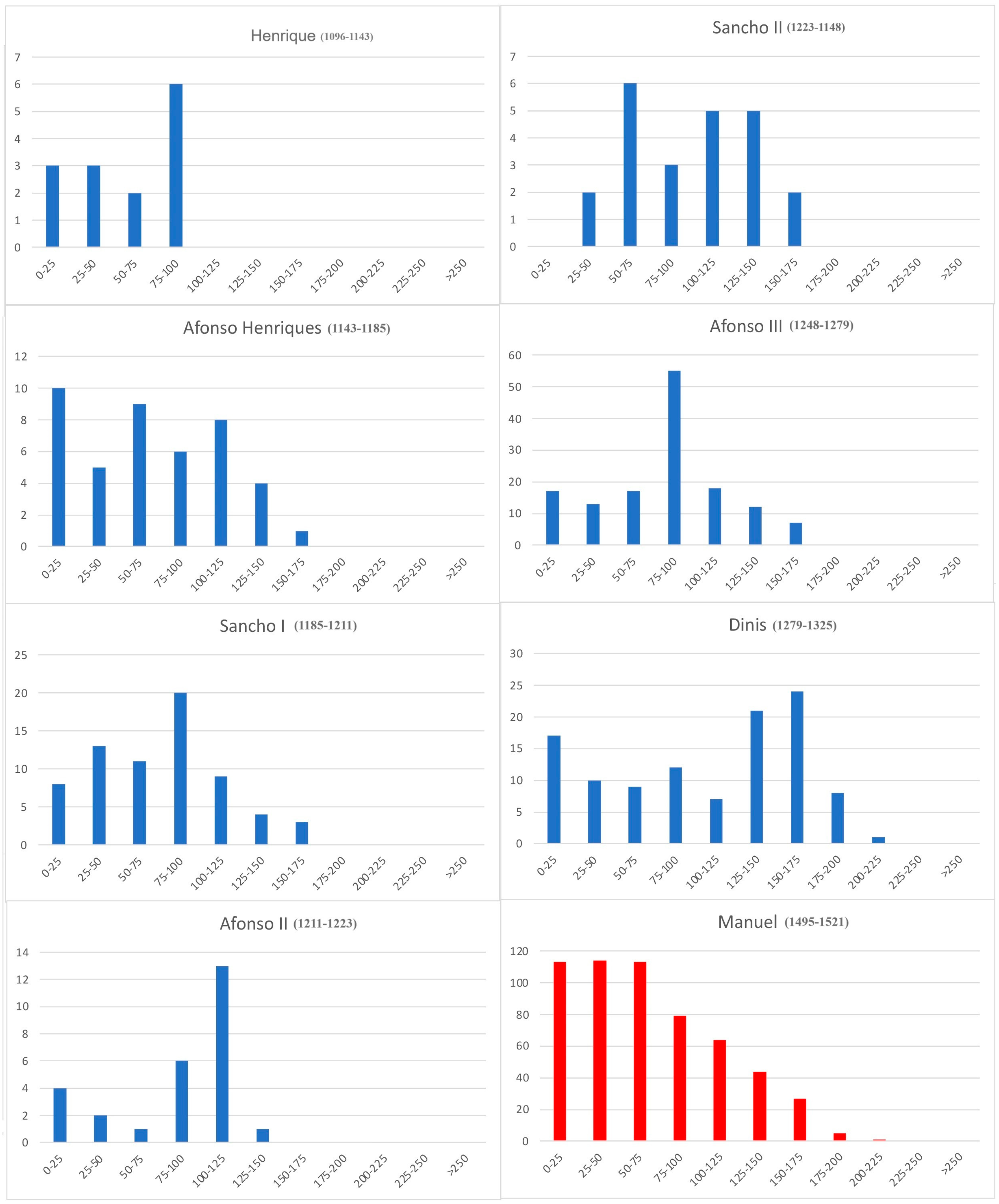
Regarding the distribution of royal charters considering distance from the coastline (Figure 3), the main mode (peak) of the distributions is systematically inland, except in the case of king Afonso Henriques reign, where the main mode is between 0 and 25 km from the coast. This main pattern varies from reign to reign and is found at the following distances from the coastline: between 75 and 100 km in the D. Henrique, Sancho I, and Afonso III periods; between 100 and 125 km in the reign of D. Afonso II; between 50 and 75 km in the reign of D. Sancho II; and between 150 and 175 km in the reign of D. Dinis. However, other modalities points must be considered. The distributions of the D. Henrique period and the reigns of king Sancho I, king Afonso II, and king Sancho II are bimodal (two peaks). In other cases, they are tri-modal, sometimes displaying a trend near the coastline, as may be seen in the reigns of king Afonso Henriques, king Afonso II, king Afonso III, and king Dinis.
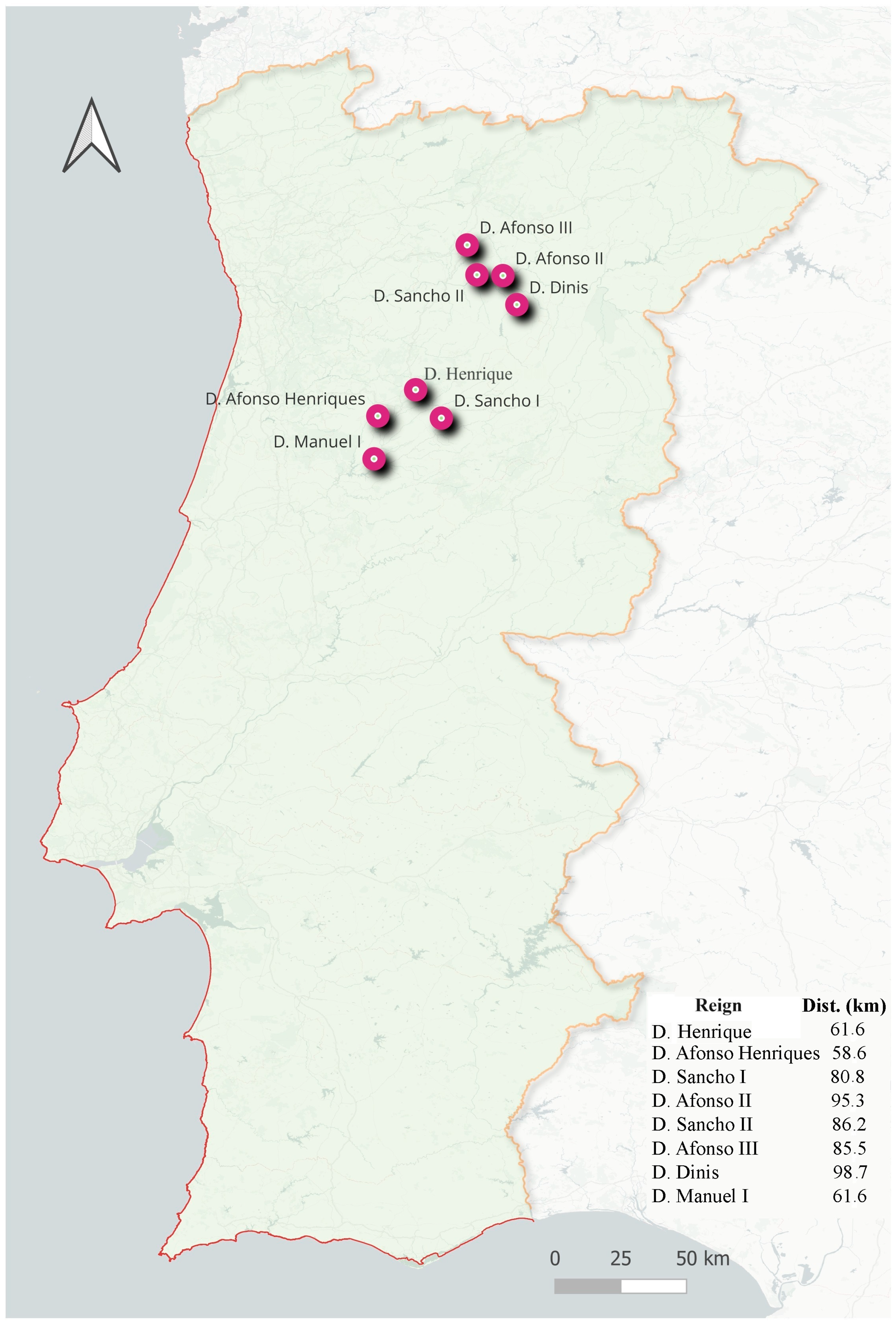
The distribution shown during the reign of king Manuel (Figure 3) illustrates the effective paradigm shift in terms of population dispersion. In fact, during this period a very wide trend appears near the coastline (columns between 0 and 75 km, with heights of 113, 114, and 113, representing the number of charters granted in that area) which decreases inland. This reflects the high littoralization that occurred at the time. Considering the compiled data from the charters, their overall median location was found to be between 58 and 98 km from the coastline (Figure 4).
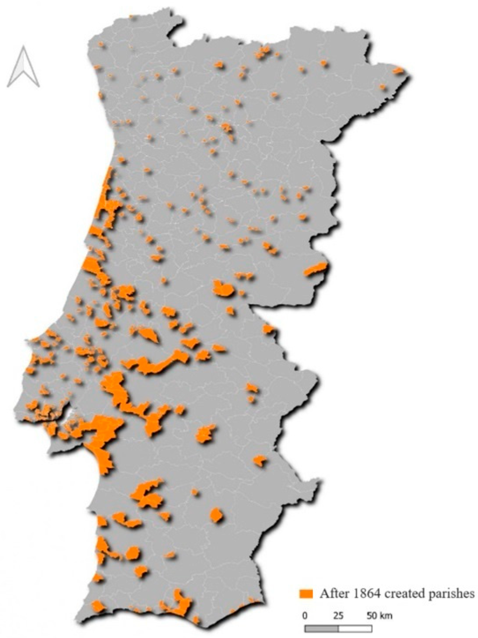
As we mentioned before regarding the censuses data, it was necessary to recreate the area of the municipalities that existed in 1864. Their territory was defined by joining the polygons of the parishes that at the time constituted such municipalities. The parishes that did not exist in 1864 were identified. The creation of these new jurisdictional territories by dividing the area of one or more parishes is a good indicator of the most dynamic areas and population growth locations. Figure 5 shows the incidence of this process in the coastal districts of the center and south, namely Aveiro, Coimbra, Santarém, Lisbon, and Setúbal, as well as in the coastal districts of Beja and Faro.
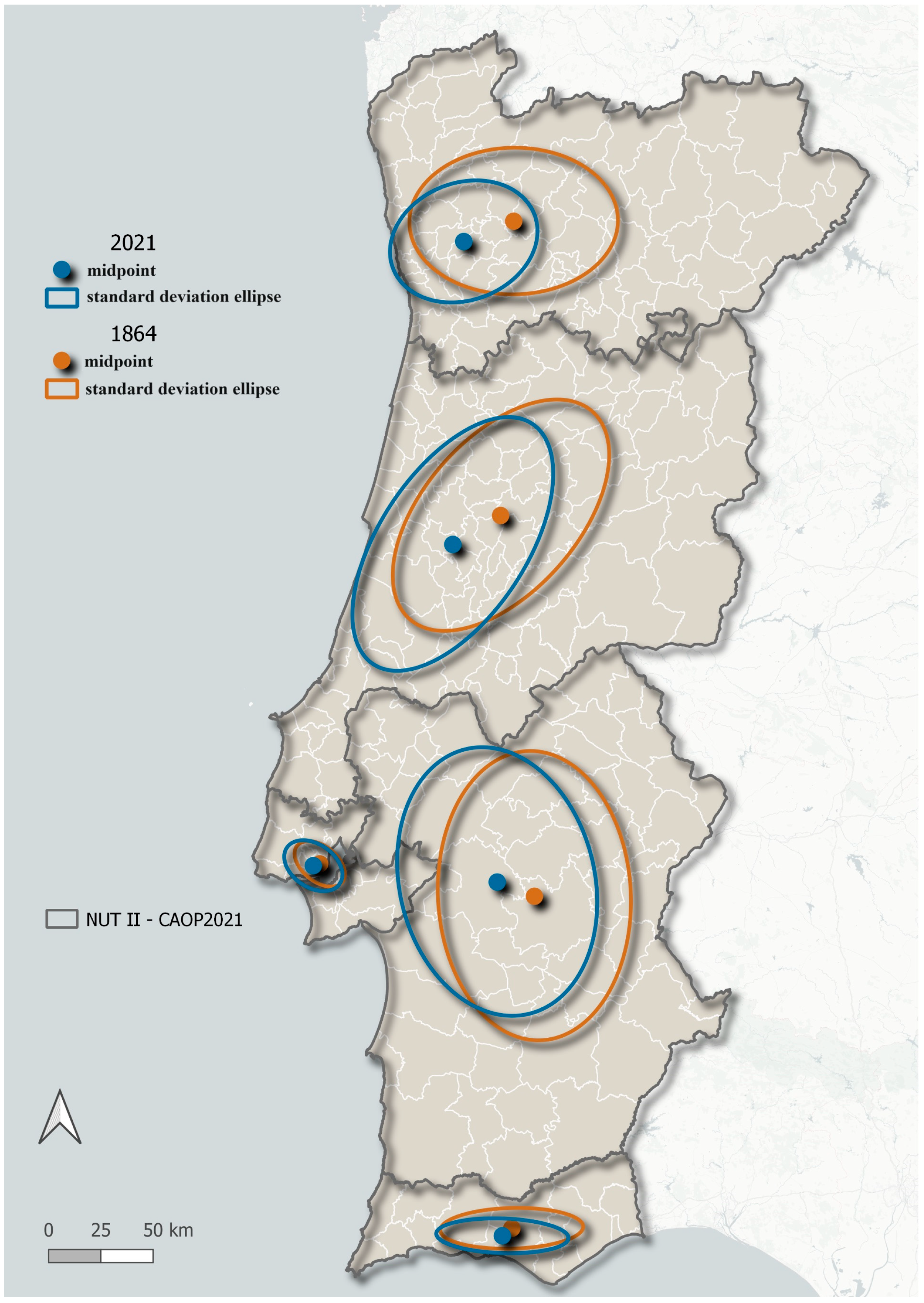
At last, the population distribution in the NUTII areas (Nomenclature of territorial units for statistical purposes) comparison between the 1864 and 2021 censuses was conducted. The population-weighted centroid was calculated, i.e., the midpoint of the population distribution in the territory of each NUTII in 1864 and 2021. The standard ellipse was also calculated, which shows the population dispersion around the centroid (Figure 6).
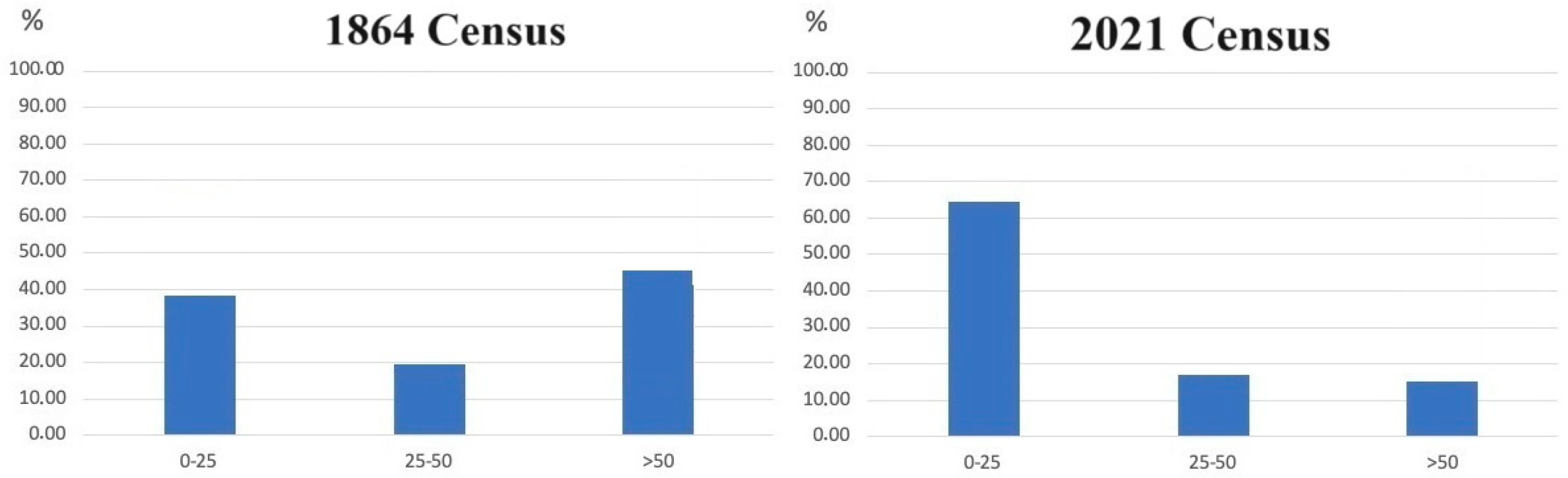
Comparing these two moments, there is a clear tendency for the centroid and the standard ellipse to move towards the coastline. In NUTII—Norte (north region), the movement was quite marked, in the direction of the Porto metropolitan area. In NUTII—Centro (central region) and NUTII—Alentejo (Alentejo region), there is also a movement towards the coast, but in the direction of the Lisbon metropolitan area. Even in the Algarve (south region), where the amplitude of the movement is not so pronounced, there is a shift of the ellipse towards the coastline. Indeed, as shown in Figure 7, in 1864 more than 35% of the population was settled within 25 km of coastline. This percentage had increased to more than 60% of population settled within 25 km of coastline in 2021.
4. Discussion
An increasing littoralization was observed. Such human collective behavior resulted from both environmental and anthropic factors. In the Middle Ages, climatic circumstances provided exceptional conditions that led to the expansion of agriculture and forestry [10]. The entitled “Medieval Warm Period”, or as recently renamed “Medieval Climatic Anomaly”, was a positive climatic phase that occurred due to a positive average NAO index (North Atlantic Oscillation) resulting in lower precipitation in a territorial stretch covering Northwest Africa, the Iberian Peninsula, and south-central Europe [59,60,61]. This climatic phase was particularly predominant during 13th and 14th centuries [60,62], which means that in Portugal it comprehended all analyzed reigns except for Portucalense county (D. Henrique) and D. Afonso Henriques (the first king of Portugal).
As human landscape exploitation activities expanded through deforestation and increasing agricultural land use, sediment deposits in river basins exponentially grew. The regular availability and supply of these terrigenous sediments to the ocean shore, then carried through the oceanic north–south drift currents, resulted in coastal construction processes. Such a dynamic has influenced the constitution or expansion of various sheltered or protected environments such as lagoonal systems [10,11,27,34,35]. Although human occupation of space favored the coast over the interior, the greatest cities were essentially nearby lagoons and fluvial areas [5,23].
With the advent of modernity, namely with the Manueline charters (forais novos), there was a tendency towards a paradigm shift, seen in a demographic progression towards the south and coastal approach. This is understandable if we consider that the search for opportunities and riches in lands beyond the sea, or in the demand and trade that came from this, seduced the population to move closer to the seaports [5,63]. Gradually, the experimentalism resulting from sea voyages to other continents allowed real or imagined fears of the sea to be overcome [64]. On the other hand, the vertigo of getting rich quickly, coupled with the impact caused by the landing of ships laden with gold and spices dissipated fear and increased the spirit of adventure [65]. A new way of looking at the sea and its risks began: nautical knowledge and ambition prevailed. To the east, the risk of invasion by Spain became less and less imminent after the restoration of Portuguese independence in 1640 [23]. In other words, while the western and southern borders (the Atlantic Ocean) increased in attraction, the eastern border (Spain) reduced the military risk and with it the socio-political risk. At this point, Portugal seemed to reverse its (imaginary) axis of inclination in favor of the coast.
Historical climatology reveals that between the 14th century and the 17th century, Western Europe experienced a sharp worsening of the climate, but this does not seem to have had a decisive impact on the trend toward Portuguese coastal occupation e.g., [62,66]. Despite the adverse weather conditions, or even because of them, the colonies’ search for financial sustainability seems to have been a solution. This topic will be analyzed more deeply in a future project.
The fact is that in the second half of the 19th century, a greater concentration of the population was already evident in the western coastal area of Portuguese territory [5]. The construction of new roads and the development of the railway, especially along the coast, made the coastal areas more accessible. The fashion for sea bathing as a health therapy imported from northern Europe [25] arrived in Portugal, albeit about a century late [26]. As is normal, the middle classes tended to imitate the behavior of the social elite and there was soon an appreciation of the beach as a place of leisure and well-being, which intensified even more with the generalization of holiday entitlement to the entire population [10,13,26]. We reached the middle of the 20th century with a real beach paranoia. Everyone wanted a place to relax by the sea and maritime tourism became an important pillar of the Portuguese economy. The construction of Faro Airport in the Algarve in 1965 is absolute proof of this. At the same time, the advance of science and technology, especially after the Second World War, as well as the climate of peace in Europe, gave mankind a false sense of supremacy over nature. The notion of risk has faded with this sense of human invincibility and so the legacy of the historical memory of natural disasters, due to human and natural causes, has been subordinated. And so, we come to the present where 82% of the population lives less than 50 km from the sea and about 60% in a narrow strip of less than 25 km of the Atlantic Ocean (Figure 7).
A large part of the buildings was built in areas at risk and the Portuguese state budget has spent millions of euros defending coastlines that are in a process of erosion that is practically irreversible [11,14,15]. It should be added that scientific reports have warned of the danger of permanent occupation of some sections of the Portuguese coastline, especially given the impact of climate change on the coastal zone [15]. So far, there have been few cases of mitigating the problem by, for example, relocating rigid structures to a safe retreat zone. Investment has been made in the construction and reinforcement of longitudinal and seafront walls which always show the same behavior: accumulation at updrift and erosion at downdrift [15,67]. On the other hand, only around 15% of the population lives inland (Figure 7), which leads to the dangerous desertification of the area [5] that results, for example, in a lack of land-use planning and surveillance during the summer fire season. These are all recurring findings that have been studied and scientifically validated year after year [15]. So, what we can conclude is that the craze for overcrowding Portugal’s coastal zone is a collective, conscious, and scientifically informed risk-taking behavior. To that extent, it is much more than a coastal approach. It is a choice of coastal zones political managers.
5. Conclusions
This work aims to deepen the understanding of human settlement trends along the coastline within a comprehensive chronological context. The lack of studies on the matter justifies the funding of an exploratory one-year research project, on which this paper was based. The authors believe that subsequent projects will be approved which will allow them to broaden the scope and detail of the analysis. However, some main ideas can be yet emphasized as follows:
- (1)
- During the early Middle Ages, i.e., the formation, independence, and establishment of Portuguese borders, the permanent settlement of human communities did not take place on open coastlines, but only in lagoons and estuarine areas.
- (2)
- With modern times and the intensification of Portuguese expansion, there was a timid approach to the coastline.
- (3)
- The second half of the 19th century saw a paradigm shift with a clear littoralization of mainland Portugal.
- (4)
- Today we see a country with an overwhelming coastal occupation, with around 80% of the population based in a strip of land less than 50 km from the coast.
Of course, this coastal demographic concentration was carried out without respect for the occupation of risk zones, which increases the vulnerability of people and property in some segments of beaches, which are already very exposed and eroded. At the same time, the interior of Portugal seems to be showing a worsening trend towards desertification. Details of the weaknesses of this type of land use will be studied in new projects that we believe will be subsidized and worked on. Nevertheless, it is believed that a first step has been taken towards filling a conceptual scientific gap and the results can be compared with other case studies from countries with similar geographical and historical characteristics, providing policymakers with a scientific basis for increasingly informed decision-making.
Author Contributions
Conceptualization, M.R.B. and O.N.A.P.; Methodology, M.R.B. and O.N.A.P.; Software, F.S.; Validation, J.A.D.; Data curation, A.F. and S.L.; Writing—original draft, M.R.B. and O.N.A.P.; Writing—review & editing, M.R.B. and O.N.A.P. All authors have read and agreed to the published version of the manuscript.
Funding
The authors acknowledge the financial support of Fundação para a Ciência e Tecnologia (FCT) given to Litoralias project—https://litoralias.pt/ (accessed on 14 March 2024)—through the strategic project granted to CITCEM-Transdisciplinary Research Centre «Culture, Space and Memory» R&D unit of the University of Porto (UIDB/04059/2020). This study was also funded by Fundação para a Ciência e Tecnologia (FCT, Portugal), through the strategic projects UIDB/04292/2020—https://doi.org/10.54499/UIDB/04292/2020 (accessed on 14 March 2024) and UIDP/04292/2020—https://doi.org/10.54499/UIDP/04292/2020 (accessed on 14 March 2024) granted to MARE—Marine and Environmental Sciences Centre, and the project LA/P/0069/2020—https://doi.org/10.54499/LA/P/0069/2020 (accessed on 14 March 2024) granted to the Associate Laboratory ARNET—Aquatic Research Network.
Data Availability Statement
Data is contained within the article.
Acknowledgments
The authors would like to thank João Viegas for revising and improving the English.
Conflicts of Interest
The authors declare no conflicts of interest.
References
- Witze, A. Geologists reject the Anthropocene as Earth’s new epoch—After 15 years of debate. Nature 2024. epub ahead of print. [Google Scholar] [CrossRef]
- Fressoz, J.B.; Bonneuil, C. The Shock of the Anthropocene the Earth, History and Us; Verso Books: London, UK, 2016; pp. 24–26. [Google Scholar]
- Silva, J.C.V.F. A Função do Mar No Desenvolvimento de Portugal: Uma Análise Estratégica. Ph.D. Thesis, University of Lisbon, Lisbon, Portugal, 2020. [Google Scholar]
- Cruz, C.O.; Costa, Á.; Sarmento, J.M.; Sousa, V.F.; Januário, J.F. Transport Systems in Portugal Analysis of Efficiency and Regional Impact, 1st ed.; Fundação Francisco Manuel dos Santos: Lisboa, Portugal, 2021. [Google Scholar]
- Rodrigues, T. História da População Portuguesa: Das Longas Permanências à Conquista da Modernidade, 1st ed.; CEPESE/Edições Afrontamento: Porto, Portugal, 2009; pp. 423–446. [Google Scholar]
- Instituto Nacional de Estatística. Retrato Territorial de Portugal, 1st ed.; Instituto Nacional de Estatística: Lisboa, Portugal, 2019; 171p. Available online: https://www.ine.pt/xurl/pub/358634995 (accessed on 6 March 2024).
- Nicholls, R.J.; Wong, P.P.; Burkett, V.; Woodroffe, C.D.; Hay, J. Climate change and coastal vulnerability assessment: Scenarios for integrated assessment. Sustain. Sci. 2008, 3, 89–102. [Google Scholar] [CrossRef]
- Neumann, B.; Athanasios, T.V.; Zimmermann, J.; Nicholls, R.J. Future Coastal Population Growth and Exposure to Sea-level Rise and Coastal Flooding—A Global Assessment. PLoS ONE 2015, 10, e0118571. [Google Scholar] [CrossRef] [PubMed]
- Oppenheimer, M.; Glavovic, B.C.; Hinkel, J.; Van de Wal, R.; Magnan, A.K.; Abd-EIgawad, A.; Cai, R.; Cifuentes-Jara, M.; DeConto, R.M.; Ghosh, T.; et al. Sea Level Rise and Implications for Low-Lying Islands, Coasts and Communities. In IPCC Special Report on the Ocean and Cryosphere in a Changing Climate; Pörtner, H.O., Roberts, D.C., Masson-Delmotte, V., Zhai, P., Tignor, M., Poloczanska, E., Mintenbeck, K., Alegría, A., Nicolai, M., Okem, A., et al., Eds.; Cambridge University Press: Cambridge, UK; New York, NY, USA, 2019; pp. 321–445. [Google Scholar] [CrossRef]
- Dias, J.A. Evolução da zona costeira portuguesa: Forçamentos antrópicos e naturais. Rev. Encontros Científicos-Tur. Gestão Fiscalidade 2005, 1, 7–27. [Google Scholar]
- Dias, J.A.; Ferreira, Ó.; Pereira, A.R. Estudo Sintético de Diagnóstico da Geomorfologia e da Dinâmica Costeira dos Troços Costeiros Entre Espinho e a Nazaré; Esamim–Estudos de Ambiente e Informática, Lda: Lisbon, Portugal, 1994. [Google Scholar]
- Freitas, J.G.; Dias, J.A. 1941 windstorm effects on the Portuguese Coast. What lessons for the future? J. Coast. Res. 2013, 65, 714–719. [Google Scholar] [CrossRef]
- Freitas, J.G.; Dias, J.A. A historical view on coastal erosion: The case of Furadouro (Portugal). Environ. Hist. 2017, 23, 217–252. [Google Scholar] [CrossRef]
- Ferreira, J.C.; Cardona, F.S.; Jóia Santos, C.; Tenedório, J.A. Hazards, Vulnerability, and Risk Analysis on Wave Overtopping and Coastal Flooding in Low-Lying Coastal Areas: The Case of Costa da Caparica, Portugal. Water 2021, 13, 237. [Google Scholar] [CrossRef]
- Santos, F.D.; Lopes, A.M.; Moniz, G.; Ramos, L.; Taborda, R. Grupo de Trabalho do Litoral—Gestão da Zona Costeira: O Desafio da Mudança; Santos, F.D., Penha-Lopes, G., Lopes, A.M., Eds.; APA: Lisbon, Portugal, 2017. [Google Scholar]
- Marques, A.H. Demografia. In Dicionário de História de Portugal; Serrão, J., Ed.; Livraria Figueirinhas: Porto, Portugal, 1987; Volume 2, pp. 281–286. [Google Scholar]
- David, H. A população portuguesa na Idade Média: Uma revisão bibliográfica. Popul. Soc. 1995, 1, 87–91. [Google Scholar]
- Nazareth, J.M. Demografia: A Ciência da População, 6th ed.; Editorial Presença: Lisboa, Portugal, 2004; 272p. [Google Scholar]
- Silveira, L.N.E. Os Recenseamentos da População Portuguesa de 1801 e 1849: Edição crítica, 1st ed.; Instituto Nacional de Estatística: Lisboa, Portugal, 2001; Volume 3.
- Ferro, J.P. A População Portuguesa no Final do Antigo Regime (1750–1815), 1st ed.; Editorial Presença: Lisboa, Portugal, 1995; 170p. [Google Scholar]
- Galego, J.; Daveau, S. O Numeramento de 1527–1532. Tratamento Cartográfico. In Memórias do Centro de Estudos Geográficos, 1st ed.; Centro de Estudos Geográficos: Lisboa, Portugal, 1986; Volume 9, 118p. [Google Scholar]
- Sousa, F.A.P. A População Portuguesa nos Inícios do Século XIX. Ph.D. Thesis, University of Porto, Porto, Portugal, 1979. [Google Scholar]
- Mattoso, J. História de Portugal; Editorial Estampa: Lisboa, Portugal, 1997–2001; Volumes 1–8, pp. (vol. II: 199–207, 275–301; vol. III: 177–195, 206–217; vol. IV: 43–62; vol. V: 365–377; vol. VI: Passim; vol. VII: 21–31; vol. VIII: 131–135). [Google Scholar]
- Rodrigues, T. As Estruturas Populacionais. In História de Portugal; Mattoso, J., Ed.; Editorial Estampa: Lisboa, Portugal, 1997; Volume 3, pp. 179–217. [Google Scholar]
- Corbain, A. L’Avenement des Loisirs 1850–1960, 1st ed.; Aubier: Paris, France, 1995. [Google Scholar]
- Freitas, J.G. O Litoral Português na Época Contemporânea: Representações, Práticas e Consequências. Os Casos de Espinho e do Algarve (c. 1851 a c. de 1990). Ph.D. Thesis, University of Lisbon, Lisbon, Portugal, 2010. [Google Scholar]
- Bastos, M.R. O Baixo Vouga em Tempos Medievos: Do Preâmbulo da Monarquia aos Finais do Reinado de D. Dinis, 1st ed.; Verlag: Saarbrücken, Germany, 2015; 400p. [Google Scholar]
- Sampaio, A. As Póvoas Marítimas. In Estudos Históricos e Económicos, 2nd ed.; Sampaio, A., Ed.; Editorial Vega: Lisboa, Portugal, 1979; Volume 2, 277p. [Google Scholar]
- Andrade, A.A. A estratégia régia em relação aos portos marítimos no Portugal medieval: O caso da fachada Atlântica. In Ciudades y Villas Portuarias del Atlántico en La Edad Media. Encuentros Internacionales del Medievo, 1st ed.; Bolumburu, B.A., Telechea, J.A.S., Eds.; Govierno de la Rioja—Instituto de Estudios Riojanos: Logrõno, Spain, 2005; pp. 57–89. [Google Scholar]
- Moreno, H.B. A navegação e a Actividade Mercantil no Entre-Douro-E-Minho. Rev. Fac. Let. 1992, 9, 9–24. [Google Scholar]
- Coelho, M.H. O Baixo Mondego nos Finais da Idade Média (Estudo de História Rural), 1st ed.; Faculdade de Letras da Universidade de Coimbra: Coimbra, Portugal, 1989; Volume 1, 727p. [Google Scholar]
- Henriques, M.V.F.J.R. A Faixa Litoral Entre a Nazaré e Peniche. Unidades Geomorfol Ógicas e Dinâmica Actual dos Sistemas Litorais. Ph.D. Thesis, University of Évora, Évora, Portugal, 1996. [Google Scholar]
- Henriques, M.V.F.J.R. O Litoral dos Coutos de Alcobaça. Evolução sedimentar e histórica da Lagoa da Pederneira. In Mosteiros Cisterciences. História, arte e Património, 1st ed.; Carreiras, J., Ed.; Jolis: Alcobaça, Portugal, 2013; Volume 3, pp. 423–442. [Google Scholar]
- Dias, J.M.A. A história da evolução do litoral português nos últimos vinte milénios. In Evolução Geohistórica do Litoral Português e Fenómenos Correlativos: Geologia, História, Arqueologia e Climatologia: Actas do Colóquio, 1st ed.; Tavares, A.A., Tavares, M.J.F., Cardoso, J.L., Eds.; Universidade Aberta: Lisboa, Portugal, 2004; pp. 157–170. [Google Scholar]
- Dias, J.A. Alguns exemplos de rápida evolução costeira em Portugal. In O Futuro do Ambiente da Península Ibérica: As Lições do Passado Geológico Recente, 1st ed.; Bosky, T., Moura, D., Gomes, A., Eds.; CIMA: Faro, Portugal, 2009; pp. 17–21. [Google Scholar]
- Oliveira, J.A. Na Península de Setúbal, em Finais da Idade Média—Organização do Espaço, Aproveitamento dos Recursos e Exercício do Poder. Ph.D. Thesis, Nova University Lisbon, Lisbon, Portugal, 2008. [Google Scholar]
- Dias, J.M.A. Aspectos Geológicos do Litoral Algarvio. Geonovas 1988, 10, 113–128. [Google Scholar]
- Iria, A. O Algarve e os Descobrimentos. In Descobrimentos Portugueses—Documentos Para a Sua História, 2nd ed.; Silva Marques, J.M., Ed.; Instituto Nacional de Investigação Científica: Lisboa, Portugal, 1988; Volume 2 (I), 399p. [Google Scholar]
- Pinto, M.L.R.; Rodrigues, T. A Evolução da População ao Longo do Século XIX—Uma Perspectiva Global. Rev. Fórum Sociol. 1993, 3, 145–172. [Google Scholar]
- Reis, A.M. História dos Municípios (1050–1383), 2nd ed.; Livros Horizonte: Lisboa, Portugal, 2015; 619p. [Google Scholar]
- Arquivo Nacional Torre do Tombo. Leitura Nova, Livro 42, Livro de Forais Velhos.
- Arquivo Nacional Torre do Tombo. Gavetas.
- Arquivo Nacional Torre do Tombo. Chancelaria Régia, D. Afonso II, Livros 1 e 2.
- Arquivo Nacional Torre do Tombo. Chancelaria Régia, D. Afonso III, Livros 1, 2 e 3.
- Arquivo Nacional Torre do Tombo. Chancelaria Régia, D. Dinis, Livros 1, 2, 3, 4 e 5.
- Ventura, L.; Oliveira, A.R. Chancelaria de D. Afonso III, Livros II e III, 1st ed.; Imprensa da Universidade de Coimbra: Coimbra, Portugal, 2011; 403p. [Google Scholar]
- Coelho, M.H.; Rocha, A.R. Forais de D. Dinis, 1st ed.; Imprensa Nacional—Casa da Moeda: Lisboa, Portugal, 2022; 429p. [Google Scholar]
- Arquivo Nacional Torre do Tombo. Leitura Nova, livro 43, Livro dos Forais Novos de Entre Douro e Minho.
- Arquivo Nacional Torre do Tombo. Leitura Nova, livro 44, Livro dos Forais Novos de Trás-os-Montes.
- Arquivo Nacional Torre do Tombo. Leitura Nova, livro 45, Livro dos Forais Novos de Entre Tejo e Odiana.
- Arquivo Nacional Torre do Tombo. Leitura Nova, livro 46, Livro dos Forais Novos da Beira.
- Arquivo Nacional Torre do Tombo. Leitura Nova, livro 47 Livro dos Forais Novos da Estremadura.
- Ventura, L.; Oliveira, A.R. Chancelaria de D. Afonso III, Livro I, 1st ed.; Imprensa da Universidade de Coimbra: Coimbra, Portugal, 2006; Volume 1, 470p. [Google Scholar]
- Marreiros, R. Chancelaria de D. Dinis, Livro II, 1st ed.; Palimage/Centro de História da Sociedade e da Cultura: Viseu/Coimbra, Portugal, 2012; 563p. [Google Scholar]
- Marreiros, R. Chancelaria de D. Dinis—Livro III, 1st ed.; Imprensa da Universidade de Coimbra: Coimbra, Portugal, 2019; Volume 2, 623p. [Google Scholar]
- Marreiros, R. Chancelaria de D. Dinis—Livro III, 1st ed.; Imprensa da Universidade de Coimbra: Coimbra, Portugal, 2019; Volume 1, 617p. [Google Scholar]
- Estatística de Portugal. Censo no 1º de Janeiro de 1864. População, 1st ed.; Imprensa Nacional: Lisboa, Portugal, 1868; 314p.
- INE—Instituto Nacional de Estatística. Censos 2021: Resultados Definitivos, 1st ed.; Instituto Nacional de Estatística: Lisboa, Portugal, 2022; 131p.
- Trouet, V.; Esper, J.; Graham, N.; Baker, A.; Scorse, J.D.; Franck, D.C. Persistent Positive North Atlantic Oscillation Mode Dominated the Medieval Climate Anomaly. Science 2009, 324, 78–80. [Google Scholar] [CrossRef] [PubMed]
- Ortega, P.; Lehner, F.; Swingedouw, D.; Massondelmotte, V.; Raible, C.; Casado, M.; You, P. A model-tested North Atlantic Oscillation reconstruction for the past millennium. Nature 2015, 523, 71–74. [Google Scholar] [CrossRef] [PubMed]
- Moreno, A.; Pérez, A.; Frigola, J.; Nieto-Moreno, V.; Rodrigo-Gámiz, M.; Martrat, B.; González-Sampériz, P.; Morellón, M.; Martín-Puertas, C.; Corella, J.P.; et al. The Medieval Climate Anomaly in the Iberian Peninsula reconstructed from marine and lake records. Quat. Sci. Rev. 2012, 43, 16–32. [Google Scholar] [CrossRef]
- Mann, M.E.; Zhihua, Z.; Scott, R.; Raymond, S.B.; Hughes, M.K.; Shindell, D.; Ammann, C.; Faluvegi, G.; Ni, F. Global Signatures and Dynamical Origins of the Little Ice Age and Medieval Climate Anomaly. Science 2009, 326, 1256–1260. [Google Scholar] [CrossRef] [PubMed]
- de Oliveira Marques, A.H.; Dias, J.J.A. Atlas Histórico de Portugal e do Ultramar Português, 1st ed.; Centro de Estudos Históricos: Lisboa, Portugal, 2003; 604p. [Google Scholar]
- Almeida, O.T. O Século dos Prodígios. A Ciência no Portugal da Expansão, 1st ed.; Quetzal Editores: Lisboa, Portugal, 2018; 388p. [Google Scholar]
- Godinho, V.M. Os Descobrimentos e a Economia Mundial, 2nd ed.; Editorial Presença: Lisboa, Portugal, 1981–1983; Volume 4, pp. 227, 290, 292, 358. [Google Scholar]
- Bastos, M.R.; Pereira, O.N.A.; Dias, J.A. Climate Change and the Aveiro’s Lagoon (R)evolution. Acad. Lett. 2021, 3436, 1–7. [Google Scholar] [CrossRef]
- Lacasta, N.; Ribeiro, A.S. Plano de Ação Litoral XXI, 1st ed.; Agência Portuguesa do Ambiente: Lisboa, Portugal, 2017; 120p.
Figure 1.
Portugal’s location in the Iberia Peninsula, main rivers, and cities.

Figure 2.
Royal charter distribution by latitude. X-axis: latitude; Y-axis: number of historical documents.
Figure 2.
Royal charter distribution by latitude. X-axis: latitude; Y-axis: number of historical documents.

Figure 3.
Royal charter distribution by distance from the coastline. X-axis: distance from the coastline; Y-axis: number of historical documents.
Figure 3.
Royal charter distribution by distance from the coastline. X-axis: distance from the coastline; Y-axis: number of historical documents.

Figure 4.
Royal charters’ median distance from the coastline.

Figure 5.
After 1864 created parishes.

Figure 6.
Population distribution by NUTII (1864 and 2021 censuses).

Figure 7.
Population percentual distribution by distance from the coastline in 1864 and 2021 censuses. X-axis: distance from the coastline; Y-axis: population percentage.
Figure 7.
Population percentual distribution by distance from the coastline in 1864 and 2021 censuses. X-axis: distance from the coastline; Y-axis: population percentage.

Disclaimer/Publisher’s Note: The statements, opinions and data contained in all publications are solely those of the individual author(s) and contributor(s) and not of MDPI and/or the editor(s). MDPI and/or the editor(s) disclaim responsibility for any injury to people or property resulting from any ideas, methods, instructions or products referred to in the content. |
© 2024 by the authors. Licensee MDPI, Basel, Switzerland. This article is an open access article distributed under the terms and conditions of the Creative Commons Attribution (CC BY) license (https://creativecommons.org/licenses/by/4.0/).
Share and Cite
MDPI and ACS Style
Bastos, M.R.; Pereira, O.N.A.; Ferreira, A.; Salgado, F.; Lira, S.; Dias, J.A. Approach and Permanent Human Occupation of Mainland Portugal Coastal Zone (1096–2021). Water 2024, 16, 1110. https://doi.org/10.3390/w16081110
AMA Style
Bastos MR, Pereira ONA, Ferreira A, Salgado F, Lira S, Dias JA. Approach and Permanent Human Occupation of Mainland Portugal Coastal Zone (1096–2021). Water. 2024; 16(8):1110. https://doi.org/10.3390/w16081110
Chicago/Turabian StyleBastos, Maria Rosário, Olegário Nelson Azevedo Pereira, Antero Ferreira, Filipe Salgado, Sérgio Lira, and João Alveirinho Dias. 2024. "Approach and Permanent Human Occupation of Mainland Portugal Coastal Zone (1096–2021)" Water 16, no. 8: 1110. https://doi.org/10.3390/w16081110
Note that from the first issue of 2016, this journal uses article numbers instead of page numbers. See further details here.