Abstract
Malaysia can accurately analyse flood patterns and susceptible forecast areas and allocate resources as efficiently as possible by leveraging geographic information systems (GIS). Authorities can execute data-driven plans for robust flood control and quick catastrophe response because of this technology. However, in Malaysia, public authorities adequately apply GIS, researchers often limit the use of GIS applications to study natural disasters, and communities find GIS challenging to learn and adopt. By producing flood risk mapping using GIS applications that make it easy for the communities to understand the situation, the government and communities can implement programs to mitigate the impacts of natural hazards. Reviewing the available literature on the use of GIS applications in assessing natural hazards, this study found that GIS applications effectively provide flood risk mapping and positively impact natural disaster management to ensure that the worst impacts of natural hazards can be avoided. Moreover, this study revealed the importance of GIS applications and technologies in managing natural hazards in communities to make them better prepared for disaster management. Based on the scientific research, 12 articles were identified to analyse flood management activities in Malaysia. Therefore, the government and relevant agencies should take advantage of the appropriate use of GIS in managing natural disasters and educate the population about applying GIS so that present and future generations can gain this knowledge earlier and use it better in mitigating disaster risks.
1. Introduction
A natural disaster is an event that creates tragedies that occur involving nature, according to Coburn [1]. Natural hazards, which frequently result in death and illness, can arise when a hazard overwhelms highly affected groups. According to researchers [2], a natural hazard damages normal life patterns, harms human life and social structures and causes the emergence of community needs. A natural disaster is a series of events that cause casualties and damage and the loss of property, infrastructure, essential services, or means of life on a scale beyond standard capacity [3].
More than 300 natural disasters have struck the world each year for the past ten years, impacting millions and costing billions of USD [2]. A coordinated disaster response, recovery, prevention, and preparation plan should be built based on disaster cycles [4]. Concerns arise about the possibility of communicable diseases, food and nutrition, shelter, access to clean water, and adequate sanitation, which could all impact the management of a natural hazard and slow recovery [4]. Natural disasters can impact human life negatively, and several natural hazards can occur, including geological, biological, hydrological, meteorological, and hydrological disasters [5,6].
Geological risks are defined as geologic impacts or events that arise due to natural or human processes and cause environmental harm and losses in human life and property [7,8]. Human activities, often the outcome of interactions between humans and nature, are not only limited by the natural environment but are also linked to the distribution and shifting patterns of geologic disasters in space and time. Other common geological dangers include mass movements, landslides, seismic activity, and volcanic hazards [9]. A landslide at the Father’s Organic Farm campsite in Batang Kali, Selangor, in 2021 claimed 31 lives, including those of children [10]. Geological hazards, which are the movement of masses like boulders and sand from upstream to downstream, are linked to the incidence of landslides [11].
Flooding is a serious concern in Malaysia; in recent years, it has caused over 90,000 people to be displaced, as well as several fatalities (https://apnews.com/article/malaysia-floods-monsoon-rains-08532d729eb70026e968b1ee34b029c6, access date 27 December 2024). Malaysia has been strengthening its efforts to mitigate floods and incorporating techniques for adapting to climate change to tackle these issues. In these endeavours, GIS has proven to be indispensable by allowing for accurate flood risk mapping and real-time monitoring. This development has been made possible in large part by international cooperation. For example, Malaysia’s flood management systems have been strengthened with assistance from the United Nations Development Programme (UNDP) [12]. The World Bank has also offered technical help to increase disaster resilience. By making GIS technology easier to integrate into national initiatives, these partnerships have improved Malaysia’s ability to anticipate, prepare for, and effectively respond to flood dangers.
Floods and droughts are examples of extreme events, behaviours, and water distributions that are considered hydrological hazards [13,14]. A confluence of physical processes that interact and compound over various spatial and temporal scales usually results in hydrological risks. In Shah Alam, Selangor, for instance, flooding occurred on 26 February 2006 due to excessive rainfall within a specific period [15]. One possible explanation is that high river water cannot go straight to the sea when it collides with high tides.
The final risks are weather-related dangers, which are the most deadly since they can kill many people, seriously damage man-made infrastructure, and negatively impact a nation’s chances for socio-economic growth [16]. Severe storms, hurricanes, tornadoes, droughts, heat waves, cold spells, and extreme temperatures are a few examples of weather-related risks [17].
One nation where natural disasters occur annually is Malaysia. Natural disasters include heavy rains, landslides, floods, and drought conditions. This is due to Malaysia’s status as an equatorial nation (https://www.penerangan.gov.my/, accessed on 21 October 2024). Both natural and man-made elements can cause natural disasters. Flooding happens frequently, particularly in East Coast regions like Terengganu and Kelantan. One unforeseen circumstance occurred on 17 December 2021, when Shah Alam, the state capital of Selangor, faced flooding [18]. The government’s inability to respond to save the victims of this catastrophe also caused many issues because such events were not anticipated, particularly in Shah Alam, which is a metropolitan and developed area in Selangor [19]. Consequently, the socio-economic status of the nation may be affected by flood occurrences like this. Because Kuala Lumpur and Selangor are two of the most significant contributors to the GDP, a vital flood disaster to hit the Klang Valley, for example, will impact the nation’s economic recovery if it lasts for a long time [20]. Additionally, the consequences of the floods will prevent the residents from performing their regular tasks as usual, affecting their comfort and living standards. Thus, scientists and government agencies should move forward with plans to solve and stop this issue from occurring again (Figure 1).
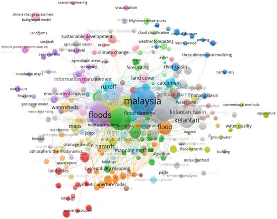
Figure 1.
Co-occurrence-based authors’ keywords in VOSviewer based on Scopus data from 2000 to 2023.
Malaysia’s GIS skills with regard to flood management have been substantially enhanced by international partnerships. The World Bank and the United Nations Development Programme (UNDP) have funded projects that have emphasized technology transfer, capacity building, and improving GIS infrastructure. These collaborations have led to sophisticated flood monitoring systems that use sensor networks, satellite imaging, and GIS data analytics to more accurately forecast flood events.
Community-based flood preparedness projects are another example of how GIS applications have developed in Malaysia. Local communities are involved in flood risk assessment and reporting through mobile GIS tools and applications. Public knowledge is raised, and more robust flood mitigation techniques are guaranteed through this participatory method. All things considered, the integration of GIS technology into Malaysia’s flood hazard management is a noteworthy development in the mitigation of catastrophe risk. To fully realize GIS’s potential in protecting communities from flood disasters, it will be necessary to make consistent investments in its infrastructure, hire qualified staff, and cooperate across agencies. Hence, this review explores the usefulness of GIS applications in natural disaster management, including floods in Malaysia.
2. Article Review Method
A review of the literature served as the basis for the methodology. The Scopus and Web of Science databases were searched. Next, a more thorough search was conducted from 2004 to the present using the BMC Public Health and Willey Online Library databases. The search terms for the articles broadly included floods, GIS, disaster, and Malaysia. The detailed search strategy for the flood-related analysis in Malaysia included search engines like PubMed, Web of Science, MEDLINE, SciELO Citation Index, and Scopus database. Some common keywords like flood, inundation, disaster, GIS, hazards, and water logging were used. The keywords were applied to the database to identify articles like flood, Malaysia, and disaster.
There were twelve references included in all the articles and reviews, but only nine were relevant to the title. All articles focusing on flood- and GIS-related analysis in Malaysia were included, while articles unrelated to Malaysia and not in English were excluded. We searched the online databases’ article titles, key phrases, and abstracts. Subsequently, a content analysis of a chosen article was conducted using the flood GIS criteria established by the organisation (Figure 2). In the initial examination, 151 articles were identified, while 139 were removed because they were duplicates or did not meet the inclusion criteria. Thereafter, all articles were again scanned and identified as suitable for flood GIS work in Malaysia. After carefully scanning and analysing, twelve flood-related articles were chosen for review analysis in the Malaysian context.
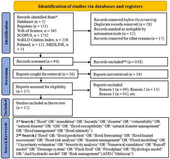
Figure 2.
Flowchart for the systematic literature review of flood applications in Malaysia ([21]) (the automation tool was not used for this systematic review because limited studies have been conducted, and those studies were easily identified, * denoted that the first observed articles and ** denoted that the article excluded from the similar article or non-English reason).
3. Natural Phenomenon
3.1. Natural Hazard
Natural hazards often occur in Malaysia throughout the year. Among these disasters are landslides, floods, earthquakes, tsunamis, etc. However, in general, these natural disasters are divided into three types of geological natural disasters, which are disasters involving the Earth’s surface, such as landslides, floods, and volcanic eruptions [22]. Next are meteorological natural disasters involving climate change, although some natural disasters occur in outer space, such as meteor showers and solar storms. Some geographic regions are more likely to experience particular natural hazards. These occurrences happen seasonally in some locations, such as the United States during the spring tornado season or the Atlantic, Caribbean, and Gulf of Mexico during the summer and autumn hurricane seasons. The most active tectonic plate boundaries are those between the Indo-Australian and Eurasian plates, where earthquakes and volcanic eruptions are most common [23].
Natural hazards can negatively impact the environment, human lives, and the nation’s economy, and individual natural disasters can cost tens of billions of USD in damages. These expenses could be related to the yearly damage to crops, structures, and infrastructure that happens in regions that are vulnerable to tropical cyclones or intense seasonal rainfall; for example, the floods in Pakistan in 2022 and Hurricane Katrina, which hit the southern United States in 2005, cost over USD 30 billion and USD 186 billion, respectively [24]. Similarly, earthquakes, which happen less frequently, can result in enormous expenses. For example, the 1989 Kobe earthquake in Japan and the 2008 Sichuan earthquake in China are estimated to have cost more than USD 100 billion and USD 86 billion, respectively [24].
Economic factors significantly impact people's lives, affecting opportunities and well-being. Although the number of fatalities from natural disasters also varies by region and event severity, the general trend indicates a decrease from the hundreds of thousands per year during the first half of the 20th century to about 45,000 deaths worldwide yearly (Table 1). Deaths also vary significantly from year to year, with astonishingly enormous calamities causing truly massive losses in life and minor natural dangers in places far from human habitation killing few. Among the most prominent catastrophic events in history were the 2004 Indian Ocean tsunami, which claimed over 225,000 lives; the 1976 Tangshan earthquake, which claimed over 242,000 lives; the 2010 Haitian earthquake, which some estimate may have claimed at least 300,000 lives; and the 1556 earthquake in China’s Shaanxi province, which claimed over 800,000 lives [24].
Each natural hazard provides a different use case for GIS applications. For example, authorities in Washington, DC, and the United States use the Hazus M-H flood model to manage natural disasters [25]. This model’s ability to predict the likelihood of damage caused by earthquakes, floods, hurricanes, and tsunamis is crucial. It is also meant to assist communities in gathering data about land use and other matters in places vulnerable to flooding. Landslides and floods are among the most frequent natural disasters in Malaysia because the effects of the construction of residential areas and non-structural buildings cause landfills, especially in the highlands. Thus, the proper use of GIS to predict and assess landslide conditions is through direct and indirect mapping [26]. According to the research [27], direct mapping necessitates geomorphologists’ expertise in assessing the terrain’s state and ascertaining possible trends directly. Statistical or deterministic models are used in indirect mapping to forecast probable landslide areas based on landslides [28].
Flood disasters considerably impact the human and economic aspects of a country. Apart from floods, landslides are also a frequent issue every year. Landslides can occur due to various human and environmental factors. Development structures, especially in highland areas, increase the risk of landslides. This increase is because the soil structure loosens and soil excavation increases during construction. Landslides become a problem when the disaster disrupts human activities, resulting in property damage and loss of life [29].

Table 1.
Impact on economic and non-economic losses.
Table 1.
Impact on economic and non-economic losses.
| Authors | Locations | Economic and Non-Economic Losses |
|---|---|---|
| [30] | Upper Awash River Basin, Ethiopia | Economic
|
| [31] | Ratnapura, Sri Lanka | Economic
|
| [32] | Central Indus River, Pakistan | Economic
|
| [33] | Japan | Economic
|
| [34] | Global | Economic
|
| [35] | Spain | Economic
|
Landslides can also influence flash floods. When a landslide occurs near a river or lake, the water level will rise and overflow to the surface. If this happens actively in a short time, flash floods can occur and cause nearby areas to be flooded, adversely affecting human activities and the environment. Surrounding residents living in low-lying regions risk facing flash floods due to overflowing water reservoirs [29]. For example, nearly all Mukim Kajang and most Mukim Cheras, which contain sizable built-up regions, have high-susceptibility areas. In the past, 48% of landslides have happened in these places [36]. Flash floods are also natural disasters that are often an issue for the community. Damage to property, residential areas, and pets, as well as disruptions to the lives of residents, are among the effects caused by flash floods. Some residents face the problem of disrupted lives in terms of living costs if they do not have sufficient savings to repair things destroyed due to a flood. Thus, the government must take action to ensure this problem will not remain in effect in the community.
3.2. Natural Hazard in Shah Alam and Klang, Selangor State
Flood management in Malaysia still has many weaknesses, although flood incidents have happened frequently over time. For example, in 2006, Shah Alam experienced severe flooding (https://www.water.gov.my/, accessed on 15 September 2024), and flood incidents were still present in Shah Alam in 2023. Flood management in Shah Alam is critical because the Shah Alam City Council is the first local authority among 155 local authorities in Malaysia to produce a voluntary local review (VLR) in response to Malaysia’s global commitment via the Intergovernmental Panel on Climate Change (IPCC).
One critical factor influencing flood disasters is prolonged rain because Malaysia, which is in the tropical climate region, generally experiences high rainfall levels. Land clearing activities and widespread and uncontrolled logging also contributed to an increase in the impact of flood disasters because water seepage into the ground is reduced, and water runoff directly into the river is quick. The development density of 3 between 0 and 40% increased the flow rate by 190%, and the speed doubled.
The most serious historical event in Malaysia is the flash flood that occurred on a large scale that surprised Malaysians in 2021. This event occurred due to prolonged heavy rain, damaging vehicles and houses in several areas around the Shah Alam Stadium, Sections 4, 9, and 10 [37]. The rainfall reached 380 mm, compared to the previous highest record of 180 mm [38]. In addition, heavy rain also resulted in the waterlogging in Shah Alam exceeding the appropriate limit until floods occurred. The unstructured drainage system also contributed to flooding [39]. The Royal Malaysian Police (PDRM) recorded a total of 48 deaths, while five people are still reported missing in the flood disaster that hit the country on 19 December 2021 [40]. Therefore, the level of safety and quality of life of the residents in the area are affected, resulting in agitated emotions, making it difficult for them to continue their daily activities.
The director of the Malaysian Fire and Rescue Department (JBPM) Selangor, Datuk Norazam Khamis, stated that such tragedies were expected to happen more frequently because of the torrential rains that often fall on the state as a result of global climate change. In addition, he said that the phenomenon of high tides that co-occur during heavy rains also contributes to flooding, especially in the Klang, Kuala Selangor, and Sabak Bernam Districts [39].
Figure 2 and Table 2 display the monthly average rainfall and temperature precipitation climate graph for Klang from 1961 to 2017. With 694 mm of precipitation each, November, April, and October were the three most precipitation-heavy months. November is the most precipitation-rich month, with an average rainfall of 257 mm. There is 2144 mm of precipitation in Klang annually. Rainfall amounts varied by 141 mm from November, when it peaked, to June, when it decreased. The average amount of rainfall rises toward the end of the year beginning in September, as can be roughly observed.
Table 2.
Rainfall and temperature averages each month in Klang, Malaysia, from 1961 to 2017 [41].
The northeast monsoon, which occurs at the end of the year, is the reason for this heavy rainfall since it brings much rain, particularly on Peninsular Malaysia’s east coast, which is east of Sabah and west of Sarawak [37]. The temperature differential between the land and the water, which results from warming caused by the sun’s rays, may cause this monsoon. The continental land region cools more quickly in the winter, resulting in extremely low temperatures in Central Asia (Figure 3). A high-pressure system is created due to the rise in atmospheric pressure. As a result of this phenomenon, chilly air will leave Siberia as a northwest wind and change to a northeast wind upon reaching China’s coastal waters before continuing to Southeast Asia [38].
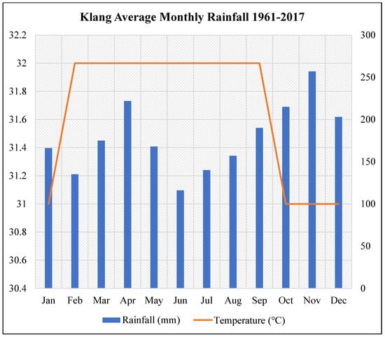
Figure 3.
Klang, Malaysia’s monthly average precipitation and temperature from 1961 to 2017 [41].
In Peninsular Malaysia’s western region, the Klang District lies near the sea. Therefore, high tides might also result in floods. Due to the tidal phenomenon, flooding was predicted on 23–26 December 2021, particularly in the Shah Alam and Klang Regions [39]. The Klang District Disaster Management Committee (JPBD) predicted that sea levels would rise to 5.1 m (Table 2). The Klang District has seen landslides and floods. Four persons were killed in a landslide that buried 14 bungalow houses in Taman Bukit Mewah and Taman Bukit Utama in the Bukit Antarabangsa neighbourhood of Hulu Klang in 2008. The area saw significant rain for a long time, which led to this occurrence. However, Shah Alam experienced a similar natural calamity to that which struck the Klang area.
3.3. Natural Hazard in the Kuala Lumpur Mega-Urban Region
Among the examples of flood disasters in Malaysia, the flooding incident in Kuala Lumpur in 1971 was severe. This disaster is one of the biggest tragedies in Malaysia’s history. In January 1971, heavy rains that continued for an extended period caused an increase in the accumulation of rainwater in the river. Then, the excess water in the river overflowed onto the land [42]. Almost 50% of Kuala Lumpur was submerged underwater. As many as 32 people were killed, and 180,000 were affected as a result of the flash flood. Starting in December 1970, the water levels in some rivers began to rise from 80 feet to 105 feet, or 24 m to 32 m from the normal level. During the floods of 1971, as many as 20 people died because of this massive flood until 5 January 1971, and the number of displaced residents amounted to 95,000 people. The floods that took a week to recede victimised as many as 24 people and involved property losses estimated to be worth more than RM 84.7 million [42].
3.4. Natural Hazard on the East Coast of Peninsular Malaysia
The states located on the east coast are Kelantan, Terengganu, and Pahang. These three states often experience flooding every year. On 19 December 2022, the flood victims in Terengganu, Kelantan, and Pahang continued to record an increase of 45,000 people [43]. As a result of this disaster, many residents in the region were affected socially and economically because their daily activities were impacted, resulting in the flood disaster that destroyed their residential areas, leading to huge losses (Table 3). For example, as many as 1250 fishermen across the country were affected by the floods that hit several states on the east coast. Most of them faced the destruction of their properties, houses, and fishing equipment, including boats [30]. Therefore, the government and community must unite to prevent this destruction from happening again.
Table 3.
Selangor flood details (Source: https://dewan.selangor.gov.my/hansard/1803/, accessed on 21 October 2024).
4. The Use of GIS Applications to Manage Floods in Malaysia
The government has taken various steps and actions to control and overcome the problem related to yearly flood disasters. The Department of Irrigation and Drainage (JPS) Malaysia took initial action to control these flood disasters by enhancing the drainage system in the Klang Valley [16]. Clogged gutters and the overall weakness of the drainage system are the leading causes of flash floods in several places in Kuala Lumpur and the Klang Valley. The weak drainage system inhibits river water from flowing freely because the community’s irresponsible attitude toward dumping waste into the river causes the waterway to clog. When heavy rains occur, the river water level exceeds the maximum, so the water overflows from the river to the land, and flooding occurs.
The government and researchers use GIS applications to track, analyse, and record natural disaster data that the government and researchers apply to flood risk management. A GIS uses the Earth as a guide to capture, store, analyse, integrate, manipulate, and display data about space [44]. Some government departments also use this GIS application to analyse natural disasters, temperature, and weather conditions to store data necessary for the country and its residents (Table 4). For example, the Department of Irrigation and Drainage (JPS) uses GIS applications to store water level, rainfall, temperature, and water rise data. Using this GIS application, the JPS can prepare for natural disaster management such as flash floods. Using this GIS application, the JPS can also provide disaster management plans using GIS data from various agencies that can be accessed through the web. The ability of this system aligns with JPS’s goals in disaster management.
Table 4.
Chronology of GIS implementation in Malaysia [45].
This study was conducted based on information analysis of 19 research articles accessed online. Papers that met the following criteria were retrieved from the Web of Science (WOS), SCOPUS, MDPI, Research Gate, and Google Scholar databases.
- Published between 2000 and 2022.
- Keywords used: GIS, flood risk mapping, natural hazard management, flood management, Malaysia.
- Focused on the gaps in using GIS in Malaysia and globally.
Natural disasters often occur in Malaysia, especially floods, because Malaysia is located at the equator, where it is hot and rainy every year (https://www.met.gov.my/en/pendidikan/fenomena-cuaca/, accessed on 25 September 2024). Malaysia has used various methods and studies to attempt to overcome the problems related to natural disasters. GIS has been used frequently recently, but this flood problem is worsening. Therefore, this study was conducted to explain to the government and the community the advantages and importance of using this GIS technology in natural disaster management. Producing this study can also make it easier for the community to understand the use of GIS and be more prepared in the face of natural disasters, especially floods (Table 5).
Table 5.
Flood incidents and the impact of using GIS.
Malaysia has used GIS since the 1960s. According to Table 4, among the offices and agencies that first used this GIS application was the Department of Survey and Mapping Malaysia (JUPEM), which carried out the transformation from analogue to digital by building the Digital Cadastral Database and National Topographic Database in mid-1980, followed by the Agriculture Department Agricultural Soil Source GIS Database in 1990. Flood-resilient infrastructure has seen large expenditures under the 12th Malaysia Plan (2021–2025), with GIS technologies helping to direct the installation of drainage systems, embankments, and retention ponds. To estimate possible outcomes and create mitigation strategies, the Department of Irrigation and Drainage (DID) uses GIS-based flood models. To identify flood hotspots, coordinate disaster response, and distribute relief resources as efficiently as possible, the National Disaster Management Agency (NADMA) also employs GIS. By integrating GIS for watershed management, the River Basin Management Plans (RBMP) improve flood control in areas susceptible to flooding.
4.1. Flood Susceptibility Mapping
Using anthropogenic, hydrological, and environmental factors, flood susceptibility mapping determines which locations are most likely to experience flooding. The use of GIS technologies is essential for superimposing spatial datasets such as slope, elevation, soil permeability, rainfall distribution, and river proximity. The methods for GIS-based flood susceptibility study include logistic regression, the Analytical Hierarchy Process (AHP), and machine learning algorithms (e.g., Random Forest, Decision Trees). These techniques create flood-prone maps by combining and weighing several parameters. According to research mapping flood susceptibility in Malaysia using GIS and AHP, areas in Pahang and Kelantan are especially vulnerable because of their inadequate drainage systems and high rainfall [51]. These maps are crucial for disaster risk reduction because they allow authorities to rank the locations that need mitigation measures, including buffer zones or improved drainage systems.
4.2. Flood Zone Identification
The goal of flood zone identification is to identify places that could be inundated under particular flood scenarios; these areas are usually classified as high-, moderate-, or low-risk zones. Flood zone maps are produced by the GIS by combining hydraulic modelling (such as flood wave propagation) with hydrological model outputs (such as river discharge). Rainfall data, river network data, and digital elevation models (DEMs) are used in this process. The Klang Valley has mapped flood extents during periods of heavy rainfall using a GIS-based flood zone identification method [52]. Urban planners have utilised these maps to steer clear of building infrastructure in high-risk locations. The design of levees and retention basins, as well as the distribution of emergency response resources and urban development planning, are all influenced by the designation of flood zones.
4.3. Urban Flood Risk Analysis
The impact of flooding in urban areas, where dense populations and vital infrastructure exacerbate the effects, is the main focus of urban flood risk assessments. To evaluate the susceptibility of metropolitan regions to floods, the GIS incorporates spatial data on land use, population density, transit networks, and building types. The risk of flash floods in Kuala Lumpur has been better understood thanks to GIS-based analysis, especially in places like Jalan Tun Razak, which frequently flood because of poor drainage and fast urbanisation [53]. Improved urban drainage systems, green infrastructure (like rain gardens), and sustainable land use policies are frequently emphasised in the research as ways to reduce the danger of urban flooding. Including data from the community (such as citizen reports of flooded regions) helps improve urban flood risk analysis based on GIS.
4.4. Post-Disaster Assessment
GIS is an effective tool for evaluating flood effects after the fact, supporting recovery planning, and revising risk estimations in the future. In post-disaster GIS analysis, impacted populations and infrastructure are identified, inundation extents are mapped, and economic damage is estimated. This is commonly performed using satellite photography (e.g., Sentinel-1 or Landsat). GIS was utilised to assess damage during the 2014 Kelantan floods, with an emphasis on displaced people and damaged infrastructure, to help guide recovery and disaster relief efforts [54]. Rebuilding initiatives benefit greatly from post-disaster assessments that use GIS to ensure that they are more robust to future occurrences.
By comparing pre- and post-disaster pictures, post-flood damage assessments mainly rely on GIS technology to determine damaged areas and calculate recovery costs. GIS maps are frequently utilised in community awareness initiatives to inform locals about flood readiness and evacuation routes. The integration of IoT and GIS for improved flood response capabilities is exemplified by initiatives like the Smart Selangor Flood Management System. The cooperation of government organisations, academic institutions, and private enterprises enhances Malaysia’s flood control tactics.
Future goals for Malaysia include developing community-based disaster risk reduction techniques, expanding data exchange among stakeholders, and improving its GIS infrastructure. It is still essential to execute GIS-based policies effectively to create a resilient and adaptable country that can handle the growing flooding risks. However, there are shortcomings and weaknesses in managing natural disasters, even though GIS applications are used. The failures in using GIS can be attributed to two constituent components: the comprehensive use of GIS and the level of government awareness of natural disasters. GIS is a technological application that requires significant skills and knowledge to master it. However, Malaysia only has a handful of experts or individuals who are GIS technology experts. GIS technology also has substantial costs when using the application. The government must import experts from outside the country to guide agencies in Malaysia in learning the science of this GIS field. Another method used is to send agency representatives from Malaysia who want to learn more about the field abroad so that their knowledge is more widespread. Because of the high costs associated with these activities, the government must make additional appropriations to accommodate the need to train experts or send agency representatives outside the country. Malaysia also lacks sophisticated IT technology compared to other countries. Tan Sri Alimuddin Mohd Dom, the Ministry of Education (KPM), was given an additional allocation in the 2023 budget to align with the countries’ desire to transform education (Table 6). Thus, the government is preparing to face this transformation to achieve its targets.
Table 6.
Relevant articles related to natural disasters in Malaysia.
4.5. Flood Plain Management
Floodplain management reduces flood damage while preserving ecological balance by controlling development and activities in flood-prone areas. By examining past floods, land use changes, and hydrological trends, GIS assists planners in modelling the dynamics of floodplains. In Malaysia, floodplain zoning laws that limit construction in high-risk regions and encourage the preservation of wetlands as natural flood buffers were created using GIS [62]. Cutting-edge GIS methods, like predictive floodplain modelling and IoT sensor integration, provide fresh approaches to efficiently monitor and manage floodplains. In Penang, the restoration of mangroves to serve as natural flood barriers has been guided by floodplain management aided by GIS.
GIS applications have various advantages in managing natural disasters in Malaysia and other countries. Several researchers have studied how to use GIS applications to manage natural disasters such as floods, land collapses, and earthquakes. GIS is a technology and application that benefits the government in various aspects. GIS allows agencies and governments to manage natural disasters before, during, and after the occurrence of natural disasters. Among the factors of GIS facilitating the management of natural disasters is that GIS applications can display information on the location of the disaster victim transfer centre. At the same time, the government can determine the locations of victims who need help by referring to the coordinated positions. GIS is a technology and mobile application using a laptop, making it easier to assess the expected natural disasters [63].
Flooding is a common disaster in Malaysia because weak natural disaster management causes flooding to occur frequently, especially in residential areas. Flooding also occurs due to natural factors such as prolonged rains that cause the water in rivers to exceed their capacity, overflow onto the land, and cover residential areas. The unstructured drainage system is also an issue in the occurrence of floods. So, the authorities must take action and steps to overcome this problem (Figure 4). Using GIS, the authorities efficiently receive information to save the flood victims. GIS has proven appropriate and effective in providing a proper and comprehensive analysis of flood-prone areas. This technology seeks to analyse and visualise a geographical area because identifying and understanding possible flood risk areas precisely is critical for reducing risks during disasters.
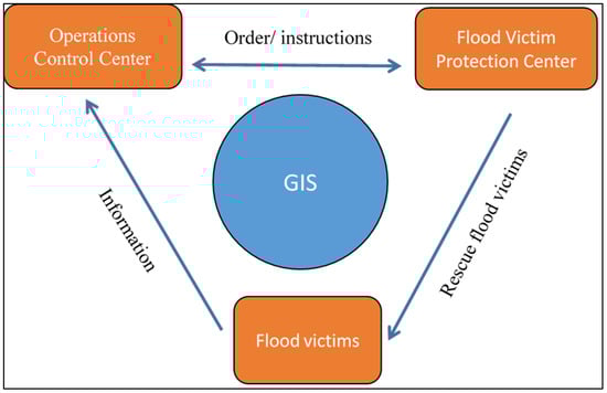
Figure 4.
Concept of flood management using a GIS application.
According to the research [56], flood regions were mapped in Pahang using GIS in 2012. A significant amount of the 2136 mm of annual rainfall in the Pahang River Basin is brought about by the northeast monsoon, which occurs between mid-October and mid-January [56]. Heavy rainfall when the monsoon passed through Pahang caused flooding. A terrain model was created for the study to map flooded areas. The digital elevation model (DEM) from the NASA Shuttle Radar Topography Mission (SRTM) characterised the terrain. This method made it possible to produce a map that showed the most frequent flood zones in Pahang. Using a GIS application, researchers employed various kernel functions to forecast flood events in the Terengganu state. The primary techniques employed in this study were GIS and remote sensing, which can facilitate overall flood management by generating quick data collection and analysis for hydrological studies.
The current flood mapping models have shortcomings that could be addressed with more complex and collaborative techniques [55]. The support vector machine (SVM) and frequency ratio (FR) methods can be integrated to provide spatial modelling for flood susceptibility evaluation. The findings of [52] demonstrated that the flood inventory map was randomly split into two datasets: 70% (115 flood sites) for training and 30% (40 flood locations) for validation. The spatial database included the curvature, geology, river, stream power index, rainfall, land use/cover, soil type, slope, topographic wetness index, and digital elevation models [55]. This method predicts flood events in the future, allowing the government and residents to be more prepared and take early action to deal with flood disasters.
Landslides are the second-largest disaster in Malaysia. Landslides occur due to the movement of masses such as sand, rock, and soil that move down the slope from upstream to downstream due to the pull of gravity. These landslides can occur, resulting in human activities such as hill area clearing, mining, development activities, and natural ones. Landslide movements can be classified as rock or debris fall, rock or debris slide, and debris or mudflow [64]. Each year, landslides cause billions of USD worth of damage and thousands of fatalities, making them one of the world’s most pervasive and severe hazards. This catastrophic event could endanger the local community’s safety because it will have numerous negative consequences for people. Severe rainfall frequently causes landslides in Malaysia, particularly during the summer monsoon, the northeast monsoon season (November to March), and the southwest monsoon season (end of May to September) [65]. According to [28], The GIS method will significantly impact the assessment of landslide disaster events. GIS can assess factors and map areas that could potentially experience land collapse in the future.
Two types of landslide mapping are conducted using the GIS approach: direct and indirect. According to [66], direct mapping necessitates geomorphologists’ expertise in evaluating the terrain’s condition and identifying possible trends directly. Based on landslide-related characteristics, indirect mapping makes predictions about possible landslide areas using statistical or deterministic algorithms. The Landslide Hazard Assessment Method (LHEF) is another technique employed in this study. It is a tool for mapping the study area’s possible landslide zones. Due to its clear weighting standards and ease of comprehension, this approach can aid in mitigating the highly subjective issue of accuracy when mapping possible collapse zones [28]. Using GIS can reduce the risk of hazards and predict areas with high potential for landslide disasters in Malaysia, allowing the government and residents to prepare early before a disaster.
5. Use of GIS Applications Globally for the Management of Floods
Governments in other countries use various methods of natural disaster management to overcome and control the effects of natural disasters that occur in their countries. Several studies conducted by foreign researchers are related to using GIS for natural disasters. For a flooding incident in Hurghada, Egypt, researchers used flood risk mapping to analyse and map the areas where flooding occurs or has the potential to occur [67]. Disaster risk management and the related decision-making processes are based on flood risk mapping. The approach used and the quality of the input data for the vulnerability and hazard maps significantly impact how effective this process is. Generally speaking, the usage of 2D models is advised for higher-quality hazard maps (Table 7). Other GIS techniques include remote sensing data and high-quality city strategy plans (CSPs). Hurghada, Egypt, which experienced numerous urban floods between 1996 and 2019, was the site of this process.
Table 7.
Relevant articles related to global natural disasters.
Aside from Egypt, the flood risk mapping approach is widely used across Europe to manage flood disasters in their nations. European flood mapping practices have been compiled by the Exchange Circle on Flood Mapping (EXCIMAP) [68]. The Atlas of Flood Maps and the Handbook on Good Practices for Flood Mapping in Europe, with examples from 19 European nations, Japan, and the USA, are the products of this inventory. Regarding the best methods to convey information about floods, this review emphasises the key findings of the EXCIMAP Handbook and Atlas [68]. With this flood risk assessment, researchers can forecast the areas where future flood events are likely.
Landslides are natural disasters that occur in hilly and mountainous areas. According to a study by Juan Remondo, these landslide events are very dangerous, and action must be taken to prevent these events from occurring [69]. Thus, a GIS application that monitors landslide events in Bajo Deba employed risk assessment and mapping methods based on recent incidents. The foundation for the approach was the previous susceptibility model created using statistical correlations between historical landslides and instability-related terrain factors.
Earthquakes are natural disasters that frequently happen in many nations, yet they occur infrequently in Malaysia, aside from land collapse events. By completing suitable statistical tests, the suggested GIS platform enables the ascertainment of the significance of the movement on GPS network tests conducted over time [75]. Barrile’s study indicates that even though this application uses one displacement component, using the three components will yield even more satisfying outcomes. Therefore, the combined use of GPS neural networks for earthquake prediction suggested in this application is a first step. Layers indicating slope, distance within flat areas, distance to buildings, and distance to road networks make up an evacuation resilience map, whereas levels reflecting geology, elevation, urban usage, and distance from shorelines show vulnerabilities in a location map [76].
6. Gaps in Using GIS Applications for Natural Hazard Management in Malaysia
Based on the current situation, the use of GIS related to natural hazards in Malaysia differs from other countries that are more advanced in technology and can handle GIS applications more carefully and meticulously. The ability of GIS to penetrate the education system in Malaysia is unclear. Various questions, such as the extent to which GIS is appropriate at the school level, its effectiveness for students, its compatibility with school students, and the ability of teachers to operate GIS, often arise [77]. GIS has also not yet been introduced in Malaysian schools for various reasons, such as the lack of ICT infrastructure facilities and human resources [78]. Most issues that often exist in implementing GIS are not successfully addressed in the plans that have been created. This issue is one reason that the use of GIS in Malaysia is still less widespread than in other countries.
Most organisations do not have enough staff to cope with the necessary work commitments, including excess work in introducing GIS as an existing operation in the organisation [76]. For instance, only a small number of government departments and agencies, including the National Disaster Management Agency (NADMA), the Department of Survey and Mapping Malaysia (JUPEM), the Department of Irrigation and Drainage (JPS), and agencies involved in the economy, use GIS applications to manage natural hazards in Malaysia. According to the latest information, Australia is one of the countries that uses GIS technology applications most effectively. If one looks at education from this point of view, it is very different from other countries. For example, 55 master’s courses in universities in Australia offer learning courses using GIS applications. Aided by this educational focus, the Australian government can produce highly skilled students and individuals in the field of GIS, which is not the case in Malaysia.
Since open-source software offers affordable and effective methods for monitoring, forecasting, and mitigation, it is essential to Malaysia’s flood control. While the River Analysis System (HEC-RAS) from the Hydrologic Engineering Center makes hydraulic modelling easier for floodplain management, the Quantum Geographic Information System (QGIS) allows for comprehensive flood mapping and spatial analysis. Watershed modelling and water resource planning are supported by the Soil and Water Assessment Tool (SWAT), while the Google Earth Engine (GEE) provides real-time remote sensing analysis for monitoring the amount of flooding. By using these methods, researchers and authorities may improve disaster preparedness, allocate resources more efficiently, and increase resilience to recurrent flood dangers.
Flood management strategies in Malaysia have significantly improved with cutting-edge technologies such as probabilistic frameworks, machine learning, deep learning, and remote sensing data. These methods improve preparedness and response to disasters by facilitating more accurate risk assessment, flood prediction, and real-time monitoring. Recent studies have demonstrated the efficacy of machine learning (ML) and deep learning (DL) models in estimating Malaysia’s flood risk. For instance, a geospatial strategy based on ensemble ML that integrated frequency ratio and support vector machine techniques was employed to create flood likelihood indices for the Damansara River Basin. This method used thirteen flood conditioning criteria, including land use/cover, height, and slope, to build a comprehensive flood hazard map.
Additionally, flood management has been addressed using deep learning techniques more often to overcome the drawbacks of conventional numerical models. According to an analysis of the literature, flood hazard mapping has benefited from convolutional neural networks (CNN) and long short-term memory (LSTM) models, which have demonstrated improved accuracy and speed compared to conventional methods. In Malaysia, flood control has entered a new era brought about by the convergence of machine learning, deep learning, probabilistic frameworks, and data from remote sensing. By enabling accurate flood forecasts, thorough risk analyses, and effective real-time monitoring, these cutting-edge approaches increase the country’s resistance to flood threats. The efficiency of flood management plans in Malaysia is being improved by ongoing research and development in these areas.
In addition, there are differences related to financial issues, such as Malaysia investing inadequate financial resources to acquire GIS methods that other countries use. Some studies used a statistical method. They created a structural equation model (SEM) to evaluate numerous socio-economic characteristics, including physical effects, mobility and life support system disruptions, health effects, and income-related effects [74]. For example, this evaluation includes the methodology used by the government in the United States to maintain and update models for calculating the threats of earthquake, flood, storm, and tsunami damage. Every Hazus model uses inventory data (on buildings, infrastructure, and population), data on the extent and severity of hazards, and damage functions unavailable in Malaysia because not all natural disasters, like earthquakes, occur there. As a result, the cost of obtaining the GIS application method is high (https://www.dhs.gov/, accessed on 28 October 2024).
Table 8.
Using GIS in hazard and disaster management.
Table 8.
Using GIS in hazard and disaster management.
| Reference | Location | Using GIS in Hazard and Disaster Management | |
|---|---|---|---|
| Pre-Disaster | Post-Disaster | ||
| [79] | Dhaka City, Bangladesh | Earthquake Risk Index | Designing a low-emission development strategy |
| Increase drainage capacity | Defining and shaping open learning around risk and resilience. | ||
| [49] | Poland | Using GIS and traffic engineering tools in flood emergency response to increase flood operation efficiency | Modern computer tools to analyse the effectiveness of the self-evacuation of the population by private vehicle transport |
| [80] | United State | Risk assessment and risk reduction by using E3R (Emergency Response and Risk Reduction) for a variety of hazards | Develop organisational and community capacity, including more visual details about selected assets such as schools, facilities where large numbers of people may assemble, and government buildings. |
| [81] | Brazil | Hydrological assessment to represent hazard by using arithmetic operators and weights for evaluating influences of significant factor | Floodplain mapping software by using MIKE FLOOD, HEC-GeoRAS, and RiverCAD |
| [82] | Malaysia | Flood risk assessment and remote sensing using GIS | Mapping flood areas and protected areas to improve flood management |
| [83] | Philippines | Flood risk assessment and analysis using AHP for evaluating risk | Improve research and application in education |
| [84] | Sindh Province, Pakistan | Flood hazard mapping and flood shelter suitability analysis | Analytic hierarchy process (AHP) techniques to further identify the severity of future flood risk |
| [50] | Africa | Mapping floodplains and flood disaster risks by presenting the physical extent of the risk | Used statistical methods to model changes in the peak flow of water |
| [85] | Fukushima, Japan | Radiation measurements in the Fukushima area were mapped using ArcGIS | Used flood risk mapping to track the location of shelters and the number of evacuees |
| [86] | Queensland, Australia | Disaster risk management by communicating infrastructures and evaluating disaster plans | Measures land use planning to interact with the spatial dimension of a disaster. |
Meanwhile, in Phuket, Thailand, researchers employed a dissymmetric mapping strategy that combined remote sensing data with a population-weighted algorithm [72]. The mapping’s outcomes display the coordinates of each evacuee shelter together with the lowest and greatest number of tsunami victims (Table 8). AdaTepe in Bulgaria is another example of a company that uses GIS techniques to combine fundamental geo-datasets with thematic mapping products to evaluate seismic hazards and provide a foundation for disaster management [87].
Malaysia also uses a tool for integrated flood management, the Environmentally Friendly Drainage Manual (MSMA), to create guidance for all parties, especially the government, in flood management planning. A GIS program called ArcGIS 10.8.2 was used to perform several spatial analyses, in which maps representing each physical factor were layered with the distribution of landslide events [88]. Thus, with this tool, the flood management system in Malaysia will be more organised. Another example is in Sarawak, where residents also need knowledge of flood causes, processes, and effects to reduce the risk of flooding [89].
Funding the costs of learning GIS is expensive, especially when Malaysian students or workers want to study GIS abroad to acquire the necessary skills. Moreover, if GIS experts are imported from abroad, high costs are incurred for the experts to teach GIS in Malaysia [9]. Therefore, to make progress in the technology sector of GIS, Malaysia must be ready and willing to take risks. Using GIS in managing natural disasters must be more structured regarding users’ skills and knowledge to help them handle this GIS application as skillfully as those in other countries. The government does not apply knowledge of GIS in early school education so that students can gain this knowledge earlier to make the field of GIS essential [90]. This deficiency exists because experienced GIS technology management, particularly natural catastrophe management, is problematic due to the Malaysian state’s shortage of GIS professionals. In the US, GIS education is at a turning point [42].
Research findings indicate that the Teiji Watershed’s flood hazard map was appropriately classified into five categories: extremely low, low, moderate, high, and very high flood susceptibility (Figure 5). Extremely low to low flood danger zones were identified by their steep slope, higher elevation, and low drainage density. These zones were mainly found along the watershed’s upstream portion (Figure 6). The floods in Peninsular Malaysia were heavily considered in 1965, 1967, 1971, 1973, 1983, 1988, 1993, 1998, 2000, 2007, 2008, 2009, 2010, and 2014. The map was produced by estimating the flooding areas during past floods using satellite imagery and ground observation data (Figure 7). The outcome suggests that coastal plains are where floods generally happen. Flood susceptibility is lower in the peninsula’s centre since these areas are less likely to experience floods. In contrast, the flood risk is higher in the south, particularly in the southeast and southwest coastal areas.
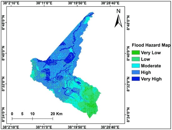
Figure 5.
Flood hazard map at the Teji Watershed [30].
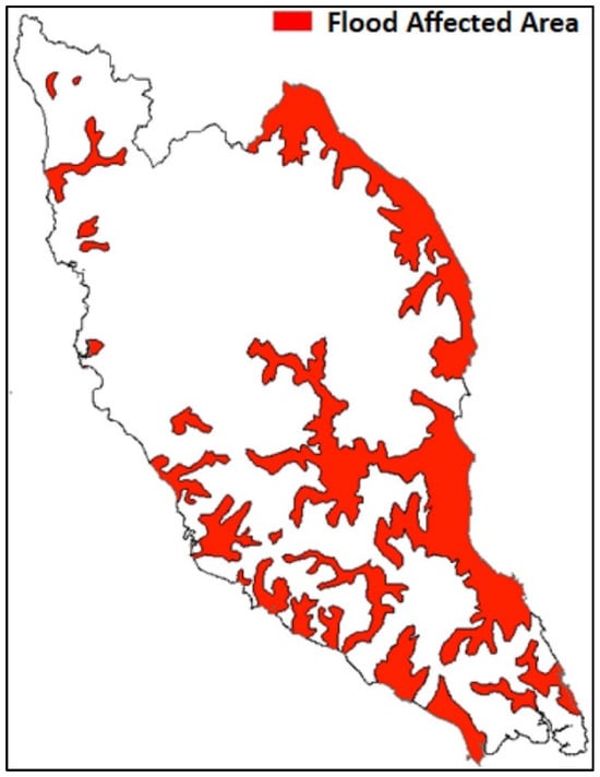
Figure 6.
Flood-affected areas in Malaysia [91].
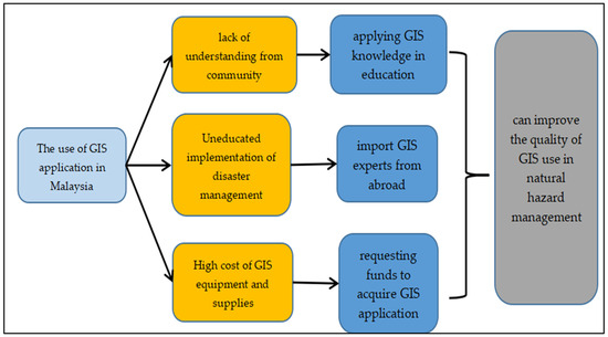
Figure 7.
Proposed use of GIS application in Malaysia.
Many solutions have been proposed to address these problems. By utilising GIS data in the classroom, teachers can increase awareness and create a workforce equipped to understand the importance and functionality of the technology. Another tactic to close the current knowledge gap is to bring in foreign GIS specialists to train local professionals. Furthermore, organisations can successfully include GIS in their disaster management procedures by requesting funding to purchase GIS programs, which can lower costs and increase accessibility to cutting-edge technologies. By putting these suggestions into practice, Malaysia can improve the standard of GIS application in managing natural hazards. Better knowledge, more skilled personnel, and access to cutting-edge equipment will result in more successful preparedness, response, and recovery activities. By taking these actions, it will be possible to guarantee that GIS plays a crucial role in controlling natural catastrophes, thereby lessening their effects and boosting community resilience. To achieve long-term success in using GIS for disaster management, cooperation across the public, corporate, and community sectors is necessary to overcome these obstacles.
The results in this context closely match and support important ideas put forth in previous review and survey research on GIS-based flood management in Malaysia. High-quality, thorough data are essential for improving GIS-based flood risk assessment and management, according to previous research. Researchers contend that flood risk models and early warning systems are much more accurate when GIS is integrated with topography information, land use changes, and historical flood records. The immediate effects of data shortages on infrastructure development, urban planning, and predictive modelling are highlighted in the current discussion to emphasise these concerns. This study also supports the notion that a GIS’s utility is founded on the reliability and granularity of its data sources.
The resulting findings confirm these well-established concepts and support demands for multi-sectoral cooperation to fill data gaps, including collaborations for data exchange and technical assistance among government agencies, academic institutions, and international organisations. The idea that using cutting-edge technology like AI and remote sensing, in addition to conventional data collection techniques, can help overcome the difficulties brought on by the constraints of historical data is supported by these findings. Collectively, these findings support the significance of a data-centric strategy in GIS-based flood control systems and point to areas for further development in line with suggestions in the previous research.
7. GIS Implementation Cost in Malaysia
It can be expensive to use GIS technology for flood control in Malaysia, especially given the country’s finances, which frequently prevent the widespread adoption of new technologies. The expenses of using GIS technology for flood control in Malaysia are examined in this research, with a focus on software, hardware, data collecting, human resources, and maintenance [16].
GIS technology is a vital tool for flood management since it enables real-time monitoring, risk assessment, and sophisticated spatial analysis. In Malaysia, the Department of Irrigation and Drainage (DID) and other government organisations make extensive use of Esri’s ArcGIS [92]. Typically, ArcGIS software licenses cost between MYR 7000 and MYR 15,000 per person per year. Enterprise server solutions might cost anything from MYR 40,000 to MYR 200,000 annually. Cost-effective options include platforms such as GRASS GIS and QGIS [93]. The program itself is free, but for a medium-sized project, initial customisation and integration with current systems could cost MYR 50,000 to MYR 100,000. The cost of hydrological modelling programs, like HEC-RAS or Mike Flood, which are frequently connected with GIS, ranges from MYR 5000 to MYR 50,000, depending on the features and licenses needed (https://publicinfobanjir.water.gov.my/mengenai-kami/prabn/?lang=en, accessed on 27 December 2024).
The cost of high-performance workstations required for GIS processing ranges from MYR 10,000 to MYR 25,000 per unit. Server prices for centralised data management vary from MYR 50,000 to MYR 200,000, contingent on redundancy and capacity needs. The use of cloud storage services (like AWS or Microsoft Azure) is growing as big data become more and more important. Cloud storage costs between MYR 500 and MYR 2000 per terabyte per year, whilst on-premise storage solutions might cost between MYR 50,000 and MYR 150,000 all at once (https://esrimalaysia.com.my/, assessed on 27 December 2024).
While high-resolution commercial satellite photography, such WorldView, costs between MYR 50 and MYR 150 per km2, free imagery from Sentinel and Landsat can satisfy some demands. LiDAR data, which are used to generate comprehensive flood models, cost between MYR 1000 and MYR 2500 per km² in Malaysia [62]. Projects involving field validation and local data collecting usually cost between MYR 10,000 and MYR 50,000, depending on the complexity and research location.
Hiring GIS specialists is essential. While seasoned GIS managers can command MYR 8000 to MYR 15,000 per month, GIS analysts in Malaysia typically earn between MYR 3000 and MYR 7000. The cost of capacity building for government and non-governmental employees can range from MYR 5000 to MYR 20,000 for each training session, contingent on the length and complexity of the course [94]. The average cost of yearly maintenance for GIS hardware and software is between 10% and 20% of the original expenditure. The annual budget for a medium-sized project may be between MYR 50,000 and MYR 200,000. The annual cost of updating spatial datasets, including flood risk maps, can range from MYR 20,000 to MYR 100,000. The annual cost of third-party technical help might range from MYR 30,000 to MYR 100,000, contingent on the amount of service needed.
Programs like the National Flood Forecasting and Warning System (NaFFWS), which reportedly cost about MYR 500 million and include GIS components, data collecting, and system integration, are examples of how the Malaysian government has invested in GIS for flood management [95]. To maximise their finances, non-governmental organisations like the Malaysian Red Crescent Society employ open-source GIS software. For example, using volunteer skills and open-source tools, an NGO’s flood mapping effort in Kelantan cost about MYR 100,000 [96].
For medium-sized projects, the cost of using GIS technology for flood management in Malaysia might range from MYR 500,000 to MYR 5 million, depending on the system’s complexity and size [97]. Improved flood risk management can have substantial expenditures, but the advantages, such as lower damage costs and increased preparedness for emergencies, often surpass the initial outlays. Financial obstacles can be reduced by governmental and non-governmental organisations working together and by strategically utilising open-source technologies.
8. Lack of Data Availability in Malaysia
Insufficient historical data on land use, topography, and floods has a major effect on how well GIS applications work in Malaysia. Reliable flood risk maps and early warning systems cannot be developed because it is difficult to identify flood-prone locations or accurately predict flood patterns due to a lack of historical flood records. The calibration and validation of hydrological and hydraulic models depend heavily on historical data; the lack of these data can lower prediction accuracy and affect attempts to prepare for and mitigate disasters.
The lack of comprehensive and historical land use data makes it more difficult to comprehend how urbanisation affects natural resources and flood risks in land use planning. This may result in development choices that are ill-informed and worsen environmental deterioration and flooding. Historical data are also essential to identify changes over time, like urbanisation or deforestation, that impact flood dynamics and ecosystem health.
Incomplete or low-resolution data make it difficult to create reliable digital elevation models (DEMs) for estimating flood extents, drainage patterns, and water flow in topographic study. This restriction has an impact on the design and building of drainage systems and levees, two examples of flood control infrastructure. Also, the lack of historical topographic data makes it more difficult to track long-term climate and environmental trends, making it harder to link human activity to changes in land degradation and flood patterns. The lack of these insights makes it difficult for planners and policymakers to assess the success of previous actions and to create well-informed plans.
Since visualisations and tools intended to enlighten communities about hazards and mitigation strategies rely significantly on historical data, the absence of such data also affects public awareness and engagement. To overcome these obstacles, funds must be allocated for data gathering, digitisation, and the deployment of cutting-edge technology such as artificial intelligence and remote sensing to close data gaps. Environmental sustainability, urban planning, and disaster management can all be improved in Malaysia by increasing data availability for GIS applications.
9. Conclusions and Recommendations
Natural hazards are risks and events that cannot be avoided because they occur naturally. Natural disasters will hurt humans and the environment. In general, natural disasters can destroy and damage all objects on Earth, such as the destruction of residential areas and the destruction of the environment. Therefore, government experts and researchers have taken action to deal with these issues instead of allowing them to directly affect human life. Educators have conducted various studies to analyse and compile important information related to natural disasters to provide the government and residents with a deeper understanding. These studies can guide the government to be more controlled in managing natural disasters, especially flood disasters in Malaysia. GIS is one of the systems and applications used by agencies and governments to analyse and map potential areas to predict natural disasters in the future. GIS can help many expert commentators conduct their research when used in natural disaster management. In addition, the use of GIS in managing natural disasters can improve the quality of management and significantly impact the country and the population by improving the quality of life and offering a more organised method of dealing with natural disasters in the future. In addition, by making disaster risk mapping easy, knowledge can be increased so that the people and the general public can understand natural disaster mapping provided by researchers and the government. Some recommendations to reduce the flood impact in Malaysia are as follows:
- Establish a Centralized GIS Database: Government organisations and urban planners should work together to establish and manage a centralised database that combines topographic, land use, and flood history information.
- Use AI and Remote Sensing: AI algorithms can be used to improve flood modelling’s prediction power, while remote sensing technology can be used to augment historical data gaps.
- Utilize Community-Generated Data: Promote citizen science projects to gather local flood data, as this can enhance GIS applications and increase data accuracy.
- Encourage Interagency Collaboration: To guarantee data exchange, technical know-how, and financing for GIS-related projects, cultivate alliances among regional administrations, federal agencies, and international organisations.
- GIS should be integrated with other planning tools by urban planners in order to create land use plans and zoning laws that reduce the danger of flooding and encourage resilient development.
Therefore, the government should advance the use of GIS, especially in managing natural hazards, by adding the subject to early school education so that students can gain knowledge earlier to make GIS one of the country’s essential fields. This is because the lack of GIS experts in Malaysia now is a problem for tools that use GIS technology, especially those used in natural disaster management. In addition, by importing GIS scientists and experts from abroad, the country can expand its knowledge of GIS because experts from abroad have more in-depth knowledge about using GIS technology. The presence of GIS professionals can help achieve better and broader use of GIS, particularly in managing natural disasters, to mitigate the factors exacerbating disaster situations and the consequences arising from natural disasters. A more organised and structured approach can enhance the nation’s natural catastrophe management.
Author Contributions
Conceptualization, A.N.L., M.F.A., M.B.M., and B.H.; methodology, A.N.L., M.F.A., M.B.M., and B.H.; software, A.N.L., M.F.A., and B.H.; validation, A.N.L., M.F.A., B.H., and M.S.; formal analysis, M.F.A., M.B.M., B.H., C.K.L., N.A.M., and M.S.; investigation, A.N.L., M.F.A., M.S., and B.H.; resources, M.F.A., and B.H.; data curation, A.N.L., M.F.A., M.B.M., B.H., C.K.L., and N.A.M.; writing—original draft preparation, A.N.L., M.F.A., M.B.M., B.H., C.K.L., N.A.M., and M.S.; writing—review and editing, A.N.L., M.F.A., M.B.M., B.H., C.K.L., N.A.M., and M.S.; visualisation, M.F.A., B.H., and M.S.; supervision, M.F.A.; project administration, M.F.A., B.H., and M.S.; funding acquisition, M.S. All authors have read and agreed to the published version of the manuscript.
Funding
This study is supported by the Ministry of Higher Education (MOHE) Malaysia, Fundamental Research Grant Scheme (FRGS)–FRGS/1/2022/SSI03/UKM/03/1.
Data Availability Statement
Not applicable.
Conflicts of Interest
Author Miklas Scholz was employed by the companies Kunststoff-Technik Adams and Nexus by Sweden. The remaining authors declare that the research was conducted in the absence of any commercial or financial relationships that could be construed as a potential conflict of interest.
References
- Coburn, A.W.; Spence, R.J.S.; Pomonis, A. Factors Determining Human Casualty Levels in Earthquakes: Mortality Prediction in Building Collapse. In Proceedings of the Tenth World Conference on Earthquake Engineering, Madrid, Spain, 19–24 July 1992; Volume 10, pp. 5989–5994. [Google Scholar]
- Prasad, A.S.; Francescutti, L.H. Natural Disasters. In International Encyclopedia of Public Health; Elsevier: Amsterdam, The Netherlands, 2016; p. 215. [Google Scholar]
- Ahmed, M.F. Climate Change Adaptation and Mitigation Measures at Local and National Levels for Sustainable Development. Int. J. Clim. Change Strateg. Manag. 2023, 15, 577–578. [Google Scholar] [CrossRef]
- Hidalgo, J.; Baez, A.A. Natural disasters. Crit. Care Clin. 2019, 35, 591–607. [Google Scholar] [CrossRef] [PubMed]
- Ha, H.; Bui, Q.D.; Nguyen, H.D.; Pham, B.T.; Lai, T.D.; Luu, C. A Practical Approach to Flood Hazard, Vulnerability, and Risk Assessing and Mapping for Quang Binh Province, Vietnam. Environ. Dev. Sustain. 2023, 25, 1101–1130. [Google Scholar] [CrossRef]
- Mokhtar, M.; Ahmed, M.F.; Lee, K.E.; Alam, L.; Goh, C.T.; Elfithri, R.; Tajam, J.; Wong, A.K.H. Achieving Sustainable Coastal Environment in Langkawi, Malaysia. Borneo J. Mar. Sci. Aquac. 2017, 1, 7–15. [Google Scholar] [CrossRef]
- Safiah Yusmah, M.Y.; Bracken, L.J.; Sahdan, Z.; Norhaslina, H.; Melasutra, M.D.; Ghaffarianhoseini, A.; Sumiliana, S.; Shereen Farisha, A.S. Understanding Urban Flood Vulnerability and Resilience: A Case Study of Kuantan, Pahang, Malaysia. Nat. Hazards 2020, 101, 551–571. [Google Scholar] [CrossRef]
- Ahmed, M.F.; Alam, L.; Ta, G.C.; Mohamed, C.A.R.; Mokhtar, M. A Review on the Environmental Pollution of Langat River, Malaysia. Asian J. Water Environ. Pollut. 2016, 13, 25–31. [Google Scholar] [CrossRef]
- Zulkafli, S.A.; Abd Majid, N.; Rainis, R. Spatial Analysis on the Variances of Landslide Factors Using Geographically Weighted Logistic Regression in Penang Island, Malaysia. Sustainability 2023, 15, 852. [Google Scholar] [CrossRef]
- Hakim, H.M.; Selamat, S.N.; Majid, N.A.; Rasudin, N.S.; Rahman, M.A.; Ismail, S.A.; Edinur, H.A. Landslide at Father’s Organic Farm: DVI and the Health Indicators During Monsoons. Malays. J. Med. Health Sci. 2023, 19, 250–254. [Google Scholar]
- Marengo, J.A.; Alcantara, E.; Cunha, A.P.; Seluchi, M.; Nobre, C.A.; Dolif, G.; Goncalves, D.; Dias, M.A.; Cuartas, L.A.; Bender, F.; et al. Flash floods and landslides in the city of Recife, Northeast Brazil after heavy rain on May 25–28, 2022: Causes, impacts, and disaster preparedness. Weather. Clim. Extrem. 2023, 39, 100545. [Google Scholar] [CrossRef]
- UN Department of Economic and Social Affairs. Flood Management and Climate Change Adaptation in Malaysia; UN Department of Economic and Social Affairs: New York, NY, USA, 2023. [Google Scholar]
- Muzamil, S.A.H.B.S.; Zainun, N.Y.; Ajman, N.N.; Sulaiman, N.; Khahro, S.H.; Rohani, M.M.; Mohd, S.M.B.; Ahmad, H. Proposed Framework for the Flood Disaster Management Cycle in Malaysia. Sustainability 2022, 14, 4088. [Google Scholar] [CrossRef]
- Farid Ahmed, M.; Mokhtar, M.B.; Lim, C.K.; Suza, I.A.B.C.; Ayob, K.A.K.; Khirotdin, R.P.K.; Majid, N.A. Integrated River Basin Management for Sustainable Development: Time for Stronger Action. Water 2023, 15, 2497. [Google Scholar] [CrossRef]
- Ahmed, M.F.; Mokhtar, M.B.; Alam, L. Factors Influencing People’s Willingness to Participate in Sustainable Water Resources Management in Malaysia. J. Hydrol. Reg. Stud. 2020, 31, 100737. [Google Scholar] [CrossRef]
- Department of Irrigation and Drainage. Managing the Flood Problem in Malaysia; Department of Irrigation and Drainage: Cyberjaya, Malaysia, 2020.
- Coppola, D.P. Hazards. In Introduction to International Disaster Management; Elsevier: Amsterdam, The Netherlands, 2015; p. 40. [Google Scholar]
- Hwang, M.Y. Flood Preparedness, Response and Recovery of Flood Affected Business Owners in Shah Alam in 2021. 2022. Available online: http://eprints.utar.edu.my/5837/ (accessed on 4 December 2024).
- Gao, G.; San, L.H.; Zhu, Y. Flood Inundation Analysis in Penang Island (Malaysia) Based on InSAR Maps of Land Subsidence and Local Sea Level Scenarios. Water 2021, 13, 1518. [Google Scholar] [CrossRef]
- Zainuddin, M.Z. Banjir: Perlu Cepat Bertindak Elak Kesan Ekonomi. Berita Harian, 20 December 2021. Available online: https://www.bharian.com.my/bisnes/lain-lain/2021/12/901553/banjir-perlu-cepat-bertindak-elak-kesan-ekonomi (accessed on 4 December 2024).
- Page, M.J.; McKenzie, J.E.; Bossuyt, P.M.; Boutron, I.; Hoffmann, T.C.; Mulrow, C.D.; Shamseer, L.; Tetzlaff, J.M.; Akl, E.A.; Brennan, S.E. The PRISMA 2020 Statement: An Updated Guideline for Reporting Systematic Reviews. BMJ 2021, 372, n71. [Google Scholar] [CrossRef] [PubMed]
- Mudashiru, R.B.; Sabtu, N.; Abdullah, R.; Saleh, A.; Abustan, I. A Comparison of Three Multi-Criteria Decision-Making Models in Mapping Flood Hazard Areas of Northeast Penang, Malaysia. Nat. Hazards 2022, 112, 1903–1939. [Google Scholar] [CrossRef]
- Metych, M. Natural Disaster; Encyclopedia Britannica: Edinburgh, UK, 2023. [Google Scholar]
- Harrison, C.G.; Williams, P.R. A Systems Approach to Natural Disaster Resilience. Simul. Model. Pract. Theory 2016, 65, 11–31. [Google Scholar] [CrossRef]
- Federal Emergency Management Agency Mitigation Division. Multi-Hazard Loss Estimation Methodology; Federal Emergency Management Agency Mitigation Division: Hyattsville, MD, USA, 2005.
- Hua, A.K. Sistem Informasi Geografi (GIS): Pengenalan Kepada Perspektif Komputer. Geogr. J. Soc. Space 2015, 11, 24–31. [Google Scholar]
- Van Westen, C.J.; Castellanos, E.; Kuriakose, S.L. Spatial Data for Landslide Susceptibility, Hazard, and Vulnerability Assessment: An Overview. Eng. Geol. 2008, 102, 112–131. [Google Scholar] [CrossRef]
- Simon, N.; Akhir, J.M.; Napiah, A.; Kee, T.H. Pemetaan Potensi Bencana Tanah Runtuh Menggunakan Faktor Penilaian Bencana Tanah Runtuh Dengan Pendekatan GIS (IN MALAY), Landslide Hazard Potential Mapping Using Landslide Hazard Evaluation Factor with GIS Approach. Bull. Geol. Soc. Malays. 2009, 55, 47–53. [Google Scholar] [CrossRef]
- Nor Diana, M.I.; Muhamad, N.; Taha, M.R.; Osman, A.; Alam, M.M. Social Vulnerability Assessment for Landslide Hazards in Malaysia: A Systematic Review Study. Land 2021, 10, 315. [Google Scholar] [CrossRef]
- Hagos, Y.G.; Andualem, T.G.; Yibeltal, M.; Mengie, M.A. Flood Hazard Assessment and Mapping Using GIS Integrated with Multi-Criteria Decision Analysis in Upper Awash River Basin, Ethiopia. Appl. Water Sci. 2022, 12, 148. [Google Scholar] [CrossRef]
- De Silva, M.; Kawasaki, A. Modeling the Association between Socioeconomic Features and Risk of Flood Damage: A Local-scale Case Study in Sri Lanka. Risk Anal. 2022, 42, 2735–2747. [Google Scholar] [CrossRef] [PubMed]
- Ashraf, I.; Ahmad, S.R.; Ashraf, U.; Khan, M. Community Perspectives to Improve Flood Management and Socio-Economic Impacts of Floods at Central Indus River, Pakistan. Int. J. Disaster Risk Reduct. 2023, 92, 103718. [Google Scholar] [CrossRef]
- Tezuka, S.; Takiguchi, H.; Kazama, S.; Sato, A.; Kawagoe, S.; Sarukkalige, R. Estimation of the Effects of Climate Change on Flood-Triggered Economic Losses in Japan. Int. J. Disaster Risk Reduct. 2014, 9, 58–67. [Google Scholar] [CrossRef]
- Hamidifar, H.; Nones, M. Spatiotemporal Variations of Riverine Flood Fatalities: 70 Years Global to Regional Perspective. River 2023, 2, 222–238. [Google Scholar] [CrossRef]
- González, P.A.; Ruiz, N.S.; Delgado, R.C.; Martínez, J.A.C. Disasters in Spain from 1950–2020: Impact on Public Health. Prehosp. Disaster Med. 2023, 38, 264–269. [Google Scholar] [CrossRef]
- Sim, K.B.; Lee, M.L.; Wong, S.Y. A Review of Landslide Acceptable Risk and Tolerable Risk. Geoenvironmental Disasters 2022, 9, 3. [Google Scholar] [CrossRef]
- Available online: https://www.malaysianow.com/my/news/2021/12/28/di-sebalik-banjir-kerap-di-shah-alam (accessed on 21 November 2024).
- Available online: https://www.astroawani.com/berita-malaysia/banjir-di-selangor-taburan-hujan-luar-biasa-jumlah-mangsa-dijangka-cecah-5000-mb-337067 (accessed on 20 November 2024).
- Available online: https://www.ummahtoday.com.my/kerap-hujan-lebat-longkang-tersumbat-punca-banjir-di-selangor/ (accessed on 20 November 2024).
- Available online: https://www.bharian.com.my/berita/nasional/2021/12/904586/banjir-48-kematian-5-masih-hilang-pdrm (accessed on 20 November 2024).
- HikersBay Climate Conditions in Klang. 2018. Available online: https://hikersbay.com/climate-conditions/malaysia/klang/climate-conditions-in-klang.html?lang=en#google_vignette (accessed on 15 November 2024).
- Sauti, N.S.; Daud, M.E.; Kaamin, M.; Remali, N. Teknologi Georuang Dalam Analisis Potensi Dan Pemetaan Risiko Tsunami Di Pantai Barat Semenanjung Malaysia. Sains Malays. 2021, 50, 929–943. [Google Scholar] [CrossRef]
- The Star Floods: Pahang Latest State to Be Hit, More Evacuees Recorded in Terengganu, Kelantan. 2022. Available online: https://hikersbay.com/climate-conditions/malaysia/klang/climate-conditions-in-klang.html?lang=en#google_vignette (accessed on 15 November 2024).
- Aydin, H.E.; Iban, M.C. Predicting and Analyzing Flood Susceptibility Using Boosting-Based Ensemble Machine Learning Algorithms with SHapley Additive ExPlanations. Nat. Hazards 2023, 116, 2957–2991. [Google Scholar] [CrossRef]
- Pettinger, L.; Forkert, K.; Goffey, A. The Promises of Creative Industry Higher Education: An Analysis of University Prospectuses in Malaysia. Int. J. Cult. Policy 2018, 24, 466–484. [Google Scholar] [CrossRef]
- Chau, V.N.; Holland, J.; Cassells, S.; Tuohy, M. Using GIS to Map Impacts upon Agriculture from Extreme Floods in Vietnam. Appl. Geogr. 2013, 41, 65–74. [Google Scholar] [CrossRef]
- Lin, L.; Tang, C.; Liang, Q.; Wu, Z.; Wang, X.; Zhao, S. Rapid Urban Flood Risk Mapping for Data-Scarce Environments Using Social Sensing and Region-Stable Deep Neural Network. J. Hydrol. 2023, 617, 128758. [Google Scholar] [CrossRef]
- Ziwei, L.; Xiangling, T.; Liju, L.; Yanqi, C.; Xingming, W.; Dishan, Y. GIS-Based Risk Assessment of Flood Disaster in the Lijiang River Basin. Sci. Rep. 2023, 13, 6160. [Google Scholar] [CrossRef] [PubMed]
- Borowska-Stefańska, M.; Balážovičová, L.; Goniewicz, K.; Kowalski, M.; Kurzyk, P.; Masný, M.; Wiśniewski, S.; Žoncová, M.; Khorram-Manesh, A. Emergency Management of Self-Evacuation from Flood Hazard Areas in Poland. Transp. Res. Part D Transp. Environ. 2022, 107, 103307. [Google Scholar] [CrossRef]
- Ntajal, J.; Lamptey, B.L.; Mahamadou, I.B.; Nyarko, B.K. Flood Disaster Risk Mapping in the Lower Mono River Basin in Togo, West Africa. Int. J. Disaster Risk Reduct. 2017, 23, 93–103. [Google Scholar] [CrossRef]
- Bagheri, M.; Zaiton Ibrahim, Z.; Mansor, S.; Manaf, L.A.; Akhir, M.F.; Talaat, W.I.A.W.; Beiranvand Pour, A. Land-Use Suitability Assessment Using Delphi and Analytical Hierarchy Process (D-AHP) Hybrid Model for Coastal City Management: Kuala Terengganu, Peninsular Malaysia. ISPRS Int. J. Geo-Inf. 2021, 10, 621. [Google Scholar] [CrossRef]
- Mohameda, M.A.; Zamana, A.Q.M.; Kajewskib, S.; Trigunarsyahc, B. Enhancing Flood Disaster Management in Klang Valley. J. Kejuruter. 2024, 36, 2709–2715. [Google Scholar] [CrossRef]
- Bhuiyan, T.R.; Er, A.C.; Muhamad, N.; Pereira, J.J. Evaluating the Cumulative Costs of Small-Scale Flash Floods in Kuala Lumpur, Malaysia. J. Hydrol. 2022, 612, 128181. [Google Scholar] [CrossRef]
- Radi, M.F.M.; Hashim, J.H.; Jaafar, M.H.; Hod, R.; Ahmad, N.; Nawi, A.M.; Baloch, G.M.; Ismail, R.; Ayub, N.I.F. Lessons on Environmental Health and Disaster Preparedness, Response and Recovery from the Severe Kelantan Flooding in 2014. Int. J. Emerg. Manag. 2019, 15, 26–53. [Google Scholar] [CrossRef]
- Tehrany, M.S.; Pradhan, B.; Jebur, M.N. Flood Susceptibility Analysis and Its Verification Using a Novel Ensemble Support Vector Machine and Frequency Ratio Method. Stoch. Environ. Res. Risk Assess. 2015, 29, 1149–1165. [Google Scholar] [CrossRef]
- Ghani, A.A.; Chang, C.K.; Leow, C.S.; Zakaria, N.A. Sungai Pahang Digital Flood Mapping: 2007 Flood. Int. J. River Basin Manag. 2012, 10, 139–148. [Google Scholar] [CrossRef]
- Merz, B.; Thieken, A.H.; Gocht, M. Flood Risk Mapping At The Local Scale: Concepts and Challenges. In Flood Risk Management in Europe; Springer: Dordrecht, The Netherlands, 2007; pp. 231–251. [Google Scholar]
- Sharir, K.; Roslee, R.; Lee, K.E.; Simon, N. Landslide Factors and Susceptibility Mapping on Natural and Artificial Slopes in Kundasang, Sabah. Sains Malays. 2017, 46, 1531–1540. [Google Scholar] [CrossRef]
- Roslee, R.; Jamaluddin, T.A.; Talip, M.A. Application of GIS in Landslide Risk Assessment (LRA): A Case Study of the Kota Kinabalu Area, Sabah, Malaysia. Bull. Geol. Soc. Malays. 2011, 57, 69–83. [Google Scholar] [CrossRef]
- Majid, N.A.; Zulkafli, S.A.; Zakaria, S.Z.S.; Razman, M.R.; Ahmed, M.F. Spatial Pattern Analysis on Landslide Incidents in Kuala Lumpur, Malaysia. Ecol. Environ. Conserv. 2022, 28, 1624–1627. [Google Scholar] [CrossRef]
- Sauti, N.S.; Daud, M.E.; Kaamin, M.; Sahat, S. Earthquake Risk Assessment of Sabah, Malaysia Based on Geospatial Approach. Int. J. Integr. Eng. 2022, 14, 38–48. [Google Scholar] [CrossRef]
- Ho, J.C. Coastal Flood Risk Assessment and Coastal Zone Management. Case Study Seberang Perai Kuantan Pekan Malaysia. 2009, pp. 1–84. Available online: https://www.researchgate.net/publication/41199004_Coastal_flood_risk_assessment_and_coastal_zone_management_A_case_study_of_Seberang_Perai_and_Kuantan_Pekan_in_Malaysia (accessed on 24 January 2024).
- Peiris, P.S.H. Geographical Information System (GIS) For Disaster Management. Univ. Moratuwa 2020, 1, 1–10. [Google Scholar]
- Ibrahim, M.B.; Salisu, S.A.; Musa, A.A.; Abussalam, B.; Hamza, S.M. Framework for the Identification of Shallow Ground Movement in Modified Slopes (an Expert Opinion). IOP Conf. Ser. Earth Environ. Sci. 2022, 1064, 12055. [Google Scholar] [CrossRef]
- METMalaysia. Weather Phenomena; METMalaysia: Petaling Jaya, Malaysia, 2023.
- van Westen, C.J.; Rengers, N.; Soeters, R. Use of Geomorphological Information in Indirect Landslide Susceptibility Assessment. Nat. Hazards 2003, 30, 399–419. [Google Scholar] [CrossRef]
- Abdrabo, K.I.; Kantoush, S.A.; Saber, M.; Sumi, T.; Habiba, O.M.; Elleithy, D.; Elboshy, B. Integrated Methodology for Urban Flood Risk Mapping at the Microscale in Ungauged Regions: A Case Study of Hurghada, Egypt. Remote Sens. 2020, 12, 3548. [Google Scholar] [CrossRef]
- Van Alphen, J.; Martini, F.; Loat, R.; Slomp, R.; Passchier, R. Flood Risk Mapping in Europe, Experiences and Best Practices. J. Flood Risk Manag. 2009, 2, 285–292. [Google Scholar] [CrossRef]
- Remondo, J.; Bonachea, J.; Cendrero, A. Quantitative Landslide Risk Assessment and Mapping on the Basis of Recent Occurrences. Geomorphology 2008, 94, 496–507. [Google Scholar] [CrossRef]
- Rajbhandari, P.C.L.; Alam, B.M.; Akther, M.S. Application of GIS for Landslide Hazard Zonation and Mapping Disaster Prone Area: A Study of Kulekhani Watershed, Nepal. Plan Plus 2002, 1, 117–123. [Google Scholar]
- Barrile, V.; Meduri, G.M.; Bilotta, G.; Trungadi, U.M. GPS- GIS and Neural Networks for Monitoring Control, Cataloging the Prediction and Prevention in Tectonically Active Areas. Procedia-Soc. Behav. Sci. 2016, 223, 909–914. [Google Scholar] [CrossRef]
- Vatseva, R.; Solakov, D.; Tcherkezova, E.; Simeonova, S.; Trifonova, P. Applying GIS in Seismic Hazard Assessment and Data Integration for Disaster Management. In Intelligent Systems for Crisis Management: Geo-Information for Disaster Management; Springer: Berlin/Heidelberg, Germany, 2013; pp. 171–183. [Google Scholar]
- Farhan, A.; Akhyar, H. Analysis of Tsunami Disaster Map by Geographic Information System (GIS): Aceh Singkil-Indonesia. IOP Conf. Ser. Earth Environ. Sci. 2017, 56, 12002. [Google Scholar] [CrossRef]
- Jitt-Aer, K.; Wall, G.; Jones, D.; Teeuw, R. Use of GIS and Dasymetric Mapping for Estimating Tsunami-Affected Population to Facilitate Humanitarian Relief Logistics: A Case Study from Phuket, Thailand. Nat. Hazards 2022, 113, 185–211. [Google Scholar] [CrossRef]
- Cankaya, Z.C.; Suzen, M.L.; Yalciner, A.C.; Kolat, C.; Zaytsev, A.; Aytore, B. A New GIS-Based Tsunami Risk Evaluation: MeTHuVA (METU Tsunami Human Vulnerability Assessment) at Yenikapı, Istanbul. Earth Planets Space 2016, 68, 133. [Google Scholar] [CrossRef]
- Lateh, H.; Muniandy, V. ICT Implementation among Malaysian Schools: GIS, Obstacles and Opportunities. Procedia-Soc. Behav. Sci. 2010, 2, 2846–2850. [Google Scholar] [CrossRef][Green Version]
- Ibrahim, I.; Samah, A.A.; Fauzi, R. Land Surface Temperature and Biophysical Factors in Urban Planning. Int. J. Civ. Environ. Struct. Constr. Archit. Eng. 2012, 6, 645–650. [Google Scholar]
- Lateh, H.; Muniandy, V. GIS Dalam Pendidikan Geografi Di Malaysia: Cabaran Dan Potensi. Geogr. J. Soc. Space 2011, 7, 42–52. [Google Scholar]
- Walia, A. The Importance of GIS in Disaster and Emergency Management. In Proceedings of the Asian Ministerial Conference on Disaster Risk Reduction, Bangkok, Thailand, 23–26 June 2014; p. 112. [Google Scholar]
- Farris, M.T.; Laska, S.; Wesley, M.; Sternhell, R. Successful Application of GIS Technology for Post-9/11 Disaster Management: Overcoming Challenges, Capitalising on Advantages. Int. J. Risk Assess. Manag. 2006, 6, 423. [Google Scholar] [CrossRef]
- Soares, P.V.; Pereira, S.Y.; Simoes, S.J.C.; de Paula Bernardes, G.; Barbosa, S.A.; Trannin, I.C.B. The Definition of Potential Infiltration Areas in Guaratinguetá Watershed, Paraíba Do Sul Basin, Southeastern Brazil: An Integrated Approach Using Physical and Land-Use Elements. Environ. Earth Sci. 2012, 67, 1685–1694. [Google Scholar] [CrossRef]
- Anuar, M.R.; Sardi, M.F. The Use of Geographic Information Systems in Flood Disaster Management; 2022. Available online: https://dewankosmik.jendeladbp.my/2022/12/13/4914/ (accessed on 24 November 2024).
- Gacu, J.G.; Monjardin, C.E.F.; Senoro, D.B.; Tan, F.J. Flood Risk Assessment Using GIS-Based Analytical Hierarchy Process in the Municipality of Odiongan, Romblon, Philippines. Appl. Sci. 2022, 12, 9456. [Google Scholar] [CrossRef]
- Sajjad, A.; Lu, J.; Aslam, R.W.; Ahmad, M. Flood Disaster Mapping Using Geospatial Techniques: A Case Study of the 2022 Pakistan Floods. Environ. Sci. Proc. 2023, 25, 78. [Google Scholar] [CrossRef]
- Nagata, T.; Halamka, J.; Himeno, S.; Himeno, A.; Kennochi, H.; Hashizume, M. Using a Cloud-Based Electronic Health Record During Disaster Response: A Case Study in Fukushima, March 2011. Prehosp. Disaster Med. 2013, 28, 383–387. [Google Scholar] [CrossRef]
- Zerger, A.; Smith, D.I. Impediments to Using GIS for Real-Time Disaster Decision Support. Comput. Environ. Urban Syst. 2003, 27, 123–141. [Google Scholar] [CrossRef]
- Abd Majid, N.; Rizal Razman, M.; Zarina Syed Zakaria, S.; Farid Ahmed, M.; Azwani Zulkafli, S. Flood Disaster in Malaysia: Approach Review, Causes and Application of Geographic Information System (GIS) for Mapping of Flood Risk Area. Ecol. Environ. Conserv. 2020, 27, S1–S8. [Google Scholar]
- Temrin, S.N.A.; Awang, A. Bencana Banjir Dan Tahap Pengetahuan Penduduk Terhadap Pengurusan Banjir Di Serian Sarawak. Malays. J. Soc. Space 2017, 13, 22–36. [Google Scholar] [CrossRef]
- Musa, S.M.; Chan, N.W.; Ku Mahamud, K.R.; Karim, A.; Zaini, M. Faktor Polisi Dan Tindakan Pengurusan Banjir Dalam Mempengaruhi Keberkesanan Pelaksanaan Manual Saliran Mesra Alam (MSMA). In Proceedings of the Prosiding Seminar Serantau Ke, Pekanbaru, Indonesia, 6–7 May 2013; Volume 2. [Google Scholar]
- Fauzi, R. Isu, Cabaran Dan Prospek Aplikasi Dan Perlaksanaan Sistem Maklumat Geografi Di Malaysia: Satu Pengamatan. Geogr. Online Malays. J. Soc. Space 2015, 11, 118–127. [Google Scholar]
- Houmsi, M.R.; Ismail, Z.B.; Ziarh, G.F.; Hamed, M.M.; Ishak, D.S.b.M.; Muhammad, M.K.I.; Mokhtar, M.Z.b.; Sa’adi, Z.; Shahid, S. Relative Influence of Meteorological Variables of Human Thermal Stress in Peninsular Malaysia. Sustainability 2023, 15, 12842. [Google Scholar] [CrossRef]
- DID Malaysian Department of Irrigation and Drainage (MDID). Available online: https://www.water.gov.my/ (accessed on 19 November 2024).
- Wang, X.; Xu, J.; Zhou, Y. Applications of Geographic Information Systems in Mosquito Monitoring. J. Mosq. Res. 2024, 14, 161–171. [Google Scholar] [CrossRef]
- Thohir, N.B.M. Malaysian University Pre-and Post-Flood Risk Reduction Strategies; The University of Manchester: Manchester, UK, 2023; ISBN 9798381845914. [Google Scholar]
- Azad, W.H.; Hassan, M.H.; Ghazali, N.H.M.; Weisgerber, A.; Ahmad, F. National Flood Forecasting and Warning System of Malaysia: An Overview. In International Conference on Dam Safety Management and Engineering; Springer: Singapore, 2019; pp. 264–273. [Google Scholar]
- Chong, K.L. Estimating Time of Concentration by Reflecting Flood Inundation Effects and Hazard Mapping. 2017. Available online: https://repository.kulib.kyoto-u.ac.jp/dspace/bitstream/2433/227602/2/dkogk04376.pdf (accessed on 4 December 2024).
- Bell, V.; Rehan, B.; Hasan-Basri, B.; Houghton-Carr, H.; Miller, J.; Reynard, N.; Sayers, P.; Stewart, E.; Toriman, M.E.; Yusuf, B. Flood Impacts across Scales: Towards an Integrated Multi-Scale Approach for Malaysia. In Proceedings of the 4th European Conference on Flood Risk Management (FLOODrisk2020), Online, 22–24 June 2021. [Google Scholar]


Disclaimer/Publisher’s Note: The statements, opinions and data contained in all publications are solely those of the individual author(s) and contributor(s) and not of MDPI and/or the editor(s). MDPI and/or the editor(s) disclaim responsibility for any injury to people or property resulting from any ideas, methods, instructions or products referred to in the content. |
© 2025 by the authors. Licensee MDPI, Basel, Switzerland. This article is an open access article distributed under the terms and conditions of the Creative Commons Attribution (CC BY) license (https://creativecommons.org/licenses/by/4.0/).