Abstract
Accurate and precise spatial population data are critical to the allocation of resources for socioeconomic development and to the decision-making process for environmental management in any country. However, this type of data is not always directly available but can be estimated through spatial statistical analysis. The geo-spatialized population estimates data can provide indispensable evidence for analyzing the potential ecological threats of anthropogenic activities in ecologically protected watersheds. In this study, we applied a multiclass dasymetric mapping to estimate the geospatial distribution of the residential population of JBNERR (a natural research reserve that is located across two municipalities in southeastern Puerto Rico). We then analyzed the spatial variation of the population residing within the reserve watershed over a thirty-year period from 1990 to 2010. The result showed that the population increased by 19.5% with a growth rate of 0.97%, adding 5583 new inhabitants from 1990 to 2010 for the entire area. Where the highest population density corresponds to an urban developed area, with 254.8 ± 12.3 inhab/900 m2 in 1990, 71.2 ± 7.1 inhab/900 m2 in 2000, and 94.0 ± 4.8 inhab/900 m2 in 2010. It was followed by pastures or open areas that increased their maximum population density from 1990 to 2000 but decreased from 2000 to 2010, unlike urban areas. Our methods and results help assess the impact of urban growth on ecologically fragile areas, such as urban development in JBNERR, that may indirectly threaten the recreational activities and ecological envrionments within protected areas.
1. Introduction
There is a growing demand for fine-resolution and spatially explicit population data that can be used to monitor the public policies impact and address environmental issues, land uses, and regional development [1,2,3,4]. To satisfy this demand, researchers increasingly turn to remotely sensed data and other geospatial datasets to refine producing high-resolution population density estimates [5]. Censuses are the major source of population distribution information [4]. One concern regarding census data is that they are often only available for administrative units with arbitrary boundaries that bring a wrong impression of homogeneous population density leading to analytical and cartographic problems, and the spatial patterns of population distribution within the aggregated units may be lost or distorted [6,7]. Then, land use and land cover (LULC) provide a useful indicator of where people live as a basis for detailed population mapping. Therefore, spatial heterogeneity in population distribution exists between natural environments and regional developments [4].
Choropleth maps have limited utility for detailed spatial analysis of socioeconomic data. Human populations are concentrated in some towns and cities, at lower elevations, and along major river corridors [8]. Dasymetric mapping has improved traditional choropleth maps by increasing the spatial variation and accuracy of data mapping to a surface. The dasymetric method is well-known for assisting population interpolation [9]. Because choropleth maps do not give a valid representation of population distribution within enumeration units [9,10]. By identifying the settled areas per land cover class using satellite remotely sensed imagery, dasymetric mapping can produce an accurate representation [11] to estimate population distributions by integrating census data and land cover data.
In dasymetric representation, it is assumed that the entire population for each census unit (e.g., ward, block, track) is concentrated within the area as occupied on the classified image [11]. Dasymetric method techniques have recently been examined to refine areal interpolation over multiple periods [12]. This method, known as intelligent dasymetric mapping (IDM), assesses population growth by LULC types over time. Therefore, dasymetric mapping may be used to generate a surface model that provides a more accurate representation of the population within rural block groups or even census blocks, as well as in urban block groups that contain parks, cemeteries, and other features that may control within the block group distribution of the population [13]. Dasymetric mapping refers to disaggregating spatial data to a finer unit of analysis, using additional or “ancillary” data to help refine locations of population or other phenomena [13]. The combination of dasymetric refinement with areal interpolation has been demonstrated as a promising way to improve the precision and accuracy of small area population estimates for temporal analysis [12].
We want to illustrate the usefulness of dasymetric mapping by applying this method to studying population distribution in a small area, such as the natural reserve of Jobos Bay National Estuarine Research Reserve (JBNERR) in Puerto Rico. JBNERR is ideal for applying dasymetric mapping because this interpolation method outperformed for small study areas [14,15,16]. Furthermore, temporal analysis of small-area demographic data commonly relies on areal interpolation methods to create temporally consistent and compatible areal units [12].
The study area and the LULC data as an ancillary source in the mapping process are described in the following sections. Three decennial censuses, 1990, 2000, and 2010, and their variables (total population) were used to outline the dasymetric mapping procedure and explain the tested intelligent dasymetric mapping methods. Finally, the root mean square error (RMSE) and the mean absolute error (MAE) are presented to assess the map errors in the mapping analysis.
2. Materials and Methods
This study applies the IDM methodology proposed by [17] since they emphasize that IDM is not restricted to use with U.S. census data or even population data. However, it can be applied to estimate any spatially aggregated count data. This method is demonstrated by dasymetric mapping for the total population derived from the U.S. Census Bureau from 1990, 2000, and 2010 at a block-level geographic level. The chosen study area is appropriate because it contains various land cover classes and major landforms, including the coastal plain. Furthermore, these classes’ different population patterns are expected due to the large area of lands classified not only as forest, pasture, and cultivated lands but also small land extensions as urban development.
2.1. Study Area
The study area of JBNERR covers 137.3 km2 and encompasses parts of Guayama and Salinas, two municipalities in Southern Puerto Rico (Figure 1). In 1981, JBNERR was designated as part of the National Estuarine Research Reserves System of NOAA, serving as a living laboratory for scientists, communities, and professionals from different academic backgrounds to conduct research. This reserve is protected and managed by the Puerto Rico Department of Natural Resources and the Environment and collaborates with universities in Puerto Rico and the United States, with input from local community organizations. The JBNERR is also known as Jobos Bay; its watershed belongs to the Rio Coamo watershed and is divided into four sub-watersheds: Rio Nigua, Rio Seco, Quebrada Aguas Verdes, Rio Seco West, and East. Jobos Bay Watershed (JBW) is considered an agricultural watershed because of the historical and high cropland activity close to the coastal plain. JBNERR is considered not only a research reserve due to its ecological richness, but its watershed also has soils of high agricultural value. Likewise, JBNERR is being threatened by urban development because of its high landscape value. Thus, physical alteration of habitats also creates persistent and serious environmental problems, such as large-scale modifications of coastal watersheds (e.g., deforestation and construction) and estuarine basins (e.g., dredging and dredged material disposal, channel and inlet stabilization, and harbor and marina development), which adversely affect estuarine organisms [18].
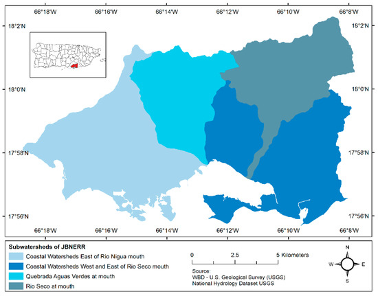
Figure 1.
Study area JBNERR watershed delimitation.
2.2. Methods
Dasymetric mapping can be considered areal interpolation [19]. Dasymetric mapping methods are the geospatial technique that uses land cover classes as ancillary data to accurately calculate and distribute count data through areal interpolation assigned to predetermined boundaries [14]. The census block selection is to provide count data as a set of geographic units that cover JBNERR. The Census Bureau collects and tabulates data in different geographic levels, where the census block is the smallest geographic unit. The census block is delimited by visible features, such as streets, roads, streams, and railroad tracks, and by nonvisible boundaries, such as selected property lines and city, township, school district, and county boundaries [20]. This study’s population per census block is the count data selected to apply the IDM method.
To test the dasymetric mapping performance for JBNERR, the ancillary data for this study area of land use and land cover (LULC) images were used to calculate the population density (Figure 2). The LULC classified images for 1991, 2000, and 2010 were provided by the USDA Forest Service and NOAA Office for Coastal Management. All the LULC images are at a spatial resolution of 30 m following a supervised classification method [21,22]. Previous studies compared and analyzed land change trends using these images because of their classification consistency [23,24,25,26,27]. Therefore, these images were chosen due to the classification consistency, spatial resolution, and the reflection of urban expansion [23]. To derive a comparable grid-level population because the long-term spatial dataset met this criterion, a reclassification process was made to ensure they are comparable.
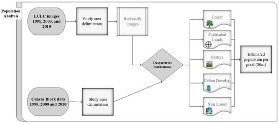
Figure 2.
Census data analysis to create a dasymetric map.
The images were reclassified with five land cover classes following the classification system made by [21] Kennaway and Helmer (2007) for Puerto Rico. The land cover classes are forest, cultivated lands, pasture/grass, urban development, and non-forest (Figure 3). In addition, an integration of georeferencing systems were essential to design the study area throughout the years according to the most recent image. This was important because it allows for a more precise location of the census block of 1990, 2000, and 2010 to the most recent LULC image and on the NAD 1983 Puerto Rico and Virgin Islands coordinate system. The use of this type of system facilitates the visualization of the data obtained on a map to reflect and relate the population distribution and its density
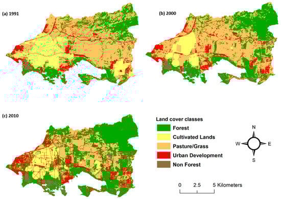
Figure 3.
Land use/cover maps based on the classification system made by Kennaway and Helmer (2007) in 1991, 2000, and 2010.
Using the population and LULC data, a map series was generated using IDM, areal weighting, and the multiclass dasymetric mapping technique. This assumes the population density within each dasymetric zone is uniform. However, since these zones are typically much smaller than the source areas, the result is a more accurate estimate of the population in the target areas compared to the estimate based on areal weighting without ancillary data [14].
2.2.1. Dasymetric Mapping Statistical Approach
The original spatial units containing the data are referred to as the source zones, and the spatial units to which the data are transformed are referred to as the target zones [19]. In dasymetric mapping, the target zones are created from the source zones overlaid with some ancillary spatial data layer, such that the target zones nest perfectly within the source zones [19]. Intelligent dasymetric mapping takes input count data mapped to a set of source zones and a categorical ancillary dataset. It redistributes the data to a set of target zones formed from the source’s intersection and ancillary zones [17]. Data are redistributed based on areal weighting and ancillary classes’ relative densities [13]. Thus, we considered the population in the block unit. The source zone s and ancillary data are zone z, where z is associated with ancillary class c. Then, the target zone t is the area where s and z overlap. The estimated count for a given target zone is calculated as:
Equation (1). Target Zone Estimation
where is the estimated count of the target zone, is the count of the source zone, is the estimated density of ancillary class c, and refers only to the areas of target zones associated with ancillary classes inhabited, i.e., for which the analyst has not enforced a data density of zero. The refers only to the densities of ancillary classes that are populated. This method can employ three sampling options: the containment method, the centroid method, and the percent cover method. In this study, the sampling method chosen is the centroid method because it guarantees a high sample rate, as each source zone centroid falls within an ancillary class zone, but it is vulnerable to outliers [17]. After a sample of source zones has been selected as representative of a particular ancillary class, , it may be calculated as:
Equation (2). Estimated density of ancillary class
where is the number of sampled source zones associated with ancillary class c, and is the area of the source zone. In the case where one or more ancillary classes are assigned a data density of zero by the researcher, the term in Equation (1) refers only to the areas of target zones associated with ancillary classes populated, i.e., for which a data density of zero has not been enforced by the analyst [17]. Additionally, the term in Equation (2) refers only to the densities of ancillary classes that are inhabited. In addition, the term in Equation (2) is replaced by the area of the source zone occupied by inhabited ancillary classes. Even when estimating the population density for more than one inhabited class, it is not a trivial matter from the onset of dasymetric mapping [28]. Therefore, the population of each block was distributed to each grid cell in the population surface based on two factors: (1) the relative difference in population densities among the urban class; and (2) the percentage of the total area of each block occupied by each of the LULC classes. Thus, the high-urbanization grid cell should receive a greater share of the total population assigned to a block or block group than a low- or non-urban-urbanization grid cell in the same block or block group [13].
However, the possibility that a particular ancillary class may go unsampled can occur using the percent cover sampling method. The unsampled class’s density is estimated using “refined” areal weighting [17]. They exposed that the count assigned to each target zone associated with an unsampled class is estimated based on the previously estimated densities of the other ancillary classes that occupy that target zone’s host source zone. For example, consider a source zone that overlaps multiple ancillary zones. Some ancillary zones are associated with an ancillary class that has gone unsampled (denoted ancillary class ) and whose density estimate is unknown. The other ancillary zones are associated with an ancillary class that has a known density estimate (denoted ancillary class ). It was derived from a sampling or a preset density value assigned by the researcher. Then, the count of a target zone associated with is calculated as:
Equation (3). Target Zone Estimation Associated with
where is the estimated count of the target zone associated with u, is the estimated density of , is the area of the target zone associated with , and is the area of the target zone associated with . Note that is a temporary estimate used only to estimate the ancillary class’s density whose density estimate is unknown; it is not the final estimated count for that target zone. Once the value of is found, the estimated density of ancillary class can be calculated using the formula:
Equation (4). Estimated density of u
where is the estimated density of and is the number of target zones in the entire dataset associated with .
Dasymetric approaches provide a more spatially informed interpolation and an understanding of remote sensing techniques and many geographic information system skills [29]. In the next session, the IDM computational steps are discussed. Finally, this method is implemented as a geographic information system (GIS) extension that facilitates the parameterization of the technique and returns a set of statistics that summarizes the quality of the resulting dasymetric (raster) map [17].
2.2.2. Error Assessment
The root means squared error (RMSE) to quantify the error introduced by different areal interpolation methods was used by [30]. They concluded that area-weighting performed poorly compared with intelligent models that utilized ancillary data and that better accuracy was achieved as the number of target zones declined [31]. Meanwhile, [14,19,32] applied dasymetric mapping principles to spatiotemporal interpolation, indicating that the accuracy of estimates was significantly improved especially for urban population analysis. Therefore, it is of great importance to assess the accuracy of this method because high estimation errors were discovered in fast-growing subregions, in areas that were more fully developed for both the source and target periods and in rural settings where land-cover data is known to underestimate developed residential land [12]. To ensure that the source units’ original value was preserved in the transformation to the target units, the pycnophylactic integrity or property proposed by [33] or the volume-preserving requirement explained by [34] should be implemented. However, the method proposed by [17] preserved the pycnophylactic capacity of the dasymetric mapping [35]. This means that when the population count of a source zone was disaggregated and summed back into the source zone, the total should equal that of the original value [31].
The accuracy of the derived population in this study was estimated using RMSE and MAE to show if the number of misplaced persons was either overestimated or underestimated. The root means square error (RMSE) is a statistical error measure calculated as the square root of the sum of squared errors, where the error is the difference between an estimate and the actual value; if the mean error is zero, then it also equals the standard deviation of the error [36]. Then, the assessment error measures were based on the difference between the observed count data and the estimated data in the dataset to assess the accuracy of the population estimation models derived from the census blocks.
Equation (5) Root Mean Square Error
where is the observed population in areal unit i, is the estimated population for the same areal unit, and n is the number of observations. RMSE has the disadvantage of producing large estimation errors for blocks with large population counts [37]. Nevertheless, if the population of the blocks varies greatly, the blocks with high populations tend to have large estimation errors and, therefore, will heavily affect the RMSE measure, while blocks with low people tend to have small estimation errors and less influence on the RMSE measure [30]. Thus, means and medians were used as root mean square averages because of the latter’s lack of robustness to the distorting influence of a few extreme outlying values [38].
To avoid the possibility of accuracy overestimation due to canceling out negative and positive errors, the mean absolute error (MAE) was calculated. An average of the absolute values indicates overall accuracy, including variability/consistency and bias [38]. MAE is a measure of precision calculating the numeric variation between the predicted value and the ‘true’ value indicating how close the estimated values are to the actual values [2].
Equation (6). Mean Absolute Error
where is the estimated population count in block i, is the actual population count in block i, and n is the total number of census blocks.
3. Results
3.1. Population Estimates General Findings
Table 1 summarizes the population growth for JBNERR and Guayama and Salinas municipalities. JBNERR had an estimated population of 28,667 in 1990, 32,489 in 2000, and 34,250 inhabitants in 2010 (Table 1, Figure 4). Population estimates in JBNERR ranged between 41.0% and 44.8% of the total population of both municipalities, respectively, to Guayama and Salinas, from 1990 and 2010 (Table 1). The study area’s population growth rate increased by 1.33% from the 1990s to 2000 but increased slightly from 2000–2010 by 0.54%. The number of new residents increased from one decade, adding 3822 and 1761 new residents from 1990–2000 and 2000–2010, respectively. The study site presents from 1990 to 2000, and from 2000 to 2010 the population significantly increased (13.3%) compared to each municipality where Guayama increased by 6.5%, and Salinas increased by 9.8% from 1990 to 2000.. Similarly, from 2000 to 2010, JBNERR increased 5.4%, while Guayama increased by 2.4%, and Salinas decreased by 0.11%.

Table 1.
Total population comparison between the study area and Guayama and Salinas municipalities.
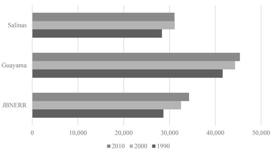
Figure 4.
The population count in the study area and Guayama and Salinas municipalities.
Overall, a review of twenty-year census data revealed that the population residing within the JBNERR watershed increased from 1990 to 2010. The population increased by 19.5% with a growth rate of 0.97%, adding 5583 new residents from 1990 to 2010. In JBNERR, it is important to point out that the number of census blocks increased from one decennial census to the other, respectively, to 829 blocks in 1990, 1118 in 2000, and 1551 blocks in 2010.
3.2. Intelligent Dasymetric Mapping Error Assessment
Table 2 presents the study area’s RMSE and MAE results for population per census block for 1990, 2000, and 2010. This study indicated that the 1990 and 2000 censuses had a root mean squared error (RMSE) of misplaced persons of 2.85 persons and 3.01 persons, respectively. For 2010, the RMSE was 96.52, indicating that the overestimation or underestimation of people is around 97 persons per block in this census. According to previous studies on rural blocks, as is the case of JBNERR, relatively large rural blocks tend to be overestimated, while small urban blocks tend to be underestimated [16,17,38].
Table 2.
Error assessment of IDM method (The values refer to the pixel size, 900 m2).
Regarding the MAE, the population estimation with this approach is 0.10 in 1990, 0.11 in 2000, and 33.21 in 2010, illustrating that the population in 2010 is overestimated, particularly the blocks with larger geographical areas (e.g., blocks in the forest or pasture cover classes). Therefore, it is reasonable to expect that higher accuracy of predicted values at the administrative unit level results in a higher accuracy of the final gridded population distribution datasets [5]. Another explanation is that these might be very small regarding the missing blocks. If they are small enough, then there might be no pixels in the LULC raster with centroids in that block and, therefore, no centroids in the final population density raster. Nevertheless, most of these blocks had zero or a very small population in this study.
In other words, the sum of the estimated population of the dasymetric zones that compose a single original choropleth zone should equal the original encoded population of that choropleth zone [15]. Because the available census data are fine, the dasymetric mapping approach for the final end-user product will still have high accuracy as the census counts “anchor” the end-user product predictions to observed values at a smaller spatial scale [5]. This “anchor” effect minimizes the bias introduced by the “ecological fallacy” by redistributing population data within each census unit to the predicted population density; estimates are guaranteed to at least be accurate when aggregated back to the census unit level [5].
3.3. Dasymetric Population Mapping
Population estimates and density attributes were assigned to each LULC class within each census block using weighted aerial interpolation. Figure 5 shows the suitability of dasymetric mapping to map population density compared to choropleth mapping more accurately. The visual comparison indicates that dasymetric mapping better represented a population density’s spatial orientation, particularly in outlying census blocks encompassing much uninhabited land. In addition, using LULC images as ancillary data was performed positively because these data were directly interpreted as population density estimates over 30 m by 30 m of land.
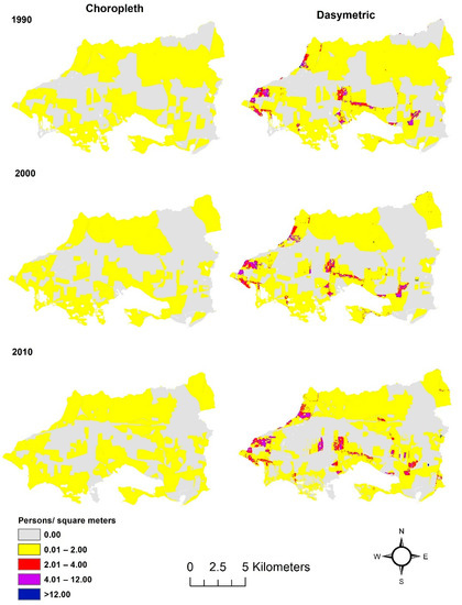
Figure 5.
Visual comparison of the choropleth and the dasymetric population density map for JBNERR census blocks.
Table 3 provides the general results of the weighted aerial interpolation for each land cover class for each year. Results indicate that the population estimates increased steadily for urban development. Table 3 shows that the urban development class has the highest population. In every census, urban development represented 90% or higher than the total population in the study area. The IDM method estimated 26,321 inhabitants in 1990, 29,167 in 2000, and 33,161 inhabitants in 2010. Followed by pasture/grass with 1069, 2561, and 853 inhabitants in 1990, 2000, and 2010. Forest ranked third with the most population with 959, 514, and 236 inhabitants. The less populated land cover classes were cultivated lands and non-forest with 292 and 26 persons in 1990, 22 and 225 persons in 2000, and 0 persons in 2010 estimated, respectively, for these two land cover classes. Comparing the aerial interpolation of the population for each census provides further insight into the type of urban growth throughout JBNERR. Additionally, the results show that the population estimates in cultivated lands decreased from one census to the other. The same occurred to forest land cover.
Table 3.
Dasymetric mapping population statistics summary in JBNERR by census blocks level.
In terms of population density, we found that the highest maximum density corresponds to urban development, with 254.8 ± 12.3 persons/900 m2 in 1990, 71.2 ± 7.1 persons/900 m2 in 2000, and 94.0 ± 4.8 persons/900 m2 in 2010. They were followed by forest 22.0 ± 1.9 persons/900 m2 in 1990. However, for the following censuses, pasture placed second with 20.8 ± 1.4 persons/900 m2 in 2000 and 7.9 ± 0.5 persons/900 m2 in 2010. The population density in forests significantly decreased from one census to the other. In contrast, pasture lands increased their population density from 1990 to 2000 but decreased in 2010.
The dasymetric map of population densities for JBNERR depicted areas with higher population densities within the watershed. Hence, the lowest population densities are found in the north and northeast of the watershed. In contrast, the highest population densities are along the west boundary and close to the coast. Similarly, in the range of 4 to more than 12 persons per pixel, it was observed to intensify from 1990 to 2010 (Figure 6). In areas where the IDM estimated zero population per pixel (grey color) in 1990, those areas presented 2.0 persons per pixel, as the northeast in 2000 and 2010. These two observations reveal that the population was sparsely redistributed according to the land cover areas, and in other parts, the population was intensified.
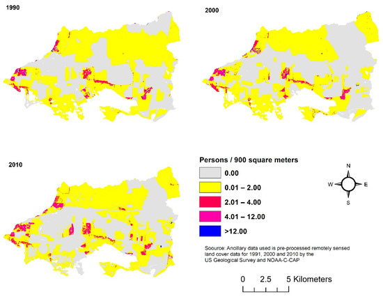
Figure 6.
Dasymetric map of population density in JBNERR.
4. Discussion
This study focuses on analyzing how we can leverage high-resolution land cover datasets for estimating spatiotemporal population in an ecological unique coastal ecosystem for the first time. This approach was applied for the first time at a local scale in JBNERR and provided the potential to update population density using LULC data. In particular, rather than focusing on population dynamics at census blocks scale or focusing on a very large-scale dense populated study area, this study goes a step further and investigates how population changes through applying IDM to link census blocks data to long-term (20-year) high-resolution (30-m) land cover datasets build on existing evidence about how anthropogenics activities are threatening the health of the ecosystem of JBNERR. Likewise, recent studies has shown how IDM contributed with updated high-resolution population density maps for sustainable development policies and human migration at a local and regional level [39,40]. As well, the IDM method application helped explain the vulnerability of human population to environmental health problems for understanding human–environment relationships [41,42,43]. Comparable to previous studies [4,15,16,17,44], our results outperform choropleth maps because they yield more precise population density estimates. Nevertheless, increasing the accuracy of projected changes in population patterns is important for policy and planning initiatives from regional to global scales.
4.1. Uncertainty Sources
The accuracy in this study ranges from the MAE results: the population estimation is 0.10 in 1990, 0.11 in 2000, and 33.21 in 2010. The population in 2010 was overestimated, particularly the blocks with larger geographical areas (e.g., blocks in the forest or pasture cover classes). Those census blocks have zero population counted for our study area. Hence, a geographic unit standardization based on the 2010 census geographic unit is recommended to make comparisons, and further trends can be analyzed. Most notably: when allocating 2000 block counts to 2010 units, uncertainty due to boundary misalignment is pervasive and occasionally large and practically impossible in cases of very small misalignments [45]. Contrary to previous studies that made standardization [12,45,46,47,48,49], our study was lean on the ancillary data comparability classification criteria. Similarly, [4,28,37] point out that the relationship between population density and land use/land cover is non-stationary, not constant over space.
However, even when the multiclass dasymetric mapping has shown to be an effective method for enhancing population mapping, it should recognize another chance of inaccuracy in the census enumeration units, including errors in the satellite imagery process, and it is assumed that population densities are uniform among pixels of the same LULC class. In addition, some inaccuracy on the classification LULC data may affect the population density estimates. Therefore, the error assessment is critical since the most troubling issue for this particular project is that certain regions, such as industrial complexes, that are sparsely populated (in terms of residence) may be classified as high urbanization due to their dense road networks and large areas of impervious surface, the spectral signature of which in T.M. imagery may resemble residential and commercial areas [13].
4.2. Multiclass Dasymetric Mapping
The results from this study provide highly accurate local scale (30 m) distributions of population. In JBNERR, a 30 m2 cell size scale is based on the established relationship between population density and LULC data. The JBNERR watershed can be defined as a rural agricultural small area of 137 km2 with population density ranges from 209 and 237 to 250 people per km2, from 1990 to 2010. This compares to previous studies where the average population density in Jobos Bay is maintained at a comparatively low 234 people per km² by large areas of open space among communities in 2000 [50,51]. The study of [52] revealed that population density is closely related to residential area or dwelling area; thus, much previous research for population estimation was based on housing or dwelling units using high spatial resolution images. Lands around protected areas in Puerto Rico, such as JBNERR, are extremely vulnerable to development and that residential development can continue to grow despite the human population declines [53]. More than 500 housing units have been constructed from 2000 to 2010 in the Jobos Bay watershed area [54]. Our study demonstrated that in JBNERR, the relationship between population density and LULC was non-stationary or constant over time. Therefore, mapping the distributions of human land uses provides critical information for managing landscapes to sustain biodiversity and the structure and function of coastal ecosystems [4,36]. Furthermore, the new environmental indicators extracted from remote sensing imagery and GIS data and the integration of demographic and geographic approaches have significantly improved the estimation accuracy of population counts and housing unit numbers at the census block level [2].
In JBNERR, in the urban areas, the population maximum density decreased from 254.8 ± 12.3 persons/m2 to 71.2 ± 7.1 persons/m2 and increased to 94.0 ± 4.8 persons/m2 in 2010. During this decade in Salinas, the neighborhood of Aguirre, located within the Jobos watershed, reflected an increase in its population by 15.5% [55]. Even when Aguirre experienced a population gain, the Salinas municipality experienced a population loss from 2000 to 2010. This population loss in the Salinas neighborhood represents a trend that has been experienced in most of the urban centers of the municipalities of Puerto Rico [55]. For its part in Guayama, where to the west is JBNERR, the industrial area, the floodplain of the Guamaní River, and the Caribbean Sea to the south [56] experienced population growth from 2000 to 2010. The Jobos barrio, located within the Jobos watershed, also presented an increase in population of 7.53% and its housing units by 17.8% from 2000 to 2010 [57]. Meanwhile, pasture/grass as open spaces increased its population maximum density from 1990 to 2000 but decreased from 2000 to 2010, contrary to urban areas in our study area. The population density decreased in cultivated lands as well as in forest land cover. This means that pasture areas became urbanized as urban sprawl with dispersed density in population and housing development while forest land extension increased over the study period.
5. Conclusions
This study aims to analyze how the high-resolution LULC imagery dataset improved population mapping using census blocks for the first time in a unique estuarine reserve in Puerto Rico included in the National Estuarine System of the NOAA Office of Coastal Management. We demonstrate the synergistic value of combining these datasets by demonstrating the complementary effect of improving the accuracy of population estimates, particularly for urban areas, which are important for their impact on the reserve’s ecological functions and social benefits. Furthermore, this study helps further explore how the estuarine ecosystem will react if urban development continues in and around the reserve for future study. Thus, our results demonstrated an effective workflow that allows proper multiclass dasymetric mapping processing to estimate the residential population’s geospatial distribution. Finally, our methods and results help assess the impact of urban growth in ecologically fragile areas, such as urban development in JBNERR, that may indirectly threaten recreational activities and ecological environments within protected areas.
Author Contributions
M.C.-C. and H.M. contributed to the conceptualization and implementation of the research methodology. M.C.-C. and C.W. contributed to the writing and editing of the manuscript, validation, and formal analysis of the results. All authors have read and agreed to the published version of the manuscript.
Funding
This study was funded by the Puerto Rico NASA Space Grant Consortium (Grant 80NSSC20M0052).
Institutional Review Board Statement
Not applicable.
Informed Consent Statement
Not applicable.
Data Availability Statement
The data are available on request from the corresponding author.
Acknowledgments
We are grateful to Qiong Gao from the Environmental Sciences Department at the University of Puerto Rico for the insightful comments and suggestions, which have greatly improved the content of this manuscript.
Conflicts of Interest
The authors declare no conflict of interest. The funders had no role in the research design, analyses, or interpretation of data, in the writing of the manuscript, or in the decision to publish the results.
Abbreviations
| JBNERR | Jobos Bay National Estuarine Research Reserve |
| JBW | Jobos Bay Watershed |
| LULC | land use and land cover |
| IDM | intelligent dasymetric mapping |
References
- Brown, D.G.; Johnson, K.M.; Loveland, T.R.; Theobald, D.M. Rural Land-Use Trends in the Conterminous United States, 1950–2000. Ecol. Appl. 2005, 15, 1851–1863. [Google Scholar] [CrossRef]
- Deng, C. Small-Area Population Estimation: An Integration of Demographic and Geographic Techniques. Ph.D. Thesis, University of Wisconsin-Milwaukee, Milwaukee, WI, USA, 2013. [Google Scholar]
- Smith, S.K.; Nogle, J.; Cody, S. A Regression Approach to Estimate the Average Number of Persons per Household. Demography 2002, 39, 697–712. [Google Scholar] [CrossRef] [PubMed]
- Su, M.D.; Lin, M.C.; Hsieh, H.I.; Tsai, B.W.; Lin, C.H. Multi-Layer Multi-Class Dasymetric Mapping to Estimate Population Distribution. Sci. Total Environ. 2010, 408, 4807–4816. [Google Scholar] [CrossRef]
- Stevens, F.R.; Gaughan, A.E.; Linard, C.; Tatem, A.J. Disaggregating Census Data for Population Mapping Using Random Forests with Remotely-Sensed and Ancillary Data. PLoS ONE 2015, 10, e0107042. [Google Scholar] [CrossRef] [PubMed]
- Fisher, P.F.; Langford, M. Modeling Sensitivity to Accuracy in Classified Imagery: A Study of Areal Interpolation by Dasymetric Mapping. Prof. Geogr. 1996, 48, 299–309. [Google Scholar] [CrossRef]
- Weichselbaum, J.; Papathoma, M. Sharpening Census Information in GIS to Meet Real-World Conditions—The Case for Earth Observation. WIT Trans. Ecol. Environ. 2005, 84, 143–152. [Google Scholar]
- Holloway, S.R.; Schumacher, J.; Redmond, R.L. People and Place: Dasymetric Mapping Using Arc/Info. Cartographic Design Using ArcView and Arc/Info, Missoula Wildl. Spat. Anal. Lab. 1997. Available online: http://pdi.topografia.upm.es/mab/apuntesalumnos/Para%20tema7.PDF (accessed on 26 October 2022).
- Wu, S.S.; Qiu, X.; Wang, L. Population Estimation Methods in GIS and Remote Sensing: A Review. GISci. Remote Sens. 2005, 42, 80–96. [Google Scholar] [CrossRef]
- Wright, J.K. A Method of Mapping Densities of Populatrion with Cape Cod as an Example. Geogr. Rev. 1936, 26, 103–110. [Google Scholar] [CrossRef]
- Langford, M.; Unwin, D.J. Generating and Mapping Population Density Surfaces within a Geographical Information System. Cartogr. J. 1994, 31, 21–26. [Google Scholar] [CrossRef]
- Zoraghein, H.; Leyk, S.; Ruther, M.; Buttenfield, B.P. Exploiting Temporal Information in Parcel Data to Refine Small Area Population Estimates. Comput. Environ. Urban Syst. 2016, 58, 19–28. [Google Scholar] [CrossRef]
- Mennis, J. Generating Surface Models of Population Using Dasymetric Mapping. Prof. Geogr. 2003, 55, 31–42. [Google Scholar] [CrossRef]
- Zandbergen, P.A.; Ignizio, D.A. Comparison of Dasymetric Mapping Techniques for Small-Area Population Estimates. Cartogr. Geogr. Inf. Sci. 2010, 37, 199–214. [Google Scholar] [CrossRef]
- Mennis, J. Dasymetric Mapping for Estimating Population in Small Areas. Geogr. Compass 2009, 3, 727–745. [Google Scholar] [CrossRef]
- Eicher, C.L.; Brewer, C.A. Dasymetric Mapping and Areal Interpolation: Implementation and Evaluation. Cartogr. Geogr. Inf. Sci. 2001, 28, 125–138. [Google Scholar] [CrossRef]
- Mennis, J.; Hultgren, T. Intelligent Dasymetric Mapping and Its Application to Areal Interpolation. Cartogr. Geogr. Inf. Sci. 2006, 33, 179–194. [Google Scholar] [CrossRef]
- Kennish, M.J. Environmental Threats and Environmental Future of Estuaries. Environ. Conserv. 2002, 29, 78–107. [Google Scholar] [CrossRef]
- Mennis, J. Dasymetric Spatiotemporal Interpolation. Prof. Geogr. 2016, 68, 92–102. [Google Scholar] [CrossRef]
- Rossiter, K. What Are Census Blocks? US Census Bureau. 2011. Available online: https://www.census.gov/newsroom/blogs/random-samplings/2011/07/what-are-census-blocks.html (accessed on 26 October 2022). Geogr. Meas. Am. People, Places, Econ.
- Kennaway, T.; Helmer, E. The Forest Types and Ages Cleared for Land Development in Puerto Rico. GISci. Remote Sens. 2007, 44, 356–382. [Google Scholar] [CrossRef]
- NOAA Office for Coastal Management (NOAA/OCM). C-CAP Land Cover, Puerto Rico, 2010 ID: 48301, InPort. Available online: https://inport.nmfs.noaa.gov/inport/item/48301 (accessed on 17 September 2019).
- Gao, Q.; Yu, M. Discerning Fragmentation Dynamics of Tropical Forest and Wetland during Reforestation, Urban Sprawl, and Policy Shifts. PLoS ONE 2014, 9, 1–11. [Google Scholar] [CrossRef]
- Comarazamy, D.E.; González, J.E.; Luvall, J.C. Quantification and Mitigation of Long-Term Impacts of Urbanization and Climate Change in the Tropical Coastal City of San Juan, Puerto Rico. Int. J. Low-Carbon Technol. 2015, 10, 87–97. [Google Scholar] [CrossRef]
- Bridgman, B.; Maio, M.; Schmitz, J.A. What Ever Happened to the Puerto Rican Sugar Manufacturing Industry? Federal Reserve Bank of Minneapolis: Minneapolis, MN, USA, 2012. [Google Scholar]
- Wang, C.; Yu, M.; Gao, Q. Continued Reforestation and Urban Expansion in the New Century of a Tropical Island in the Caribbean. Remote Sens. 2017, 9, 731. [Google Scholar] [CrossRef]
- Ramos-Scharrón, C.E.; Torres-Pulliza, D.; Hernández-Delgado, E.A. Watershed- and Island Wide-Scale Land Cover Changes in Puerto Rico (1930s–2004) and Their Potential Effects on Coral Reef Ecosystems. Sci. Total Environ. 2015, 506–507, 241–251. [Google Scholar] [CrossRef] [PubMed]
- Mitsova, D.; Esnard, A.M.; Li, Y. Using Enhanced Dasymetric Mapping Techniques to Improve the Spatial Accuracy of Sea Level Rise Vulnerability Assessments. J. Coast. Conserv. 2012, 16, 355–372. [Google Scholar] [CrossRef]
- Zeng, W.; Comber, A. Using Household Counts as Ancillary Information for Areal Interpolation of Population: Comparing Formal and Informal, Online Data Sources. Comput. Environ. Urban Syst. 2020, 80, 101440. [Google Scholar] [CrossRef]
- Fisher, P.F.; Langford, M. Modelling the Errors in Areal Interpolation between Zonal Systems by Monte Carlo Simulation. Environ. Plan. A 1995, 27, 211–224. [Google Scholar] [CrossRef]
- Qiu, F.; Zhang, C.; Zhou, Y. The Development of an Areal Interpolation ArcGIS Extension and a Comparative Study. GISci. Remote Sens. 2012, 49, 644–663. [Google Scholar] [CrossRef]
- Mennis, J. Increasing the Accuracy of Urban Population Analysis with Dasymetric Mapping. Cityscape 2015, 17, 115–126. [Google Scholar]
- Tobler, W.R. Smooth Pycnophylactic Interpolation for Geographical Regions. J. Am. Stat. Assoc. 1979, 74, 519–530. [Google Scholar] [CrossRef]
- Lam, N.S.N. Spatial Interpolation Methods: A Review. Am. Cart. 1983, 10, 129–150. [Google Scholar] [CrossRef]
- Neves, O.M.d.S.; Strauch, J.C.M.; Ajara, C. Dasymetric Methods Applied to Jacarepaguá Watershed. Bol. Ciências Geodésicas 2017, 23, 606–622. [Google Scholar] [CrossRef]
- Titus, J.G.; Anderson, K.E.; Cahoon, D.R.; Gesch, D.B.; Gill, S.K.; Gutierrez, B.T.; Thieler, E.R.; Williams, S.J. The First State of the Coastal Cycle Sensitivity to Carbon Report Sea-Level Rise: Focus on Mid-Atlantic Region; U.S. Climate Change Science Program: Washington, DC, USA, 2009. [Google Scholar]
- Qiu, F.; Sridharan, H.; Chun, Y. Spatial Autoregressive Model for Population Estimation at the Census Block Level Using LIDAR-Derived Building Volume Information. Cartogr. Geogr. Inf. Sci. 2010, 37, 239–257. [Google Scholar] [CrossRef]
- Harvey, J.T. Estimating Census District Populations from Satellite Imagery: Some Approaches and Limitations. Int. J. Remote Sens. 2002, 23, 2071–2095. [Google Scholar] [CrossRef]
- Aquilino, M.; Adamo, M.; Blonda, P.; Barbanente, A.; Tarantino, C. Improvement of a Dasymetric Method for Implementing Sustainable Development Goal 11 Indicators at an Intra-Urban Scale. Remote Sens. 2021, 13, 1–34. [Google Scholar] [CrossRef]
- Aquilino, M.; Tarantino, C.; Adamo, M.; Barbanente, A.; Blonda, P. Earth Observation for the Implementation of Sustainable Development Goal 11 Indicators at Local Scale: Monitoring of the Migrant Population Distribution. Remote Sens. 2020, 12, 1–21. [Google Scholar] [CrossRef]
- Cleckner, H.; Allen, T.R. Dasymetric Mapping and Spatial Modeling of Mosquito Vector Exposure, Chesapeake, Virginia, USA. ISPRS Int. J. Geo-Inf. 2014, 3, 891–913. [Google Scholar] [CrossRef]
- Peña, E.N. Using Census Data, Urban Land-Cover Classification, and Dasymetric Mapping to Measure Urban Growth of the Lower Rio Grande Valley, Texas; University of Southern California: Los Angeles, CA, USA, 2012. [Google Scholar]
- Baynes, J.; Neale, A.; Hultgren, T. Improving Intelligent Dasymetric Mapping Population Density Estimates at 30ĝ€¯m Resolution for the Conterminous United States by Excluding Uninhabited Areas. Earth Syst. Sci. Data 2022, 14, 2833–2849. [Google Scholar] [CrossRef]
- Holt, J.B.; Lo, C.P.; Hodler, T.W. Dasymetric Estimation of Population Density and Areal Interpolation of Census Data. Cartogr. Geogr. Inf. Sci. 2004, 31, 103–121. [Google Scholar] [CrossRef]
- Schroeder, J.P. Hybrid Areal Interpolation of Census Counts from 2000 Blocks to 2010 Geographies. Comput. Environ. Urban Syst. 2017, 62, 53–63. [Google Scholar] [CrossRef]
- Zoraghein, H.; Leyk, S. Enhancing Areal Interpolation Frameworks through Dasymetric Refinement to Create Consistent Population Estimates across Censuses. Int. J. Geogr. Inf. Sci. 2018, 32, 1948–1976. [Google Scholar] [CrossRef]
- Schroeder, J.P. Target-Density Weighting Interpolation and Uncertainty Evaluation for Temporal Analysis of Census Data. Geogr. Anal. 2007, 39, 311–335. [Google Scholar] [CrossRef]
- Schroeder, J.P.; Van Riper, D.C. Because Muncie’s Densities Are Not Manhattan’s: Using Geographical Weighting in the Expectation-Maximization Algorithm for Areal Interpolation. Geogr. Anal. 2013, 45, 216–237. [Google Scholar] [CrossRef] [PubMed]
- Ruther, M.; Leyk, S.; Buttenfield, B.P. Comparing the Effects of an NLCD-Derived Dasymetric Refinement on Estimation Accuracies for Multiple Areal Interpolation Methods. GISci. Remote Sens. 2015, 52, 158–178. [Google Scholar] [CrossRef]
- Whitall, D.R.; Costa, B.M.; Bauer, L.J.; Dieppa, A.; Hile, S.D. A Baseline Assessment of the Ecological Resources of Jobos Bay, Puerto Rico; NOAA Technical Memorandum NOS NCCOS 133 Publisher: Silver Spring, MD, USA, 2011. [Google Scholar]
- Apeti, D.A.; Whitall, D.R.; Pait, A.S.; Dieppa, A.; Zitello, A.G.; Lauenstein, G.G. Characterization of Land-Based Sources of Pollution in Jobos Bay, Puerto Rico: Status of Heavy Metal Concentration in Bed Sediment. Environ. Monit. Assess. 2012, 184, 811–830. [Google Scholar] [CrossRef] [PubMed]
- Li, L.; Lu, D. Mapping Population Density Distribution at Multiple Scales in Zhejiang Province Using Landsat Thematic Mapper and Census Data. Int. J. Remote Sens. 2016, 37, 4243–4260. [Google Scholar] [CrossRef]
- Castro-Prieto, J.; Martinuzzi, S.; Radeloff, V.C.; Helmers, D.P.; Quiñones, M.; Gould, W.A. Declining Human Population but Increasing Residential Development around Protected Areas in Puerto Rico. Biol. Conserv. 2017, 209, 473–481. [Google Scholar] [CrossRef]
- Field, R.; Laboy, E.N.; Capellla, J.; Robles, P.O.; González, C.M. Jobos Bay Estuarine Profile: A National Estuarine Research Reserve; Jobos Bay National Estuarine Research Reserve: Salinas, Puerto Rico, 2008. [Google Scholar]
- Junta de Planificación de Puerto Rico. Plan de Mitigación de Peligros Naturales. Municipio de Salinas Versión Final (Natural Hazards Mitigation Plan. Salinas Municipality. Final Versión); Junta de Planificación de Puerto Rico Publisher: Salinas, Puerto Rico, 2019. [Google Scholar]
- Junta de Planificación de Puerto Rico. Plan de Mitigación de Peligros Naturales. Municipio de Guayama. Versión Final (Natural Hazards Mitigation Plan. Guayama Municipality. Final Version); Junta de Planificación de Puerto Rico Guayama: San Juan, Puerto Rico, 2020. [Google Scholar]
- US Census Bureau 2010 Census. TIGER/Line Shapefiles Technical Documentation; US Census Bureau: Washington, DC, USA, 2012. [Google Scholar]


Publisher’s Note: MDPI stays neutral with regard to jurisdictional claims in published maps and institutional affiliations. |
© 2022 by the authors. Licensee MDPI, Basel, Switzerland. This article is an open access article distributed under the terms and conditions of the Creative Commons Attribution (CC BY) license (https://creativecommons.org/licenses/by/4.0/).