


Historical Centres, Protected Natural Areas, Communities and Sustainable Development: A Possible Balance


Abstract
:1. Introduction
2. Method and Methodology
2.1. Territorialist Approach and Protected Natural Areas
2.2. Small Municipalities in Italy: Quantity and Qualitative Data
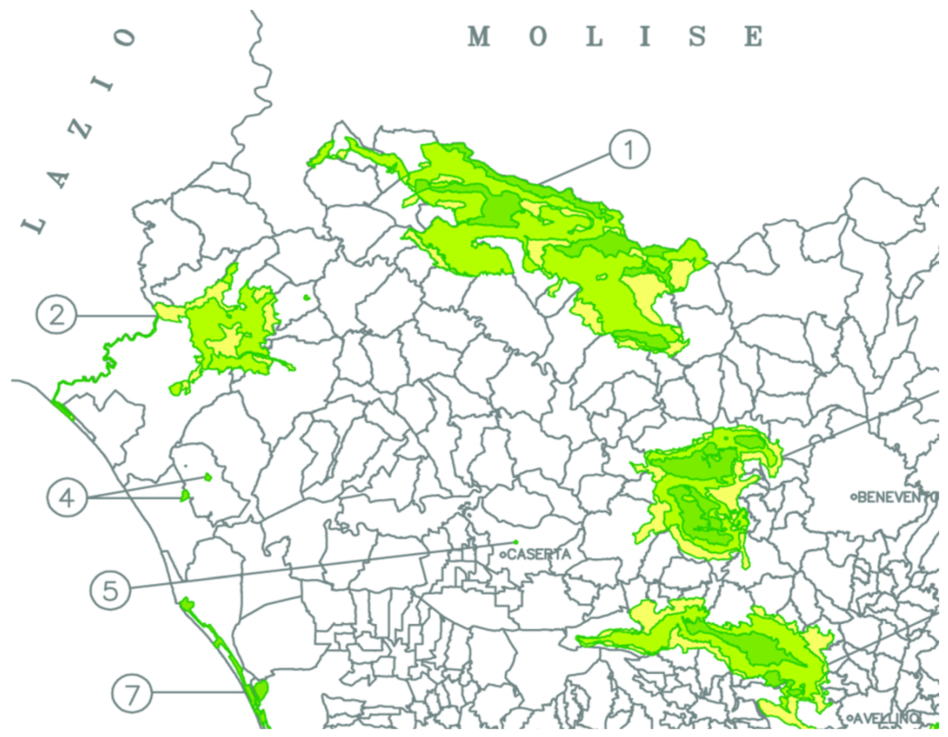
2.3. The Case Study of the ‘Parco Regionale Area Vulcanica di Roccamonfina e Foce Garigliano’
2.4. The Case Study of the Roccamonfina-Foce Garigliano Regional Park
2.5. Tools
3. Results
4. Discussion
5. Conclusions
Author Contributions
Funding
Data Availability Statement
Acknowledgments
Conflicts of Interest
| 1 | Naturalistic policies are linked to landscape, urban, infrastructural and social issues among others. The first consequence has been the affirmation of a new conception of the relations between protected areas and the territory, which leads to the interweaving of protection and development policies, to the systematic extension of attention to environmental contexts that are much broader than the protected areas, to making decision-making and management processes more complex, but at the same time more significant, by involving local institutions and actors. |
| 2 | The 2013 Mediterranean Diet recognition document, which, starting from the assumption that the term ‘diet’ derives from the Greek diaīta, i.e., ‘lifestyle’, attributes to the element an example of sustainable development in full compliance with existing international human rights instruments and the need for mutual respect among communities, groups and individuals. The document emphasises the use of the element as an example, for the entire international community, by the most important agencies of the United Nations, such as the FAO (Food and Agriculture Organisation), which considers it a model of a sustainable diet that respects natural resources and biodiversity, local landscapes and the environment, and the World Health Organisation (WHO), which recognises it as a nutritional model that contributes to the health and wellbeing of populations. The Mediterranean Diet thus becomes a paradigm of permanent dialogue with nature, guided by respect for cultural, biological and environmental diversity, as well as hospitality, neighbourliness, sharing, intercultural dialogue, mutual respect and creativity. |
| 3 | The Orange Flag is a recognition of tourist-environmental quality awarded by the “Touring Club Italiano” to small inland municipalities, with a population of no more than 15,000, that stand out for their qualifying offer and reception. The ‘Touring Club Italiano’ (TCI) is a non-profit association, intending to promote tourism throughout Italy, founded in 1894 in Milan. |
| 4 | The bodies of the park authority are (a) the president; (b) the executive board; (c) the executive council; (d) the board of auditors; (e) the park community. |
| 5 | In Italy, regional regulations are included in regional laws implementing national law, as in the case of Campania Regional Law No 33 of 01/09/1993. |
References
- Bertini, A. Introduzione. Aree protette, comunità locali e centri abitati. In Aree Protette in Italia. Il caso della Campania; Bertini, A., Nicoletti, D., Vitolo, G.F.R.T., Eds.; Rubbettino: Soveria Mannelli (Catanzaro), Italy, 2015; p. 15. [Google Scholar]
- Gazzetta Ufficiale, serie generale n. 292 del 13/12/1991—suppl. ordinario n. 83 “Legge quadro sulle aree protette”, n. 394 del 6 dicembre 1991.
- Available online: https://ambientenonsolo.com/764mila-di-aree-terrestri-protette-in-europa-i-dati-eurostat/ (accessed on 21 November 2022).
- Gazzetta Ufficiale, serie generale n. 125 del 31/05/2010—suppl. ordinario n. 125. Decreto 27 Aprile 2010 del Ministero dell’Ambiente e della Tutela del Territorio e del Mare.
- Bertini, A. Per i centri abitati “poco noti”. In Turismi e Turisti. Politica, Innovazione, Economia in Italia in Età Contemporanea; Avallone, P., Strangio, D., Eds.; Franco Angeli Editore: Milano, Italy, 2015; pp. 207–226. [Google Scholar]
- Bertini, A.; Vitolo, T. Sustainable tourism development: Best practices and inland areas. In Post COVID-19 Tourism: A Pathway towards Sustainable Development in the Mediterranean Region; Buonincontri, P., Errichiello, L., Micera, R., Eds.; Graw Hill: Milano, Italy, 2015; pp. 85–100. [Google Scholar]
- Paladino, M. Il Sistema delle aree Parco della Regione Campania, Asita 2017, pp. 804–805.
- Bertini, A.; Caruso, I.; Vitolo, T. Inland Areas, Protected Natural Areas and Sustainable Development. Eng. Proc. 2022, 18, 20. [Google Scholar] [CrossRef]
- Costanzo, L.; Ferrara, A. Paesaggio e patrimonio culturale. In Bes; 2021; p. 170. Available online: https://www.istat.it/it/files/2022/04/9.pdf (accessed on 21 November 2022).
- Resce, M. (Ed.) Le Aree Protette: Vincolo o Opportunità. In Istituto per lo Sviluppo della Formazione Professionale dei Lavoratori; Isfol: Rome, Italy, 2013; p. 20. [Google Scholar]
- Strategia Nazionale delle Aree Interne. Available online: https://www.agenziacoesione.gov.it/strategia-nazionale-aree-interne/#:~:text=La%20Strategia%20Nazionale%20per%20le,aree%20interne%20del%20nostro%20Paese (accessed on 21 November 2022).
- Strategia Energetica Nazionale (SEN), approvata con decreto congiunto dei Ministri dell’ambiente e dello sviluppo economico l’8 marzo scorso. Available online: https://www.mise.gov.it/images/stories/documenti/Testo-integrale-SEN-2017.pdf (accessed on 21 November 2022).
- Ministero Dell’ambiente Dalla Legge n. 221 del 28 Dicembre 2015 Conseguente l’Agenda 2030 per lo Sviluppo Sostenibile (Ministero Dell’ambiente e Della Tutela del Territorio). Available online: https://www.bosettiegatti.eu/info/norme/statali/2015_0221.htm (accessed on 21 November 2022).
- GU Serie Generale n.256 del 02-11-2017. Available online: https://www.gazzettaufficiale.it/gazzetta/serie_generale/caricaDettaglio?dataPubblicazioneGazzetta=2022-11-02&numeroGazzetta=256 (accessed on 31 January 2023).
- Bonomi, A.; Masiero, R. Dalla Smart City Alla Smart Land; Marsilio Editori: Venezia, Italy, 2014. [Google Scholar]
- Accordo di Partenariato 2014–2020. Strategia Nazionale per le Aree Interne: Definizione, Obiettivi, Strumenti e Governance. Documento Tecnico Collegato alla Bozza di Accordo di Partenariato Trasmessa Alla CE il 9 Dicembre 2013. Available online: https://opencoesione.gov.it/it/adp_2014_2020/ (accessed on 22 November 2022).
- Bressanelli, G. The role of digital technologies to overcome Circular Economie challenges in PSS Business Models: An exploratory case study. Procedia CIRP 2018, 73, 216–221. [Google Scholar] [CrossRef]


| Year | Resident Population | Absolute Variation | % |
|---|---|---|---|
| 2001 | 5,701,389 | - | - |
| 2002 | 5,725,098 | +23,709 | +0.42% |
| 2003 | 5,760,353 | +35,255 | +0.62% |
| 2004 | 5,788,986 | +28,633 | +0.50% |
| 2005 | 5,790,929 | +1943 | +0.03% |
| 2006 | 5,790,187 | −742 | −0.01% |
| 2007 | 5,811,390 | +21,203 | +0.37% |
| 2008 | 5,812,962 | +1572 | +0.03% |
| 2009 | 5,824,662 | +11,700 | +0.20% |
| 2010 | 5,834,056 | +9394 | +0.16% |
| 2011 | 5,836,317 | +2261 | +0.04% |
| 2012 | 5,769,750 | +5326 | +0.09% |
| 2013 | 5,869,965 | +100,215 | +1.74% |
| 2014 | 5,861,529 | −8436 | −0.14% |
| 2015 | 5,850,850 | −10,679 | −0.18% |
| 2016 | 5,839,084 | −11,766 | −0.20% |
| 2017 | 5,826,860 | −12,224 | −0.21% |
| 2018 | 5,740,291 | −86,569 | −1.49% |
| 2019 | 5,712,143 | −28,148 | −0.49% |
| 2020 | 5,624,260 | −87,883 | −1.54% |
| Denomination | ha | Morpho-Typology | |
|---|---|---|---|
| NP | Cilento, Vallo di Diano e Monti Alburni | 181,048.00 | Coastal, inland and river archaeological |
| NP | Vesuvio | 8482.00 | Inland volcanic and metropolitan |
| RP | Campi Flegrei | 7350.00 | Coastal, marine, inland, lacustrine, volcanic, archaeological, thermal |
| RP | Matese | 33,326.53 | Inland, mountainous, lacustrine, archaeological |
| RP | Monti Lattari | 16,000.00 | Inland, coastal mountainous, archaeological |
| RP | Monti Picentini | 62,200.00 | Inland hill mountane fluvial |
| RP | Partenio | 14,870.00 | Inland hill mountane |
| RP | Roccamonfina e Foce Garigliano | 11,000.00 | Inland, volcanic, hilly, fluvial, thermal coastal |
| RP | Taburno-Camposauro | 12,370.00 | Inland upland |
| RP | Fiume Sarno | 3436.00 | Fluvial, archaeological |
| MR | Costa degli Infreschi e della Masseta | 2332.00 | Marina: coastal |
| MR | Punta Campanella | 1539.00 | Marina: coastal and island |
| MR | Regno di Nettuno | 11,256.00 | Marina: coastal and island |
| MR | Santa Maria di Castellabate | 7095.00 | Marina: coastal |
| UAP | Baia | 176.60 | Marine: coastal and archaeological |
| UAP | Gaiola | 41.60 | Marine: coastal and archaeological |
| SR | Castelvolturno | 268.14 | Coastal and lacustrine |
| SR | Cratere degli Astroni | 250.00 | Inland, volcanic, metropolitan area |
| SR | Isola di Vivara | 35.63 | Coastal, island, volcanic |
| SR | Tirone Alto Vesuvio | 1005.00 | Inland forested |
| SR | Valle delle Ferriere | 455.00 | Inland fluvial, archaeological-industrial |
| RR | Foce Sele e Tanagro | 6900.00 | Fluvial and coastal |
| RR | Foce Volturno e Costa di Licola | 1540.00 | Coastal, fluvial and lacustrine |
| RR | Lago Falciano | 9.00 | Lacustrine inland |
| RR | Monti Eremita Marzano | 1500.00 | Inland mountainous |
| RUP | Parco delle Colline di Napoli | 2215.00 | Internal metropolitan area |
| OPA | Baia di Ieranto | 50 | Coastal |
| OPA | Bosco di San Silvestro | 76 | Inland wooded |
| OPA | Diecimare | 444 | Inland wooded |
| OPA | Monte Polveracchio | 200 | Inland, mountainous and lacustrine |
| Total | 387,551.50 |
| Caciocavallo Silano | PN Cilento, Vallo di Diano e Monti Alburni | |
| Cipollotto Nocerino | Dop | PR del bacino fiume Sarno |
| Colatura di alici di Cetara | Dop | PR Monti Lattari |
| Cilento white fig | Dop | PN Cilento, Vallo di Diano e Monti Alburni |
| Mozzarella di Bufala Campana | PR Area vulcanica di Roccamonfina e foce Garigliano | |
| Cilento extra virgin olive oil | PN Cilento, Vallo di Diano e Monti Alburni | |
| Colline Salernitane extra virgin olive oil | PN Cilento, Vallo di Diano e Monti Alburni | |
| Irpinia extra virgin olive oil—Colline dell’Ufita | ||
| Sorrento Peninsula extra virgin olive oil | PR Monti Lattari | |
| Extra virgin olive oil Terre Aurunche | PR Area vulcanica di Roccamonfina e foce Garigliano | |
| Olive of Gaeta | PR Area vulcanica di Roccamonfina e foce Garigliano | |
| Piennolo del Vesuvio tomato | PN Vesuvio | |
| S. Marzano tomato from Agro Sarnese-nocerino | PR del bacino fiume Sarno | |
| Provolone del Monaco | PR Monti Lattari | |
| Ricotta di Bufala Campana | PN Cilento, Vallo di Diano e Monti Alburni | |
| PGIs recognized by the European Union | ||
| Paestum Artichoke | PN Cilento, Vallo di Diano e Monti Alburni | |
| Montella chestnut | PR dei Monti Picentini | |
| Roccamonfina chestnut | PR Area vulcanica di Roccamonfina e foce Garigliano | |
| Amalfi Coast Lemon | PR Monti Lattari | |
| Sorrento Lemon | PR Monti Lattari | |
| Marrone / Chestnut of Serino | PR dei Monti Picentini | |
| Marrone of Roccadaspide | PR Area Vulcanica di Roccamonfina e foce Garigliano | |
| Mela annurca Campana | PR del Taburno-Camposauro | |
| Giffoni Hazelnut | PR dei Monti Picentini | |
| Campania IGP olive oil | Tutti i parchi | |
| Gragnano Pasta | PR dei Monti Lattari | |
| Rocket from Piana del Sele | PN Cilento, Vallo di Diano e Monti Alburni e PR dei Picentini | |
| White Veal of the Central Apennines | Provincie Benevento e Avellino | |
| PGI pending | ||
| Bracigliano cherry PGI | PR dei Monti Picentini | |
| Irpinia Hazelnut PGI | PR del Partenio | |
| Peeled Tomato of Naples PGI | PR del bacino fiume Sarno | |
| Wine | Certification | Regional Parks |
|---|---|---|
| Aglianico del Taburno | Doc | Taburno Camposauro |
| Aversa | Doc | Campi Flegrei |
| Campania | Igt | Picentini |
| Campi Flegrei | Doc | Campi Flegrei |
| Costa d’Amalfi | Doc | Monti Lattari |
| Falerno del Massico | Doc | Area Vulcanica di Roccamonfina e Foce Garigliano |
| Fiano di Avellino | Doc | Partenio |
| Galluccio | Doc | Area vulcanica di Roccamonfina e Foce Garigliano |
| Greco di Tufo | Docg | Picentini |
| Irpinia | Doc | Picentini |
| Ischia | Doc | Regno di Nettuno |
| Penisola sorrentina | Doc | Monti Lattari |
| Taurasi | Docg | Picentini |
| Typology | |||||||||
|---|---|---|---|---|---|---|---|---|---|
| Municipality | Agritourism | Country House | B&B | Holiday Apartment | Hotel | Guest house | Holiday Village | Camping | Residence |
| Conca della Campania | 3 | 1 | - | - | - | - | - | - | - |
| Galluccio | 3 | 3 | - | - | - | - | - | - | - |
| Marzano Appio | - | 2 | 3 | 1 | - | - | - | - | - |
| Roccamonfina | 2 | - | 3 | - | 2 | 2 | - | - | - |
| Sessa Aurunca | 2 | - | 3 | - | 6 | - | 1 | 2 | 1 |
| Teano | 9 | - | 4 | - | - | - | - | - | - |
| Tora e Piccilli | - | 1 | 1 | - | - | - | - | - | |
| Totals | 19 | 7 | 10 | 2 | 8 | 2 | 1 | 2 | 1 |
| Small Municipalities | Resident Population | Land Area | ||||
|---|---|---|---|---|---|---|
| N. | % | N. | % | N. | % | |
| Piemonte | 1046 | 89 | 1,305,774 | 30 | 20,018 | 79 |
| Valle d’Aosta | 73 | 99 | 92,704 | 73 | 3240 | 99 |
| Lombardia | 1043 | 69 | 2,097,223 | 22 | 15,262 | 64 |
| Trentino-Alto Adige | 256 | 88 | 455,679 | 44 | 10,864 | 80 |
| Veneto | 289 | 51 | 747,112 | 15 | 8032 | 44 |
| Friuli-Venezia Giulia | 151 | 70 | 278,111 | 23 | 5494 | 70 |
| Liguria | 182 | 78 | 246,230 | 16 | 3900 | 72 |
| Emilia Romagna | 135 | 41 | 362,755 | 8 | 8984 | 40 |
| Toscana | 119 | 44 | 289,667 | 8 | 9478 | 41 |
| Umbria | 61 | 66 | 134,402 | 15 | 3333 | 39 |
| Marche | 160 | 70 | 320,231 | 21 | 5081 | 54 |
| Lazio | 254 | 67 | 461,258 | 8 | 7502 | 44 |
| Abruzzo | 250 | 82 | 356,367 | 27 | 7605 | 70 |
| Molise | 125 | 92 | 153,962 | 49 | 3654 | 82 |
| Campania | 335 | 61 | 693,521 | 12 | 7962 | 58 |
| Puglia | 84 | 33 | 215,437 | 5 | 2794 | 14 |
| Basilicata | 99 | 76 | 191,044 | 33 | 5844 | 58 |
| Calabria | 322 | 80 | 646,343 | 33 | 10,227 | 67 |
| Sicilia | 202 | 52 | 493,766 | 10 | 8348 | 32 |
| Sardegna | 314 | 83 | 526,627 | 32 | 16,931 | 70 |
| Totals | 5500 | 69 | 10,068,213 | 17 | 164,554 | 54 |
| Type | Denomination | n.T.C. | n.C.A. |
|---|---|---|---|
| National Park | Vesuvio | 13 | 0 |
| National Park | Cilento e Vallo di Diano | 80 | 77 |
| Regional park | Matese | 15 | 4 |
| Regional park | Area vulcanica Roccamonfina e foce Garigliano | 7 | 3 |
| Regional park | Taburno Camposauro | 14 | 4 |
| Regional park | Partenio | 22 | 10 |
| Regional park | Campi flegrei | 6 | 5 |
| Regional park | Picentini | 31 | 11 |
| Regional park | Bacino Idrografico fiume Sarno | 11 | 2 |
| Regional park | Monti Lattari | 27 | 11 |
| Regional reserve | Lago Falciano | 2 | 0 |
| Regional reserve | Foce Volturno e Costa di Licola | 3 | 0 |
| Regional reserve | Monti Eremita Marzano | 3 | 0 |
| Regional reserve | Foce Sele Tanagro | 4 | 0 |
| Totals | 2 NP + 8 RP + 4 RR | 238 | 127 |
| Km2 | 2001 | 2011 | D v a | D % | 2022 | D v.a. | D % | |
|---|---|---|---|---|---|---|---|---|
| Conca della Campania | 26.6 | 1392 | 1256 | −136 | −9.7 | 1159 | −97 | −7.7 |
| Galluccio | 32 | 2385 | 2239 | −146 | −6.12 | 2022 | −217 | −9.69 |
| Marzano Appio | 28.2 | 3087 | 2345 | −742 | −24.04 | 1976 | −369 | −15.74 |
| Roccamonfina | 31.04 | 3827 | 3626 | −201 | −5.25 | 3169 | −457 | −12.60 |
| Sessa Aurunca | 162.2 | 22,825 | 22,216 | −609 | −2.67 | 20,158 | −2058 | −9.26 |
| Teano | 89.43 | 13,042 | 12,587 | −455 | −3.49 | 11,399 | −1188 | −9.44 |
| Tora e Piccilli | 12.5 | 1068 | 947 | −121 | −11.33 | 766 | −181 | −19.11 |
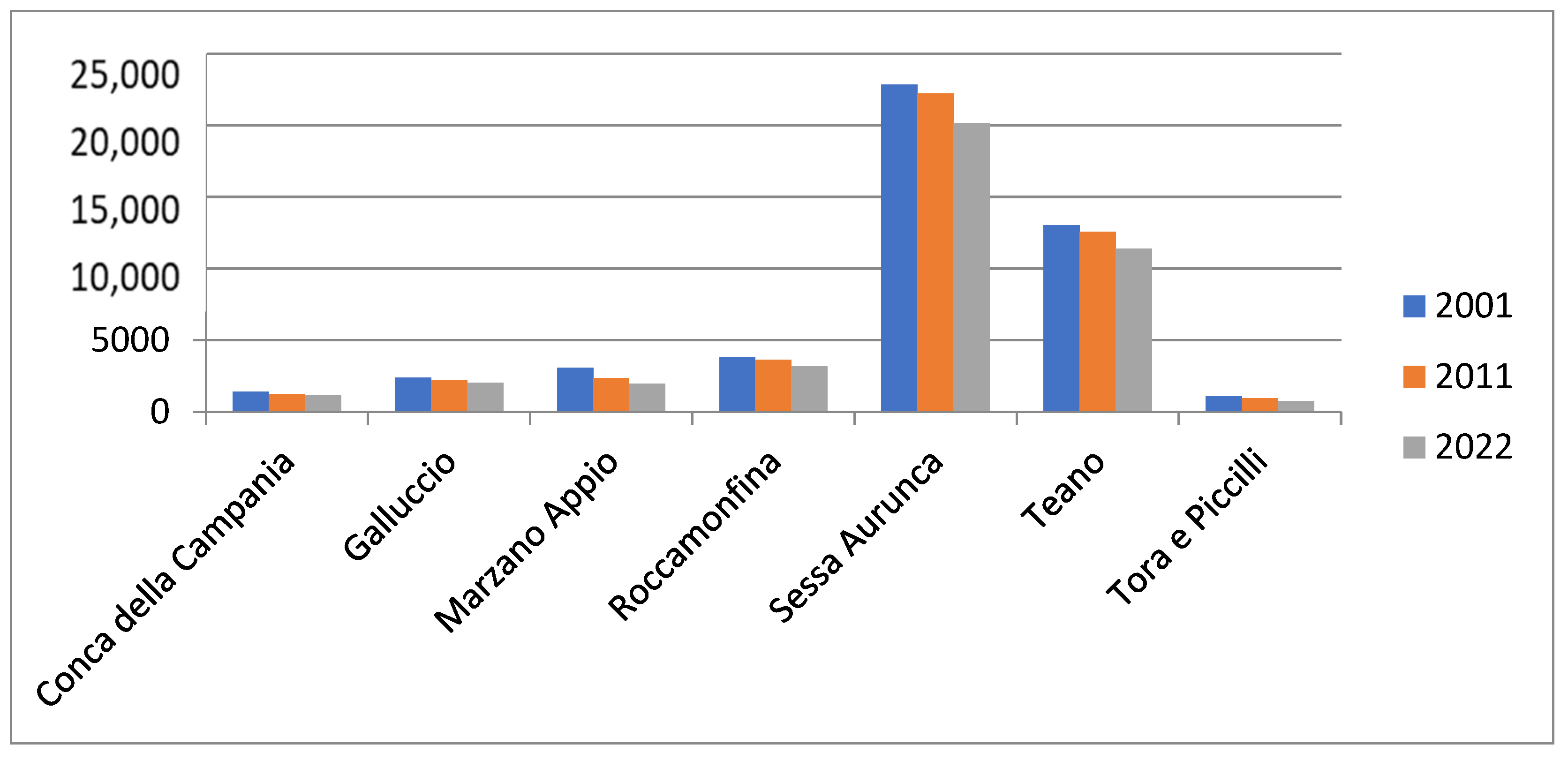
| Totals | 381.97 | 46,234 | 43,960 | −2274 | −4.92 | 39,490 | −4470 | −10.17 |
| Strengths | Weaknesses |
| Botanical characteristics, fauna, geological, volcanic agronomic | Depopulation of the centre and the territory |
| Biodiversity | Abandonment of centre facilities |
| Quality agricultural products (chestnuts, wines, annurca apples) Historical centres that preserve important historical-urban and architectural evidence of the past (Traces of the Aurunci people, megalithic walls, castles, the permanence of the urban plan, Roman theatres and amphitheatres, 15th-century noble seat, Sessa Aurunca cathedral, The ‘Devil’s Claw’, fossil human footprints dating back 350,000 years, 16th-century shrine | Reduced accessibility to areas, both vehicularly and remotely (lack of digitization) |
| Chestnut woods | |
| Opportunities | Threats |
| Quality certification of certain products (chestnut, wine, annurca apple) | Hydrogeological instability (due to the reduced presence of people engaged in agricultural activities) |
| Recognition of the area as a natural area to be protected | Decline in construction |
| Mediterranean Diet | Reduction in work possibilities |
| Orange Flags | Isolation from the context |
| Recognition of the Regional Protected Natural Area | Desertification of the centre and the entire area |
Disclaimer/Publisher’s Note: The statements, opinions and data contained in all publications are solely those of the individual author(s) and contributor(s) and not of MDPI and/or the editor(s). MDPI and/or the editor(s) disclaim responsibility for any injury to people or property resulting from any ideas, methods, instructions or products referred to in the content. |
© 2023 by the authors. Licensee MDPI, Basel, Switzerland. This article is an open access article distributed under the terms and conditions of the Creative Commons Attribution (CC BY) license (https://creativecommons.org/licenses/by/4.0/).
Share and Cite
Bertini, A.; Vitolo, T. Historical Centres, Protected Natural Areas, Communities and Sustainable Development: A Possible Balance. Land 2023, 12, 403. https://doi.org/10.3390/land12020403
Bertini A, Vitolo T. Historical Centres, Protected Natural Areas, Communities and Sustainable Development: A Possible Balance. Land. 2023; 12(2):403. https://doi.org/10.3390/land12020403
Chicago/Turabian StyleBertini, Antonio, and Tiziana Vitolo. 2023. "Historical Centres, Protected Natural Areas, Communities and Sustainable Development: A Possible Balance" Land 12, no. 2: 403. https://doi.org/10.3390/land12020403
APA StyleBertini, A., & Vitolo, T. (2023). Historical Centres, Protected Natural Areas, Communities and Sustainable Development: A Possible Balance. Land, 12(2), 403. https://doi.org/10.3390/land12020403