Abstract
The advancement of smart metering technology is progressing steadily and inevitably across various key economic sectors. The utilizatio.n of remote sensors in agriculture presents unique characteristics and specific challenges. In this study, an on-site experiment was carried out on a Slovakian production farm to analyze the transition from traditional measurement methods to smart meters, focusing on timing decisions related to soil preparation and sowing and their relation to scientifically justified dates. Consequently, a clear distinction was observed in terms of the timing decisions made regarding agricultural activities during traditional, combined, and scientifically based approaches in meteorological data readings. This study contrasts these three scenarios and deliberates on the factors that need to be carefully evaluated before incorporating remote sensors into agricultural processes. This study serves as a valuable resource for individuals involved in the adoption of smart metering practices in the Eastern European agricultural sector and promotes an improved understanding of the interactions within smart-sensing, scientific developments, and land management that contribute to the goal of land-system sustainability.
1. Introduction
Between 29 November and 1 December 2022, the global forum and exhibition Enlit Europe 2022 was held in the German city Frankfurt am Main, dedicated to the digitalization of energy systems in global economies, known as “Energy Transition” [1]. The three top low-power wide-area network (LPWAN) technologies competing for widespread IoT implementation [2] were presented at the event: a long-range (LoRa) solution; a NarrowBand-Internet of Things (NB-IoT) solution; and a French global network operator, Sigfox. These LPWAN suppliers provide effective ways to link intelligent, autonomous, and diverse devices. LPWAN is also known as a wireless wide-area network that connects low-bandwidth, battery-operated devices over large distances at low bit rates [3,4]. Smart cities, smart metering, smart lighting, asset monitoring and tracking, precision agriculture, livestock monitoring, energy management, manufacturing, and industrial internet of things (IoT) deployments are just a few of the applications that frequently employ LPWANs. The size of the European LPWAN market exceeded EUR 600 million in 2020, and between 2021 and 2027, it is anticipated to increase by over 60% [5]. Due to the growing use of artificial intelligence (AI) and IoT technologies for the efficient management of agricultural operations, the agriculture sector is expected to report growth of almost 55% between 2023 and 2032 in Europe [6]. The adoption of LoRa and other LPWAN technologies in the agriculture industry will increase as a result of the growing reliance on smart agriculture methods and IoT installations. The lengthy battery life of sensor equipment is crucial in agriculture. Alkalinity, humidity, and temperature sensors have the potential to drastically reduce the consumption of resources such as water, electricity, and engine fuels while increasing yield. Farmers are utilizing these technologies for a range of applications, such as farm tracking, precision agriculture, livestock environment monitoring [7], and crop fields, fish aquaculture, and smart greenhouses, etc. Sigfox and LoRa are especially capable of carrying out such tasks [2]. Recent studies on the future of organic certification emphasize the importance of electronic sensors in detecting and verifying parameters that meet organic standards [8,9].
However, there are some common difficulties that hinder the dynamic development of smart technologies in agricultural practices [10]. One of the major barriers to new integrations is the initial investment in new technology, a problem that is also being addressed by conditional subsidies from governmental entities [11]. The high degree of resistance to remote sensing systems among farmers, especially in light of concerns over data privacy, is a significant problem for the sector [11,12]. Another obvious obstacle, as determined in some of the literature, is that LoRaWAN offers long-range coverage that can only reach around 15 km in rural areas [13,14]. The financial aspect of operations is also mentioned, for example some respondents worry that installing smart meters may raise their operating costs for more accurate readings. On the other hand, some of them could have unreasonable expectations about the savings that remote sensors would provide [15,16].
Based on statistics [17], the western region of Slovakia contributed a major gross crop production turnover of EUR 995.26 mln, which makes up 65.36% of the overall production of EUR 1522.79 mln in 2021. In terms of the utilized land area, the largest territory is occupied by farms with an area of more than 1000 hectares, taking into account their total number, that is, 529 entities, of which a major part, 243, are also located in the western part of the country [17]. In terms of crop type in 2021, the principal agricultural commodities of Slovakia are wheat and oil crops, including sunflower seeds, totaling EUR 372.76 and 360.63 mln, respectively [17]. The EU members forecast an increase in the production of sunflower seeds; in particular, Slovakia estimates that it will increase its production by 10.87% over the next 5 years [18].
The main objective and first research question (RQ1) of this study is: to identify whether there is any difference in the timing decisions concerning tillage and sowing under traditional (TR-type), self-smart measurements (SELF-type) and the scholarly approach (SCHOL-type) in smart measurements in the average crop farm in Slovakia. We propose a preliminary hypothesis that conventional measurement techniques (TR) and autonomous self-assessments (SELF) utilizing smart sensors yield identical results or a negligible difference in terms of operation schedules, while exhibiting variations in the academic approach to timing decisions (SCHOL). A secondary research objective (RQ2) is: if such differences are found, to identify the primary obstacles faced by traditional (TR) and self-measurement (SELF) farms in Slovakia as they shift towards scientifically based timing decisions (SCHOL) in operational practices.
2. Data and Methods
The farm under consideration fundamentally reflects three alternative measurement methods during the transition from the conventional measuring method to smart technologies in our experiment study (Table 1).

Table 1.
Tasks and key methods for defining the current state of and perspectives on smart metering in crop production using the LoRaWAN protocol in western Slovakia.
- Prior to the experiment, the farm utilized traditional or classical measurement techniques based on its own knowledge (TR-type);
- Independent smart measures or self-measurements based on its own knowledge (SELF-type), as defined by Questionnaire 2;
- Scholarly smart measurements (SCHOL-type) based on knowledge of the literature.
The experiment study was carried out by performing the following key tasks, using the relevant methods presented in Table 1.
2.1. Experiment Criteria
For the purposes of the experiment study, the aim was to conduct an investigation on the basis of an agricultural entity which satisfied the following representative criteria:
- (1)
- It is located in the part of the country where the largest gross turnover of agricultural commodities is achieved;
- (2)
- At the same time, the main crop of production should occupy the largest share in the structure of gross turnover according to national statistics;
- (3)
- The size of the agricultural producer concerned should correspond to the size category of farms with the largest cultivated land (ha) in the country;
- (4)
- To ensure a complete transition to smart metering from scratch, the farm should not have previously used wireless communication technologies and digital sensors to collect meteorological data.
Criteria 1–4 are intended to ensure the highest possible level of representativeness among those holdings that contribute the most to gross national income and cover the largest share of agricultural land. The exact test location for setting the measuring sensors should also take into account criteria 5–9, namely:
- (5)
- The sensors should be installed in an open field where crops will be grown in 2023;
- (6)
- The installation point must be set in close proximity to the growth of the crops, in order to read the current physico-climatic data affecting their growth;
- (7)
- The installed station must catch a stable regular signal every 60 min in the coverage area of the LoRaWAN network;
- (8)
- The installation site of the sensors should be relatively secure from theft and acts of vandalism;
- (9)
- The planned period for the measurement phase of the meteorological parameters in the open field of the chosen farm is 3 calendar months from 1 March 2023 to 31 May 2023, or 92 days.
This calendar period in the spring season (criterion 9) is the most energy-intensive in terms of the production cycle of the main crop commodities, since it includes the most expensive operational procedures, such as tilling, sowing, cultivation, and applying spring fertilizers, as well as measures for protecting crops from diseases and pests.
2.2. The Farm
According to criteria 1–3 for the experiment study, the agricultural cooperative (AC) Kuty (Poľnohospodárske družstvo Kuty (PD Kuty)) was chosen, which is located near the village of Kuty, in the Trnava region in western Slovakia. Based on the business register [19], the main focus of the cooperative’s activity has been agricultural production since 13 September 1991 [19]. A request was sent to the farm with an offer to participate in the experiment for research purposes, which was later accepted. AC Kuty created a subsidiary company, FACH feeder, s. r. o., of which AC Kuty is a 100% owner. Jointly, they occupy more than 1000 ha of agricultural land in the cadaster of villages Kúty, Kuklov, and Borský Svätý Jur, in the Trnava region [20]. Field measurements were carried out on a soil classified by the WRB [21] as Eutri-Protic Arenosols, associated with Eutri-Arenic Cambisols, locally in the Arenic Gleysols depressions; it is formed from non-carbonate wind-blown and redeposited sands. Sunflower seeds were grown here throughout most of 2023. The characteristics of the soil, based on MKSP (2000) [22], are as follows: The soil type is D1 (ID201); the dominant ground units are regozemes modal and cultismic silicate light, accompanying cambism modal and cultismic saturated light, locally, in depressions, light gleys; from non-carbonate soft and flooded sands. The characteristics, based on PM SR (2024) [23], are: Soils with an ochric A horizon, in places with even hints of a Cambic Bv horizon; deep; light in terms of grain size; with an acidic soil reaction; and permeable to water. The uses of the soil and primary crops are for arable soils (cereals, corn), permanent grasslands, and forest soils. The limiting factors affecting the soil fertility are: high permeability of the water; low soil reaction; content of the accessible nutrients; and a lack of moisture. The potential degradation processes are wind erosion and acidification.
The farm operates with conventional tillage under the rules and principles of organic farming. The actual operation management does not involve fertilization, extra irrigation, or pesticide spraying. According to [24], the overall growth of the observed sunflowers on the farm’s field reached stage V12 by the end of the measuring time on 31 May, with the growing degree days (GDD) equaling 627 units and a total of 31 days of growth [24]. The total cultivation area of the sunflowers on the farm in 2023 was 630 ha.
2.3. Quantitative and Qualitative Data
2.3.1. In-Depth Interview 1: Before the Test
The aim of the first interview was to confirm the previously collected information about the farm, as well as to ensure that criteria 1–4 were met for this experiment. Subsequently, the interview was designed to collect qualitative data, such as the analysis of the costs for the initial installation of the equipment and the operating costs, as well as to determine the prospects, causes, and level of awareness regarding LPWAN technologies by decision-makers on the farm. The questionnaire designed for in-depth interview 1 before the test was suggested for a reply. The answers to the questions were recorded in voice form using an audio recording device. The voice sequence will be digitally recorded and stored in mp3 format for its subsequent manual transcription into digital text as doc-file.
2.3.2. On-Site Measurements, Data Specification, and Communication
The measurement test was designed to reveal the strengths and weaknesses of the use of the LoRaWAN communication protocol in the daily operations of the selected agro-holding, which does not use such or similar technologies. Furthermore, real economic justifications for the further distribution or obstacles for the development of the suggested technology in similar conditions are determined. The main condition for conducting a metering test in the open crop field is in compliance with criteria 5–10.
The following parameters are divided into three categories: A, B, and C:
- Basic meteorological parameters (A) from special sensors: Category A includes the parameters of air temperature [TA, °C], the relative humidity of the air [HR, %], solar radiation [SR, W·m−2], precipitations [P, mm], wind speed [vw, m·s−1] and wind gust speed [vg, m·s−1], soil temperature [TS, °C], and soil moisture [HS, %];
- Virtual parameters or auto-calculated values (B) out of initial parameters: Category B, concerning dependent values, contains factors such as dry-bulb air temperature [TDB, °C], wet-bulb temperature [TWB, °C], due point [TDP, °C], vapor pressure deficit [VPD, kPa], and Delta T [TΔ, °C];
- Internal operating parameters (C) ensuring the autonomy of the meteorological station: Accordingly, category C includes sensors that ensure the continuous, autonomous operation of the entire measurement complex, namely: the battery charge [CB, mV] and solar panel charge in voltage values [CSP, mV].
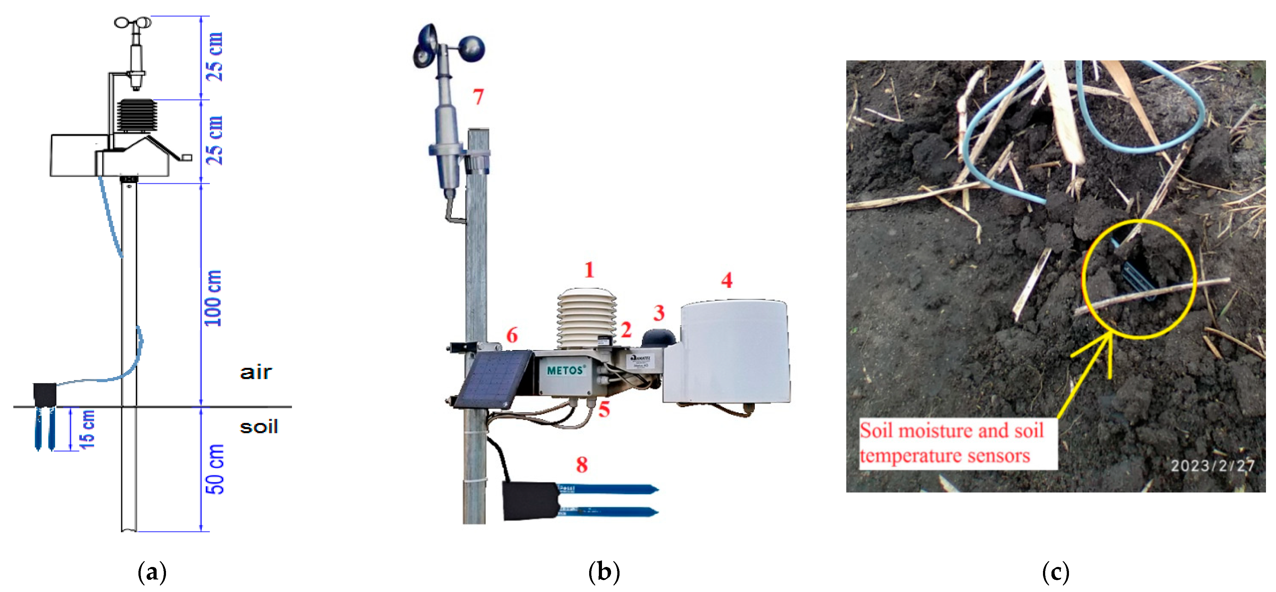
To collect the above data, we used the definite prefabricated meteorological station iMETOS 3.3 by Austrian manufacturer Pessl Instruments GmbH with a LoRaWAN® connectivity module (Figure 1a). The operating range of iMETOS is between −35 °C and 80 °C. The installation of the weather station on a crop field for the purposes of the experiment case is based on the scheme depicted in the Fieldclimate.com portal. The identification name of the experiment station is 0320D1C2.
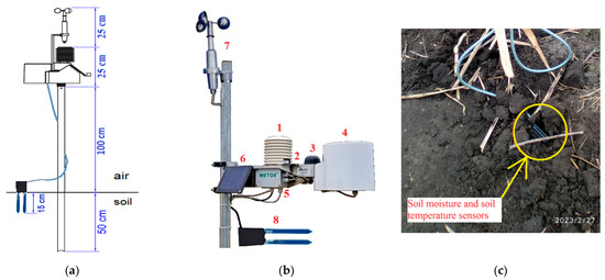
Figure 1.
(a–c): Schematic (a) and visual view (b,c) of the iMETOS 3.3 station 0320D1C2 on the settlement. Legend (b): (1) Temperature and relative humidity sensor; (2). Global radiation sensor; (3) Antenna; (4) Rain gauge; (5) Logger and modem; (6) Power supply (solar panel and battery); (7) Wind speed sensor; (8) and (c) Temperature and soil moisture sensors. Source: Developed by the authors.
Specifications of the measuring station set for the initial meteorological parameters (A parameters):
- Participation sensor Pessl Instruments Rain Gauge (Figure 1(4)): The resolution, with a surface of 200 cm, is 0.2 mm, while the resolution with a surface of 80 cm is 0.5 mm. The sensitivity is 1 tip per 0.2 mm or 1 tip per 0.5 mm; the maximum rain is 12 mm/min; the accuracy is ±5%; the measurements are 185 mm diameter × 250 mm height.
- Air temperature and relative humidity sensor (Figure 1(1)): Sensor HYT221 is sensitive to electromagnetic waves. The operating temperature range is −40 °C to +125 °C. The humidity range is 0% to 100% RH. The accuracy is ±0.2 °C (0 °C to +60 °C) or ±2% RH at +23 °C (0% to 90% RH). The operating voltage is 2.7 V to 5.5 V. Digital interface I2C, address 0 × 28 or alternative address. The operating voltage (limit data) is 0.3 V to +6 V. The storage conditions are −20 °C to +50 °C.
- Pyranometer IM506D is designed for field measurements of global solar radiation (Figure 1(2)). Calibration against Kipp and Zonen CMP3 under daylight. Absolute error—max. 5%, typically 3%; Time to measure—10 µs; Temperature dependency—0.15% per °C. Correction—sensor corrects up to 80° degrees of cosines. Azimuth is 1% error over 360 degrees at a 45-degree elevation. The operating temperature range is −20 °C to 65 °C. The operating relative humidity range is—0 to 100%. Photodiode sensor—LI-200SZ; Weatherproof PAS case with acrylic diffuser, stainless steel hardware. Size—35 mm diameter, 45 mm height; Evaluation—Pulse Wide Modulation 0–80% = 0–2000 W·m−2. The spectral range is between 300 and 1100 nm.
- The IM512CD wind speed sensor (Figure 1(7)) is a cup type anemometer for long-term accurate wind measurements. It calculates the average wind speed in a given period of time. The speed range is 0 to 50 m/s; gust survival is 60 m/s. It has a 12-cm diameter cup wheel assembly; 40-mm diameter hemispherical cups. AC sine wave signal induced by rotating magnet on cup wheel shaft: 100 mVpp at 60 rpm; 6 Vpp at 3600 rpm. The output frequency is 1 cycle per cup wheel revolution; 0.75 m·s−1 per Hz.
- Soil Moisture and Soil Temperature Sensors PI54-D (Figure 1(8)): determine the volumetric water content (VWC) by measuring the dielectric constant of the soil using capacitance technology and soil temperature. They are 10 cm long and thus measure 1 L of soil. High-frequency minimizes salinity and textural effects. Range: 0–0.57 m3/m3 (0–57% VWC). Resolution: 0.0008 m3/m3 (0.08% VWC), in mineral soils from 0 to 0.50 m3/m3 (0–50% VWC). Accuracy: with standard calibration equation, 0.03 m3·m−3 (3% VWC) is typical in mineral soils that have solution electrical conductivity < 10 dS/m. With soil-specific calibration, ±0.02 m3·m−3 (±2% VWC) is typical in any soil. Dimensions: 16.0 cm (6.3 in) length; 3.3 cm (1.3 in) width; and 0.8 cm (0.3 in) height. Prong length: 10 cm. Operating temperature range −40 to 50 °C. Cable length: 5 m. Supply voltage (VIN to ground-GND) min: 3.6 Volt Direct Current (VDC) at 12 mA, max.: 15 VDC at 20 mA. Measurement duration < 10 ms, soil temperature [Ts, °C] accuracy ±0.3 °C.
Virtual indicators include such automatically defined parameters of category B as:
- The vapor pressure deficit (VPD) is a value measured in kPa by default and derived from the relative humidity and air temperature and is closely related to evapotranspiration. The value is automatically calculated using the following formula:where: SVP is the saturated vapor pressure or vapor pressure at air temperature; AVP is the actual vapor pressure or vapor pressure at dew-point temperature; and RH is the relative humidity of air in % [25].
- Dew point [TDP, °C] is the temperature where the air is saturated with water vapor. The air’s water vapor is in equilibrium with liquid water when it reaches the dew-point temperature and pressure, which means it is condensing at the same rate as liquid water is evaporating. The value is virtually estimated as:where T is the observed temperature in degrees Celsius [26].
- Delta T [TΔ, °C] is a measurement that accounts for the combined effects of temperature and humidity and indicates whether the weather is right for spraying in order to get the most out of the pesticides. This is an indicator of the rate at which pesticide droplets evaporate and combines the effects of temperature and relative humidity [27]. The value is self-defined as:where TWB is the wet-bulb temperature in °C, and TDB is the dry-bulb temperature in °C.
- Evapotranspiration [ET0, mm] is calculated with the FAO-56 Penman-Monteith Equation (4) [28] and using atmospheric demand; it tells us how much water the plant needs each day to grow. This water originates from precipitation or soil moisture in the root zone. A crop can need from 7 to 9 mm of water on an average hot day. It may receive 30 to 50 mm of water in a week. This enables us to schedule the amount of potential water needed to sustain crop health and productivity.where ET0 is the reference evapotranspiration [mm day−1], Rn is the net radiation at the crop surface [MJ m−2 day−1], G is the soil heat flux density [MJ m−2 day−1], T is the mean daily air temperature [°C], u2 is the wind speed [m s−1], es is the saturation vapor pressure [kPa], ea is the actual vapor pressure [kPa], slope vapor pressure curve [kPa °C−1], and γ is the psychrometric constant of 0.054 [kPa °C−1].
The internal operating parameters (C) are set by default in the iMETOS 3.3 station. They appear in a connected rechargeable battery (Figure 1(5)) with a supercapacitor with a minimum voltage > 6 V as CB in [mV], 4.5 Ah, which collects energy from the connected solar panel (Figure 1(6)) in a voltage value of CSP [mV] with the dimensions 13.5 × 13.5 cm and a performance of 2 Watt. This combination of devices makes it possible to constantly recharge the lost battery power spent on measuring and logging sensor data before transmitting them to cloud storage.
The station uses the LPWAN network to transmit data over a distance with an HL7802 LPWA Module and micro-SIM card for Cat-M1/NB1 worldwide networks such as LoRaWAN. The transmitter has frequency bands B1–B28, B66 and a peak download/upload rate of Cat-M 300/375 Kbps and is capable of providing a low-cost technology solution for low-bandwidth IoT applications with extended reach beyond traditional cellular limits. To mitigate connectivity issues, the station stores data from the last 2–3 days internally and resends the measured values to the cloud platform FieldClimate when the connection becomes available again. The iMETOS 3.3 can read parameters A–C with an interval of 5 min, to log the data each 15 min and synchronize them with the monitoring web server with the transmission frequency of each 60 min. The METOS weather station is a LoRaWAN® end-node device that interacts with the LoRa® gateway, the station that transfers data to the internet. The gateway forwards the data to the network server, which then pushes the information to the app platform [29].
FieldClimate (https://fieldclimate.com/login, accessed on 5 September 2024) is the cloud platform used to present agrometeorological data collected by the METOS® weather station and data loggers. After registering the station ID number, the data become available for online monitoring, alert configurations, downloading the data in xls-format and frequency settings for recording, logging, and transmitting.
2.3.3. Survey on Potential Changes in Farm Operations
The survey is conducted in 2 consecutive questionnaires, numbered 1 and 2. The first part involves the preliminary completion of the form on facts relating to basic work carried out on the farm between 1 March and 31 May of 2023. In particular, this includes dates and features of the main agricultural operations, such as: soil preparation (i.e., tillage), sowing, irrigation, and plant protection. In the second survey, the authors combine the data collected with smart sensors from a field of sunflower cultivation with a total area of 630 ha between 1 March 2023–31 May 2023 with plotted questionnaire 1 also sent to the technical engineer of the farm. The following question needed to be answered: If you knew these climate parameters and indices in advance, for example thanks to an advanced forecasting system, would you change any of the following?
- o
- The time of the performed operations 1–5?
- o
- The structure or frequency of such operations?
The answers to these surveys will allow us to respond to RQ1: does the ability to monitor climate data in an open growing field affect farmers’ decisions about the timing, quality, and quantity of agricultural operations in the field?
2.3.4. In-Depth Interview 2: Probability and Conditions for Changes in Operations
A comprehensive interview was conducted with a technical employee and a farm manager to gather their views on the impact of smart data from the field on agricultural operations. While we have considered the existing literature on these effects, we aim to compare their insights with established theories to explore any discrepancies. This analysis may enhance our understanding of the challenges involved in applying this technology and provide an initial assessment of its potential benefits and drawbacks.
Two separate interviews based on identical questions conducted with a technical engineer and a farm manager were designed to ensure the maximum degree of objectivity in the information provided. Information obtained from two sources belonging to one entity, united by a common goal, is intended to be complementary and not contradictory. The influence of subjective influence in this case is thus limited.
Based on the literature analysis, we will try to justify the change in some operations on the field. Thus, in search of an answer to RQ2: How exactly do predictive meteorological data and scholarly reviews influence a farmer’s acceptance of the schedule and nature of operations in his farming activity? During Interview 2, the farmers are provided with a different, possibly more efficient operation time based on data collected in the open field. We evaluate the effectiveness of the learning framework in incentivizing farmers to improve their practices. Farmers often rely on intuition to assess soil suitability for ploughing and seedbed preparation, but these methods are subjective and can be inaccurate [30,31].
3. Results
3.1. Pre-Field In-Depth Interview 1
The results of the first interview confirm the farm’s necessary criteria 1–4 for conducting the planned experiment. In particular, the respondent to the first in-depth interview confirmed the location (by criterion 1): the Kúty and Borský Svätý Jur area in the Trnava region. Regarding the main production crops and their structure (criterion 2), the respondent gave the following extended comment: “We have a mixed organic farm with plants (winter wheat, durum and spelled wheat, sunflower, rye, winter barley, spring barley, oats, peas, fluff, as well as mixed crops for animal production/oats with peas under seeding, and in recent years we have returned to growing silage corn for cattle), that is, approximately 70% of the production is taken up by plant production, and the remaining 30% by animal production (cows, pigs, chickens)”. Regarding the total area of production of the farm (criterion 3), the respondent’s extended response was as follows: “More than 1000 ha, approximately 1450 ha in total together with a subsidiary”. It was also confirmed that the enterprise does not belong to anyone that uses remote or network methods for measuring climatic parameters at production sites (criterion 4). On this, the respondent gave the following extended answer: “During production, we only use classic hand-held meters, a rain gauge, and we write down the approximate night or morning temperature. The lowest and when it is the highest during the day, so we don’t have any special instruments. We measure it every day, i.e., the precipitation, we try to write it down every day, then we make a monthly summary at the end of which we evaluate how much precipitation there was, whether it was an average, below-average, or above-average precipitation year. We currently only have one rain gauge in the yard. In the near future, we would like to start using rain gauges on certain parcels to see where and how much it has rained and to be able to adapt the technological methods of tillage accordingly”. The respondent’s answers were translated into English from the original Slovak language. The respondent also indicated that this is a fairly well proven measurement method, and it is also low-budget. For example, although they try to change the classic rain gauge every year, it costs about 5 EUR and there is little working time to install it. They spend about 5 min obtaining each individual measurement; per month, this amounts to 3 h of labor time. Considering an income rate of approximately 5 EUR per hour, this totals about 15 EUR per month only. They did not consider switching to remote sensing because did not know anything about it before. In response to the question “What do you think about the possibilities of using such a system on your farm?”, which was asked at the very beginning of the experiment, they made the following comment: “After clarifying the functioning of the system, I think that theoretically we could use this system in more distant fields where we cannot practically measure precipitation or soil temperature. We would also be able to evaluate what the month was like in terms of temperature, precipitation (a below-average, average, or above-average amount of precipitation) and what the temperature of the soil was at the time of the field work, and we would know more precisely when the soil needs to be prepared for sowing crops. Due to the fact that we have different types of soil, ranging from light sandy to clay soils, not everywhere can be reached with the same amount of precipitation on the same date. Sandy soils absorb water immediately and it is more likely that, for example, with a total of 5 mm of rainfall, it will be possible to enter the field with equipment the next day, with clayey soils, with the same total of rainfall. There is a delay in entering the field of two days. At this point, the system could potentially be beneficial for our farm”.
3.2. Remote Sensor Installation
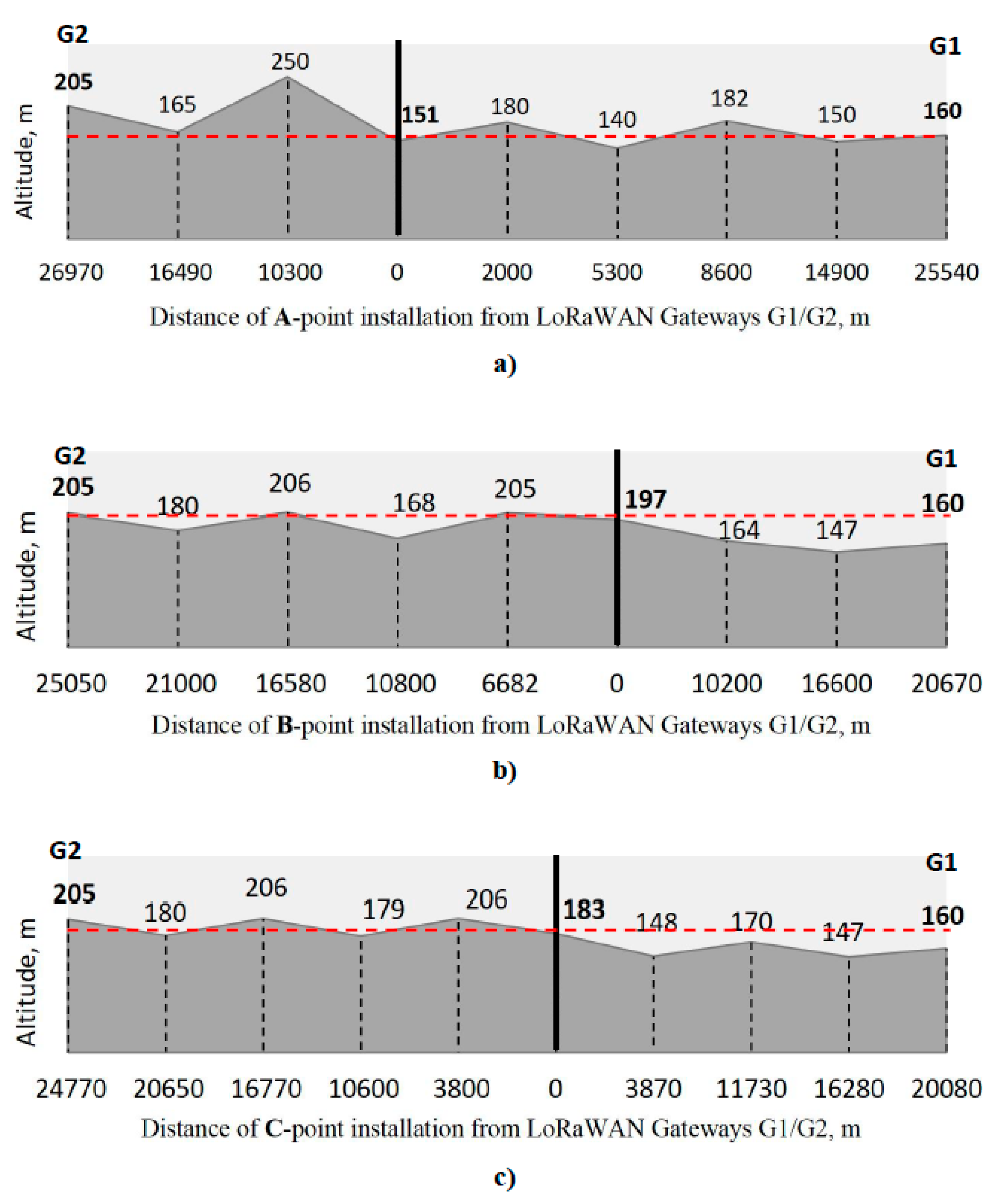
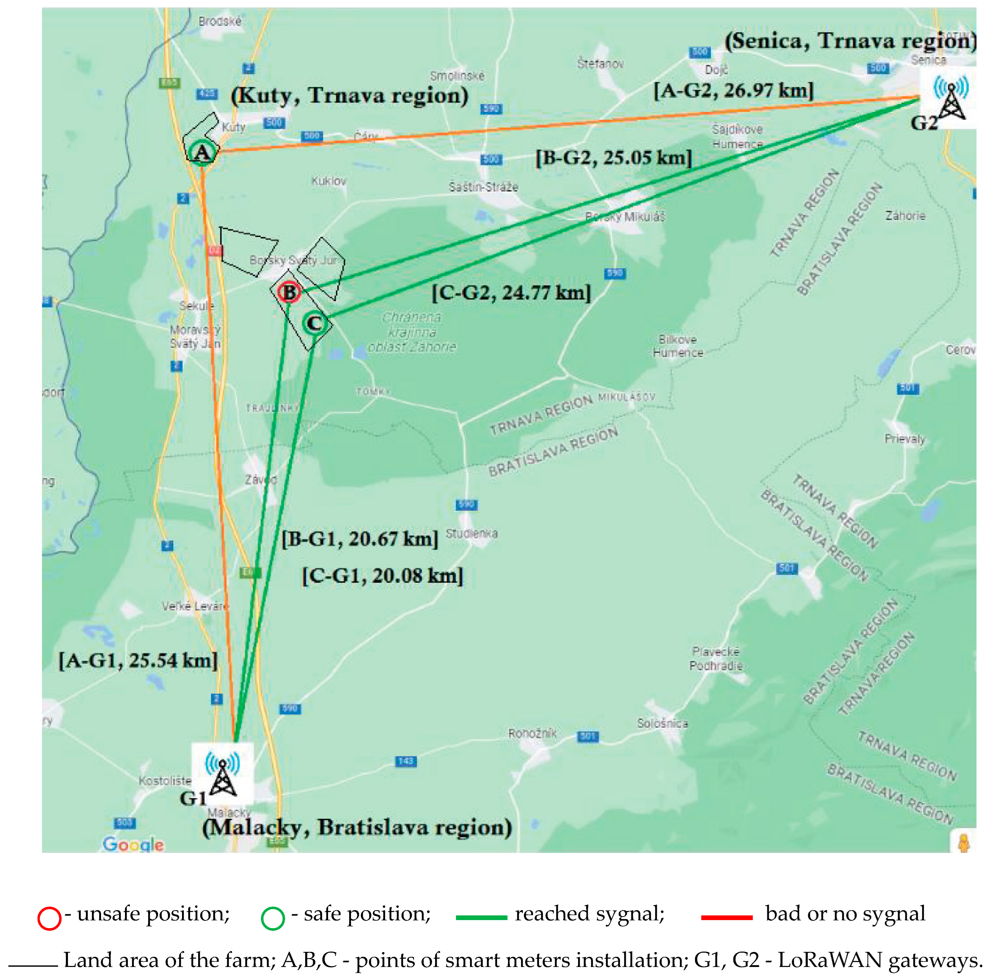
On 27 February 2023, the first installation of the meteorological station (Figure 2a), Figure 3: Point A was made at the logistically feasible and closest wheat-growing point to the farm’s administrative building, meeting the experiment condition criteria 5, 6, and 8. The reach of the signal needed to be determined at the installation site (criterion 7). Based on the World Geodetic System 1984 (WGS84), in degrees, minutes, and seconds format (DMS), the latitude and longitude coordinates of the sensors are 48°38′52″ N 17°00′13″ E, with an altitude above sea level of 151 m (Figure 2a and Figure 3: point A). What is near the Kuty settlement. According to the network provider Slovanet a.s., the nearest LoRaWAN gateways G1 and G2 in this region are set in the following coordinates: 48°26′41″ N 17°01′26″ E in Malacky (G1) at a 160-m altitude above sea level and 48°40′51″ N 17°21′52″ E in Senica (G2) with a 205-m altitude, respectively (Figure 2a–c and Figure 3). This makes the distances from the established station 25.54 and 26.97 km, respectively. Based on the provider’s information, the range of a transmission varies greatly. Typically, signal quality must be measured directly in the field. It is also affected by the kind of antenna used and the size of the data message to be sent (payload). In reality, if the device is located on a hill and there are no impediments, messages can be delivered up to 50 km. Nevertheless, even 10 km from the gate may not be sufficient. However, in our case, the signal was not sent from the station working properly within 24 h. This tells about the inaccessibility of the ultrasonic signal under given conditions, taking into account the distance, relief, structure of the terrain, and climatic conditions. In support, based on Figure 2a, the altitude level of A-point installation of smart meters was lower than receiving gateways G1 and G2 by 9 and 54 m, respectively. Moreover, there are even higher hills on the way of signal transmission, reaching a height of 182 and 250 m. In this regard, the installation of the station was moved to another open field location belonging to the farm, south of the village of Borský Svätý Jur (Figure 2b) (Slovakia) and Figure 2b. It was installed in the coordinates of 48°36′08″ N 17°02′45″ E on a hilly terrain to increase the likelihood of signal reach with an altitude level above the sea of 197 m. The air distances to gateways G1 and G2 then become 20.67 and 25.05 km, respectively.
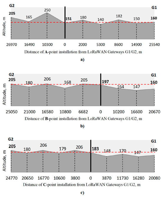
Figure 2.
(a–c): Landscape altitude [m] above sea level between Gateways at installation points. Source: Developed by the authors using Google Earth data.
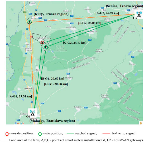
Figure 3.
Schematic representation of three installation locations of sensors and distances to transmitting stations. Source: Developed by the authors using Google Earth data.
The signal began to be transmitted at this location and met criteria 5–7. It supports the altitude levels (Figure 2b), while the second installation did not meet the landscape barriers towards the LoRaWAN gateway in Malacky (G1) (Slovakia) and was 37 m higher above sea level. However, after consulting with the farm’s tractor operator, the installation had to be dismantled due to the higher risk of theft or damage of the meteorological station (failure of criterion 8). This was because the installation site was located near the intersection of a relatively busy roads. Therefore, the station was re-installed on a relatively safe, visually controlled section of the field (Figure 2c), Figure 3: point C meeting criteria 5, 6, and 8 at the coordinates 48°35′46″ N 17°02′54″ E at an altitude of 183 m above sea level. The station successfully transmitted the signal, respecting criterion 7, and the distances to gateways G1 and G2 were 20.08 km and 24.77 km, respectively. In addition, the installation of point C did not encounter any natural barriers in the direction of station G1 and was also higher in general by 23 m above sea level. Thus, data began to be collected on the afternoon of 28 February 2023. However, in the experiment, we took into account the planned data period from the following day, namely, 1 March, at 00:00 h.
3.3. Data Collected with Fact TR- and SELF-Timing Decisions
The climate data collected from the iMethos 3.3 station are summarized in Table 2 by daily average or minimax range values. The results of questionnaires 1 and 2 are also marked with a background color in the table.

Table 2.
Environment data gained on the open crop field during a 92-day test in the Borsky Svaty Jur area in Slovakia.
3.4. Timing Decisions for SCHOL Approaches
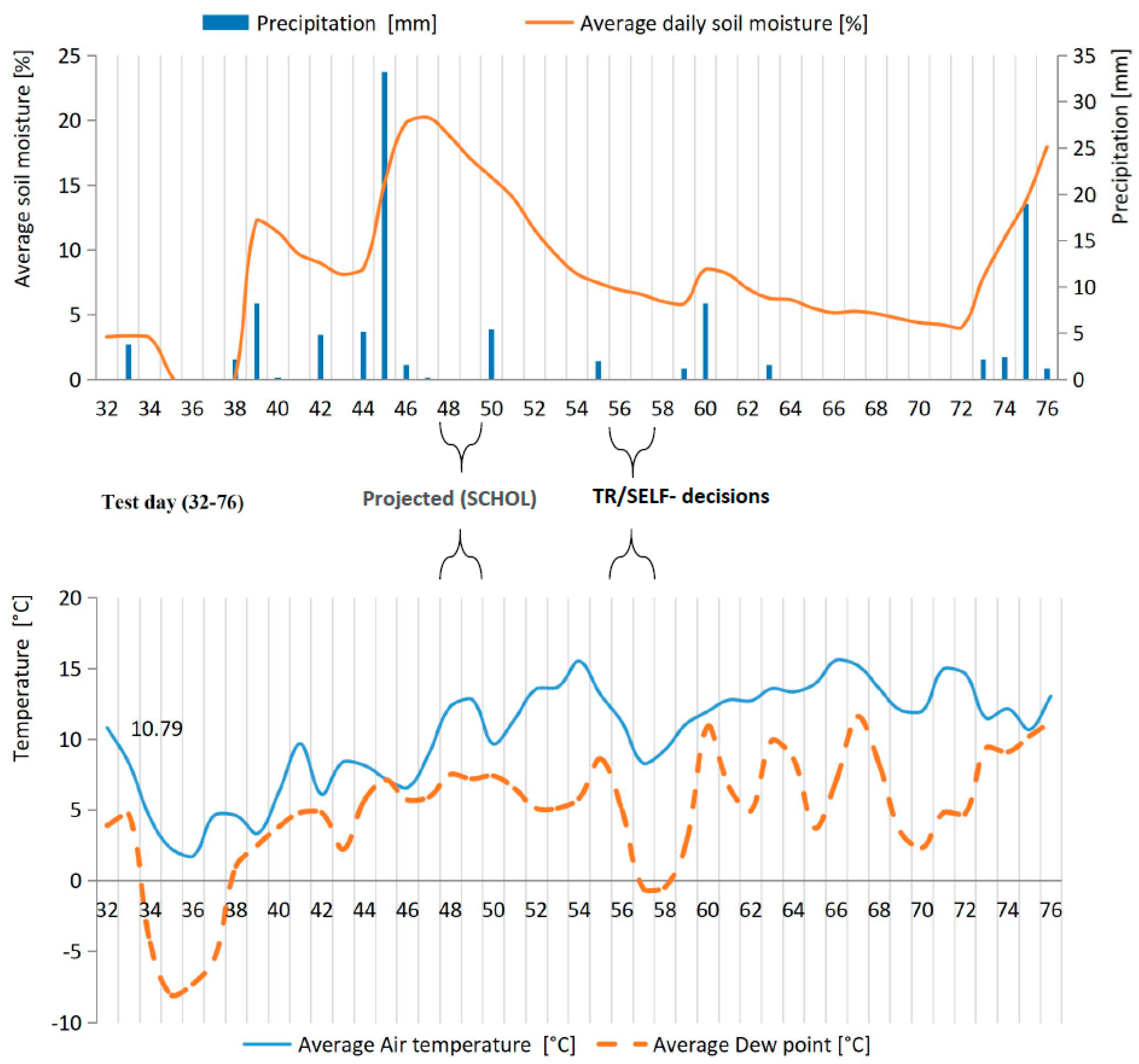
Based on the literature, the SCHOL timing choice would apply for soil preparation in operation 2, as case 1 for SCHOL, if these data were known in advance. In particular, the first projection is to move operation 2 of soil preparation from test days 56 and 57 (25–26 April 2023) to test days 48 and 49 (17–18 April 2023), which is 8 days earlier (Table 2, Figure 4). It is also worth mentioning that, based on data from interview, previously, the only a compact disc harrow (Lemken Rubin 9/600 KUA) worked by breaking up and mixing soil at a depth of approx. 4–5 cm in the middle of October 2022.
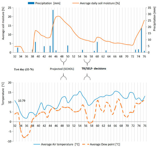
Figure 4.
Possible timing change for soil preparation (operation 2) during smart-metering test on the field within days 32 (1 April 2023)–76 (15 May 2023) (data loaded from the fieldclimate.com portal, generated from experiment station 0320D1C2).
The following factors may justify an 8-day change in the land cultivation schedule (Case 1):
- Absence of precipitation on these days.
- More favorable soil moisture, which is slightly above 15%, for soil characteristics and fuel efficiency at the same ploughing depth [32,33,34,35,36,37]. For example, Ojeniyi and Dexter (1979) [38] stated that the greatest total macro porosity in soil was produced in the range of a 12.6 to 18.3% volumetric water content (%). In some cases, the optimum range of soil moisture for effective ploughing is between 25 and 50% [39].
- Higher dew points likely prevent a quicker depletion of soil water storage, as well as an increase in evaporation following spring ploughing, which might last for several weeks [40,41].
- Higher air temperature has the least impact on processing quality, but it might indirectly decrease the operation’s economics owing to the climatic comfort of operators.
Based on personal Interview 2, we collected the following comments concerning the farming responsibilities in relation to theoretic changes for case 1. An extended comment was received from the farm’s representative: “So it was possible to do it earlier. Since there was no precipitation and the field was ready, it could be done only a few days earlier. Specifically, the shift is 8 days earlier. I think it shouldn’t be a problem.”
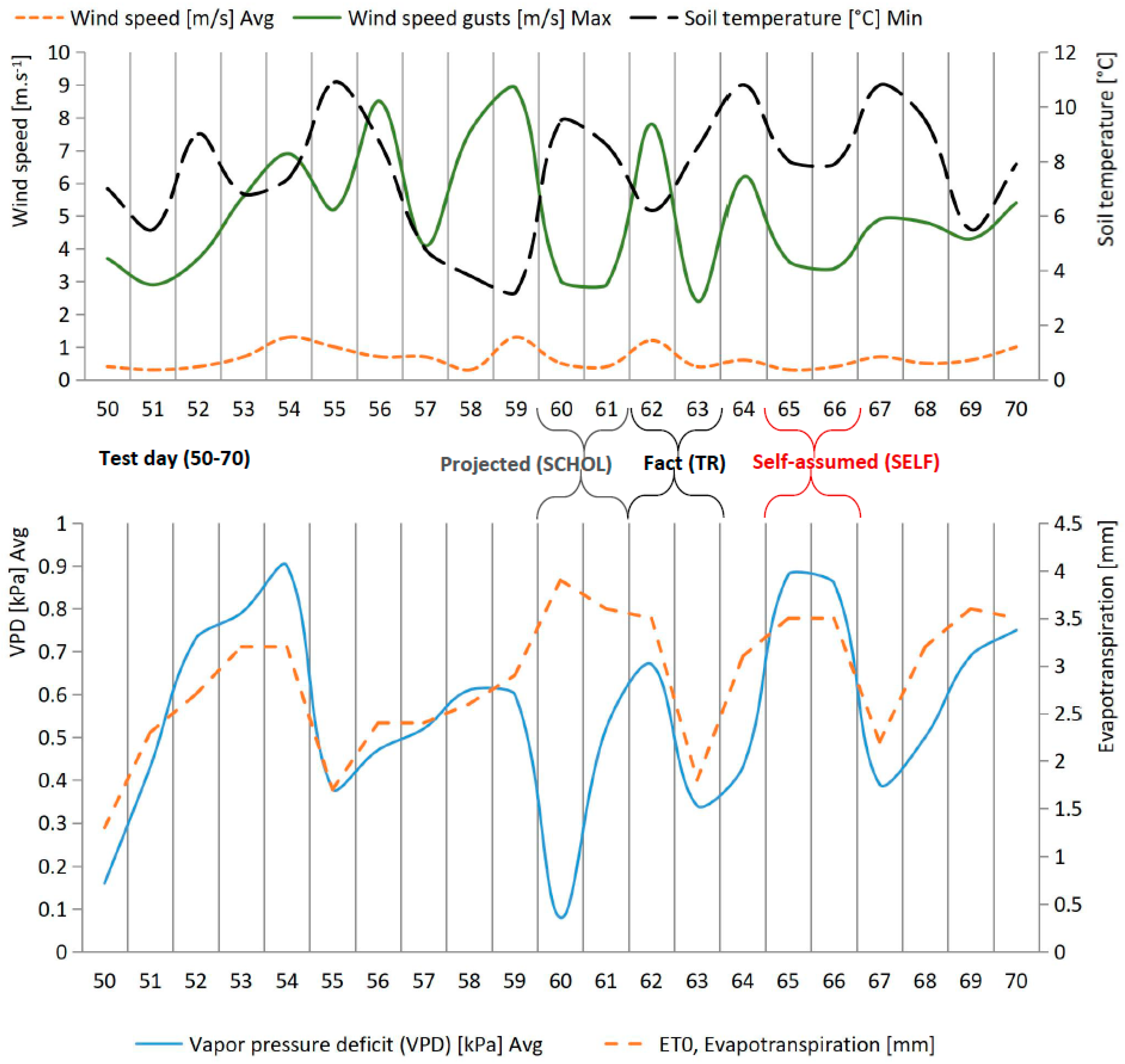
Also, an opportunity was noted for changes to operation 3 as per case 2 according to the SCHOL approach. A feasible alternative planting schedule for sunflower seeds was discovered, which was to move it two days earlier from test days 62–63 (1 May–2 May 2023) to days 60–61 (29 April–30 April 2023) (Figure 5). However, the farm’s technical engineer placed the planting time later (SELF), at +3 days, during days 65–66 (4 May–5 May 2023), according to remote questionnaires 2 and 3.
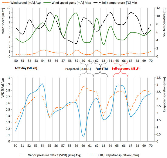
Figure 5.
Factual, self-assumed, and projected time of sowing (operation 3) during smart-metering test within days 50–70 (data loaded from the Fieldclimate.com portal, generated from experiment station 0320D1C2).
Some studies in this area may conceivably persuade the farm to shift the planting activity forward to two days earlier (Case 2). In particular:
- The average wind speed on the first design day of sowing is slightly lower at 1.9 m·s−1, though the actual first day is still not critical at 4.1 m·s−1. However, in the maximum wind gusts, the difference between 3 and 7.8 m·s−1 is already significant, which theoretically could have affected the seed placement quality [42].
- The average soil moisture in the design 2-day period is 8.32% (days 60–61 (29–30 April)). However, in the actual pair (days 62–63, 1–2 May), it is 6.62% (Figure 5). These statistics are also higher in the project period over the next two days, at 6.62 and 5.83%, respectively. This is possibly due to more abundant precipitation over the project time, 8.2 and 1.6 mm, respectively (Figure 5, days 60 and 63 (29 April–2 May). Sunflower seeds require a lot of water to germinate since they contain a lot of natural oil. Wetter soil is desirable for young seedlings in the early days of planting [43].
- The average soil temperature for seeded plants is a critical indication. Although it was somewhat lower during the project time and amounted to 13.05 °C compared to the actual period of 14.35 °C, the minimum attainable soil temperature in the actual period decreased by 2.4 °C, from 8.6 to 6.2 °C, respectively (Figure 5), which could potentially contribute to a bigger percentage loss or damage of seeds [42,44].
- The vapor pressure deficit (VPD) is more indicative than temperature and humidity when studied separately because it takes into consideration the link between air temperature and relative humidity [45,46]. Transpiration occurs when the water pressure in plant leaves is greater than the air vapor pressure. Young plants with short root systems, such as freshly rooted cuttings or recently born seedlings, should have minimum transpiration and should be maintained at a low VPD < 0.8 kPa [47,48]. In the seeding dates, this figure fluctuates between 0.67 and 0.34 kPa, while in the projected figures, this measures within 0.52 and 0.08 kPa (Figure 5). VPD indicates precisely how atmospheric conditions impact plants’ ability to absorb and transpire water. A higher VPD may increase plant dryness, whereas a lower VPD causes disease issues.
- Evapotranspiration increases from establishment to blooming and can reach 12 or 15 mm·day−1. Higher evapotranspiration rates are advised during seed establishment and in the early ripening stage [49,50,51]. The evapotranspiration rates are somewhat higher than the actual rate during the project time, equaling 3.9–3.6 kPa and 3.5–1.8 kPa, respectively.
Therefore, when addressing RQ1, it becomes evident that the three approaches (TR, SELF, and SCHOL) utilized for assessing and interpreting meteorological information do not hold the same value in relation to the timing of key agricultural activities, including soil preparation before sowing and the actual sowing process. In particular, operations 2, 3, and 4 under the TR-type category were, in practice, carried out on days 56–57 (25–26 April), 62–63 (1–2 May), and 67 (6 May). However, if the SELF method were to be implemented, these same operations would be scheduled on days 56–57, 65–66, and 69, respectively. Simultaneously, considering the SCHOL method, it would be logical to execute operation 2 on days 48 and 49 (17–18 April), and operation 3 on days 60 and 61 (29–30 April), while maintaining the date of operation 4 (day 67, (6 May)) exactly as TR.
Based on the analysis of the qualitative information, the main challenges for RQ2 are identified as follows:
- It was evident that the utmost precision in the scheduling of suggested agricultural activities was not expected. Instead, the emphasis was placed on the significance of meeting crucial deadlines. The primary objective is not merely to enhance the efficiency of sowing, but rather to ensure that it is not compromised in any way.
- The effectiveness of smart measurements alone is insufficient without a precise forecasting system for the immediate future, which holds the utmost importance. Additionally, even with a precise forecast, the farm’s operations are reliant on external factors like equipment availability, rental possibilities, and the deadlines and duration of equipment rentals. Consequently, adhering to the recommended deadlines becomes challenging from a work management perspective.
- The interviewee also shared his concerns regarding the level of financial investment needed to implement a smart measurement system, encompassing both initial costs and ongoing maintenance costs. Furthermore, the farmer highlighted that his agricultural enterprise relies on 80% of its revenue from governmental and pan-European subsidies, with only 20% stemming from product sales. Moreover, it was revealed that soil meters are not traditionally utilized in the farm’s operations under the TR system. The sole requirement imposed by the state is to periodically report on the soil composition, with this task mandated once every 5 years. Consequently, the absence of a soil measurement system is evident in the farm’s day-to-day practices.
- Training the agricultural workforce in the utilization of meteorological data and forecasts is highly recommended (Interview 2). However, this training alone does not offer a comprehensive SCHOL analysis for determining the most suitable timing for farm operations. The team is experiencing a significant shortfall in time and expertise, hindering their engagement with academic literature and the development of standard solutions. Incorporating the farm’s unique characteristics into established theories may also be challenging. To overcome this, seeking support from remote services and integrating artificial intelligence is essential. Additional research is needed for the successful implementation of the SCHOL technique.
4. Discussion
We observed similar motivations revealed in a study among French farmers in 2020, where behavior factors [52], in combination with the conditional subsidy [11], work together to encourage farmers to select a remote sensing option more frequently, despite them by default favoring the use of mechanical or hand measures. Overall, the adoption of modern measurement techniques by farmers is expected to progress at a gradual pace due to the traditional nature of the agricultural sector.
It is challenging to confirm the effectiveness of smart meter technology through scholarly means, as the actual savings or output are influenced by numerous variables like seed quality (even from the same supplier), the types of fertilizers used, and the weather conditions during a specific period. However, we accept the default SCHOL method as best practice due to its academic soundness.
LPWAN networks are changing and may produce varying outcomes in terms of signal distance, frequency, and data volume. This study did not consider the specific technical attributes of the connection formed by the LPWAN network, and these attributes do not impact the findings outlined.
5. Conclusions
Drawing conclusions regarding the first research question (RQ1):
- Various methodologies in utilizing meteorological data result in distinct operational decisions concerning the timing of agricultural activities. The TR, SELF, and SCHOL approaches exhibit variations in the scheduling of tillage and sowing during the observed spring season in Slovakia.
- The TR and SELF strategies show marginal disparities of merely 3 and 2 days for operations 3 (sowing) and 4 (soil preparation), respectively. This raises the issue of whether the implementation and integration of remote sensing on a farm is justified for such minor temporal discrepancies between TR- and SELF-type farms.
- The discrepancy in the SCHOL approach is notably more pronounced. For instance, the optimal timing for tillage was identified 8 days earlier compared to the TR and SELF methods, while for sowing, the ideal time was determined to be 2 days earlier than the TR approach and 5 days earlier than self-determination (SELF). Such a significant variation in the time of work start suggests that the transition from the traditional TR method to smart measurements in general, namely, to the SCHOL smart measurement method, may prove to be the only correct solution. This transition would necessitate the utilization of more advanced forecasting systems, precise automatic analysis systems, and potentially more costly solutions.
Therefore, we can validate the hypothesis that there is fundamentally no distinction between making decisions regarding the timing of operations based on traditional climate parameter measurements and those derived from remote smart sensors. In turn, academic decisions regarding the timing of operations (SCHOL) currently exhibit considerable differences when compared to the TR and SELF approaches.
Regarding RQ2:
The key factors for the effective transition to remote smart sensors are outlined below:
- The likelihood of climatic forecasts: In contrast to indoor animal production or greenhouse cultivation, open-type agricultural production involves pre-planned field activities that are not continuously monitored. Nevertheless, by forecasting meteorological data, farmers can determine the optimal timing for their operations, leading to cost savings and increased yields. However, it is important to acknowledge that the forecast may not always accurately reflect all the possible conditions. Nonetheless, if the projected data have a high probability (>80%) of being accurate, adjustments would be made accordingly. Thus, forecasting tools and the accuracy of forecasts play a more significant role in determining the appropriate timing of operations than the availability of remote sensors.
- Signal reach: Estimating the signal strength of a network remotely is a challenging task, but it is highly probable to predict it accurately. Therefore, it is crucial to conduct on-site measurements before installing any network, including the LoRaWAN network or others. In this particular case, the signal strength was assessed using the IMetos 3.3 station at locations B and C (Figure 4), which were situated at distances of 20.67 and 20.08 km, respectively, from LoRa gateway G1. Additionally, the relative elevations of these locations were 37 and 23 m above sea level.
- Economic vulnerability: During the examination, it was found that the farm possessed some of its own technical equipment for cultivating sunflowers, whereas the rest was obtained from an external source. Effective scheduling of equipment availability and field delivery is crucial for managing the rental and coordination of rental equipment operations. The timing of transactions is greatly influenced by these local administrative challenges, which could potentially alter the outcome significantly.
- Financial aspect: Despite being significantly lower than the cost of agricultural machinery, the financial impact of adopting smart technology is still substantial. To illustrate this, the expenses associated with implementing this technology in the agricultural sector amount to approximately 3000 EUR, whereas the monthly cost of data transfer is only around 13 EUR. In addition, the potential fuel savings in this scenario could reach up to 15% when optimal soil and air moisture conditions are maintained. For example, the estimated diesel fuel savings could exceed 15 L·ha−1, considering a possible consumption of over 100 L·ha−1 in conventional tillage systems [53]. The projected savings from tillage operations in March are calculated to be 15 L per hectare multiplied by 630 hectares, resulting in a total of 9450 L of diesel fuel, based on the price of 1.531 EUR per liter as recorded in March 2023 [54]. This indicates that farmers would have saved approximately 14,468.0 EUR for a single tillage operation in March 2023, derived from the calculation of 945 L multiplied by 1.531 EUR per liter. Such savings could potentially cover the initial investment required for the installation of smart meters during the first soil cultivation.
Author Contributions
Y.K.—Conceptualization, Methodology, Writing—original draft; R.R.—Project administration, Resources, Methodology; P.B.—Supervision, Validation, Resources, Funding acquisition; P.O.—Investigation; M.F.—Investigation; R.B.—Software, Validation; A.H.—Writing—original draft; P.K.—Writing—review & editing. All authors have read and agreed to the published version of the manuscript.
Funding
This study received no external funding.
Data Availability Statement
The datasets generated during this study are available in the Mendeley repository by the link. https://doi.org/10.17632/kt758yr9yy.1 (accessed on 5 September 2024).
Acknowledgments
The authors would like to express their sincere gratitude to Lukáš Karlík, (LPWAN communication and equipment), Matej Pelikan, and Peter Kiripolsky (data acquisition and farm management) for their valuable support and collaboration throughout this research endeavor.
Conflicts of Interest
The authors have no relevant financial or non-financial interests to disclose.
References
- Enlit Europe. Global Forum and Exhibition in Frankfurt am Mein, Germany. 2022. Available online: https://www.enlit-europe.com/ (accessed on 13 July 2023).
- Mekki, K.; Bajic, E.; Chaxel, F.; Meyer, F. A comparative study of LPWAN technologies for large-scale IoT deployment. ICT Express 2019, 5, 1–7. [Google Scholar] [CrossRef]
- Sharon Shea. Definition: LPWAN (Low-Power Wide Area Network), TechTarget IOT Agenda. 2017. Available online: https://www.techtarget.com/iotagenda/definition/LPWAN-low-power-wide-area-network (accessed on 13 July 2023).
- Ayoub, W.; Samhat, A.E.; Nouvel, F.; Mroue, M.; Prevotet, J.C. Internet of Mobile Things: Overview of LoRaWAN, DASH7, and NB-IoT in LPWANs Standards and Supported Mobility. IEEE Commun. Surv. Tutor. 2019, 21, 1561–1581. [Google Scholar] [CrossRef]
- Europe Low Power Wide Area Network (LPWAN) Market Forecast 2027 By Application. (n.d.). Available online: https://www.graphicalresearch.com/industry-insights/2084/europe-low-power-wide-area-network-market (accessed on 13 July 2023).
- Wadhwani. Low Power Wide Area Network (LPWAN) Market. 2023. Available online: https://www.gminsights.com/industry-analysis/low-power-wide-area-network-lpwan-market (accessed on 13 July 2023).
- Havelka, Z.; Kunes, R.; Kononets, Y.; Stokes, J.E.; Smutny, L.; Olsan, P.; Kresan, J.; Stehlik, R.; Bartos, P.; Xiao, M.; et al. Technology of Microclimate Regulation in Organic and Energy-Sustainable Livestock Production. Agriculture 2022, 12, 1563. [Google Scholar] [CrossRef]
- Kononets, Y.; Konvalina, P.; Bartos, P.; Smetana, P. The evolution of organic food certification. Front. Sustain. Food Syst. 2023, 7, 1167017. [Google Scholar] [CrossRef]
- Kononets, Y.; Treiblmaier, H. The potential of bio certification to strengthen the market position of food producers. Mod. Supply Chain. Res. Appl. 2020, 3, 41–55. [Google Scholar] [CrossRef]
- Rajániová, M.; Treiblmaier, H.; Kononets, Y. Applying Blockchain-Based Smart Contracts to Eliminate Unfair Trading Practices in the Food Supply Chain. Int. J. Logist. Syst. Manag. 2020, 1, 1. [Google Scholar] [CrossRef]
- Ouvrard, B.; Préget, R.; Reynaud, A.; Tuffery, L. Nudging and subsidising farmers to foster smart water meter adoption. Eur. Rev. Agric. Econ. 2023, 50, 1178–1226. [Google Scholar] [CrossRef]
- Hmielowski, J.D.; Boyd, A.D.; Harvey, G.; Joo, J. The social dimensions of smart meters in the United States: Demographics, privacy, and technology readiness. Energy Res. Soc. Sci. 2019, 55, 189–197. [Google Scholar] [CrossRef]
- Schroder Filho, H.; Pissolato Filho, J.; Moreli, V. The adequacy of LoRaWAN on smart grids: A comparison with RF mesh technology. In Proceedings of the 2016 IEEE International Smart Cities Conference (ISC2), Trento, Italy, 12–15 September 2016. [Google Scholar]
- Gaggero, G.B.; Marchese, M.; Moheddine, A.; Patrone, F. A Possible Smart Metering System Evolution for Rural and Remote Areas Employing Unmanned Aerial Vehicles and Internet of Things in Smart Grids. Sensors 2021, 21, 1627. [Google Scholar] [CrossRef]
- Bugden, D.; Stedman, R. A synthetic view of acceptance and engagement with smart meters in the United States. Energy Res. Soc. Sci. 2019, 47, 137–145. [Google Scholar] [CrossRef]
- Mack, B.; Tampe-Mai, K.; Kouros, J.; Roth, F.; Taube, O.; Diesch, E. Bridging the electricity saving intention-behavior gap: A German field experiment with a smart meter website. Energy Res. Soc. Sci. 2019, 53, 34–46. [Google Scholar] [CrossRef]
- Statistical Office of the SR (SO SR). Data Base, CUBE vbd_sk_win2: [pl3801rr], [pl2018rs], [pl3804rr], (Questionnaire Roč Zav 1-01). 2022. Available online: http://datacube.statistics.sk/#!/view/en/vbd_sk_win2/pl3801rr/v_pl3801rr_00_00_00_en (accessed on 29 March 2023).
- Directorate-General for Agriculture and Rural Development of the EU. Data Base. Oilseeds and Protein Crops Production. View: Gross Production by Sunflower. 2023. Available online: https://agridata.ec.europa.eu/extensions/DashboardCereals/OilseedProduction.html# (accessed on 29 July 2023).
- Business Register of the Ministry of Justice of the Slovak Republic (MSSR OR). Data Base, Insert No.: 148/T. 2023. Available online: https://www.orsr.sk/vypis.asp?ID=6918&SID=7&P=1&lan=en (accessed on 28 March 2023).
- Agricultural Cooperative Kúty (PD Kuty); PD Kuty: Kuty, Ukraine, 2023.
- World Reference Base for Soil Resources (WRB). International Soil Classification System for Naming Soils and Creating Legends for Soil Maps; IUSS Working Group WRB, World Soil Resources Reports No. 106; FAO: Rome, Italy, 2014. [Google Scholar]
- Morfogenetický Klasifikaèný Systém pôd Slovenska (MKSP). Bazálna Referenèná Taxonómia (2000). Výskumný Ústav Pôdoznalectva a Ochrany Pôdy v Bratislave Societas Pedologica Slovaca. ISBN 80-85361-70-1. Available online: https://www.pedologia.sk/wp-content/uploads/2023/11/2000_Klasifikacia_pod_SR.pdf (accessed on 11 April 2023).
- Pôdna Mapa SR (PM SR) (2024) ©NPPC-VÚPOP, Ortofoto: ©EUROSENSE s.r.o., ©GEODIS s.r.o. Available online: https://portal.vupop.sk/portal/apps/webappviewer/index.html?id=cd6f91f40eea41008f5f774e2f6c8a9b (accessed on 11 April 2023).
- Schneiter, A.A.; Miller, J.F. Description of Sunflower Growth Stages 1. Crop Sci. 1981, 21, 901–903. [Google Scholar] [CrossRef]
- Murray, F.W. On the Computation of Saturation Vapor Pressure. J. Appl. Meteorol. 1967, 6, 203–204. [Google Scholar] [CrossRef]
- Lawrence, M.G. The Relationship between Relative Humidity and the Dewpoint Temperature in Moist Air: A Simple Conversion and Applications. Bull. Am. Meteorol. Soc. 2005, 86, 225–234. [Google Scholar] [CrossRef]
- Graeme Tepper. Weather Essentials for Pesticide Application, Originally Sourced from Nufarm Spraywise Decisions Chart, Grains Research. 2012. Available online: https://www.yumpu.com/en/document/read/34502562/weather-essentials-for-pesticide-application-grains-research- (accessed on 11 April 2023).
- Allen, R.G.; Pereira, L.S.; Raes, D.; Smith, M. Crop Evapotranspiration. Guidelines for Computing Crop Water Requirements. FAO Irrigation and Drainage Paper 56. Chapter 2—FAO Penman-Monteith Equation. 1998. Available online: https://www.fao.org/3/x0490e/x0490e06.htm#TopOfPage (accessed on 7 July 2023).
- microMETOS Technical Notes—METOS® by Pessl Instruments. METOS® by Pessl Instruments. 2023. Available online: https://metos.at/en/micrometos-technical-notes/ (accessed on 11 April 2023).
- Obour, P.B.; Lamandé, M.; Edwards, G.; Sørensen, C.G.; Munkholm, L.J. Predicting soil workability and fragmentation in tillage: A review. Soil Use Manag. 2017, 33, 288–298. [Google Scholar] [CrossRef]
- Cadena-Zapata, M.; Hoogmoed, W.; Perdok, U. Field studies to assess the workable range of soils in the tropical zone of Veracruz, Mexico. Soil Tillage Res. 2002, 68, 83–92. [Google Scholar] [CrossRef]
- Wail Ullah, M.; Kofoed, S.S. Performance study of a two wheel tractor. AMA 1987, 18, 19–22. [Google Scholar]
- Moitzi, G.; Weingartmann, H.; Boxberger, J. Effects of tillage systems and wheel slip on fuel consumption. In Proceedings of the 3th International Scientific Conference on Energy Efficiency and Agricultural Engineering, Rousse, Bulgaria, 7–8 June 2006; pp. 1–7. [Google Scholar]
- Kheiralla, A.; Yahya, A.; Zohadie, M.; Ishak, W. Modelling of power and energy requirements for tillage implements operating in Serdang sandy clay loam, Malaysia. Soil Tillage Res. 2004, 78, 21–34. [Google Scholar] [CrossRef]
- Fathollahzadeh, H.; Mobli, H.; Tabatabaie, S.M.H. Effect of ploughing depthon average and instantaneous tractor fuel consumption with three-share disc plough. Int. Agrophys. 2009, 23, 399–402. [Google Scholar]
- Namdari, M.; Rafiee, S.; Jafari, A. Using the FMEA methodto Optimize fuel consumption in tillage by moldboard plow. Int. J. Appl. Eng. Res. 2011, 1, 734–742. [Google Scholar]
- Shittu, K.A.; Oyedele, D.J.; Babatunde, K.M. The effects of moisture content at tillage on soil strength in maize production. Egypt. J. Basic Appl. Sci. 2017, 4, 139–142. [Google Scholar] [CrossRef]
- Ojeniyi, S.O.; Dexter, A.R. Soil Factors Affecting the Macro-Structures Produced by Tillage. Trans. ASAE 1979, 22, 339–343. [Google Scholar] [CrossRef]
- Agriculture for Engineers 4: Lesson 22. Principal of Tillage. (2013). AE: Lesson 22. Principal of Tillage. Available online: http://ecoursesonline.iasri.res.in/mod/page/view.php?id=1550#:~:text=The%20optimum%20range%20of%20soil,is%20narrow%20for%20heavy%20soils (accessed on 11 April 2023).
- Strudley, M.; Green, T.; Ascoughii, J. Tillage effects on soil hydraulic properties in space and time: State of the science. Soil Tillage Res. 2008, 99, 4–48. [Google Scholar] [CrossRef]
- Busari, M.; Salako, F.; Tuniz, C.; Zuppi, G.; Stenni, B.; Adetunji, M.; Arowolo, T. Estimation of soil water evaporative loss after tillage operation using the stable isotope technique. Int. Agrophysics 2013, 27, 257–264. [Google Scholar] [CrossRef]
- Regitano, A.; Miguel, A.M.R.D.O.; Mourad, A.L.; Henriques, E.A.; Alves, R.M.V. Environmental effect on sunflower oil quality. Crop Breed. Appl. Biotechnol. 2016, 16, 197–204. [Google Scholar] [CrossRef][Green Version]
- Australian Sunflower Association. Growing the Australian Sunflower Industry. 2021. Available online: https://www.bettersunflowers.com.au/production/agronomy-irrigation-management#h.9xylein5tnjq (accessed on 27 June 2023).
- Warrick, B.E. Sunflower Production Guide, San Angelo, Texas A&M Agrilife Research and Extention Centerat. 2023. Available online: https://sanangelo.tamu.edu/extension/agronomy/agronomy-publications/sunflower-production-guide/ (accessed on 13 July 2023).
- Grossiord, C.; Buckley, T.N.; Cernusak, L.A.; Novick, K.A.; Poulter, B.; Siegwolf, R.T.W.; Sperry, J.S.; McDowell, N.G. Plant responses to rising vapor pressure deficit. New Phytol. 2020, 226, 1550–1566. [Google Scholar] [CrossRef]
- Kimm, H.; Guan, K.; Gentine, P.; Wu, J.; Bernacchi, C.J.; Sulman, B.N.; Griffis, T.J.; Lin, C. Redefining droughts for the U.S. Corn Belt: The dominant role of atmospheric vapor pressure deficit over soil moisture in regulating stomatal behavior of Maize and Soybean. Agric. For. Meteorol. 2020, 287, 107930. [Google Scholar] [CrossRef]
- Shamshiri, R.; Che Man, H.; Zakaria, A.; Beveren, P.; Wan Ismail, W.; Ahmad, D. Membership function model for defining optimality of vapor pressure deficit in closed-field cultivation of tomato. Acta Hortic. 2017, 1152, 281–290. [Google Scholar] [CrossRef]
- Guide to VPD (Vapour Pressure Deficit), Pessl Instruments GmbH. Available online: https://metos.at/wp-content/uploads/2022/07/Guide-to-VPD-Dec-2021.pdf (accessed on 26 June 2023).
- Golipour, H.; Mirshekari, B.; Moghbeli, A.; Hanifian, S. Critical period of weeds control in sunflower, Helianthus annus L. J. New Agric. Sci. 2009, 5, en11. [Google Scholar]
- Osman, A.; El-Habieb, R.; Elkhawad, M. Herbicidal efficacy of oxyfluorfen (Sharoxy 24% EC) for pre-emergence weed control in sunflower. Persian Gulf Crop Prot. 2014, 3, 37–44. [Google Scholar]
- Food and Agriculture Organization of the United Nations (FAO.org). Crop Information/Sunflower. 2023. Available online: https://www.fao.org/land-water/databases-and-software/crop-information/sunflower/en/ (accessed on 27 June 2023).
- Dessart, F.J.; Barreiro-Hurlé, J.; van Bavel, R. Behavioural factors affecting the adoption of sustainable farming practices: A policy-oriented review. Eur. Rev. Agric. Econ. 2019, 46, 417–471. [Google Scholar] [CrossRef]
- Mileusnić, Z.I.; Petrović, D.V.; Đević, M.S. Comparison of tillage systems according to fuel consumption. Energy 2010, 35, 221–228. [Google Scholar] [CrossRef]
- Statistical Office of the Slovak Republic. Priemerné Ceny Pohonných Látok v SR. DATAcube. 2024. Available online: https://datacube.statistics.sk/#!/view/sk/VBD_INTERN/sp0202ms/v_sp0202ms_00_00_00_sk (accessed on 2 October 2024).
Disclaimer/Publisher’s Note: The statements, opinions and data contained in all publications are solely those of the individual author(s) and contributor(s) and not of MDPI and/or the editor(s). MDPI and/or the editor(s) disclaim responsibility for any injury to people or property resulting from any ideas, methods, instructions or products referred to in the content. |
© 2024 by the authors. Licensee MDPI, Basel, Switzerland. This article is an open access article distributed under the terms and conditions of the Creative Commons Attribution (CC BY) license (https://creativecommons.org/licenses/by/4.0/).

