Article

Evolution of Landscapes and Land Cover in Old Villages of Ziz Oasis (East Morocco) and SWOT Analysis for Potential Sustainable Tourism

by
Kaoutare Amini Alaoui
* and
Hassan Radoine
School of Architecture Planning and Design, Mohammed VI Polytechnic University, Ben Guerir 43150, Morocco
*
Author to whom correspondence should be addressed.
Land 2024, 13(4), 482; https://doi.org/10.3390/land13040482
Submission received: 23 January 2024 / Revised: 16 February 2024 / Accepted: 24 February 2024 / Published: 9 April 2024

Abstract

:
This study aimed to investigate the changes in the landscapes and land cover in the villages of the Ziz Valley from 1965 to 2023. Equally, we evaluated the potential of sustainable tourism in these rural regions with a SWOT analysis. The obtained results showed that the landscapes were deeply changed, with a dominance of farmlands and the appearance of the Ziz reservoir. Rural villages near Errachidia were replaced after the flood of 1965. Errachidia’s urbanization increased by 400% and overflowed into certain villages, while the availability of water encouraged the rise of farms. The villages near the city became urbanized, resulting in the development of business zones and tourism destinations that offered the locals bright futures. In contrast to cluster A, the SWOT analysis reveals that strengths exceed vulnerabilities in cluster B and C villages. Despite the alteration of ancient and natural landscapes, the potential for rural tourism appears to be stronger in the villages included in clusters B and C.

1. Introduction

Rural areas are situated outside cities; they are also called the countryside [1,2]. Rural zones have low inhabitant concentrations, small settlements, and rich landscapes [3]. Forestry, agricultural, and surrounding landscapes typically are described as rural areas [2]. However, the definition of rural areas differs depending on various factors, including geographical location, socioeconomic contexts, and the purposes of each state [4]. Because of their special cover, socio-economic dynamics, and connection to land-based activities, their economics and land are very different from cities and can be subject to bust and boom cycles and exposure to extreme disasters [5,6]. In addition, larger economic activities encourage the change in land features in rural zones (urbanization), and demographic declines [7]. Slower economic development in rural zones results in poorer services like healthcare, education, tourism, and rural infrastructure [8,9]. However, investigations in rural areas are limited compared to urban zones, mainly in countries with low development [2]. These explain the obscurity of the rural picture, particularly in terms of status, evolution, changes, threatening factors, and potential.
Rural areas are under huge pressure because of population growth and expansion of human activities [10]. Urbanization and farmlands are among the factors affecting the land features in rural zones. Ref. [11] recorded the expansion of urbanization within Chinese rural areas and the degradation of rural integrity. In Tunisia, weather and farmlands have affected the rural areas of the Mediterranean coasts [12,13], resulting in the disturbance of landscapes. These have led to the dissolution of rural villages, the regression of landscapes, and the migration of populations to urban zones [11,14]. The change in land cover and landscapes affects the lifestyle of the indigenous residents [15,16]. Equally, the impacts in rural areas risk influencing the economic, social, and environmental potential [2]. Therefore, more research is needed, mainly in the North African areas, known for the dominance of rural lands [17,18]. This research needs to focus on the estimation of the degradation of rural aspects, such as villages, buildings, landscapes, and architecture, and their effects on the economic and social potential of these zones (i.e., tourism and agriculture).
To improve rural sustainable development, it is vital to understand the trends in rural planning and the protection of landscapes [19,20]. Understanding rural issues will help in future management [21]. The integration of environmental, social justice, and economic themes into rural design is becoming essential [22]. These goals must be accomplished in a way that reduces gas emissions, improves life quality, and ensures the sustainability of natural resources and the protection of the environment (landscapes) [23]. While these objectives are fixed in the developed world [24], the picture is not yet clear in developing countries.
In Morocco, 90% of the area is dominated by rural areas, and the rural population comprises 40% of Morocco’s inhabitants [25]. They are distributed from the Mediterranean coasts (north) to the dunes in the borders with Algeria and Mauritania (southeast) [26]. They are diverse including mountains, plains, and oases [27]. They are rich in natural landscapes including rural villages, oases, aquatic systems, and mountains, and dominated by small and ancient villages and their surrounding landscapes. The rural populations are based on agriculture and pastoralism [28]. Currently, tourist activities are recorded in rural villages, such as in Tata and the coasts [29,30]. For example, psammotourism and cultural and natural tourism have been mentioned in Merzouga villages [31,32]. These activities are based on ancient rural villages and buildings (i.e., khettaras) [31,33], and are a source of sustainable income [34,35,36]. However, with global climate change [37], urbanization [38], and economic activities [39], the land cover in rural areas is at risk, including from dissolution and villages [40,41]. These risks impact the potential of rural areas, including economic opportunities such as tourism and agriculture, as well as natural landscapes, villages, buildings, and rural lifestyles (artisanal activities). However, due to the limited investigations in rural areas [42], there is no clear data on how anthropogenic and natural factors impact rural components, including villages and their potential (i.e., development and tourism).
This study aimed to investigate the evolution of landscapes and land cover in riparian villages of the Ziz Valley (Morocco) from 1965 to 2023 and their tourism potential. We inventoried the current landscapes, and we evaluated the variation in both locations and landscapes in three groups of villages under the effect of anthropogenic and natural factors (the Hassan Dakhil dam, the expansion of urbanization, and farmlands). Then, we assessed the evolution of tourism infrastructures, and we used a SWOT analysis to evaluate the weaknesses, opportunities, strengths, and threats of villages’ potential for rural tourism. This study combined field visits, technologies (satellite images), and questionnaires to present a clear picture of the status of rural villages and their tourism potential. The results of this research are suggested to clarify the evolution of rural villages, the impacts of threatening factors, and their applications in the tourism field.

2. Materials and Methods
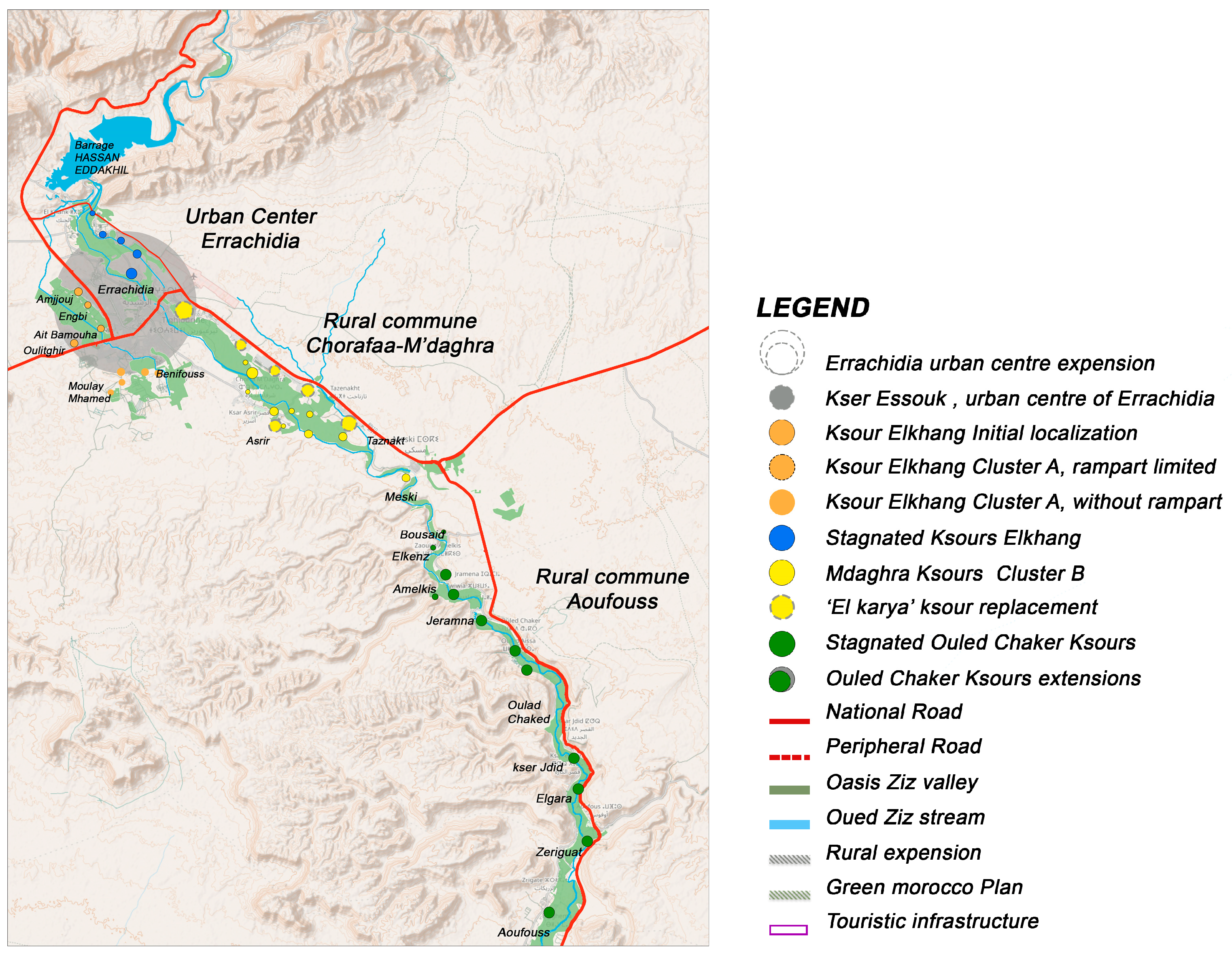
2.1. Study Area

This study was conducted in the Drâa-Tafilalet region, located in the eastern part of Morocco (Figure 1). This region is divided into five provinces comprising sixteen urban and one hundred nine rural communes (area estimated at 88.836 km2). The urbanization rate is estimated at 34.1% in the entire region and 46.1% in Errachidia.
In Errachidia, the climate is arid with hot temperatures. The mean temperature is estimated at 24 °C; higher temperatures are noted in summer (40 °C in August), while in winter (January), the temperature can be as low as 10 °C. The annual precipitation rate is around 100 mm.
The hydrological system of Errachidia is dominated by the Ziz Valley, which feeds more than 200 km of riparian activities. It is divided into three sections: (i) the Upper Ziz (one town and rural sections); (ii) Middle Ziz, (the core of the valley); and (iii) Lower Ziz Valley (the heart of the Tafilalet oasis). Our study was conducted in the middle area of the Ziz Valley.
Firstly, this study area was selected because of its tourism potential; this area receives millions of visitors from both international and national markets [43,44]. Secondly, investigations into the rural villages and their evolution since independence do not exist, particularly in southeastern Morocco.

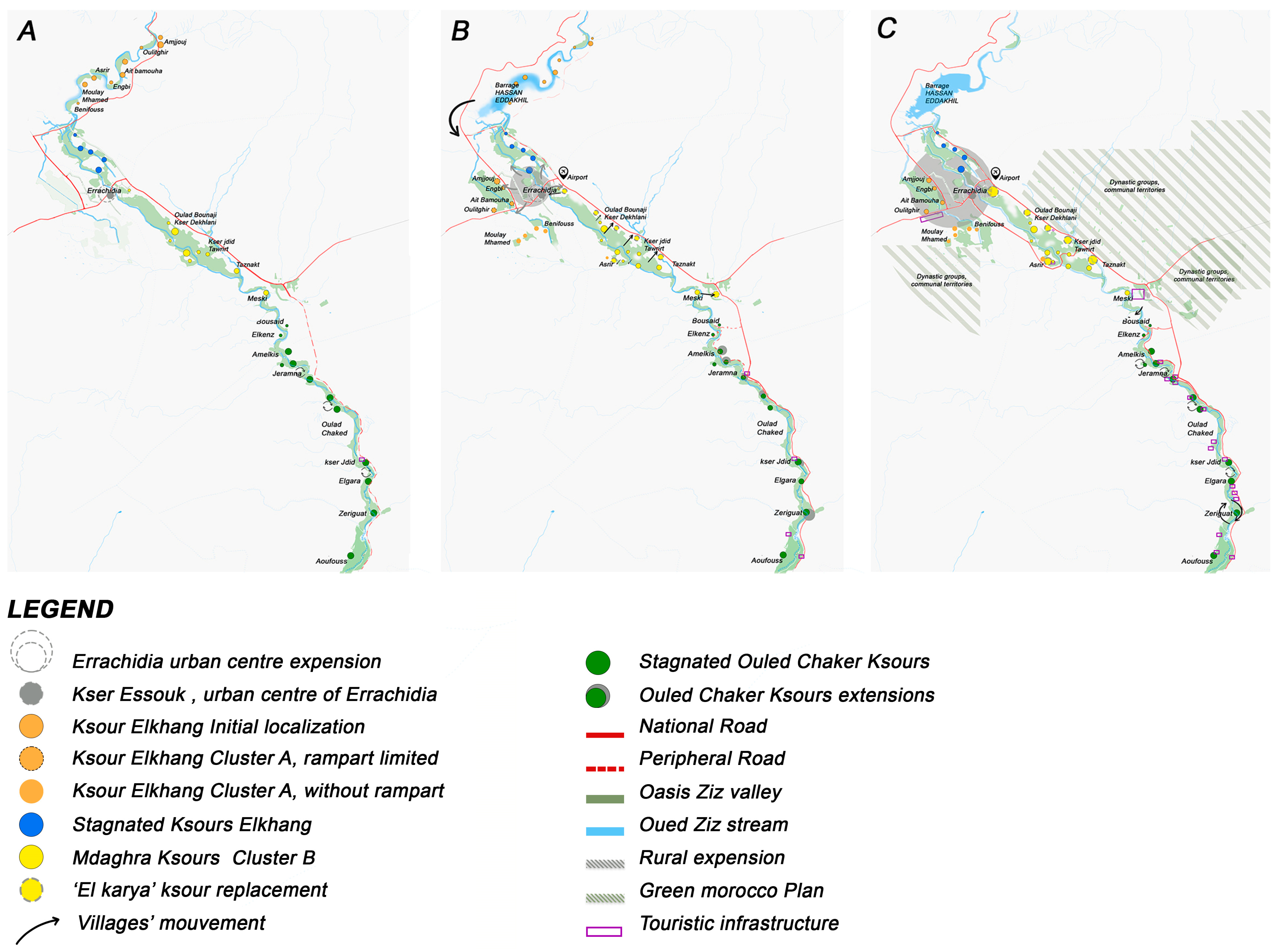
2.2. Selected Villages

In this study, we selected 18 small villages (Table 1) belonging to three different administrative areas (Figure 2). In the urban center of Errachidia, six villages (kser) named Amjjouj, Kser Oulitghir, Ait-Bammouha, Asrir, Moulay Mhmed, and Benifouss were selected. Similarly, six sites, including Kser Oulad-Bounaji, Dekhlani, Jdid, Tawrirt, Tawrirt, Tawnakt, and Meski were selected in the rural commune of Chorafaa-M’daghra. In the rural commune of Aoufouss, we also included six villages, counting Kser Amelkis, Jeramna, Zouiwya, Zouala, Oulad Chaked, and Jdid. These villages were selected in the form of cluster villages (groups of villages belonging to the same administrative commune).

2.3. Data Collection

Before starting field visits, we based our research on institutional reports and previous planning strategies, rural planning, rural oases, and rural tourism from 1956 to 2023 in the province of Errachidia. Then, we collected data related to the demography, economy, and landscape of each village. We conducted field interviews (n = 160) with local authorities, institutional representatives, tourism agents, and residents.

2.4. Inventory of Landscapes

For this section, we collected data on natural and human-made landscapes to evaluate the general changes. The natural landscapes include oases, riparian vegetation, mountainous views, and natural forests. Human-made landscapes are rural buildings, reservoirs, farmlands, reforested areas, created views, irrigation canalization, and newly created infrastructures. We noted their location, dominant elements, and covered area. Then, we recorded the threatening factors.

2.5. Retrospective of Rural Planning Fabric

The data collected (bibliography and field) were used to highlight the manifestations of resilience and sustainability in the social, economic, and environmental dimensions of the rural fabric. These elements were used to map rural oases and to construct a retrospective map of different features (borders, land cover, and dynamics). The impact of environmental (climate, desertification, and floods) and human factors (land cover and urbanization) were included.

2.6. SWOT Analysis

Due to its adaptation to community development and resource management processes, the strengths, weaknesses, opportunities, and threats analysis (SWOT) has evolved into a valuable tool for regions and change management projects of international assistance and development organizations [45]. We investigated each cluster’s (villages) internal operations, capabilities, and facilities for the strength section (physical, natural, and human capital, and rural tourism offers). Then, we identified the cluster’s location and distance from the transportation corridor, infrastructure services, immigrant population, income leaks, and shortcomings. Trends, characteristics, and the economy have been utilized to enhance the stability of communities. We identified opportunities from outside influences that each cluster may benefit from, as well as potential threats. The context analysis is one of the content factors that, when applied, decides if a SWOT analysis is successful. An External Factor Evaluation Matrix (EFEM) aims to study the external environment and to identify the available opportunities and dangers. The EFEM analyzes the interior environment and reveals both its strengths and shortcomings.
A SWOT analysis was performed to assess rural tourism sustainability by analyzing the results and determining the priorities based on the collected and analyzed data of the movement in rural clusters. Then, when the matrices were created, each component was weighted, from 0 for the least important to 1 for the most important, so that the sum of each matrix is 1, as presented in Table 2. Each component was given a score between 1 (worst) and 5 (best), which is helpful in determining how desirable each factor is. A total weighted score of attractiveness with a value greater than 2.5 in the EFEM indicates that the positives outweigh the drawbacks. As in the EFEM, the strengths outweigh the weaknesses when the sum of the weighted scores is more than 2.5.

2.7. Statistics

The collected data were organized in Excel sheets depending on the type of parameters and cluster village. First, we tested the normality of the data with the Shapiro–Wilk test. Then, we compared the areas (ha) of the rural villages among clusters (A, B, and C) and among study periods (1965, 1965–2000, and 2000–2023) with an ANOVA one-way test. A similar test was used to compare the parameters of the SWOT analysis (strengths, weaknesses, opportunities, and threats) among the studied villages. On the other hand, we selected a multivariate analysis to investigate the associations between land cover characteristics and the studied cluster villages. In our case, we used correspondence analysis (CA) because our data were qualitative. The cluster villages were considered as dependent variables (N = 3 cluster villages), while the characteristics of land cover were considered as independent variables. The obtained results were presented in the axes with higher eigenvalues and higher percentages of variance. The statistics were computed in IBM SPSS Statistics 25, and the results are presented as the mean ± SD. Values were considered significant at p ≤ 0.05.

3. Results and Discussions

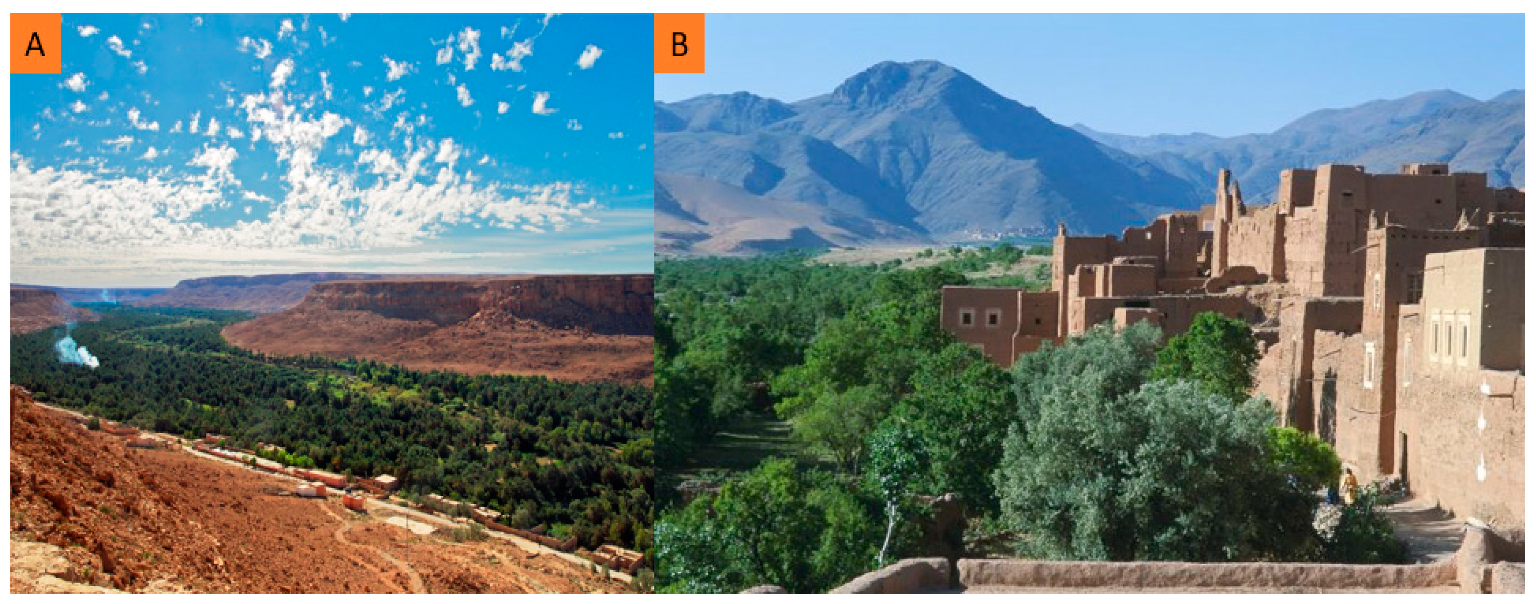
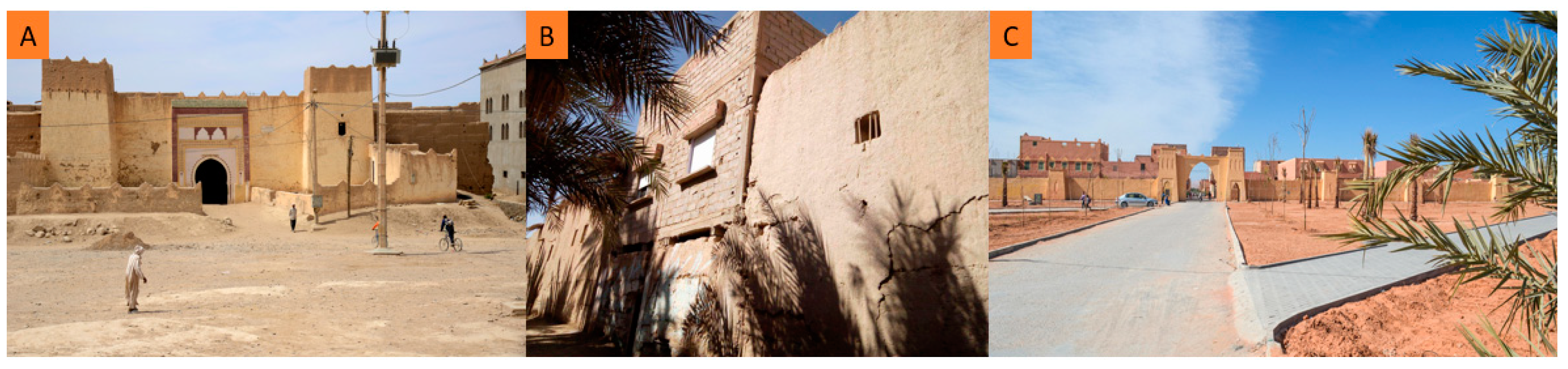
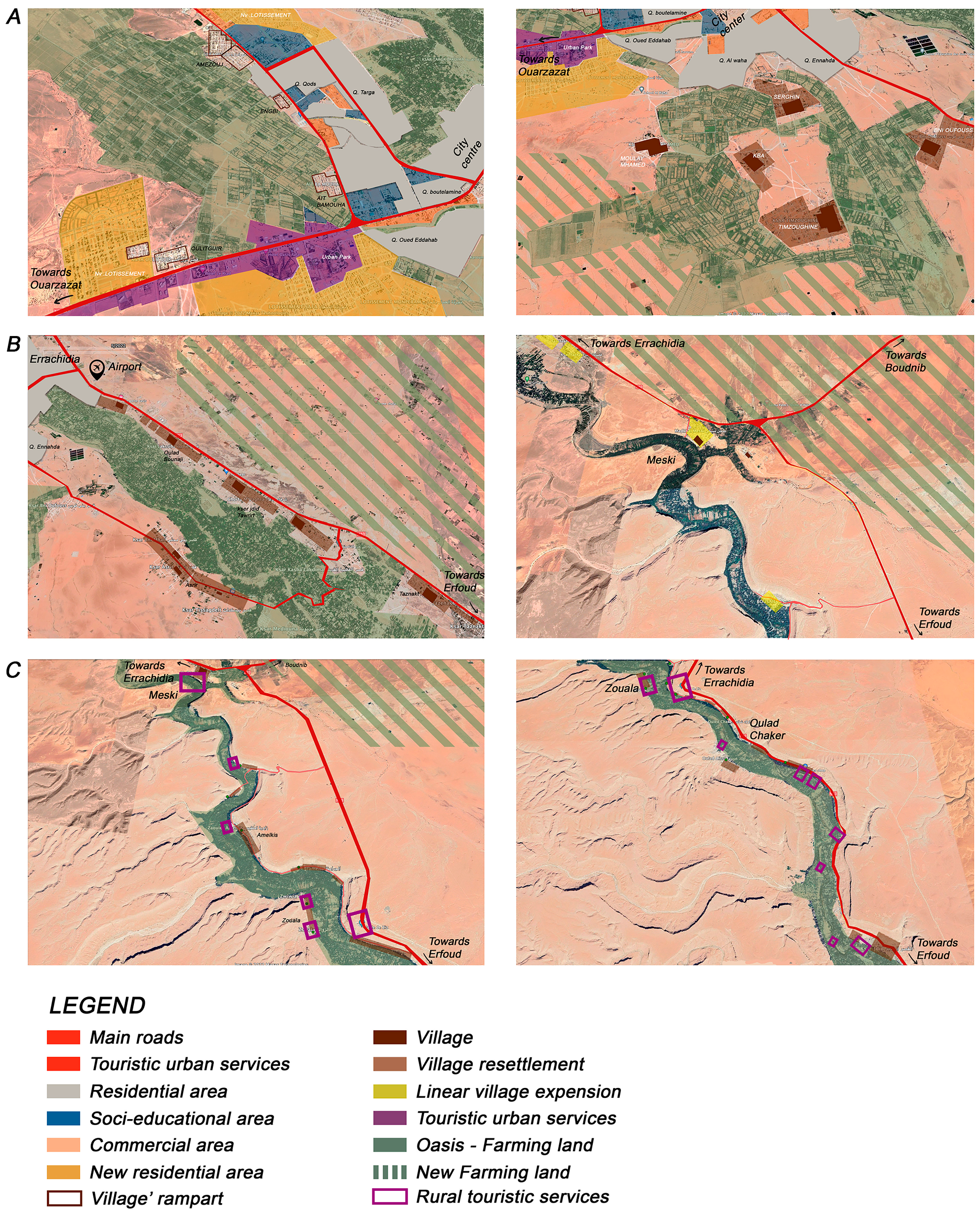
3.1. Current Features of Landscapes

The recorded studied landscapes in the Ziz Valley are presented in Table 3. Natural landscapes (oases and forests) cover an area estimated at 3759.34 ha. Further, six human-made landscapes were documented, including a dam, urban center, historical monuments, new villages, farmlands, and the Meski pool, which cover an estimated area of 12,089.33 ha.
The evolution of infrastructures and human activities in the studied villages has significantly impacted the landscapes. The recorded modifications have impacted the rural villages and landscapes; the villages have been affected by modern buildings and infrastructure (Figure 3 and Figure 4). The ancient monuments were dismantled due to ignorance and environmental factors, and buildings are dominated by modern materials compared to ‘Tabout’ materials. Farmlands of palms were the most dominant around the river. Agronomic (olives, alfalfa, potatoes, tomatoes, peas, and green beans) and invasive plants (Lantana camara, Leucaena leucocephela, Pinus halepensis, and Eucalyptus sp.) have impacted the natural plants and landscapes, such as Tamaris sp., and the oasis integrity. Other landscapes appeared, such as the Ziz reservoir (Al Hassan Adakhil) and the view near National Road N 13. These landscapes resulted from the construction of the dam, the availability of water, and the displacement of ancient villages. In addition, the pumping of water for irrigation deeply impacted the river (scarcity of water). Other factors such as pastoralism, pollution, and low maintenance threaten the landscapes of the Ziz Valley.
This study inventoried the landscapes in the study zone. These sites are diverse and characterized by a wide range of modifications. The Ziz Valley is dominated by human-made landscapes, mainly agro-systems including farms of palm and olives, which need irrigation water [46]. The ancient buildings and monuments have been replaced by modern materials and infiltrated with roads, storage, transport, etc., which have impacted the integrity of rural villages and natural landscapes [47]. The migration of rural populations toward cities (i.e., Errachidia) is suggested to aggravate the situation [48]. For example, uninhabited buildings are threatened by erosion and dismantlement [49]. However, the appearance of reservoirs, riparian oases, and views is suggested to attract more visitors [31,50] and to offer habitats for biodiversity [51,52]. For example, views of the Ziz Valley attract visitors to use its landscapes. The Ziz reservoir is rich in aquatic birds that attract visitors for birding activities. However, the dominance of human-made landscapes threatens natural ecosystems and their functional ecology [53,54].

3.2. Retrospective of Rural Fabrics

The results of the retrospective mapping in the studied areas from 1960 to 2023 are presented in Figure 5. The analysis of maps after the flood of 1965 showed alterations in the landscapes of the studied villages from 1960 to 2023, depending on the sampled periods. Most of the villages were demolished by floods, and their populations migrated to the surrounding areas. The riparian geomorphology was altered by the Ziz Valley’s main river. The area covered by the Errachidia center is limited and located on the Valley’s left side. In the 1971–1980 period, the Al Hassan Adakhil dam was established upstream of the oases. Then, the water accumulated, which created a new aquatic landscape and promoted farmlands. In contrast, the rural villages were impacted by the expansion of the Errachidia center. The villages (ksours) of cluster A, namely Amjjouj, Oulitghir, Ait-Bammouha, Asrir, Moulay Mhmed, and Benifouss were incorporated into Errachidia. In the rural villages of cluster B (the rural commune of Chorafaa-M’daghra), the location of the villages was displaced far from its original place (nearly 1 km) to its new location near the road linking Errachidia and Erfoud. In contrast, cluster C villages (ksours) (rural commune of Aoufouss) were preserved after the flood and dam construction. From 1980 to 2023, the most recorded modification was the expansion of urbanized lands (Errachidia urban center by 400%). Furthermore, the urbanization of Errachidia impacted the cluster A villages. Further, the land cover of cluster B was changed, with agricultural fields on the right side of displaced villages. The cluster C villages were less impacted by urbanization, and their location was preserved. In contrast, farmlands were decreased due to the reduced flow downstream of the dam.
Figure 6 presents the evolution of cluster villages from 1965 to 2023 in the Ziz Valley. The comparison of the villages’ covered areas shows significant variations from 1965 to 2023. The area of cluster A villages significantly increased from 1965 (32.25 ± 1.72 ha) to 2023 (60.39 ± 3.48). Similarly, the villages of cluster B increased from 34.3 ± 1.68 ha in 1965 to 68.77 ± 2.27 ha in 2023. In contrast, the villages of cluster C decreased from 21.49 ± 1.72 ha in 1965 to 11.94 ± 1.46 ha in 2000 and 11.3 ± 1.71 ha in 2023. On the other hand, the comparison between cluster villages shows different results depending on the periods. In 1965 and 1965–2000, the villages of clusters A and B had larger areas compared to the villages of cluster C. In 2000–2023, the area of cluster B villages was significantly larger, followed by the villages of cluster A, while the smallest area was recorded in the villages of cluster C.
In Morocco and North Africa, many studies have addressed the evolution of urban and regression of rural landscapes [38,55,56,57]. However, this is the first study to address the effect of urban areas on rural zones in the oases of southeastern Morocco. The obtained results showed the dissolution of rural villages surrounding the Ziz River. This has been the situation in North Africa since independence [58]. For example, ref. [59] investigated the land cover and farmlands in the Tozeur and Gabes oases (South Tunisia), including the effects of urbanization and globalization on landscapes and the general layout of rural settlements. In Algeria, ref. [60] evaluated the landscapes of natural heritage in the oasis system of Biskra, while [61] investigated the same aspects in the El Kantara and the Sidi Okba Oases. Both authors mentioned urbanization as the main factor behind the regression of landscapes (natural ecosystems and villages).
In our case, the first factor responsible for the modifications in oasis integrity was the flood in 1965, which caused the mortality of a significant population and the destruction of small villages of the Ziz [62,63]. The surviving residents were moved to the urban center of Errachidia, while others constructed new villages far from the river. After the construction of the dam (Al Hassan Adakhil), the activities of villages were extended to the west, due to the availability of water resources [63,64], while the Errachidia center incorporated the cluster A villages between 1971 and 1980. From 1980 to 2023, the rest of the cluster villages were converted into urban areas under the extension of Errachidia. The expansion of farmlands in the Ziz Valley from 1971 to the present was governed by growing demand for products, following the national strategy of Morocco to be a leading agricultural state in North Africa. Additionally, the expansion of the urban center of Errachidia during the same period was due to the growth of the population, estimated currently at nearly 102,154 inhabitants [65].

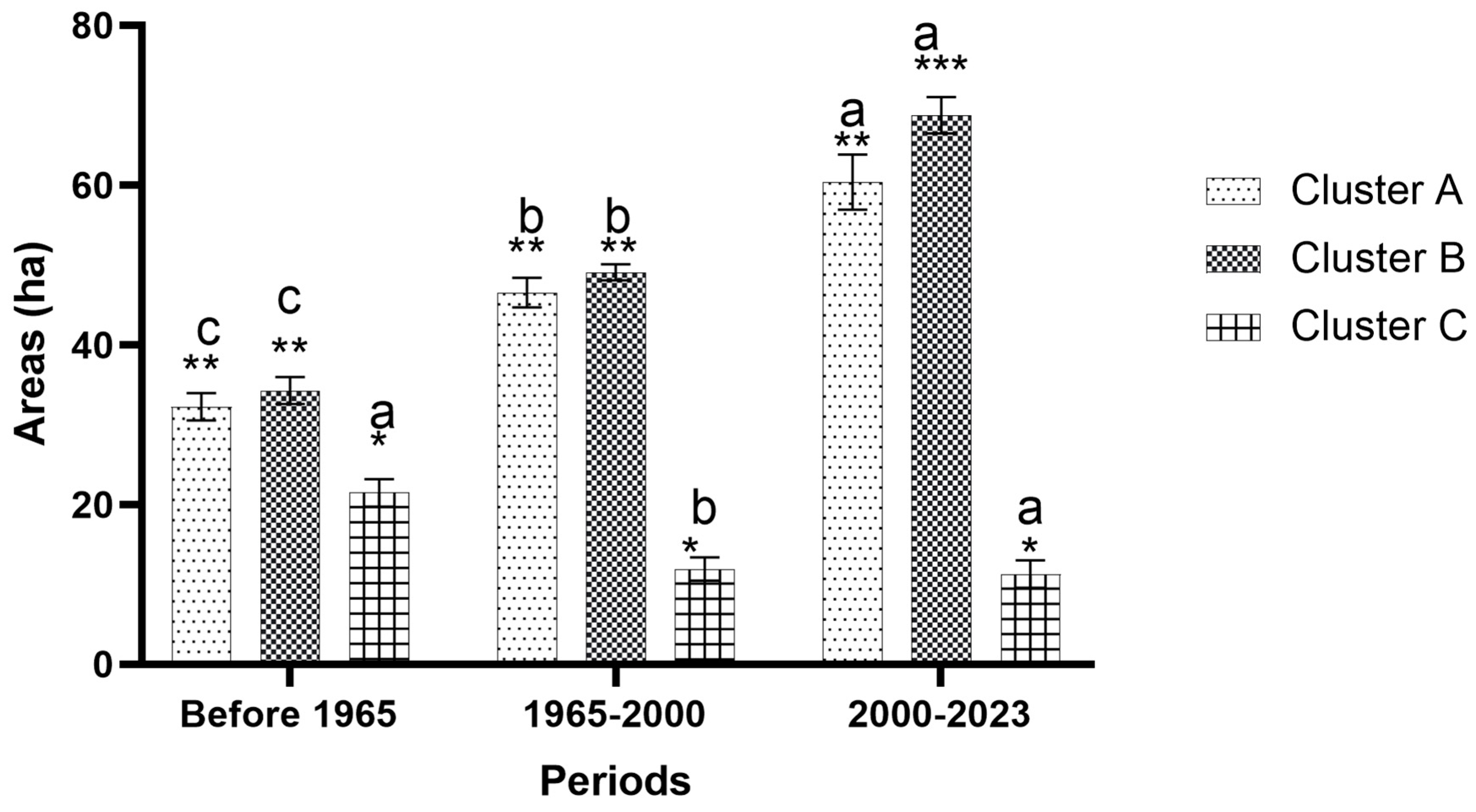
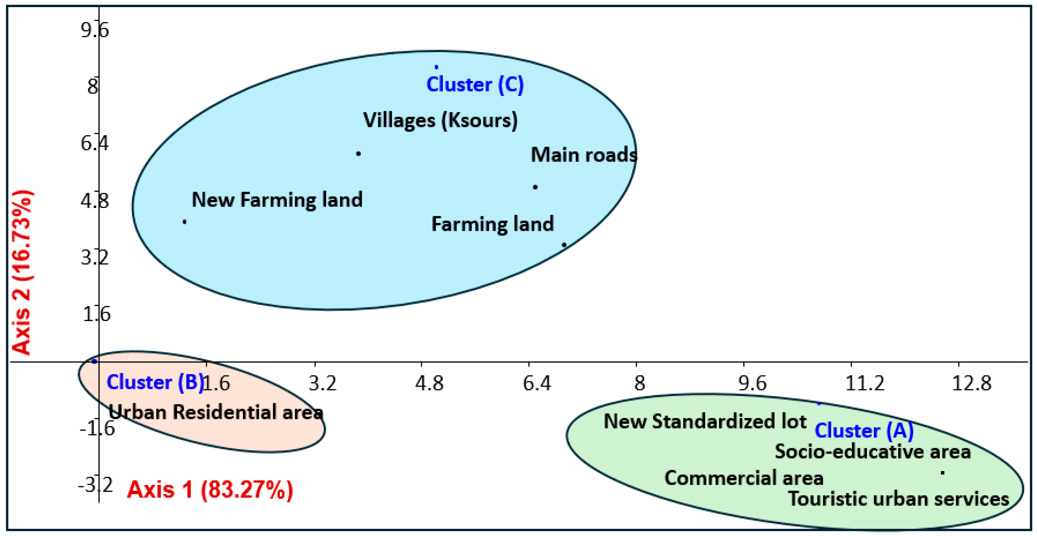
3.3. Land Cover Analysis

The land cover in the urbanized villages grouped in cluster A is presented in Figure 7 and Table 4. Along the western route, a collection of relocated cluster villages was planned; the ramparts preserved the closeness of rural status within the villages. The planning strategies also offered farmlands and projected rural stability. With the growth in urbanization, the “post-ksour” have become resilient individuals living in rural areas inside the city. The expansion of the other group, those outside the ramparts, evolved differently with the creation of farmlands. However, as the city grows, the cluster villages experience both the rural–urban duality and oasis environment.
In detail, 100% of the cluster A villages were urbanized (residential, commercial, and new standardized lots). The farmlands (614.43 ha) are dominated by palm and olive orchards. A portion of the cluster villages in Amjjouj, Oulitghir, and Ait-Bammouha (Figure 7A) (22.72 ha) have kept the ramparts and been equipped with over 51.41 ha of roads. Further, an important area, estimated at 89.24 ha, was converted into a touristic structure. On the other hand, the villages of Asrir, Moulay Mhmed, Benifouss, and Serghin (Figure 7A) were relocated without ramparts, and their farmlands (719.58 ha) are dominated by palm, olives, cereals, and vegetables. Urban zones dominated by buildings cover 113.02 ha, while new standardized lots cover only 66.99 ha. Commercial areas cover a limited area (14.60 ha), while the socio-educative zone covers only 13.36 ha. The displaced villages cover 37.67 ha.
In the cluster B villages from Ouled Bounaji to Meski (Figure 7B), the situation is different; the urban zone is absent. In contrast, the farmlands in the riparian zones of the Ziz Valley and the areas to the east of the road (new farmlands) cover 465.05 ha and 1130 ha, respectively. The linear extension of villages covers nearly 68.77 ha, without any services. Commercial sites are limited to small facilities, while the villages are crossed by 45.50 ha of road traffic.
In cluster (C), including the Meski and Zawiat Amelksi to Oulad Chaker villages (Figure 7C), urbanization is absent. The oasis of the riparian sides covers 256.03 ha in the villages. The newly created farmlands are limited to the eastern area of the valley. The tourist facilities cover only 1 ha. The road traffic is estimated at 32.21 ha, and the original villages were not displaced after the flood. The farmlands in the oasis and newly cultivated area cover 185.66 ha. The tourist sites have been integrated with residential areas, where we found more than 10 sites. The original villages (32.31 ha) of this cluster did not change location.
Figure 8 presents the correspondence analysis (CA) plot of cluster villages and their land cover characteristics. The analysis of the recorded results showed that the data were grouped into three groups, which combined cluster villages with their dominant land cover on two axes, with a percentage variance estimated at 100%. The villages of cluster C are characterized by a dominance of farmland (old and new farms), long roads, and ancient villages. The villages of cluster B are dominated by urban residential areas. In the villages of Cluster A, the lands are occupied mainly by new standardized lots, socio-educative areas, commercial zones, and touristic urban services.
This study details the current situation of land cover in the Ziz Valley and demonstrates for the first time the impact of urban and agricultural activities on the old villages. Further, the original villages of cluster A were replaced by new ones located around Errachidia; then, the expansion of urbanization and agricultural areas impacted them. The other villages have been affected principally by farmlands. Similar results are mentioned in the bibliography, which addresses the Moroccan and North African valleys. Ref. [65] investigated the land cover in Errachidia from 2005 to 2020 with remote sensing (RS) tools. The obtained results showed an increase in the urbanized areas and farmlands around the Ziz Valley. In another study, ref. [66] used both GIS and remote sensing approaches to study the trends in land cover in the middle of the Ziz Oasis and mentioned the expansion of Errachidia and agricultural fields on both sides of the valley. An empirical study was conducted in the entire Drâa-Tafilalet region, including the Ziz Valley, to explore the change in land use for sustainability [67] and recorded that extensive agriculture and urbanization are the most land covers experiencing increased enlargement, while traditional activities and natural heritage decreased from 1973 to 2020. In comparison with other Mediterranean regions, ref. [12] conducted deep research to investigate the pressures and risks to the natural heritage of the Chott Sidi Abdel Salam oasis (Tunisia) and showed that the oasis is impacted by fragmentation (on average 0.62 hectares per farmer) due to chaotic urbanization of agricultural areas (>56.67% of the farmers had built new buildings on farmlands) and successive inheritance. Ref. [68] investigated the effect of flash floods (1900–2012) on the oases and their heritage in Gabes City (Tunisia). The results showed that the floods led to the destruction of oasis villages and their farmlands, and therefore the populations moved to new urban centers, which is exactly in agreement with the case of Ziz. Similar results were recorded in Algeria, where the oasis (heritage building and traditional palm oasis) is threatened by the invasion of urbanization and intensive farmlands [60,69]. Ref. [69] demonstrated that urbanization affected the Biskra Oases (29.13% with medium impact, followed by 13.41% with low sensitivity and 9.45% with high sensitivity). Moreover, ref. [70] recorded that the floods caused huge damage to the village in the Tuareg oasis (Algerian Sahara), which led to the migration of residents away from the streams. On the other hand, the expansion of urbanization inside the villages of Ziz have developed new tourist and commercial spaces, which create new opportunities for visitors and local populations. In fact, the tourist areas create opportunities for local sites, including trips to visit old villages and monumental buildings, while small shops offer artisanal products. For example, ref. [71] recorded the existence of Jewish buildings, synagogues, and mellahs in the oasis of the Drâa-Tafilalet region, which deserves more attention. Similarly, commercial sites bring imported materials to the populations of villages, which offer jobs to increase income. For example, the oases of the Ziz Valley are rich in medicinal plants [72,73], artisanal products [50], natural landscapes, and heritage monuments [71,74,75]. However, the development of sustainable tourism is needed to valorize natural resources and to ensure their rationalism [75,76].

3.4. SWOT Analysis and Rural Tourism Sustainability

For every cluster, Table 5 provides the weighted scores for the opportunities and threats (EFEM) and the strengths and weaknesses (IFEM), respectively. For the cluster A village strength factors, the weights allocated were 0.03–0.19, and the score was around 1–3. Weakness factors were detected with the highest weight of 0.02, the lowest weight of 0.19, and scores of 2–3. The final weighted score was 2.39, implying that strengths were less than weaknesses for rural tourism. In the cluster B and C villages, the weighted scores were estimated at 2.61 and 2.79, respectively. The weights allocated for the strength factors for cluster B (Table 4) were 0.05–0.15, and the scores were estimated at 2–3. For the weakness factors, the highest weight was estimated at 0.05, while the lowest weight was 0.11, and the score was 1–3. In the cluster C villages, the weights allocated for strengths were 0.03–0.12, while the scores were 1–4. In contrast, the weakness factors were detected between 0.11 and 0.09, while the scores were 2–3. These indicate that strengths were greater than weaknesses in the villages of both clusters B and C, which is opposite that of the villages of cluster A.
External Factors Evaluation Matrix: In Table 5, regarding opportunities and threats, four factors for each were identified. In cluster A, for the opportunity factors, the weights allocated were between 0.05 and 0.15, and the scores ranged from 1 to 2. Factors were detected with the highest weight of 0.02 and lowest weight of 0.21, with scores ranging between 2 and 3. The final weighted score was 2.22, implying that strengths were less than weaknesses for rural tourism. In the table presented for cluster B, the weights allocated for opportunity factors were between 0.09 and 0.12, and the scores ranged between 2 and 4. When considering threat factors, the highest weight was 0.07, and the lowest weight was 0.18, with scores ranging between 2 and 3. Cluster C had the weights allocated for opportunities between 0.09 and 0.12, and the scores ranged between 2 and 4. Threat factors were detected with the highest weight of 0.09 and the lowest weight of 0.12, with scores ranging between 2 and 4, implying that, as opposed to cluster A, opportunities were greater than threats in clusters B and C, as the weighted scores are, respectively, 2.81 and 3.37.
The comparison of the SWOT analysis parameters (strengths, weaknesses, opportunities, and threats) is presented in Table 6. The analysis of data presented showed significant variations depending on the type of parameter and cluster village. The weight of strengths was statistically greater in the villages of clusters B and C compared to cluster A. In contrast, the scores and weighted scores of strengths were statistically similar among all the studied villages. The weighted scores and scores of weaknesses were statistically similar among all the villages. In contrast, the weight of weaknesses was statistically greater in the villages of both clusters A and C, while the lower value was recorded in the villages of cluster B. In terms of opportunities, the weight was significantly greater in the cluster C villages, while the value was similar between the A and B cluster villages. Further, the score was significantly greater and similar in both B and C cluster villages compared to the villages of cluster A. In contrast, the weighted score was significantly greater in cluster C, followed by cluster B, while the lowest value was recorded in the villages of cluster A. The threats showed different results depending on the parameters and villages. The weights and weighted scores were statistically similar among all the studied villages. In contrast, the score was significantly greater in the villages of cluster C, while in both clusters A and B, the values were similar.
Our results evaluated for the first time the sustainability of oasis villages in Morocco and the entire North Africa. We demonstrated that the villages of both clusters B and C had a higher potential for sustainable tourism than the villages of cluster A. These results suggest valorizing these villages with sustainable activities including tourism of nature and heritage, as well as agriculture, such as agroecology systems. The use of SWOT analysis was reported in other areas; for example, ref. [77] used a SWOT analysis to evaluate the tourism potential in the western Negev (Israel). The same method was used by [78] to evaluate landscape potential in Bingöl (Turkey). All these studies are based on strengths, weaknesses, opportunities, and threats to evaluate the tourism potential. In our case, the Ziz Valley ecosystems are suitable for sustainable activities including tourism [67,79]. For example, ref. [74] evaluated the cultural heritage of Imghranes Massif (Drâa-Tafilalet) for potential sustainable tourism. These authors suggested geotourism, geoeducation, and cultural tourism as major assets to this region that are expected to enhance the local economy.

4. Recommendations

Based on the analysis of our results, we demonstrated that rural villages are impacted by human and natural factors. Urbanization, farmlands, low maintenance, and infrastructure are the most recorded anthropogenic factors. In terms of natural factors, floods and climate change are the most documented. Therefore, our recommendations are divided into research and conservation avenues.
In terms of research, future investigations need to address the census of rural villages, buildings, and architecture in rural areas of southeastern Morocco. Equally, research needs to assess the lifestyle of rural populations and their socio-economic aspects. The social features include social values and cultures, while the economic aspects include activities that bring income, such as agricultural, artisanal, service, medicinal plants, commercial, etc. In terms of economic aspects, investigations need to address the income from rural tourism and how visitors improve or deteriorate rural values and integrity.
In terms of conservation, the recommendations could be divided into the conservation of villages and the protection of values and cultures of rural life. The conservation of villages includes the maintenance of buildings, historical monuments, and architecture. For example, ref. [71] reported the existence of unfired brick mellahs and synagogues in the Drâa-Tafilalet Region, which need serious conservation actions. In terms of values and cultures, the conservation approaches need to protect the cultural aspects of rural populations such as traditions, artisanal activities, hand-made instruments, music, and related aspects.
The protection and conservation of rural villages need close collaboration among authorities, scientists, and local populations. The scientists are requested to offer in-depth investigations including data on potential, threatening factors, and required actions. The authorities are requested to offer investments and national strategies to conserve the rural features. The sensitization of local populations and their integration into conservation actions are suggested to facilitate the application of the strategies programmed by the authorities [80].

5. Conclusions

This study aimed to investigate the evolution of landscapes and land cover in small clustering villages in the Ziz Valley from 1965 to 2023. Equally, we used SWOT analysis to evaluate the potential of these areas for sustainable tourism. In terms of landscapes, the current situation showed the dominance of human-made systems (i.e., a dam, rural buildings, and agrosystems) compared to natural landscapes. The results of the retrospective mapping showed significant socio-spatial changes in the villages of the oases. The flood of 1965 impacted the land cover and the landscapes leading to the destruction of villages upstream, while their populations emigrated and built new villages. The dam of Hassan Dakhil, built during 1971–1980, accumulated water and led to increased farmland areas on both riparian sides of the Ziz River. The newly built villages of cluster A (i.e., Kser Amjoj and Kser Serghin) were incorporated into the urban zone of Errachidia that grew from 1971 to 2023. Further, cluster B villages (e.g., Kser Meski and Ouled Bounaji) were relocated without being urbanized. In contrast, the cluster C villages (e.g., Zawiat Amelkis) were not affected by floods and didn’t change their original location, which protected them from urban expansion. The construction of the Hassan Dakhil dam and the agricultural trend in the region were the principal reasons behind the extension of farmlands in the Ziz Valley, while the expansion of Errachidia city under demographic pressure, and the construction of new villages near that city, were the main reason behind the dissolution of the villages. However, the urbanization of the Serghin and Amjoj cluster villages created important new structures, including tourist and commercial urban areas, which are suggested to create new opportunities for local populations. The results of the SWOT analysis showed that the strengths were greater than the weaknesses in the villages of both clusters B and C, which is the opposite in the villages of cluster A. Therefore, the villages of B and C have more rural tourism potential compared to the villages of A.

Author Contributions

Conceptualization, K.A.A. and H.R.; methodology, K.A.A.; software, H.R. validation, K.A.A. and H.R.; formal analysis, K.A.A.; writing—original draft preparation, K.A.A.; writing—review and editing, K.A.A. and H.R; supervision, H.R. All authors have read and agreed to the published version of the manuscript.

Funding

This research received no external funding.

Data Availability Statement

The datasets used and/or analyzed during the current study are within the manuscript.

Conflicts of Interest

The authors declare no conflicts of interest.

References

  1. Heffner, K.; Solga, B. Small Towns as Local Economic Centres in Rural Areas. Bull. Geography. Socio-Econ. Ser. 2006, 6, 77–87. [Google Scholar]
  2. Li, Y.; Westlund, H.; Liu, Y. Why Some Rural Areas Decline While Some Others Not: An Overview of Rural Evolution in the World. J. Rural Stud. 2019, 68, 135–143. [Google Scholar] [CrossRef]
  3. Yang, R.; Xu, Q.; Long, H. Spatial Distribution Characteristics and Optimized Reconstruction Analysis of China’s Rural Settlements during the Process of Rapid Urbanization. J. Rural Stud. 2016, 47, 413–424. [Google Scholar] [CrossRef]
  4. Bennett, K.J.; Borders, T.F.; Holmes, G.M.; Kozhimannil, K.B.; Ziller, E. What Is Rural? Challenges and Implications of Definitions That Inadequately Encompass Rural People and Places. Health Aff. 2019, 38, 1985–1992. [Google Scholar] [CrossRef] [PubMed]
  5. Cabral, P.; Augusto, G.; Akande, A.; Costa, A.; Amade, N.; Niquisse, S.; Atumane, A.; Cuna, A.; Kazemi, K.; Mlucasse, R.; et al. Assessing Mozambique’s Exposure to Coastal Climate Hazards and Erosion. Int. J. Disaster Risk Reduct. 2017, 23, 45–52. [Google Scholar] [CrossRef]
  6. Nguyen, T.-T.; Nguyen, T.T.; Do, M.H.; Nguyen, D.L.; Grote, U. Shocks, Agricultural Productivity, and Natural Resource Extraction in Rural Southeast Asia. World Dev. 2022, 159, 106043. [Google Scholar] [CrossRef]
  7. Ma, W.; Jiang, G.; Li, W.; Zhou, T. How Do Population Decline, Urban Sprawl and Industrial Transformation Impact Land Use Change in Rural Residential Areas? A Comparative Regional Analysis at the Peri-Urban Interface. J. Clean. Prod. 2018, 205, 76–85. [Google Scholar] [CrossRef]
  8. Gao, T.; Ivolga, A.; Erokhin, V. Sustainable Rural Development in Northern China: Caught in a Vice between Poverty, Urban Attractions, and Migration. Sustainability 2018, 10, 1467. [Google Scholar] [CrossRef]
  9. Wang, Y.; Li, Y. Promotion of Degraded Land Consolidation to Rural Poverty Alleviation in the Agro-Pastoral Transition Zone of Northern China. Land Use Policy 2019, 88, 104114. [Google Scholar] [CrossRef]
  10. Randelli, F.; Martellozzo, F. Is Rural Tourism-Induced Built-up Growth a Threat for the Sustainability of Rural Areas? The Case Study of Tuscany. Land Use Policy 2019, 86, 387–398. [Google Scholar] [CrossRef]
  11. Wang, Z.; Li, D.; Cheng, H.; Luo, T. Multifaceted Influences of Urbanization on Sense of Place in the Rural–Urban Fringes of China: Growing, Dissolving, and Transitioning. J. Urban Plan. Dev. 2020, 146, 4019026. [Google Scholar] [CrossRef]
  12. Rhouma, A.; Mougou, I.; Rhouma, H. Determining the Pressures on and Risks to the Natural and Human Resources in the Chott Sidi Abdel Salam Oasis, Southeastern Tunisia. Euro-Mediterr. J. Environ. Integr. 2020, 5, 37. [Google Scholar] [CrossRef]
  13. Souissi, I.; Boisson, J.M.; Mekki, I.; Therond, O.; Flichman, G.; Wery, J.; Belhouchette, H. Impact Assessment of Climate Change on Farming Systems in the South Mediterranean Area: A Tunisian Case Study. Reg. Environ. Chang. 2018, 18, 637–650. [Google Scholar] [CrossRef]
  14. Zang, Y.; Liu, Y.; Yang, Y.; Woods, M.; Fois, F. Rural Decline or Restructuring? Implications for Sustainability Transitions in Rural China. Land Use Policy 2020, 94, 104531. [Google Scholar] [CrossRef]
  15. Hinz, R.; Sulser, T.B.; Huefner, R.; Mason-D’Croz, D.; Dunston, S.; Nautiyal, S.; Ringler, C.; Schuengel, J.; Tikhile, P.; Wimmer, F.; et al. Agricultural Development and Land Use Change in India: A Scenario Analysis of Trade-Offs Between UN Sustainable Development Goals (SDGs). Earth’s Future 2020, 8, e2019EF001287. [Google Scholar] [CrossRef]
  16. Mandal, J.; Ghosh, N.; Mukhopadhyay, A. Urban Growth Dynamics and Changing Land-Use Land-Cover of Megacity Kolkata and Its Environs. J. Indian Soc. Remote Sens. 2019, 47, 1707–1725. [Google Scholar] [CrossRef]
  17. El-Ghonemy, M.R. Food Security and Rural Development in North Africa. Middle East. Stud. 1993, 29, 445–466. [Google Scholar] [CrossRef]
  18. Taouraout, A.; Chahlaoui, A.; Belghyti, D.; Najy, M.; Kharroubi, A. The Socio-Cultural Acceptance of EcoSan Latrines in Rural Areas of Morocco. In Proceedings of the 3rd International Conference on Smart City Applications; Association for Computing Machinery: New York, NY, USA, 2018; pp. 1–9. [Google Scholar]
  19. Knickel, K.; Redman, M.; Darnhofer, I.; Ashkenazy, A.; Calvão Chebach, T.; Šūmane, S.; Tisenkopfs, T.; Zemeckis, R.; Atkociuniene, V.; Rivera, M.; et al. Between Aspirations and Reality: Making Farming, Food Systems and Rural Areas More Resilient, Sustainable and Equitable. J. Rural Stud. 2018, 59, 197–210. [Google Scholar] [CrossRef]
  20. Zavratnik, V.; Kos, A.; Stojmenova Duh, E. Smart Villages: Comprehensive Review of Initiatives and Practices. Sustainability 2018, 10, 2559. [Google Scholar] [CrossRef]
  21. Perić, M.; Đurkin, J.; Wise, N. Leveraging Small-Scale Sport Events: Challenges of Organising, Delivering and Managing Sustainable Outcomes in Rural Communities, the Case of Gorski Kotar, Croatia. Sustainability 2016, 8, 1337. [Google Scholar] [CrossRef]
  22. Bacon, C.M.; Getz, C.; Kraus, S.; Montenegro, M.; Holland, K. The Social Dimensions of Sustainability and Change in Diversified Farming Systems. Ecol. Soc. 2012, 17, 41. [Google Scholar] [CrossRef]
  23. Byravan, S.; Ali, M.S.; Ananthakumar, M.R.; Goyal, N.; Kanudia, A.; Ramamurthi, P.V.; Srinivasan, S.; Paladugula, A.L. Quality of Life for All: A Sustainable Development Framework for India’s Climate Policy Reduces Greenhouse Gas Emissions. Energy Sustain. Dev. 2017, 39, 48–58. [Google Scholar] [CrossRef]
  24. Carley, M.; Christie, I. Managing Sustainable Development; Routledge: London, UK, 2017. [Google Scholar]
  25. Montanari, B.; Bergh, S.I. A Gendered Analysis of the Income Generating Activities under the Green Morocco Plan: Who Profits? Hum. Ecol. 2019, 47, 409–417. [Google Scholar] [CrossRef]
  26. Nassri, I.; Tahri, L.; Saidi, A.; Ameur, N.; Fekhaoui, M. Prevalence, Diversity and Antimicrobial Resistance of Salmonella Enterica and Pseudomonas Aeruginosa Isolates from Spring Water in a Rural Area of Northwestern Morocco. Biodivers. J. Biol. Divers. 2021, 22, 1363–1370. [Google Scholar] [CrossRef]
  27. El Baroudi, Y.; Ouazzani, C.; Er-Ramly, A.; Moustaghfir, A.; Essebbahi, I.; Dami, A.; Balouch, L. Nitrite Levels in Well Water from Different Rural Areas in Morocco. Ecol. Environ. Conserv. 2021, 27, 39–47. [Google Scholar]
  28. Giuliani, A.; Mengel, S.; Paisley, C.; Perkins, N.; Flink, I.; Oliveros, O.; Wongtschowski, M. Realities, Perceptions, Challenges and Aspirations of Rural Youth in Dryland Agriculture in the Midelt Province, Morocco. Sustainability 2017, 9, 871. [Google Scholar] [CrossRef]
  29. Berred, S.; Berred, K. Climate Change Issues, Challenges, and Impacts in Terms of Rural Geo-Biological and Cultural Tourism Activity Development in Semiarid Areas: A Case Study from Tata, Bani Geopark (Anti-Atlas, South Morocco). Geoheritage 2021, 13, 110. [Google Scholar] [CrossRef]
  30. Er-Ramy, N.; Nachite, D.; Anfuso, G.; Azaaouaj, S. The Sector Analysis as a Coastal Management Tool for Sustainable Tourism Development on the Mediterranean Coast of Morocco. Sustainability 2023, 15, 12581. [Google Scholar] [CrossRef]
  31. Beraaouz, M.; Abioui, M.; Hssaisoune, M.; Martínez-Frías, J. Khettaras in the Tafilalet Oasis (Morocco): Contribution to the Promotion of Tourism and Sustainable Development. Built Herit. 2022, 6, 24. [Google Scholar] [CrossRef]
  32. Gagnol, L.; Landel, P.-A. Psammotourism: Desert Sand as a Specific Resource and Touristic Experience. Via. Tour. Rev. 2016. [Google Scholar] [CrossRef]
  33. Lahmidi, S.; Lagnaoui, A.; Bahaj, T.; El Adnani, A.; Fadli, D. First Inventory and Assessment of the Geoheritage of Zagora Province from the Project Bani Geopark (South-Eastern Morocco). Proc. Geol. Assoc. 2020, 131, 511–527. [Google Scholar] [CrossRef]
  34. Almeida-García, F. Analysis of Tourism Policy in a Developing Country: The Case of Morocco. J. Policy Res. Tour. Leis. Events 2018, 10, 48–68. [Google Scholar] [CrossRef]
  35. Belhaj, K.; Mansouri, F.; Caid, H.; Sindic, M.; Fauconnier, M.-L.; Boukharta, M.; Elamrani, A. Meat Quality Traits of Béni Guil Lamb Raised in Eastern Morocco, Abstract Published in Atlas Journal of Biology 2018, (pp:490). In Proceedings of the Fourth International American Moroccan, Agricultural Sciences Conference—AMAS Conference IV, Meknes, Morocco, 9–11 May 2018. [Google Scholar]
  36. El Menyari, Y. Effect of Tourism FDI and International Tourism to the Economic Growth in Morocco: Evidence from ARDL Bound Testing Approach. J. Policy Res. Tour. Leis. Events 2021, 13, 222–242. [Google Scholar] [CrossRef]
  37. Hssaisoune, M.; Bouchaou, L.; Sifeddine, A.; Bouimetarhan, I.; Chehbouni, A. Moroccan Groundwater Resources and Evolution with Global Climate Changes. Geosciences 2020, 10, 81. [Google Scholar] [CrossRef]
  38. Bounoua, L.; Fathi, N.; El Berkaoui, M.; El Ghazouani, L.; Messouli, M. Assessment of Sustainability Development in Urban Areas of Morocco. Urban Sci. 2020, 4, 18. [Google Scholar] [CrossRef]
  39. Ayed Mouelhi, R.B.; Ghazali, M. Structural Transformation in Egypt, Morocco and Tunisia: Patterns, Drivers and Constraints. Econ. Transit. Instit. Chang. 2021, 29, 35–61. [Google Scholar] [CrossRef]
  40. Bogdan, A.; Chambre, D.; Copolovici, D.M.; Bungau, T.; Bungau, C.C.; Copolovici, L. Heritage Building Preservation in the Process of Sustainable Urban Development: The Case of Brasov Medieval City, Romania. Sustainability 2022, 14, 6959. [Google Scholar] [CrossRef]
  41. Chastre, C.; Ludovico-Marques, M. Chapter 13—Nondestructive Testing Methodology to Assess the Conservation of Historic Stone Buildings and Monuments. In Handbook of Materials Failure Analysis; Makhlouf, A.S.H., Aliofkhazraei, M., Eds.; Butterworth-Heinemann: Oxford, UK, 2018; pp. 255–294. ISBN 978-0-08-101928-3. [Google Scholar]
  42. Romagny, B.; Aderghal, M.; Auclair, L.; Ilbert, H.; Lemeilleur, S. From Rural to Urban Areas: New Trends and Challenges for the Commons in Morocco. J. N. Afr. Stud. 2023, 28, 57–74. [Google Scholar] [CrossRef]
  43. Boulaalam, O.; Aghoutane, B.; Ouadghiri, D.E.; Moumen, A.; Cheikh Malinine, M.L. Proposal of a Big Data System Based on the Recommendation and Profiling Techniques for an Intelligent Management of Moroccan Tourism. Procedia Comput. Sci. 2018, 134, 346–351. [Google Scholar] [CrossRef]
  44. Maada, L.; Al Fararni, K.; Aghoutane, B.; Farhaoui, Y.; Fattah, M. A Proof of Concept Web Application for Sentiment Analysis in Tourism in the Region of Draa-Tafilalet. 2022. Available online: https://www.scitepress.org/Papers/2021/107359/107359.pdf (accessed on 22 January 2024).
  45. Beltramo, R.; Rostagno, A.; Bonadonna, A. Land Consolidation Associations and the Management of Territories in Harsh Italian Environments: A Review. Resources 2018, 7, 19. [Google Scholar] [CrossRef]
  46. Ben Salem, S.; Ben Salem, A.; Karmaoui, A.; Yacoubi Khebiza, M. Vulnerability of Water Resources to Drought Risk in Southeastern Morocco: Case Study of Ziz Basin. Water 2023, 15, 4085. [Google Scholar] [CrossRef]
  47. El Assaoui, N.; Sadok, A.; Merimi, I. Impacts of Climate Change on Moroccan’s Groundwater Resources: State of Art and Development Prospects. Mater. Today Proc. 2021, 45, 7690–7696. [Google Scholar] [CrossRef]
  48. Berriane, M.; de Haas, H.; Natter, K. Social Transformations and Migrations in Morocco; International Migration Institute Network (IMI): Leiden, The Netherlands, 2021. [Google Scholar]
  49. Berred, K.; Youssi, M.E.; Berred, S. Inventorying Rabat-Salé-Kénitra Region’s Geological Heritage Within Central Morocco: A Useful Tool for Developing Regional Geotourism Activity. Geoheritage 2022, 14, 91. [Google Scholar] [CrossRef]
  50. Kagermeier, A.; Amzil, L.; Elfasskaoui, B. The Transition of Governance Approaches to Rural Tourism in Southern Morocco. Eur. J. Tour. Res. 2019, 23, 40–62. [Google Scholar] [CrossRef]
  51. Hamza, F.; Kahli, A.; Almalki, M.; Chokri, M.-A. Distance from Industrial Complex, Urban Area Cover, and Habitat Structure Combine to Predict Richness of Breeding Birds in Southeastern Tunisian Oases. Environ. Sci. Pollut. Res. 2022, 29, 33191–33204. [Google Scholar] [CrossRef] [PubMed]
  52. Samimi-Namin, K.; Hoeksema, B.W. Hidden Depths: A Unique Biodiversity Oasis in the Persian Gulf in Need of Further Exploration and Conservation. Diversity 2023, 15, 779. [Google Scholar] [CrossRef]
  53. Aziz, T. Terrestrial Protected Areas: Understanding the Spatial Variation of Potential and Realized Ecosystem Services. J. Environ. Manag. 2023, 326, 116803. [Google Scholar] [CrossRef] [PubMed]
  54. Lamqadem, A.A.; Afrasinei, G.M.; Saber, H. Analysis of Landsat-Derived Multitemporal Vegetation Cover to Understand Drivers of Oasis Agroecosystems Change. J. Appl. Remote Sens. 2019, 13, 014517. [Google Scholar] [CrossRef]
  55. Adnani, A.E.; Habib, A.; Khalidi, K.E.; Zourarah, B. Spatio-Temporal Dynamics and Evolution of Land Use Land Cover Using Remote Sensing and GIS in Sebou Estuary, Morocco. J. Geogr. Inf. Syst. 2019, 11, 551–566. [Google Scholar] [CrossRef]
  56. Loulad, S.; Nguyen, T.T.; Simou, M.R.; Rhinane, H.; Buerkert, A. Monitoring Rural-Urban Transformation in the Coastal Region of Rabat-Sale-Kenitra, Morocco. PLoS ONE 2023, 18, e0290829. [Google Scholar] [CrossRef]
  57. Squalli, W.; Mansouri, I.; Douini, I.; Achiban, H.; Fadil, F.; Dakki, M.; Wink, M. Diversity of Avian Species in Peri-Urban Landscapes Surrounding Fez in Morocco: Species Richness, Breeding Populations, and Evaluation of Menacing Factors. Diversity 2022, 14, 945. [Google Scholar] [CrossRef]
  58. Blake, G.H. Urbanisation in North Africa: Its Nature and Consequences. In The City in the Third World; Dwyer, D.J., Ed.; The Geographical Readings Series; Macmillan Education UK: London, UK, 1974; pp. 67–80. ISBN 978-1-349-86177-4. [Google Scholar]
  59. Carpentier, I.; Gana, A. Changing Agricultural Practices in the Oases of Southern Tunisia: Conflict and Competition for Resources in a Post-Revolutionary and Globalisation Context. In Oases and Globalization: Ruptures and Continuities; Lavie, E., Marshall, A., Eds.; Springer Geography; Springer International Publishing: Cham, Switzerland, 2017; pp. 153–176. ISBN 978-3-319-50749-1. [Google Scholar]
  60. Berbache, H.; Khaoui, M.; Hadjab, M. The Oasis System in Southern Algeria: A Natural Heritage Threatened with Disappearance, Case of the Oasis of Biskra. Technium Soc. Sci. J. 2022, 34, 588. [Google Scholar] [CrossRef]
  61. Bouzir, T.A.K.; Berkouk, D.; Zemmouri, N. Evaluation and Analysis of the Algerian Oases Soundscape: Case of El Kantara and Sidi Okba. Acoust. Aust. 2020, 48, 131–140. [Google Scholar] [CrossRef]
  62. Hsain, I. Small-Scale Irrigation in a Multiethnic Oasis Environment: The Case of Zaouit Amelkis Village, Southeast Morocco. J. Political Ecol. 1996, 3, 89–106. [Google Scholar] [CrossRef]
  63. Karmaoui, A.; Issam, I.; Babqiqi, A.; Messouli, M.; Yacoubi Khebiza, M. Analysis of the Water Supply-Demand Relationship in the Middle Draa Valley, Morocco, under Climate Change and Socio-Economic Scenarios. J. Sci. Res. Rep. 2016, 9, 1–10. [Google Scholar] [CrossRef] [PubMed]
  64. El Ouali, A.; El Hafyani, M.; Roubil, A.; Lahrach, A.; Essahlaoui, A.; Hamid, F.E.; Muzirafuti, A.; Paraforos, D.S.; Lanza, S.; Randazzo, G. Modeling and Spatiotemporal Mapping of Water Quality through Remote Sensing Techniques: A Case Study of the Hassan Addakhil Dam. Appl. Sci. 2021, 11, 9297. [Google Scholar] [CrossRef]
  65. Karmaoui, A.; Ben Salem, A.; El Jaafari, S.; Chaachouay, H.; Moumane, A.; Hajji, L. Exploring the Land Use and Land Cover Change in the Period 2005–2020 in the Province of Errachidia, the Pre-Sahara of Morocco. Front. Earth Sci. 2022, 10, 962097. [Google Scholar] [CrossRef]
  66. Essahlaoui, A.; Mohamed, A.; Lhou, E.; Mohamed, F.; Abdelkader, L. Integration of Remote Sensing and GIS in Studying Land Cover Trends and Conditions in the Middle Ziz Oasis, Morocco. Int. J. Geosci. 2013, 4, 1018–1023. [Google Scholar] [CrossRef]
  67. Akdim, M.; Akdim, H.; Sabiri, A.; Alami, A. Land-Use Change and Sustainability in the South-Eastern Oases of Morocco. Bull. Geography. Socio-Econ. Ser. 2023, 59, 95–109. [Google Scholar] [CrossRef]
  68. Dahri, N.; Abida, H. Causes and Impacts of Flash Floods: Case of Gabes City, Southern Tunisia. Arab. J. Geosci. 2020, 13, 176. [Google Scholar] [CrossRef]
  69. Berghout, K.; Dridi, H. Integration of GIS and Multi-Criteria Analysis for the Assessment of the Sensitivity to Urbanization in Biskra and Its Neighboring Oases, Algeria. GeoJournal 2022, 87, 4219–4234. [Google Scholar] [CrossRef]
  70. Miara, M.D.; Negadi, M.; Tabak, S.; Bendif, H.; Dahmani, W.; Ait Hammou, M.; Sahnoun, T.; Snorek, J.; Porcher, V.; Reyes-García, V.; et al. Climate Change Impacts Can Be Differentially Perceived Across Time Scales: A Study Among the Tuareg of the Algerian Sahara. GeoHealth 2022, 6, e2022GH000620. [Google Scholar] [CrossRef]
  71. Matoušková, E.; Pavelka, K.; Smolík, T.; Pavelka, K. Earthen Jewish Architecture of Southern Morocco: Documentation of Unfired Brick Synagogues and Mellahs in the Drâa-Tafilalet Region. Appl. Sci. 2021, 11, 1712. [Google Scholar] [CrossRef]
  72. Eddouks, M.; Ajebli, M.; Hebi, M. Ethnopharmacological Survey of Medicinal Plants Used in Daraa-Tafilalet Region (Province of Errachidia), Morocco. J. Ethnopharmacol. 2017, 198, 516–530. [Google Scholar] [CrossRef]
  73. Eddouks, M.; Ajebli, M.; Hebi, M. New Indices for Ethnotoxicological Assessment of Medicinal Plants: Example of Tafilalet Region, Morocco. Curr. Drug Saf. 2019, 14, 127–139. [Google Scholar] [CrossRef]
  74. Aichi, A.; Ezaidi, S.; Abioui, M.; Ezaidi, A. Cultural Heritage in Imghranes Massif (Drâa-Tafilalet Region, Morocco): An Optimist’s Contribution and Opportunity for the Local People and Sustainable Tourism. Int. J. Innov. Appl. Stud. 2022, 37, 387–391. [Google Scholar]
  75. Wakass, S.; Ezaidi, A.; El Youssi, M.; Mansouri, I.; Achiban, H.; Chellik, S.; El Azzouzi, M. Geosites of High Atlas of Marrakech (Morocco): Geological Characterization, Accessibility, and Potential Interests for Sustainable Tourism. Geoheritage 2023, 15, 107. [Google Scholar] [CrossRef]
  76. Rezaei, N.; Nofre, J.; Ghaderi, Z. World Heritage Classification and Tourism: Divergent Trajectories in Marrakech Medina (Morocco) and M’Zab Valley (Algeria). J. Herit. Tour. 2023, 19, 111–128. [Google Scholar] [CrossRef]
  77. Collins-Kreiner, N.; Wall, G. Evaluating Tourism Potential: A SWOT Analysis of the Western Negev, Israel. Tour. Int. Interdiscip. J. 2007, 55, 51–63. [Google Scholar]
  78. Mansuroğlu, S.; Dağ, V. Evaluation of landscape potentials of Bingöl province with regard to rural tourism opportunities (using SWOT analysis method). Mediterr. Agric. Sci. 2016, 29, 9–16. [Google Scholar]
  79. Boumahdi, I.; Zaoujal, N. Regional Subjective Well-Being through a Media Sentiment Index: Case of the Drâa-Tafilalet Oasis Region in Morocco. Reg. Sci. Policy Pract. 2023. [Google Scholar] [CrossRef]
  80. Muntifering, J.R.; Clark, S.; Linklater, W.L.; Uri-Khob, S.; Hebach, E.; Cloete, J.; Jacobs, S.; Knight, A.T. Lessons from a Conservation and Tourism Cooperative: The Namibian Black Rhinoceros Case. Ann. Tour. Res. 2020, 82, 102918. [Google Scholar] [CrossRef]
Figure 1. Drâa-Tafilalet region location in eastern Morocco (A), Geographical location of Ziz Valley in Drâa-Tafilalet region (B), Administrative repartitions of Drâa-Tafilalet region (C).
Land 13 00482 g001
Figure 2. Location of selected villages in Errachidia Province.
Land 13 00482 g002
Figure 3. Landscapes and general views of the Ziz Valley (A) and buildings in rural villages (B).
Land 13 00482 g003
Figure 4. Low maintenance of ancient buildings (A) and infiltration of modern buildings (B) and infrastructures (C).
Land 13 00482 g004
Figure 5. Retrospective of rural movement and locations in the Ziz Valley. (A) Before 1965; (B) 2000; (C) 2023.
Land 13 00482 g005
Figure 6. Evolution of cluster villages from 1965 to 2023 along the Ziz Valley (comparison between clusters: *** > ** > *; and comparison between periods: a > b > c).
Land 13 00482 g006
Figure 7. Comparison of land cover in studied cluster villages of the Ziz Valley (A) Cluster A environment; (B) Cluster B environment; (C) Cluster C environment.
Land 13 00482 g007
Figure 8. Correspondence Analysis (CA) showing the associations between studied villages and dominant land cover characteristics in Ziz Valley.
Land 13 00482 g008
Table 1. Names and administrative repartition of selected villages.
Cluster VillagesSelected KsoursAdministrative Repartition
AKser AmjjoujUrban Center Errachidia
Kser Oulitghir
Kser Ait-Bammouha
Kser Asrir
Kser Moulay Mhmed
Kser Benifouss
BKser Oulad-BounajiRural commune
Chorafaa-M’daghra
Kser Dekhlani
Kser jdid
Kser Tawrirt
Kser Tawnakt
Kser Meski
CKser AmelkisRural commune
Aoufouss
Kser Jeramna
Kser Zouiwya
Kser Zouala
Oulad Chaked
Kser jdid
Table 2. Weighted scores for strengths and weaknesses (Internal factor estimate matrix; IFEM).
Cluster ACluster BCluster C
L’kheng/ErrachidiaChorafaa M’daghraAoufouss
WeightScoreWeighted ScoreWeightScoreWeighted ScoreWeightScoreWeighted Score
Strengths
1Natural resource potential.0.0310.030.0530.150.0840.32
2Community engagement in rural lifestyle.0.0710.070.1230.360.0840.32
3Locals supporting tourism.0.0410.040.0730.210.1220.24
4Integration in the urban system.0.0120.080.0820.160.0310.03
5Cultural enhancement and patrimonial deposits.0.0410.110.1120.220.140.4
6Rurality’s locations and geographical positions. 0.1930.150.1530.450.0820.16
Weaknesses
1Inadequate services’ infrastructure, and fundamental tourism facilities.0.0920.180.120.20.1130.33
2Weak market consciousness, and lack of coordination.0.1930.570.1130.330.1120.22
3Patrimonial physical capital deterioration.0.0230.060.0730.210.0930.27
4Seasonality of tourism and unequal distribution of tourism.0.0620.120.0510.050.120.2
5Architectural and morphological clash with urbanization0.1730.510.0930.270.130.3
Total1---2.391---2.611---2.79
Table 3. Landscape characteristics in the Ziz Valley.
LandscapesTypeLocationCovered Area (ha)Threats
ReservoirHMNorth2232Climate change, pollution, transpiration, pumping
FarmlandsHMBoth sides of the valley2590.22Climate change, scarcity of water
Meski poolHMMeski village7.79Scarcity of water and wastes
Ancient villages and buildingsHMBoth sides of the valley161.47Degradation, climatic factors, low maintenance
MonumentsHMVillages52.85Degradation, climatic factors, low maintenance
OasisNRiparian zones3759.34Climate change, scarcity of water, farmlands,
Riparian forestNRiparian zones3759.34Climate change, scarcity of water, farmlands, and pastoralism
Table 4. Estimated areas of land cover in the cluster villages of the Ziz Valley.
DesignationCluster (A)Cluster (B)Cluster (C)
With RampartWithout Rampart
Total studies area (ha)1618.771603.8532003200
Main roads (ha)51.4113.3445.5032.21
Touristic urban services (ha)89.2425.52----
New standardized lot (ha)235.5066.99----
Urban residential area (ha)209.10113.02322,441.134--
Socio-educative area (ha)497.8713.36----
Commercial area (ha)215.9814.60----
Villages (ksours) (ha)22.7237.6768.7732.31
Farming land (ha)614.43719.58465.05256.03
New farming land (ha)----1130185.66
Table 5. Weighted scores for opportunities and threats (External Factor Evaluation Matrix, EFEM).
Cluster ACluster BCluster C
L’kheng/ErrachidiaChorafaa M’daghraAoufouss
WeightScoreWeighted ScoreWeightScoreWeighted ScoreWeightScoreWeighted Score
Opportunities
1Historical, cultural, and traditional inheritance attraction.0.0710.070.1240.480.1540.6
2Growth in market demand and high international interest in rural tourism.0.0510.050.1140.440.1430.42
3Positive guidance and boosting of the development strategies.0.1520.30.0920.180.120.2
4Local communities already informally practicing rural tourism.0.0710.070.120.20.240.8
Threats
1Conflicts between the traditional culture and modern planning.0.220.40.1620.320.0930.27
2Development and protection paradigm.0.230.60.1730.510.140.4
3Biodiversity destruction and vulnerability.0.2130.630.1830.540.1240.48
4Transport infrastructure not to standards.0.0420.10.0720.140.120.2
1---2.221---2.811---3.37
Table 6. Comparison of SWOT analysis parameters (strengths, weaknesses, opportunities, and threats) among studied villages of the Ziz Valley (statistically a > b > c).
Cluster A Cluster B Cluster C
L’kheng/Errachidia Chorafaa M’daghra Aoufouss
WeightScoreWeighted ScoreWeightScoreWeighted ScoreWeightScoreWeighted Score
Strengths0.063 ± 0.06 b1.5 ± 0.83 b0.08 ± 0.04 b0.09 ± 0.04 a2.67 ± 0.52 a0.26 ± 0.12 a0.08 ± 0.03 a2.83 ± 1.33 a0.25 ± 0.13 a
Weaknesses0.11 ± 0.07 a2.6 ± 0.55 a0.29 ± 0.23 a0.08 ± 0.02 b2.4 ± 0.89 a0.21 ± 0.10 a0.10 ± 0.01 a2.6 ± 0.55 a0.26 ± 0.05 a
Opportunities0.09 ± 0.04 b1.25 ± 0.5 b0.12 ± 0.12 c0.11 ± 0.01 b3.00 ± 1.15 a0.33 ± 0.15 b0.15 ± 0.04 a3.25 ± 0.96 a0.51 ± 0.26 a
Threats0.16 ± 0.08 a2.5 ± 0.57 b0.43 ± 0.24 a0.15 ± 0.05 a2.5 ± 0.57 b0.38 ± 0.18 a0.10 ± 0.01 a3.25 ± 0.95 a0.34 ± 0.12 a
Disclaimer/Publisher’s Note: The statements, opinions and data contained in all publications are solely those of the individual author(s) and contributor(s) and not of MDPI and/or the editor(s). MDPI and/or the editor(s) disclaim responsibility for any injury to people or property resulting from any ideas, methods, instructions or products referred to in the content.

