1. Introduction
Global concerns such as urbanisation, tenure insecurity, land conflict, and unequal land access have increased the demand for reliable and up-to-date land information. To meet such requests and guarantee ownership rights, scholars have advocated for the development of an information system that can provide records on “who owns what piece of land”, what type of right and value exists”, and “what use is permissible” on time. The performance of these functions lies within the domain of land administration. “Land administration is a process of determining, recording, and disseminating information about land ownership, value, use, and associated resources” [
1]. According to Enemark [
2], the success of land administration depends on an efficient land information system (LIS). The LIS is a broad-reaching and complex concept that eludes any simple definition. It encapsulates all the simple unofficial procedures undertaken by individuals or small groups aimed at identifying and organising distinct units of property over a small area, as well as the enormous complex set of spatial data acquisition and organisation at the level of a state [
3]. The LIS may also refer to all the coordinated and standardised land-related data banks that have the land parcel as the common geographic unit, which work together to provide an integrated methodology for the collection, maintenance, update, and utilisation of land-related information [
3]. Thus, a well-designed and well-implemented LIS enhances land record management and efficient access to information and reduces the bureaucracies in land administration processes [
4]. Countries that have successfully implemented the LIS for land administration continue to realise the benefits. For instance, experience from developed countries like the Netherlands has demonstrated the usefulness of the LIS in making geographic data accessible to all, promoting transparency and facilitating individual choices about real estate [
5].
Unlike developed countries, implementing the LIS in developing countries is challenging [
6,
7]. As a result, in developing countries where the LIS is in place, its full potential often remains unexplored [
8]. For example, after efficiently implementing the LIS in Rwanda, the bureaucratic nature of the registration system discouraged landowners from registering their properties, thereby making the LIS outdated [
9]. A similar experience happened in Kenya, where the LIS became outdated due to informal land transactions [
10]. Other challenges may result from inadequate land data, poor data quality, and the government’s unwillingness to invest in LIS [
11].
The journey to developing a digital LIS in Ghana has lasted nearly two decades. This resulted in the development of the Ghana Enterprise Land Information System (GELIS) and, subsequently, the Enterprise Land Information System (ELIS). While the former was deployed to integrate the processes of land registration and land use planning across the Lands Commission (LC) and Land Use and Spatial Planning Authority (LUSPA), the latter was introduced to integrate and automate the processes of registration across the four divisions of the LC in Accra (Ghana’s capital). Despite the digitalisation drive and the numerous developments over almost two decades, manual processes still prevail and remain insurmountable within Ghana’s LC. Although the factors that account for this paradoxical situation remain unclear, the plan of the LC is to replicate the LIS across the country. To undertake the nationwide upscaling of the LIS, the current LIS must be assessed to understand its underlying challenges. Such an assessment will help identify ways to improve the system’s functionality in Accra and pave the way for the contextual implementation of the system in the other regions of Ghana. This study, therefore, seeks to assess the effectiveness of the LIS implemented in Accra.
Our study provides valuable insights into the challenges and paradoxes surrounding digitalisation efforts in developing countries, particularly within bureaucratic arenas. Essentially, this study not only addresses immediate concerns related to the implementation of the LIS but also advances theoretical and practical knowledge in the fields of technology adoption, governance, and development in low-income countries.
The rest of this paper is structured as follows:
Section 2 provides a theoretical overview of the LIS and explores the various frameworks used in the literature to evaluate LIS performance.
Section 3 provides an overview of the study setting and methods used in this study.
Section 4 presents the dynamic of digital transformation as it takes place within Ghana’s LC, which is discussed in
Section 5. The conclusion of this study is presented in
Section 6.
3. Materials and Methods
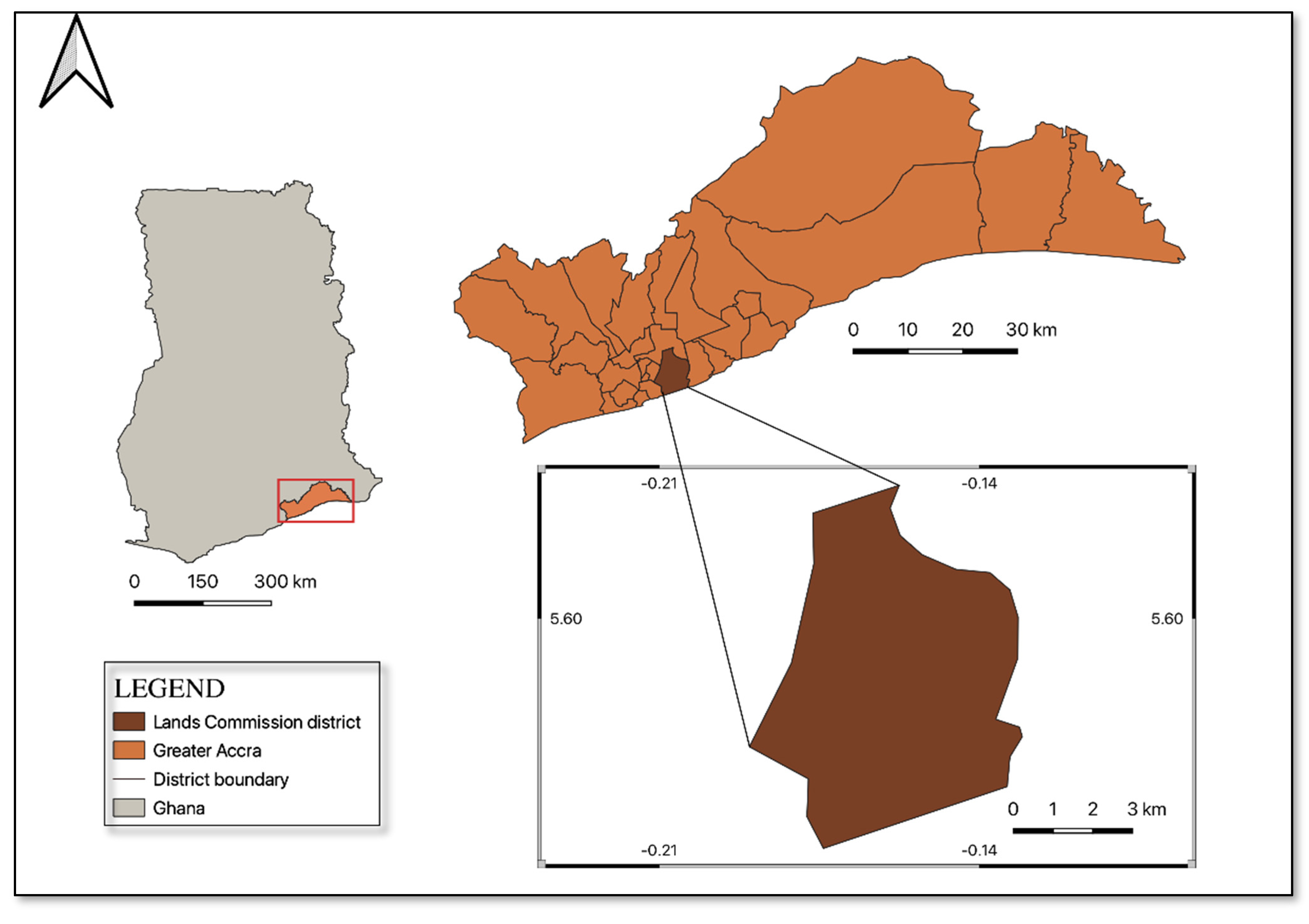
This study draws insight from Accra’s LC on a sub-national scale. Accra is the capital and most populated city of Ghana (see
Figure 2). The land governance structure in Accra is decentralised among stools, families, states, and individuals; therefore, a person who wants to acquire land must obtain consent from these institutions. It is the only region in Ghana with its entire geographical space declared a title registration area. Currently, the LC is the only body mandated by law to issue land title certificates; this legally centralises the overall land information management in Accra to the LC.
The LAS in Ghana is predominantly analogue [
41]. In Ghana’s first and second land administration projects, plans were made to transition the land administration sector into a digital system by establishing the LIS for title registration under LAP 1 and the GELIS in LAP 2 [
42]. After these interventions, positive steps have been taken towards implementing LIS. For instance, part of the country’s LAS has been digitalised in seven of Ghana’s sixteen regions, with Greater Accra as the pilot area.
The digitisation drive in Ghana has become very apparent. Section 73 of Act 1036 [
43] mandates the LC to establish a LIS equipped with the necessary technological artefact to enhance land interests’ transfer, creation, and registration. The Act further requires that capacity be made available for utilising the information system. Although this is a brilliant initiative, it will require more than a legal framework for a successful implementation.
Accra was selected as the study area because it has a working LIS that can be assessed across different aspects of land registration. Also, because the region serves as the capital of Ghana, land market transactions are brisk, thus increasing the need for up-to-date land information.
3.1. Data Sources
This research uses both primary and secondary data. The primary data were collected through interviews with key informants from Accra’s LC and questionnaires from users (clients) of LC’s services. The key informants were officials from different units of the LC, namely, the Land Registration Division (LRD), Land Valuation Division (LVD), Survey and Mapping Division (SMD), Client Service Access Unit (CSAU), IT department, and Management. These respondents were selected based on (i) their knowledge of the topic, (ii) their level of involvement in activities within the LC, and (iii) their willingness and availability. Furthermore, to understand how the information system has improved land service delivery, a convenient sampling technique was used to obtain information from clients, i.e., landowners. In total, twenty-three clients were interviewed. Also, eleven key informants were purposefully selected to provide relevant information about the LIS of Accra’s LC.
The secondary data comprised published scientific articles, books, reports, and legal and policy documents. We used these secondary data to understand the existing LIS and its governing regulations. Also, we used it to review the existing assessment frameworks.
3.2. Data Analysis
The analysis of the data for this paper was performed in two phases. The first phase comprised the choice made to arrive at the final assessment framework following the review of the literature. Given that the Ghanaian LIS is at its developmental stages, it basically consists of three broad aspects, namely (a) how people interact with the LIS and the rules that govern them, (b) the technological adoption and deployment required for a functional LIS, and (c) sustaining the LIS across the LC and the public. These aspects influenced our choice of three elements from the existing frameworks, namely (a) governance and people, (b) the operational environment, and (c) sustainability measures to assess the LIS in Ghana.
To analyse the primary data across different data sources, we first transcribed the interview recordings and the field notes into text. Then, we used conventional content analysis to synthesise the text using the identified themes as a guide. To do this, we went through the transcripts to identify statements, words, and expressions aligning with the themes and indicators identified in
Section 2.3. This step enabled us to sort the responses to create a picture of the administrative processes of registration in Accra’s LC, highlighting the characteristics of the LIS.
4. Results
This section presents the empirical findings on the state of the LIS in Accra’s LC. First, we describe the actual processes of land registration across the four divisions of the LC. In the second step, we describe the broader framework within which the operations of the LC are mobilised. This involves cross-governance (specifically, we look at the policy and legal frameworks that direct land registration), the operational environment (focusing on the deployment of technology, data, and support systems), and sustainability strategies (focusing on the strategies deployed to ensure long-term success in terms of professional and system development).
4.1. Land Administration Processes in Accra’s LC
Land administration processes in Accra combine digital and manual systems. Four divisions of the LC discharge these processes: surveying and mapping, land valuation, public and vested land management, and land registration. However, other land agencies, such as the Land Use and Spatial Planning Authority and the Customary Land Secretariat, assist in the processes. It is relevant to mention that other units/agencies such as the Client Service Access Unit (CSAU), IT, and Universal Merchant Bank (UMB) play a vital role in land administration in the region. While the UMB assists with payment proceedings between clients and the LC, the IT provides technical support. The CSAU, established in 2016, is a one-stop shop directly connecting clients to the divisions; thus, all division application requests are submitted through the CSAU. The processes undertaken by the divisions are granting concurrence, granting consent, plan approval and barcoding, tax value assessment, verification, processing, and certification. The parts of the processes integrated into the system’s functionalities are outlined in the following sub-sections.
4.1.1. Processes of the Public and Vested Land Management (PVLMD)
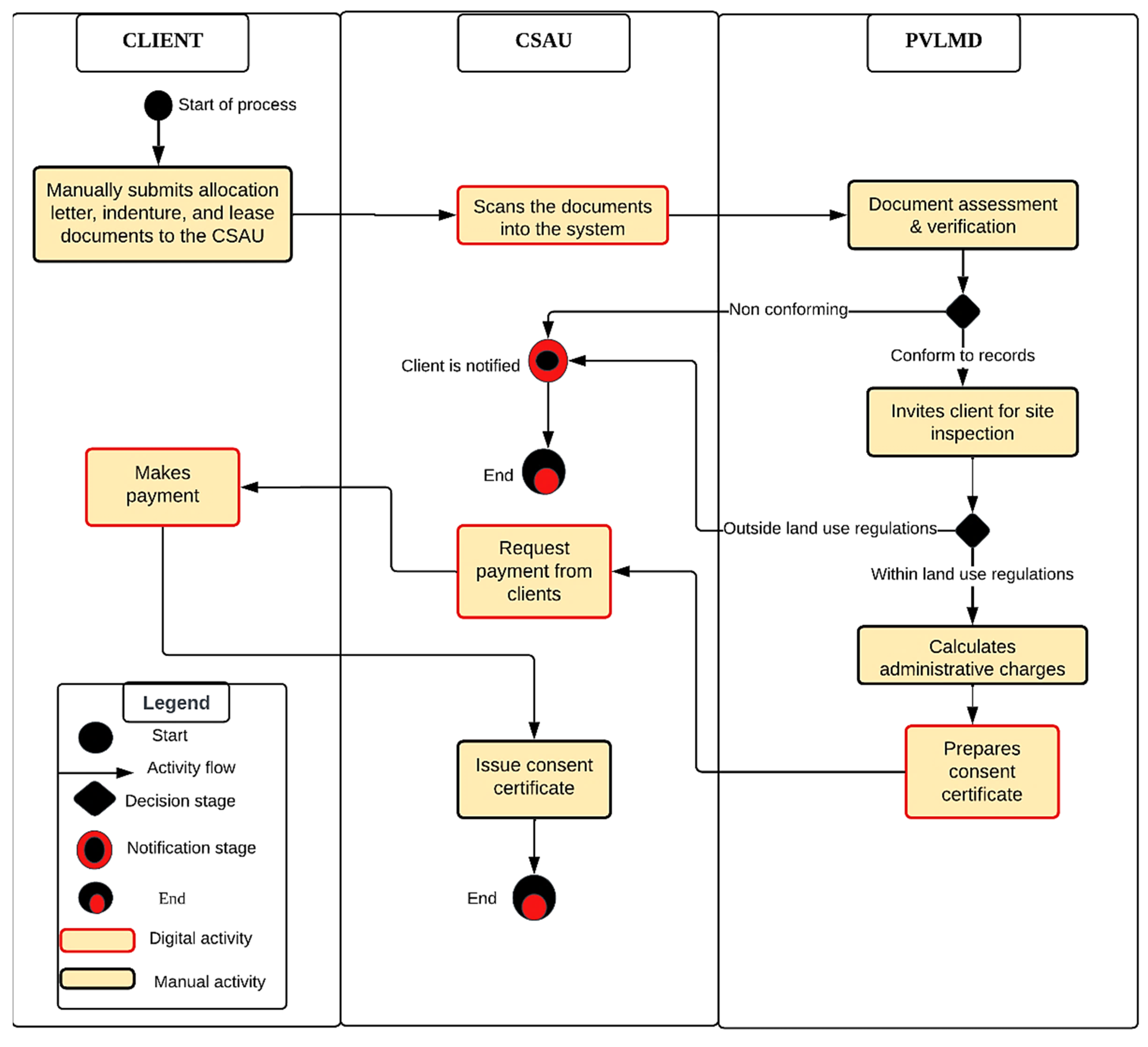
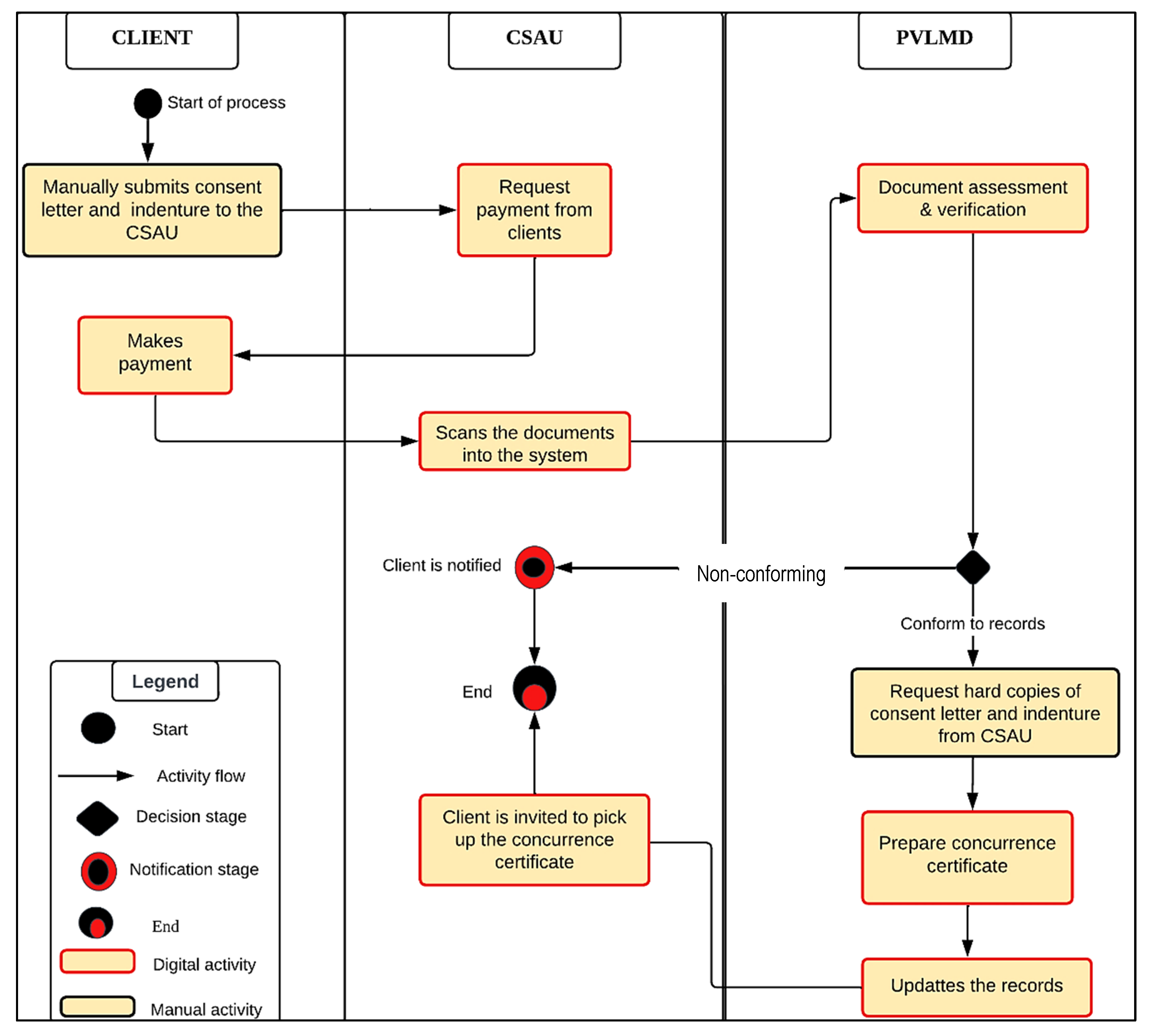
The activities of the PVLMD involve granting consent and concurrence on stool lands. Concurrence is an indication that the LC bears witness to the transaction that has taken place between a party and a stool. On the other hand, the consent process indicates transaction approval for a party who acquired either public or stool land and sought to transfer ownership to another party. Both processes are outlined in
Figure 3 and
Figure 4.
Granting Consent
The party who first acquired the land from either the government or stool submits an allocation letter, indenture, and the lease for that particular land at the CSAU. The PVLMD representative at the CSAU scans the documents into the system. The scanned and hard copy documents are forwarded to the back office of the PVLMD for assessment. At the back office, the documents are checked against the digital records in the system to verify the actual ownership. The applicant is invited for a site inspection if everything conforms to the records. This process is to confirm if the current land use conforms to planning regulations. If the land use conforms, consent to transfer ownership is granted, and the respective administrative charges are assessed by the officer in charge and paid by the applicant. After payment, the applicant is invited via SMS to pick up the consent certificate. It is relevant to mention that from the beginning of the process to this point, only the granting of consent is involved. Suppose an applicant wishes to record the consent with the Commission. In that case, they must submit the consent certificate with copies of their indenture and note of allocation for plotting and pay the associated charges. This means that if clients do not request that their certificates be recorded, the LC will have no consent records.
Granting Concurrence
A client manually submits a consent letter and an indenture from the stool to the CSAU and requests for an application for concurrence. The client is requested to make the necessary payment using the online system or the bank option at the CSAU. After payment, a representative from the PVLMD at the CSAU scans the documents into the system. The scanned and hard copy documents are forwarded to the back office of the PVLMD for assessment. At the back office, the documents are verified against the digital records in the system to confirm if the applicant is buying from the appropriate stool. The PVLMD officer requests the hard copy documents and issues the concurrence certificate for plotting if all details are correct. Copies of the certificate are made available at the CSAU for the applicant to pick up. When one PVLMD officer was asked why they requested hard copy documents after obtaining the digital version the response was, “what if the scanned document were fake? We need the original copies for certification and plotting to be sure”.
4.1.2. Processes of the Survey and Mapping Division (SMD)
The SMD activities involve plan approvals that encompass barcoding and cadastral plan preparation. During this process, the applicant submits copies of plans; this plan must include a computational file of how coordinates were picked from the site and approval by a private license surveyor. The SMD officer checks the quality of the plan using Topcon tools. The plan is scanned into the system if all the quality indicators are met. A barcode containing the parcel’s exact location is generated using the ELIS.
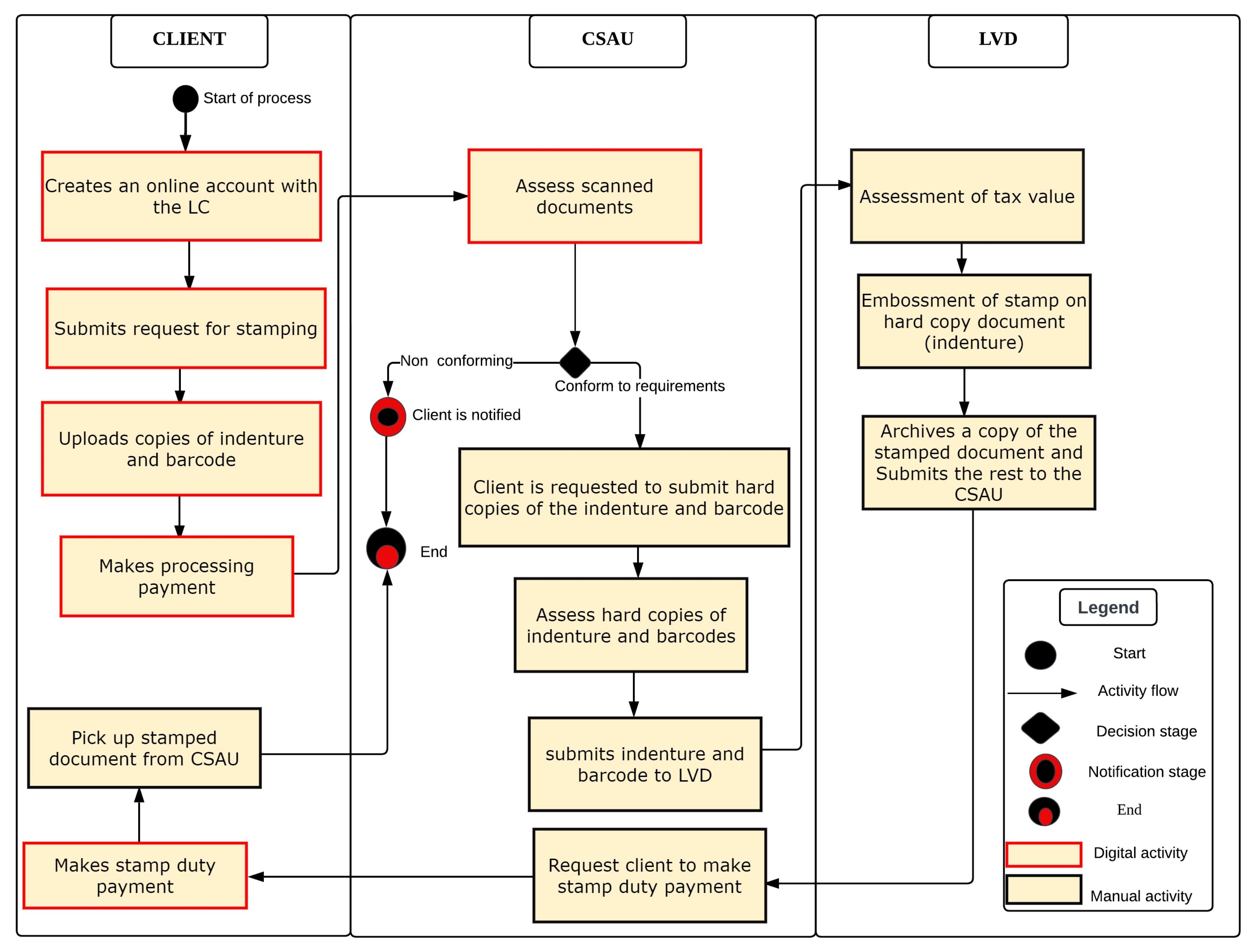
4.1.3. Processes of the Land Valuation Division (LVD)
According to an interview with the LVD respondents, this division’s main activity is assessing a property’s tax value before land registration begins. To assess the tax payable on the value of a property (land), clients must first create an account with the LC on their portal and submit a request for stamping, also known as the tax value. After making this request, the client scans and uploads copies of the indenture (an agreement between the buyer and the seller) and makes the processing payment. A valuation representative receives the request at the CSAU for assessment. If all details conform to the requirement, the client is invited by mail to submit the original documents to the CSAU for further vetting and acknowledgement. Even though resubmitting the physical documents for further assessment appears to be a task duplication, this process is necessary because the original document is legally required to have a physical stamp or seal, which cannot be embossed on the scanned copy. The CSAU batches the document into the system and manually hands it over to the stamping officer to assess and determine the tax amount. Documents are batched into the system and manually submitted to the CSAU for the client to make the stamp duty payment and collection. It is relevant to mention that each activity undertaken under each of the processes could be tracked down by the client in the system.
Figure 5 outlines the workflow activities in the stamping process.
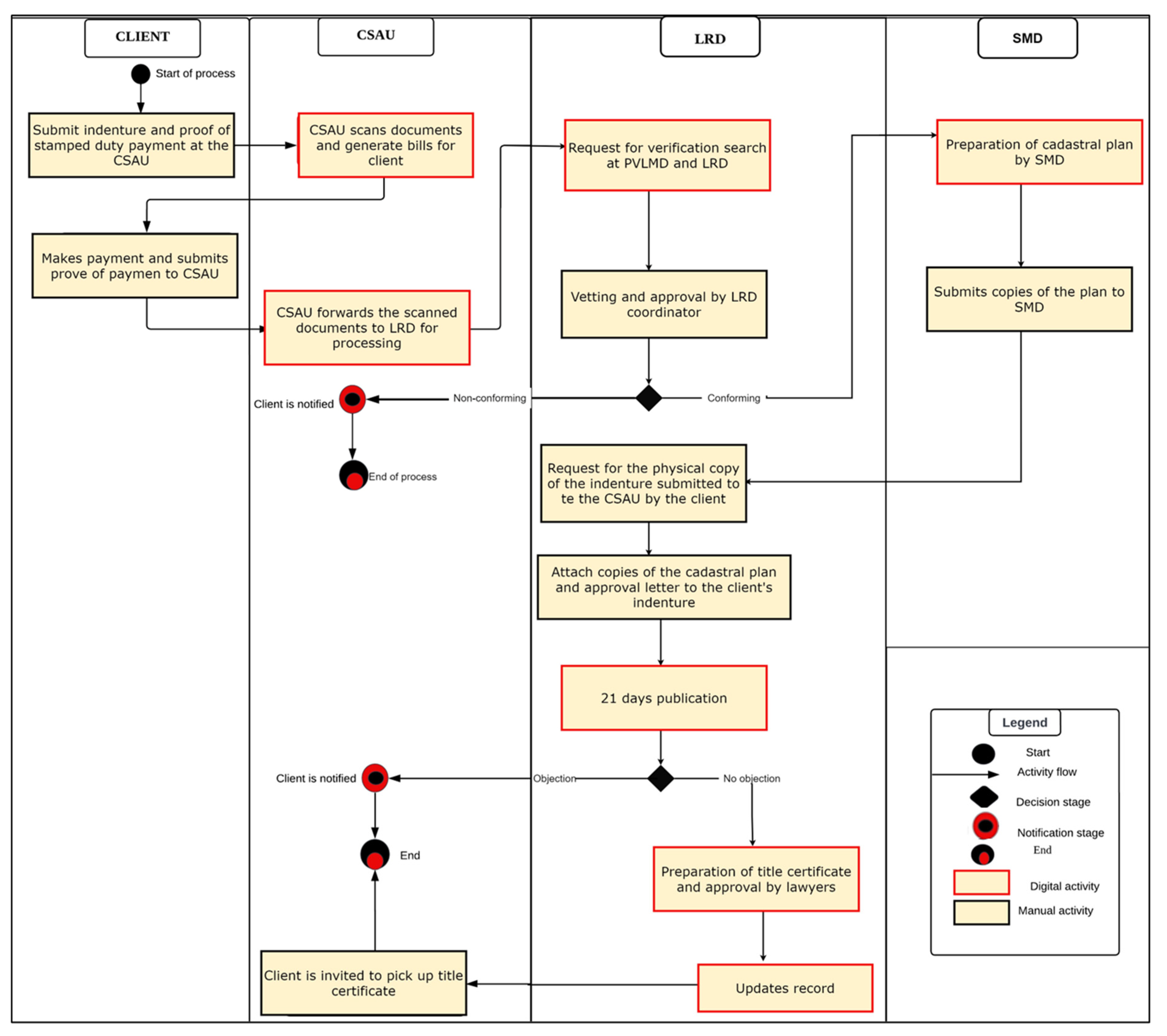
4.1.4. Processes of the Land Registration Division (LRD)
The land registration process in Accra involves title registration of stool lands, family and individual lands, and public and vested lands. This process depends on successfully executing all the processes and activities of the SMD, PVLMD, and LVD. The functions performed by these divisions serve as input for land title registration, i.e., the pre-registration process. To initiate registration, the client must submit an indenture and proof of stamp duty payment that the valuation has issued. Thus, depending on the type of land, if it is state or stool land, a copy of the concurrence letter issued by the PVLMD is added and manually submitted to the LRD representative at the CSAU. The documents are scanned into the system by the CSAU. A bill is generated for the client to pay. This payment is made either through UMB or online.
The scanned documents are forwarded to the PVLD and SMD for verification search when payment is confirmed. The verification search is to verify whether the land has been registered in any name apart from the name on the document. The documents are sent digitally to the coordinator for vetting and approval when the verification search is complete; the SMD is then notified to prepare a cadastral plan if all information is correct. It is relevant to mention that the registration process from the time the documents are scanned into the system to this point takes place in the digital environment. However, everything reverses to the manual process after cadastral plan preparation. Copies of the cadastral plans are submitted to the LRD. The LRD prints out all documents (an approval letter from the coordinator and the cadastral plan). These documents are placed on the client’s file submitted at the beginning of the process and submitted for publication. The documents are forwarded for final approval if no objection is raised after 21 days of publication. The title certificate is prepared and delivered to lawyers for approval. The certificate goes back to LRD for updating, and the client is notified to pick up the title certificate at the CSAU at the end of the process.
Fieldwork results show that there is a database containing all PVLMD and SMD records; however, officers from the LRD are not adequately skilled in retrieving such information from the database. As a result, they rely on the PVLMD and SMD to verify clients’ documents. Due to this dependency, obtaining results from the verification search typically takes days to weeks, delaying the registration process.
Figure 6 illustrates the workflow activities in the registration process.
4.2. Governance and People
The operations of the LC are established under a clear guiding policy and legal instruments. The development of land administration processes, including LIS, is mainly guided by the National Land Policy, the Lands Commission Act, Act 767 (2008), and the Land Act, 2020 (Act 1036). The National Land Policy sets the broader framework for land administration. The Lands Commission Act details the job roles, positions, divisional functions, and general organisational setup. The Land Act details land relations, tenure types, registration processes, and restitution. Additionally, the Land Act establishes an electronic conveyance and mandates the Commission to develop an information system with adequate technological infrastructure to facilitate such conveyancing [
43]. The foreground for electronic transactions in Ghana was already laid down in 2008 by the enactment of the Electronic Transaction Act to support digital signatories that may be required to replace manual stamps and signatures in the conveyancing processes.
The conveyancing process at the LC cuts across different land rights, which are specified in section 1 of the Land Act [
43]. The Land Act recognises and allows for registering allodial, usufructuary, customary freehold, customary tenancy, and leasehold interests. However, there is a gap between what is specified in the law and what is performed in practice. This implementation gap leads to the non-registration of some interests. According to officials of the LRD, the registration processes typically result in leaseholds neglecting other land rights recognised by law. The officials indicated that registration of usufructuary interests in the current system truncates it to a leasehold interest, and such a transformative effect of registration deters usufructs from registration. This is perhaps the case because the earlier legislation on registration (Land Title Registration Act, Act 152 (1986)) did not provide sufficient guidance on registering other interests. Later, the Land Act provided some steps to register the usufructuary interest. For example, section 39(4) of the Land Act states that “a conveyance of a usufructuary interest shall state the interest conveyed as the usufructuary interest and shall not (a) be expressed as a lease, and (b) have a limited term or duration”. Similarly, the law bars the acquisition of customary freehold interests in stool/skin and family lands but remains silent on that of individual and private lands. To this end, some clarity is still required to implement the Land Act.
To undertake registration, the divisions of the LC deploy different procedures, which require standardisation within each division and gateways across divisions for seamless service delivery. For instance, in preparing a cadastral plan, the SMD requires the coordinates of the parcel, size of the parcel in its imperial units, bearing, plan number, registration district and locality, scale, surveyors’ signature, and other relevant numbers. These are different from the specifications required by the PVLMD in granting concurrence. According to an interview with SMD, PVLMD, LVD, and LRD officials, all other standards governing data are specified and regulated by legal instruments such as LI1444 for regulating cadastral plan supervision and approval. Additionally, efforts are made to check the compliance of submitted documents to these standards.
As a result of registration, the LC keeps data about individuals, groups, and entities, the usage and storage of which raises privacy concerns. Privacy, protection, access, and restriction to data are clearly outlined in Act 843 [
44] and Act 989 [
45]. Everyone in Ghana has the right to information; however, access to such information should not result in undue loss or gain to a person, a group, a financial institution, or any other body [
45]. Thus, the LC duly assesses every request for information/data to determine whether the application safeguards the life or liberty of the party(s) involved.
Like any organisation in a digital transformation, staff and clients require a positive attitude toward adopting new technologies. The staff acknowledges that the digital LA system enables a well-organised and less bureaucratic service delivery and is willing to employ its functionalities in their daily business processes; however, not all the clients are willing to adopt this system. On the other hand, Management has implemented strict measures in the system’s usage; thus, one cannot initiate the registration process without deploying the system’s functionalities.
4.3. Operational Environment
The uptake of technology in the operations of the LC has increased steadily over the years. In the Accra office, which doubles as the head office, many measures have been implemented to provide all relevant hardware and software to fulfil the information system requirement. This is evident in the availability of servers, computers, printers, barcode scanners, and other related accessories. However, the distribution of the hardware is uneven across divisions. While considerable hardware was found in the IT unit, CSAU, LRD, PVLMD, and SMD, little was seen at the LVD. Some officials of the LVD indicated that they use their personal computers for the execution of their roles.
Moreover, other responses from Management indicated that the LC uses the ELIS, which is internally developed based on their business needs. Thus, the ELIS interface varies across the various divisions. The LC also uses Topcon tools and open-source software such as PostgreSQL (version 13) and QGIS (version 3.34 LTR) for database management and geographic data processing. Provision has also been made for server backup; however, the type of backup could not be disclosed due to security reasons. Nonetheless, the LC divisions face uneven data entry and conversion challenges due to the deteriorated state of old cadastral maps.
To interact with the LC using digital systems, the staff and the public need operational manuals to guide their interaction with the system. However, interviews with staff across the units of the LC, namely, the CSAU, PVLMD, SMD, LVD, and LRD, reveal that no such operational manuals were available to guide in the convenient use of the system. Provision has however been made for a brochure that outlines the purpose and goals of the information system. They also indicated that IT staff is available to provide the needed guidance in any operational difficulties. Aside from the absence of an operational manual, the divisions/departments are not in unanimous agreement concerning the system’s usability regarding its interface and access to standard features for their daily business activities. In an interview, the SMD, LVD, LRD, and CSAU indicated that the system’s interface keeps changing automatically without their prior knowledge. As a result, they sometimes spend an entire day trying to understand and work with the updated interface. If such understanding has not been derived, the entire land administration process must be kept on hold.
Furthermore, the LVD also stated that the system does not provide all the relevant features needed for their scope of work. In assessing the taxable value, the LVD must emboss a stamp on the document; this feature is currently non-existent because the system is being developed incrementally. While all departments have indicated that the system is sometimes unreliable due to operational malfunctions, they all attest that the system has suitable navigational components and is focused on the needs of the Commission. The majority of clients who have interacted with the system share similar sentiments with land officers concerning its reliability. A total of 20 out of the 23 respondents indicated that it often breaks down and renders them incapable of executing their transactions at the appropriate time. The CSAU respondents confirmed the client observation and added that it presents a difficult situation for new signups. The way around this is for clients to initiate transactions using previous successful logins of other clients.
Following the registration of parcels, the LC disseminates information to members of the public. In an interview, officials from the SMD, PVLMD, LRD, and CSAU indicated that data resources, precisely parcel details, have been consolidated into one database, which officers could query through their secret credentials. However, the LC collaborates with the Land Use and Spatial Planning Authority (LUSPA) for external data such as land use plans and zoning regulations. Although section 117 of the Land Act mandates LUSPA to share data on layout and zoning plans with the Commission, according to officials of the LC, this collaboration is constrained. Such data are often not released on time; so, clients are sometimes asked to obtain these data from LUSPA. While the PVLMD can convert analogue data into a digital format, the SMD reported that existing map documents are not in good condition for digital transformation, especially with maps dating back to the 1980s. They have become brittle, with some parts remaining missing. As a result, the boundaries of parcels are not visible enough for digitisation.
Currently, the divisions of the LC are dispersed and have differential levels of resourcing. The PVLMD, Consolidated Search Office, and CSAU have an adequate working environment. In contrast, the SMD, LVD, and IT departments do not have sufficient space to accommodate their needs. From observation, one of the LVD and IT offices was overcrowded, with little room for mobility. In response, Management is constructing a new building where space, power backup, and internet would be catered for; until then, all activities will be put on hold during power outages. In the case of the LRD, LVD, and CSAU, provisions for backup generators have been made; however, they are sometimes unable to use them due to their inability to purchase fuel. The LVD and CSAU share the same geographic area with the IT department; however, in the case of a power crisis, only the IT department is offered backup support.
4.4. Strategies for Sustainability
According to an interview with an official of the IT unit, the LC has enough personnel for data management, software, and network management. The IT unit in Accra establishes IT standards and procedures for operational administration and management. Currently, the experts in this department provide IT support to all divisions in Accra and other regional LCs. Thus, the Management of the LC indicated that a considerable amount of training had been given to staff, which was confirmed by the staff of the LC. However, given the intermittent changes in the system, the staff complained about the system’s evolving complexity. In an interview, a staff member said; “We came to work one Friday and were told to go for a two-day training in Koforidua on ELIS because we were to start working with it the following Monday. We returned from the training and could not do anything for that week because most of us did not fully understand it. I recently discovered that requests initiated by clients could be processed from the public tab on the system. Until my discussion with one colleague, I believed clients had not submitted any requests. It appears I never checked at the right place”.
Accordingly, this has resulted in an overreliance on the few people with these skills and sometimes causes delays in executing the land administration functions. In response to these challenges, Management is making efforts to improve staff capacity through private-sector involvement.
According to Management, questions about the system’s scope, boundaries, budget requirements, and tailored actions cannot be answered regarding the information system. A strategic implementation plan to detail these requirements is non-existent. In an interview, the IT department indicated that the fuzzy nature of the scope and boundaries of the system has slowed down the automation process. According to Management, the LC is adopting the agile system development method. However, no specific source of funds has been allocated for the system’s development, implementation, and sustenance; only 33% of the income generated by the LC is assigned to the Commission for its day-to-day administration. The remaining 67% goes to a consolidated government account. As a result, the system’s development and deliverables are implemented when needed and could be financially supported.
According to the staff of the divisions, support is provided by the IT department in case of difficulties in using the system. This support ranges from fixing broken parts of computers, staff logins and access, and navigating through system updates to other operational malfunctions. To provide this support, a WhatsApp group connects all divisions and departments to IT and serves as a platform where all complaints are made. Thus, there is no physical help desk present for users to lodge complaints. While this may seem very convenient considering the dispersed location of the divisions, it is problematic for the clients who cannot share this common platform with the IT. This claim is reinforced by an observation made at the CSAU. A client who had aborted the online process due to a system breakdown had no idea where and when to obtain redress; the officer from the CSAU to whom she complained kept telling her to wait for the IT. However, it was unclear whether IT would ever know about the complaints.
Regarding system maintenance and protection, the IT department has established controls to protect data, software, and operating systems from unauthorised modification. Aside from using antivirus protection, the staff requires a VPN and an encryption password to access the server containing the digital archives; this way, they can monitor access. Furthermore, there is occasional cyber security training and routine checks to monitor data security compliance. In addition, there is an established network firewall used to observe both outgoing and incoming network routes. Subsequently, Management takes care of all the costs of issuing these security protocols.
Moreover, attempts have been made to physically protect the data within the various divisions and departments. According to an interview with LRD, PVLMD, SMD, CSAU, and IT respondents, access to records within each division and department is strictly out of bounds to non-staff. For the CSAU, PVLMD, and IT departments, the staff requires a pin to access the working areas; however, these pins only grant access and do not keep track of who accessed it. On the one hand, the LVD and SMD rely on key locks to access such areas. Additional security personnel are available to patrol the LC premises during and after working hours.
Despite the IT staff’s role in the LC’s core business, no strategy is implemented to keep key IT staff for the system’s sustainability. In an interview, a senior official of the LC indicated that the IT staff is just like any other staff of the Commission and does not require any exceptional condition of service. He said, “They are public servants and understand the terms of services and responsibilities of accepting the job offer. In Ghana, we all follow the single-span salary structure where public workers are placed under one salary structure irrespective of their specialisation. Even if we want to do something about their condition of service, our hands are tied because the government decides how much we spend as Commission”.
When one of the respondents was further probed about what would happen if they returned to work the next day and realised the key IT staff had quit the job because of dissatisfaction, the response was, “people are desperate for a job we will find a replacement”.
Regarding communication strategies for the systems development, Management indicated that the system’s development is in consultation with users; however, it appears that the reference was being made to the LC staff and not the clients who interact with the Commission. However, after its implementation, they explored various platforms to educate and inform the client about the digital land administration drive. Following the responses from clients, 14 of the 23 indicated no prior knowledge of the information system before interacting with the Commission. These respondents only learned about the system after some officers asked them to use the online portal to submit their applications. Seven of the nine respondents with prior knowledge about the system saw it on a poster during a visit to the Commission. The remaining two respondents learned about it from a newspaper. Furthermore, there is no way to provide feedback on the system. If a client has feedback, the CSAU is the first point of contact; however, according to the CSAU, these complaints are not frequently documented for future reference.
6. Conclusions
This study aimed to assess the LIS for land administration in Ghana by drawing on evidence from Accra. This was achieved by reviewing frameworks for the LIS’s assessment in the literature. The reviewed frameworks were selected based on their ability to be applied on a broader scale and thematically capture the concepts and components of the LIS’s definitions. Based on this review, an assessment framework consisting of three themes, eight dimensions, and twenty-three indicators was developed to assess the effectiveness of the LIS in the study area.
In this study, we see that the processes of registration in Accra’s LC are in high alignment with three indicators, namely (1) clear institutional mandates, roles, and responsibilities, (2) the availability of laws and policies to support analogue to digital conversion, and (3) the availability of strategies to protect the data, software, and operating system. Furthermore, from the assessment result, Accra is in medium and low alignment with thirteen and seven indicators, respectively (see
Section 5.8).
This study further shows that integrating the LA’s services into the system’s functionalities has enhanced data integration and interoperability, business operations, accountability, and service delivery. However, this study could not decipher the extent to which external factors like using unofficial services from land officers and agents facilitated such improvements. The unofficial involvement of LC officials with clients has been documented in a recent study [
70], whereby officials act as facilitators in exchange for personal benefits.
Despite the efforts of Ghana’s LC to embrace a workable digital LIS over the years, there are still significant limitations of the LIS in Accra. The LIS in Accra requires improvement in eight major areas: implementation plan, funding, law implementation, ICT strategy, divisional integration, work processes, data quality, and communication strategy. Given that the piloting in Accra still has significant challenges and due to the marked differences between Accra and the other regions in registration systems, further challenges are anticipated during scaling up nationwide.
The indicators with low alignment largely concern the sustainability of the LIS, which has profound implications for growth and upscaling at the nationwide level [
71]. We see that the public’s ability to interact with the LIS effectively is hampered since there is no support interface for the public. Even more disturbing is the fact that no system implementation plan suggests a sporadic implementation. Also, the lack of a retention strategy for core IT staff signals adverse ongoing concerns of the LIS. Essentially, the internal mechanisms to support the effective operation of the LIS and the support system to enable the public to interact with the system continuously are hanging in the balance. This dynamic explicates the two dilemmas characterised by Pritchett [
72], namely (a) systemic isomorphic mimicry, wherein a persistent lack of function is covered up by adopting the external forms of functional undertakings from elsewhere (in this case, the setting up of the LIS), and (b) premature load bearing, which routinely places highly unrealistic expectations on fledging systems and, thus, allows failure to exist while creating the illusion of implementing developmental policies. Concerning Pritchett’s second dilemma, it is amazing how over the last decade, the LC has been engaged in legal and institutional reforms but is unable to address the issues of information acquisition and management within the LC. While we recognize the efforts of the LC, we contend that the issues of sustainability that are currently lacking need to be addressed if nationwide scalability is intended.
Our findings thus serve as pointers that identify areas for further improvement of the LIS in Ghana. Beyond Accra’s LC, our findings provide valuable insights into the consideration for scalability at a nationwide level.


 ,
, 
