
Nature-Based Solutions in Spatial Planning: How to Adapt Land Use to Natural Heterogeneity in Agroforest Landscapes in Russia
Faculty of Geography, Lomonosov Moscow State University, 119234 Moscow, Russia
*
Author to whom correspondence should be addressed.
Land 2024, 13(4), 529; https://doi.org/10.3390/land13040529
Submission received: 8 March 2024
/
Revised: 10 April 2024
/
Accepted: 13 April 2024
/
Published: 16 April 2024
Abstract
:We propose a land use planning protocol which integrates criteria for both the intrinsic properties of a unit and its significance in a broad spatial context. The purpose was to develop a methodology, represented as a questionnaire, that allows thorough consideration of the static and dynamic attributes of a landscape for making land use decisions. The methodology involves: (1) identification of landscape patterns, (2) revealing mechanisms of radial and lateral relationships, (3) considering changes of landscape patterns, (4) revealing functioning mechanisms that cause directed changes, and (5) socio-economic regulations. The protocol integrates knowledge of processes within biophysical units, catenas, catchments, and matrix elements. We proposed a plan for the taiga landscapes in northern European Russia. The highest ecological value was assigned to the units that control matter transportation over vast areas, and a lower value to the units that protect important habitats or intercept pollutants on their pathway towards rivers and floodplains. Outside the ecological network, we recommended reducing arable lands on eroded slopes (288 ha), increasing buffer zones at the footslopes (39 ha), and cultivating, instead, 331 ha of fallows with nutrient-rich soils.
Keywords:
landscape; pattern; value; context; scale; ecological network; flow; neighborhood; land use1. Introduction
The landscape-ecological approach to spatial planning, dating back to the late nineteenth century (F.L. Olmsted, V.V. Dokuchaev, P. Geddes), involves prioritizing attention to landscape multifunctionality, requisite diversity, proportions, and lateral interactions between spatial elements. “Landscape” as a geosystem implies heterogeneity and spatial relations between elements. Therefore, landscape-based planning decisions should consider: (i) chain reactions between geocomponents (i.e., parent rocks, water, air, soil, vegetation, or animals), (ii) remote effects, or “impact here–effect there”, and (iii) emergent effects resulting from interactions between landscape units. The geosystem approach to landscape research, developed in Central and Eastern Europe, deals with the internal matter turnovers in landscape systems and uses biophysical units as a framework for distributing land use types in space [1,2,3,4]. In landscape ecology, a matrix concept has been developed [5,6,7], in which the geometric properties and neighborhoods of landscape elements determine their ecological functions. Recent results have shown the importance of conservation efforts to not only improve connectivity between key habitats but also improve the quality of the matrix [8]. Though the twentieth century evidenced heated debates about the relevant ways of delineating landscape units, now most researchers agree that recognition of the multiplicity of landscape patterns is necessitated for considering the real diversity of integrating mechanisms in such a complex system as a landscape [4]. The contemporary concept of landscape heterogeneity involves at least five types of landscape patterns [9], as follows. (1) The genetic and morphological pattern consists of topographically and geologically-induced biophysical units [1]. (2) The paragenetic pattern is induced by channelized matter flows. (3) The positional and dynamic pattern is a catena-based organization [9] that implies delineating zones of matter dispersion, transit, and accumulation with various flow velocities. (4) The basin pattern is determined by a network of water divides and is critically important for relating land cover and runoff. (5) The biocentric and network pattern is determined by biotic flows connecting patches, corridors, and matrixes that interact in compliance with geometric features and neighborhoods [7,9]. Below, we demonstrate applications of these concepts for decision-making at certain stages of landscape-ecological planning.
The second half of the twentieth century was marked by a synthesis of ecological, socio-economic, and cultural approaches to spatial planning [10,11,12,13,14,15]. This objective requires developing context-based methods of spatial prioritization to identify the most important areas of a landscape [16], and ecological corridors in particular [17]. Differentiated classification of land use types largely takes specific site characteristics of the individual land use types into account [18]. Spatial analysis provides the opportunity to identify flows of living and non-living matter that can induce remote effects of land use decisions or affect the success of such decisions. The emergent effects of interactions among spatial units may be critical for the viability of animal populations, seed dispersal, and disturbance spreading [7,19]. One of the most difficult tasks for landscape-ecological planning is to ensure optimal proportions of land use units within the constraints imposed by a static abiotic template (i.e., geodiversity) [20]. The notion of landscape services [21,22,23,24] is of particular importance for planning, since it provides rationales for economic evaluation of the properties that emerge due to combined influence of spatial elements at a landscape scale. Synergies and spatial interactions between services became a particular focus of research [25,26] since a multiplicity of landscape patterns generate both complementary and contradictory functions of a unit. Except for the multiplicity of patterns, landscape-based planning requires consideration of a multiplicity of scales for territory analysis [24].
Geosystem research since 1970s has explained much on how runoff, microclimate, geomorphic processes, and chemical elements migration in a landscape depend on its neighborhoods and toposequences of landscape units [27,28,29]. Buffer zones may be designed as strips of vegetation alongside riverbeds or along the margins of fields to protect a water course from the impacts of activities on the adjacent lands [30,31,32,33]. Riparian buffer zones filter silt and sediments, heavy metals, agrochemicals, and organic waste and should be designed at the watershed scale [34,35]. The particular definition of a buffer zone is a geochemical barrier that is a site where matter flows slow down sharply and certain chemical elements accumulate due to contrasts in geochemical condition or biological absorption [27,36]. The argument that a location’s priority is based not only on its own characteristics but on those of other locations as well [37] is significant for both nature conservation and land use planning. Spatial context provides rationales for relating the spatial proportions, rareness, and typicality of landscape units to their socio-economic and ecological values [20,38]. The perception of values and subsequent land use decisions concerning, say, forest stands or arable lands will be greatly dictated by whether a unit is widely spread in a region or occurs outside its main area.
Any planning procedure should be based on the careful distinction of relevant spatial units, their functioning, and possible development trends. Topchiev [39] distinguished four domains in landscape modeling, as follows.
- (1)
- The structural and static domain is aimed at identifying stable spatial patterns related mainly to the abiotic template.
- (2)
- The functional and static domain reveals mechanisms of landscape functioning (matter flows between geocomponents) at a certain moment of development.
- (3)
- The structural and dynamic domain involves modeling changes in landscape spatial patterns at the different stages of development.
- (4)
- The functional and dynamic domain studies a range of possible dynamic and reversible states and mechanisms causing directed changes.
In our opinion, these four domains form an appropriate framework for analyzing landscape-ecological reality during planning procedures. However, by so doing we mainly take into account the so-called “primary landscape structure” [3]. Obviously, planning tasks involve ensuring concordance with socio-economic reality and legal regulations, which generate the secondary and tertiary landscape structures, respectively [3]. We believe that the decisions concerning secondary and tertiary structures at each step should follow assessments of the primary structure.
The purpose of this paper is to develop a questionnaire and protocol that allows consideration of the static and dynamic attributes of a landscape’s structure and functioning for making nature-based land use decisions. The main research question was how to apply various concepts of landscape patterns to adjusting the mutual position of forests, settlements, cutover areas, and arable lands for the purposes of water protection and the everyday needs of the local communities. We focus on elaborating multi-scale criteria for adapting land use to spatial context, matter and energy flows, and dynamic trends. First, we introduce a sequence of phases in the planning protocol and the expected outcomes. Second, we propose a set of questions that enable us to analyze a landscape pattern using four landscape modeling domains. Third, we use the results of a case study to answer the questions consequently at each phase of the protocol and to elaborate on planning decisions.
2. Materials and Methods
The research was performed in the middle taiga of the East European plain (the southern Arkhangelsk region of Russia) within a topographically and edaphically complex landscape (Figure 1). Field research started in 1994 and still continuously registrates changes in the state of the landscape, as well as in land use. Typical and rare landscape units were studied at over 2000 sample plots 20 × 20 m where we described attributes of landforms, vegetation (species composition), groundwater level, and soils (thickness of horizons, texture, exchange ions, total content of microelements). Contents of the main cations and anions in 12 rivers were measured in all the seasons in 1994–1999 and 2013–2020. Original game inventory data from annual all-seasons censusing have been available since 1994. To compose landscape maps [39], we used topographic and geological maps (1:50,000) and field data for each type of unit. The current master plan of the Nagorskaya settlement was the source of information about its socio-economic situation and perspectives. Climate data since 1899 were derived from the Velsk weather station, located 60 km to the north-west.
The study area is the Zayachya river basin (154 km2). It is located within a plateau composed of Permian sedimentary rocks at elevations ranging from 100 to 175 m a.s.l. [40]. The lower part of the basin is rugged terrain which was deforested as early as seven centuries ago to provide access to fertile, well-drained soils (Umbrisols or Rhendzic Leptosols). The most nutrient-rich soils occur at the slopes and marginal sections of the interfluves where marls are close to the surface. Podzolisation develops in nutrient-poor conditions where morainic loams are covered by a 10–70 cm thick sandy layer inherited from Pleistocene glacial lakes, as well as on sandy river terraces. Forests (Picea escelsa, Pinus sylvestris, Populus tremula, Betula pendula) are concentrated in the upper part of the basin where the morainic mantle is thick and relief is flat or rolling. Peat accumulation occurs mainly in the oligotrophic mires at the central sections of flat interfluves.
We argue that spatial context is a matter of crucial importance that should be treated as a binding factor for land use decisions. We propose a methodology that requires answering consequent questions concerning landscape structure, functioning, and dynamics. At various research phases, we applied the five abovementioned theoretical models of landscape patterns [9]. The genetic and morphological model, which is based on the critical role of geologic and topographic settings [1], was efficient in identifying biophysical units (Figure 1) with internal uniformity of properties and resources providing the opportunity for uniform land use. The paragenetic model, which focuses on delimiting flow-induced linear geosystems organized by rapid matter flows [9] (e.g., ravines), allowed identification of the pathways of pollutants along water streams, the accumulation sites in the lower topographic positions, and the danger for the natural soils and communities. The positional and dynamic model is aimed at describing slow matter transfer in catenas and delineates zones of matter dispersion, transit, and accumulation based on relief curvature and slope gradients [9]. This enabled us to assess the necessity for buffer strips and the correction of technologies in compliance with catena structures. The basin model was used to reveal relations between the proportions of land use types and the hydrological and hydrochemical regimes. The matrix-patch-corridor model [7] allowed for ranging landscape units by their contribution to the viability of animal populations. Within the deforested area, fields were treated as a matrix while remnant forests and meadows were treated as patches or corridors.
The concept was realized in eleven phases (Figure 2). At each phase, we answered a question about the properties of the territory. A set of answers results in four principal outcomes: (I) necessity of changes in land use, (II) ecological network, (III) optimum land use pattern, and (IV) ecologically safe distribution of land use technologies (Figure 2). At each phase, a researcher consequently applies the domains in landscape modeling distinguished by Topchiev [39] and: (a) identifies appropriate biophysical units (structural and static domain, SS), (b) reveals actual or potential chain reactions under an impact (functional and static domain, FS), (c) assesses the stability of boundaries and accessible area (structural and dynamic domain, SD), and (d) predicts possible irreversible changes in functions (functional and dynamic domain, FD). Socio-economic settings (SE) and legal regulations were assessed as well. The procedure applies a kind of consecutive exclusion [10] or negative selection [41] of units. The purpose is, first, to delimit the ecological network, and, second, to distribute land use types among biophysical units outside the ecological network [41].
To provide the answers to the questionnaire, a researcher is required to solve 38 tasks organized in a protocol, as follows (Figure 2).
1SS–Identifying biophysical units. We delimit units based on physiographic boundaries and internal spatial patterns [4,9]. The mapping approach proceeded from the definition of a geographical landscape proposed by Solnetsev [1]: a genetically uniform territory, with regular and typical repetition of some interrelated combinations of geological structures, landforms, surface and groundwater, microclimates, soil types, phytocoenoses and zoocoenoses. A landscape map shows units (“urochishche” in Russian terminology, or nanogeochore in German) that represent a series of genetically and dynamically linked geotopes within a single meso-landform (e.g., slope, ravine, terrace, etc.). The choice of this focus rank order is related to the common scale of planning land use parcels.
2SE–Identifying land use units and their accessibility. We used the current master plan, high-resolution space images (sources–Google Earth, SAS Planet), and field observations to detect land use types.
3FS–Identifying exterior natural or anthropogenic threats to land use units. We identified flows of solid and dissolved matter that resulted in a decrease of socio-economic functions. Pollutants were identified by comparing contents in soils and water in disturbed and background analogous biophysical units [42]. Since no hydrological time series were available, interviews with elderly local residents were helpful in detecting trends in the runoff regime.
4FS–Mapping areas of undesirable anthropogenic changes in between-geocomponent relationships. Changes were classified as undesirable if they resulted in erosion, loss of bioproductivity, or disturbance of the natural runoff regime.
5SE–Assessing how current land use corresponds to legal regulations. In the research area, the most important applicable regulations are limitations for cutting in protected forests (Forest Code of Russian Federation, art. 111) and the regime of the water protection zone (Water Code of Russian Federation, art. 65).
6SE–Revealing current land use conflicts. Conflict situations were detected and mapped based on field observations and interviews with local residents. We used data from our earlier hydrochemical research [42,43] to identify areas of negative anthropogenic impact on water bodies.
The steps 1–6 provide rationales for the decision of whether any land use changes are needed.
7SS–Evaluating the uniqueness/rareness of landscape units and habitats in a broad geographical context. Local planning can only be adequate when logically embedded in a regional perspective [24]. The context-based approach comes from the idea that the smaller the number of the alternative sites for a land use type of interest, the higher the significance and the higher the necessity to preserve current ecological or socio-economic value. We used a landscape map [40] to distinguish unique, rare, and typical biophysical units.
8FS–Assessing the functional role of landscape units in local matter flows in a landscape, basin or catena. The paragenetic model [9] was applied to delineate zones of anthropogenic matter input, transition, and accumulation along the streams. The catena model served the same purpose for valley slopes. Forest stands within the agrolandscape were classified into biocorridors, nodes, and isolated patches. Mires were assessed according to their contribution to runoff regulation according to size and linkage with the largest rivers.
9FS–Revealing existing buffers between undesirable flows and vulnerable natural or anthropogenic objects. Forest strips were referred to as buffers if they occupied lower segments of slopes or footslopes and intercepted chemicals and sediments washed out from fields, settlements, or industrial objects. Data for evaluating the protective role of forests in relations to rivers and floodplains were obtained from earlier papers [36,43].
10SD–Mapping unstable boundaries of flow-induced units (ravines, floodplains, etc.), vulnerable objects, and possible buffer strips. Unstable boundaries were mapped if they might change spatial positions due to geomorphic processes or self-development of vegetation within a decade or sooner. Such a period is comparable with the duration of the master plan’s validity. In this case, flows are referred to as “active” and units as “aggressive” ones.
11FD–Mapping highly significant corridors and shelters for zonal species in the anthropogenic landscape. The matrix concept was applied. Within agricultural areas, we delimited forest corridors and isolated remnant forest patches on the flat interfluves in case they provide habitats and migration routes for the birds and carnivores that use cultivated areas as fodder fields and regulate the abundance of insects and rodents [44].
12SE–Proposal for the appropriate management of aggressive and valuable flow-induced units. These proposals were aimed at stabilizing boundaries and slowing down undesirable flows of solid matter and pollutants.
13SE–Proposal for land units’ neighborhoods. These proposals relied on the catena model. They aimed at the interception of the downslope migration of undesirable anthropogenic matter (fertilizers, waste, etc.) towards floodplains and stimulating migrations of zonal animal species.
14SE–Proposal for legal protection of ecologically valuable landscape units. We used the opportunities provided by the legislation. First, this allows the establishment of local-scale protected natural areas (Federal Law “On specially protected natural areas”, art. 2). Second, the Land Code of Russian Federation (art. 100) implies the opportunity to establish the category of “particularly valuable lands”.
15SS–Identifying rare/unique units requiring special protection under current natural and anthropogenic changes. At this step, we revealed whether positive or negative effects of current land use might occur within non-typical biophysical units at the northernmost border of their geographic range. Hence, they were supposed to be sensitive to external impacts.
16SD–Mapping unstable units with irreversible changes in area and/or shape. We checked whether changes in spatial configuration and/or areas of units could affect ecologically valuable communities.
17FD–Mapping units with irreversible changes in between-geocomponent relations. We checked whether changes in radial flows could influence resources for valuable species and communities. Original game inventory data were used.
18SE–Evaluating possible gains and losses resulting from changes in landscape patterns. Interviews with local residents were used to compare demand for game and water resources with current trends in their abundance and regime, respectively.
19SS–Ranging landscape units by ecological significance and admissibility of resource exploitation. We distinguished four categories of spatial units in the ecological network with the required restrictions for economic activity. The criteria partially coincide with that in [45]. The highest significance (1) was assigned to the units that serve as important controls over processes on vast areas due to having a critical contribution to the lateral transportation of living and non-living matter and, at the same time, having intrinsic ecological value (critical habitats, high biodiversity, uniqueness, etc.). The second-highest value (2) was assigned to the units containing intrinsic values such as rare and valuable habitats of animals, such as habitats of nemoral plant species. The value 3 was assigned to the units that are typical but critically significant as buffer spatial elements between sources of undesirable matter flows (e.g., arable lands on slopes, or settlements) and ecologically vulnerable objects, such as small rivers or floodplains. The value 4 was assigned to the natural patches or corridors surrounded by disturbed lands, since they encourage the restoration of geocomponents on adjacent areas due to providing pollination and temporal refuges for zonal animals. Thus, we have performed a “negative selection” of units [41] for allowable intensive exploitation of natural resources.
20SE–Establishing allowable land use modes for the ecological network. The allowable land use types were proposed, with the purpose of sustaining intrinsic ecological values and stabilizing roles for adjacent and remote units.
After finishing the projection of the ecological network (steps 7–20), the next steps deal with the land units outside of it. These units, hence, have much fewer ecological restrictions and are available for the choice of suitable land use type (Figure 2).
21SS–Checking whether economically-acceptable spatial proportions of land use units may be provided by adapting them to biophysical units. We analyzed current correspondence between land use types (fields, haying meadows, rangelands, settlements, and cutting areas) and types of biophysical units. Then, we tested whether relocation of some land use parcels might diminish erosion and water pollution but preserve the same proportions.
22FD–Determination of spatial proportions that ensure desirable emergent effects in landscape/basin functioning. The analysis of spatial proportions of land use units is needed to assess the closeness to the critical units under which the normal zonal-type functioning could be disturbed. Our previous data show that water properties in an agrolandscape deviate critically from the background hydrochemical conditions if forest cover is less than 35% [43].
23SE–Distribution of land use functional zones in a landscape/basin space. At this step, we recommend which types of biophysical units require changes in land use in order to enhance the ecological network, diminish undesirable transport of pollutants, and make the runoff regime more even.
24SS–Ranging landscape units by suitability for various kinds of economic activity. Detailed planning decisions in the agricultural functional zone should be aimed at the distribution of crop rotations in accordance with advantages and limitations of individual units. We distinguished five degrees of priority based on the assessment of topographic position, drainage conditions, soil quality, and risk of erosion. The highest priority (1) was assigned to the units that do not require any soil improvement. Priority 2 corresponds to the units that are subject to the undesirable influence of lateral flows, resulting in decrease of high soil fertility. Priority 3 was assigned to units with low soil fertility which may be improved by input of fertilizers. Priority 4 means that expensive land reclamation is needed. Priority 5 means a high potential risk of irreversible changes in soils and relief induced by plowing (e.g., erosion, loss of structure, or swamping).
25FS–Assessing possible chain reactions in between-component relationships under anthropogenic loads. The productive capacity of an ecosystem is not static and changes over time, through both natural processes and the influence of humans [46]. Assessment of long-term reliability for a certain type of land use takes into account potential changes in matter turnover that could result in irreversible evolution of the currently suitable unit to another biophysical type.
26SD–Evaluating the available area for economic activity. We used a map of aggressive units (10SD) to exclude land uses that are sensitive to rapid shrinkage of available area.
27FD–Evaluating the significance of current natural trends for future economic activity (reliability). Trends in temperatures and precipitation were interpreted as factors that might induce changes in water-soil-vegetation relationships and affect agriculture.
28SE–Revealing similar claims of stakeholders for landscape units and checking for compatibility vs. possible conflicts. Slope gradient, slope aspect, soil type, texture, and moisture commonly indicate suitability for most land use types.
29SS–Revealing analogous landscape units and comparing their accessibility. We used the landscape map to determine which units are comparable with highly suitable units. Accessibility was assessed qualitatively as a combination of distance to existing roads, quality of roads, and resistance factors (e.g., gullies, steep slopes, mires, etc.).
30SE–Proposing options for land use with similar claims among alternative analogous locations. The legal requirements for each land use type were applied to make preliminary proposals. Agricultural land evaluation provides rationales to distinguish parcels where plowing is more effective than other land use types.
31SS–Choosing optimum placement and neighborhoods for economic activities adapted to biophysical units. Suppose there are several comparable opportunities for allocation of an object within a suitable or semi-suitable landscape unit. Then, the decision should be aimed at minimizing detrimental effects to land use or ecological values in the neighboring units. Furthermore, a spatial decision should not cause irreversible changes of the geocomponents or boundaries of a landscape unit.
32FS–Checking whether any land use is possible at non-optimum locations with insufficient resource supply and/or potentially negative chain reactions between geocomponents and units. The choice of land use is determined by the possibility to mitigate harmful remote effects for adjacent or distant units. We assumed that slope gradient, slope curvature, distance to rivers, and width of floodplain were the most important properties that affect the functional connections between units.
33SD-FD–Checking whether any land use is possible at non-optimum locations with directed undesirable natural trends. Climatic changes were considered as possible drivers for changes in matter transfer and land use.
Steps 21–33 result in the projection of optimum land use patterns.
34FS–Identifying critical thresholds for sustainable between-geocomponents relationships. Threshold values may be determined based either on non-linear statistical models (e.g., “thickness of humus horizon vs. grain yield”) or on known technological regulations (e.g., whether common depth of plowing up to 20 cm results in excavating material of the illuvial horizon or subsoil).
35SD–Establishing spatial limits and configuration for land parcels aimed at prevention of undesirable movement of boundaries of landscape units. We proposed to set constraints aimed at the best possible concordance of land use units with natural biophysical units (urochishche scale level) and optimization of buffer functions.
36SE–Establishing limits for resource exploitation, size, and shape of land use units. Geometrical parameters are chosen with due consideration for economic efficiency and technological requirements (e.g., minimum length of tractor movement without turns).
37FD–Setting limits for technologies to prevent irreversible loss of values and undesirable remote ecological effects. The recommended technologies ensure anthropogenic loads below the critical thresholds for sustainable ecological functions and economic values.
38SE–Distributing appropriate technologies among units with the same land use type. The technologies should be chosen by specialists in a particular branch of economy (agronomist, forest manager, etc.) from a list of ecologically-admissible options determined in previous steps.
ArcMap 3.0 software was used to map the results of the planning procedure.
The questionnaire and related protocol complies with the definition that we propose: landscape-ecological planning is a hierarchical system of spatial decisions aimed at ecologically safe, economically efficient, and socially conflict-free adaptation of multifunctional land use to a landscape structure.
3. Results
Below, we show the step-by-step implementation of the proposed protocol on the example of the Zayachya river basin.
3.1. Phase A—What Units in the Landscape Are Currently in Demand by Local Community? (Steps 1–2)
Natural biophysical landscape units (1SS) (urochishche level) were delimited (Figure 2) based on physiographic features, including landforms and parent rocks, which control the spatial distribution of plant communities and soil cover [40].
Land use units and their accessibility (2SE). Agriculture is concentrated in the lower well-drained part of the basin with fertile soils on the narrow interfluves, backslopes, and footslopes. Nutrient-poor soils on terraces are plowed due to good drainage and perfect accessibility. Few sections of terraces are still covered by pine forests and used for recreation and gathering berries and mushrooms, both for own consumption and selling. All the settlements are located in the well-drained edge sections of the interfluves, close to slope shoulders. Floodplains are used for haymaking. In the less-drained upper part of the basin, where soils are nutrient-poor and wet, the landscape is used for timber harvesting, hunting, and gathering berries and mushrooms. In general, good accessibility of the study area in relation to the railroad, highways, and food production industry has encouraged economic advantages in comparison to many other agricultural and sylvicultural districts of the Arkhangelsk region. The settlements are concentrated along a ring of paved road and there are few branches with paved or unpaved roads. Distant fields have poorer connections with the main road network, due to the higher soil humidity resulting in a bad state of unpaved roads during rainy period and snowmelt.
3.2. Phase B—Are Changes in Land Use Patterns Needed and, If Yes, Where? (Steps 3–6)
Exterior threats (3FS) and anthropogenic changes (4FS). Extensive forest cutting in the upper basin in 1970–1980s resulted in increased surface runoff in spring, with a superposition of water input from the fields and from the cut areas. Currently, cutover areas are covered by small-leaved forests 30–40 years old, which is the age of the highest transpiration rate (Figure 3). Therefore, runoff volume in the lower reaches has decreased critically, resulting in lower levels in summer. The most critical changes in between-geocomponent relationships were induced by plowing on slopes with a gradient over 5–8°. The humus horizon was totally removed from the convex slopes by sheet erosion, resulting in the exposure of marls.
Legal regulations (5SE). All the forests in the basin have a protected status, which means permission is given for selective cuttings only. Legal regulations concerning water protection zones require prohibition of the allocation of any sources of pollution within a belt 50 m wide along each bank of a river.
Land use conflicts (6SE). A socially significant effect of only allowing selective cuttings is the decrease in areas used for gathering berries and mushrooms, which is an important traditional source of income for the local community. Settlements located in the upper small catchments cause a chemical impact (Figure 3) that produces remote effects on water hydrochemistry (chlorides, organic phosphorus) and a resulting decrease of the water’s suitability for bathing and fishing. Significant geochemical changes in soils (increase of Ca, Cr, V, Co, Ni, Cu, and Zn contents) and water chemical properties (Mg2+, HCO3−, NO3−, etc.) were induced by soil erosion [42,43]. However, humus input at the footslopes ensures higher yields (Figure 3).
Outcome I. The landscape-ecological plan is expected to have the following objectives: (i) to change land use proportions at the basin scale to optimize the runoff regime, (ii) to correct neighborhoods at the catena scale, aimed at protecting water from pollution, and (iii) to coordinate the location of cutover areas and arable lands with the everyday needs of the local communities.
3.3. Phase C—What Units Are of Particular Importance for Nature, Human, and Economy? (Steps 7–14)
Uniqueness and rareness (7SS). The regional-level constraints for local-level decisions are imposed by the peculiarity of the landscape for the Dvina–Onega interfluve. Patches with fertile soils occurring in the well-drained river valleys are critically important for the regional economy compared to the dominating low-fertility Haplic Podzols. The demand for preserving the unique soil resource’s potential is in contradiction with the necessity to preserve the floodplain biocorridor that connects huge forest expanses in the upper and lower reaches. Remnants of climax spruce forests, which have been preserved in poorly accessible sites in the middle and upper reaches of the basin, are rare for the whole European middle taiga and require biodiversity-friendly land use.
Functions of units in matter flows (8FS, 9FS). Oligotrophic and mesotrophic mires within the flat interfluves are important controls over the runoff regime. This is particularly important in the basin due to extensive cutting. The decrease in the water-regulating function of the harvested coniferous forests is partially compensated by bogs. The proportion of forests in the Zayachya basin accounts for 47%, which is less than required in the taiga zone (50%) for the proper regulation of the runoff volume and regime. The critical decrease of the forest area since the 1970s forces both the restriction of cutting in the upper reaches and supporting the afforestation tendency of the abandoned fields. The remnants of forests on steep (10–30°) slopes among cultivated fields and at the distant sections of footslopes in most cases serve as buffer strips 100–200 m wide. They intercept chemicals and silt from the cultivated fields on the pathway towards the streams (Figure 3).
Unstable boundaries (10SD). Unstable boundaries are characteristic of a few sections of river terraces adjoining to the deeply incised floodplains (Figure 3). In most cases, forests and meadow strips sustain bank erosion. Expansion of mires is an important prerequisite for the decrease in forest productivity in adjacent units on the interfluves (Figure 3). Hence, cutting in close neighborhood of mires should be avoided.
Corridors and shelters (11FD). Mature and premature spruce and pine-spruce forests perform a function of providing optimal breeding stations for Accipiter gentilis, Martes martes, Sciurus vulgaris, and Pteromys volans. They favor metapopulations of most mammals and birds of the taiga faunistic complex. The edges bordering the mires are the most important habitat for spring display of Tetrao urogallus, autumn pre-migratory accumulations of Grus grus, and winter station for Lagopus lagopus. Minimizing disturbance is a critical condition for breeding grounds for these species. Most shelters in rare mature and premature forests require protection.
Middle-aged spruce-pine and birch-spruce-pine forests of the interfluves predominate in the study area. The abovementioned species of mature stands occur at a very low abundance. Nevertheless, middle-aged stands provide key habitats for Accipiter nisus, Dryocopus martius, Felis lynx, Myodes glareolus, and Sorex araneus, as well as for the main current hunting and commercial species like Ursus arctos, Alces alces (young pine stands as a winter food station, in particular), and Tetrastes bonasia. Phylloscopus trochilus and Anthus trivialis nest at the edges.
One of the forest patches penetrates deeply into the agrolandscape and ensures migration of forest species from the flat interfluve to the riparian corridors. The Zayachya floodplain is a critically important biocorridor surrounded by arable lands (Figure 4). The most significant migration nodes are located in the widest sections of the Zayachya floodplain. This is a location where the neighboring mouths of the converging tributaries and gullies ensure the opportunity for animals (Alces alces, Martes martes, Meles meles, Lepus timidus, Accipiter gentilis) to have appropriate feeding habitats and to choose direction for migration along adjacent valleys. Metapopulations of most species of insular forests and valley corridors are supported by mature taiga stands as well. Riparian habitats provide the vital needs for a number of permanently living mammal species (Castor fiber, Neovison vison, Lutra lutra, Ondatra zibethica, Microtus oeconomus, and Arvicola terrestris), and birds during the nesting period (Dendrocopos minor, Anas platyrhynchos, and Caprodacus erythrinus).
Forest patches surrounded by the fields represent fragments of the once-continuous taiga cover preserved due to unsuitability for plowing. This group of patches function as the most important discontinuous channel of migration, as well as a feeding and breeding stations, for many birds and mammals. The high abundance of small rodents and insectivores here provides both a winter and summer feeding base for Vulpes vulpes, Mustela erminea, and Falco tinnunculus characteristic of the middle taiga. These forest patches are visited by Felis lynx regularly. Insular forests have become outposts for the penetration of introduced species into the taiga territory. Species of southern origin, not typical for the taiga, find the necessary conditions for life in the insular forests (Apodemus agrarius, Microtus arvalis obscures).
Management of flow-induced geosystems (12SE). Currently, heavy sheet erosion on cultivated slopes forces the choice of adaptive crop rotation with an alternation of cereals (three years) and perennial fodder grasses (four years). Downslope direction of plowing is economically preferable but ecologically harmful, since it encourages sheet erosion.
Necessary neighborhoods (13SE). Since sheet erosion and cutting generate the strongest anthropogenic effects, most propositions involve corrections in siting land parcels in relation to the basin or catena systems. The width of existing buffer meadow strips (5–10 m) at the distant sections of the footslope trains is insufficient and neither prevents the loss of arable area resulting from bank erosion nor intercepts chemicals and silt washed out from cultivated backslopes. Therefore, there is a need either to increase meadow strips or to create pine or spruce forest strips (on sandy and loamy soils, respectively) (Figure 4). Their desirable width may vary from 50 to 100 m, depending on the catena structure. The smaller the distance from the footslope to the floodplain, the wider a buffer strip must be. To avoid unnecessary reduction of arable areas, no specially created buffer strips are needed within the catenas that include wide flat terraces that separate the footslopes and the floodplains (Figure 3).
Legal protection of ecologically valuable landscape units (14SE). The agrolandscape corresponds to the criteria of both a valuable cultural landscape cultivated since the fifteenth century and a rare natural landscape. The recommendations involve restrictions for the use of units with fertile soils for industrial purposes and construction building, as well as anti-erosion measures at slopes, aimed at protection of soils and rivers.
3.4. Phase D—Which Changes Are Expected in the Landscape (Steps 15–18)
Since the rarest natural biophysical units in the landscape (15SS) occur where marls are close to the surface, the main matter of care is the state of remnant forest communities with a high abundance of nemoral species due to calcium-rich soils (Figure 4). The current trend for the afforestation of lands adjacent to such patches (16SD) is a positive phenomenon that ensures effective buffer zones. Thus, the planning measures should involve supporting the natural expanding of such buffer zones and avoiding the expansion of arable lands in this direction (Figure 4). The detrimental trend in functioning, namely the loss of attractiveness of soil resources at remote fields with soil gleization (17FD), has resulted in the emergence of the highly mosaic pattern consisting of birch and pine coppices, wet meadows, and shrubs. This phenomenon has caused a significant increase of game resources (Ursus arctos, Sus scrofa, Lepus timidus, and Lyrurus tetrix). Their exploitation, if in compliance with hunting rules, may be treated as an environmentally friendly land use (18SE). This case confirms the finding that enhancing matrix quality improves conditions for animals’ migration and favors an increase in biodiversity [8].
3.5. Phase E—What Units Will Be Included into Ecological Network? (Steps 19–20)
To select the units that should be included in the ecological network (19SS) and to determine allowable land use modes (20SE), we classified landscape units into five categories of ecological values, of which categories 1–4 were included into the ecological network with restrictions for land use (Figure 4).
We assigned the highest ecological value (category 1) to (i) the mires that regulate multi-directional dispersion of runoff and provide important nesting habitats (Grus grus), (ii) the forested nodes of biotic migration, (iii) the riparian forests at the upper reaches of the rivers, and (iiii) the socially important forests with a central position among villages. Traditional exploitation of non-timber resources (Vaccinium myrtillus, V. vitis-idaea, Rubus idaeus, Fragaria vesca, Rubus chamaemorus, and Oxycoccus palustris) and game resources are allowed in concordance with legislation, but any kind of cutting, peat mining, construction building, and land reclamation should be forbidden. The critically important migration routes and nodes in the Zayachya floodplain were also assigned to this category with the admissibility of haymaking on meadows (normally, in late June or July after the nesting period).
Steep slopes and hills composed of marls with nutrient-rich Rhendzic Leptosols or Umbric Albeluvisols fall into the group of regionally rare landscape units (category 2). Since these units are often used by burrow mammals (Vulpes vulpes and Meles meles) hunting should be regulated. Forest patches on steep slopes perform important water-regulating functions; therefore, cuttings should be forbidden. Gathering berries of Ribes spicatum and R. nigrum is permissible. Due to the frequent emergence of groundwater at the contact of the morainic loams and marls, some units are suitable for the construction of small infrastructure (0.01–0.02 ha) made from timber for short-term recreation. Filling bottles with high-quality drinking water is quite popular among the local community. This is a good stimulus for preserving forest patches in a catchment and around a spring.
Category 3 involves mainly lower slopes with buffer forests and meadows that intercept pollutants from arable lands. The principal management measure is increasing their width, if possible, by promoting the regeneration of meadows and coppices. In the upper catchment of the polluted rivers, enhancement of buffer zones should be supplemented by measures aimed at interception of the polluted water and sediments from the settlements.
Category 4 includes typical forest units (patches or corridors) surrounded by recently cut areas. Temporal restrictions for cutting are needed until forest stands in the neighboring areas reach the age of 25–30 years and comprise sufficient area (over 50–60% of the basin) to restore their runoff-regulating functions; that is, the transfer of surface flow to subsurface flow.
3.6. Phase F—Which Spatial Proportions of Land Use Units Will Ensure Sustainable Functioning of the Landscape and Economic Activity? (Steps 21–23)
Projecting land use proportions (steps 21SS, 22FD, 23SE). At the basin scale, the matter of concern is the runoff regime and chemical composition of water in the Zayachya. A forest percentage less than 20–25% and the dominance of arable lands encourage changes in biogenic element ratios in surface water, namely the decrease of organic P and increase of mineral P and NO3− contents. Improvement of the ecological network should be aimed at increasing forest cover in small basins up to at least 35% [43]. Afforestation is relevant for steep slopes (up to 10°), where the yield is quite low, in gullies, and in distal sectors of footslopes. The recommended decrease of the erosion-sensitive arable lands accounts for 288 ha from the 3130 ha currently cultivated. Additionally, 39 ha are recommended for increasing buffer zones at the footslopes. Since the structure of catenas varies over the territory, the replacement of fields by buffer zones is needed in locations where the plowed footslopes or slopes directly neighbor the floodplains (Figure 3). Such a loss of cultivated areas may be compensated by the cultivation of present-day fallows at a total area of 331 ha: (a) on the terraces and footslopes close to the villages and (b) on the former rangelands on the flat interfluves enriched with nutrients (Figure 4). By so doing, the total cultivated area can be preserved and even slightly increased up to 3134 ha, while the proportion of forests/fields will improve the state of soils and waters.
3.7. Phase G—What Biophysical Units beyond the Limits of Ecological Network Are Suitable for Resources Exploitation? (Steps 24–28)
Suitability for various kinds of economic activity (24SS). Table 1 contains the results of ranking the typical landscape units by suitability for plowing based on their intrinsic properties and lateral connections.
Reliability (25FS, 26SD, 27FD, 28SE). The recent transition to keeping cattle in stables has reduced the demand for rangelands but increased the demand for growing forage on lands, falling into 3rd or 4th priority for plowing. There is a high probability that fields on the wet interfluves may experience a rise in groundwater level due to a decrease of evapotranspiration in comparison with meadows and coppices. The permanently plowed fields are subject to progressive impoverishment of soils and, hence, require mandatory input of fertilizers and manure. On slopes, this kind of management results in the washing out of chemicals from fields to ephemeral streams and rivers, with a risk of pollution.
One of the main threats to food security worldwide comes from climate change, with the potential impacts of climate change upon agriculture featured in important work by geographers for at least the past three decades [47]. The current climate trend in the Arkhangelsk region is an increase in annual, winter, and summer temperatures, an increase in autumn and winter precipitation, and a decrease in June precipitation. On flat areas, this trend is expected to favor an increase of crop productivity due to higher evaporation from soils subject to gleization. In this regard, the reliability of these fields for agriculture will increase. However, a higher longevity of snowmelt can reduce the duration of the vegetation period, which could be compensated by higher heat supply and evaporation in summer. More stable growing conditions are characteristic of the well-drained flat interfluves and terraces, while much less stable conditions are typical of slopes and footslopes due to erosion risk. However, the reliability of the agricultural use of gentle slopes may be increased by correct choice of appropriate crop rotation and technologies. The growing population of Nagorskaya village, at the expense of the small remote villages, forces an increase the settlement zone at the expense of the agricultural functional zone. Both land use types prefer flat, well-drained areas (28SE).
3.8. Phase H—Are There Alternative Locations for Economic Activity? (Steps 29–30)
The ecologically and economically preferable direction for settlements is the northward expansion to the easily accessible, over-humidified flat interfluves where gleization restricts suitability for plowing (29SS). This could save space to the south of the village, where well-drained, nutrient-rich soils are optimal for plowing (30SE) and exclude the dispersion of pollutants in the rugged terrain. However, a dairy farm has recently expanded in the same direction and replaced former arable lands and pastures. Hence, the northward expansion of the settlement could cause a conflict situation. The legislation requires at least a 1000 m wide sanitary protection zone around the farm, with a prohibition on building new houses.
3.9. Phase I—Which Locations Are Optimal for the Kinds of Economic Activity? (Steps 31–33)
The opportunities to increase the area of the settlement zone are limited both in southward and northward directions, while the other directions are characterized by domination of protective forests (31SS). Nevertheless, the existing master plan of the settlement implies southward expansion of Nagorskaya involving both a flat area (200 m wide) and gentle slopes (300 m wide, gradient up to 5°). During the construction works, multi-directional dispersal of fine earth and chemicals to several catchments will be induced. This will result in accumulation on footslopes or in the rivers. This is a negative decision, since it will produce detrimental remote effects for the riparian ecosystems. The alternative option, which existed 10 years ago, implied allocating the new dairy farm south of the village, would have been much more ecologically dangerous. A compromise solution could be found in increasing the width of the buffer forested strip along the gullies and constructing sediment traps at the toe-slope. Haymaking could be the most environmentally-friendly land use on slopes (32FS). The current increase in winter precipitation (33SD-FD) generates greater surface runoff in spring which provokes erosion, on north- and east-facing slopes in particular. It follows that the proposal to convert fields to haying meadows on slopes steeper than 3° is in compliance with the purposes both to enhance ecological network and to avoid economic losses from plowing erosion-endangered fields.
3.10. Phase J—Which Anthropogenic Loads and Configuration Are Admissible? (Steps 34–36)
Phase K. Which technologies are the most ecologically and economically effective within the limits of land use units (steps 37–38).
In Table 2, we use the examples of the most widely-spread biophysical units to explain the principles for allocating objects in non-optimum units targeted at minimizing negative effects.
4. Discussion
Our landscape-ecological plan for the study area was aimed at correcting land neighborhoods to ensure water protection, as well as at coordinating the location of cutover areas and arable lands with the everyday needs of the local communities. Our study proposed a sequence of instruments to incorporate the due consideration for the lateral flows in decision-making. We believe that this is helpful in avoiding the most common planning mistake: ignorance of the interactions between land uses resulting in effects that “impact here–effect there”. The main principle of context-based landscape planning is the integration of information on both the intrinsic properties of a unit and its value in a broad (regional, national, or international) spatial context.
Unlike most related studies [48,49,50,51,52,53], the proposed procedure deliberately concentrated on nature-based criteria and provided fewer details concerning communication with stakeholders and authorities, since these issues are consistently at the focus in the literature. We detailed the key notions in landscape planning, namely, sensitivity and significance [54], from the viewpoint of the biophysical and ecological functions of spatial elements in a landscape. Previous studies in mapping ecosystem services preferred to use administrative units, which was justified by the availability of statistical data [55]. In our opinion, land management that is perfectly adapted to the natural landscape structure is expected to generate fewer socio-economic conflicts.
Most methodologies in landscape-ecological planning rely on the matrix concept [5,7,56,57,58]. We applied a wider approach and incorporated several complementary theoretical models of landscape patterns. This enabled us to choose appropriate biophysical units (step 1), in order to make proposals for correcting land use proportions (step 21, 22). The matrix model showed its efficiency in evaluating the contributions of spatial units to maintenance of viable populations of animals that depend on areas, connectivity, fragmentation, neighborhoods, and land use proportions (steps 11). Our research confirmed the findings that in highly fragmented landscapes, biodiversity has become highly concentrated in the remnant, less-degraded parts, while matrix quality influences the rate and success of movement among habitat remnants [8,59]. The excessive humidity and rugged terrain of the study area dictated the necessity to project the ecological network using basin and catena approaches (steps 8–10, 13). Our results show that this tool is effective in minimizing the harmful effects of lateral flows for the rivers and floodplains, which is consistent with the published data [19,44,60].
The implications of the described planning procedure are seen as follows.
- Preservation of ecological and socio-cultural values that constitute the region’s identity and uniqueness (steps 7–14). On the one hand, the planning proposal supports the agricultural values which are important for the regional economy, suffering from the lack of fertile and well-drained soils. On the other hand, high biotic and hydrological values may be maintained despite the obvious economic benefits from agriculture and forestry.
- Providing sustainable functioning of ecological network as a condition of landscape and economy stability in a mosaic landscape as well as a space for environmentally-friendly land use (steps 19, 20). The proposals ensure the preservation of the rare and typical landscape units as well as the connections between the most critical habitats and biocorridors.
- Neutralization of harmful matter flows and other impacts on vulnerable natural and anthropogenic objects as well as the preservation, stimulation, or management of desirable flows (steps 12, 13). The set of proposals implies the enhancement or creation of buffer zones to isolate the agricultural areas and the settlements from the streams.
- Creation of a spatial pattern and proportion of land use types that ensures minimization of man-landscape and stakeholder-stakeholder conflicts (steps 31–33). Maintaining natural trends for the development of mosaic forest-and-meadow patterns allows gaining benefits from resource exploitation, and for multifunctional use or positive interactions of land units (steps 15–18).
- Building a comfortable environment for society (including aesthetics, microclimate, safety, accessibility of economically significant objects, and combination of private and public spaces). For this purpose, we proposed creating optimum combinations and neighborhoods of land units with due regard to the traditional parcels for leisure activities and gathering of non-timber resources (steps 24, 29–36).
The successful implementation of the proposed methodology obviously depends on existence of legal regulations in a particular country. The legal instrument for regulating land use proportions in Russia is the “Urban Planning Standards” (Town Planning Code of the Russian Federation, art. 29.1) that precede elaboration of master plans at regional and local levels. The Standards provide the opportunity to establish an allowable percentage of arable and forest lands, and residential and industrial areas. The Regular Land inventory (Land Code of the Russian Federation, art. 68) implies the establishment of land use types and appropriate technologies. Types of permitted land use for each land parcel may be established in town planning regulations for a territorial zone within the master plan (Town Planning Code of the Russian Federation, art. 37). Site-specific variations in the configuration of buffer zones is considered to be an effective tool for maintaining biodiversity [61] and, in our opinion, also for diminishing land use conflicts. The most common social constraint for landscape-ecological planning is a poor understanding of the necessity for an ecological network and a lack of legal instruments, though numerous opportunities for protecting valuable units are provided by Forest Code, Land Code, and Water Code of the Russian Federation. The “geometric” principle of numerous regulations (maximum width of water protection zones, allowable size of fields and windbelts, radius of protected forest unit around valuable habitat, etc.) is easy to implement in planning, but often insufficient for effective regulation of lateral matter flows. We strongly support the opinion that the use of greater buffer-width variations for protection of ecosystem functions is a significant conservation concern [62]. At the moment, the width of water-protecting zones depends on the river length only (Water Code of Russia, art. 65). In this case, environmentally-friendly decisions could be ensured by regulating the proportions and neighborhoods of land parcels and choosing appropriate technology in land or forest management. We believe that the solution lies in the dissemination of the idea that a proper ecological network does not mean useless deprivation of land parcels but instead regulates natural flows and, hence, improves conditions for economy and well-being.
The limitations of the proposed protocol involve the geographical and socio-economic aspects. The methodology is most applicable to humid landscapes. In case of steppe or desert regions, the basin and catena patterns may be less important due to scarce runoff. At the same time, in steppe agricultural regions, the matrix concept may be more effective for projecting the ecological network since greater attention to remnant patches of zonal vegetation and forested windbelts will be needed. In either case, the assessment of landscape units as “rare” or “typical” is critical for choosing appropriate land use. The protocol proceeds from the deliberate avoidance of incorporating procedures for communication with stakeholders and authorities as well as of tools for economic assessment. We concentrated on nature-based criteria and provided fewer details concerning communication issues that were consistently the focus in the literature [48,49,50,51,52,53]. In our opinion, further economy-oriented study in this field should rely on the correct determination of spatial parameters of land parcels and possible positive and negative remote effects of land use. At the moment, explicit procedures for quantifying the necessary proportions of land use types are still lacking. However, there are many regional experiences in studying the lateral interactions of units resulting in emergent effects (e.g., forest strips and fields, forested watersheds and valleys, etc.). So far, the studies of emergent effects, including ours, have been based mainly either on statistical significance in “area–response” relationships or on local experiments. It is obvious that the emergent effects need careful consideration from the physical point of view. It is worth noting that economically effective proportions of land use types may not be in agreement with ecologically safe ones. This may generate ecological conflicts if the neighborhoods are not adapted to the properties of biophysical units and matter flows. Thus, the elaboration of quantitative region-specific models for the landscape-adaptive allocation of land use is a prospective research area.
This methodology requires rather labor-consuming field landscape mapping (3 years in our case) and, preferably, a prolonged time series of observations. This is inevitable if a planner has to obtain a deep insight into the landscape structure of a territory that is not provided by detailed statistical data. Even if official statistical data are available (e.g., yield per ha, timber stock, chemical properties of soils, etc.), most of them are commonly related to land use units but not to homogeneous biophysical units. This is often the cause of planning errors. However, the resulting map of biophysical units provides opportunities for detecting conditions for both abiotic and biotic flows. Hence, the matrix, basin, and catena models of landscape patterns may be applied for decision-making.
5. Conclusions
Nature-based landscape planning implies a sequence of steps that starts with the inventory of the landscape structure and land use patterns with the purpose to revealing the necessity for land use changes. It continues with assessments and related mapping aimed at creating an ecological network. The identification of ecologically significant landscape units is based on information about what the function of each unit is in a broader geographical context, from a regional level to the catena level. The position of a unit along a matter pathway is critical in determining its significance for the regulation of natural processes or its threat to natural or anthropogenic objects. After this, the procedure focuses on adjusting neighborhoods of land use units to important matter flows as well as on projecting the necessary buffer strips. Before creating the final design of an ecological network with limitations for land use, it is important to take into account natural or anthropogenic trends that could cause short-term changes in a landscape. The mode of use and protection of the units within the ecological network is adapted to their resilience and dynamic character. Then, the units beyond the limits of the ecological network are treated as candidates for intensive land use. The procedure focuses on the emergent effects at a landscape and/or basin scale level to ensure appropriate proportions of land use units. The next steps are aimed at distributing land use types among the natural landscape units with due consideration for supporting necessary proportions, configurations, and neighborhoods. At the final step, relevant technologies are proposed for the chosen land use types in certain spatial units.
The proposed methodology takes into consideration the hierarchical organization of nature and multiplicity of landscape spatial patterns. Neither physiography-based, flow-based, or matrix models can separately ensure the correct choice of land use decisions. We support the finding that a multiplicity of landscape models is helpful in obtaining important insights into landscape analysis for land management [61,62]. A combination of multiple landscape models comprises the systemic essence of a landscape via proper understanding of the diversity of elements, the connections between them, and the resulting emergent effects that ensure the required landscape services for society.
Strong economic bias in spatial planning often results in nature protection on a residual basis. In our opinion, the context-based protocol for landscape analysis should precede the economic assessment of land use structures. By so doing, the resulting master plan for the territory has more chances to integrate both ecological and socio-economic knowledge, as well as to consider the interests of stakeholders properly. We are confident that the main benefit from the nature-based planning decisions is not a short-term financial income but more environmentally friendly land use, ensuring less irreversible loss in the quality and quantity of natural resources. Hence, a long-term economic benefit is expected. Its quantitative assessment is a matter for another study.
Author Contributions
All authors contributed to the study conception and design. Material preparation, data collection and analysis were performed by A.V.K. Faunistic information and analysis was provided by L.G.E. The first draft of the manuscript was written by A.V.K. and all authors commented on previous versions of the manuscript. All authors have read and agreed to the published version of the manuscript.
Funding
This research was funded by the State target programme for Lomonosov Moscow State University “Factors and processes of spatio-temporal organization of natural and anthropogenic landscapes” (project No. 121051300176-1) and “Spatial and temporal organization of ecosystems in conditions of environmental changes” (project No. 121051100137-4).
Data Availability Statement
Data is contained within the article.
Conflicts of Interest
The authors declare no conflicts of interest. The funders had no role in the design of the study; in the collection, analyses, or interpretation of data; in the writing of the manuscript; or in the decision to publish the results.
References
- Solnetsev, N.A. The natural geographic landscape and some of its general rules. In Proceedings of the Second All-Union Geographical Congress, 27–28 January 1948; OGIZ: Leningrad/Moscow, Russia, 1948; Volume 1, pp. 258–269. (In Russian). [Google Scholar]
- Bastian, O.; Grunewald, K.; Khoroshev, A.V. The significance of geosystem and landscape concepts for the assessment of ecosystem services: Exemplified in a case study in Russia. Landsc. Ecol. 2015, 30, 1145–1164. [Google Scholar] [CrossRef]
- Miklos, L.; Špinerova, A. Landscape-Ecological Planning LANDEP; Springer: Cham, Switzerland, 2019. [Google Scholar]
- Khoroshev, A.V. Concepts of landscape pattern. In Landscape Patterns in a Range of Spatio-Temporal Scales; Khoroshev, A.V., Dyakonov, K.N., Eds.; Springer: Cham, Switzerland, 2020; pp. 3–18. [Google Scholar] [CrossRef]
- Dramstad, W.E.; Olson, J.D.; Forman, R.T.T. Landscape Ecology Principles in Landscape Architecture and Land-Use Planning; Island Press: Washington, DC, USA, 1996. [Google Scholar]
- BotequilhaLeitão, A.; Ahern, J. Applying landscape ecological concepts and metrics in sustainable landscape planning. Landsc. Urban Plan. 2002, 59, 65–93. [Google Scholar] [CrossRef]
- Turner, M.G.; Gardner, R.H. Landscape Ecology in Theory and Practice. Pattern and Process; Springer: New York, NY, USA, 2015. [Google Scholar] [CrossRef]
- Reider, I.J.; Donnelly, M.A.; Watling, J.I. The influence of matrix quality on species richness in remnant forest. Landsc. Ecol. 2018, 33, 1147–1157. [Google Scholar] [CrossRef]
- Grodzinskyi, M.D. Landscape Ecology; Znannya: Kiev, Ukraine, 2014. (In Ukrainian) [Google Scholar]
- McHarg, J. Design with Nature; Natural History Press: New York, NY, USA, 1969. [Google Scholar]
- Fabos, J.; Green, C.; Joyner, S. The METLAND Landscape Planning Process: Composite Landscape Assessment, Alternative Plan Formulation and Evaluation. Part 3 of the Metropolitan Landscape Planning Model; Research Bulletin 653; University of Massachusetts: Amherst, MA, USA, 1978. [Google Scholar]
- Dorney, R. Biophysical and cultural-historic lands classification and mapping for Canada urban and urbanizing land. In Biophysical and Cultural-Historic Land Classification; Thie, J., Ironside, G., Eds.; Environment Canada: Ottawa, ON, USA, 1977; pp. 57–71. [Google Scholar]
- Austin, M.; Cocks, K. (Eds.) Land Use of South Coast of New South Wales: A Study in Methods of Acquiring and Using Information to Analyze Regional Land Use Options; CSIRO: Melbourne, Australia, 1978. [Google Scholar]
- Ružička, M.; Mikloš, L. Landscape-ecological planning (LANDEP) in the process of territorial planning. Ekológia (ČSSR) 1982, 1, 297–312. [Google Scholar]
- Giné, D.S. A Renewed Approach to the ABC Landscape Assessment Method: An Application to Muntanyes d’Ordal, Barcelona Metropolitan Area. Landsc. Online 2018, 56, 1–13. [Google Scholar] [CrossRef]
- Jalkanen, J.; Toivonen, T.; Moilanen, A. Identification of ecological networks for land-use planning with spatial conservation prioritization. Landsc. Ecol. 2020, 35, 353–371. [Google Scholar] [CrossRef]
- Salviano, I.R.; Gardon, F.R.; dos Santos, R.F. Ecological corridors and landscape planning: A model to select priority areas for connectivity maintenance. Landsc. Ecol. 2021, 36, 3311–3328. [Google Scholar] [CrossRef]
- Tasser, E.; Schirpke, U.; Zoderer, B.M.; Tappeiner, U. Towards an integrative assessment of land-use type values from the perspective of ecosystem services. Ecosyst. Serv. 2020, 42, 101082. [Google Scholar] [CrossRef]
- Antrop, M.; van Eetvelde, V. Landscape Perspectives: The Holistic Nature of Landscape; Springer: Dordrecht, The Netherlands, 2017. [Google Scholar]
- Turner, J.A. Geodiversity: The natural support system of ecosystems. In Landscape Planning with Ecosystem Services; von Haaren, C., Ed.; Springer: Dordrecht, The Netherlands, 2019; pp. 253–266. [Google Scholar] [CrossRef]
- Termorshuizen, J.W.; Opdam, P. Landscape services as a bridge between landscape ecology and sustainable development. Landsc. Ecol. 2009, 24, 1037–1052. [Google Scholar] [CrossRef]
- de Groot, R.S.; Alkemade, R.; Braat, L.; Hein, L.; Willemen, L. Challenges in integrating the concept of ecosystem services and values in landscape planning, management and decision making. Ecol. Complex. 2010, 7, 260–272. [Google Scholar] [CrossRef]
- Bastian, O.; Grunewald, K.; Syrbe, R.U.; Walz, U.; Wende, W. Landscape services: The concept and its practical relevance. Landsc. Ecol. 2014, 29, 1463–1479. [Google Scholar] [CrossRef]
- van Rooij, S.; Timmermans, W.; Roosenschoon, O.; Keesstra, S.; Sterk, M.; Pedroli, B. Landscape-Based Visions as Powerful Boundary Objects in Spatial Planning: Lessons from Three Dutch Projects. Land 2021, 10, 16. [Google Scholar] [CrossRef]
- Kandziora, M.; Burkhard, B.; Müller, F. Interactions of ecosystem properties, ecosystem integrity and ecosystem service indicators—A theoretical matrix exercise. Ecol. Indic. 2013, 28, 54–78. [Google Scholar] [CrossRef]
- Bai, Y.; Ochuodho, T.O.; Yang, J.; Agyeman, D.A. Bundles and hotspots of multiple ecosystem services for optimized land management in Kentucky, United States. Land 2021, 10, 69. [Google Scholar] [CrossRef]
- Perelman, A.I. Landscape Geochemistry; Part I and II; Department of the Secretary of State, Translation Bureau, Multilingual Services: Washington, DC, USA, 1972; Volume 676. [Google Scholar]
- Kosheleva, N.E.; Kasimov, N.S.; Timofeev, I.V. Potentially toxic elements in urban soil catenas of W-Mo (Zakamensk, Russia) and cu-mo (Erdenet, Mongolia) mining areas. J. Soils Sediments 2018, 18, 2318–2334. [Google Scholar] [CrossRef]
- Rychtecká, P.; Samec, P.; Rosíková, J. Floodplain forest soil series along the naturally wandering gravel-bed river in temperate submontane altitudes. Catena 2023, 222, 106830. [Google Scholar] [CrossRef]
- Phillip, J. Riparian Buffers. In Texas Riparian Areas; Hardy, T.B., Davis, N., Eds.; Texas State University: San Marcos, TX, USA, 2013; pp. 3-1–3-7. [Google Scholar]
- Akturk, E.; Post, C.; Mikhailova, E.A. Modeling and monitoring riparian buffer zones using LiDAR data in South Carolina. Environ. Monit. Assess 2020, 192, 350. [Google Scholar] [CrossRef] [PubMed]
- Haslauer, E.; Biberacher, M.; Blaschke, T. A spatially explicit backcasting approach for sustainable land-use planning. J. Environ. Plan. Manag. 2016, 59, 866–890. [Google Scholar] [CrossRef]
- Graziano, M.P.; Deguire, A.K.; Surasinghe, T.D. Riparian buffers as a critical landscape feature: Insights for riverscape conservation and policy renovations. Diversity 2022, 14, 172. [Google Scholar] [CrossRef]
- Jaynes, D.B.; Isenhart, T.M. Reconnecting tile drainage to riparian buffer hydrology for enhanced nitrate removal. J. Environ. Qual. 2014, 43, 631–638. [Google Scholar] [CrossRef]
- Avessalomova, I.A.; Khoroshev, A.V.; Savenko, A.V. Barrier function of floodplain and riparian landscapes in river runoff formation. In Riparian Zones. Characteristics, Management Practices, and Ecological Impacts; Pokrovsky, O.S., Ed.; Nova Science Publishers: New York, NY, USA, 2016; pp. 181–210. [Google Scholar]
- Trombulak, S.C. Assessing irreplaceability for systematic conservation planning. In Landscape-Scale Conservation Planning; Trombulak, S.C., Baldwin, R.F., Eds.; Springer: Dordrecht, The Netherlands, 2010; pp. 303–324. [Google Scholar] [CrossRef]
- Fanelli, R.M.; Cashman, M.J.; Porter, A.J. Identifying key stressors driving biological impairment in freshwater streams in the Chesapeake Bay Watershed, USA. Environ. Manag. 2022, 70, 926–949. [Google Scholar] [CrossRef]
- Topchiev, A.G. Spatial Organization of Geographical Complexes and Systems; Vishcha Shkola: Kiev, Ukraine, 1988. (In Russian) [Google Scholar]
- Khoroshev, A.V. Landscape-ecological approach to spatial planning as a tool to minimize socio-ecological conflicts: Case study of agrolandscape in the taiga zone of Russia. Land 2020, 9, 192. [Google Scholar] [CrossRef]
- Ružička, M. Krajinnoekologicke Planovanie—LANDEP I (Systemovy Pristup v Krajinnej Ekologii); Združenie Biosféra: Nitra, Slovakia, 2000. [Google Scholar]
- Avessalomova, I.A. Catena patterns as a reflection of landscape internal heterogeneity. In Landscape Patterns in a Range of Spatio-Temporal Scales; Khoroshev, A.V., Dyakonov, K.N., Eds.; Springer: Cham, Switzerland, 2020; pp. 139–152. [Google Scholar] [CrossRef]
- Khoroshev, A.V.; Kositskiy, A.G.; Lukyanova, A.N. Hydrological and hydrochemical rationales for designing the ecological network in agrolandscape of the southern part of Arhangelsk oblast. Proc. Mosc. Univ. Ser. Geogr. 2019, 4, 63–72. (In Russian) [Google Scholar]
- Emelyanova, L.G.; Leonova, N.B. Forest Islands in the agriculturally developed part of the Arkhangelsk region as a habitat for rare animal species. Bull. Mosc. Soc. Naturalists. Biol. Ser. 2015, 120, 35–40. (In Russian) [Google Scholar]
- Gardon, F.R. Land prioritization: An approach to the effective environmental planning of hydrographic basins. Environ. Manag. 2021, 67, 623–631. [Google Scholar] [CrossRef]
- Bug, J. Assessing productive capacities of agro-ecosystems In Landscape Planning with Ecosystem Services; von Haaren, C., Ed.; Springer: Dordrecht, The Netherlands, 2019; pp. 137–152. [Google Scholar] [CrossRef]
- Robinson, G.M. New frontiers in agricultural geography: Transformations, food security, land grabs and climate change. Boletín Asoc. Geógrafos Españoles 2018, 78, 1–48. [Google Scholar] [CrossRef]
- Brandt, J.; Tress, B.; Tress, G. (Eds.) Multifunctional Landscapes; Centre for Landscape Research, Roskilde University: Roskilde, Denmark, 2000. [Google Scholar]
- Selman, P. Planning at the Landscape Scale; Routledge: London, UK; New York, NY, USA, 2006. [Google Scholar]
- Sayer, J.; Sunderland, T.; Ghazoul, J.; Pfund, J.L.; Sheil, D.; Meijaard, E.; Venter, M.; Boedhihartono, A.K.; Day, M.; Garcia, C.; et al. Ten principles for a landscape approach to reconciling agriculture, conservation, and other competing land uses. Proc. Natl. Acad. Sci. USA 2013, 110, 8349–8356. [Google Scholar] [CrossRef]
- Carlsson, J.; Lidestav, G.; Bjärstig, T.; Svensson, J.; Nordström, E.M. Opportunities for integrated landscape planning—The broker, the arena, the tool. Landsc. Online 2017, 55, 1–20. [Google Scholar] [CrossRef]
- Trovato, M.G.; Ali, D. Planning tools for the protection of the natural and cultural heritage in the Eastern Mediterranean area. In Innovations in Landscape Research; Mueller, L., Eulenstein, F., Eds.; Springer: Cham, Switzerland, 2019; pp. 467–486. [Google Scholar] [CrossRef]
- Angelstam, P.; Grodzynskyi, M.; Andersson, K.; Axelsson, R.; Elbakidze, M.; Khoroshev, A.; Kruhlov, I.; Naumov, V. Measurement, collaborative learning and research for sustainable use of ecosystem services: Landscape concepts and Europe as laboratory. AMBIO 2013, 42, 129–145. [Google Scholar] [CrossRef] [PubMed]
- Von Haaren, C.; Lovett, A.A.; Albert, C. Landscape planning and ecosystem services: The sum is more than the parts. In Landscape Planning with Ecosystem Services; von Haaren, C., Ed.; Springer: Dordrecht, The Netherlands, 2019; pp. 3–9. [Google Scholar] [CrossRef]
- Bukvareva, E.; Zamolodchikov, D.; Kraev, G.; Grunewald, K.; Narykov, A. Supplied, demanded and consumed ecosystem services: Prospects for national assessment in Russia. Ecol. Indic. 2017, 78, 351–360. [Google Scholar] [CrossRef]
- Izakovičova, Z. Integrovany Manažment KrajinyII; Ústav Krajinnej Ekológie, SAV: Bratislava, Slovakia, 2006. [Google Scholar]
- Özyavuz, M. (Ed.) Landscape Planning; InTech: Rijeka, Croatia, 2012. [Google Scholar]
- Hersperger, A.M.; Bürgi, M.; Wende, W.; Bacău, S.; Grădinaru, S.R. Does landscape play a role in strategic spatial planning of European urban regions? Landsc. Urban Plan. 2020, 194, 103702. [Google Scholar] [CrossRef]
- Ruffell, J.; Clout, M.N.; Didham, R.K. The matrix matters, but how should we manage it? Estimating the amount of highquality matrix required to maintain biodiversity in fragmented landscapes. Ecography 2017, 40, 171–178. [Google Scholar] [CrossRef]
- Stammel, B.; Fischer, C.; Cyffka, B.; Albert, C.; Damm, C.; Dehnhardt, A.; Fischer, H.; Foeckler, F.; Gerstner, L.; Hoffmann, T.G.; et al. Assessing land use and flood management impacts on ecosystem services in a river landscape (Upper Danube, Germany). River Res. Applic. 2020, 37, 209–220. [Google Scholar] [CrossRef]
- Franch-Pardo, I.; Napoletano, B.M.; Bocco, G.; Barrasa, S.; Cancer-Pomar, L. The role of geographical landscape studies for sustainable territorial planning. Sustainability 2017, 9, 2123. [Google Scholar] [CrossRef]
- Marczak, L.B.; Sakamaki, T.; Turvey, S.L.; Deguise, I.; Wood, S.L.; Richardson, J.S. Are forested buffers an effective conservationstrategy for riparian fauna? An assessment using meta-analysis. Ecol. Appl. 2010, 20, 126–134. [Google Scholar] [CrossRef]
- Olson, D.H.; Leirness, J.B.; Cunningham, P.G.; Steel, E.A. Riparian buffers and forest thinning: Effects on headwater vertebrates 10 years after thinning. Ecol. Manag. 2014, 321, 81–93. [Google Scholar] [CrossRef]
Figure 1.
Study area: (a) Location of the study area in the East-European Plan, Arkhangelsk region (red rectangle). Source of map: www.freeworldmaps.net/russia/european-russia (accessed on 12 April 2024); (b) Physiographic classes of landscape units: 1—boggy depressions on interfluves; 2—flat poorly-drained interfluves composed of morainic loams; 3—slightly inclined interfluves with thin (5–20 cm) cover of loamy sands over morainic loams; 4—well-drained narrow interfluves with thick (20–50 cm) cover of loamy sands over morainic loams; 5—gullies with gentle slopes incised into morainic loams; 6—gentle slopes of river valleys composed of loams; 7—gullies and small rivers incised into marls; 8—steep slopes with exposure of marls; 9—deluvial trains; 10—well-drained sandy terraces; 11—glaciofluvial plains with aeolian landforms; 12—floodplains [39].

Figure 2.
Questionnaire and protocol for landscape-based spatial planning. Steps 1–38–Sequence of phases and research questions (see in text).
Figure 2.
Questionnaire and protocol for landscape-based spatial planning. Steps 1–38–Sequence of phases and research questions (see in text).

Figure 3.
Dynamic events and matter flows inducing changes in spatial pattern and geocomponent structure in the Zayachya river basin (upper and middle sections): 0—no obvious trends; 1—active bank erosion causing reduction of terrace or slope units; 2—expansion of mires causing decrease of timber production; 3—sources of pollutant flows (communal wastes, dairy farms); 4—sources of matter flows caused by sheet erosion on plowed backslopes and shoulders; 5—accumulation of agricultural pollutants at footslopes; 6—terraces serving as a natural buffer zone between eroded slopes and floodplains 7—linear pathways of pollutants washed out from arable lands on backslopes; 8—linear pathways of pollutants from settlements and dairy farms; 9—recovery of forests; 10—recovery of meadows.

Figure 4.
Landscape plan for the Zayachya river basin (upper and middle sections). Ecological network: (1) runoff-regulating mires, (2) headwaters, (3) water-protecting forests, (4) riparian forests, (5) riparian biocorridor, (6) riparian buffer, (7) erosion-control forests, (8) forest corridor, (9) rare isolated forest habitats with nemoral herb species, and (10) socially valuable forests. Required changes of neighborhoods: (11) enhancing riparian buffer to intercept agricultural pollution, (12) enhancing riparian buffer to intercept communal pollution, and (13) enhancing green space in settlements. Preserving current land use: (14) crop rotation, (15) timber industry, (16) selective cutting, hunting, and gathering, (17) preserving forest habitats, (18) preserving mosaic pattern for haying and hunting, and (19) preventing afforestation and power lines. Support for current trend: (20) afforestation. Recommended land use changes: (21) replacement of plowing by forest strips or meadows, (22) limitation for selective cuttings to preserve social values, (23) afforestation on disturbed lands, (24) restoring pasturing or haymaking, and (25) restoring plowing. Recommended changes in configuration: (26) changing field configuration to be parallel to contour lines. Recommended changes in technologies: (27) changing plowing technology to prevent erosion, (28) intercepting communal waste, and (29) intercepting dairy farm waste.


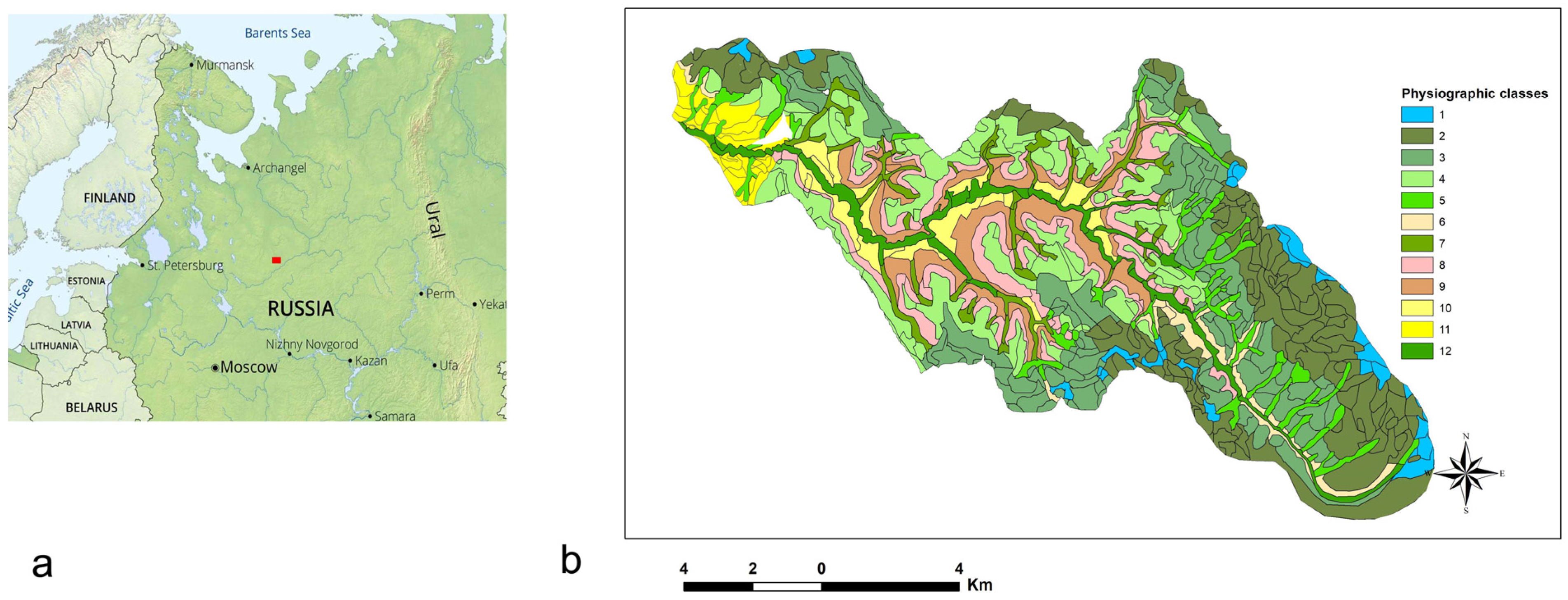
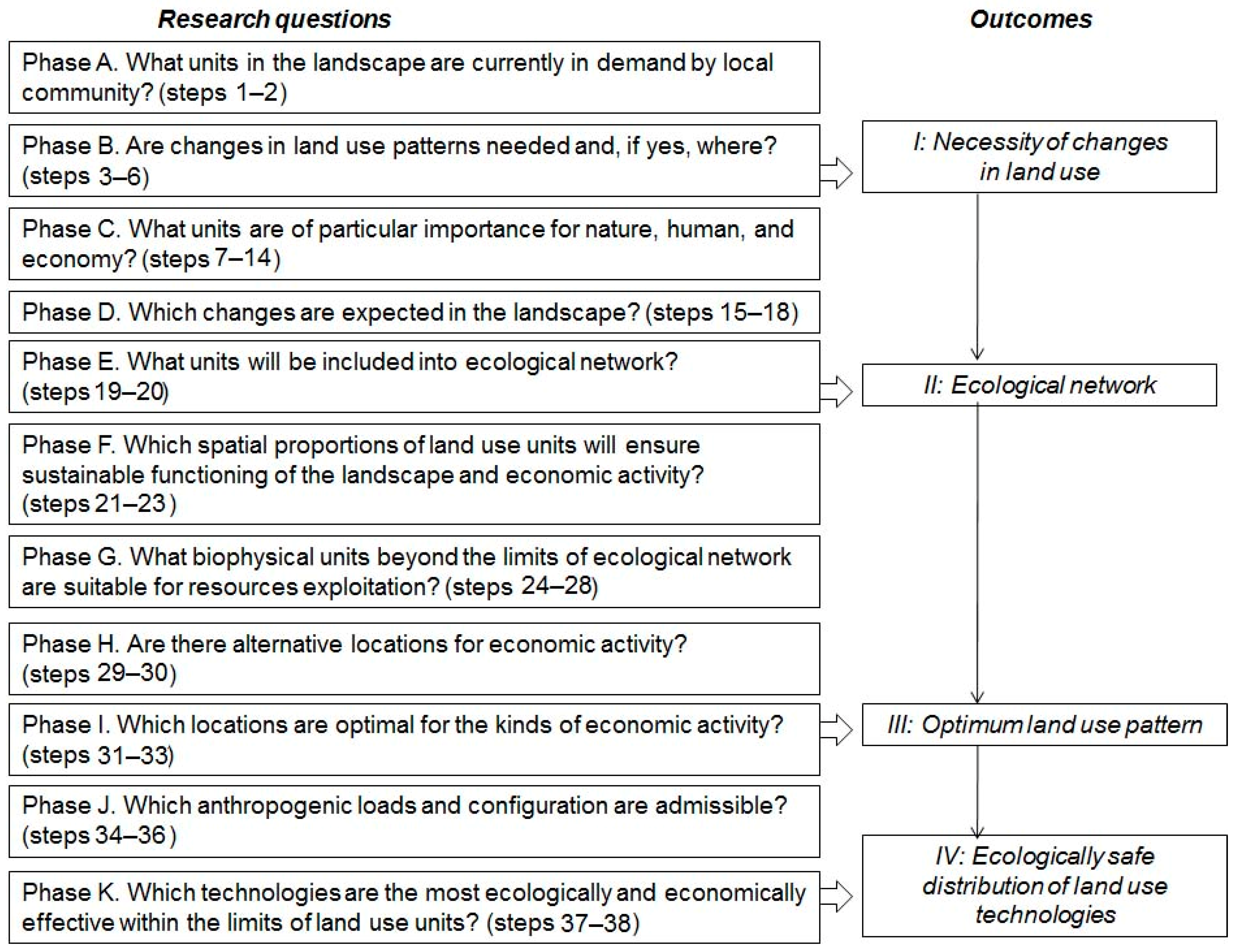
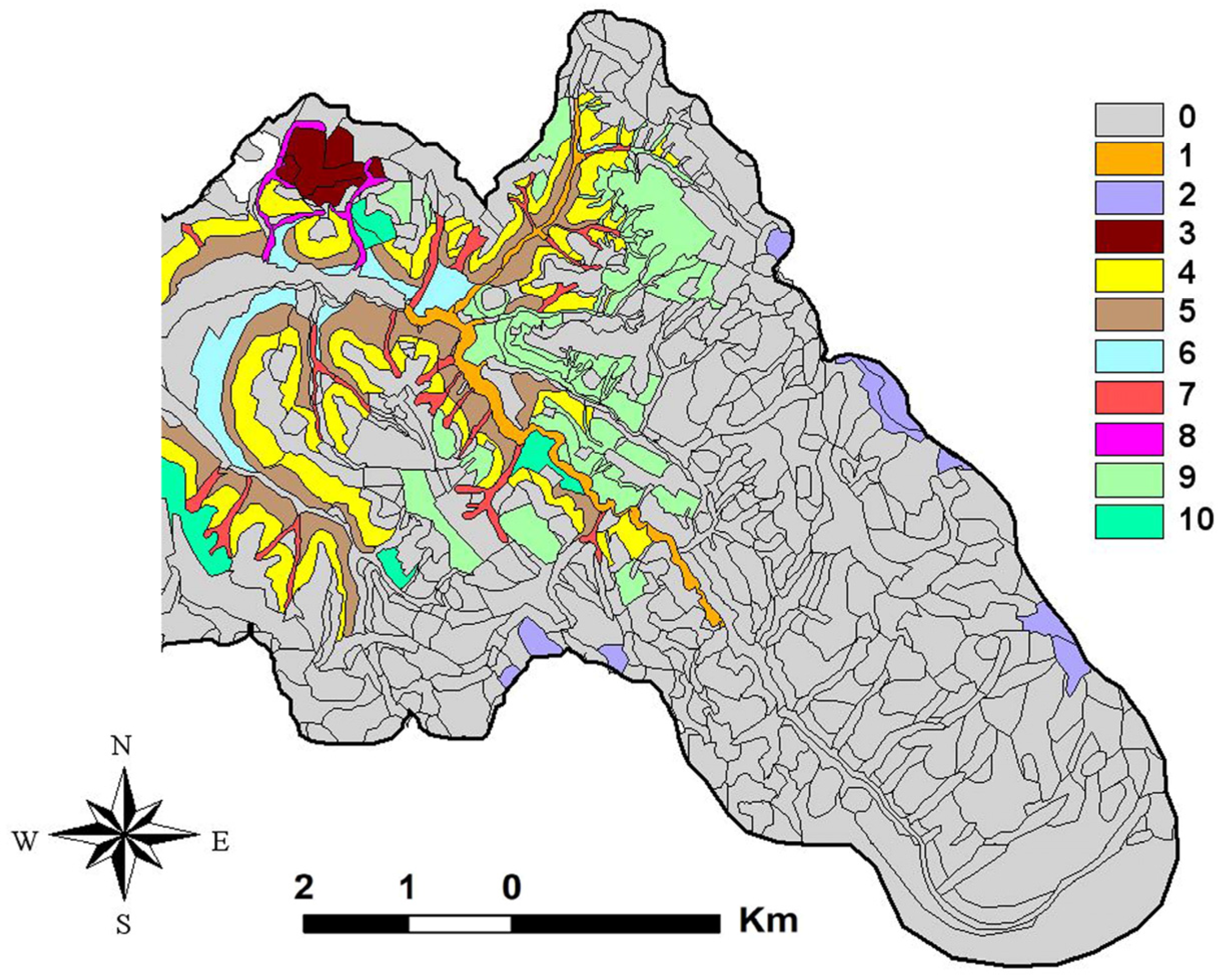
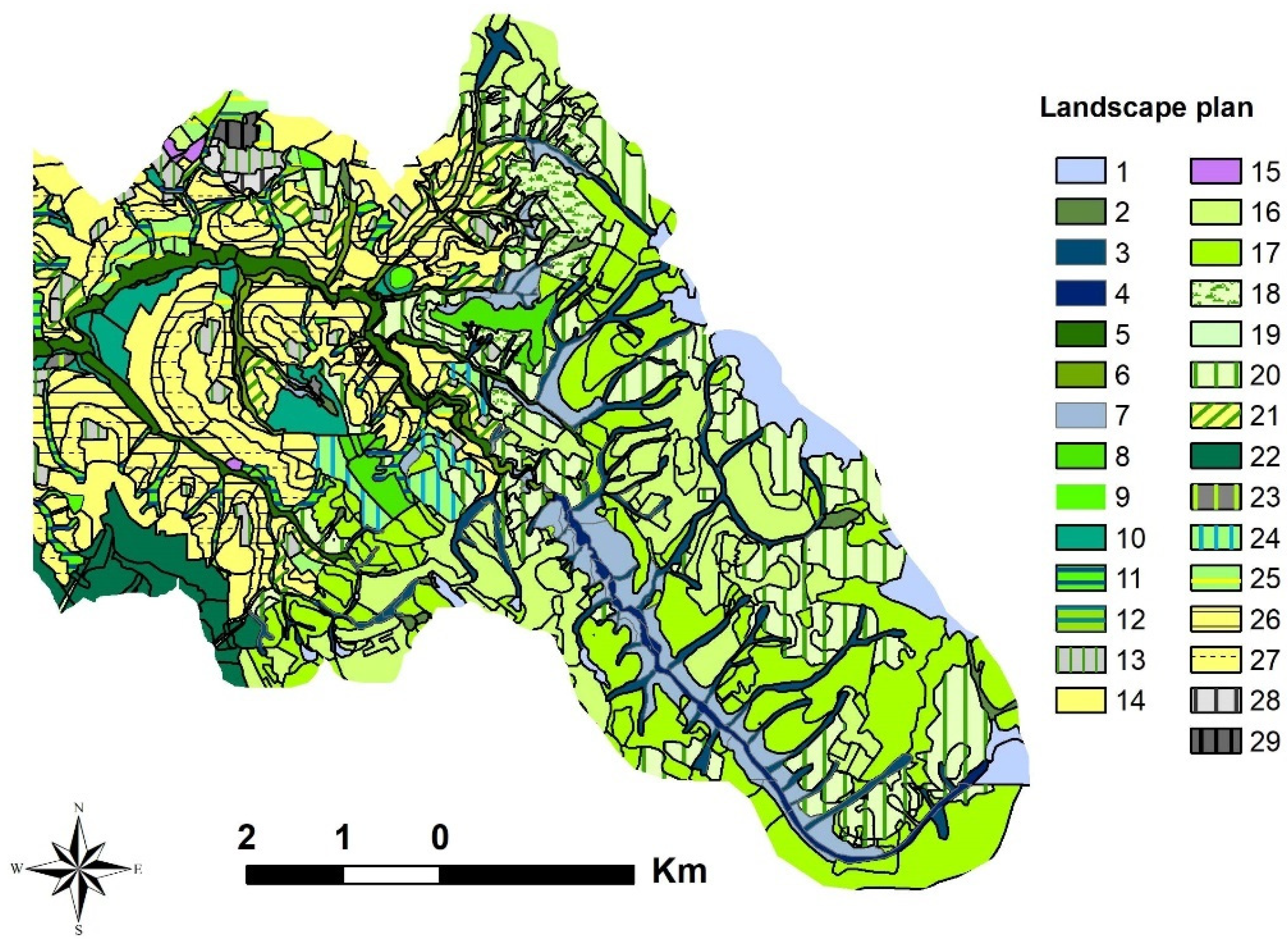
Table 1.
Recommended adaptations of agricultural land use to landscape pattern.
| Priority for Plowing | Landscape Units | Soil Quality and Drainage | Optimum Land Units |
|---|---|---|---|
| 1 | Edge well-drained sections of the flat or slightly convex interfluves with loamy Anthri-Rhendsic Leptosols, Anthric Umbrisols or Anthri-Umbric Albeluvisols. | Highly fertile for the taiga zone. High content of humus and exchangeable base cations. Perfect drainage. | Priority for grain crops. |
| 2 | Slightly inclined footslopes with loamy Anthri-Umbrisols. | High fertility due to accumulation of humus and nutrients washed out from the adjacent slopes. | Priority for grain crops. |
| 3 | Terraces with sandy Anthri-Albeluvisols and Anthri-Umbric Podzols. | Low humus and base cations content. | Vegetables (potatoes). |
| 4 | Flat interfluves with loamy-sandy Umbri-Gleyic Albeluvisols. | Poor drainage. Elevated acidity. Low content of base cations and humus. Land reclamation required. | Priority for annual fodder grasses. Bear hunt on specially cultivated small oats fields. Rangelands. Hayfields. Suitable for the construction building zone. |
| 5 | Steep valley slopes with eroded Anthri-Rhendsic Leptosols Anthri-Umbrisols alternating with exposures of marls. | Low humus content. High spatial variability of soil properties. Good drainage and heat supply on south-facing slopes. | Hayfields. Limited plowing parallel to contour lines with priority for perennial fodder grasses. |
| 5 | Remote sections of interfluves with loamy-sandy Umbri-Gleyic Albeluvisols. | Poor drainage. High acidity. Low content of humus, nutrients, and base cations. Low accessibility. | Natural afforestation or rangelands. |
Table 2.
Principles of allocating objects and recommended land use technologies in non-optimum or ecologically sensitive landscape units.
Table 2.
Principles of allocating objects and recommended land use technologies in non-optimum or ecologically sensitive landscape units.
| Land Use Type (30SE) | Landscape Unit (31SS) | Requirements for Allocation and Configuration (34FS, 35SD, 36SE, 37FD) | Recommended Technologies (38SE) |
|---|---|---|---|
| Road construction | Valley slope | Choose the section that is the least suitable for plowing. Cross at diagonal direction to reduce risk of road erosion and shrinkage of neighboring land use units. | Build silt fences and sediment traps along the ditches to prevent siltation of rivers. Re-establish vegetative cover at the ditch slopes to ensure soil stabilization. |
| Floodplain | Select the narrowest section and cross by perpendicular to minimize detriment to ecological corridor and habitats. | Ensure the least possible earthwork at the wettest sites. Exclude unnecessary dams to enable water and animals’ migration. | |
| Construction building | Sandy terrace | Avoid close adjacency to the stream; preference sections with wide floodplain between terrace and stream. | Intercept polluted water and avoid their infiltration to soil and groundwater. |
| Interfluve | Avoid shallow depressions collecting drainage runoff to exclude dispersion of pollutants downstream. Choose the areas with the disturbed soils that are no longer suitable for plowing. | Avoid chemical pollution of close to surface groundwater. | |
| Arable land | Gentle slope | Orient the longest side of a field along the contour lines to reduce soil erosion. | Establish crop rotation with prolonged cover by perennials. Orient the tillage direction along the contour lines. |
| Footslope | Separate land parcel on a footslope (if wide enough) from that on a terrace. | In case a footslope fully overlie a terrace, preserve the widest possible meadow or forest strip between the edge of a field and a floodplain. | |
| Terrace with sandy soils | Orient a field along the edge of a terrace. | Allow row crops with low nutrients demand. | |
| Cutting | Valley slope | Orient a cutover parallel to contour lines to reduce surface runoff. | Prefer hand felling to minimize a mechanical load on a soil. |
| Gullies | Avoid felling in gullies to preserve diversity of habitats and normal runoff or, if impossible, orient a cutover perpendicular to a stream. | Exclude timber transportation along gullies to prevent stream pollution and disturbance of habitats. |
Disclaimer/Publisher’s Note: The statements, opinions and data contained in all publications are solely those of the individual author(s) and contributor(s) and not of MDPI and/or the editor(s). MDPI and/or the editor(s) disclaim responsibility for any injury to people or property resulting from any ideas, methods, instructions or products referred to in the content. |
© 2024 by the authors. Licensee MDPI, Basel, Switzerland. This article is an open access article distributed under the terms and conditions of the Creative Commons Attribution (CC BY) license (https://creativecommons.org/licenses/by/4.0/).
Share and Cite
MDPI and ACS Style
Khoroshev, A.V.; Emelyanova, L.G. Nature-Based Solutions in Spatial Planning: How to Adapt Land Use to Natural Heterogeneity in Agroforest Landscapes in Russia. Land 2024, 13, 529. https://doi.org/10.3390/land13040529
AMA Style
Khoroshev AV, Emelyanova LG. Nature-Based Solutions in Spatial Planning: How to Adapt Land Use to Natural Heterogeneity in Agroforest Landscapes in Russia. Land. 2024; 13(4):529. https://doi.org/10.3390/land13040529
Chicago/Turabian StyleKhoroshev, Alexander V., and Lyudmila G. Emelyanova. 2024. "Nature-Based Solutions in Spatial Planning: How to Adapt Land Use to Natural Heterogeneity in Agroforest Landscapes in Russia" Land 13, no. 4: 529. https://doi.org/10.3390/land13040529
Note that from the first issue of 2016, this journal uses article numbers instead of page numbers. See further details here.