Abstract
Carbon emissions and land use intensity serve as crucial indicators of land management. This paper proposes a methodological framework to elucidate the sustainability of carbon emissions in rural areas via a coordination model, scrutinizes the correlation with land use intensity, and investigates the significance of influential factors. The study focuses on village-level units within Ningde City, and finds the pronounced spatial heterogeneity characterizing the distribution of carbon emissions across different villages: (1) Villages exhibiting high levels of carbon emissions are predominantly concentrated in the southeast region, whereas those with low carbon emission levels are primarily clustered in the northwest region. The majority of the villages serve as net carbon emission sources. (2) Spatial disparities exist in the impact of land use intensity on economic benefits from carbon sources, ecological benefits from carbon sinks, and carbon emission sustainability. (3) Significant variations exist in the influence of factors affecting land use intensity, economic benefits of carbon sources, ecological benefits of carbon sinks, and the sustainability of carbon emissions in rural areas. These findings could guide governments in implementing distinct land use control policies and provide a framework for assessing carbon emission sustainability within land management strategies.
1. Introduction
Since the beginning of the 21st century, China has experienced rapid urbanization and industrialization, catalyzing a profound transformation and spatial reconfiguration of land use [1]. Land, as a fundamental component of human production, supports nearly all human activities [2]. Variations in its utilization patterns and structural composition mirror shifts in spatial organization and industrial frameworks [3]. Concurrently, land use changes—most notably, the extensive conversion of agricultural territories into built environments—have diminished carbon sink areas while enlarging carbon source zones, thereby instigating shifts in carbon sources and carbon sinks [4], which in turn markedly influence the carbon equilibrium. The carbon emissions caused by this land use change are characterized as land use carbon emissions [5]. Economic development will inevitably lead to changes in land use types [6]. A sustainable land use paradigm requires the harmonious progression of land use and carbon emissions [7]. Consequently, investigating carbon emissions and sequestration in the context of land use, as well as delineating the carbon emission profile associated with various land use types, holds substantial directive value for regional planning and development. The rural setting, as the fundamental unit of rural social and economic development, represents a significant focal point for land use change [8]. As a grassroots administrative district, the land use decisions made in rural settings are intrinsically linked to the effectiveness of higher-level policy implementation [9]. Scientific inquiry into the inherent interconnection between rural carbon emissions and land use, coupled with the pursuit of synergistic strategies for judicious land resource management and the reduction in rural carbon emissions, is pivotal for advancing the fundamental attainment of carbon neutrality objectives [10]. This approach can serve as a critical juncture and an indispensable pathway, carrying significant theoretical and pragmatic implications.
Considering the diversity of land types, it is challenging for a single land category to simultaneously yield high economic and ecological returns. For instance, construction land typically offers substantial economic advantages while contributing minimally to ecological welfare [11]; conversely, grasslands, wetlands, and forestlands are often associated with greater ecological value but lower economic yield [12]. This highlights an inherent trade-off between economic prosperity and ecological vitality. A sustainable land use model should ensure the comprehensive development of various components, including economic and ecological aspects. Imbalances in the trade-offs between ecological and economic considerations can lead to significant changes in land use and cover [13], potentially resulting in irrational land development [14]. Carbon emissions from land use are a critical metric for assessing the sustainability of land use practices [15]. Moreover, the connection between regional land use carbon emissions and the socioeconomic framework may be influenced by the arrangement of land use [7]. In recent years, scholars from around the globe have extensively investigated total carbon emissions, their trends, and the driving factors of land use across various scales and methodologies. While most research has delineated the linear correlation between carbon emissions and socioeconomic progression [16], there remains a paucity of studies examining land use through the lens of the interplay between economic and ecological benefits derived from land-based carbon emissions. Sustainable carbon emissions refer to a land use paradigm where the economic and ecological benefits from carbon outputs are harmoniously aligned [7]. A disparity in the eco-economic advantages derived from land use carbon emissions may signal an illogical land use configuration [17], potentially impeding the progress towards carbon emission mitigation and low-carbon growth [17]. Such a scenario would make carbon emissions unsustainable [18]. Investigating the interrelationship between these factors and evaluating the equilibrium and synergy between them is not only a crucial method for achieving sustainable low-carbon development but also helps refine the land use framework.
Land use encompasses not merely the human utilization of land but also the intensity of such use, particularly the extent of disturbance inflicted upon the land [19]. Both the mode and intensity of land use critically influence the efficiency of land resource utilization and the environmental quality [20]. Land use intensity refers to the degree to which human activities affect natural ecosystems [21]. Land use intensity is a pivotal metric for assessing the sustainability of land use, reflecting regional economic and social development levels, as well as the efficiency of land resource allocation [22]. There exists a robust relationship between land use intensity and carbon emissions from land use. Different levels of land use intensity yield varying impacts on carbon emissions, thereby influencing global climate change and environmental quality [23,24]. However, the intricate relationship between land use, carbon emissions, and land use intensity remains partially obscured. The specific impact of land use intensity on carbon emissions from land necessitates further investigation [24,25]. Studies often provide recommendations based on either singular land use carbon emission outcomes or land use intensity metrics. Regional land planning and management should be based on a detailed and holistic analysis of the relationships between land use and carbon emissions, as well as impact factors, to ensure the sustainable utilization of land resources [26]. Exploring the fundamental connection between land use intensity and regional total factor carbon emissions can reveal inefficiencies in current land use practices, thus providing strong policy support for land management. Therefore, an analysis that comprehensively accounts for the interplay between land use carbon emissions and land use intensity is imperative and necessitates reinforcement [27].
To address the identified gaps and conduct a comprehensive examination of land use carbon emissions components, this study provides an in-depth analysis of rural carbon emissions and land use in Ningde City. It adopts a perspective centered on land use typology and intensity to identify inefficiencies in prevailing land use practices. Initially, the carbon emission coefficient method and the land use intensity coefficient method are used to quantify rural carbon emissions and land use intensity. The economic and ecological impacts of carbon emissions are assessed using metrics such as carbon emissions, carbon sequestration, and regional GDP. A coupled coordination model is then utilized to scrutinize the coordination relationship between the economic and ecological rewards of carbon emissions, thereby assessing the sustainability of such emissions. Subsequently, the local entropy method is utilized to analyze the spatial dynamics between land use intensity and carbon emissions, aiming to identify spatial disparities in the relationship between carbon emissions and land use intensity. Ultimately, the study explores the key factors influencing carbon emissions and land use intensity through the utilization of the random forest algorithm. The insights derived from this inquiry are poised to make a significant contribution to the dialogue surrounding sustainable low-carbon development and guide the recalibration of land use paradigms in rural settings.
2. Materials and Methods
2.1. Data
The data sources of land use, energy consumption, and economic statistics are shown in Table 1.

Table 1.
Data and sources.
2.2. Research Framework
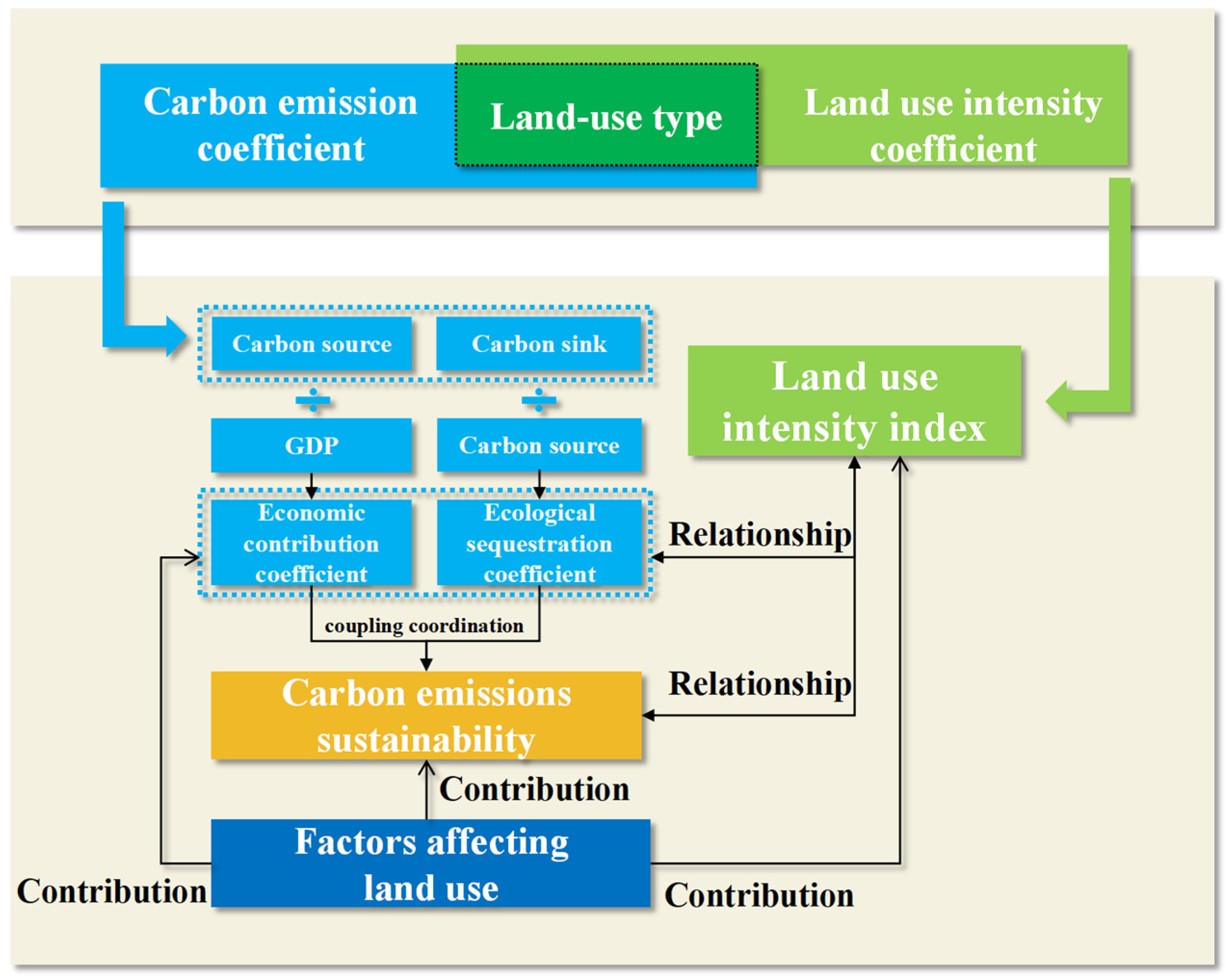
As depicted in Figure 1, this article presents a research framework meticulously crafted for the comprehensive analysis of rural carbon emissions and their correlation with land use intensity. Initially, we utilized the carbon emission coefficient method and the land use intensity coefficient method to quantify rural carbon emissions (carbon source and sink) and land use intensity. We employed spatial clustering and hotspot analysis to delineate their spatial distribution characteristics and discern underlying patterns. This approach facilitates the identification of current imbalances in the spatial distribution of carbon emissions and land use intensity, pinpointing locations in urgent need of improvement. Subsequently, we established economic benefit assessment indicators for carbon emissions using socioeconomic metrics (regional GDP), and ecological benefit assessment indicators based on the interaction between carbon emissions and absorption. The coupled coordination model was then applied to evaluate the sustainability of carbon emissions by examining the synergy between their economic and ecological benefits. This analysis helps identify inefficiencies in rural carbon emission practices and highlights areas that need immediate improvement to promote sustainable carbon emission development. Furthermore, local entropy diagrams were used to meticulously examine the spatial correlation between land use carbon emissions and land use intensity. This analysis highlighted critical interactions and identified inefficiencies in current land use practices, delineating areas that need improvements to promote sustainable development. Finally, the random forest algorithm was utilized to determine the significance of various factors influencing land use indicators. This critical analysis reveals vital insights that propel the sustainable development of land use forward, guided by the discernible influence of specific impact factors on land use practices and carbon emissions.

Figure 1.
Research framework.
2.3. Study Area
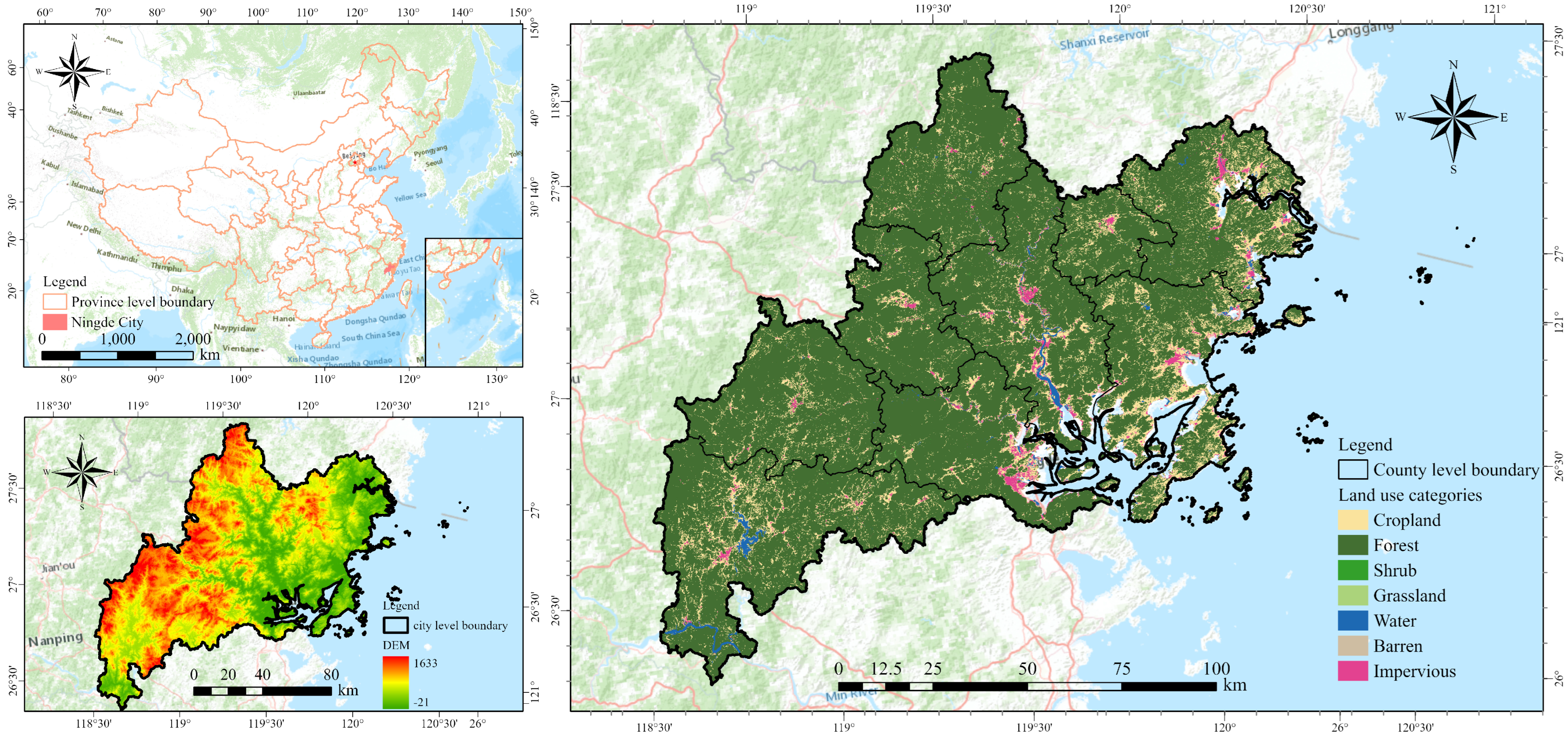
As depicted in Figure 2, Ningde City is situated in the northeastern segment of Fujian Province, overseeing an administrative division that includes nine counties, cities, and districts. Quintessentially coastal, Ningde lies on the southeastern seaboard of China, an area distinguished by its diverse topography of mountains, seas, rivers, islands, and lakes. The city boasts a wealth of natural resources and ecological treasures. Its eastern coastal stretch is marked by an extensive, serpentine coastline peppered with numerous harbors, while the coastal beaches are interspersed, their distribution influenced by the rugged terrain. In stark contrast, the western region is defined by its undulating hills and mountainous terrain, with forests enveloping 68.73% of the landscape. This geographical mosaic has led to the local adage that Ningde is a land of “nine mountains, half water, and half farmland”, encapsulating the city’s unique physical composition. This study evaluates different carbon emission metrics and land use intensity by utilizing villages in China as the fundamental research units, which are equivalent to rural settings in this context.
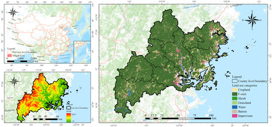
Figure 2.
Introduction to the study area.
2.4. Research Methods
2.4.1. Carbon Emissions Calculation
Carbon emissions from rural land use can be broadly divided into two categories: direct and indirect emissions. The former is directly linked to alterations in land use. As such, this study has quantified direct carbon emissions across various types of land use. Drawing upon the classification standards of the international Land Use/Cover Change (LUCC) project and considering the unique characteristics of land resources in Fujian Province, land use in Ningde City has been categorized into seven types: cultivated cropland, forestland, grassland, wetland, water bodies, built-up construction land, and bare land.
Existing research suggests that the long-term carbon emissions from various land types, including cropland, garden land, woodland, grassland, wetland, water bodies, and bare land, have remained relatively stable [28,29]. Carbon emissions from these land types and other agricultural lands are computed by multiplying the area of each land type by its corresponding carbon emission coefficient. The carbon emission coefficients for different land types are as follows [28,29,30,31]:
- Cropland: 0.464 hm−2∙a−1
- Garden land: −2.451 hm−2∙a−1
- Forest land: −5.052 hm−2∙a−1
- Grassland: −0.947 hm−2∙a−1
- Wetland: −0.41 hm−2∙a−1
- Water body: −0.25 hm−2∙a−1
- Bare land: −0.005 hm−2∙a−1
Carbon emissions from other agricultural lands are primarily derived from livestock farming (including cattle, sheep, pigs, poultry, etc.) and human activities. According to Eggleston’s research, the carbon emission coefficient for other agricultural lands is 0.95 t/a [32].
The formula for calculating carbon emissions from land use is based on the area of the land use type. The calculation formula for land use carbon emissions, which takes into account the area of the land use type and its carbon emission coefficient, is as follows:
In Formula (1), Ci represents the carbon emissions of the i-th land use type (ton); Si represents the area of the i-th land use type (hm2); and Vi represents the carbon emission coefficient of the i-th land use type (ton/hm2/year).
The carbon emissions of rural construction land are mainly calculated through indirect carbon emissions. The carbon emissions of construction land are calculated based on the energy consumption and land use data of Ningde City in 2021. Carbon emissions from village construction land mainly include green space, fossil energy consumption, electricity consumption, and population breathing carbon emissions. The formula for calculating carbon emissions from rural construction land is:
In Formula (2), Ccon is the total carbon emissions of village construction land (ton); Cg represents the carbon emissions of green space (ton). Most of the green space consists of landscaped trees and grassland. Therefore, the carbon emission coefficient of green space should fall between that of woodland/forest and grassland. Since it is not possible to obtain the specific planting ratio, the average of the two values (−3.001) can be taken as the carbon emission coefficient of the green space [33]. Cene represents the carbon and electricity consumption emissions of fossil energy consumption in the village (ton). Since the fossil energy consumption of enterprises in village-level units does not directly benefit village-level administrative units, the study uses the village-level permanent population multiplied by the per capita living energy consumption to calculate the construction land fossil carbon emissions from energy consumption and electricity consumption. Cpeo represents the respiratory carbon emissions of the village population (ton), calculated based on the emission of 0.9 kg of CO2 per person per day, which is equivalent to 0.2455 kg of carbon [34]. The carbon emissions from village fossil energy consumption and electricity usage are primarily derived indirectly by calculating the total carbon emissions produced from energy consumption in human life, in conjunction with various existing methods for calculating carbon emissions from fossil energy consumption [35]. The calculation formula is as follows:
In Formula (3), Cene represents the total carbon emissions from various types of fossil energy consumption (ton), where i is the energy type, mi is the per capita consumption of energy i, p is the village population, and ni is the conversion standard coal coefficient of energy i; φi, the carbon emission factor, is the standard coal coefficient, which is equal to the product of the average low calorific value, carbon content, and oxidation rate of various energy sources; and 44/12 is the ratio of carbon dioxide molecular weight to carbon. The calculation of carbon emission coefficients and standard coal conversion coefficients for each energy type is based on the “IPCC National Greenhouse Gas Inventory Guidelines”, “General Principles for Comprehensive Energy Consumption Calculation (GB/T2589-2020)”, and “Provincial Greenhouse Gas Inventory Preparation Guidelines” [33,34,36]. The calculated carbon emission coefficients for each energy source and the corresponding standard coal coefficient values are presented in Table 2 below. The per capita consumption of different energy types in Fujian Province in 2021 is presented in Table 3 below.
Table 2.
Energy carbon emission coefficient and converted standard coal coefficient.
Table 3.
Household energy consumption per capita in Fujian Province in 2021.
Finally, the study compiled the carbon emissions from different land types in each village-level administrative unit in Ningde City to assess whether each unit is a net source (emitting more than it sequesters) or a net sink (sequestering more than it emits).
2.4.2. The Calculation of Land Use Intensity (LUI)
Land Use Intensity (LUI) is a measure of the degree to which human activities disrupt land use in a specific region at a given time [37]. It serves as a mirror, reflecting not only the inherent characteristics of various land use types but also the extent of human land use. This reflection provides insights into how the equilibrium of land resources is maintained within the human social system [38]. In practical scenarios, a single sample area often comprises a mix of different land use types. Each type occupies a distinct proportion of the area and contributes to the LUI based on its individual influence weight. According to the research [35], the LUI is calculated using a specific formula:
is the comprehensive index of LUI; is the area of land use type i in the sample area (km2); is the land use in the sample area and the land use intensity coefficient of type i; is the total area of the sample area (km2); n is the number of land use types included in the sample area; and 100 is to amplify the coefficient 100 times. According to the characteristics of the study area and previous research results and experience, the intensity coefficients assigned to different land use types vary. This study adopts the method of [39] and assigns values to the LUI of various types based on the degree of human activity interference on land use (Table 4), with values ranging from 0 to 9. Among these, unused land is challenging to use for social and economic activities, experiences minimal human interference, has little input and output, and is assigned a value of 0. Woodland, forestland, and grassland have carbon sequestration functions and can only be developed with restrictions, and are assigned values of 4 and 3, respectively. Water bodies have relatively lower development intensity and are assigned a value of 2. Cultivated land, or cropland, has dual socioeconomic and natural attributes, serving as both a carbon source and sink and is assigned a value of 7. Garden land also possesses dual socioeconomic and natural attributes, with stronger carbon sink capabilities. The value assigned to the built-up construction land is 6 because it accommodates a large number of human social and economic activities, making it the type of land that generates carbon emissions on the mainland. Green space, a special type of developed land, accommodates various human leisure and recreational activities and is a crucial land category for carbon sequestration, assigned a value of 8. This enables a more accurate assessment of land use.
Table 4.
Intensity coefficients of land use types.
2.4.3. Analysis of the Spatial Distribution of Carbon Emission Levels
This study employs hetero-clustering and outlier analysis (Anselin Local Moran’s I) as well as the local spatial autocorrelation index (Getis–Ord General Gi*) to examine the spatial distribution characteristics of carbon emissions in villages in Ningde City. The local spatial autocorrelation index can analyze the specific locations of spatial agglomeration, identifying hot spots and cold spots in the spatial layout of the plot [40]. If Gi*Z is significantly positive, it indicates the presence of high-value spatial aggregation, suggesting the existence of hot spots. Conversely, if it is significantly negative, it indicates the presence of low-value spatial aggregation, suggesting the existence of cold spots. This method can identify where villages with high carbon emissions and villages with low carbon emissions are concentrated. Clustering and outlier analysis can identify significant spatial outliers by using the local Moran index statistic to analyze weighted features [41]. This method can identify the spatial features that are adjacent to or surrounded by different elements: a circle of low values surrounds a high value, while conversely, a circle of high values surrounds a low value. With this method, the spatial adjacency of low and high carbon emissions values in each village can be detected.
2.4.4. Measurement of Carbon Source Economic Efficiency and Carbon Sink Ecological Sink Efficiency
The economic contribution coefficient of the carbon source and the ecological carrying coefficient of the carbon sink are used to represent the socioeconomic benefits of the carbon source and the ecological benefits of the carbon sink [42]. The economic contribution coefficient (ECC) of carbon sources can be used to evaluate the fairness of the economic contribution of carbon emissions between different regions. It is one of the indicators that reflects the productivity of carbon emissions in each region. It is calculated as follows:
Gi and G are, respectively, the GDP of the i-th grid and the total regional GDP (billion yuan); C_i and C are, respectively, the total carbon emissions of the i-th grid and the total regional carbon emissions (ton). If ECCi > 1, it means that the economic contribution rate of the i-th grid is higher than the contribution rate of land use carbon emissions, indicating that the economic efficiency of carbon emissions from this grid is higher; if ECCi < 1, it means that the i-th grid carbon emissions are less economically efficient.
The Ecological Sequestration Coefficient (ESC) offers a valuable metric for evaluating the fairness of various regions’ contributions to carbon sequestration and uptake. It serves as an indicator of regional carbon sink capacity. The calculation formula is as follows:
CA and CAi are the total carbon absorption in the region and the carbon absorption by the main carbon sink of the i-th grid, respectively (ton). If ESCi > 1, that is, the contribution rate of the main carbon sink of the i-th grid to carbon absorption is higher than the contribution rate of carbon emissions, it will have a positive impact on carbon emission reduction; conversely, it will have a negative impact on carbon emission reduction.
2.4.5. Land Use Carbon Emissions Sustainability Assessment (CESI)
Land use carbon emission sustainability (CESI) refers to the ability to meet current regional carbon neutrality needs during the carbon emission process without compromising the local capacity to support its own economic development [43,44,45]. The quantitative assessment of land use carbon emissions’ sustainability primarily involves analyzing the balance between the contribution of carbon emissions to economic development and the land resource system’s capacity to absorb and transport carbon. Based on this theoretical concept, we calculated the spatial coupling strength of the ECC of carbon sources and the ESC of carbon sinks and used the coupling coordination strength of the two to characterize the level of the land use carbon emission sustainability index (CESI).
The coupling coordination degree is a model used to analyze the level of coordinated development of entities [46]. The coupling degree refers to the interaction between two or more systems and the dynamic correlation that enables coordinated development. It reflects the degree of interdependence and mutual constraints between systems. This can be used to analyze the coordination relationship between two or more elements. The degree of coordination refers to the level of harmonious coupling in the interaction relationship, which reflects the quality of the coordination situation. In this study, the coupling degree refers to the correlation between the economic benefits obtained from carbon sources and the ecological benefits of carbon sinks. The formula for calculating the coupling coordination degree of carbon source and sink benefits is:
In the formula, C is the coupling degree, ranging from 0 to 1; U1 and U2 represent the comprehensive scores of carbon source benefit and carbon sink benefit, respectively. A higher comprehensive score correlates with increased economic and ecological advantages of carbon emissions. The larger the C value, the closer they are to benign resonance coupling, and the system tends to a new ordered structure; the smaller the C value, the smaller the degree of interaction between the two, and the system tends to a disordered state. The calculation formula for coupling coordination degree is as follows:
In the formula, DCESI is the land use carbon emission sustainability index (CESI), based on the coupling coordination degree; T is the comprehensive evaluation index of carbon source benefit and carbon sink benefit; and α and β are both undetermined coefficients. Since the carbon source benefit and carbon sink benefit are equally important, α = β = 0.5. In this study, the greater the T value, the more harmonious the interplay between the economic and ecological benefits.
2.4.6. Analysis of the Relationship between Land Use Intensity and Carbon Emissions
The study utilizes the binary mapping function of ArcGIS (10.6) software to analyze the clustering of high and low values for LUI and ECC, LUI and ESC, and LUI and CESI. At the same time, local binary relationships are utilized to analyze the spatial distribution of the aforementioned three-pair-two variable local relationship types. Local binary relationships are a spatial statistical analysis method used to examine the relationship between two variables. This method utilizes local entropy to analyze two variables in order to obtain statistically significant relationships. The relationship between two variables can be spatially divided into six categories and explore how their relationship changes throughout the study area [47]. The study utilized this tool to assess the correlation between rural LUI and carbon emissions and to ascertain the consistency of these relationships across the study area.
Firstly, the Rényi entropy [48] of multivariate data (including dependent and independent variables) is calculated using the normalized minimum spanning tree (MST) length of each spatial unit. Secondly, the entropy value of each spatial unit under the null hypothesis is converted into a probability value (p-value) to create an empirical normal distribution using the permutation method. Thirdly, p-values are calculated using statistical tests [47] proposed by three critical significance values (Bonferroni, Bonferroni adjusted for spatial dependence, FDR) to be applied to entropy graphs in order to control the multiple comparison problem. The order of critical p-values from smallest to largest is FDR < Bonferroni adjusted for spatial dependence < Bonferroni < significance level (e.g., 0.05). Finally, a local entropy plot is generated using the p-value to explore the relationship between variables. Small p-values imply low uncertainty at the local scale and high confidence in strong relationships between variables. Therefore, we can choose research units whose p-values are within the Bonferroni interval to uncover significant relationships between variables. MST involves calculating the length; the application of local entropy maps requires specifying k (number of groups) and α (edge weight).
2.4.7. Importance Analysis of Factors Affecting Land Use
This paper utilizes a regression model based on the random forest algorithm to assess the impact of different land use influencing factors on carbon emissions and LSI [49]. The model uses land use influencing factors as independent variables and ECC, ESC, CESI, and LSI as dependent variables. The model’s results are calculated using the Gini coefficient to identify the variables with the highest importance scores. Variable importance can be utilized to identify significant variables for land use and to analyze the differences in contributions of influencing factors to carbon emissions and LSI in detail.
3. Results and Analysis
This study conducted a meticulous analysis of the spatial distribution of carbon emission intensity and land use intensity across villages. It quantified the economic and ecological benefits of carbon emissions for each village and assessed the sustainability of these emissions based on the interplay between the two benefits. Furthermore, the research examined the local spatial relationships and clustering patterns of the economic and ecological benefits of carbon emissions, as well as the sustainability of carbon emissions and land use intensity. Lastly, the study explored the disparate factors influencing these spatial relationships.
3.1. Spatial Distribution of Carbon Emission Levels
Figure 3 delineates the precise carbon emission intensity per unit area (tons/year/m2), derived from computations spanning 3374 village-level units. Of these, 2798 villages, or 82.92%, are net sources where emissions surpass sequestration. Conversely, 569 villages, or 16.86%, are net sinks where sequestration exceeds emissions. It is clear that the majority of villages in Ningde City are net sources of carbon emissions. A closer look reveals that villages with high carbon emissions are predominantly located in the southeastern districts and counties, notably Jiaocheng District, Fu’an City, Xiapu County, and Fuding City. On the other hand, villages with low carbon emissions are largely found in the northwestern districts and counties, particularly in Gutian County, Pingnan County, Zhouning County, and Shouning County. Coastal regions within Ningde City are observed to exhibit lower carbon emission intensity. Overall, it is evident that there is a significant spatial disparity in carbon emission intensity across the city, highlighting diverse environmental impacts and variations in land use efficiency.
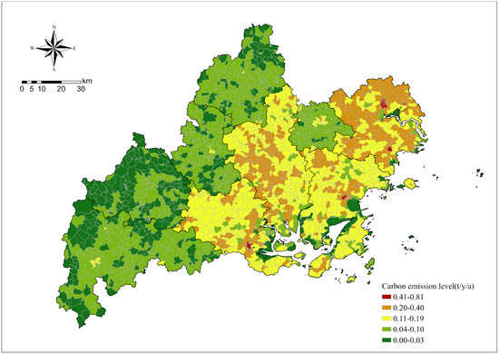
Figure 3.
Carbon emission levels in various villages in Ningde City.
Figure 4 provides a visual representation of the carbon emission levels across various village-level units in Ningde City. The northwest region of Ningde City primarily comprises ‘cold spots’ of carbon emissions, indicating lower emission levels. In contrast, the southeast region is characterized by ‘hotspots’ of carbon emissions, signifying higher emission levels. This spatial distribution suggests that villages with elevated carbon emissions are predominantly situated in the southeastern counties and districts of Ningde City, including Jiaocheng District, Fu’an City, Xiapu County, and Fuding City. On the other hand, villages with reduced emission levels are largely located in the northwestern counties of Ningde City, such as Gutian County, Pingnan County, Zhouning County, and Shouning County. Notably, only a handful of villages along the southeastern coast exhibit low carbon emission levels. The data clearly illustrate distinct spatial variations in rural carbon emission levels within Ningde City, with a trend of higher emission levels in the southeast and lower levels in the northwest. The findings further underscore the significant spatial heterogeneity in rural carbon emissions. This variability highlights the importance of developing tailored, region-specific strategies to effectively manage and reduce carbon emissions. These strategies should consider the distinct environmental and socioeconomic contexts of each area.
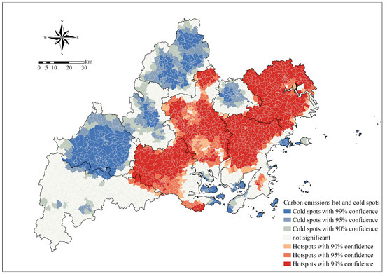
Figure 4.
Hot and cold spots in rural carbon emission levels.
Figure 5 presents the spatial clustering and outlier analysis results of carbon emissions at the village level in Ningde City. This analysis is capable of identifying outliers in both hot and cold spots, thereby producing optimizable spatial results. The term ‘high-high clustering’ refers to the phenomenon where villages with high carbon emissions are grouped together. Conversely, ‘low-low clustering’ denotes the grouping of villages with low carbon emissions. ‘High-low clustering’ suggests a scenario where high carbon-emitting villages are surrounded by low carbon-emitting ones. On the other hand, ‘low-high clustering’ indicates that low carbon-emitting villages are encircled by high carbon-emitting ones. Villages with high carbon emissions are predominantly concentrated in the southeast, forming a distinct spatial pattern where these high-emitting villages encircle those with lower emissions. Conversely, villages with low carbon emissions are primarily aggregated in the northwest, illustrating a clustering of low-emission villages. This spatial arrangement not only reveals a pattern where low-emission villages are interspersed among high-emission ones but also indicates a tendency for similar emission-level villages to cluster together. Such spatial clustering suggests the need for targeted carbon management strategies that consider the localized emission profiles.
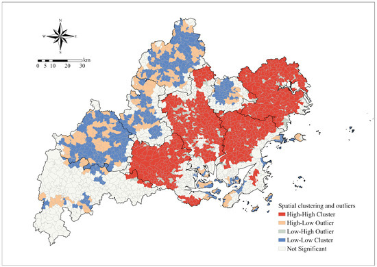
Figure 5.
High and low carbon emission clustering of village-level units.
3.2. Spatial Distribution of Land Use Intensity
Figure 6 illustrates the spatial distribution of rural land use intensity in Ningde City, with a majority of villages exhibiting medium-intensity land use. High-intensity land-use villages are scattered across Ningde City, predominantly in low-elevation districts and counties of significant political and economic importance. Conversely, villages with low land use intensity are primarily located along the coast. The rural settings exhibit marked disparities in land use intensity, reflecting a diverse array of land use patterns.

Figure 6.
Land use intensity of rural areas in Ningde City.
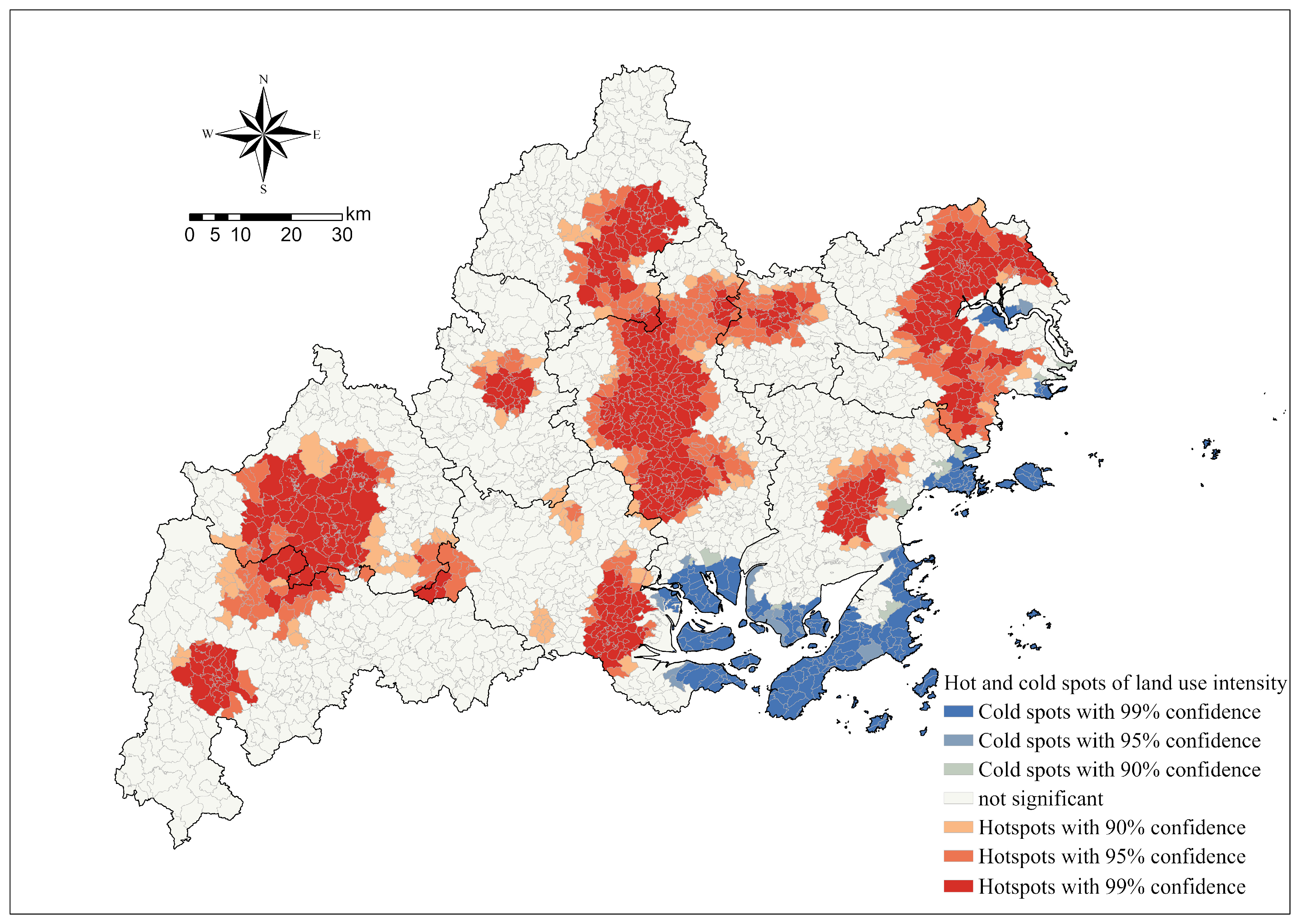
The study further investigates the regions of high and low rural land use intensity within Ningde City. The hot spots primarily consist of three core areas (Figure 7). Villages with high land use intensity are predominantly found in the central, eastern, and western regions, while cold spots are dispersed in the southeastern coastal area. An initial observation reveals a certain degree of mismatch in the spatial distribution of hot and cold spots concerning village land use, carbon emissions, and land use intensity. The observations reveal that in Ningde City, rural land use intensity exhibits a pronounced local clustering pattern, delineated by varying degrees of intensity.
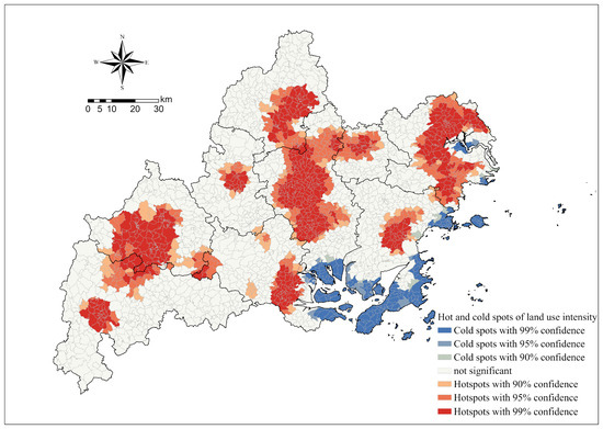
Figure 7.
Hot and cold spots of village-level LUI.
To optimize the results, the study conducts a spatial outlier analysis to identify outliers within the hot and cold spots. Villages with high land use intensity are primarily concentrated in the central, eastern, and western regions, which also include a few villages with low land use intensity (Figure 8). Villages with low land use intensity are mainly located on the southeastern coast. Interestingly, this location displays a spatial characteristic where a large number of low-intensity land-use villages are surrounded by high-intensity land-use villages, indicating significant variances in the land use intensity within this area. The findings not only elucidate the disparities in the spatial distribution of land use intensity but also reveal a tendency for villages with high land use intensity to aggregate within Ningde City. Conversely, villages with lower land use intensity exhibit a similar clustering pattern. This phenomenon underscores the polarized nature of land utilization within the region and suggests the presence of underlying factors influencing these patterns.
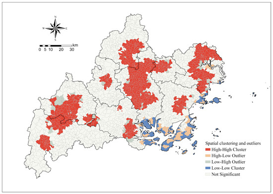
Figure 8.
Spatial outlier analysis of village-level LUI.
These findings align with the results from the hot and cold spot analysis of rural land use intensity, further demonstrating the spatial distribution disparities in rural land use intensity within Ningde City. The analysis also reveals an inconsistency between the spatial distribution of rural land use intensity and carbon emission levels in Ningde.
3.3. The ECC of Rural Carbon Sources and ESC of Rural Carbon Sinks
In Ningde City, the economic advantages of carbon sources in villages vary significantly, with values ranging from 0 to 18.031 and an average of 0.84. Notably, the majority of villages (83%) have economic benefits from carbon sources that are less than 1, suggesting a low level of carbon emission benefits. This trend is indicative of the overall low economic benefits derived from carbon sources in Ningde City (Figure 9). The findings indicate that carbon emissions in the majority of Ningde City’s villages do not yield optimal economic outcomes. Consequently, there is a pressing need to refine the prevailing patterns of rural land use to enhance economic productivity. Interestingly, villages with higher economic benefits from carbon sources are predominantly located in non-coastal areas of Ningde City. Despite the economic development often associated with coastal areas, the economic benefits of carbon sources at the village level in these regions remain relatively low. This pattern suggests that excessive carbon emissions may be a contributing factor to the diminished economic benefits of carbon sources.
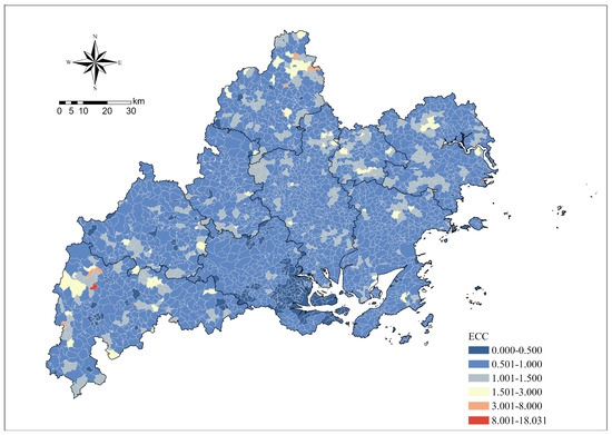
Figure 9.
ECC of rural carbon sources.
The carbon sink ecological benefits of villages also vary significantly, ranging from 0 to 65.102, with an average value of 1.29. A substantial number of villages, precisely 1499, have carbon sink ecological benefits of less than 1, constituting 44.42% of the total. Furthermore, the majority of villages exhibit carbon sink ecological benefits within the range of 1 to 3, suggesting that the overall carbon sink ecological benefits in Ningde City are relatively low (Figure 10). From a spatial standpoint, it is observed that villages with lower carbon sink ecological benefits tend to cluster into patches, exhibiting high connectivity. Conversely, villages with higher carbon sink ecological benefits demonstrate a similar pattern. This observation underscores the presence of distinct high and low spatial clustering of carbon sink ecological benefits across various villages in Ningde City, indicative of certain spatial disparities and patterns. The results demonstrate that numerous rural areas maintain a low carbon emission footprint; however, the ecological benefits derived from these emissions exhibit significant spatial variability. This underscores the need for region-specific approaches to optimize the ecological advantages of carbon management practices.

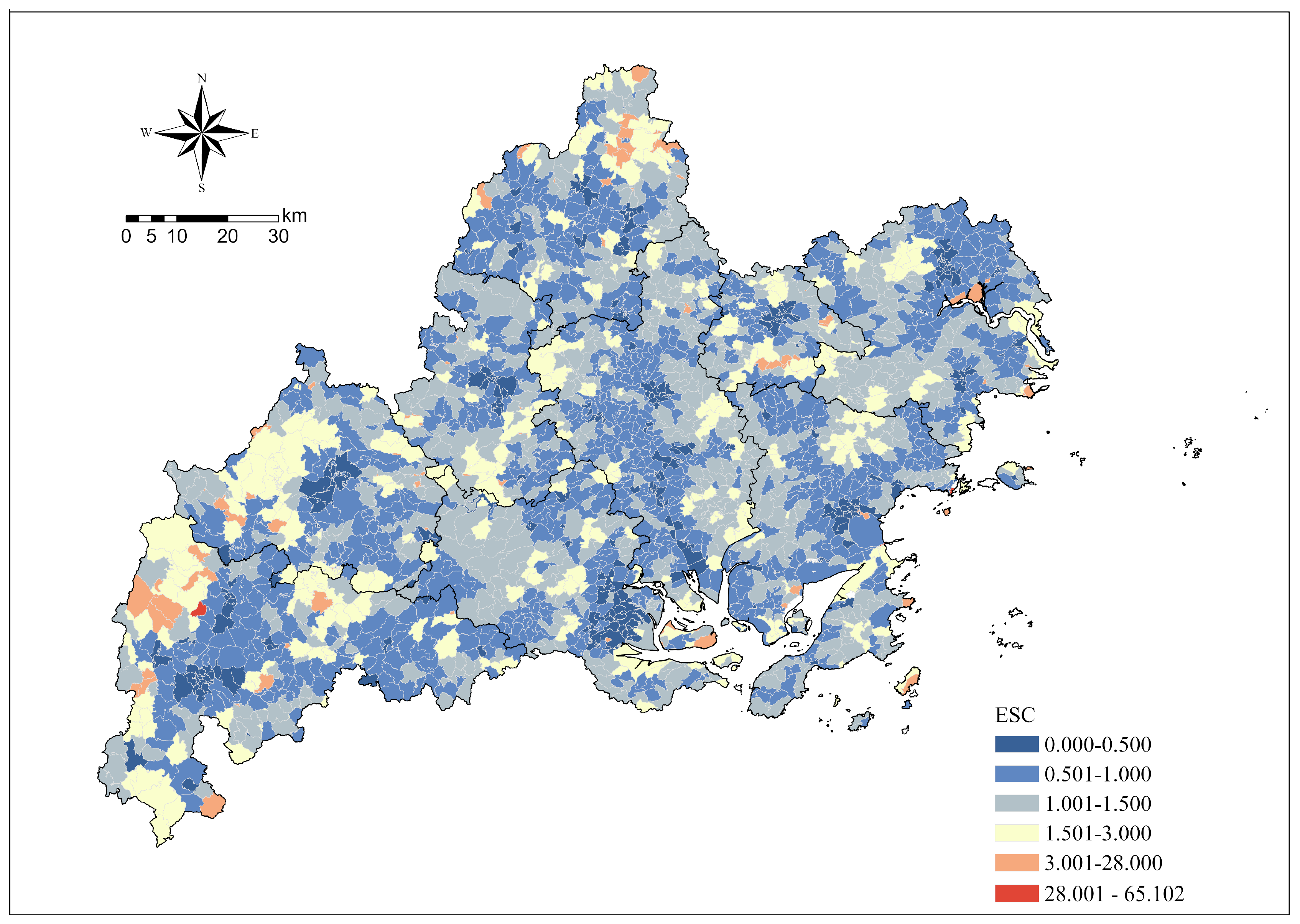
Figure 10.
ESC of rural carbon sink in Ningde City.
3.4. Carbon Emissions’ Sustainability
The economic benefits derived from carbon sources serve as a measure of the regional carbon emissions’ contribution to the economy, while the ecological benefits of carbon sinks reflect the contribution of regional carbon absorption. These two aspects form the core content of comprehensive carbon emissions. This study employs a coupled coordination model to analyze the interrelationship between the economic benefits of carbon sources and the ecological benefits of carbon sinks.
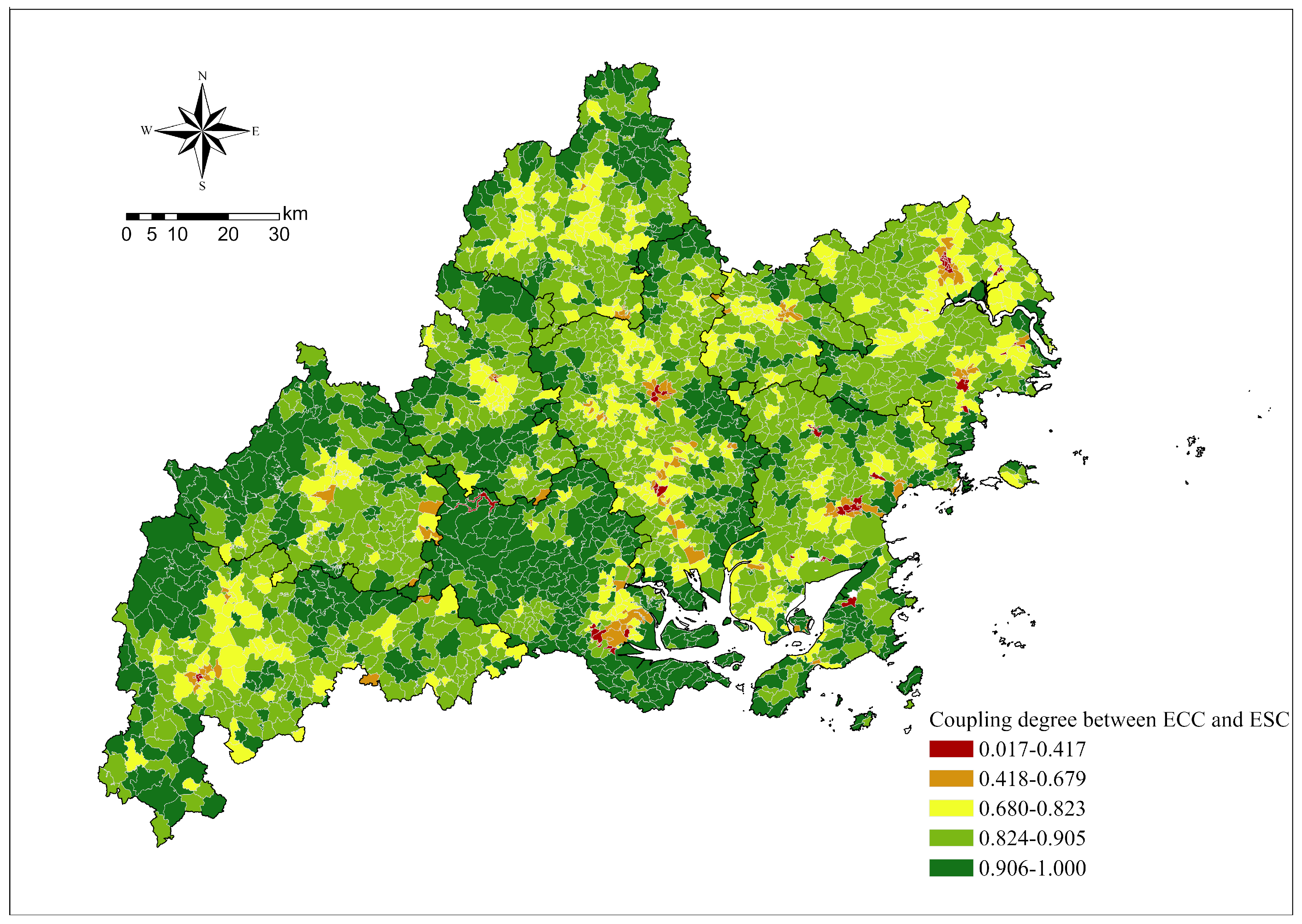
Figure 11 illustrates the degree of coupling between the economic benefits of carbon sources and the ecological benefits of carbon sinks in the villages of Ningde City. A smaller value indicates a weaker interaction between the two, while a larger value signifies a more pronounced interaction. The coupling degree of carbon source economic benefits and carbon sink ecological benefits in most villages is relatively high, suggesting a strong interaction between the two.

Figure 11.
Coupling degree of ECC of rural carbon sources and ESC of carbon sinks.
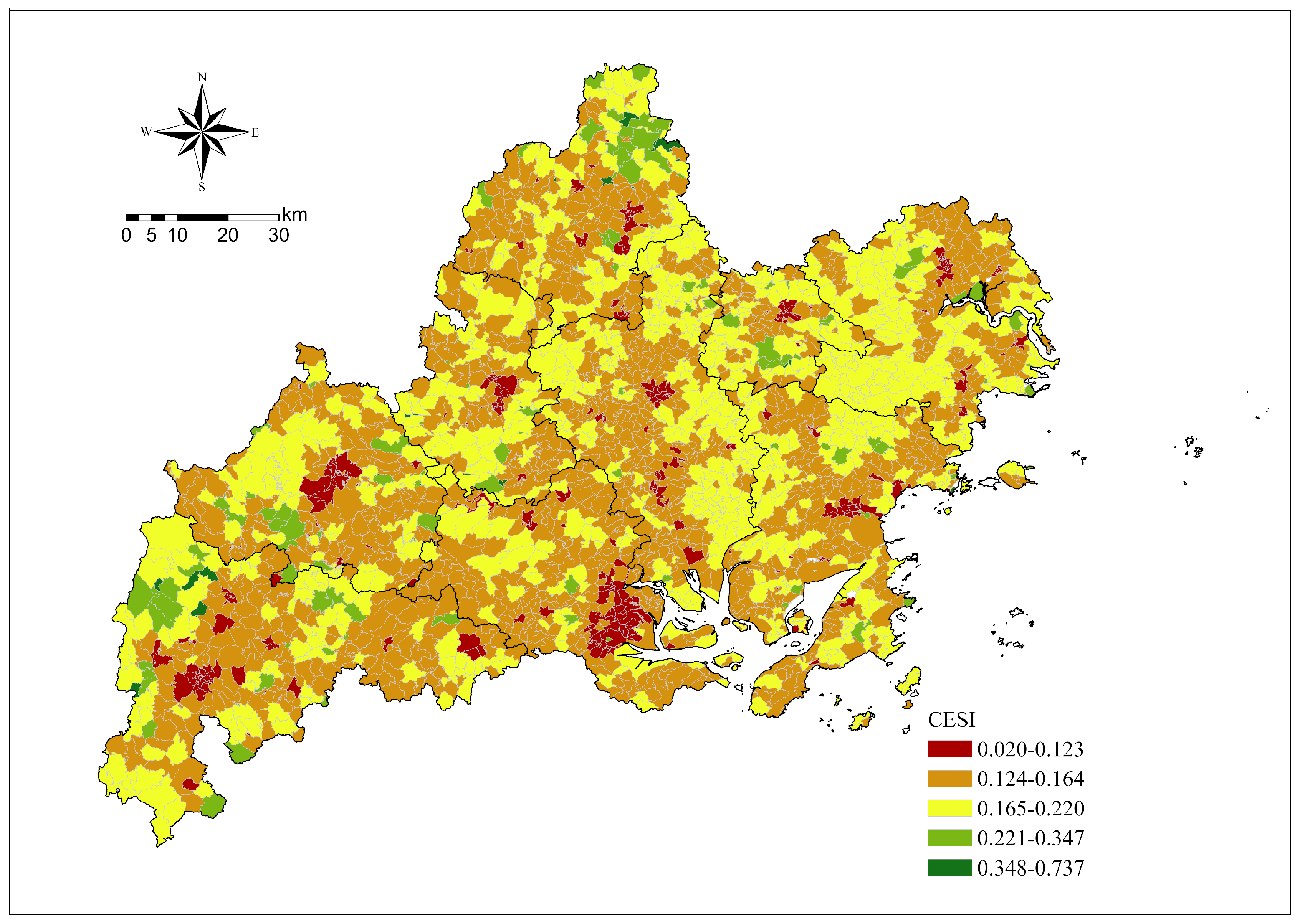
Figure 12 provides an analysis of the sustainability of rural carbon emissions in Ningde City. This is evaluated through the coordination value, which represents the balance between the economic benefits derived from carbon sources and the ecological benefits from carbon sinks. A higher coordination value signifies a greater level of sustainability in rural carbon emissions.

Figure 12.
Rural carbon emission sustainability index.
Existing research categorizes the results into four levels based on the coordination value:
- A value between 0 and 0.25 indicates a highly inconsistent relationship between the economic benefits of carbon sources and the ecological benefits of carbon sinks, suggesting extremely low sustainability of carbon emissions.
- A value between 0.25 and 0.5 also denotes a high level of inconsistency, indicating low sustainability of carbon emissions.
- A value between 0.5 and 0.75 represents a higher level of coordination, thus implying a higher sustainability of carbon emissions.
- A value between 0.75 and 1.00 signifies very high coordination, suggesting that highly coordinated carbon emissions are extremely detrimental to the environment.
The average carbon emission sustainability score for rural areas in Ningde City is 0.16. This suggests that the sustainability of carbon emissions in most villages is extremely low, with 2621 villages accounting for 96.3% of the total. This highlights the urgent need for improving carbon emission sustainability in most villages in Ningde City. From a spatial analysis standpoint, rural regions demonstrate a clustering effect predicated on the sustainability levels of their carbon emissions. Areas characterized by low sustainability in terms of carbon emissions show pronounced local clustering. In contrast, regions with low carbon emission sustainability are sparsely distributed, predominantly in the northwest, indicating substantial spatial disparities and distinct patterns.
3.5. Relationships between Carbon Emissions and Land Use Intensity
Land use intensity, a reflection of human activity levels in a region, impacts carbon emissions from the land. Evaluating its effect on carbon emission efficiency can guide the optimization of Ningde’s land use structure. A generalized linear regression model was employed in this study to determine the relationship between land use intensity and the economic benefits of carbon sources. The coefficient of land use intensity was found to be −0.016, with both the probability and robust probability (Robust_Pr) indicating statistical significance (p < 0.01). This suggests a significant relationship between land use intensity and the economic benefits of carbon source emissions.
A local binary relationship model was utilized to analyze the spatial distribution of the strength and types of relationships between land use intensity and the economic benefits of carbon source emissions. A lower entropy value indicates a stronger relationship between the two variables (Figure 13). The average entropy is 0.6461, suggesting an unstable relationship between the two variables. The analysis revealed that 3 villages exhibit positive linearity (0.11%), 77 villages show negative linearity (2.77%), 31 villages display a concave function (1.127%), and 17 villages present a convex function (2.77%). Additionally, 45 villages (1.62%) have undefined complex relationships. Villages exhibiting significant relational typologies are predominantly situated in the northwest of Ningde City, notably within Pingnan County and Gutian County. It is observed that, in most rural locales, there is no discernible correlation between the economic benefits of carbon emissions and the intensity of land use. This lack of a clear relationship suggests the complexity of factors at play in rural carbon economics and land management practices.
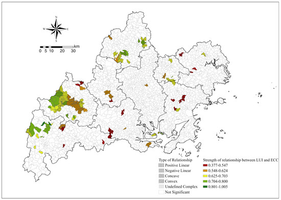
Figure 13.
Relationship between ECC and LUI.
This study delves into the clustering patterns of land use intensity and the economic benefits derived from carbon sources. Land use intensity is demarcated by a threshold value of 4.5, distinguishing between high and low intensities. The economic advantage of carbon sourcing is bifurcated using a value of 1 as the demarcation line between high and low benefits. Figure 14 illustrates that a majority of villages, totalling 1444 or 52.79%, display high land use intensity coupled with low economic gains from carbon sources. Conversely, 243 villages, making up 8.88%, demonstrate high land use intensity alongside substantial economic benefits from carbon sources. Out of the total village count, 819 (29.94%) exhibit both low land use intensity and low economic benefits from carbon sources. A subset of 229 villages, representing 8.37% of the total, exhibit low land use intensity but yield significant economic benefits from carbon sources. A notable spatial agglomeration phenomenon is observed in Ningde City, where most villages display high land use intensity and low economic benefits from carbon sources. This pattern is particularly prominent in Pingnan County, Fu’an City, and Fuding City. Interestingly, low land use intensity and a reduced carbon footprint also lead to a certain degree of spatial aggregation, which in turn results in economic benefits. This implies that in most villages within Ningde City, land use carbon emissions do not translate into substantial economic benefits. Instead, they reflect a land use paradigm that lacks strategic economic planning, suggesting the need for a reassessment of land management practices to align with economic objectives.
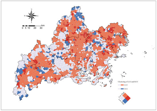
Figure 14.
Clustering of ECC and land use intensity.
The generalized linear regression results reveal a coefficient of −0.207 for land use intensity. Both the probability and robust probability (Robust_Pr) stand at 0.031, indicating statistical significance (p < 0.01). This underscores a significant correlation between land use intensity and the ecological benefits of carbon sinks. Figure 15 portrays the local binary relationship, with an average entropy of 0.5917 and an average p-value of 0.1144, signifying a robust relationship. Among the villages, 35 (1.25%) exhibit a positive linear trend, 1062 (37.97%) show a negative linear trend, 179 (6.40%) display a concave function, and 245 (8.78%) present a convex function. A total of 302 villages (10.80%) have undefined replication relationships, accounting for 8.76% of the total. It is observed that in Ningde City’s rural areas, land use intensity primarily exhibits a negative correlation with the ecological benefits of carbon sinks. These areas are predominantly located in the central regions of Pingnan County, Jiaocheng District, Fu’an City, and Fuding City. It reveals a robust correlation between the ecological advantages derived from rural carbon emissions and the intensity of land use within Ningde City.
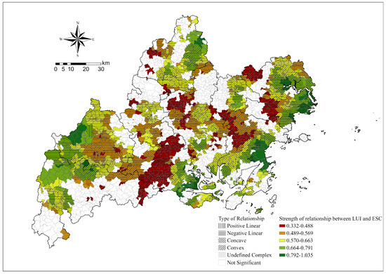
Figure 15.
Relationship between ESC and LUI.
Figure 16 illustrates the diverse degrees of land use intensity and the corresponding ecological benefits of carbon sequestration. A total of 537 villages (19.66%) demonstrate high land use intensity and significant carbon sink ecological benefits. Conversely, 358 villages (13.1%) show low land use intensity and low carbon sink ecological benefits. Out of the total number of villages, 695 (25.44%) exhibit low land use intensity and high carbon sink ecological benefits, while 1141 villages (41.77%) display high land use intensity and low carbon sink ecological benefits. Most villages in Ningde City exhibit a clustering of low land use intensity and high carbon sink ecological benefits, as well as high land use intensity and low carbon sink ecological benefits. This is accompanied by a noticeable spatial aggregation phenomenon, particularly evident in Pingnan County, Gutian County, Xiapu County, Fu’an City, and Fuding City. High land use intensity and high carbon sink ecological benefits are associated with a certain degree of spatial aggregation phenomenon, dispersed across various districts and counties. The findings suggest a marked dissonance between the ecological benefits associated with rural carbon emissions and the intensity of rural land use, implying that current land use practices may undermine carbon sequestration efforts.

Figure 16.
High and low clustering of ESC and land use intensity.
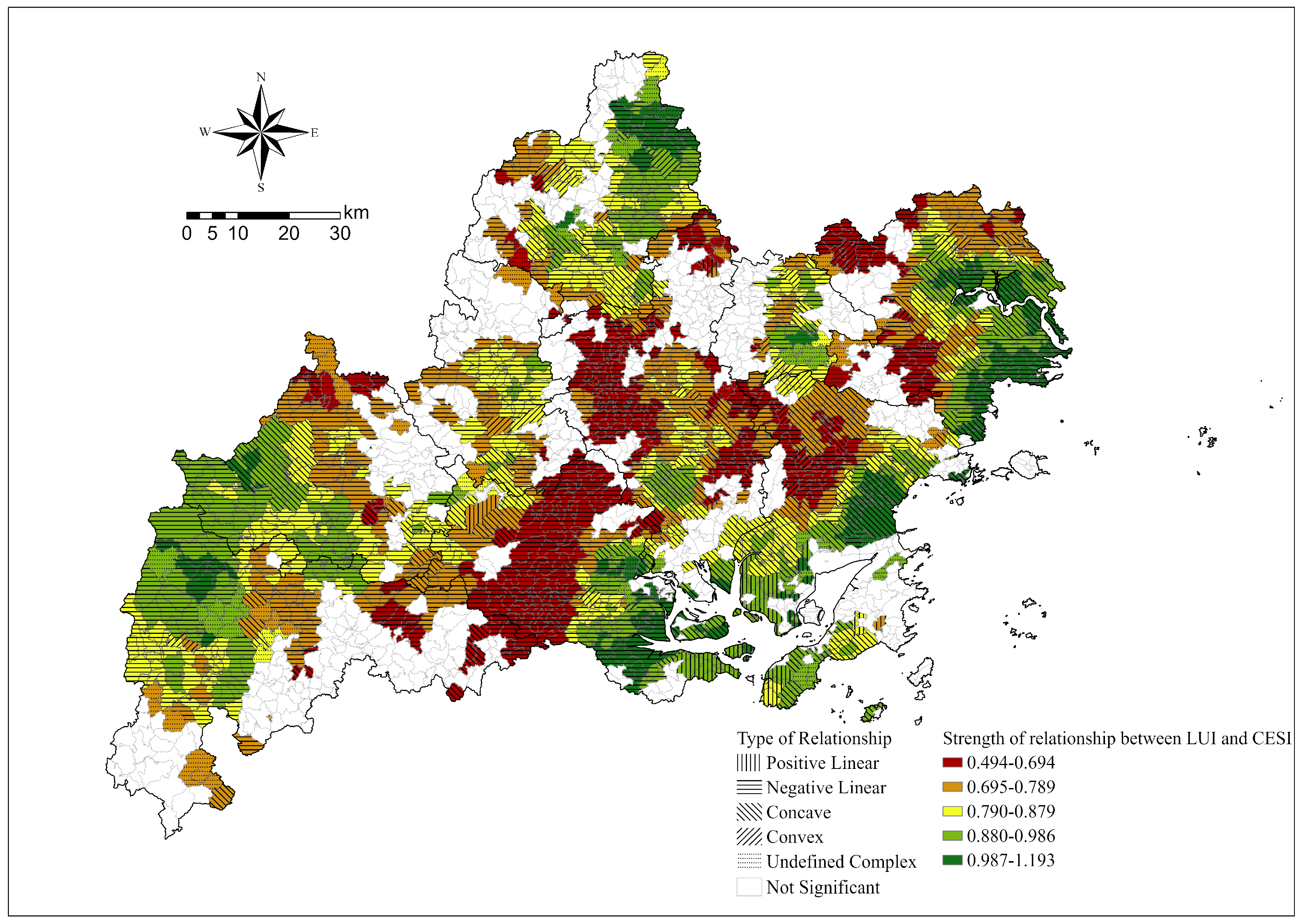
The generalized linear regression results reveal a significant negative correlation between land use intensity and carbon source and sink benefits, with a coefficient of −0.016 (p < 0.01). This relationship is further illustrated in Figure 17, which depicts the local binary relationship. The average entropy and p-value are 0.7209 and 0.0762, respectively, indicating a strong correlation. In terms of village distribution, 18.26% (616 villages) exhibit positive linearity, 10.17% (343 villages) show negative linearity, 6.55% (221 villages) display a concave function, and 21.99% (742 villages) present a convex function. Additionally, 20.87% (704 villages) have undefined replication relationships. The analysis reveals that in Ningde City’s rural areas, land use intensity is primarily negatively correlated with carbon emission sustainability. These areas are predominantly located in the western and central regions of Ningde City, specifically in Pingnan County, Jiaocheng District, Gutian County, and Fu’an City, among others. Furthermore, a number of villages with complex relationships are mainly concentrated in the southeast of Ningde City. This analysis demonstrates a significant correlation between the sustainability of rural carbon emissions and land use intensity in Ningde City. Notably, the precise nature of this relationship exhibits substantial spatial heterogeneity.

Figure 17.
Relationship between LUI and CESI.
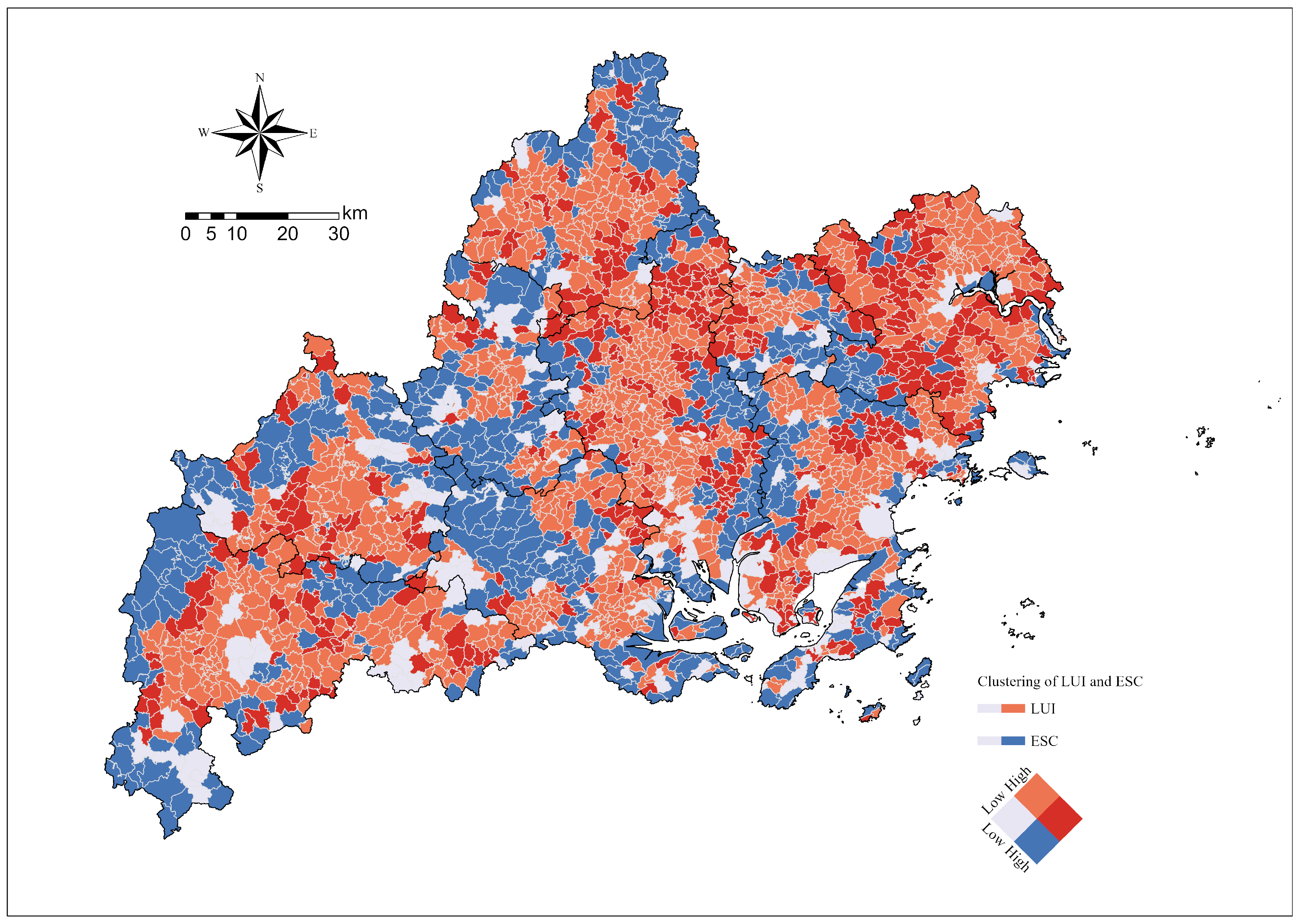
Figure 18 further illustrates the varying degrees of land use intensity and carbon emission sustainability across villages. Only one village exhibits high land use intensity and high sustainability, while 38.33% (1043 villages) demonstrate low land use intensity and low sustainability. Only four villages exhibit both low land use intensity and high sustainability. However, a significant 61.48% (1673 villages) display high land use intensity and low sustainability. Most villages in Ningde City are characterized by high land use intensity and low carbon emission sustainability (Figure 18). Some clusters, however, show low land use intensity and low carbon emission sustainability. These clusters appear in distinct patches, indicating a spatial aggregation phenomenon. The evidence points to a pronounced conflict between the sustainability of rural carbon emissions and the intensity of land use. Present land use practices appear to impede the sustainable trajectory of carbon emissions, underscoring a critical need for numerous rural regions to reformulate their land use configurations and carbon emission strategies.
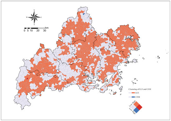
Figure 18.
High and low clustering of CESI and land use intensity.
3.6. Analysis of Factors Affecting Land Use
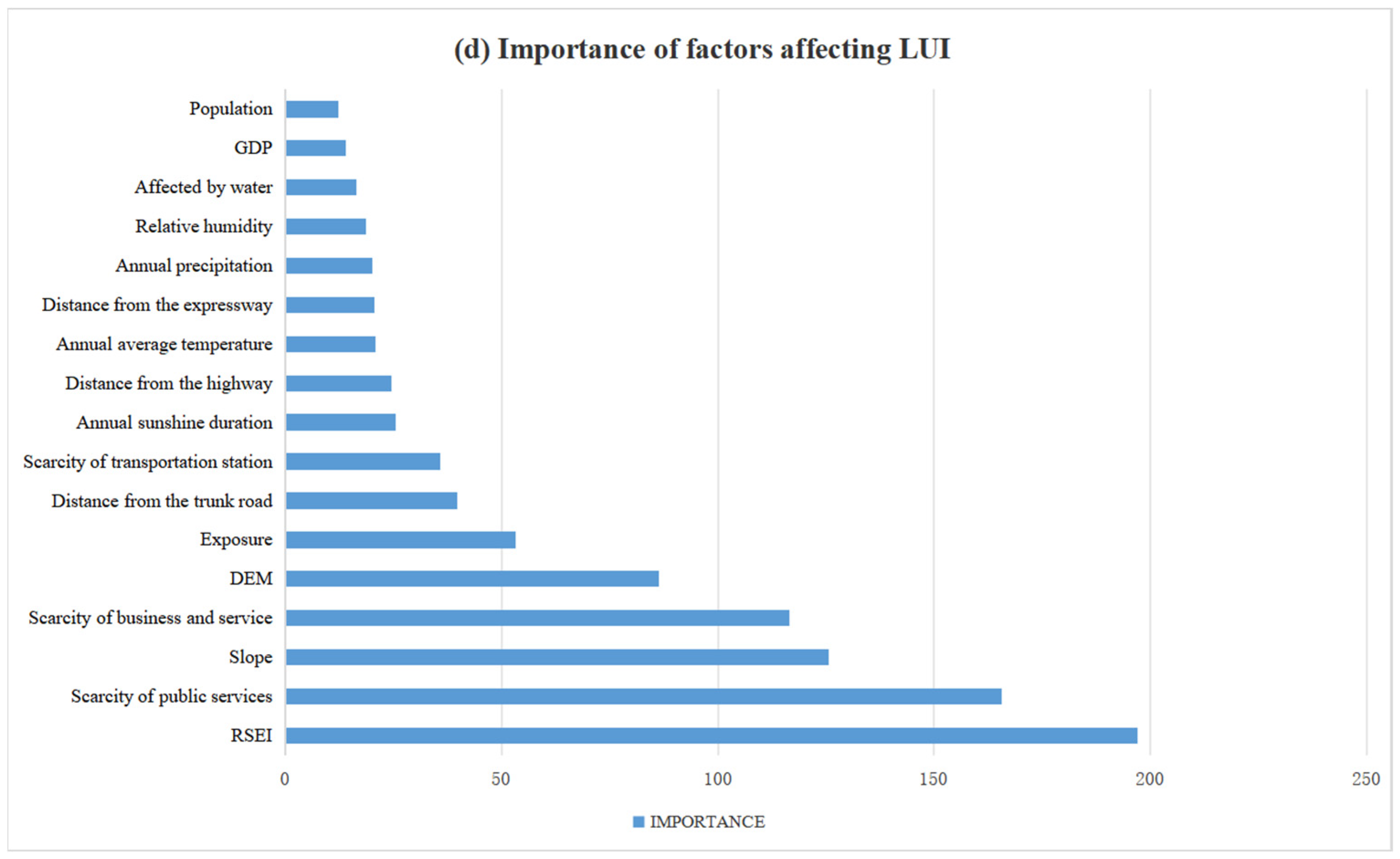
Land use carbon emissions are influenced by a myriad of factors, which can be broadly classified into natural and socioeconomic categories. The study employed the random forest algorithm to assess the varying impacts of determinants on the nexus between carbon emissions and land use. This yielded a hierarchical ranking of the significance of each influence on land use, with a higher degree of importance indicating a more substantial impact. Figure 19 illustrates how changes in land use, driven by factors such as population, GDP, sunshine duration, and precipitation, predominantly affect the economic benefits of carbon sources in Ningde City’s rural areas. Conversely, the ecological benefits of carbon sinks are mainly shaped by population, GDP, the presence of expressways, and the quality of the ecological environment. The sustainability of carbon emissions hinges primarily on population size, the quality of the ecological environment, GDP, and the terrain’s slope. The intensity of land use is largely dictated by the quality of the ecological environment, the proximity to public facilities, the terrain’s slope, and the distance to commercial logistics hubs. It is worth noting that the impact of these land use influencing factors varies across different evaluation indicators. This necessitates that, in the quest to reconcile the dichotomy between land use and carbon emissions, it is imperative to discern the disparities in primary influencing factors by delineating specific relationships.
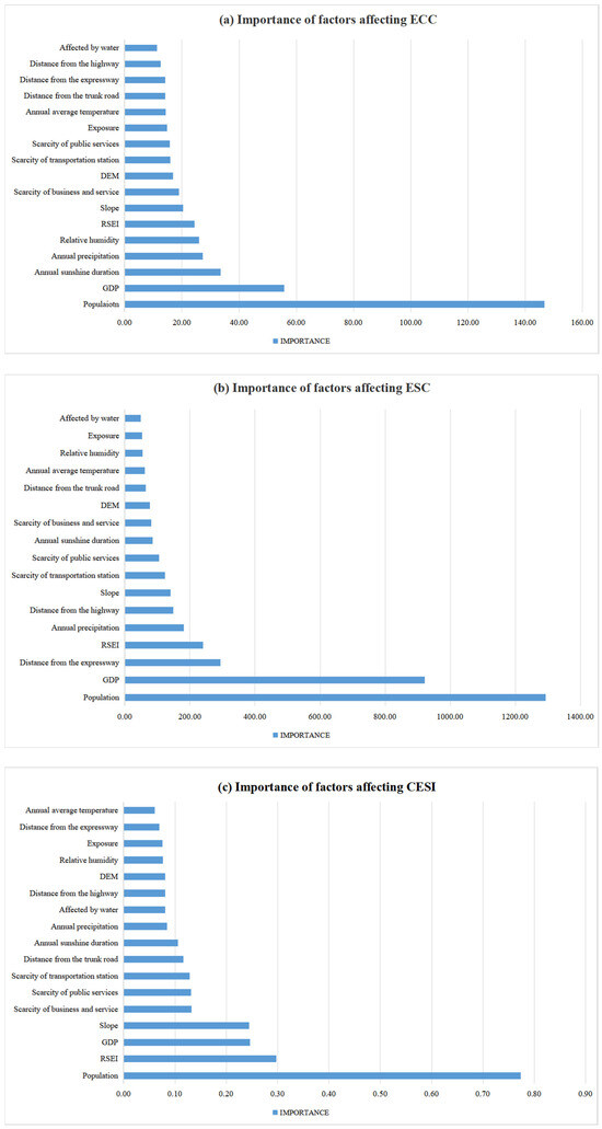
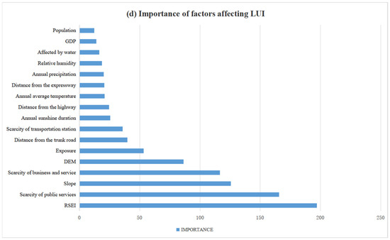
Figure 19.
Natural and socioeconomic factors affecting land use.
4. Discussion
4.1. Harmonizing Land Use and Carbon Emissions
The research findings underscore distinct variances in carbon emissions, land use intensity, and their interrelation across different villages. It is this very recognition of spatial disparities that informs the tailored approach, proving to be efficacious for the development of diverse regions. In terms of the economic benefits of carbon sources, increased land use intensity may lead to an increase in carbon emissions, but its contribution to economic development is relatively inadequate. In terms of the ecological benefits of carbon sinks, higher land use intensity may result in increased carbon emissions, but the land ecosystem cannot tolerate excessive increases in carbon emissions. If this intensity increases excessively, it will cause damage to the local ecosystem. Increased land use intensity may lead to an imbalance between economic development and ecosystem protection in terms of sustainable land carbon emissions. Coordinating the mutually reinforcing relationship between land use intensity and economic development, ecosystem protection, and carbon emission sustainability is not only the most effective way to preserve land resources for lasting and effective utilization but also to ensure the stable development of ecosystems. Measuring the intensity of land use cannot be directly used as a basis for determining whether land use is reasonable. When assessing the reasonableness of land use, carbon emission sustainability is the most crucial and scientifically sound indicator for measurement and evaluation. It is essential to research and establish a scientific and rational land management mechanism, implement a land-saving model, optimize and enhance the overall land use structure and distribution layout, improve the land utilization rate, expand the ecological land area, and rigorously control construction land through a reverse force mechanism to minimize the impact on the ecosystem as land use intensity increases. While high carbon emission sustainability and high land use intensity can potentially lead to a win-win scenario, it is crucial to fully capitalize on land and ecological benefits to preserve the integrity of the ecological environment. This entails fostering coordination between ecological environment protection and economic development, thereby establishing a stable development relationship.
4.2. Suggestion for the Relationship between Carbon Emissions and Land Use Intensity
This study explores the complex relationship between the sustainability of carbon emissions in rural land use and land use intensity. Drawing on comprehensive research across all villages within the city, the article categorizes and clusters land use carbon emissions and land use intensity, offering targeted recommendations for each category. It articulates cogent policy proposals to guide low-carbon growth in rural sectors and improve land use structures through strategic planning. The suggestions are as follows:
- Economic and Carbon Emission Correlation (ECC): In the rural areas of Ningde City, there is a noticeable pattern where high land use intensity is associated with low carbon emissions, potentially leading to economic advantages. However, this correlation does not necessarily translate into increased economic gains. Thus, it is imperative to recalibrate the land use structure to enhance economic productivity. Moreover, it is crucial to explore land use models that reduce intensity without compromising the economic benefits from carbon emissions.
- Ecological and Carbon Emission Synergy (ESC): There is a dichotomous relationship between land use intensity and the ecological benefits of carbon emissions in the rural areas of Ningde City. This manifests as either high land use intensity paired with low ecological benefits or low intensity coupled with high ecological advantages. This dichotomy indicates a pressing need for reconciliation between ecological benefits and land use intensity. Strategic adjustments to land use structure and enhancement of per-area carbon sequestration capacity are essential to establish an equilibrium.
- Carbon Emission Sustainability Index (CESI): The rural expanse of Ningde City predominantly exhibits a contrast between high land use intensity and low carbon emission sustainability, as well as scenarios of low intensity and sustainability. This highlights a stark contrast between land use intensity and carbon emission sustainability, signaling inherent issues within the current land use framework. Rural areas should prioritize enhancing carbon emission sustainability to foster harmonious development between economic output and carbon sequestration. This will align land use intensity with carbon emission sustainability.
Furthermore, understanding the factors driving carbon emissions from land use empowers local authorities to pinpoint the roots of suboptimal land exploitation. Our findings reveal variations in the key factors influencing the economic benefits of carbon sources, the ecological advantages of carbon sinks, and the overall sustainability of carbon emissions in the rural districts of Ningde City. This highlights the need for forthcoming land use reforms in Ningde City to tailor the impact of different indicators according to their unique influencing factors, encouraging a more prudent approach to land use.
4.3. Research Limits
Despite the widespread academic endorsement of the land use intensity and carbon emission measurement methodology used, the research acknowledges inherent imperfections in the computational process. Continuing established practices, the study assigns land use intensity values across diverse land types. Nonetheless, this approach, when applied on an administrative scale, is prone to result in calculation discrepancies. Furthermore, due to data acquisition constraints, the evaluation of land use intensity and the sustainability of carbon emissions was conducted at the village level. This involved assigning land use intensity values and carbon emission factors. Concurrently, enhancing the objectivity of land use intensity assignment emerges as a critical area for improvement. Given the intricate and multifaceted nature of land use, alongside the dynamic environmental conditions and the multifarious drivers of carbon emissions spanning social, natural, and economic realms, the precision of these assessments faces significant challenges. Consequently, this article does not exhaustively analyze the factors influencing the sustainability of carbon emissions. Prospective research endeavors will integrate a spectrum of previously unexamined factors to conduct a comprehensive analysis of the metrics assessing the sustainability of land use carbon emissions.
5. Conclusions
This article utilizes model methods such as land carbon emission factors and the land use intensity index. It employs the ArcGIS spatial analysis platform to examine Ningde City, Fujian Province, as a case study and assesses the land use intensity and carbon emissions of each village in the city in 2021 using land use data. The sustainability of rural carbon emissions is then explained using the coordination degree model, and the binary local relationship with land use intensity is analyzed. At the same time, the study explores the significance of each influencing factor for various carbon emission indicators. The main conclusions are as follows:
- The spatial distribution of carbon emission levels across villages is significantly heterogeneous. The rural sectors in the southeastern region are characterized by high carbon emission levels, while the villages in the northwest region exhibit low emission levels. The majority of villages operate as net carbon sources due to significant GDP-related energy consumption, highlighting the urgent need to enhance their carbon sink capabilities. Furthermore, the carbon emission sustainability of villages in Ningde City requires immediate and substantial improvements.
- There is a significant correlation between land use intensity and the sustainability of carbon emissions. The effects of land use intensity on the economic benefits from carbon sources, the ecological advantages from carbon sinks, and the sustainability of carbon emissions are spatially diverse, with evident differences in specific intensities and types. Each village in Ningde City must recalibrate its land use paradigm in alignment with the interplay between land use intensity and carbon emissions. This strategic adjustment is important for ensuring the long-term sustainability of carbon emissions.
- Distinct disparities are observed in the influence of various land use factors on village land use intensity, the economic benefits as a carbon source, the ecological benefits as a carbon sink, and the sustainability of carbon emissions. In the investigation of land use dynamics, it is imperative to examine the influence of specific factors on the relationship between carbon emissions and land use intensity. This exploration is crucial for identifying the optimal trajectory for land use optimization.
Based on the study’s insights, policymakers are urged to adopt targeted measures to bolster carbon sink capacity in high-emission areas, while optimizing land use intensity in regions with discrepancies between emissions and intensity levels. Furthermore, fostering green industries in high-intensity zones and prioritizing ecological preservation in low-emission, low-intensity areas are essential for sustainable rural development. Interdepartmental collaboration is crucial to ensure a cohesive approach to land management and carbon emission reduction, ultimately promoting holistic rural development and environmental conservation.
Author Contributions
Conceptualization, F.L.; data curation, C.W.; methodology, H.G.; resources, R.Y.; supervision, Y.S.; validation, B.Z.; writing—original draft, F.L.; writing—review and editing, Y.S. All authors have read and agreed to the published version of the manuscript.
Funding
This research received no external funding.
Data Availability Statement
Data are contained within the article.
Conflicts of Interest
The authors declare no conflicts of interest.
References
- Liu, Y.; Huang, X.; Yang, H.; Zhong, T. Environmental effects of land-use/cover change caused by urbanization and policies in Southwest China Karst area–A case study of Guiyang. Habitat Int. 2014, 44, 339–348. [Google Scholar] [CrossRef]
- Hu, S.; Yu, B.; Luo, S.; Zhuo, R. Spatial pattern of the effects of human activities on the land surface of China and their spatial relationship with the natural environment. Environ. Dev. Sustain. 2022, 24, 10379–10401. [Google Scholar] [CrossRef]
- Guderjan, L.; Habel, J.C.; Schröder, B.; Schmitt, T. Land-use pattern and landscape structure impact butterfly diversity and abundance in organic agroecosystems. Landsc. Ecol. 2023, 38, 2749–2762. [Google Scholar] [CrossRef]
- Li, L.; Dong, J.; Xu, L.; Zhang, J.-f. Spatial variation of land use carbon budget and carbon compensation zoning in functional areas: A case study of Wuhan Urban Agglomeration. J. Nat. Resour. 2019, 34, 1003–1015. [Google Scholar]
- Liu, L.; Qu, J.; Gao, F.; Maraseni, T.N.; Wang, S.; Aryal, S.; Zhang, Z.; Wu, R. Land Use Carbon Emissions or Sink: Research Characteristics, Hotspots and Future Perspectives. Land 2024, 13, 279. [Google Scholar] [CrossRef]
- Long, H.; Zhang, Y.; Ma, L.; Tu, S. Land use transitions: Progress, challenges and prospects. Land 2021, 10, 903. [Google Scholar] [CrossRef]
- Ren, S.; Yang, X. Land use management and carbon abatement in a sustainable development perspective. Front. Media SA 2023, 11, 1238572. [Google Scholar] [CrossRef]
- Yang, R.; Lin, Y. Rural spatial transformation and governance from the perspective of land development rights: A case study of Fenghe village in Guangzhou. Growth Chang. 2022, 53, 1102–1121. [Google Scholar] [CrossRef]
- Yu, Z.; Wu, C.; Tan, Y.; Zhang, X. The dilemma of land expansion and governance in rural China: A comparative study based on three townships in Zhejiang Province. Land Use Policy 2018, 71, 602–611. [Google Scholar] [CrossRef]
- Zhang, Y.; Dai, Y.; Chen, Y.; Ke, X. The study on spatial correlation of recessive land use transformation and land use carbon emission. China Land Sci. 2022, 36, 100–112. [Google Scholar]
- Cong, X.; Qi, Z.; Wang, S.; Su, P.; Wang, L.; Šaparauskas, J.; Górecki, J.; Skibniewski, M.J. Ecological Welfare Performance Evaluation and Spatial–Temporal Difference Evolution of Blue Economic Zones: A Case Study of the Blue Economic Zone of Shandong Peninsula. Land 2023, 12, 1886. [Google Scholar] [CrossRef]
- Huber, R.; Le’clec’h, S.; Buchmann, N.; Finger, R. Economic value of three grassland ecosystem services when managed at the regional and farm scale. Sci. Rep. 2022, 12, 4194. [Google Scholar] [CrossRef]
- Nieminen, E.; Kareksela, S.; Halme, P.; Kotiaho, J.S. Quantifying trade-offs between ecological gains, economic costs, and landowners’ preferences in boreal mire protection. Ambio 2021, 50, 1841–1850. [Google Scholar] [CrossRef]
- Gao, H.; Song, W. Assessing the Landscape Ecological Risks of land-use change. Int. J. Environ. Res. Public Health 2022, 19, 13945. [Google Scholar] [CrossRef]
- Houghton, R.A.; House, J.I.; Pongratz, J.; Van Der Werf, G.R.; DeFries, R.S.; Hansen, M.C.; Le Quéré, C.; Ramankutty, N. Carbon emissions from land use and land-cover change. Biogeosciences 2012, 9, 5125–5142. [Google Scholar] [CrossRef]
- Shaojian, W.; Zihan, X.; Zehong, W. Spatiotemporal evolution and influencing factors of carbon emissions in counties in China. Acta Geogr. Sin. 2021, 12, 3103–3118. (In Chinese) [Google Scholar]
- Sims, K.R. Towards equity in land protection. Agric. Resour. Econ. Rev. 2023, 52, 201–230. [Google Scholar] [CrossRef]
- Wu, J.; Liu, C.; Sun, W. Eco-environmental constraints, economic incentives, and spatiotemporal variations of construction land use efficiency in regional China. Front. Ecol. Evol. 2022, 10, 1017728. [Google Scholar] [CrossRef]
- Haberl, H.; Wackernagel, M.; Wrbka, T. Land use and sustainability indicators. An introduction. Land Use Policy 2004, 21, 193–198. [Google Scholar]
- Yang, B.; Wang, Z.; Zou, L.; Zou, L.; Zhang, H. Exploring the eco-efficiency of cultivated land utilization and its influencing factors in China’s Yangtze River Economic Belt, 2001–2018. J. Environ. Manag. 2021, 294, 112939. [Google Scholar] [CrossRef]
- Junior, R.F.V.; Varandas, S.G.; Pacheco, F.A.; Pereira, V.R.; Santos, C.F.; Cortes, R.M.; Fernandes, L.F.S. Impacts of land use conflicts on riverine ecosystems. Land Use Policy 2015, 43, 48–62. [Google Scholar] [CrossRef]
- Liu, J.; Jin, X.; Xu, W.; Gu, Z.; Yang, X.; Ren, J.; Fan, Y.; Zhou, Y. A new framework of land use efficiency for the coordination among food, economy and ecology in regional development. Sci. Total Environ. 2020, 710, 135670. [Google Scholar] [CrossRef]
- Smith, P.; House, J.I.; Bustamante, M.; Sobocká, J.; Harper, R.; Pan, G.; West, P.C.; Clark, J.M.; Adhya, T.; Rumpel, C. Global change pressures on soils from land use and management. Glob. Chang. Biol. 2016, 22, 1008–1028. [Google Scholar] [CrossRef]
- Zuo, L.; Zhang, Z.; Carlson, K.M.; MacDonald, G.K.; Brauman, K.A.; Liu, Y.; Zhang, W.; Zhang, H.; Wu, W.; Zhao, X. Progress towards sustainable intensification in China challenged by land-use change. Nat. Sustain. 2018, 1, 304–313. [Google Scholar] [CrossRef]
- Dong, Y.; Jin, G.; Deng, X. Dynamic interactive effects of urban land-use efficiency, industrial transformation, and carbon emissions. J. Clean. Prod. 2020, 270, 122547. [Google Scholar] [CrossRef]
- Wei, T.; Yang, B.; Wang, G.; Yang, K. County land use carbon emission and scenario prediction in Mianyang Science and Technology City New District, Sichuan Province, China. Sci. Rep. 2024, 14, 9310. [Google Scholar] [CrossRef]
- Wang, Z.; Gao, Y.; Wang, X.; Lin, Q.; Li, L. A new approach to land use optimization and simulation considering urban development sustainability: A case study of Bortala, China. Sustain. Cities Soc. 2022, 87, 104135. [Google Scholar] [CrossRef]
- Lai, L.; Huang, X. Carbon Emission Effect of Land Use in China; Nanjing University: Nanjing, China, 2010. [Google Scholar]
- Wang, F.; Hong, Z.; Kang, Z.; Lan, S.; Chen, S.; Ye, Y. Spatial-temporal variations and driving forces of agricultural carbon emissions in Fujian. Fujian J. Agric. Sci. 2019, 34, 124–134. [Google Scholar]
- Lan, J.; Fu, W.; Yuan, B.; Zhang, T.; Peng, J. Analysis of land use patterns on carbon emission and carbon footprint in Chongqing city. J. Soil Water Conserv. 2012, 26, 146–155. [Google Scholar]
- Wei, Y.; Chen, S. Spatial correlation and carbon balance zoning of land use carbon emissions in Fujian Province. Acta Ecol. Sin 2021, 41, 5814–5824. [Google Scholar]
- Eggleston, H.S.; Buendia, L.; Miwa, K.; Ngara, T.; Tanabe, K. 2006 IPCC Guidelines for National Greenhouse Gas Inventories; Institute for Global Environmental Strategies (IGES) for the IPCC: Kanagawa, Japan, 2006; Available online: https://www.ipcc.ch/report/2006-ipcc-guidelines-for-national-greenhouse-gas-inventories/ (accessed on 29 March 2024).
- Zhou, J.; Xiao, R.; Zhuang, C.; Deng, Y. The carbon sink of urban forests and efficacy on offsetting energy carbon emissions from city in Guangzhou. Acta Ecol. Sin. 2013, 33, 5865–5873. [Google Scholar] [CrossRef]
- Guoqing, Y.; Wenrui, Z.; Ya, W.; Yingchang, L. Spatial differentiation in the intensity and efficiency of carbonemission from land use in Guangdong province in past two decades. Ecol. Environ. 2019, 28, 332. [Google Scholar]
- Sun, X.; Jiang, Z.; Liu, F.; Zhang, D. Monitoring spatio-temporal dynamics of habitat quality in Nansihu Lake basin, eastern China, from 1980 to 2015. Ecol. Indic. 2019, 102, 716–723. [Google Scholar] [CrossRef]
- Yuan, S.; Tang, Y. Spatial differentiation of land use carbon emission in the Yangtze River economic belt based on low carbon perspective. Econ. Geogr 2019, 39, 190–198. [Google Scholar]
- Xia, C.; Yeh, A.G.-O.; Zhang, A. Analyzing spatial relationships between urban land use intensity and urban vitality at street block level: A case study of five Chinese megacities. Landsc. Urban Plan. 2020, 193, 103669. [Google Scholar] [CrossRef]
- Briassoulis, H. Analysis of Land Use Change: Theoretical and Modeling Approaches; Regional Research Institute, West Virginia University: Morgantown, WV, USA, 2020. [Google Scholar]
- Chen, W.; Zeng, J. Analysis of decoupling between land use degree and ecosystem service intensity in China. Nat. Resour. Conserv. Res. 2022, 5, 34–46. [Google Scholar] [CrossRef]
- Bharti, A.; Minz, S. Getis-Ord (Gi*) based farmer suicide hotspot detection. J. Inf. Technol. Digit. World 2022, 4, 74–83. [Google Scholar] [CrossRef]
- Saputra, W.; Giyarsih, S.R.; Muhidin, S. Spatial analysis of slum areas on the riverbanks of Palembang City using the Anselin Local Moran’s I analysis. GeoJournal 2023, 88, 6523–6538. [Google Scholar] [CrossRef]
- Xu, Y.; Guo, N.; Ru, K.; Fan, S. Characteristics and optimization strategies of territorial space zone in Fujian Province, China based on carbon neutrality. Chin. J. Appl. Ecol. 2022, 33, 500–508. (In Chinese) [Google Scholar]
- Defries, R.; Rosenzweig, C. Toward a whole-landscape approach for sustainable land use in the tropics. Proc. Natl. Acad. Sci. USA 2010, 107, 19627–19632. [Google Scholar] [CrossRef]
- Wang, Y.; Feng, Y.; Zuo, J.; Rameezdeen, R. From “Traditional” to “Low carbon” urban land use: Evaluation and obstacle analysis. Sustain. Cities Soc. 2019, 51, 101722. [Google Scholar] [CrossRef]
- Li, X.; Hu, S.; Jiang, L.; Han, B.; Li, J.; Wei, X. Spatiotemporal Patterns and the Development Path of Land-Use Carbon Emissions from a Low-Carbon Perspective: A Case Study of Guizhou Province. Land 2023, 12, 1875. [Google Scholar] [CrossRef]
- Song, M.; Tao, W. Coupling and coordination analysis of China’s regional urban-rural integration and land-use efficiency. Growth Chang. 2022, 53, 1384–1413. [Google Scholar] [CrossRef]
- Guo, D. Local entropy map: A nonparametric approach to detecting spatially varying multivariate relationships. Int. J. Geogr. Inf. Sci. 2010, 24, 1367–1389. [Google Scholar] [CrossRef]
- Rényi, A. On measures of entropy and information. In Proceedings of the Fourth Berkeley Symposium on Mathematical Statistics and Probability; Contributions to the Theory of Statistics; University of California Press: Berkeley, CA, USA, 1961; Volume 1, pp. 547–562. [Google Scholar]
- Breiman, L. Classification and Regression Trees; Routledge: London, UK, 2017. [Google Scholar]


Disclaimer/Publisher’s Note: The statements, opinions and data contained in all publications are solely those of the individual author(s) and contributor(s) and not of MDPI and/or the editor(s). MDPI and/or the editor(s) disclaim responsibility for any injury to people or property resulting from any ideas, methods, instructions or products referred to in the content. |
© 2024 by the authors. Licensee MDPI, Basel, Switzerland. This article is an open access article distributed under the terms and conditions of the Creative Commons Attribution (CC BY) license (https://creativecommons.org/licenses/by/4.0/).