Article

Rapid Estimation of Soil Erosion Rate from Exhumed Roots (Xiaolong Mts, China)

1
Department of Palaeontology, Eötvös University, Pázmány Sétány 1/c, H-1117 Budapest, Hungary
2
Key Laboratory of Humid Subtropical Eco-Geographical Process (Ministry of Education), College of Geographical Sciences, Fujian Normal University, Fuzhou 350007, China
3
Department of Soil and Water Conservation, Forest College, Guizhou University, Huaxi, Guiyang 550025, China
4
Institute for Geological and Geochemical Research, HUN-REN Research Centre for Astronomy and Earth Sciences, Budaörsi út 45, H-1112 Budapest, Hungary
5
CSFK, MTA Centre of Excellence, Konkoly Thege Miklós út 15-17, H-1121 Budapest, Hungary
*
Author to whom correspondence should be addressed.
Land 2024, 13(6), 771; https://doi.org/10.3390/land13060771
Submission received: 12 April 2024 / Revised: 21 May 2024 / Accepted: 23 May 2024 / Published: 29 May 2024
(This article belongs to the Special Issue Recent Progress in Land Degradation Processes and Control)

Abstract

:
Soil erosion is a challenge worldwide, including in China. The dendrogeomorphic method was applied, for the first time, at Xiaolong Mts in Gansu Province to obtain a quantitative estimate of the soil erosion rate. The dataset built in this pilot study allowed the identification of exhumation texture in exposed roots between 1967 and 2002. The calculated mean erosion rate estimates (Era) ranged from 2.6 to 16.5 mm yr−1 and showed an increase with the slope steepness (s). The best fitting linear model (Era = 0.043(±0.017) × s + 3.09(±1.04); R² = 0.20; R²adj = 0.16; F = 6.18; p = 0.02) could be used in future research to determine and to map soil denudation in this part of the Xiaolong Mts. Notable associations were found between erosive rainfalls and root exhumation events. Daily (Rx1day) and 5-day (Rx5day) precipitation totals of 56 and 73 mm, respectively, seem to be critical thresholds which if exceeded will always induce root exhumation in the same year or in the consecutive season in the forest of the Xiaolong Mts in the studied period.

1. Introduction

Soil erosion is a primary driver of land degradation worldwide [1]. Reduction in land degradation caused by soil erosion is one of the main issues among the United Nations’ adopted Sustainable Development Goals [2]. China, in particular, faces a substantial soil erosion challenge. According to the national soil erosion survey conducted by the Ministry of Water Resources of the People’s Republic of China in 2011, the total soil loss area was approximately 1.29 million km2, meaning 13.5% of the land area of the country [3]. China’s Loess Plateau has long been one of the most severely eroded areas not only within the country but on Earth [4].
The rainfall–runoff process is primarily responsible for causing soil erosion and transporting soil [5,6], driving the detachment of soil particles by rain splash [7,8,9,10] and the downslope transport of soil particles by runoff [11]. Extreme weather events, especially heavy rainfall [12], remove an increasing amount of soil from unprotected surfaces. A recent assessment project found an increase in rainfall erosivity for most regions in China. Under the SSP1-RCP2.6 and SSP5-RCP8.5 scenarios, the rainfall erosivity factor is expected to rise by 18.9 and 19.8% for the near-term and 26.0 and 46.5% for the long-term, respectively [13], underlining the importance of improved understanding of the generation, impacts, and future trends of extreme rainfall erosivity [12].
There are a multitude of studies describing and measuring the pattern and rate of soil erosion, ranging from the simple pin method up to high-resolution terrestrial laser scanning [14,15]. However, time series longer than a couple of years are rare, and decadal-scale measurements—mostly represented by fallout radionuclides—lack annual temporal resolution [16,17,18].
Estimation and modelling of soil erosion are important issues in environmental assessment in Asian mountains as well [19,20,21]. Numerous soil erosion studies are related to arable soils [5,22], while forested regions are much more neglected in this respect [23]. This dichotomy is likely explained by the fact that soil loss and runoff rates on land covered by grass and trees are one to three orders of magnitude lower than rates on cropland [6].
Plant growth and vegetational succession can be hindered by erosion to varying degrees [24,25,26]. Root exhumation is the process where roots growing underground appear at the soil surface due to natural or human-made causes. As the erosion process progresses, exposed roots start to appear [24].
Schulman’s [27] seminal paper started the ‘career’ of root-based soil erosion studies. The recognition that tree roots are suitable for dating [28] was also a key step in the development of root-ring-based erosion rate quantification. First, the age of exposed roots was determined [29], and then the starting asymmetry of buttress roots was dated [30], and dating cambium damage was the method used [31] later. When cambium is damaged, it dies back, and growth is discontinued along certain sectors of the root circumference. However, segments that are diametrically opposed, usually in lower parts, continue growing. It was a ‘revolutionary’ new method in assessing erosion rates over millennia [30]. A further step in methodological development was recognizing that growth rings, which are mostly concentric in underground settings, tend to change to elliptical cross-section of various eccentricities when exposed [32]. Dating the initiation of reaction wood formation in exposed roots, in combination with scar-induced cambium dieback, became a further indicator of initial root exposure [31]. Owing to the experience gained during the past decades, dendrogeomorphological analysis of exposed tree roots has evolved into an established method capable of dating soil erosion with annual accuracy on a decadal to centennial temporal scale [33]. Both sheet erosion of slopes and linear erosion of gullies can be quantified by dendrogeomorphological analysis of exposed tree roots yielding medium-term erosion rates [33]. Theoretically, roots of all tree and shrub species can be used for the determination of erosion rates [34], although anatomical ambiguities could make the application of the method impossible in certain cases.
Great dendrogeomorphological studies were carried out in subregions of the USA, the Mediterranean area, and in the Alps (see Stoffel, Corona, Ballesteros-Cánovas, and Bodoque [33], for an exhaustive list). However, we are aware only four studies in China, one on hillslopes in the temperate north [23] and few more on karsts in the subtropical south [35,36,37]. Inland continental regions, such as Gansu Province, are neglected in this respect. The total soil loss area makes up 76,112 km2 in Gansu Province out of which ~18% is forest and shrub according to the interpolated maps of the national soil erosion survey of China completed in 2011 [3]. In the light of this, the dendrogeomorphological method offers itself to be applied for soil erosion estimation in the forested areas of Gansu Province. In the present paper, we illustrate selected root cross-sections from Gansu Province, People’s Republic of China, and apply these features to quantify root exhumation caused by soil erosion for the first time in this region.

2. Materials and Methods
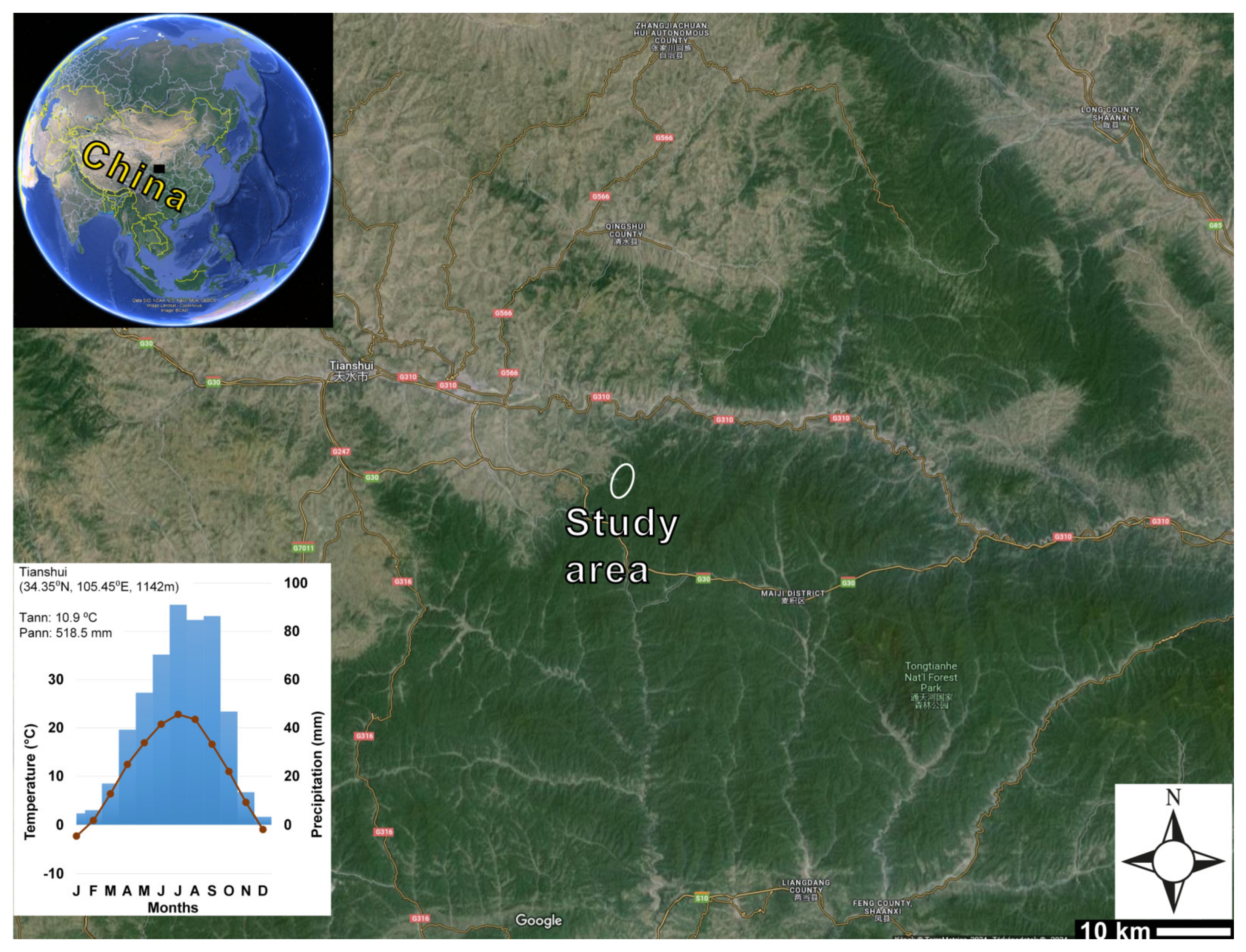
2.1. Site

The Xiaolong Mts are located in the West Qinling Mountain Range near Tianshui city and located in Tianshui area (34°26′27″ N, 106°07′29″ E, and 2085 m above sea level) in eastern Gansu Province (Figure 1). Gansu Province is locating in the southwestern sector of the erosion hotspot of China’s Loess Plateau [4].
Abundant forest coverage is maintained by orographic precipitation. Natural mixed pine–oak forests dominated by Chinese pine (Pinus tabulaeformis) and Liaotung oak (Quercus wutaishanica Mayr) occur also relatively frequently at certain places in this region [38]. The mountain has steep ridges, where many roots are conveniently exposed. The bedrock is coarse granite bearing thin soil cover classified as Leptic Cambisol, characterized by an organic matter content of 15 g kg−1 and a high content of sand and silt. The coarse soil structure is prone to water erosion. Gullies or small debris cones were not observed on the studied slopes so sheet erosion can be assumed to be the dominant type of soil erosion.
The region is at the marginal area of the Asian summer monsoon. Mean annual temperature is 10.9 °C and annual precipitation total is 520 mm at the nearby meteorological station (Tianshui). Annual rainfall is clearly concentrated in a wet season centered on July to September, registering ~51% of the annual precipitation total during these three months (Figure 1). The long-term average rainfall erosivity factor, the so-called R-factor, is moderate (~900 to 1000 MJ mm ha−1 h−1 a−1) in this region [39]. The soil erosion rate at the study site is around 10 t ha−1 a−1, but there are also areas with higher annual rates in the surroundings [3].

2.2. Sampling and Measurements

Procedures involved in the root-based reconstruction of soil erosion processes followed standard working steps [33]. Thirty root disk samples were taken (coded from SMM101 to SMM130) using a hand-saw in May 2010 (Table 1 and Table S1). The exhumed roots were collected during a survey of several hectares of slopes (Figure 2). In the vicinity of the exhumed roots, trees were spaced 1 to 4 m apart. Roots extend up to several meters from the trees, so unfortunately, for roots exhumed further away from the trunk, it was not possible to clearly identify which root belonged to which tree (Figure 2A). Therefore, we cannot say that each sample belongs to a different tree, but it is very likely. A single disc sample was taken from a root.
Needed parameters to quantify the erosion rate are the thickness of the eroded soil layer since exposure and the number of rings grown since exposure. Data for the first are measured both in the field (see Section 2.2.1) and in the laboratory (Figure 3); for the second, they are measured exclusively in the lab (see Section 2.2.2).

2.2.1. Field Methods

The following data were recorded for each sample: angle and aspect of slope and whether the root is parallel, perpendicular, or oblique to the slope. A detailed methodological description is provided in a separate paper [40]; only the key steps are listed below.
  • Roots overgrowing stones in the soil were not sampled: these cannot grow downwards, i.e., their pith possibly moves upwards due to growth in diameter [41].
  • Roots at least a meter away from stems were selected to avoid reaction wood potentially grown by the stress of the moving stem or erosion being overestimated due to the pull of the stem [42,43,44].
  • Ground surface was carefully cleared of leaf litter, taking care not to remove any soil.
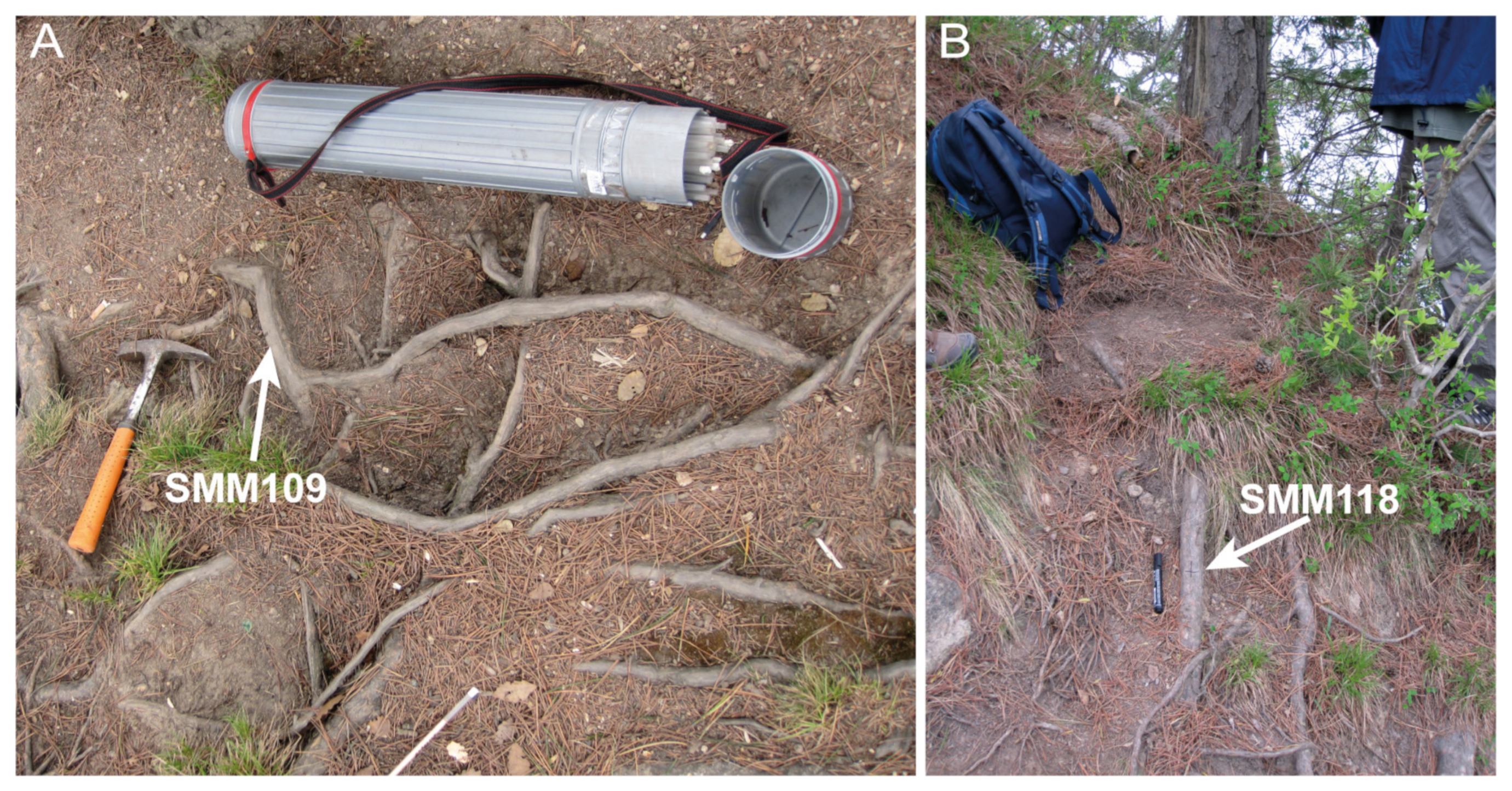
  • A cross was marked on the topmost portion of the root with indelible ink.
  • A photo was taken for documentation (Figure 2).
  • Azimuth and tilt of the slope were measured by a geological compass or by a simple compass and tiltmeter and rounded to the nearest 5°.
  • Direction of the root was recorded relative to the dip of the slope (parallel, perpendicular, or oblique). We note that we found that exposed roots in all directions were useful in the soil erosion reconstruction despite the recommendation of [33], in the caption to his Figure 10).
  • Height of the cross-marked top portion of the root above the homogeneous slope was measured on both sides [33] to the closest millimeter with the help of ruler and level or with a caliper; this measurement was always made in vertical direction (i.e., not perpendicularly to the slope, see Figure 3) and the average of the two values was used in calculations (see Section 2.3).
  • Soil was removed from both sides and from below the root for easy access for sawing.
  • A disk of ~20 to 50 mm thickness was sawed from the root (thickness was determined so as to allow the sample to be held easily by fingers during grinding and polishing, see Section 2.2.2).

2.2.2. Laboratory Methods

Specimens of sawn disks were left to dry as necessary (often for weeks) before grinding and polishing by a belt sander using the facilities of the Budapest Tree-Ring Laboratory [45]. Particular care was taken to preserve the cross marking on the top of the sample.
  • Direction of the top marker (drawn in the field) was marked again on at least one face of the disk.
  • Both faces were grinded on a belt sander using progressively finer grit sizes [46] beginning with P120 (~125 μm) and ultimately finishing with P400 (33.5–36.5 μm), which is usually enough for an almost polishing-level quality of the sanded face. Occasionally, in the case of very fine rings, we hand-sanded portions of the disk with a P800 (20.8–22.8 μm) sandpaper.
  • Exhumation markers, both geometrical and textural [40], were identified (see Section 2.2.3) under the microscope and marked with pencil.
  • The number of rings was counted from the outermost ring grown during the year of sampling towards the pith and calendar years were assigned. The outermost ring in this case was incomplete since sampling was carried out in the growing season. The rings were checked over the entire transect to also account for the frequently observed wedging rings.
  • Calendar years were assigned to exhumation markers.
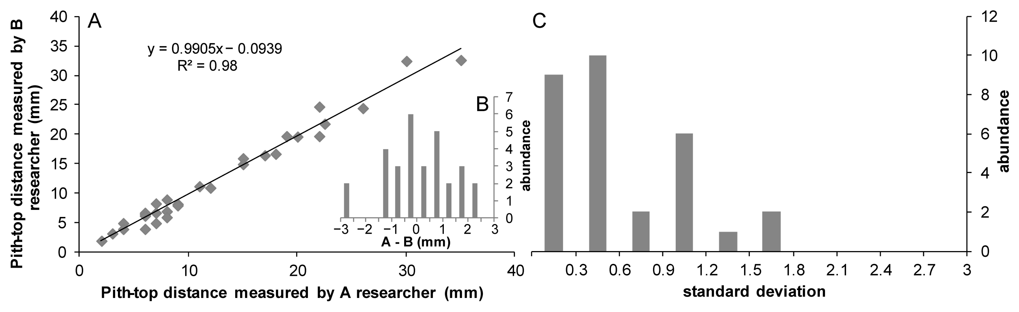
  • Distance between pith and the top of the sample was measured to the nearest 0.5 mm using a ruler or a caliper (Figure 3). Independent measurements of this parameter were performed to characterize the uncertainty of the laboratory measurements (see Appendix A).
  • Distance between the first exhumation marker and the top of the sample was similarly measured to the nearest 0.5 mm using a ruler or a caliper (Figure 3).

2.2.3. Exhumation Markers in Conifers

Roots, when exhumed above ground, display various features in their altered tissue. A detailed treatment is provided and anatomical exposure markers are discussed in a separate paper [40]. Here, we briefly discuss only the markers used in the present study, recognizable without specialist equipment. Recognition of these features allows us to date the exhumation and decide whether it was slow or fast [40]. Features are grouped as (1) change from root texture to stem texture (gradual or sudden), (2) formation of reaction wood of increased ring width and lignin content, (3) injuries causing wounds and their overgrowth ring patterns, and (4) phenolic staining.
  • Change from root texture to stem texture (Figure 4A). Soil-covered roots are largely protected from frost and drought. The reduced environmental signals mostly yield uniformly sized cell lumina and thin walls in the earlywood of conifer roots. Latewood is often a single row of cells only. Exposure to aboveground conditions usually yields smaller cell lumina and thicker cell walls, both in the earlywood and in the latewood. In macroscopic view, this change is displayed as lighter belowground and darker aboveground rings. Latewood is particularly affected by aboveground conditions: it is significantly thicker than the underground latewood. In short: roots produce xylem similar to that of stems after exposure to aboveground conditions [47].
  • Reaction wood is formed in the wood under mechanical stress. Conifers’ reaction wood has wider rings than normal. The first ring with reaction wood dates the exhumation of the root. Multiple tilting events in the same stem may be recognized by changes in—among others—orientation of compression wood [33].
  • Distorted symmetry (Figure 4B). The growth of rings with eccentric symmetry and of reaction wood goes hand-in-hand [31]. Root exhumation, mass movement, or tilting of the plant can disturb this symmetry.
  • Wounds (Figure 4C) are caused by injury to the root by mechanical means, mostly above ground, rarely below ground. If the cambium is damaged and suffers dieback, growth is stopped at that place, bark falls off, and an open wound is formed.
  • Phenolic staining (by dark, reddish-brown compounds) adjacent to the wound (Figure 4C). These precipitates isolate the open wound from infection by bacteria and fungi. External surface of the stain is parallel with a ring—this is the year when the injury occurred.

2.3. Calculations and Evaluation

Unclearly discernible ring boundaries accompanied with dense/narrow tree-ring structure were observed in three semi-ring porous samples, presumably derived from Quercus wutaishanica roots, which could not be used for further evaluation. However, all the conifer samples (n = 27) were suitable for erosion dating.
Values of field-measured exhumation on both sides of the root (A and B) are averaged (C) since most roots enclosed an angle with the dip of the slope and were exhumed asymmetrically (Figure 3). Since roots overgrowing stones were not sampled, we assumed stability of the root axis through time. In this case, only the subsequent growth of the upper part of the root (D) since exposure must be subtracted from the field-measured exhumation of the root section [41]. It was demonstrated that anatomical changes associated with root exposure can occur already when the soil cover is reduced below a critical thickness [36,41], resulting in a bias. A species-specific estimate of this bias was not determined for the study area, but the mean value (ε ≅ 50 mm) reported for roots of Pinus genera in previous studies [36,41] was taken. Exhumation rate—interpreted as mean annual erosion rate (Era)—was calculated since first exhumation as follows:
Era = (C − D + ε)/NRex
where NRex stands for the number of growth rings counted following the oldest exhumation mark, with consideration of incomplete rings grown only in a portion of circumference. It practically equals the years elapsed since the exposure of the root. The measurement unit of C, D, and ε parameters is mm.
Measurement uncertainty of the field measurements (A and B) can be assigned to ±2 mm, which corresponds to the reading uncertainty of the millimeter-scaled ruler based on our own long field experience. Measurement uncertainty of the lab measurements (D) was assigned to ±1.2 mm if D > 0, since standard deviation of the lab measurement was overwhelmingly found below this value (Appendix A) while measurement uncertainity was assigned to 0 when D = 0. Individual uncertainties of the components were combined following the Gaussian error propagation approach [48].
Monthly precipitation totals and the monthly maximum daily precipitation sum (Rx1day) corresponding to the study site were retrieved from CRU TS4.07 [49] and HadEX2 [50] datasets, respectively, and combined to estimate monthly rainfall erosivity factor (R) following the Monthly III model of [51] as follows:
Rmonth = 0.077 × Pmonth × Rx1daymonth
Monthly estimates of the rainfall erosivity factor were aggregated for each year to approximate the yearly erosivity factor (R), since better prediction capabilities resulted from using the finer resolution rainfall data as inputs at a given erosivity timescale and by summing results for coarser erosivity timescales [51].
Most soil erosion is induced by a small number of intense rainstorms with short duration and high rainfall intensity [12]. To account for the rainfall events or series of events within a year, annual Rx1day and maximum consecutive 5-day precipitation amount (Rx5day) were considered as indicators of short-period erosional activity for each year, retrieved again from HadEX2 [50]. The time series were screened to find the highest index values below which a root exhumation event did not occur and the lowest index in which exceedance was always accompanied by a root exhumation event. These index values could serve as empirical thresholds to define calm and intense conditions for soil erosional activity.

3. Results and Discussion

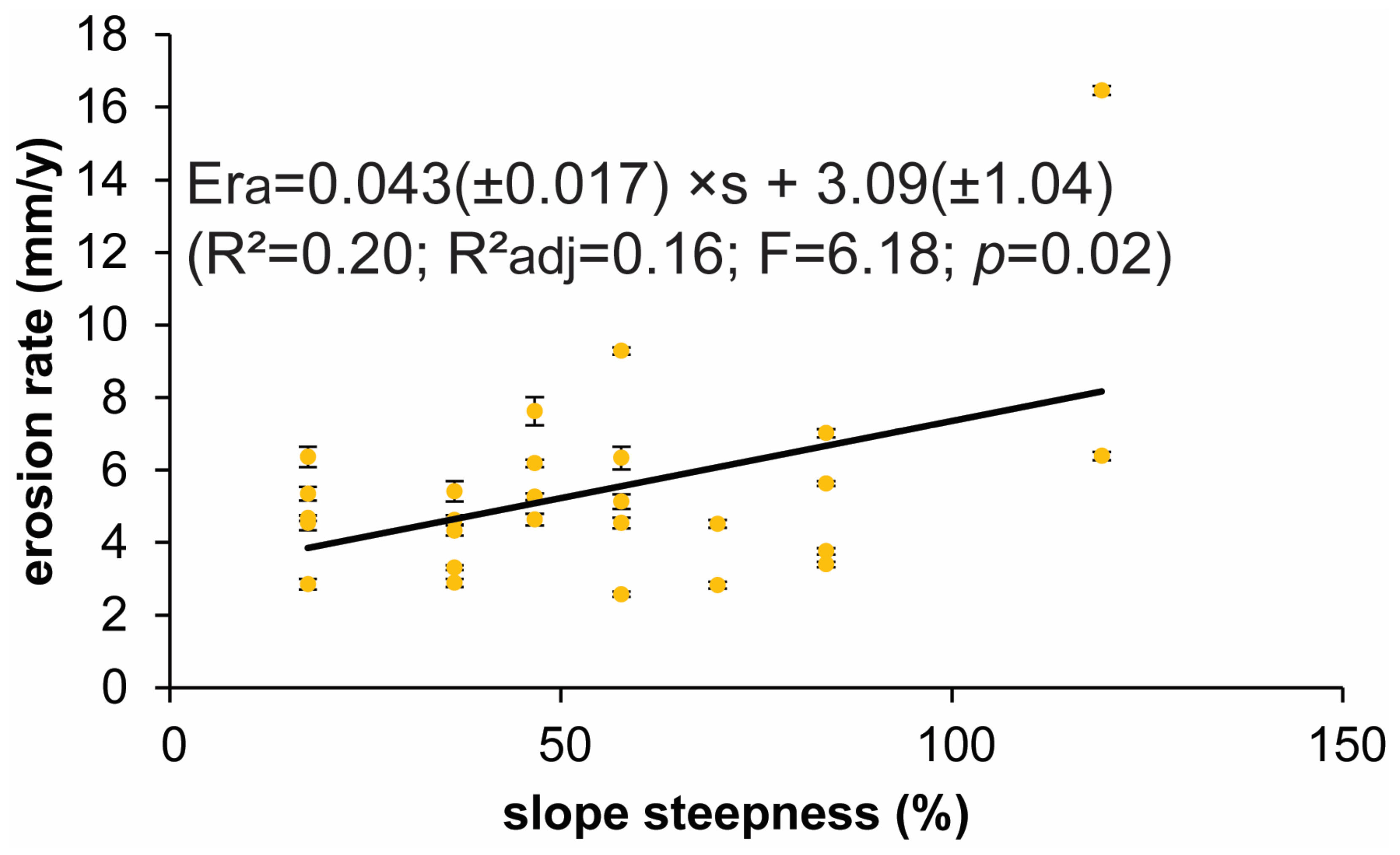
3.1. Rate and Time of Erosion

The first appearance of exhumation texture in the studied root sections appeared in 19 years between 1967 and 2002 (Table S1). More than one root exhumation appearance was dated to five years, and the most represented year is 1983 with four initiations; however, there is no obvious temporal clustering in the occurrence of the root exhumation events. We tend to interpret this as suggesting that the detected erosion events cannot be dominated anthropogenic causes, but this allows us to infer the evolution of erosion processes caused by natural factors over time.
The calculated erosion rate estimates ranged from 2.6 to 16.5 mm yr−1 (Table 1). These values fit well to the published dendrogeomorphic reconstructions of erosion rates [33]. The limited data at hand is obviously insufficient to evaluate any potential difference related to slope facing. However, the expected positive association between slope steepness and erosion rate [20,52,53] is well reflected in the dataset (Figure 5). It is in agreement with the findings of other dendrogeomorphic studies detecting a positive relation between slope angle and erosion rates robustly at different timescales [36,41]. These observations further strengthen the credibility of root exhumation-based erosion rate estimates, which is worth emphasis since a recent analysis of erosion and runoff measurements on erosion plots in non-crop land use types in China did not find a systematic association with slope gradient either with the soil losses or with the runoff rates [6]. The presented regression model between slope steepness as an independent variable and erosion rate as a dependent variable (Figure 5) could be used in future research to determine and to map soil denudation in this part of the Xiaolong Mts without the need for expensive instrumentation.

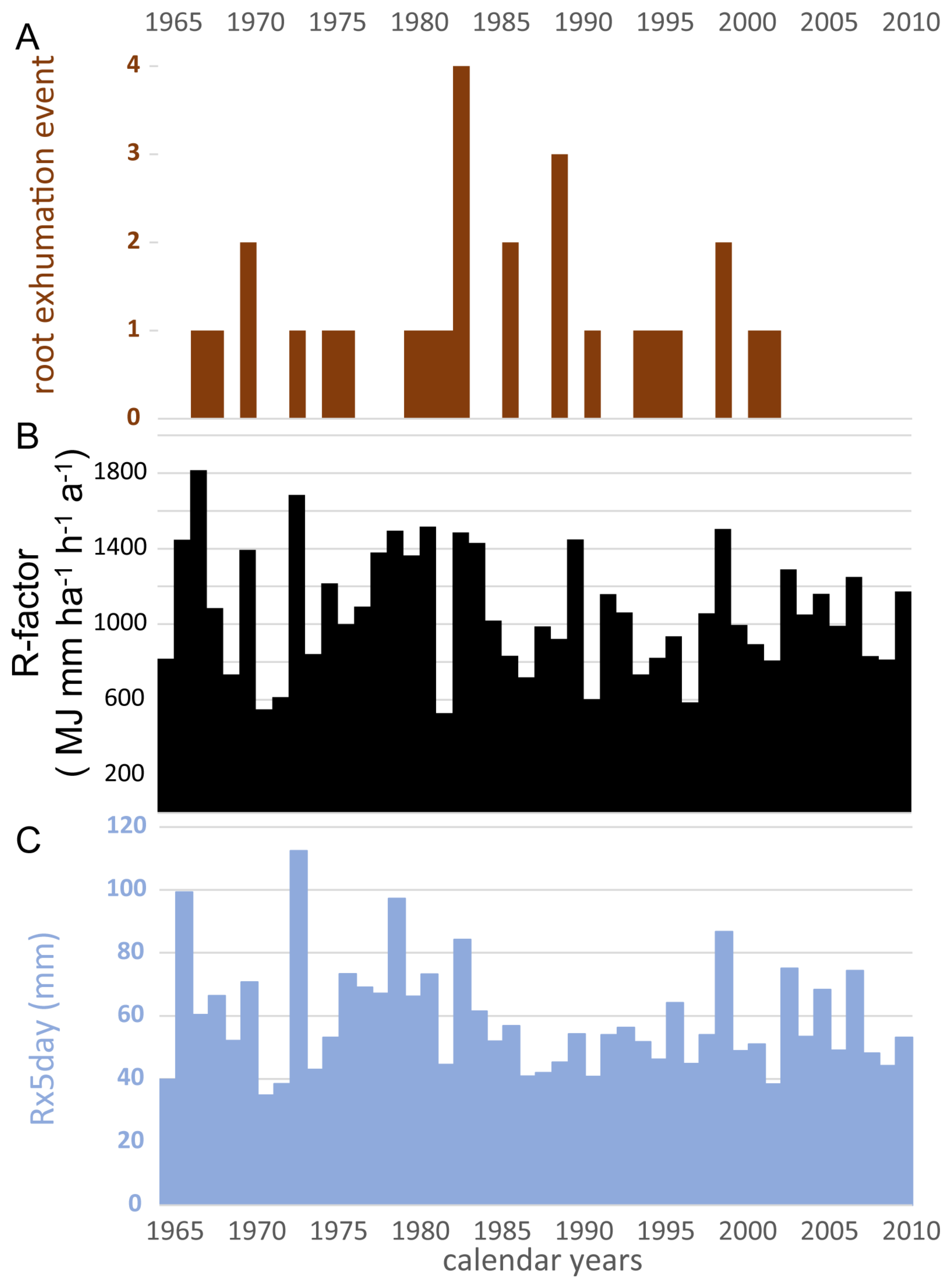
3.2. Coincidence between Wet Summers and Root-Based Erosion Events in the Xiaolong Mts between 1967 and 2002

Dendrogeomorphic evidence of root exhumation was lacking in each year when the sum of the estimated yearly erosivity factor did not reach 822 MJ mm ha−1 h−1 a−1, while R > 1448 MJ mm ha−1 h−1 a−1 was always accompanied by root exposure evidence either in the same year or in the consecutive season (Figure 6). Considering the current estimate of the average R-factor (~1000 MJ mm ha−1 h−1 a−1) in this region [39], this suggests that a yearly R-factor exceeding by ~45% the long-term average always induces major erosion in the pine forest of the Xiaolong Mts. The projected average R-factor increase ranges from 26 up to 46.5% for the long-term (2076–2100) in mainland China depending on the considered climate change scenario [13]. Taking this range of increase, the average erosivity factor might become the norm for inducing root exhumation in the Xiaolong Mts by the end of the 21st century. The match between the longest period continuously recording root exhumation (1980–1983) and the time interval (1978–1983) experiencing an estimated yearly R-factor > 1365 MJ mm ha−1 h−1 a−1 in all but one year (Figure 6) strengthens the view that an increase >40% in the R-factor is surely a critical forecast for the soil erosion in this region.
Since the projected R-factor increase is primarily attributed to the elevated probability of extreme precipitation events [13], the temporal correspondence between extreme rainfall events and soil erosion events deserves scrutiny considering their strong coupling [12]. A simple visual inspection revealed notable associations between erosive rainfalls and root exhumation events. A root exhumation event was not documented in the Xiaolong Mts between 1965 and 2010 if the maximum daily precipitation sum (Rx1day) was below 30 mm. If an Rx1day exceeding 56 mm appeared in a year, then it was always accompanied by root exposure evidence either in the same year or in the consecutive season. This empirical threshold is close to, although slightly above, the erosive rainstorm criterion for daily rainfall durations in the Loess Plateau [54]. Similar correspondence was observed with the maximum consecutive 5-day precipitation amount (Rx5day), as well. A root exhumation event did not occur in the Xiaolong Mts between 1965 and 2010 if the Rx5day was below 45 mm in two consecutive years. However, if the Rx5day exceeded 73 mm in a year then it was always accompanied by root exposure evidence either in the same year or in the consecutive season (Figure 6). These empirically identified thresholds of extreme rainfall events can contribute practical clues considering the impact of extreme rainfall erosivity on soil erosion, and improving rainfall erosivity estimation [12] in the forest environments of the Xiaolong Mts, or maybe even for the wider Gansu region.
The lack of identified exposure events after 2002 (Figure 6), or even any exposure scar after 2005 (Table S1), is tempting to link to the documented decrease in soil erosion in the Loess Plateau region between 2000 and 2008 [4], leading to praise for the efficacy of the great efforts targeting soil and water conservation, such as Grain for Green across China’s Loess Plateau. However, we are afraid that this pattern instead points to a methodological limitation which needs improvement in future applications. Smaller root(let)s potentially experience and are capable of documenting the most recent exposure events, and could be too small to attract attention in the field. In this dataset, for instance, the smallest sampled roots were ~1 cm wide. A general methodological suggestion can be to also pay special attention to the strings of small exposed root(let)s.

3.3. Microscopic versus Macroscopic Analysis

Recently, there has been a shift in studies of root-based erosion measurements from ring width variations and textural changes towards microscopic analysis and dating of exposure [24,33,55]. While the latter method is certainly more sensitive to oncoming exhumation and can sense the approach of soil surface even a few years before it reaches the root [41], it needs special wood anatomical equipment and is time-consuming. Despite all above-mentioned limitations, the presented results argue that the ‘old-fashioned’ identification of tree ring pattern features is capable of promoting further studies in this field by those who have no access to a specialized laboratory.

4. Conclusions

Based upon the anatomical changes of exposed tree roots of Chinese pine (Pinus tabulaeformis) from the Xiaolong Mts near Tianshui city, Gansu, China, we reconstructed a soil erosion history dating back to the late 1960s and quantitative estimates of soil erosion rate were developed for the first time. A linear regression model between slope steepness as an independent variable and erosion rate was established and could be used in future research to determine soil denudation in this part of the Xiaolong Mts.
The correspondence between an erosivity factor exceeding 1448 MJ mm ha−1 h−1 a−1 in the year or in the preceding year of a root exhumation event indicates a threshold of soil erosion in the studied pine forest environment. Furthermore, daily and 5-day precipitation totals of 56 and 73 mm, respectively, seem to be critical thresholds which if exceeded it will always induce root exhumation in the same year or in the consecutive season. The projected increase of the R-factor is primarily attributed to the elevated probability of extreme precipitation events [13], and together with the documented strong coupling between heavy rainfall extremes and soil erosion [12] highlights the need for enhanced soil and water conservation measures in Gansu Province to mitigate the challenges posed by ongoing climate change. The lack of reconstructed data after 2002 in this dataset might be due to a sampling bias as the strings of the smallest exposed root(let)s can be unrecognized and unintentionally avoided in the field.

Supplementary Materials

The following supporting information can be downloaded at: https://www.mdpi.com/article/10.3390/land13060771/s1, Table S1: Complementary data for the exhumed root samples collected in Xiaolong Mts near Tianshui city (Gansu, China) in May 2010 for dendrogeomorphological analysis.

Author Contributions

Conceptualization, M.K., K.F., Y.Z. and Z.K.; methodology, M.K. and Z.K.; formal analysis, Z.K.; investigation, M.K., K.F., Y.Z. and Z.K.; writing—original draft preparation, M.K. and Z.K.; writing—review and editing, M.K., K.F., Y.Z. and Z.K.; visualization, M.K. and Z.K.; supervision, M.K., K.F. and Y.Z.; funding acquisition, M.K., K.F. and Y.Z. All authors have read and agreed to the published version of the manuscript.

Funding

This research was funded by Chinese–Hungarian scientist exchange program, grant number CN-48/2007.

Data Availability Statement

Data are contained within the article or Supplementary Materials.

Acknowledgments

This is contribution No. 90 of ‘2ka Palæoclimatology’ Research Group and No. 41 of Budapest Tree-Ring Laboratory.

Conflicts of Interest

The authors declare no conflicts of interest.

Appendix A

In order to characterize the uncertainty of the laboratory measurements, pith-to-top distances were measured by two analysts (A, B) independently on each of the 30 sampled root discs. B researcher performed two measurements, and in some cases repeated the measurement another time. So finally, at least three measurements were available on the same parameter and the subjectivity bias could be also evaluated comparing the data obtained from A and B researchers’ measurements.
Measurement results of the two independent analysts show excellent agreement (Figure A1A); the difference between the measured data is ≤1 mm in 70% of the cases (Figure A1B). The negative intercept of the regression slope (Figure A1A), and the slightly skewed histogram of the inset chart showing the distribution of the difference between measured values of A researcher and the mean of the measurements of B researcher (Figure A1B) suggest that A researcher tended to measure slightly larger distances.
The histogram showing the distribution of the standard deviation of the pith-to-top distance recorded for all root discs shows that overwhelmingly (>90%) it was below 1.2 mm. To provide a quantitative estimate on the uncertainty of the laboratory distance measurements, we adopted this value which includes both the uncertainty of the repeated measurements and the subjectivity error of independent analysts.
Figure A1. Assessing uncertainty of the laboratory distance measurements of the study. (A) Crossplot between pit-to-top distance measured on the 30 studied root discs by A and B researcher; (B) histogram of the difference between the measurements of A and B researcher; (C) distribution of the standard deviation of the pith-to-top distance records for all root discs calculated from the merged dataset.
Land 13 00771 g0a1

References

  1. Verheijen, F.G.A.; Jones, R.J.A.; Rickson, R.J.; Smith, C.J. Tolerable versus actual soil erosion rates in Europe. Earth-Sci. Rev. 2009, 94, 23–38. [Google Scholar] [CrossRef]
  2. Keesstra, S.; Mol, G.; De Leeuw, J.; Okx, J.; Molenaar, C.; De Cleen, M.; Visser, S. Soil-Related Sustainable Development Goals: Four Concepts to Make Land Degradation Neutrality and Restoration Work. Land 2018, 7, 133. [Google Scholar] [CrossRef]
  3. Liu, B.; Xie, Y.; Li, Z.; Liang, Y.; Zhang, W.; Fu, S.; Yin, S.; Wei, X.; Zhang, K.; Wang, Z.; et al. The assessment of soil loss by water erosion in China. Int. Soil Water Conserv. Res. 2020, 8, 430–439. [Google Scholar] [CrossRef]
  4. Fu, B.; Wang, S.; Liu, Y.; Liu, J.; Liang, W.; Miao, C. Hydrogeomorphic Ecosystem Responses to Natural and Anthropogenic Changes in the Loess Plateau of China. Annu. Rev. Earth Planet. Sci. 2017, 45, 223–243. [Google Scholar] [CrossRef]
  5. Sun, J.; Zhang, N.; Shi, M.; Zhai, Y.; Wu, F. The effects of tillage induced surface roughness, slope and discharge rate on soil detachment by concentrated flow: An experimental study. Hydrol. Process. 2021, 35, e14261. [Google Scholar] [CrossRef]
  6. Zhao, J.; Wang, Z.; Dong, Y.; Yang, Z.; Govers, G. How soil erosion and runoff are related to land use, topography and annual precipitation: Insights from a meta-analysis of erosion plots in China. Sci. Total Environ. 2022, 802, 149665. [Google Scholar] [CrossRef] [PubMed]
  7. Nearing, M.A.; Bradford, J.M. Single Waterdrop Splash Detachment and Mechanical Properties of Soils. Soil Sci. Soc. Am. J. 1985, 49, 547–552. [Google Scholar] [CrossRef]
  8. Van Dijk, A.I.J.M.; Bruijnzeel, L.A.; Eisma, E.H. A methodology to study rain splash and wash processes under natural rainfall. Hydrol. Process. 2003, 17, 153–167. [Google Scholar] [CrossRef]
  9. Nanko, K.; Mizugaki, S.; Onda, Y. Estimation of soil splash detachment rates on the forest floor of an unmanaged Japanese cypress plantation based on field measurements of throughfall drop sizes and velocities. CATENA 2008, 72, 348–361. [Google Scholar] [CrossRef]
  10. Szabó, J.A.; Centeri, C.; Keller, B.; Hatvani, I.G.; Szalai, Z.; Dobos, E.; Jakab, G. The Use of Various Rainfall Simulators in the Determination of the Driving Forces of Changes in Sediment Concentration and Clay Enrichment. Water 2020, 12, 2856. [Google Scholar] [CrossRef]
  11. Szabó, J.A.; Keller, B.; Centeri, C.; Hatvani, I.G.; Kovács, J.; Szalai, Z.; Jakab, G. Varying particle size selectivity of soil erosion along a cultivated catena. Open Geosci. 2023, 15, 20220585. [Google Scholar] [CrossRef]
  12. Zhao, Y.; Zhu, D.; Wu, Z.; Cao, Z. Extreme rainfall erosivity: Research advances and future perspectives. Sci. Total Environ. 2024, 917, 170425. [Google Scholar] [CrossRef]
  13. Wang, W.; Yin, S.; He, Z.; Chen, D.; Wang, H.; Klik, A. Projections of rainfall erosivity in climate change scenarios for mainland China. CATENA 2023, 232, 107391. [Google Scholar] [CrossRef]
  14. Godfrey, A.E.; Everitt, B.L.; Duque, J.F.M. Episodic sediment delivery and landscape connectivity in the Mancos Shale badlands and Fremont River system, Utah, USA. Geomorphology 2008, 102, 242–251. [Google Scholar] [CrossRef]
  15. Lucía, A.; Laronne, J.B.; Martín-Duque, J.F. Geodynamic processes on sandy slope gullies in central Spain field observations, methods and measurements in a singular system. Geodin. Acta 2011, 24, 61–79. [Google Scholar] [CrossRef]
  16. Mabit, L.; Benmansour, M.; Walling, D.E. Comparative advantages and limitations of the fallout radionuclides 137Cs, 210Pbex and 7Be for assessing soil erosion and sedimentation. J. Environ. Radioact. 2008, 99, 1799–1807. [Google Scholar] [CrossRef] [PubMed]
  17. Kalkan, K.S.; Forkapić, S.; Marković, S.B.; Bikit, K.; Gavrilov, M.B.; Tošić, R.; Mrđa, D.; Lakatoš, R. The application of 137Cs and 210Pbex methods in soil erosion research of Titel loess plateau, Vojvodina, Northern Serbia. Open Geosci. 2020, 12, 11–24. [Google Scholar] [CrossRef]
  18. Šamonil, P.; Jaroš, J.; Daněk, P.; Tikhomirov, D.; Novotný, V.; Weiblen, G.; Christl, M.; Egli, M. Soil erosion affected by trees in a tropical primary rain forest, Papua New Guinea. Geomorphology 2023, 425, 108589. [Google Scholar] [CrossRef]
  19. Markose, V.J.; Jayappa, K.S. Soil loss estimation and prioritization of sub-watersheds of Kali River basin, Karnataka, India, using RUSLE and GIS. Environ. Monit. Assess. 2016, 188, 225. [Google Scholar] [CrossRef] [PubMed]
  20. Koirala, P.; Thakuri, S.; Joshi, S.; Chauhan, R. Estimation of Soil Erosion in Nepal Using a RUSLE Modeling and Geospatial Tool. Geosciences 2019, 9, 147. [Google Scholar] [CrossRef]
  21. Chen, P.; Czymzik, M.; Yu, Z.; Aldahan, A.; Wang, J.; Yi, P.; Hou, X.; Guo, S.; Zheng, M. Tendency of soil erosion dynamics by coupling radioisotopes and RUSLE model on the Southeastern Tibetan Plateau in response to climate warming and human activity. CATENA 2023, 223, 106954. [Google Scholar] [CrossRef]
  22. Zheng, F.-L. Effect of Vegetation Changes on Soil Erosion on the Loess Plateau1 1Project supported by the Chinese Academy of Sciences (No. KZCX3-SW-422) and the National Natural Science Foundation of China (Nos. 9032001 and 40335050). Pedosphere 2006, 16, 420–427. [Google Scholar] [CrossRef]
  23. Zhou, F.; Gou, X.; Zhang, J.; Zhao, Z.; Chen, Q.; Cao, Z. Application of Picea wilsonii roots to determine erosion rates in eastern Qilian Mountains, Northwest China. Trees 2013, 27, 371–378. [Google Scholar] [CrossRef]
  24. Bodoque, J.M.; Lucía, A.; Ballesteros, J.A.; Martín-Duque, J.F.; Rubiales, J.M.; Genova, M. Measuring medium-term sheet erosion in gullies from trees: A case study using dendrogeomorphological analysis of exposed pine roots in central Iberia. Geomorphology 2011, 134, 417–425. [Google Scholar] [CrossRef]
  25. Hao, H.; Cheng, L.; Guo, Z.; Wang, L.; Shi, Z. Plant community characteristics and functional traits as drivers of soil erodibility mitigation along a land degradation gradient. Land Degrad. Dev. 2020, 31, 1851–1863. [Google Scholar] [CrossRef]
  26. Kou, M.; Jiao, J.; Yin, Q.; Wang, N.; Wang, Z.; Li, Y.; Yu, W.; Wei, Y.; Yan, F.; Cao, B. Successional Trajectory Over 10 Years of Vegetation Restoration of Abandoned Slope Croplands in the Hill-Gully Region of the Loess Plateau. Land Degrad. Dev. 2016, 27, 919–932. [Google Scholar] [CrossRef]
  27. Schulman, E. Root Growth-Rings and Chronology. Tree-Ring Bull. 1945, 12, 2–5. [Google Scholar]
  28. Krause, C.; Eckstein, D. Dendrochronology of roots. Dendrochronologia 1993, 11, 9–23. [Google Scholar]
  29. Hueck, K. Eine biologische Methode zum Messen der erodierten Tätigkeit des Windes und des Wassers. Berichte Dtsch. Bot. Ges. 1951, 64, 53–56. [Google Scholar]
  30. LaMarche, V. Rate of slope erosion in the white mountains, California. GSA Bull. 1961, 72, 1579. [Google Scholar] [CrossRef]
  31. Carrara, P.E.; Carroll, T.R. The determination of erosion rates from exposed tree roots in the Piceance Basin, Colorado. Earth Surf. Process. 1979, 4, 307–317. [Google Scholar] [CrossRef]
  32. McCord, V.A.S. Late Holocene sediment yield and transport in a northern Arizona drainage basin reconstructed by tree-ring analysis. In Proceedings of the International Symposium on Ecological Aspects of Tree-ring Analysis, Tarrytown, NY, USA, 17–21 August 1986; pp. 213–223. [Google Scholar]
  33. Stoffel, M.; Corona, C.; Ballesteros-Cánovas, J.A.; Bodoque, J.M. Dating and quantification of erosion processes based on exposed roots. Earth-Sci. Rev. 2014, 123, 18–34. [Google Scholar] [CrossRef]
  34. Gärtner, H. Tree roots—Methodological review and new development in dating and quantifying erosive processes. Geomorphology 2007, 86, 243–251. [Google Scholar] [CrossRef]
  35. Luo, M.; Zhou, Y.; Wang, K. Soil Erosion Characteristics According to Tree-rings in a Karst Area. J. Resour. Ecol. 2015, 6, 257–262. [Google Scholar] [CrossRef]
  36. Zhang, D.; Zhou, F.; Fang, K.; Davi, N.; Chen, Z.; Wang, F.; Chen, Y. Quantification of soil erosion dynamics in the hilly red soil region of Southeast China based on exposed roots. CATENA 2023, 232, 107386. [Google Scholar] [CrossRef]
  37. Zhang, Y.; Fang, K.; Zhou, F.; Dong, Z.; Li, Y.; Zhang, P. Reconstruction of soil erosion rates from exposed roots in southeast China. Asian Geogr. 2017, 34, 91–105. [Google Scholar] [CrossRef]
  38. Fang, K.; Gou, X.; Chen, F.; Frank, D.; Liu, C.; Li, J.; Kazmer, M. Precipitation variability during the past 400 years in the Xiaolong Mountain (central China) inferred from tree rings. Clim. Dyn. 2012, 39, 1697–1707. [Google Scholar] [CrossRef]
  39. Yue, T.; Yin, S.; Xie, Y.; Yu, B.; Liu, B. Rainfall erosivity mapping over mainland China based on high-density hourly rainfall records. Earth Syst. Sci. Data 2022, 14, 665–682. [Google Scholar] [CrossRef]
  40. Kázmér, M.; Kern, Z.; Fang, K.; Zhou, Y.-c. Tree ring pattern of roots exhumed by soil erosion. Hantkeniana 2014, 9, 133–167. [Google Scholar]
  41. Corona, C.; Lopez Saez, J.; Rovéra, G.; Stoffel, M.; Astrade, L.; Berger, F. High resolution, quantitative reconstruction of erosion rates based on anatomical changes in exposed roots at Draix, Alpes de Haute-Provence—Critical review of existing approaches and independent quality control of results. Geomorphology 2011, 125, 433–444. [Google Scholar] [CrossRef]
  42. Mattheck, C.; Breloer, H. The Body Language of Trees: A Handbook for Failure Analysis; HMSO Publications Centre: London, UK, 1994. [Google Scholar]
  43. Stokes, M.A.; Smiley, T.L. An Introduction to Tree-Ring Dating; University of Chicago Press: Chicago, IL, USA, 1968. [Google Scholar]
  44. Watson, A. Wind-induced forces in the near-surface lateral roots of radiata pine. For. Ecol. Manag. 2000, 135, 133–142. [Google Scholar] [CrossRef]
  45. Kern, Z.; Árvai, M.; Kázmér, M. The Budapest Tree-Ring Laboratory—Status report after 20 years of activity. Cent. Eur. Geol. 2023; 66, in press. [Google Scholar]
  46. Orvis, K.H.; Grissino-Mayer, H.D. Standardizing the reporting of abrasive papers used to surface tree-ring samples. Tree-Ring Res. 2002, 58, 47–50. [Google Scholar]
  47. Patel, R. A comparison of the anatomy of the secondary xylem in roots and stems. Holzforschung 1965, 19, 72–79. [Google Scholar] [CrossRef]
  48. Clifford, A.A. Multivariate Error Analysis; Applied Science Publishers: Essex, UK, 1973. [Google Scholar]
  49. Harris, I.; Osborn, T.J.; Jones, P.; Lister, D. Version 4 of the CRU TS monthly high-resolution gridded multivariate climate dataset. Sci. Data 2020, 7, 109. [Google Scholar] [CrossRef] [PubMed]
  50. Donat, M.G.; Alexander, L.V.; Yang, H.; Durre, I.; Vose, R.; Dunn, R.J.H.; Willett, K.M.; Aguilar, E.; Brunet, M.; Caesar, J.; et al. Updated analyses of temperature and precipitation extreme indices since the beginning of the twentieth century: The HadEX2 dataset. J. Geophys. Res. Atmos. 2013, 118, 2098–2118. [Google Scholar] [CrossRef]
  51. Yin, S.; Xie, Y.; Liu, B.; Nearing, M.A. Rainfall erosivity estimation based on rainfall data collected over a range of temporal resolutions. Hydrol. Earth Syst. Sci. 2015, 19, 4113–4126. [Google Scholar] [CrossRef]
  52. Zingg, A.W. Degree and length of land slope as it affects soil loss in run-off. Agric. Eng. 1940, 21, 59–64. [Google Scholar]
  53. Assouline, S.; Ben-Hur, M. Effects of rainfall intensity and slope gradient on the dynamics of interrill erosion during soil surface sealing. CATENA 2006, 66, 211–220. [Google Scholar] [CrossRef]
  54. Wang, W.Z.; Jiao, J.Y. Rainfall and Erosion Sediment Yield and Sediment Reduction of Soil and Water Conservation in the Loess Plateau; Science China Press: Beijing, China, 2018. (In Chinese) [Google Scholar]
  55. Gärtner, H.; Schweingruber, F.H.; Dikau, R. Determination of erosion rates by analyzing structural changes in the growth pattern of exposed roots. Dendrochronologia 2001, 19, 81–91. [Google Scholar]
Figure 1. Location of Xiaolong Mts near Tianshui city. The study area is indicated in the main map (white ellipse), while the enlarged region is indicated by the black square to show the wider geographical context in the inset globe. Map source: GoogleEarth 2024. Inset graph: climate diagram for the Tianshui meteorological station showing the monthly mean temperature (solid line) and monthly precipitation (bar).
Land 13 00771 g001
Figure 2. Field photos of exhumed roots. (A) A network of exhumed roots probably belonging to multiple trees. The position of sample SMM109 is shown. (B) Exhumed roots parallel to the slope. The position of sample SMM118 is shown.
Land 13 00771 g002
Figure 3. The scheme of measurements on exhumed roots. Soil-covered root: circular annual rings. Exhumed root: elliptical rings. To be measured in the field: A and B are the exhumation data of the top of the root above the soil surface on opposing sides of the root. C is the average of A and B. To be measured in the laboratory: D is the distance of the (first) exhumation marker from top of the root. ε is the thickness of the soil cover above the root at the appearance of the first exhumation marker. C − D + ε is the estimated total eroded thickness of soil since the first exhumation marker.
Land 13 00771 g003
Figure 4. Examples of exhumation markers in exposed conifer roots. (A) Stepwise change from root texture to stem texture. Light, concentric rings with narrow latewood were substituted by increasingly elliptical rings with wide latewood (thin arrow) in the year of rapid exhumation. Later, irregular rings of reaction wood (thick arrow) mark the effect of mechanical stress. Resin ducts visible throughout. (B) Distorted symmetry. Narrow rings with thin latewood belong to underground roots. Rapid exhumation yielded reaction wood of wide rings and thick latewood (arrow). (C) Wound. Gradual change from root texture (narrow rings with barely visible latewood) in the center to stem texture along the margins is observed. It is evidence for gradual exhumation. There is a wound on top (arrow) overgrown by subsequent rings and covered by bark. Brownish phenolic compounds indicate the presence of another wound, out of the plane of the section. Resin ducts visible throughout. Scale: 10 × 10 mm grid pattern in black background.
Land 13 00771 g004
Figure 5. Estimated soil erosion rate (Era) and slope steepness (s) in the Xiaolong Mts (Gansu Province, China) and the derived linear regression model.
Land 13 00771 g005
Figure 6. Root exhumation events documented in the Xiaolong Mts (Gansu Province, China) and annual rainfall erosivity indicators between 1965 and 2010. (A) Annual sum of detected root exhumation markers; (B) annual sum of monthly estimates of rainfall erosivity factor (Equation (2) and Section 2.3); (C) yearly maximum consecutive 5-day precipitation amount (Rx5day) retrieved from HadEX2 [50] corresponding to the study site.
Land 13 00771 g006
Table 1. Exhumed root samples with the inferred basic input parameters and estimated average soil erosion rate taken from Xiaolong Mts, Gansu, China. Variable codes in the topmost row refer to Equation (1). Estimated uncertainty of Era is presented in brackets.
Variable in Equation (1)-CDNRexEra
Sample CodeSlope SteepnessAverage Exposure 1Exposure to Root TopYears Elapsed Since First ExposureAverage Erosion Rate
%mmmmyrmm yr−1
SMM10136.4890423.3 (0.1)
SMM10217.613.50144.5 (0.2)
SMM10317.6122212.9 (0.1)
SMM10446.620987.6 (0.4)
SMM10546.6402194.6 (0.2)
SMM10657.7471.7214.5 (0.1)
SMM10757.728.51.5155.1 (0.2)
SMM10857.77096.3 (0.3)
SMM10917.6404.5165.3 (0.2)
SMM11036.4177.5115.4 (0.3)
SMM11117.61285374.7 (0.1)
SMM11217.6255116.4 (0.3)
SMM11336.4632244.6 (0.1)
SMM11436.4324272.9 (0.1)
SMM11570.0876294.5 (0.1)
SMM11636.45110214.3 (0.1)
SMM11746.61170276.2 (0.1)
SMM11870.0515342.8 (0.1)
SMM11957.76815402.6 (0.1)
SMM12357.72100289.3 (0.1)
SMM124119.234502416.5 (0.1)
SMM12583.9831.5353.8 (0.1)
SMM12683.91750405.6 (0.1)
SMM12783.911014433.4 (0.1)
SMM12883.91400.5277.0 (0.1)
SMM129119.21285.5276.4 (0.1)
SMM13046.61080305.3 (0.1)
1 Mean of field measurements at both sides of the exposed root section. For the original field measurements see Table S1.
Disclaimer/Publisher’s Note: The statements, opinions and data contained in all publications are solely those of the individual author(s) and contributor(s) and not of MDPI and/or the editor(s). MDPI and/or the editor(s) disclaim responsibility for any injury to people or property resulting from any ideas, methods, instructions or products referred to in the content.

