Landscape Ecological Risk and Drivers of Land-Use Transition under the Perspective of Differences in Topographic Gradient
Abstract
:1. Introduction
2. Materials and Methods
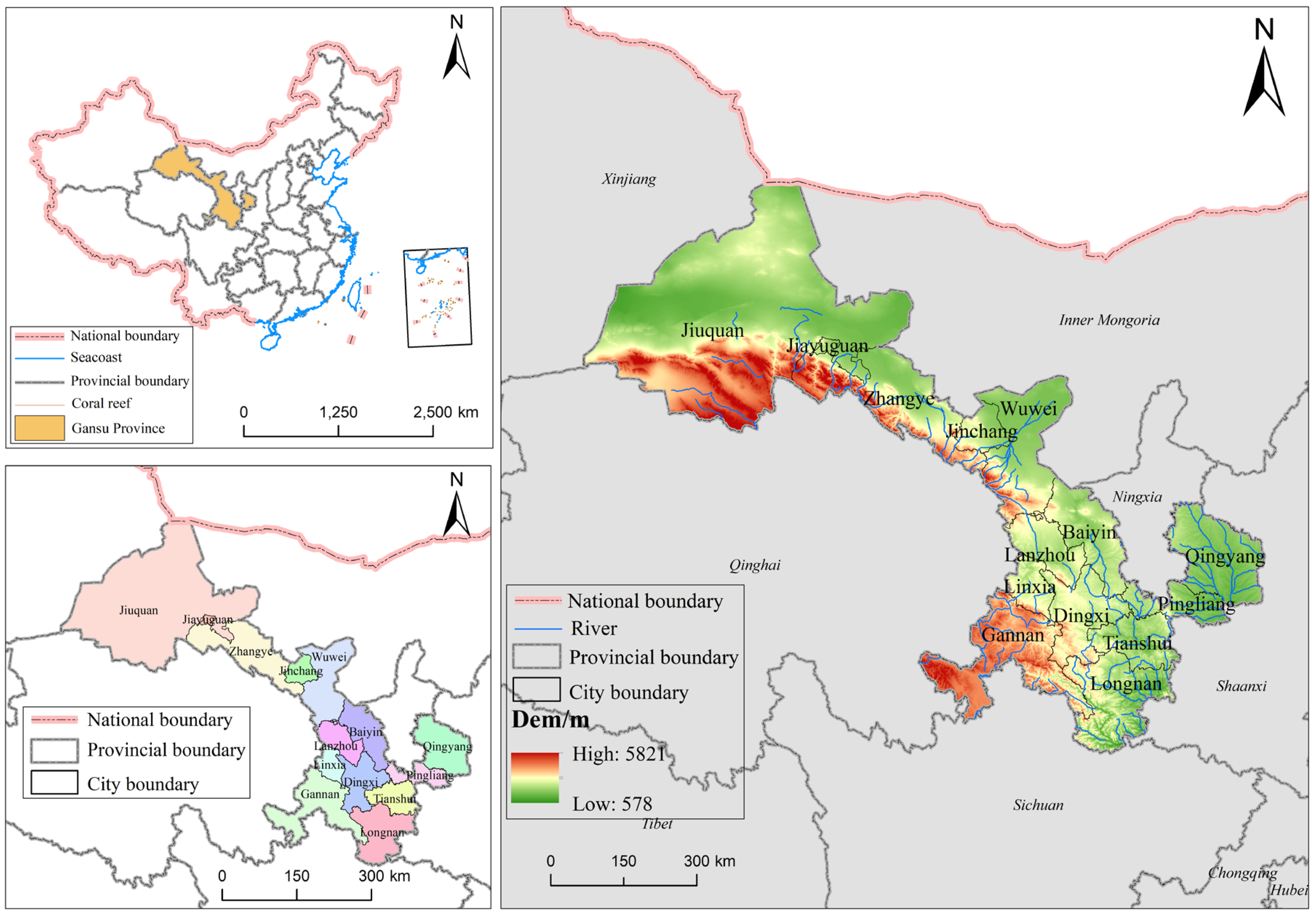
2.1. Study Area
2.2. Data Source and Processing
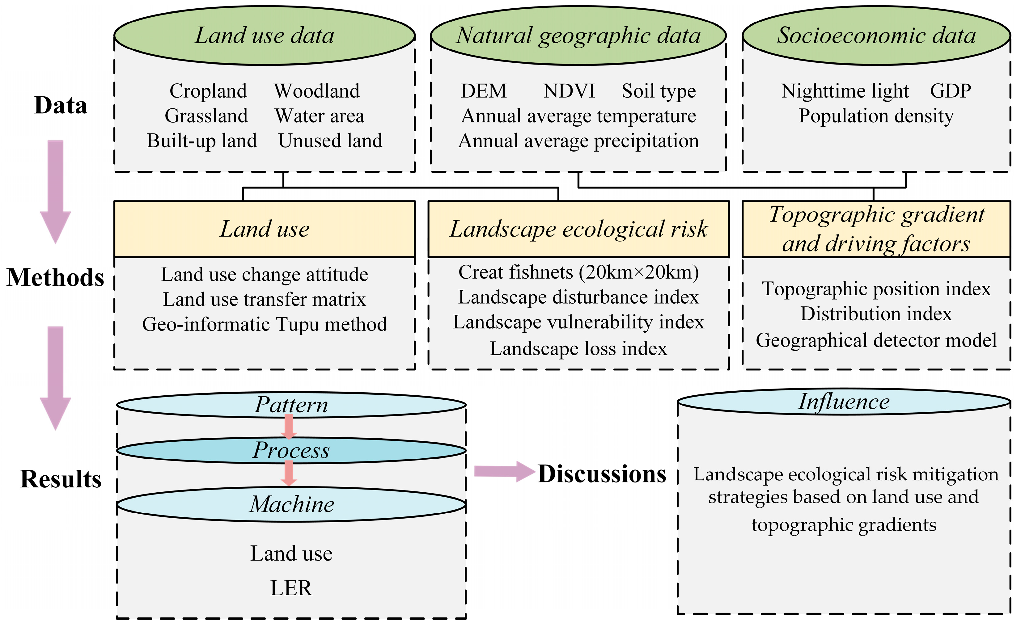
2.3. Methods
2.3.1. Land-Use Change Analysis
2.3.2. Land-Use Transfer Matrix
2.3.3. Geoinformatic Tupu Method
2.3.4. Establishment of the Landscape Ecological Risk Assessment Model
2.3.5. Topographic Position Index
2.3.6. Distribution Index
2.3.7. Geodetector
3. Results
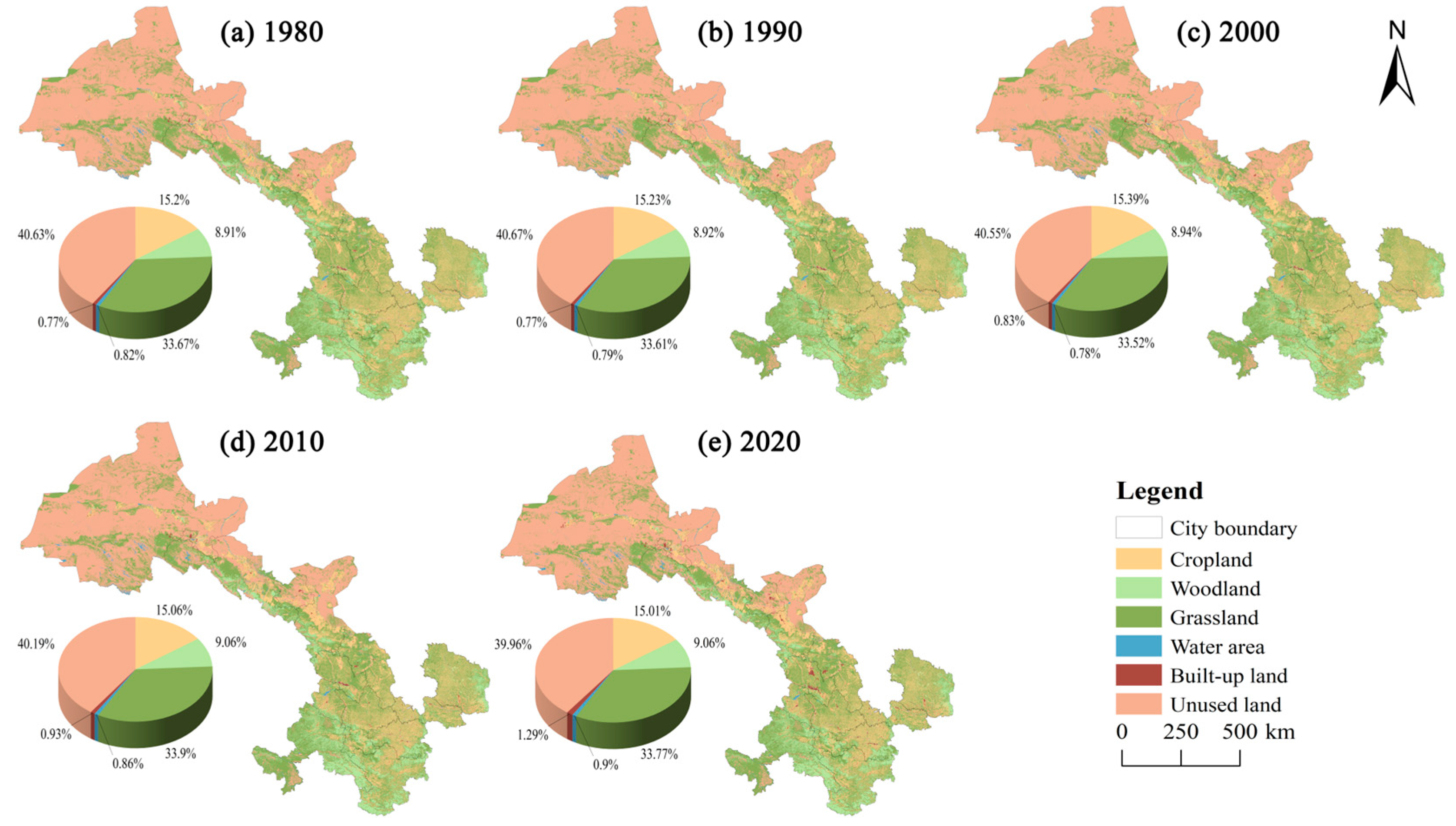
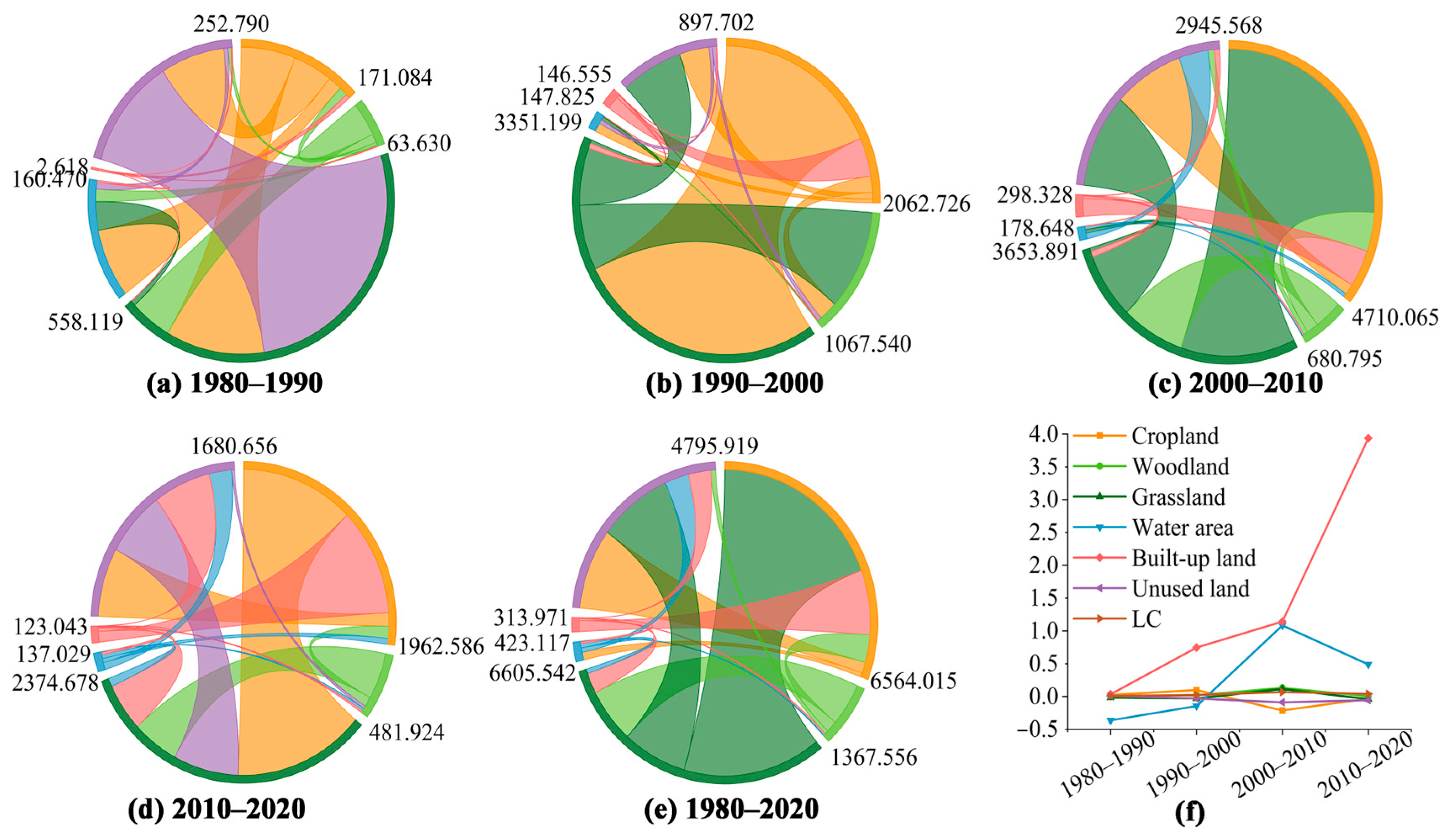
3.1. Spatial and Temporal Distributions and Changes in Land-Use Types under Different Topographic Gradients
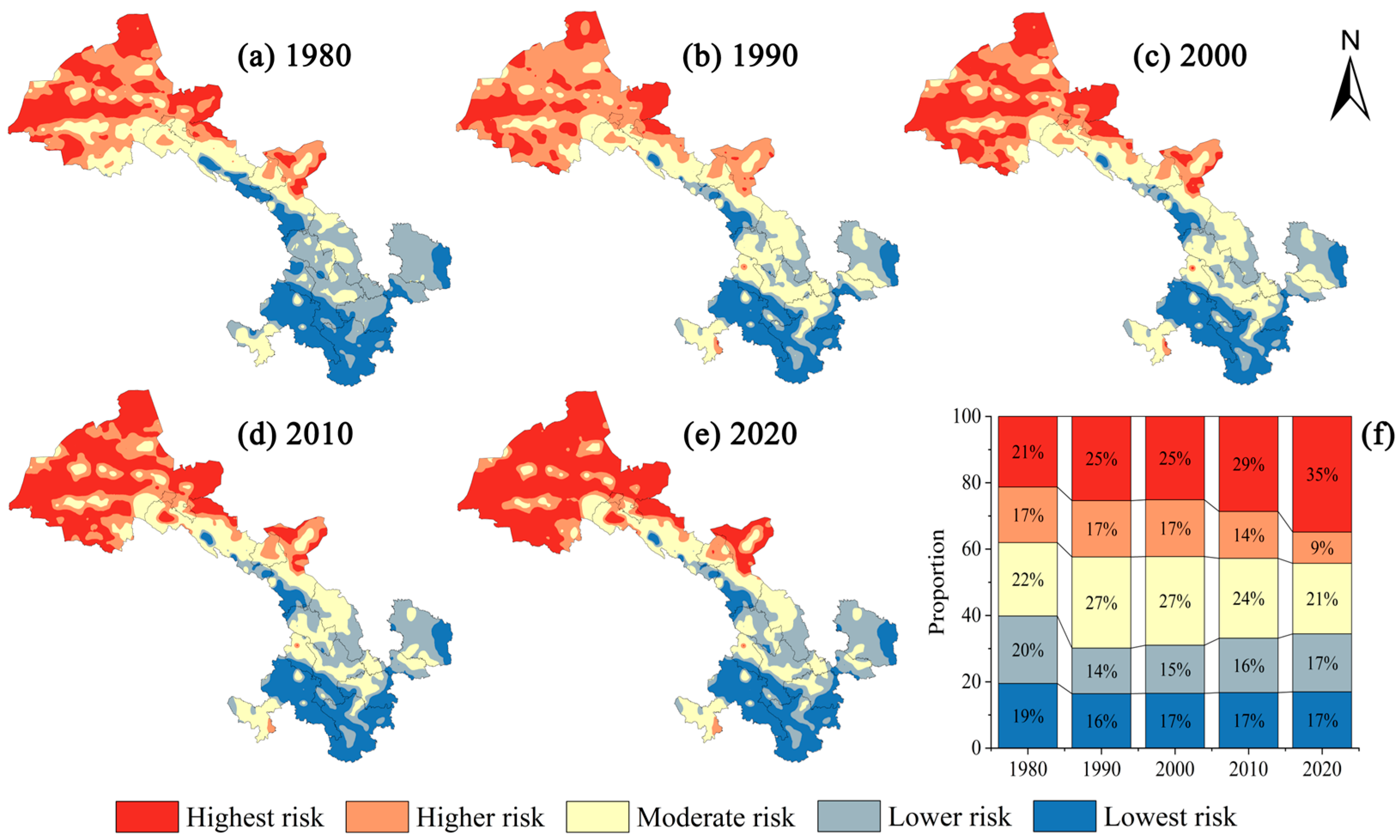
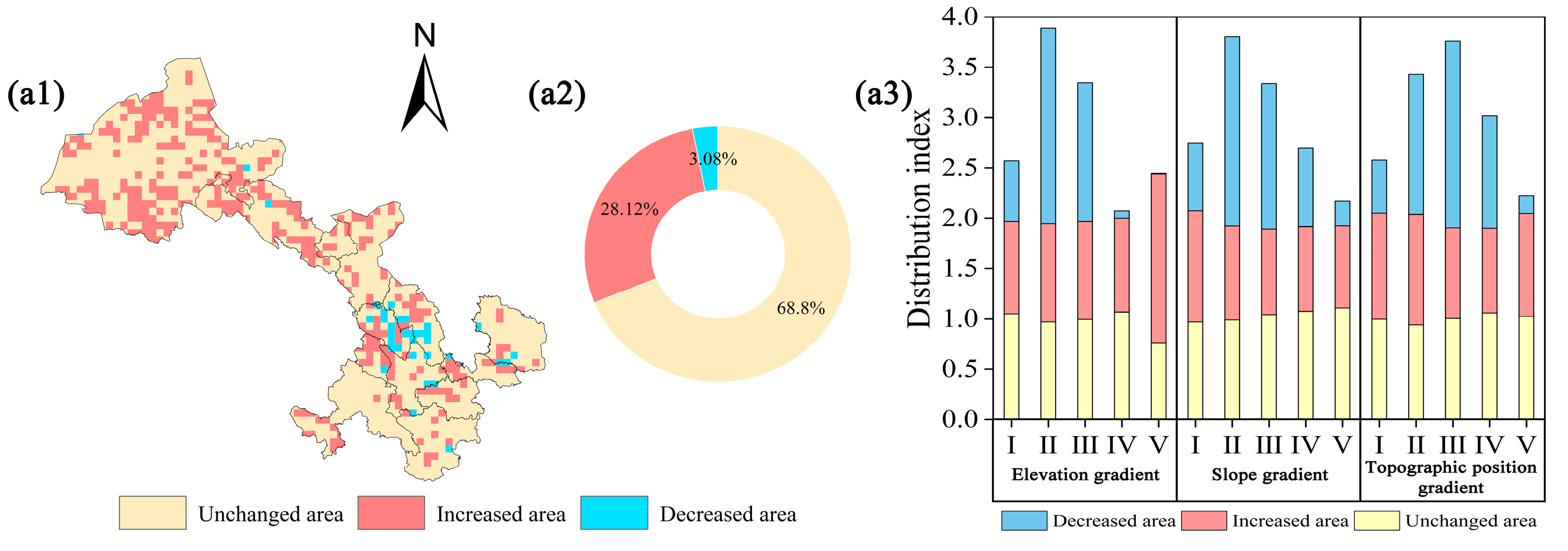
3.2. Spatial and Temporal Distribution and Changes in Landscape Ecological Risk under Different Topographic Gradients
3.3. Drivers of Landscape Ecological Risk under Different Topographic Position Gradients
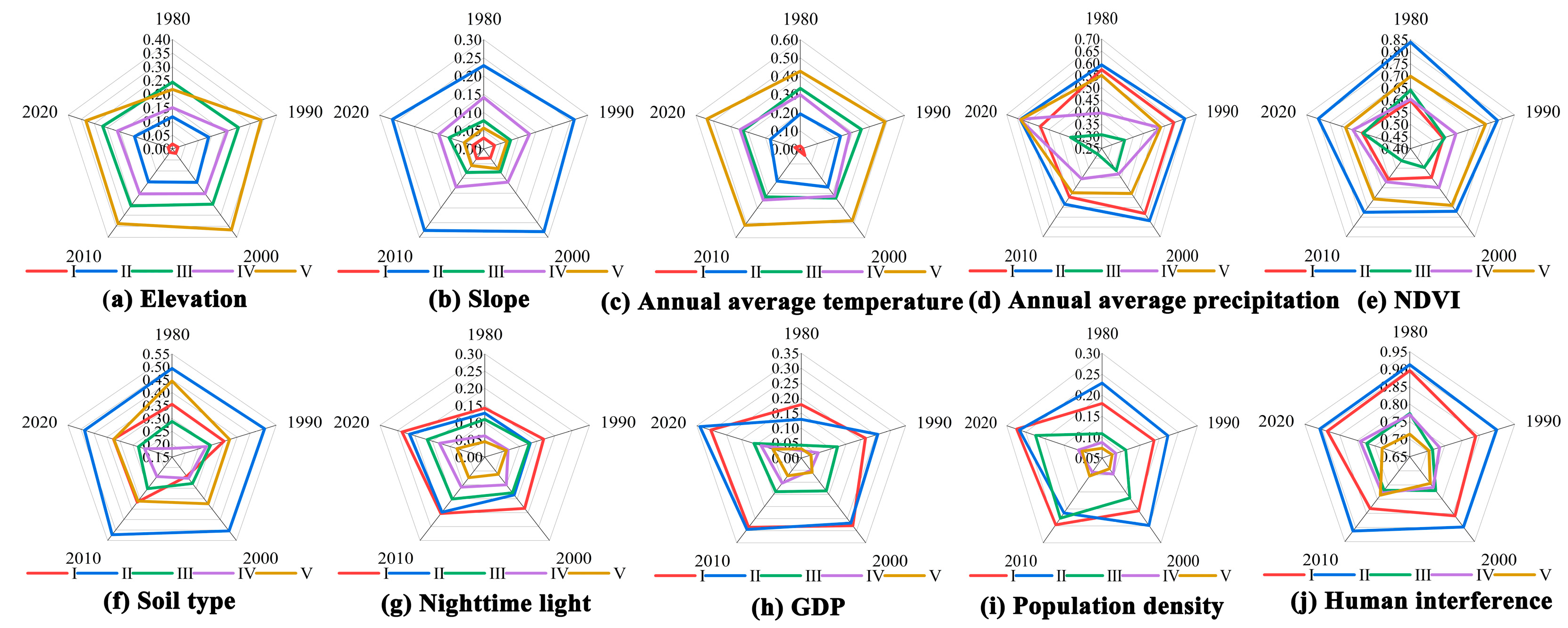
3.3.1. Single-Factor Detection
3.3.2. Interaction Detection
4. Discussion
4.1. Land-Use Change under Different Topographic Gradients
4.2. Landscape Ecological Risk and Drivers under Different Topographic Gradients
4.3. Landscape Ecological Risk Mitigation Strategies Based on Land Use and Topographic Gradients
4.4. Limitations and Prospects
5. Conclusions
Author Contributions
Funding
Data Availability Statement
Conflicts of Interest
References
- Qi, X.T.; Zhang, Z.M.; Jing, J.Y.; Hu, W.H.; Zhao, X. Regional planning for ecological protection of rivers in highly urbanized areas. Ecol. Indic. 2023, 149, 110158. [Google Scholar] [CrossRef]
- Zhang, Z.; Hu, B.Q.; Jiang, W.G.; Qiu, H.H. Construction of ecological security pattern based on ecological carrying capacity assessment 1990–2040: A case study of the Southwest Guangxi Karst—Beibu Gulf. Ecol. Model. 2023, 479, 110322. [Google Scholar] [CrossRef]
- Zhang, L.B.; Wang, H.; Zhang, W.T.; Wang, C.; Bao, M.T.; Liang, T.; Liu, K.D. Study on the development patterns of ecological civilization construction in China: An empirical analysis of 324 prefectural cities. J. Clean. Prod. 2022, 367, 132975. [Google Scholar] [CrossRef]
- Xu, X.L.; Dong, J.W. Assessing the effects of topographic gradients on landscape patterns: The study case of Tingjiang river basin, China. Heliyon 2023, 9, e17619. [Google Scholar] [CrossRef] [PubMed]
- Xue, L.Q.; Zhu, B.L.; Wu, Y.P.; Wei, G.H.; Liao, S.M.; Yang, C.B.; Wang, J.; Zhang, H.; Ren, L.; Han, Q. Dynamic projection of ecological risk in the Manas River basin based on terrain gradients. Sci. Total Environ. 2019, 653, 283–293. [Google Scholar] [CrossRef]
- Peng, J.; Dang, W.X.; Liu, Y.X.; Zong, M.L.; Hu, X.X. Review on landscape ecological risk assessment. Acta Geogr. Sin. 2015, 70, 664–677. [Google Scholar] [CrossRef]
- Tang, P.Z.; Liu, J.Z.; Lu, H.W.; Wang, Z.; He, L. Information-based Network Environ Analysis for Ecological Risk Assessment of heavy metals in soils. Ecol. Model. 2017, 344, 17–28. [Google Scholar] [CrossRef]
- Wang, H.F.; Rao, E.M.; Xiao, Y.; Yan, Y.; Lu, H.T.; Zhu, J.Y. Ecological risk assessment in Southwest China based on multiple risk sources. Acta Ecol. Sin. 2018, 38, 8992–9000. [Google Scholar] [CrossRef]
- Allen, T.F.H. Hierarchy Theory in Ecology. Encycl. Ecol. (Second Ed.) 2008, 1, 606–611. [Google Scholar] [CrossRef]
- Liu, D.; Chen, H.; Zhang, H.; Geng, T.W.; Shi, Q.Q. Spatiotemporal Evolution of Landscape Ecological Risk Based on Geomorphological Regionalization during 1980-2017: A Case Sudy of Shaanxi Province, China. Sustainability 2020, 12, 941. [Google Scholar] [CrossRef]
- Zhang, C.Q.; Zhang, B.A.; Li, W.H.; Liu, M.C. Response of streamflow to climate change and human activity in Xitiaoxi river basin in China. Hydrol. Process. 2014, 28, 43–50. [Google Scholar] [CrossRef]
- Zeng, W.T.; He, Z.W.; Bai, W.Q.; He, L.; Chen, X.; Chen, J.H. Identification of ecological security patterns of alpine wetland grasslands based on landscape ecological risks: A study in Zoigê County. Sci. Total Environ. 2024, 928, 172302. [Google Scholar] [CrossRef] [PubMed]
- La Rosa, D.; Martinico, F. Assessment of hazards and risks for landscape protection planning in Sicily. J. Environ. Manag. 2013, 127, S155–S167. [Google Scholar] [CrossRef] [PubMed]
- Lu, J.Z.; Lu, H.W.; Wang, W.P.; Feng, S.S.; Lei, K.W. Ecological risk assessment of heavy metal contamination of mining area soil based on land type changes: An information network environ analysis. Ecol. Model. 2021, 455, 109633. [Google Scholar] [CrossRef]
- Mann, D.; Anees, M.M.; Rankavat, S.; Joshi, P.K. Spatio-temporal variations in landscape ecological risk related to road network in the Central Himalaya. Hum. Ecol. Risk Assess. 2021, 27, 289–306. [Google Scholar] [CrossRef]
- Karimian, H.; Zou, W.M.; Chen, Y.L.; Xia, J.Q.; Wang, Z.R. Landscape ecological risk assessment and driving factor analysis in Dongjiang river watershed. Chemosphere 2022, 307, 135835. [Google Scholar] [CrossRef] [PubMed]
- Yan, J.X.; Li, G.; Qi, G.P.; Qiao, H.Q.; Nie, Z.G.; Huang, C.X.; Kang, Y.X.; Sun, D.Y.; Zhang, M.H.; Kang, X.; et al. Landscape ecological risk assessment of farming-pastoral ecotone in China based on terrain gradients. Hum. Ecol. Risk Assess. 2021, 27, 2124–2141. [Google Scholar] [CrossRef]
- Liang, Y.; Song, W. Integrating potential ecosystem services losses into ecological risk assessment of land use changes: A case study on the Qinghai-Tibet Plateau. J. Environ. Manag. 2022, 318, 115607. [Google Scholar] [CrossRef]
- Duan, H.L.; Yu, X.B.; Zhang, L.; Xia, S.X.; Liu, Y.; Mao, D.H.; Zhang, G.S. An evaluating system for wetland ecological risk: Case study in coastal mainland China. Sci. Total Environ. 2022, 828, 154535. [Google Scholar] [CrossRef] [PubMed]
- Proshad, R.; Uddin, M.; Idris, A.M.; Al, M.A. Receptor model-oriented sources and risks evaluation of metals in sediments of an industrial affected riverine system in Bangladesh. Sci. Total Environ. 2022, 838, 156029. [Google Scholar] [CrossRef] [PubMed]
- Ai, J.W.; Yu, K.Y.; Zeng, Z.; Yang, L.Q.; Liu, Y.F.; Liu, J. Assessing the dynamic landscape ecological risk and its driving forces in an island city based on optimal spatial scales: Haitan Island, China. Ecol. Indic. 2022, 137, 108771. [Google Scholar] [CrossRef]
- Bao, T.T.; Wang, R.F.; Song, L.H.; Liu, X.J.; Zhong, S.W.; Liu, J.; Yu, K.Y.; Wang, F. Spatio-Temporal Multi-Scale Analysis of Landscape Ecological Risk in Minjiang River Basin Based on Adaptive Cycle. Remote Sens. 2022, 14, 5540. [Google Scholar] [CrossRef]
- Zhao, L.; Shi, Z.T.; He, G.X.; He, L.; Xi, W.F.; Jiang, Q. Land Use Change and Landscape Ecological Risk Assessment Based on Terrain Gradients in Yuanmou Basin. Land 2023, 12, 1759. [Google Scholar] [CrossRef]
- Gan, L.; Halik, U.; Shi, L.; Welp, M. Ecological risk assessment and multi-scenario dynamic prediction of the arid oasis cities in northwest China from 1990 to 2030. Stoch. Environ. Res. Risk A 2023, 37, 3099–3115. [Google Scholar] [CrossRef]
- Wang, Z.Y.; Shi, P.J.; Shi, J.; Zhang, X.B.; Yao, L.T. Research on Land Use Pattern and Ecological Risk of Lanzhou–Xining Urban Agglomeration from the Perspective of Terrain Gradient. Land 2023, 12, 996. [Google Scholar] [CrossRef]
- Kapustka, L.A.; Galbraith, H.; Luxon, M.; Yocum, J. Using landscape ecology to focus ecological risk assessment and guide risk management decision-making. Toxicol. Ind. Health 2001, 17, 236–246. [Google Scholar] [CrossRef]
- Estoque, R.C.; Murayama, Y.; Lasco, R.D.; Myint, S.W.; Pulhin, F.B.; Wang, C.Y.; Ooba, M.; Hijioka, Y. Changes in the landscape pattern of the La Mesa Watershed—The last ecological frontier of Metro Manila, Philippines. For. Ecol. Manag. 2018, 430, 280–290. [Google Scholar] [CrossRef]
- Li, S.K.; He, W.X.; Wang, L.; Zhang, Z.; Chen, X.Q.; Lei, T.C.; Wang, S.J.; Wang, Z.Z. Optimization of landscape pattern in China Luojiang Xiaoxi basin based on landscape ecological risk assessment. Ecol. Indic. 2023, 146, 109887. [Google Scholar] [CrossRef]
- Zhang, X.M.; Du, H.M.; Wang, Y.; Chen, Y.; Ma, L.; Dong, T.X. Watershed landscape ecological risk assessment and landscape pattern optimization: Take Fujiang River Basin as an example. Hum. Ecol. Risk Assess. 2021, 27, 2254–2276. [Google Scholar] [CrossRef]
- Ju, H.R.; Niu, C.Y.; Zhang, S.R.; Jiang, W.; Zhang, Z.H.; Zhang, X.L.; Yang, Z.Y.; Cui, Y.R. Spatiotemporal patterns and modifiable areal unit problems of the landscape ecological risk in coastal areas: A case study of the Shandong Peninsula, China. J. Clean. Prod. 2021, 310, 127522. [Google Scholar] [CrossRef]
- Song, Q.; Hu, B.F.; Peng, J.; Bourennane, H.; Biswas, A.; Opitz, T.; Shi, Z. Spatio-temporal variation and dynamic scenario simulation of ecological risk in a typical artificial oasis in northwestern China. J. Clean. Prod. 2022, 369, 133302. [Google Scholar] [CrossRef]
- Eccles, K.M.; Pauli, B.D.; Chan, H.M. The Use of Geographic Information Systems for Spatial Ecological Risk Assessments: An Example from the Athabasca Oil Sands Area in Canada. Environ. Toxicol. Chem. 2019, 38, 2797–2810. [Google Scholar] [CrossRef] [PubMed]
- Wang, Y.P.; Xu, Z.H.; Yu, S.Y.; Xia, P.; Zhang, Z.M.; Liu, X.B.; Wang, Y.L.; Peng, J. Exploring watershed ecological risk bundles based on ecosystem services: A case study of Shanxi Province, China. Environ. Res. 2024, 245, 118040. [Google Scholar] [CrossRef] [PubMed]
- Birhane, E.; Ashfare, H.; Fenta, A.A.; Hishe, H.; Gebremedhin, M.A.; G. wahed, H.; Solomon, N. Land use land cover changes along topographic gradients in Hugumburda national forest priority area, Northern Ethiopia. Remote Sens. Appl. 2019, 13, 61–68. [Google Scholar] [CrossRef]
- Chen, Y.Y.; Duo, L.H.; Zhao, D.X.; Zeng, Y.; Guo, X.F. The response of ecosystem vulnerability to climate change and human activities in the Poyang lake city group, China. Environ. Res. 2023, 233, 116473. [Google Scholar] [CrossRef] [PubMed]
- Mirghaed, F.A.; Souri, B. Contribution of land use, soil properties and topographic features for providing of ecosystem services. Ecol. Eng. 2023, 189, 106898. [Google Scholar] [CrossRef]
- Wu, J.H.; Wang, G.Z.; Chen, W.X.; Pan, S.P.; Zeng, J. Terrain gradient variations in the ecosystem services value of the Qinghai-Tibet Plateau, China. Glob. Ecol. Conserv. 2022, 34, e02008. [Google Scholar] [CrossRef]
- Li, M.Y.; Zhou, Y.; Xiao, P.N.; Tian, Y.; Huang, H.; Xiao, L. Evolution of habitat quality and its topographic gradient effect in northwest hubei province from 2000 to 2020 based on the invest model. Land 2021, 10, 857. [Google Scholar] [CrossRef]
- Shi, Z.H.; Ma, L.B.; Zhang, W.B.; Gong, M. Differentiation and correlation of spatial pattern and multifunction in rural settlements considering topographic gradients: Evidence from Loess Hilly Region, China. J. Environ. Manag. 2022, 315, 115127. [Google Scholar] [CrossRef] [PubMed]
- Goldsmith, G.R.; Bentley, L.P.; Shenkin, A.; Salinas, N.; Blonder, B.; Martin, R.E.; Castro-Ccossco, R.; Chambi-Porroa, P.; Diaz, S.; Enquist, B.J.; et al. Variation in leaf wettability traits along a tropical montane elevation gradient. New Phytol. 2017, 214, 989–1001. [Google Scholar] [CrossRef] [PubMed]
- Chen, S.S.; Ma, M.H.; Wu, S.J.; Tang, Q.Q.; Wen, Z.F. Topography intensifies variations in the effect of human activities on forest NPP across altitude and slope gradients. Environ. Dev. 2023, 45, 100826. [Google Scholar] [CrossRef]
- Zhao, X.J.; Wang, J.; Su, J.D.; Sun, W.; Jin, W.Q. Assessment of habitat quality and degradation degree based on InVEST model and Moran index in Gansu Province, China. Trans. Chin. Soc. Agric. Eng. 2020, 36, 301–308. [Google Scholar] [CrossRef]
- Niu, Y.Q.; Wang, S.L. Research of the coupling relationship between the vulnerable ecological environment and poverty in Gansu Province. Acta Ecol. Sin. 2017, 37, 6431–6439. [Google Scholar] [CrossRef]
- Sun, B.; Wu, Y.K.; Yan, B.B.; Niu, J.Q. Spatiotemporal variations and impacts on cultivated land resources in Huaihe Eco-Economic Belt during 1990–2020. Trans. Chin. Soc. Agric. Eng. 2023, 39, 247–258. [Google Scholar] [CrossRef]
- Wang, Y.L.; Liang, D.D.; Wang, J.; Zhang, Y.J.; Chen, F.; Ma, X.Y. An analysis of regional carbon stock response under land use structure change and multi-scenario prediction, a case study of Hefei, China. Ecol. Indic. 2023, 151, 110293. [Google Scholar] [CrossRef]
- Yao, L.T.; Zhang, X.B.; Luo, J.; Li, X.H. Identification of Ecological Management Zoning on Arid Region from the Perspective of Risk Assessment. Sustainability 2023, 15, 9046. [Google Scholar] [CrossRef]
- Chen, W.X.; Zhao, H.B.; Li, J.F.; Zhu, L.J.; Wang, Z.Y.; Zeng, J. Land use transitions and the associated impacts on ecosystem services in the Middle Reaches of the Yangtze River Economic Belt in China based on the geo-informatic Tupu method. Sci. Total Environ. 2020, 701, 134690. [Google Scholar] [CrossRef]
- Zhang, H.R.; Zhang, J.N.; Lv, Z.Z.; Yao, L.J.; Zhang, N.; Zhang, Q. Spatio-Temporal Assessment of Landscape Ecological Risk and Associated Drivers: A Case Study of the Yellow River Basin in Inner Mongolia. Land 2023, 12, 1114. [Google Scholar] [CrossRef]
- Zhang, X.B.; Shi, P.J.; Luo, J.; Liu, H.L.; Wei, W. The Ecological Risk Assessment of Arid Inland River Basin at the Landscape Scale: A Case Study on Shiyang River Basin. J. Nat. Resour. 2014, 29, 410–419. [Google Scholar] [CrossRef]
- Gong, W.F.; Wang, H.B.; Wang, X.F.; Fan, W.Y.; Stott, P. Effect of terrain on landscape patterns and ecological effects by a gradient-based RS and GIS analysis. J. For. Res. 2017, 28, 1061–1072. [Google Scholar] [CrossRef]
- Ren, Y.; Zhang, B.; Chen, X.D.; Liu, X.J. Analysis of spatial-temporal patterns and driving mechanisms of land desertification in China. Sci. Total Environ. 2024, 909, 168429. [Google Scholar] [CrossRef] [PubMed]
- Guo, J.P.; Shen, B.B.; Li, H.X.; Wang, Y.D.; Tuvshintogtokh, I.; Niu, J.M.; Potter, M.A.; Li, Y.H. Past dynamics and future prediction of the impacts of land use cover change and climate change on landscape ecological risk across the Mongolian plateau. J. Environ. Manag. 2024, 355, 120365. [Google Scholar] [CrossRef] [PubMed]
- Duan, X.M.; Han, M.; Kong, X.L.; Sun, J.X.; Zhang, H.X. Spatiotemporal evolution and simulation prediction of ecosystem carbon storage in the Yellow River Basin before and after the grain for green project. Chin. J. Environ. Sci. 2024, 1–18. [Google Scholar] [CrossRef]
- Meng, C.; Wu, C.Y.; Wu, J.; Zhang, Q.; Xin, L.; Li, J.X.; Li, D.Z.; Song, C.H. Spatiotemporal changes of coastal land use land cover and its drivers in Shanghai, China between 1989 and 2015. Ocean Coast. Manag. 2023, 244, 106802. [Google Scholar] [CrossRef]
- Franco-Solís, A.; Montanía, C.V. Dynamics of deforestation worldwide: A structural decomposition analysis of agricultural land use in South America. Land Use Policy 2021, 109, 105619. [Google Scholar] [CrossRef]
- Pang, G.J.; Dong, X.F.; Song, X.; Li, B.; Ma, R.L. Remote sensing monitoring of forest land change in Hexi Corridor since construction of the Three-North shelterbelt project. China Desert 2012, 32, 539–544. [Google Scholar]
- Navas, A.; Gaspar, L.; Quijano, L.; Lopez-Vicente, M.; Machín, J. Patterns of soil organic carbon and nitrogen in relation to soil movement under different land uses in mountain fields (South Central Pyrenees). Catena 2012, 94, 43–52. [Google Scholar] [CrossRef]
- Tong, X.W.; Wang, K.L.; Brandt, M.; Yue, Y.M.; Liao, C.J.; Fensholt, R. Assessing future vegetation trends and restoration prospects in the karst regions of southwest China. Remote Sens. 2016, 8, 357. [Google Scholar] [CrossRef]
- Wilson, J.W.; Sexton, J.O.; Jobe, R.T.; Haddad, N.M. The relative contribution of terrain, land cover, and vegetation structure indices to species distribution models. Biol. Conserv. 2013, 164, 170–176. [Google Scholar] [CrossRef]
- Yuan, Y.; Fang, G.H.; Lu, C.X.; Yan, M. Flood risk assessment under the background of urbanization based on landscape ecology. Acta Geogr. Sin. 2020, 75, 1921–1933. [Google Scholar] [CrossRef]
- Li, J.J.; Lü, Z.M.; Shi, X.P.; Li, Z. Spatiotemporal variations analysis for land use in Fen River Basin based on terrain gradient. Trans. Chin. Soc. Agric. Eng. 2016, 32, 230–236. [Google Scholar] [CrossRef]
- Zhang, B.Q.; Wu, P.T.; Zhao, X.N.; Wang, Y.B.; Gao, X.D. Changes in vegetation condition in areas with different gradients (1980–2010) on the Loess Plateau, China. Environ. Earth Sci. 2013, 68, 2427–2438. [Google Scholar] [CrossRef]
- Chen, Q.T.; Yin, H.R.; Li, Y.H.; Dong, Q.D.; Zhang, P.P.; Zhu, L.Q. Spatial and temporal differentiation of landscape ecological risk in Qinling-Daba Mountains. Bull. Soil Water Conserv. 2022, 42, 239–246. [Google Scholar] [CrossRef]
- Li, M.R.; Abuduwailia, J.; Liu, W.; Feng, S.; Saparov, G.; Ma, L. Application of geographical detector and geographically weighted regression for assessing landscape ecological risk in the Irtysh River Basin, Central Asia. Ecol. Indic. 2024, 158, 111540. [Google Scholar] [CrossRef]
- Lin, X.; Wang, Z.T. Landscape ecological risk assessment and its driving factors of multi-mountainous city. Ecol. Indic. 2023, 146, 109823. [Google Scholar] [CrossRef]
- Gong, J.; Yang, J.X.; Tang, W.W. Spatially Explicit Landscape-Level Ecological Risks Induced by Land Use and Land Cover Change in a National Ecologically Representative Region in China. Int. J. Environ. Res. Public Health 2015, 12, 14192–14215. [Google Scholar] [CrossRef] [PubMed]
- Gao, B.P.; Li, C.; Wu, Y.M.; Zhen, K.J.; Wu, Y. Landscape ecological risk assessment and influencing factors in ecological conservation area in Sichuan-Yunnan provinces, China. Chin. J. Appl. Ecol. 2021, 32, 1603–1613. [Google Scholar] [CrossRef] [PubMed]
- Wang, C.X.; Yu, C.Y.; Chen, T.Q.; Feng, Z.; Hu, Y.C.; Wu, K.N. Can the establishment of ecological security patterns improve ecological protection? An example of Nanchang, China. Sci. Total Environ. 2020, 740, 140051. [Google Scholar] [CrossRef] [PubMed]





| Category | Data | Type | Year | Spatial Resolution | Data Resource |
|---|---|---|---|---|---|
| Land-use data | Land use | Vector | 1980–2020 | 30 m | Resource and Environment Science and Data Center (http://www.resdc.cn/) (accessed on 12 November 2022) |
| Natural geographic data | DEM | Raster | 2020 | 30 m | Geospatial Data Cloud (http://www.gscloud.cn/) (accessed on 12 November 2022) |
| Annual average temperature | Raster | 1980–2020 | 1000 m | National Earth System Science Data Center (http://www.geodata.cn/) (accessed on 12 November 2022) | |
| Annual average precipitation | Raster | 1980–2020 | 1000 m | ||
| NDVI | Raster | 1980–2020 | 1000 m | Resource and Environment Science and Data Center (http://www.resdc.cn/) (accessed on 13 November 2022) | |
| Soil type | Raster | 1995 | 1000 m | ||
| Socioeconomic data | Nighttime light | Raster | 1980–2020 | 0.008°/0.004° | Resource and Environment Science and Data Center (http://www.resdc.cn/) (accessed on 13 November 2022) |
| GDP | Raster | 1980–2020 | 1000 m | ||
| Population density | Raster | 1980–2020 | 1000 m |
| Level 1 Type | Secondary Type | |
|---|---|---|
| Name | Connotation | Name |
| Cropland | Refers to land used for growing crops, including mature, cultivated land, newly opened land, recreational land, rotational land, grassland rotational cropland; land used mainly for growing crops for agriculture and fruit, agriculture and mulberry, and agriculture and forestry; and beach land and mudflats that have been cultivated for more than three years. | Paddy land, dryland. |
| Woodland | Refers to forestry land where trees, shrubs, bamboo, and coastal mangroves grow. | Wooded land, shrubland, open woodland, other wooded land. |
| Grassland | Refers to all types of grassland with a predominantly herbaceous growth and a cover of 5% or more, including scrub grassland with a predominantly pastoral growth and open grassland with a depression of less than 10%. | High cover grassland, medium cover grassland, low cover grassland. |
| Water area | Refers to natural terrestrial waters and water facility lands. | Canals, lakes, reservoirs, pits and ponds, permanent glacial snow, mudflats, shoals. |
| Built-up land | Refers to urban and rural settlements and land for industry, mining, transportation, etc., outside of them. | Town land, rural settlement land, other construction land. |
| Unused land | Currently unutilized land, including hard–to–utilize land. | Sandy, Gobi, saline, marshy, bare land, bare rocky terrain, other. |
| Method | Calculation Formula | Variable Interpretation | Connotation |
|---|---|---|---|
| K | Where K is the dynamic attitude of a certain land-use type in the study period; Up is the total area of a certain land-use type at the beginning of the study period; Uq is the total area of a certain land-use type at the end of the study period; and T is the time interval between them. | Reflects the rapidity of the rate of change in a particular land-use type during a certain period. | |
| LC | Where |ΔUq−p| denotes the area of land-use type p converted to land-use type q (non–p) during the study period. | Reflects the rapidity of the combined rate of change in multiple land-use types within a certain period. | |
| Land-use transfer matrix | Where Spq denotes the area of the pth land-use type converted to the qth land-use type and k is the number of land-use types. | Reflects the transformation of land-use types in a region between the areas at the beginning and end of a given period. | |
| Topographic position index | Where T is the topographic position index; E and S are the elevation and slope, respectively, at any point in the study area; and and are the mean elevation and mean slope, respectively, of the study area. | The greater the elevation and the greater the slope are, the greater the topographic position index, and vice versa. | |
| Distribution index | Where P is the distribution index, i is the land-use type/LER level, e is the topographic gradient level, A is the total area of the study area, Aie is the area of the ith land-use type/LER level on the eth topographic gradient, Ai is the area of the ith land-use type/LER level, and Ae is the area of the eth topographic gradient. | Reflects the distribution of different land-use types/LER levels across the topographic gradient. When P > 1, under a certain terrain factor, the ith land-use type/LER level in the e–level topographic gradient area has a dominant distribution, and the larger the P value is, the greater the dominance. | |
| Geodetector | Where q is the detection value for drivers of LER, taking the value of [0, 1], N is the number of evaluation units in the whole domain, Nz is the zth evaluation unit, L is the number of driver categories, and and are the variances of the LER values for the zth evaluation unit and the whole domain, respectively. | The q–statistics were calculated and compared by factor detection in a geodetector to analyze the magnitude of the explanatory power of each driver for the spatial divergence of LER. Interaction testing was utilized to determine whether two factors interacted and to assess whether the drivers jointly enhanced or weakened the explanatory power of the spatial divergence of LER. |
| Index | Calculation Formula | Variable Interpretation | Connotation and Ecological Significance |
|---|---|---|---|
| Landscape fragmentation index (Ci) | Where ni is the number of patches of landscape type i; Ai is the area of landscape type i. | Ci is used to reflect the fragmentation degree of the landscape ecosystem. It indicates the process of landscape type changing from a continuous whole patch to complex discontinuous patches under natural or human disturbance. The larger the value, the higher the fragmentation degree, the more significant the human interference and the lower the internal stability. | |
| Landscape separation index (Ni) | Where A is the total area of the landscape type. | Ni indicates the degree of separation between different patches in the landscape type. Li is the ratio of the area of landscape type i to the total area of the evaluation unit. The larger the value is, the more complex the spatial distribution of the landscape type is and the higher the separation degree is. | |
| Landscape dominance index (Di) | Where Qi is the frequency of plaques, which indicates the ratio of the number of sample areas where plaque i appears to the total number of sample areas; Mi is the density of plaques, which indicates the ratio of the number of plaques i to the total number of plaques. | Di indicates the importance of patches in the landscape, and its magnitude directly reflects the size of the patches’ influence on the formation and change of the landscape pattern. The higher the value of this value, the more dominant its landscape type and the higher the degree of dominance of patches in the landscape pattern. | |
| Landscape disturbance index (Ei) | Where a, b, and c are the weights of Ci, Ni, and Di, and a + b + c = 1, assigning values of 0.5, 0.3, and 0.2. | Ei indicates the degree of disturbance of different landscape types within the study area. The larger the value, the greater the degree of disturbance and the higher the ecological risk. | |
| Landscape vulnerability index (Fi) | Referring to the previous research result [5,16,49], each land-use type was assigned a value and then normalized | The vulnerability of 6 types of land use in the study area was graded: unused land = 6, water area = 5, cropland = 4, grassland = 3, woodland= 2, built-up land = 1, and the vulnerability index of each landscape type was normalized, which was 0.286, 0.238, 0.190, 0.143, 0.095 and 0.048, respectively. | Fi indicates the vulnerability of the ecosystems represented by different landscape types to external disturbances. The higher the value, the weaker the ability to resist external disturbances and the higher the ecological risk. |
| Landscape loss index (Ri) | Where Ei is the landscape disturbance index; Fi is the landscape vulnerability index. | Ri indicates the extent to which the ecosystems represented by different landscape types are disturbed by both natural and man-made disturbances. | |
| Landscape ecological risk index (LERI) | Where LERIi is the ith risk index of risk communities; Aki is the area of the k-risk community category i landscape; Ak is the area of the k-risk community; Ri is the landscape loss index of the type i landscape. | Establishes a link between land-use change and landscape ecological risk and reflects the level of landscape ecological risk in the study area. |
| Gradient Level | I | II | III | IV | V |
|---|---|---|---|---|---|
| Elevation | 1578–1625 m | 1625–2240 m | 2240–2991 m | 2991–3773 m | 3773–5821 m |
| Slope | 0–4.36° | 4.36°–10.76° | 10.76°–18.03° | 18.03°–26.75° | 26.75°–74.14° |
| Topographic position index | 0.11–0.36 | 0.36–0.55 | 0.55–0.73 | 0.73–0.93 | 0.93–1.51 |
Disclaimer/Publisher’s Note: The statements, opinions and data contained in all publications are solely those of the individual author(s) and contributor(s) and not of MDPI and/or the editor(s). MDPI and/or the editor(s) disclaim responsibility for any injury to people or property resulting from any ideas, methods, instructions or products referred to in the content. |
© 2024 by the authors. Licensee MDPI, Basel, Switzerland. This article is an open access article distributed under the terms and conditions of the Creative Commons Attribution (CC BY) license (https://creativecommons.org/licenses/by/4.0/).
Share and Cite
Zhang, X.; Yu, J.; Feng, H.; Yao, L.; Li, X.; Du, H.; Liu, Y. Landscape Ecological Risk and Drivers of Land-Use Transition under the Perspective of Differences in Topographic Gradient. Land 2024, 13, 876. https://doi.org/10.3390/land13060876
Zhang X, Yu J, Feng H, Yao L, Li X, Du H, Liu Y. Landscape Ecological Risk and Drivers of Land-Use Transition under the Perspective of Differences in Topographic Gradient. Land. 2024; 13(6):876. https://doi.org/10.3390/land13060876
Chicago/Turabian StyleZhang, Xuebin, Jiale Yu, Haoyuan Feng, Litang Yao, Xuehong Li, Hucheng Du, and Yanni Liu. 2024. "Landscape Ecological Risk and Drivers of Land-Use Transition under the Perspective of Differences in Topographic Gradient" Land 13, no. 6: 876. https://doi.org/10.3390/land13060876
APA StyleZhang, X., Yu, J., Feng, H., Yao, L., Li, X., Du, H., & Liu, Y. (2024). Landscape Ecological Risk and Drivers of Land-Use Transition under the Perspective of Differences in Topographic Gradient. Land, 13(6), 876. https://doi.org/10.3390/land13060876


