Article

Spatiotemporal Evolution of Habitat Quality and Scenario Modeling Prediction in the Tuha Region

1
College of Geography and Remote Sensing Sciences, Xinjiang University, Urumqi 830046, China
2
Xinjiang Key Laboratory of Oasis Ecology, Xinjiang University, Urumqi 830046, China
*
Author to whom correspondence should be addressed.
Land 2024, 13(7), 1005; https://doi.org/10.3390/land13071005
Submission received: 5 June 2024 / Revised: 3 July 2024 / Accepted: 5 July 2024 / Published: 7 July 2024

Abstract

:
In recent years, increasing urbanization has profoundly impacted the quality of regional habitats, presenting a severe risk to the ability of a region to develop in a high-quality manner. Therefore, the scientific assessment of the features of habitat quality (HQ) evolution over time and space and the prediction of future trends in changes in the HQ are of great significance for the formulation of effective ecological protection policies. Based on five periods of land use and land cover (LULC) data from 2000 to 2020, InVEST model was used to estimate both geographical and chronological trends in the HQ in the Tuha region, China. Spatial autocorrelation analysis methods were used to assess HQ and spatial aggregation of habitat degradation, and ecological zoning was delineated in conjunction with the Human Footprint Index (HFI). Based on the results of ecological zoning, the study predicted changes in habitat quality (HQ) in 2040 under three scenarios: natural development (ND), ecological preservation (EP), and urban development (UD) by applying the Patch-Generating Land Use Simulation (PLUS) model. The results demonstrated that (1) from 2000 to 2020, the habitat quality in the Tuha region exhibited a downward trend, with the proportion of low HQ increasing from 83.63% to 84.24%. Spatially, high habitat quality (HQ) is mainly concentrated in the Tianshan Mountains. From 2000 to 2020, the Moran index for habitat quality (HQ) decreased from 0.967 to 0.959, while the Moran index for habitat degradation declined from 0.805 to 0.780. The habitat quality (HQ) and degradation exhibit significant spatial aggregation, and the degree of degradation has increased incrementally. (2) From 2000 to 2020, human activities in the Tuha area increased continuously and were mainly concentrated in Tuha district and counties. The proportion of high Human Footprint Index (HFI) increased from 0.66% to 1.32%, while the proportion of medium HFI increased from 3.13% to 7.46%. (3) The expansion of urbanized land has exacerbated habitat degradation. The proportion of high HQ in the EP scenario is higher than that in ND and UD scenario. The results show that the ecological protection scenario is more conducive to the sustainable development of habitat quality in the Tuha region. The results can provide a scientific basis for ecological management and protection in the Tuha area.

1. Introduction

As crucial elements of ecosystems, habitats offer the space and supplies needed for individual plant and animal populations to survive and grow [1]. Habitat quality (HQ), the ability and potential of ecosystems to offer living circumstances that support the sustainable growth of the people or communities, is a crucial indicator of the sustainability and ecological health of a region [2]. With the rapid growth of global urbanization and population, human activities have more and more impact on the natural environment. HQ is an important part of the ecosystem and is highly susceptible to external human interference. For example, urbanization has dramatically changed regional habitat distribution patterns and functions [3], urban expansion [4,5], human activity [6,7], and land use [8]. The emphasis on high-quality regional development in the context of the new era is vital not only for the construction of modern socialist power, but also for building a community for human destiny. Therefore, analyzing and assessing the present and future HQ of the Tuha region plays an important role in achieving the sustainable development of regional ecological security.
Domestic and international studies assessing HQ focused on ecological and geographic perspectives [9], and based on LULC data [10], are present in the literature. Assessment models combining remote sensing, GIS, and other technological tools are also widely used [11]. Among these, the spatial expression of the InVEST model and its ease of use, adaptability, and robust output findings have made it a popular choice for research applications [12]. The capacity of the InVEST Habitat Quality (HQ) module to quickly and precisely assess regional habitat quality based on changes in land use and land cover (LULC) and the level of stress on biodiversity makes it a useful tool [13]. Therefore, most studies have used the InVEST model to assess habitat quality in study areas [14,15] and biosphere reserves [16]. There are also studies redefining [17] habitat quality and applying the InVEST model to freshwater HQ [18].
With the emergence and continuous optimization of LULC simulation models, some studies combined HQ assessment models with land-use simulation models. For example, Gao [19] and other scholars coupled the FLUS and CA-Markov models for multiple scenario simulations and employed the InVEST model to assess the HQ. Zheng [20] predicted the trend in HQ change in the studied location by applying the coupled FLUS-InVEST model. Compared to the above models, the PLUS model has the advantages of identifying the drivers of the land expansion process, as well as higher simulation accuracy [21], so it is widely used by scholars. Most studies predict and evaluate the spatial-temporal evolution of land use and habitat quality by coupling the PLUS and InVEST models [22]. However, some studies prefer to use PLUS and InVEST models to simulate land use and habitat quality under different scenarios [23].
Natural and human factors have important effects on habitat quality. Some studies have revealed the impact of habitat quality on land use and vegetation cover through a vegetation index [24]. Other studies have used geographic mapping [25] and remote sensing data [26] to explore the impact of land use on habitat quality. There are also studies [13,27,28] using DEM, meteorological, land use, vegetation composition, and soil data [29] to analyze the evolution and influencing factors of habitat quality. As human activities increase, the impact of human factors on habitat quality cannot be ignored. With the development of methods for evaluating human activities, the Human Footprint Index has been widely employed to analyze the impact of human activities on habitat quality [30]. Furthermore, the Human Footprint Index method is integrated with HQ, offering a novel perspective for ecological zoning and the delineation of functional areas. This method is not only applied to the functional zoning of national parks [31], but is also utilized to evaluate the conservation effectiveness of protected areas worldwide [32]. Although research on habitat quality, based on the above methods, has made considerable progress, it still needs to be further explored. Therefore, the InVEST, Human Footprint Index (HFI), and PLUS models were applied to assess and predict habitat quality.
It is of great significance to evaluate and predict the habitat quality in Tuha region. First, the ecosystems of the Tuha region and northwest China are more fragile and sensitive than those of other regions. Secondly, the Tuha region is an important oasis-type city on the Silk Road Economic Belt. It is important to evaluate the spatial and temporal variation of HQ for the Tuha region and other regions with similar natural conditions. There is a large area of unused land in Tuha area. The existence of large tracts of unused land makes our research have more important practical significance and theoretical value. By assessing the habitat quality of unused land, the regional ecosystem health can be more accurately understood, and scientific basis can be provided for the formulation of corresponding ecological protection and management strategies. At the same time, this study can provide useful reference and enlightenment for regional ecological protection and restoration.
We focused on the Tuha region and used LULC data to assess the HQ of the area. The InVEST model was employed in combination with the HFI to conduct ecological zoning planning. The PLUS model was introduced to predict the changes in HQ under three scenarios—natural development (ND), ecological preservation (EP), and urban development (UD). The research objectives of this study were as follows: (1) to analyze the changing trend in habitat quality and to explore the spatial aggregation of habitat quality and habitat degradation and (2) to determine which scenario is more conducive to the sustainable development of habitat quality in the future. The research results can provide scientific basis and guidance for realizing effective ecological restoration and regional sustainable development in Tuha region.

2. Materials and Methods
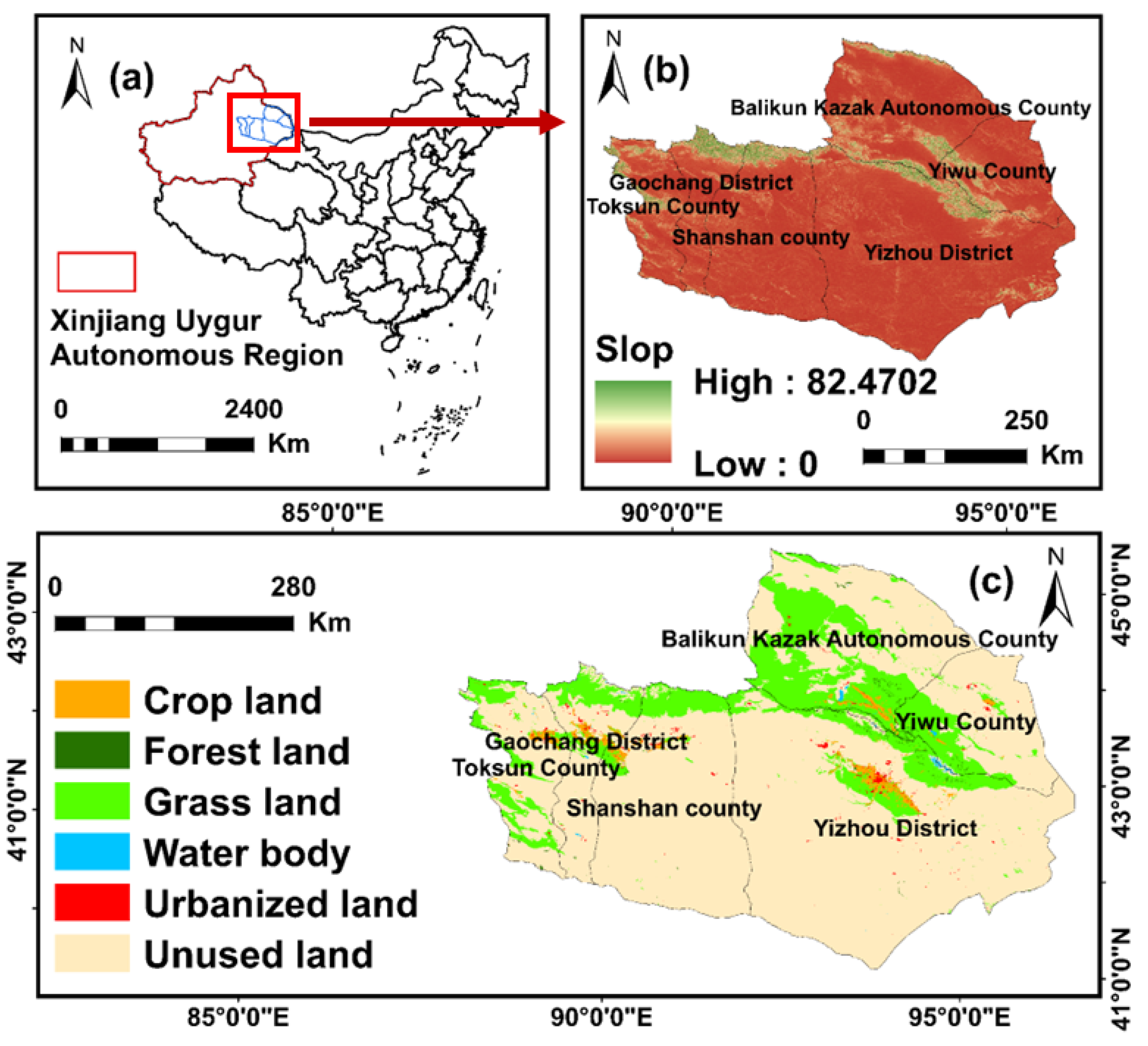
2.1. Study Area

The Tuha region (87°16′ E–96°23′ E, 40°52′ N–45°05′ N) comprises the Turpan and Hami Prefectures, including Gaochang District, Shanshan County, Toksun County, Yizhou District, Balikun Kazak Autonomous County, and Yiwu County. It serves as the Eastern entry point from Xinjiang to mainland China, located in the Eastern portion of the Xinjiang Uygur Autonomous Region, which is rich in oil and other mineral resources. It is an important city in the “Silk Road Economic Belt” region. It is mainly characterized by a temperate continental arid climate, with an annual precipitation of 47.5 mm and an annual evaporation of 2712.6 mm, respectively, where annual evaporation significantly exceeds annual precipitation. The regional terrain is divided by the Tianshan Mountain Range, which is high in the center and low in the north and south. Tuha region is of great significance to the adjustment of ecosystem balance and the construction of ecological security barrier in Xinjiang [33] (Figure 1).

2.2. Data and Preprocessing

Table 1 shows the data sources for this paper. Among them, we divided the LULC data into six classes: crop land, forest land, grass land, water body, urbanized land, and unused land. Slope data were obtained based on the DEM data. The distance to roads and railroads was calculated using the European Distance Tool.

2.3. Methods

2.3.1. InVEST Model

Threat factor weights and the sensitivity of different land-use types to threat factors were combined using the HQ module of the InVEST model, which evaluates the HQ using LULC data. Equation (1) was followed which may be written as follows:
Q x j = H j ( 1 ( D x j z D x j z + k z ) )
where Qxj stands for the land-use type j grid’s headquarters. Hj stands for the habitat appropriateness of the land-use type j. Dxj is the hazard level of grid x in land-use type j, and the half-saturation constant is denoted by k and z equals 2.5. The following formula was used to determine the degree of threat in D x j  (2):
D x j = r = 1 R y = 1 Y r ( w r r = 1 R w r ) r y i r x y β x S j r
where the variables wr and irxy represent the weight of each danger element r, influence of danger r in raster y on habitat x, and the accessibility level of grid x, respectively, and Sjr represents the danger factor r-sensitivity of land use type j.
Based on the actual conditions of the Tuha region and incorporating Wang’s [36] research in the Xinjiang region, crop land, urbanized land, and unused land were selected as the primary threat considerations for the study area in this research. The InVEST model handbook was referred to ascertain the maximum influence distance, weight, and type of attenuation for the danger components (Table 2).
According to the reference values suggested by the InVEST modeling manual, the habitat suitability of the LULC types in the study area ranged from 0 to 1, with 1 indicating the highest suitability and higher values corresponding to higher HQ values (Table 3).

2.3.2. Spatial Autocorrelation Analysis

Global geographical autocorrelation was chosen to analyze the spatial dependence and aggregation of the degree and quality of habitat destruction. The spatial autocorrelation indices for HQ and degradation were measured globally by resampling the data to a 1 km grid scale using the queen contiguity spatial matrix in GeoDa1.20 software.

2.3.3. Human Footprint Index (HFI) Evaluation

Sanderson [37] introduced the Human Footprint Index (HFI) to assess the extent of human activity and its impacts on biological environments. Considering the current situation in the Tuha region and referring to the research conducted by Zhang [38], Duan [39], and Huang [40], we utilized the HFI method to select four key factors: land use, population density, night lighting, and traffic accessibility to comprehensively describe human activities in the region. The various types of raster data were reassigned according to different evaluation methods, with the understanding that the higher the score, the stronger the intensity of human activities. The HFI was finally obtained by superimposing the factor raster after each assignment. The precise assignment procedure is described as follows:
(1) Land use. In this study, urbanized land was assigned a score of 10, crop land was assigned a score of 7, and all remaining land types were assigned a score of 1.
(2) Population density. Population density visualizes the level of human activity and concentration in an area. This study referred to the method of assigning scores based on population density proposed by Venter [41] and other scholars. Specifically, raster areas with a population density of more than 1000 people/km² were assigned a score of 10, while the remaining raster areas with a population density of less than 1000 people/km² were assigned scores according to the following Equation (3):
p o p s c o r e = 3.333 × log ( p o p d e n s i t y + 1 )
(3) Night lighting. The raster with a DN value equal to 0 was assigned a score of 0, and the remaining raster were categorized into 10 levels according to the natural discontinuity point method, with assigned values ranging from 1 to 10.
(4) Transportation accessibility. The construction of roads and railroads brings convenience to human beings, while also affecting the ecological environment on both sides of the roads. After performing a multi-ring buffer analysis, eight points were awarded within 0.5 km on both sides of the road, four points were awarded within 0.5–1 km, three points were awarded within 1–1.5 km, two points were awarded within 1.5–2 km, one point was awarded within 2–3.5 km, and zero points were awarded for areas beyond 3.5 km. A value of eight points was assigned to the area within 0.5 km on either side of the railroad, while the rest of the area was assigned zero points.

2.3.4. Ecological Zoning

Ecological control is crucial for resolving conflicts between regional ecological supply and demand. Ecological zoning, a key aspect of ecosystem control, is vital in promoting sustainable urban development [42]. Based on the findings of the HQ and HFI grading in 2020, an overlay analysis was performed using the raster calculator tool of ArcGIS 10.6, resulting in nine HQ-HFI spatial types (Figure 2).
Drawing upon earlier studies, such as Wei [43], the nine spatial types were categorized into three main groups: habitat conservation area, habitat restoration area, and moderate development area. Habitat conservation area encompassed High HQ-Low HFI, High HQ-Medium HFI, and Medium HQ-Low HFI. Habitat restoration area included Low HQ-Low HFI, Low HQ-Medium HFI, Low HQ-High HFI, and Medium HQ-High HFI. Lastly, moderate development area comprised Medium HQ-Medium HFI and High HQ-High HFI.

2.3.5. PLUS Model

The Patch-Generating Land Use Simulation (PLUS) model was selected to model future land use in the research area. PLUS is a novel patch generation method for simulating the use of land built on the foundation of a conventional cellular automata (CA) model [44]. The model includes the CA modules for the land expansion analysis strategy (LEAS) and multi-type randomized patch seeding (CARS).
(1)
Driver selection
Land use change is influenced by a diverse range of factors, encompassing natural elements like DEM, slope, temperature, and precipitation, as well as socio-economic factors such as distance from roads and railways, GDP, and population density. Additionally, soil type is also considered in this study (Figure 3).
(2)
Parameterization of domain weights
Weight indicates the intensity of transfer expansion for various land classes. The interval is between [0 and 1], where the closer the weight is to 0, the easier it is for the land class to shift to other land classes, and the closer it is to 1, the less likely it is for the land class to shift to other land classes.
(3)
Accuracy verification
This study simulated LULC in the Tuha region in 2020 based on LULC data from 2000. The Kappa coefficient of 0.9 was obtained when the real land usage in 2020 was compared with the simulated results. This shows that the simulation results are reliable.
(4)
Multi-scenario settings
This study presents three scenarios—ND, EP, and UD. A Markov chain was employed to anticipate the LULC demand in 2040, considering the two periods of LULC data from 2000 to 2020 (Table 4).
(5)
Matrix of transfer costs
The conversion cost matrix illustrates the ease of converting the current land class into the desired one [46]. The transfer cost matrix typically comprises two values: zero and one. A value of 0 indicates that the conversion of the land class to another land class is prohibited, whereas a value of 1 indicates the opposite. In this study, we have set up transformation matrices for different scenarios (Table 5).

3. Results

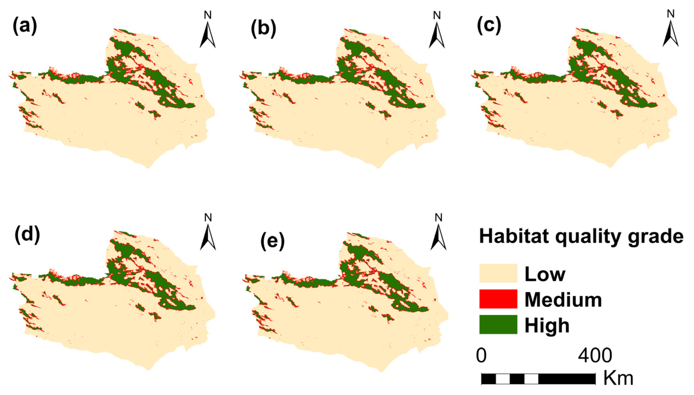
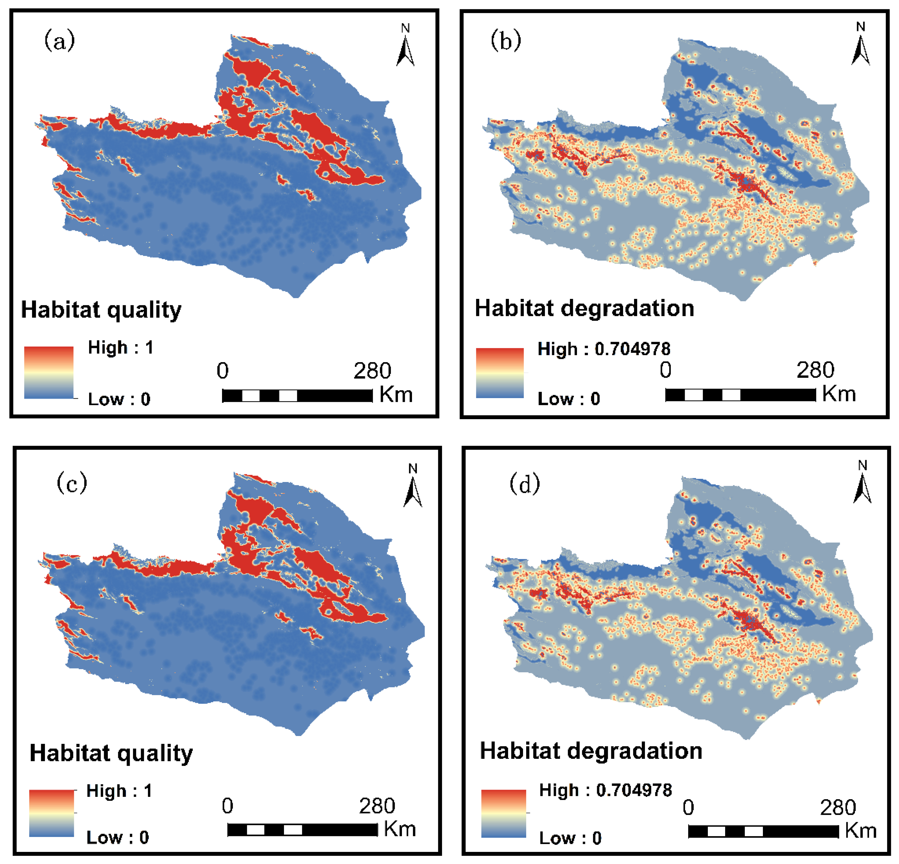
3.1. Spatial and Temporal Distribution of HQ

The habitat quality and its degradation in the Tuha region were evaluated for the years 2000, 2005, 2010, 2015, and 2020, utilizing the InVEST model. The assessment outcomes for habitat quality (HQ) in the region were subsequently categorized into three distinct groups: low (0–0.21), medium (0.21–0.62), and high (0.62–1), applying the method of natural breaks classification. The habitat quality is low in Tuha region, and the proportion of low habitat quality is the largest. From 2000 to 2020, the average habitat quality in the region decreased slightly, from 0.15 to 0.14. Furthermore, the proportions of medium and high habitat quality have also declined, indicating a continuous deterioration of the environment in the Tuha region. Between 2000 and 2020, the proportion of medium habitat quality decreased from 10.97% to 10.45%, while the proportion of high habitat quality declined from 5.40% to 5.30%. During this period, the proportion of low habitat quality increased correspondingly, rising from 83.63% to 84.24% (Figure 4).
A map depicting the shift in habitat quality transfer from 2000 to 2020 (Figure 4) and a table of transfer matrices (Table 6) were produced by superimposing the outcomes of the habitat quality assessments from 2000 to 2020. It is clear from the findings that while keeping their initial classification, less low HQ moved to high HQ and 16.17% moved to medium HQ. The conversion area from medium habitat quality to high habitat quality was 56.04 km2, and the conversion area from medium habitat quality to low habitat quality was 1027.26 km2. A total of 27.17% of high habitat quality was converted to low habitat quality, and 83.83% of high habitat quality was converted to medium habitat quality. High and medium habitat quality were transformed into low habitat quality, accounting for 27.17% and 72.83% of the total, respectively.
Figure 5 shows the habitat quality in the Tuha region. It can be seen from the figure that the habitat quality is high in the central part and low in the Northern and Southern parts. The areas with a high HQ were concentrated along the Tianshan Mountain Range. This region is characterized by long mountain ranges, high vegetation cover, and a high degree of regional and national protection. Additionally, there was a low impact from human activities. The cities of Turpan and Hami demonstrated excellent HQ, due to the flat and open terrain, as well as the high level of anthropogenic vegetation cover. Low HQ is the majority in the Tuha area, mainly due to large unused land and poor natural environment in this area.
Using the method of natural breaks classification, habitat degradation was classified as low (0–0.1), medium (0.1–0.32), and high (0.32–0.7) to further investigate the geographical and temporal changes in HQ in the Tuha region. Temporally, from 2000 to 2020, the percentage of degraded areas in both medium and high habitat degradation showed an increasing trend. Specifically, the percentage of medium habitat degradation increased from 7.19% in 2000 to 9.46% in 2020, whereas the proportion of high habitat degradation rose from 1.10% to 1.20% over the same period. From the perspective of spatial layout, as shown in Figure 6, the high habitat degradation areas in the Tuha region are mainly concentrated in the districts and counties with concentrated population. The area of cultivated land is increasing, as is the area of habitat degradation.

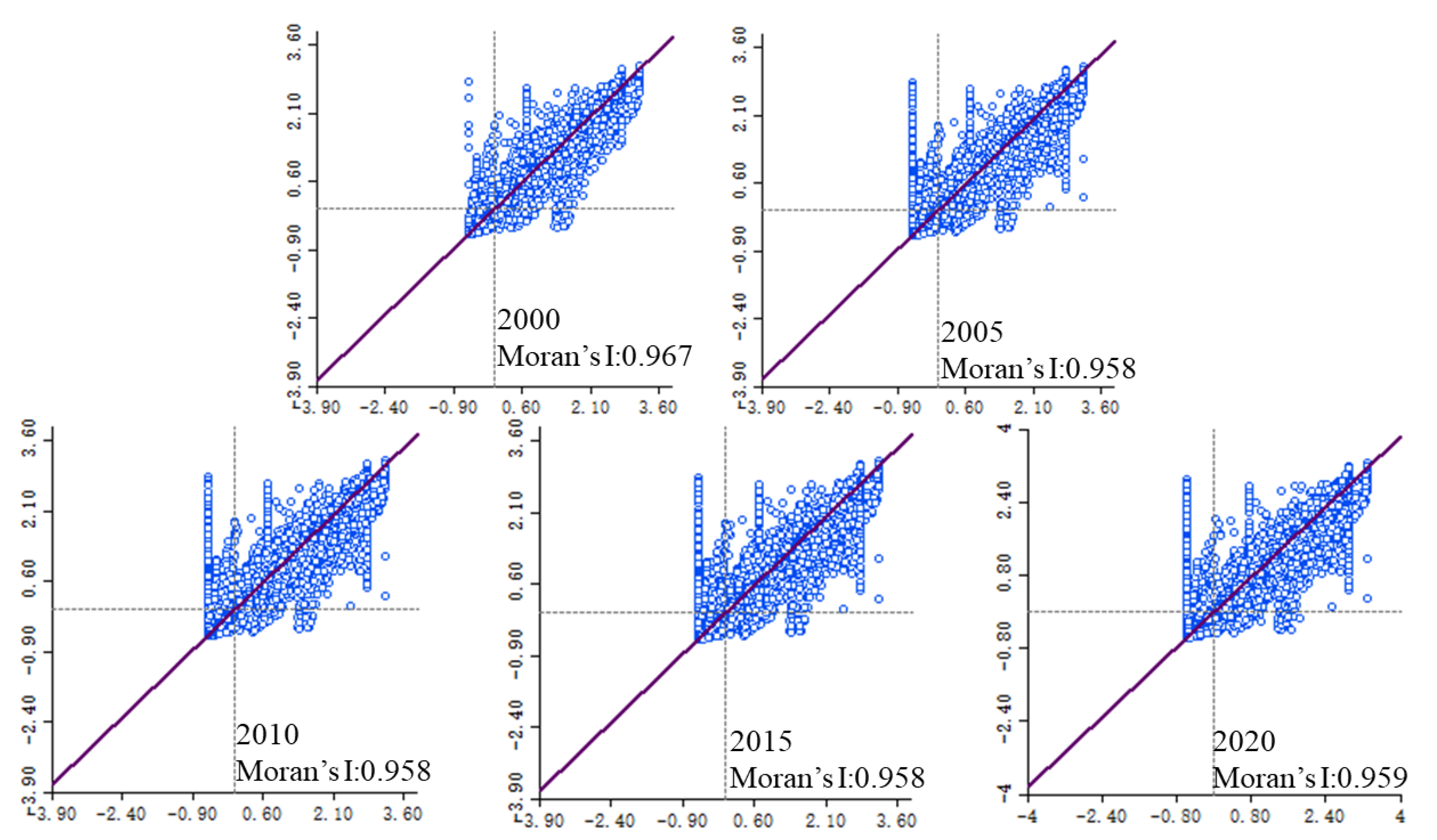
3.2. Spatial Autocorrelation Analysis of HQ and Habitat Degradation

The Moran index was used to explore the geographic aggregation of HQ and its degradation in the Tuha region from 2000 to 2020 (Figure 7).
The Moran index of habitat quality from 2000 to 2020 was 0.967, 0.958, 0.958, 0.958, and 0.959, respectively, all of which were significant at the 0.001 level. During the whole study period, the index was close to 1, indicating that there was a large spatial aggregation of habitat quality in the Tuha region. This is conducive to the centralized protection and management of the ecological environment by human beings.
In the Tuha region, the Moran’s index values of habitat degradation between 2000 and 2020 were 0.805, 0.807, 0.808, 0.779, and 0.780, with p-values of 0.001, passing the 95% confidence score. Habitat degradation was characterized by spatial clustering. This facilitates the centralized ecological restoration of humans.

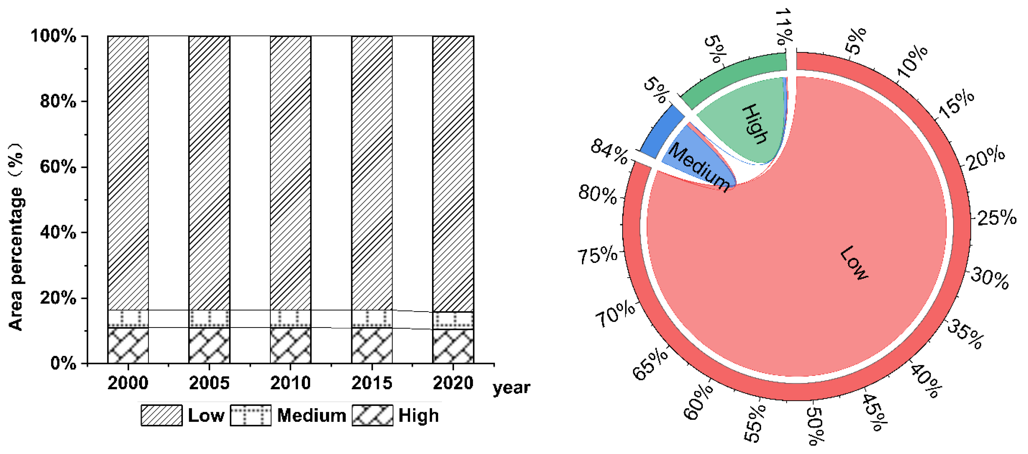
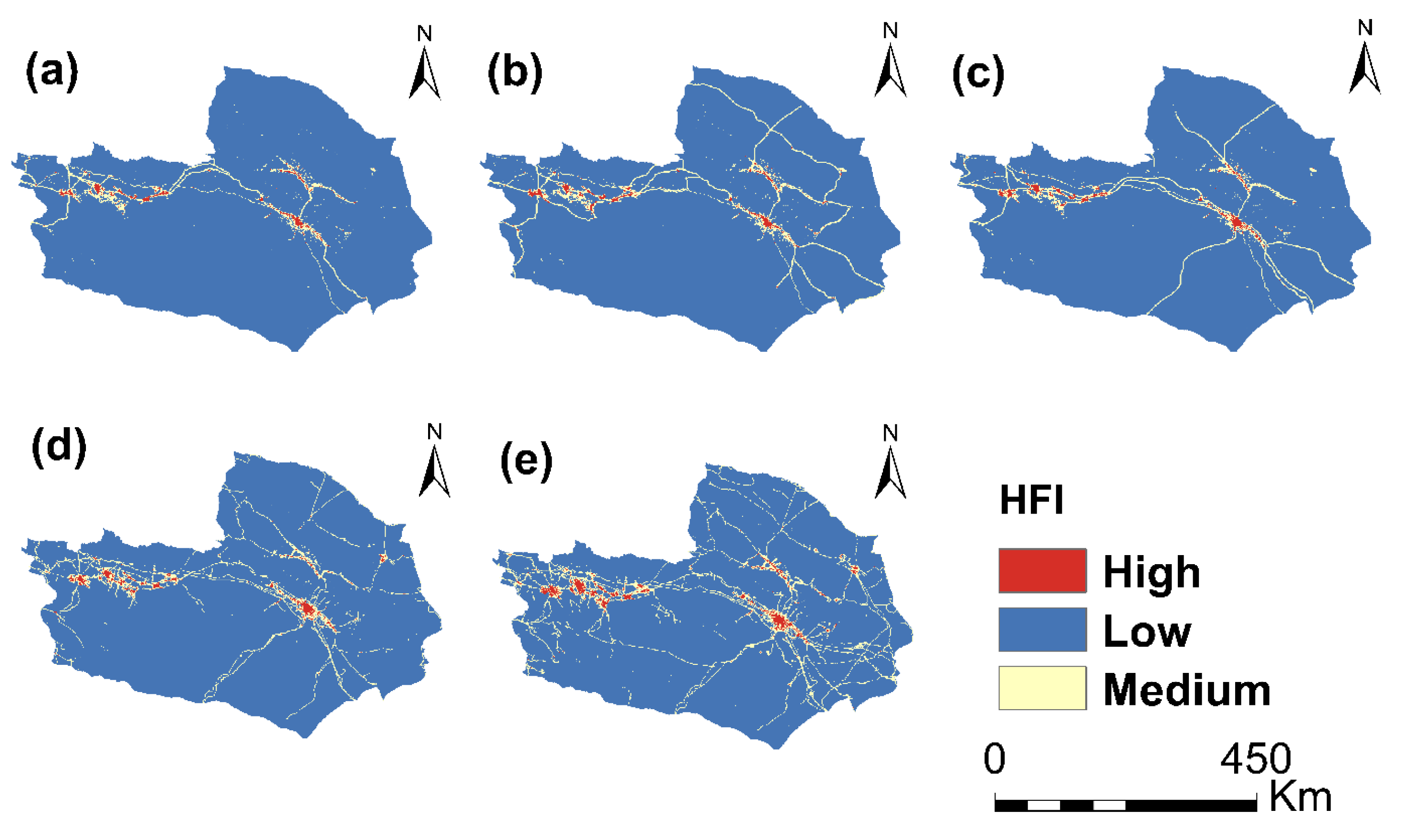
3.3. Spatial and Temporal Distribution Characteristics of the HFI

The HFI results for the Tuha region were analyzed using ArcGIS 10.6 software. The results were divided into low, medium, and high levels based on the method of natural breaks classification. A distribution map of the HFI in the Tuha region was obtained (Figure 8).
The high HFI of the Tuha region grew temporally from 2000 to 2020, with its share increasing from 0.66% to 1.32%. The medium HFI also expanded, increasing in size from 3.13% to 7.46%. Contrarily, the low HFI demonstrated a decreasing trend from 96.20% to 91.22%. With accelerated urbanization, human activities are becoming stronger with increasing reclamation of unused land. This is presented in Table 7.
Spatially, the HFI was observed to be high in the districts and counties of the Tuha region, as well as along roads and railroads. High HFI was confined to narrow regions, primarily inside the counties and districts of Tuha. The area of medium HFI was approximately 3–7%, primarily covering buffer zones along roads to districts and counties as well as to other prefectures and cities, As the economy and tourism industry develop, the number of roads in each region of the Tuha region starts to be significant. The low HFI demonstrated the highest percentage of area, remaining above 90%, and was dominated by unused land (Figure 8).

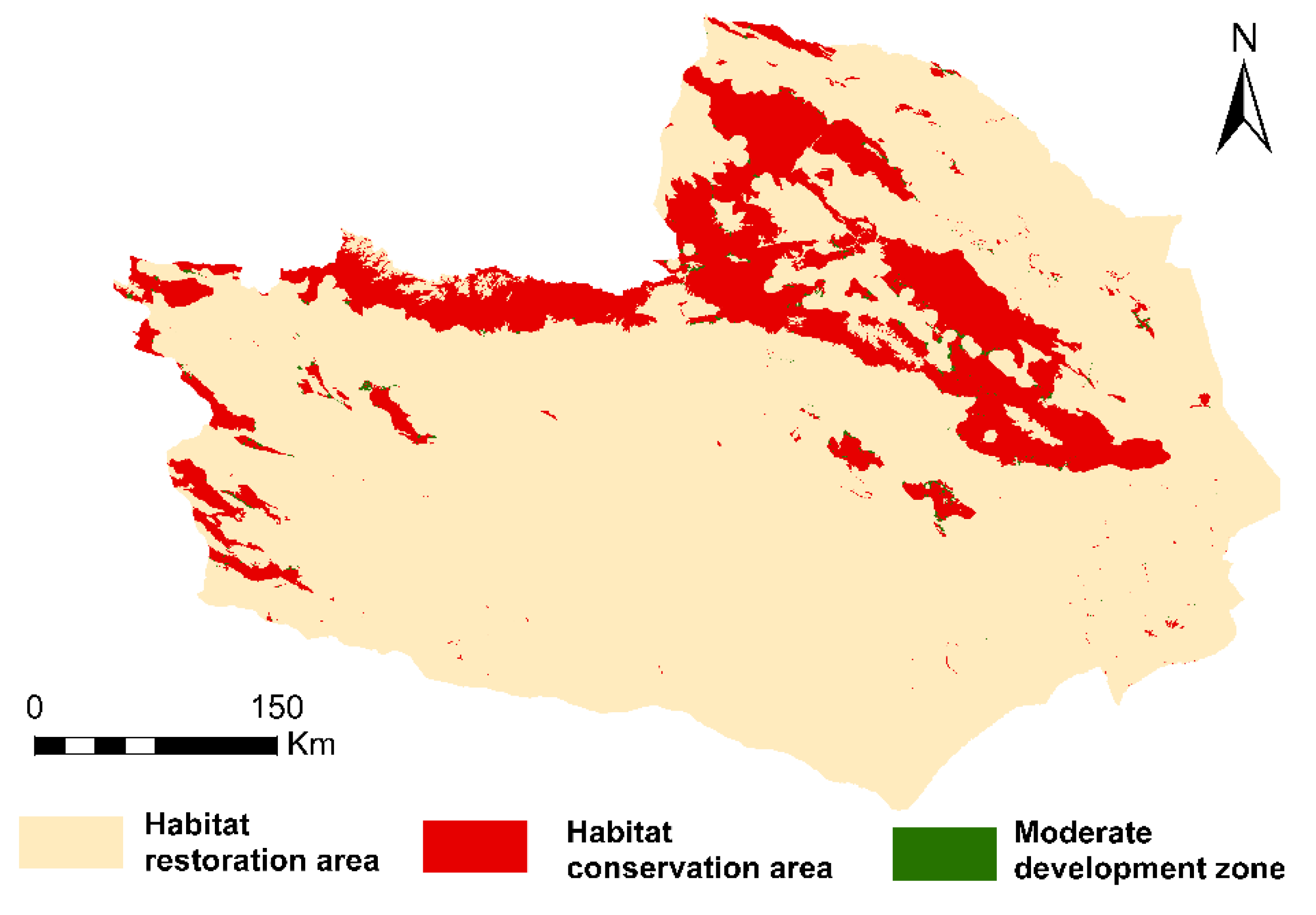
3.4. Results of Ecological Zoning

Figure 9 presents the results of ecological control zoning in the Tuha region based on the previous section. The habitat conservation areas cover 15.43% of the overall size of the Tuha region. The region primarily comprises extensive grassland and forestland and is primarily distributed in areas rated as high HQ.
Habitat restoration areas were observed to cover 84.24% of the study region. The areas outside the protected regions are generally of low HQ and are affected by poor natural conditions and significant human activity.
The moderate development zone covered 0.33% of the total area. This area is sporadic and occurs primarily around habitat conservation areas, which are areas of medium HQ where construction activities may be conducted without destroying HQ.

3.5. Land Use Multi-Scenario Simulation Projections

The land usage of the Tuha region in 2040 (Figure 10) was predicted using the PLUS model under three different scenarios based on the outcomes of ecological zoning—ND, EP, and UD. The LULC data from 2020 were used as the basis for this prediction.
Based on the continuation of the developing natural scenario, the PLUS forecasts demonstrate a significant expansion of the urbanized land area in the Tuha region between 2020 and 2040 (Table 8), with the areas expected to increase by 446 km2 by 2040. The water area maintained a significant increasing trend of 23 km2, which may partly be due to the increase in the number of water storage projects, such as reservoirs in the Tuha region, and the fact that people spend a great deal of money and effort to protect the water resources of the region. Crop land is expected to increase to 341 km2 by 2040. Grassland area decreased by 274 km2. Forest land area increased by 1 km2. Unused land demonstrated a decreasing trend of 536 km2 by 2040. The intensity of the utilization of unused land demonstrated a gradual increase due to the increase in human activities.
The ecological conservation scenarios present a general progression towards excellence in various natural landscapes in the Tuha region. The scenario has far less growth in urbanized land than the ND scenario considering the scenario is formulated with a lower probability of conversion to urbanized land, with an increase of 380 km2 between 2020 and 2040, 66 km2 less than that in the ND scenario. In this scenario, the area of crop land still increased compared to that in 2020, but was 66 km2 less than that in the ND scenario. Forestland continued to exhibit an increasing trend. Grassland increased by 142 km2 compared to that in the ND scenario.
In terms of promoting economic prioritization in the UD scenarios, the urbanized land area was higher than in the ND and EP scenarios, and the share of the urbanized land area increased from 0.69% in the ND scenario to 0.71% in the UD scenario. Owing to an explosion in population and the expansion of cities, the cropland area of Tuha increased by 58 km2 in the UD scenario compared with that in the EP scenario.

3.6. Characterization of Changes in HQ under Different Scenarios

The InVEST model was used to simulate the future HQ of the Tuha region based on LULC data from three scenarios—ND, EP, and UD—as predicted by the simulation in 2040. The modifications in the region and ratio of each grade of HQ were estimated (Table 9) and the spatial distribution was visualized (Figure 11).
According to the study, the average HQ values in 2040 are 0.135, 0.139, and 0.137 for ND, EP, and UD, respectively. The HQ of the Tuha region was observed to generally decline in 2040 compared with that in 2020. The Tuha region was still dominated by areas with poor HQ in 2040. For ND, high-quality habitat areas decreased from 10.45% in 2020 to 10.10% in 2040. This scenario was characterized by accelerated urbanization and the expansion of cities, which have a significant impact on the ecological environment. Under the EP scenario, the proportion of areas with high HQ continued to decline from 10.45% in 2020 to 10.30% in 2040 compared with that of the ND scenario. Compared with that of the other two scenarios, the UD scenario demonstrated the fastest decline in the region with superior habitat, with the percentage of the area falling to 10.06% by 2040.
The HQ of the Tuha region retained its original spatial pattern at the spatial scale, whereas the degradation and quality of the habitat varied across the scenarios. Under the ND scenario, habitat degradation was the most pronounced in the Northern part of the Tuha region and along the Tianshan Mountain Range, where the spatial extent of high-grade HQ decreased. Contrastingly, the extent of degradation was lower in the EP scenario. Spatial extent of habitat degradation resembles the extent of urbanized land expansion in the land-use modeling results.

4. Discussion

4.1. Features of the Changing and Degrading HQ of the Tuha Region

HQ and degradation inside the Tuha area were highly aggregated in the years 2000–2020, and areas of high HQ were primarily concentrated along the Tianshan Mountain Range and in the districts and counties. The Tianshan area may be influenced by national ecological protection policies, and the districts and counties may be the result of local efforts to increase the greening of the region. A high degree of spatial clustering of habitat degradation was also observed, with high values primarily concentrated around counties and districts. The region is flat and geographically well positioned, and land use is predominantly arable and constructed, with strong impacts from human activities, leading to a significant level of habitat deterioration. The rapid expansion of cropland and settlements is closely related to the deterioration of habitat quality [47]. Human activities not only improve the environment, but also lead to the degradation of habitats [26]. Human modification of the landscape results in the degradation of habitat quality [16]. In conclusion, human activities have an important impact on habitat quality. This finding is consistent with that of the results from earlier scholars [48,49]. However, land-use types may have been converted without a timely balance between the LULC types and the ecological environment, leading to habitat degradation. This finding is consistent with that of a study on HQ and degradation by Zhou [50].

4.2. Scenario Modeling and Model

The results of the scenario modeling demonstrated that the normal growth scenario widened the development area of the Tuha region and accelerated the decline in HQ. The habitat state in the EP scenario also demonstrated a downward trend, albeit to a lesser extent. Under the sustainable development scenario, the habitat quality index of the study area was higher [51]. According to the setting of the scenario of returning cropland to forest, the forest area of the study area was enlarged and the habitat quality was high. Therefore, ecological conservation scenarios are conducive to sustainable regional development. This finding is consistent with studies by other scholars [19,52,53,54,55] demonstrating that ecological conservation is more conducive to the development of regional HQ under multi-scenario modeling.
Compared with the technique that builds an indicators system [56] for HQ assessment, the InVEST offers more spatiality, simplicity, and flexibility in its exploration of HQ [57,58]. Additionally, the InVEST model is mostly combined with other models [59,60,61] and is widely used. Human activity is measured in many ways. Contrastingly, Zheng’s [62] research assessed the level of human activity in terms of the urbanized land. Chen’s [63] research characterized human activity based on land use data, combined with population distribution and nighttime lighting data. Li’s [64] study introduced novel data sources, and by constructing spatial feature extraction algorithms as well as indicators of artificial environment and light pollution impacts, human activity zones are clarified and human behaviors are analyzed. The InVEST model can be used as an effective and low-cost decision support tool for nature conservation, leading to a strong integrated land planning and management approach [65]. However, using the HFI method—which incorporates information on land use, population density, nighttime lighting, and transportation accessibility—this study characterized human activities. The four indicators are based on earlier research and fill in the gaps in that research. Human actions can be more precisely characterized by the HFI.
The shortcomings of the study are that the driving factor options of the PLUS model are far too limited. In the future, in addition to the natural aspects, other economic and social factors should be added, including the distance to towns and cities and rivers. This research analyzed and forecasted the features of spatial and temporal variations in HQ in the Tuha region, but ignored the mechanisms influencing the evolution of HQ. Therefore, future research should investigate the determinants of HQ evolution based on field surveys—both natural and humanistic. Simultaneously, several zoning techniques should be explored to improve the ecological control division in the Tuha region.

5. Conclusions

This study evaluated the habitat quality in Tuha region from 2000 to 2020 combining 2020 habitat quality and the HFI designated key protection area, ecological restoration area, and moderate development zone. Based on the results of ecological zoning, the PLUS model was applied to predict the change trend in habitat quality under ND, EP and UD scenarios in 2040. The main results are as follows:
(1)
From 2000 to 2020, the average habitat quality in Tuha area decreased from 0.15 to 0.14. In the past 20 years, the habitat quality in Tuha region was mainly low grade. The proportion of low grade increased from 83.63% to 84.24%. At the same time, the habitat quality of the medium and high grades was transferred to the low grades, accounting for 27.17% and 72.83% respectively. Spatially, high-grade habitat quality is primarily concentrated in the Tianshan Mountains, which is largely influenced by conservation policies and experiences less human disturbance. The low-grade habitat quality is mainly distributed in districts and counties, which is caused by urban development.
(2)
From 2000 to 2020, the global Moran’s index values for HQ were demonstrated to be above 0.95 and significant at the 0.001 level, and the habitat degradation index values were all above 0.75, passing the 95% confidence evaluation. This suggests that HQ and degradation are spatially clustered and dependent, conducive to ecological protection and ecological restoration.
(3)
From 2000 to 2020, the proportion of high HFI increased, whereas the proportion of low HFI decreased, falling from 96.20% to 91.22%. Spatially, high HFI is predominantly concentrated in districts, counties, as well as along highways and railways. Conversely, low HFI is mainly found in vast areas of unutilized land.
(4)
In the ND scenario, the proportion of high HQ is 10.10% in 2040. In the EP scenario, the proportion of high HQ is 10.30% in 2040. In the UD scenario, the proportion of high HQ is 10.06% in 2040. Compared to the ND and UD scenarios, the habitat degradation under the EP scenario is less severe, making it more conducive to the sustainable development of habitat quality in the Tuha area.
Proper planning by the government is of great importance for realizing the sustainable development of the regional ecological environment. Therefore, in connection with the ecological protection scenario, the government should strictly control urban expansion areas, vigorously conduct ecological restoration work, reasonably establish an ecological security pattern, and harmonize the relationship between economic development and environmental protection to promote the high-quality development in the region.
Furthermore, distinct conservation initiatives for the quality of habitats in various sub-zones must exist. For example, regions and states must focus on controlling habitat protection zones, strictly preventing human activities that threaten the ecological environment, and safeguarding the stability of regional habitats. National policies and integrated ecological restoration strategies for mountains, water, forests, fields, lakes, grasses, and sands must be closely followed by the conservation of habitat regions. This will gradually enhance the natural surroundings and achieve long-term growth in the Tuha area.

Author Contributions

Conceptualization, methodology, software, formal analysis, writing—original draft: J.W.; funding acquisition, supervision: A.A. (Abudukeyimu Abulizi); funding acquisition, supervision: Y.M.; funding acquisition, supervision: K.M.; investigation, formal analysis: L.Y.; investigation, formal analysis: S.B.; writing—review and editing: T.Y.; writing—review and editing: A.A. (Adila Akbar); writing—review and editing: X.Z.; writing—review and editing: F.S. All authors have read and agreed to the published version of the manuscript.

Funding

This research was supported by the Third Xinjiang Scientific Expedition Program (Grant No. 2022xjkk1100).

Data Availability Statement

The data presented in this study are available on request from the corresponding author. The data are not publicly available due to the nature of this research.

Conflicts of Interest

The authors declare no conflicts of interest.

References

  1. Zhao, Y.; Qu, Z.; Zhang, Y.; Ao, Y.; Han, L.; Kang, S.; Sun, Y. Effects of human activity intensity on habitat quality based on nighttime light remote sensing: A case study of Northern Shaanxi, China. Sci. Total Environ. 2022, 851, 158037. [Google Scholar] [CrossRef] [PubMed]
  2. Zhang, G.; Roslan, S.N.A.; Quan, L.; Yuan, P. Simulation of spatiotemporal patterns of habitat quality and driving mechanism in Anhui province, China. Front. Environ. Sci. 2023, 11, 1145626. [Google Scholar] [CrossRef]
  3. Deng, Y.; Jiang, W.; Wang, W.; Lv, J.; Chen, K. Urban expansion led to the degradation of habitat quality in the Beijing-TianjinHebei Area. Acta Ecol. Sin. 2018, 38, 4516–4525. [Google Scholar]
  4. Song, S.; Liu, Z.; He, C.; Lu, W. Evaluating the effects of urban expansion on natural habitat quality by coupling localized shared socioeconomic pathways and the land use scenario dynamics-urban model. Ecol. Indic. 2020, 112, 106071. [Google Scholar] [CrossRef]
  5. Tang, J.; Zhou, L.; Dang, X.; Hu, F.; Yuan, B.; Yuan, Z.; Wei, L. Impacts and predictions of urban expansion on habitat quality in the densely populated areas: A case study of the Yellow River Basin, China. Ecol. Indic. 2023, 151, 110320. [Google Scholar] [CrossRef]
  6. Yuan, H.; Cai, J.; Zhang, L. Temporal and spatial changes of human activities and habitat quality in national key ecological function areas and their spatial effects. Arid. Land Geogr. 2023, 46, 934–948. [Google Scholar]
  7. Jiang, W.; Wu, J. Spatio-temporal evolution of habitat quality in Guangdong-Hong Kong-Macao Greater Bay Area based on regional GDP and population spatial distribution. Acta Ecol. Sin. 2021, 41, 1747–1757. [Google Scholar]
  8. Wang, P.; Qin, S.; Hu, H. Spatial-temporal evolution characteristics of land use change and habitat quality in the Lhasa River Basin over the past three decades. Arid. Zone Res. 2023, 40, 492–503. [Google Scholar] [CrossRef]
  9. Yue, W.; Xia, H.; Wu, T.; Xiong, J.; Hong, P.; Chen, Y. Spatio-temporal evolution of habitat quality and ecological red line assessment in Zhejiang Province. Acta Ecol. Sin. 2022, 42, 6406–6417. [Google Scholar]
  10. Lv, L.; Zhang, J.; Sun, C.; Wang, X.; Zheng, D. Landscapeecological risk assessment of Xi river Basin based on land-use change. Acta Ecol. Sin. 2018, 38, 5952–5960. [Google Scholar]
  11. Xie, Y.; Gong, J.; Zhang, S.; Ma, X.; Hu, B. Spatiotemporal Change of Landscape Biodiversity Based on InVEST Model and Remote Sensing Technology in the Bailong River Watershed. Sci. Geogr. Sin. 2018, 38, 979–986. [Google Scholar] [CrossRef]
  12. Tang, Y.; Zhu, W.; Zhang, H.; Song, Y. A review on principle and application of the InVEST model. Ecol. Sci. 2015, 34, 204–208. [Google Scholar] [CrossRef]
  13. Zhang, H.; Li, J.; Tian, P.; Wang, Z.; Shen, X. Spatio-temporal evolution of habitat quality in the East China Sea continental coastal zone based on land use changes. Acta Ecol. Sin. 2023, 43, 937–947. [Google Scholar]
  14. Sallustio, L.; De Toni, A.; Strollo, A.; Di Febbraro, M.; Gissi, E.; Casella, L.; Geneletti, D.; Munafò, M.; Vizzarri, M.; Marchetti, M. Assessing habitat quality in relation to the spatial distribution of protected areas in Italy. J. Environ. Manag. 2017, 201, 129–137. [Google Scholar] [CrossRef] [PubMed]
  15. Yohannes, H.; Soromessa, T.; Argaw, M.; Dewan, A. Spatio-temporal changes in habitat quality and linkage with landscape characteristics in the Beressa watershed, Blue Nile basin of Ethiopian highlands. J. Environ. Manag. 2021, 281, 111885. [Google Scholar] [CrossRef] [PubMed]
  16. Mengist, W.; Soromessa, T.; Feyisa, G.L. Landscape change effects on habitat quality in a forest biosphere reserve: Implications for the conservation of native habitats. J. Clean. Prod. 2021, 329, 129778. [Google Scholar] [CrossRef]
  17. Harris, J.P.; Smith, L.M.; McMurry, S.T. Interacting gradients of selection and survival probabilities to estimate habitat quality: An example using the Gray Vireo (Vireo vicinior). Ecol. Indic. 2021, 131, 108210. [Google Scholar] [CrossRef]
  18. Terrado, M.; Sabater, S.; Chaplin-Kramer, B.; Mandle, L.; Ziv, G.; Acuña, V. Model development for the assessment of terrestrial and aquatic habitat quality in conservation planning. Sci. Total Environ. 2016, 540, 63–70. [Google Scholar] [CrossRef]
  19. Gao, Z.; Wang, X.; Sui, X.; Wang, X.; Fan, Y.; Zhu, Q.; Lv, L. Multi-scenario prediction of habitat quality in Nanjing based on FLUS and InVEST models. J. Agric. Resour. Environ. 2022, 39, 1001–1013. [Google Scholar] [CrossRef]
  20. Zheng, J.; Xie, B.; You, X. Spatio-temporal characteristics of habitat quality based on land-use changes in Guangdong Province. Acta Ecol. Sin. 2022, 42, 6997–7010. [Google Scholar]
  21. Han, C.; Zheng, J.; Wang, Z.; Yu, W. Spatio-temporal variation and multi-scenario simulation of carbon storage in terrestrial ecosystems in TurpanHami Basin based on PLUS-InVEST model. Arid. Land Geogr. 2023, 1–15. [Google Scholar]
  22. Hu, F.; Zhang, Y.; Guo, Y.; Zhang, P.; Lv, S.; Zhang, C. Spatial and temporal changes in land use and habitat quality in the Weihe River Basin based on the PLUS and InVEST models and predictions. Arid. Land Geogr. 2022, 45, 1125–1136. [Google Scholar]
  23. Yang, L.; Wang, J.; Zhou, W. Coupling evolution analysis of LUCC and habitat quality in Dongting Lake Basin Based on multi-scenario simulation. China Environ. Sci. 2023, 43, 863–873. [Google Scholar] [CrossRef]
  24. Pan, Y.; Yin, Y.; Hou, W.; Han, H. Spatiotemporal variation of habitat quality in the Source Region of the Yellow River based on land use and vegetation cover changes. Acta Ecol. Sin. 2022, 42, 7978–7988. [Google Scholar]
  25. Teng, Y.; Xie, M.; Wang, H.; Chen, Y.; Li, F. Land use transition in resource-based cities and its impact on habitat quality: A case of Wuhai City. Acta Ecol. Sin. 2022, 42, 7941–7951. [Google Scholar]
  26. Berta Aneseyee, A.; Noszczyk, T.; Soromessa, T.; Elias, E. The InVEST Habitat Quality Model Associated with Land Use/Cover Changes: A Qualitative Case Study of the Winike Watershed in the Omo-Gibe Basin, Southwest Ethiopia. Remote Sens. 2020, 12, 1103. [Google Scholar] [CrossRef]
  27. Chen, H.; Zhao, Y.; Fu, X.; Wu, G. Characteristics of spatio-temporal evolution and influence mechanism of habitat quality in the upper reaches of the West Liaohe River. Acta Ecol. Sin. 2023, 43, 948–961. [Google Scholar]
  28. Wei, W.; Bao, Y.; Wang, Z.; Chen, X.; Sun, Y.; Zeng, M.; Mo, Y. Spatio-temporal responses of urban environment quality to land use change in mountainous cities of Karst areas. Acta Ecol. Sin. 2023, 43, 3920–3935. [Google Scholar]
  29. Dítě, Z.; Šuvada, R.; Tóth, T.; Jun, P.E.; Píš, V.; Dítě, D. Current Condition of Pannonic Salt Steppes at Their Distribution Limit: What Do Indicator Species Reveal about Habitat Quality? Plants 2021, 10, 530. [Google Scholar] [CrossRef]
  30. Mao, C.; Ren, Q.; He, C.; Qi, T. Assessing direct and indirect impacts of human activities on natural habitats in the Qinghai-Tibet Plateau from 2000 to 2020. Ecol. Indic. 2023, 157, 111217. [Google Scholar] [CrossRef]
  31. Wang, Q.; Yu, H.; Zhong, L.; Wang, H. Optimising the relationship between ecological protection and human development through functional zoning. Biol. Conserv. 2023, 281, 110001. [Google Scholar] [CrossRef]
  32. Yang, L.; Bian, C.; Pan, S.; Chen, W.; Zeng, J.; Xu, H.; Gu, T. Assessing the conservation effectiveness of theWorld’s protected areas: A habitat quality and human activities perspective. J. Clean. Prod. 2023, 431, 139772. [Google Scholar] [CrossRef]
  33. Qiu, Z.; Feng, Z.; Song, Y.; Li, M.; Zhang, P. Carbon sequestration potential of forest vegetation in China from 2003 to 2050: Predicting forest vegetation growth based on climate and the environment. J. Clean. Prod. 2020, 252, 119715. [Google Scholar] [CrossRef]
  34. Wu, Y.; Shi, K.; Chen, Z.; Liu, S.; Chang, Z. Developing improved time-series DMSP-OLS-like data (1992–2019) in China by integrating DMSP-OLS and SNPP-VIIRS. IEEE Trans. Geosci. Remote Sens. 2021, 60, 4407714. [Google Scholar] [CrossRef]
  35. Zhao, N.; Liu, Y.; Cao, G.; Samson, E.L.; Zhang, J. Forecasting China’s GDP at the pixel level using nighttime lights time series and population images. GIScience Remote Sens. 2017, 54, 407–425. [Google Scholar] [CrossRef]
  36. Wang, Z.; Huang, C.; Li, L.; Lin, Q. Ecological zoning planning and dynamic evaluation coupled with Invest-HFI-Plus model: A case study in Bortala Mongolian Autonomous Prefecture. Acta Ecol. Sin. 2022, 42, 5789–5798. [Google Scholar]
  37. Sanderson, E.W.; Jaiteh, M.; Levy, M.A.; Redford, K.H.; Wannebo, A.V.; Woolmer, G. The human footprint and the last of the wild: The human footprint is a global map of human influence on the land surface, which suggests that human beings are stewards of nature, whether we like it or not. BioScience 2002, 52, 891–904. [Google Scholar] [CrossRef]
  38. Zhang, X.; Ning, X.; Wang, H.; Liu, Y.; Liu, R. Impact of human footprint on landscape fragmentation in the Northeastern China Tiger and Leopard National Park. Acta Ecol. Sin. 2022, 42, 4688–4702. [Google Scholar]
  39. Duan, Q.; Luo, L. A dataset of human footprint over the Qinghai-Tibet Plateau during 1990–2015. Chin. Sci. Data 2020, 5, 303–312. [Google Scholar]
  40. Huang, Z.; Chen, Y.; Zheng, Z.; Wu, Z. Spatiotemporal coupling analysis between human footprint and ecosystem service value in the highly urbanized Pearl River Delta urban Agglomeration, China. Ecol. Indic. 2023, 148, 110033. [Google Scholar] [CrossRef]
  41. Venter, O.; Sanderson, E.W.; Magrach, A.; Allan, J.R.; Beher, J.; Jones, K.R.; Possingham, H.P.; Laurance, W.F.; Wood, P.; Fekete, B.M.; et al. Sixteen years of change in the global terrestrial human footprint and implications for biodiversity conservation. Nat. Commun. 2016, 7, 12558. [Google Scholar] [CrossRef] [PubMed]
  42. Chen, X.; Li, F.; Li, X.; Hu, Y.; Han, J.; Hu, P. Method and control measures of ecological space zoning in Pearl River Delta urban agglomeration. Acta Ecol. Sin. 2021, 41, 5233–5241. [Google Scholar]
  43. Wei, Q.; Abudureheman, M.; Halike, A.; Yao, K.; Yao, L.; Tang, H.; Tuheti, B. Temporal and spatial variation analysis of habitat quality on the PLUS-InVEST model for Ebinur Lake Basin, China. Ecol. Indic. 2022, 145, 109632. [Google Scholar] [CrossRef]
  44. Yuan, Z.; Wang, Q.; Wang, Y.; Li, W.; Gao, J.; Cheng, X.; Zhu, D. Impacts of land use change on ecosystem health in Chongqing under multi-scenario simulation. Acta Ecol. Sin. 2023, 43, 8279–8291. [Google Scholar] [CrossRef]
  45. Wang, S.; Peng, L. Land use multi-scenario simulation for balancing ecological protection and economic development. Acta Ecol. Sin. 2023, 43, 9938–9951. [Google Scholar] [CrossRef]
  46. Zhang, X.; Zhang, X.; Li, D.; Lu, L.; Yu, H. Multi-Scenario Simulation of the Impact of Urban Land Use Change on Ecosystem Service Value in Shenzhen. Acta Ecol. Sin. 2022, 42, 2086–2097. [Google Scholar]
  47. Admasu, S.; Yeshitela, K.; Argaw, M.; Bloor, M. Assessing habitat quality using the InVEST model in the Dire and Legedadi watersheds, central highland of Ethiopia: Implication for watershed management. Sustain. Environ. 2023, 9, 2242137. [Google Scholar] [CrossRef]
  48. Pu, J.; Shen, A.; Liu, C.; Wen, B. Impacts of ecological land fragmentation on habitat quality in the Taihu Lake basin in Jiangsu Province, China. Ecol. Indic. 2024, 158, 111611. [Google Scholar] [CrossRef]
  49. Wang, W.; Yang, J.; Yang, G. Coordination characteristics and influencing mechanisms of habitat quality, ecological sensitivity and net primary production: A case study on Yangtze river economic belt in China. Environ. Dev. 2024, 49, 100969. [Google Scholar] [CrossRef]
  50. Zhou, J.; Cai, M.; Huang, Z.; Guo, F.; Zhai, J. Spatio-temporal evolution characteristics and prediction of habitat quality in Jiangxi Province. Acta Ecol. Sin. 2023, 43, 7623–7636. [Google Scholar] [CrossRef]
  51. Raji, S.A.; Odunuga, S.; Fasona, M. Spatially Explicit Scenario Analysis of Habitat Quality in a Tropical Semi-arid Zone: Case Study of the Sokoto–Rima Basin. J. Geovis. Spat. Anal. 2022, 6, 1–21. [Google Scholar] [CrossRef]
  52. Chen, Y.; He, Z.; Yue, T.; Mu, W.; Qin, F. Spatiotemporal evolution and multi-scenario prediction of habitat quality in the Yellow River Basin. Front. Ecol. Evol. 2023, 11, 1226676. [Google Scholar] [CrossRef]
  53. Li, X.; Liu, Z.; Li, S.; Li, Y. Multi-Scenario Simulation Analysis of Land Use Impacts on Habitat Quality in Tianjin Based on the PLUS Model Coupled with the InVEST Model. Sustainability 2022, 14, 6923. [Google Scholar] [CrossRef]
  54. Mutale, B.; Qiang, F. Modeling future land use and land cover under different scenarios using patch-generating land use simulation model. A case study of Ndola district. Front. Environ. Sci. 2024, 12, 1362666. [Google Scholar] [CrossRef]
  55. Zhang, T.; Chen, Y. The effects of landscape change on habitat quality in arid desert areas based on future scenarios: Tarim River Basin as a case study. Front. Plant Sci. 2022, 13, 1031859. [Google Scholar] [CrossRef]
  56. Wang, Y.; Wang, B.; Wu, X. Impact of land use compactness change on the habitat quality of green space in Wuhan City. Acta Ecol. Sin. 2023, 43, 5726–5739. [Google Scholar]
  57. Yang, L.; Chen, W.; Zeng, J.; Wang, G.; Yuan, J. Gradient differences of the impact of urbanization on habitat quality in the Yangtze River Basin. Acta Ecol. Sin. 2024, 10, 1–13. [Google Scholar] [CrossRef]
  58. Qi, Y.; Hu, Y. Spatiotemporal Variation and Driving Factors Analysis of Habitat Quality: A Case Study in Harbin, China. Land 2024, 13, 67. [Google Scholar] [CrossRef]
  59. Cao, C.; Luo, Y.; Xu, L.; Xi, Y.; Zhou, Y. Construction of ecological security pattern based on InVEST-Conefor-MCRM: A case study of Xinjiang, China. Ecol. Indic. 2024, 159, 111647. [Google Scholar] [CrossRef]
  60. Louis, V.; Page, S.E.; Tansey, K.J.; Jones, L.; Bika, K.; Balzter, H. Tiger Habitat Quality Modelling in Malaysia with Sentinel-2 and InVEST. Remote Sens. 2024, 16, 284. [Google Scholar] [CrossRef]
  61. Wu, L.; Luo, Y.; Pang, S.; Wang, G.; Ma, X. Factor analysis of hydrologic services in water-controlled grassland ecosystems by InVEST model and geodetector. Environ. Sci. Pollut. Res. 2024, 31, 20409–20433. [Google Scholar] [CrossRef] [PubMed]
  62. Zheng, Y.; Liu, Q.; Huang, X.; Liu, F.; Yao, J.; Qin, G.; Zeng, H.; Yan, Y. Community structure of fish in mangrove forests of the Leizhou Peninsula and its relationship with human activity intensity. Acta Ecol. Sin. 2024, 44, 440–453. [Google Scholar] [CrossRef]
  63. Chen, H.; Liu, L.; Zhang, Z.; Liu, Y.; Tian, H.; Kang, Z.; Wang, T.; Xueying, Z. Spatiotemporal correlation between human activity intensity and surface temperature on the north slope of Tianshan Mountains. Acta Geogr. Sin. 2022, 77, 1244–1259. [Google Scholar]
  64. Li, Y.; Yu, B.; Wu, Z.; Li, S.; Wang, J. A method of wilderness assessment in Chinese land based on human activity perspective. Acta Ecol. Sin. 2024, 49. [Google Scholar] [CrossRef]
  65. Moreira, M.; Fonseca, C.; Vergílio, M.; Calado, H.; Gil, A. Spatial assessment of habitat conservation status in a Macaronesian island based on the InVEST model: A case study of Pico Island (Azores, Portugal). Land Use Policy 2018, 78, 637–649. [Google Scholar] [CrossRef]
Figure 1. Geographical location of the study area. (a) Location of Xinjiang Uyghur Autonomous Region within China; (b) slope of Tuha area; (c) land-use map of study area.
Land 13 01005 g001
Figure 2. Result of superimposed analysis of Habitat Quality and Human Footprint Index.
Land 13 01005 g002
Figure 3. Drivers of land use change in the study area. 9: Spongy soil; 13: oasis soil; 14: brick red soil; 16: red soil; 18: yellow soil; 19: yellow brown soil; 20: brown soil; 21: brown earth; 22: gray brown soil; 23: dark brown soil; 24: bleached soil; 25: gray black soil; 26: black soil; 28: black calcium soil; 29: calcium chestnut soil; 30: brown calcic soil; 31: calcium gray soil; 32: gray desert soil; 33: gray brown desert soil; 34: brown desert soil; 35: dark meadow soil; 36: gray meadow soil; 37: boggy soil; 38: coastal saline soil; 39: saline soil; 40: inland saline soil; 42: phosphatic limestone soil; 43: calcareous soil; 44: purple soil; 45: cracked soil; 46: sandy soil.
Land 13 01005 g003
Figure 4. HQ ratio and HQ transfer chord diagram.
Land 13 01005 g004
Figure 5. Spatial distribution of HQ in Tuha region. (a) 2000, (b) 2005, (c) 2010, (d) 2015, (e) 2020.
Land 13 01005 g005
Figure 6. Spatial distribution of habitat degradation in Tuha region. (a) 2000, (b) 2005, (c) 2010, (d) 2015, (e) 2020.
Land 13 01005 g006
Figure 7. HQ index scatter plot for the Tuha region from 2000 to 2020.
Land 13 01005 g007
Figure 8. Spatial distribution of HFI in Tuha region. (a) 2000, (b) 2005, (c) 2010, (d) 2015, (e) 2020.
Land 13 01005 g008
Figure 9. Map of the ecological zoning results in the Tuha region in 2020.
Land 13 01005 g009
Figure 10. Land distribution patterns in 2040. (a) ND scenario, (b) EP scenario, (c) UD scenario.
Land 13 01005 g010
Figure 11. Multi-scenario HQ and degradation in 2040. (a) HQ under ND scenario, (b) habitat degradation under ND scenario, (c) HQ under EP, (d) habitat degradation under EP scenario, (e) HQ under UD scenario, (f) habitat degradation under UD scenario.
Land 13 01005 g011aLand 13 01005 g011b
Table 1. Data sources.
Data NameSpatial
Resolution
TypeTime RangeSource
LULC30 mtif2000, 2005, 2010, 2015, 2020The Resource and Environment Science and
Data Center (https://www.resdc.cn
accessed on 10 November 2023)
DEM30 mtif2019Geospatial Data Cloud (https://www.gscloud.cn/search
accessed on 12 November 2023)
Temperatures1 kmtif2019National Tibetan Plateau Science Data Center (https://data.tpdc.ac.cn/home
accessed on 15 November 2023)
Precipitation1 kmtif2019
Roads, railroads1 kmshp2000–2010
2015–2020
Artificial digitization
open street map
Night lights1 kmtif2000, 2005, 2010, 2015, 2020Paper [34]
Population density1 kmtif2000, 2005, 2010, 2015, 2020LandScan
GDP1 kmtif2019Paper [35]
Soil type1:4,000,000shp20001:4 million soil map of China
Table 2. Threat factors and their maximum impact distances, weights, and attenuation types in the Tuha region.
Threat FactorMaximum Impact Distance (km)WeightAttenuation Type
Crop land20.2Linear
Urbanized land81Exponential
Unused land30.4Linear
Table 3. Sensitivity parameters of different land types to habitat threat factors.
LULC TypeHabitat SuitabilityThreats Factors
Crop LandUrbanized LandUnused Land
Crop land0.40.20.90.5
Forest land10.50.80.2
Grass land0.90.20.50.3
Water body10.40.60.5
Urbanized land0000
Unused land0.10.10.30.2
Table 4. Scenarios and principles of future land use change.
Scene ModePrinciples and Restricted Development Zones
Natural developmentIn the natural development scenario, based on the expansion of land use types from 2000 to 2020, no parameters are adjusted.
Ecological preservationUnder the EP scenario, the results of ecological zoning designated the habitat conservation area as limited regions. The probability of converting cropland into forestland and grassland was stipulated to increase by 20% by combining the Markov transfer matrix and referencing the research of Wang [45] and other scholars. The likelihood of converting cropland to urbanized land decreased by 30%. Additionally, the probability of forestland and grassland being converted to cropland decreased by 20%, whereas the probability of forestland and grassland being converted to urbanized land decreased by 50%. Finally, the likelihood of converting urbanized land into grassland and forestland increased by 50%.
Urban developmentIn the UD scenario, center city was designated as limited area and the possibility of unused land converting into other types of land was reduced by 30%. The possibility of crop land, forest and grassland converting into urbanized land was increased by 20%.
Table 5. Transfer matrix of land use under the three simulated scenarios.
2020–2040NDEPUD
abcdefabcdefabcdef
a111111100000100011
b111111010000111011
c111111101010111111
d000100011100000110
e000010000010000010
f111111111111111111
a. Crop land; b. forest land; c. grass land; d. water body; e. urbanized land; f. unused land.
Table 6. HQ level transfer matrix from 2000 to 2020.
2000 (km2)2020 (km2)
LowMediumHigh
Low172,950.90141.916.85
Medium1027.8410,096.5056.04
High383.52735.6821,575.89
Table 7. HFI grade proportion (%).
Human Footprint Index Scale20002005201020152020
Low96.2094.9095.1094.0491.22
Medium3.134.354.115.097.46
High0.660.750.790.871.32
Table 8. Area and proportion of different types of LULC in 2040.
LULCNDEPUD
Area/km2Ratio/%Area/km2Ratio/%Area/km2Ratio/%
Cropland33841.64%33181.60%33761.63%
Forestland5690.27%5700.28%5690.27%
Grassland38,25018.48%38,39218.55%38,23318.48%
Waterbody3260.16%3260.16%3210.16%
Urbanized land14230.69%13570.66%14660.71%
Unused land162,98178.76%162,97978.76%16,297878.76%
Table 9. Area and proportion of HQ in 2040 under different scenarios.
Habitat Quality RatingNDEPUD
Region/km2Ratio/%Region/km2Ratio/%Region/km2Ratio/%
Low175,42684.77%174,88884.51%175,36984.74%
Medium10,6195.13%10,7445.19%10,7465.19%
High20,89710.10%21,31010.30%20,82710.06%
Disclaimer/Publisher’s Note: The statements, opinions and data contained in all publications are solely those of the individual author(s) and contributor(s) and not of MDPI and/or the editor(s). MDPI and/or the editor(s) disclaim responsibility for any injury to people or property resulting from any ideas, methods, instructions or products referred to in the content.

