Article

Refining Long-Time Series of Urban Built-Up-Area Extraction Based on Night-Time Light—A Case Study of the Dongting Lake Area in China

1
School of Resources and Environmental Science, Wuhan University, Wuhan 430079, China
2
Key Laboratory of Geographic Information Systems Ministry of Education, Wuhan University, Wuhan 430079, China
3
Hunan Provincial Institute of Land and Resources Planning, Changsha 410007, China
*
Author to whom correspondence should be addressed.
Land 2024, 13(7), 1006; https://doi.org/10.3390/land13071006
Submission received: 24 May 2024 / Revised: 28 June 2024 / Accepted: 5 July 2024 / Published: 7 July 2024

Abstract

:
By studying the development law of urbanization, the problems of disorderly expansion and resource wastage in urban built-up areas can be effectively avoided, which is crucial for the long-term sustainable development of cities. This study proposes a high-precision urban built-up-area extraction method for county-level cities for small and medium-sized towns in county-level regions. Our process is based on the Defense Meteorological Satellite/Operational Linescan System (DMSP/OLS) and the NASA/NOAA Visible Infrared Imaging Radiometer Suite (VIIRS), which develops long-term series of coordinated night-time light (NTL) datasets. We then combined this with the Normalized Vegetation Index (NDVI) to calculate the Vegetation-Adjusted NTL Urban Index (VANUI). We combine land use data and a support vector machine (SVM) for semi-supervised classification learning to propose a high-precision urban built-up-area extraction method for county-level cities. We achieved the following results: (1) we fit binary polynomials to the DMSP/OLS and VIIRS NTL datasets based on the correspondence of the mean values to construct a consistent time series of NTL data. (2) Our method effectively improves the accuracy of urban built-up-area extraction, especially for county-level cities, with an overall accuracy of 91.84% and a Kappa coefficient of 0.83. (3) Our method can perform a long-time series of urban built-up-area extraction, and, by studying the spatial and temporal changes in urban built-up areas, it can provide valuable information for sustainable urban development and urban planning.

1. Introduction

The ancient Greek philosopher Aristotle once said “People come to the city to live, and they stay in the city to live better”. In recent decades, as global urbanization has continued apace, resulting in the vast majority of the world’s population living in cities, researchers have argued that we live in an “urban age” [1,2]. Geographically, urbanization transforms rural areas or natural regions into urban areas [3]. However, with the disorderly expansion of urban construction and continuous population growth, there is an overload of residents in some cities, excessively consuming natural resources and damaging the natural environment [4,5]. The amount of land needed for cities to grow is increasing faster than the number of people living in cities, which is incompatible with sustainable development, and reasonable urbanization can only be achieved if it is both resilient and sustainable [6,7]. Therefore, by studying the development law of urbanization, the problems of disorderly expansion and resource wastage in urban built-up areas can be effectively avoided, and scientific urban planning and exemplary land management in cities can be achieved, which is crucial for long-term sustainable urban development [8,9]. Since the 1980s, Chinese cities have developed rapidly, continuously increasing urban population and scale, and most people were attracted to cities [10,11]. According to the China Statistical Yearbook data, the total built-up area in Chinese cities increased from 7438 km2 in 1981 to 60,721 km2 in 2020, and it grew by an average of 5.53%. At the same time, the number of people went up from 1 billion to 1.4 billion, and more people moved to cities, going from 20.16% to 63.89%, and the number grew by an average of 1.12%. From the data perspective, the growth rate of urban built-up areas in China is faster than that of the urban population. Jiang predicted that China’s urbanization rate will reach 79% by the end of the 21st century [12].
Since the 1990s, NTL has become widely used as a new and compelling data source for monitoring urbanization processes, with unique microlight imaging capabilities that can be used to identify light emitted from built-up areas [13,14]. NTL data include DMSP/OLS, VIIRS, drones, night-time astronaut photographs [15], and some commercial satellites [16,17], with the first two being the most widely used due to their ability to provide a long-term series of observations. Although scientists and economists have widely used DMSP/OLS, it faces issues such as rough spatial resolution, mutual calibration between different NTL data, and oversaturation of urban centers [18]. Zhang argued that long-term NTL data show urbanization better in developed countries, so we should be cautious when explaining what is happening in developing countries [19]. However, NTL data remain crucial in the long-time series analysis [20,21]. In order to solve DMSP/OLS intercalibration problem, Elvidge suggested choosing Sicily as the assumed invariant region, using the F12 satellite 1999 image as the NTL reference picture, and established mathematical relationships with NTL images from other years of different satellites to correct the differences between the data [22]; Liu selected Jixi City as the invariant target area and F16 satellite 2007 as the reference image and proposed intra-year fusion and inter-year sequences to calibrate the NTL data from different on-orbit satellites [23]. Subsequently, Xin proposed a new rational-function model calibration method, which is considered superior to the traditional quadratic polynomial method [24]. In response to the over-saturation problem in the urban core of DMSP/OLS, scholars extracted NDVI, the Enhanced Vegetation Index (EVI), and other indicators to remove the over-saturation, enhancing spatial heterogeneity [25,26]. Subsequently, Liu used images of Land Surface Temperature (LST) and EVI to adjust the NTL data, effectively removing the saturation of NTL images. The method works well in differentiating between central business districts, airports and urban green spaces [27]. Zhang proposed combining Loujia1-01 with Point of Interest (POI) data to supplement the shortcomings of NTL data and better identify urban built-up areas [28]. However, due to data acquisition issues, it is not possible to form long-time series data. The researchers concluded that integrating multi-source data can effectively improve the accuracy of extracting urban built-up areas from NTL data, thereby avoiding errors arising from a single data source [29,30,31,32]. However, as the data sources increase, the characteristics of NTL data themselves diminish. For a long time, researchers have mainly selected reference images to correct NTL data, improving the continuity of NTL data through multi-source data and solving many problems with single NTL data. Some scholars have used some methods to fit the correction to VIIRS [33,34,35,36]. This method of resampling the VIIRS resolution to 1000 m is consistent with DMSP/OLS, which loses more detail and reduces data comparability; it is more suitable for studying large cities.
Using NTL data to distinguish urban built-up areas involves threshold [37,38,39], mutation detection [40], machine learning [41], and high-resolution image data-comparison methods [42]: (1) the threshold method: in accordance with the historical human subjective experience or using government statistics as a reference, set an extraction threshold to extract the urban land. The extraction effect of this method varies significantly with the different study areas. (2) The mutation detection method: this method applies to extracting urban land information in regions with only one central city, assuming that the town’s boundary is a complete polygon, and does not apply to cities with multi-center development. (3) The machine learning method: this overcomes the problems associated with traditional threshold determination through semi-automated techniques. (4) The remote-sensing image comparison method: this extracts urban land by comparing it with high-resolution images such as Landsat and Google Earth, which can effectively improve the extraction accuracy, but the processing efficiency is low, especially when faced with multiple cities. Therefore, the machine learning approach has multiple advantages. Currently, research on urbanization mainly focuses on the global [43], national [44], city clusters [45], megacities [46], and other economically more developed regions. However, for county-level cities that have experienced urbanization development, more research is needed to analyze the development patterns in county-level cities to help China achieve comprehensive and sustainable urban development. Facing the extraction of built-up areas of county-level cities, on the one hand, since county-level regions may have different development patterns of monocentric and polycentric cities due to the inconsistency of the development level, this renews the demand for the extraction method to apply to cities with different development patterns. On the other hand, due to the rough and inconsistent resolution of the night-lighting data, unlike the big cities, the cities in the county-level region are mainly small and medium-sized cities, which puts forward a requirement for the recognition accuracy of the built-up areas of the cities.
Therefore, in order to address the above challenges and to complement the lack of research on the use of NTL data to extract urban built-up areas in county-level cities, which is different from the current NTL data mainly used for the extraction of built-up areas in larger cities, we attempted to use NTL data as a basis, combining multi-source data such as NDVI and 2020 land-use data to explore the extraction of built-up areas in the Dongting Lake Area. In particular, under the constraints of agriculture, ecology, and especially the water environment, exploring the unique mode of urban development in the lake area is of great significance for constructing a green eco-industrial system and a new type of relationship between human beings and water in harmony, promoting the coordinated development of the economy, society, ecology and ecological environment, and guiding the sustainable development of cities in the lake area. Our research objectives are threefold:
(1) Facing the problem of inconsistency in the resolution of DMSP/OLS and VIIRS data, resampling the VIIRS data to 1000 m to be consistent with DMSP/OLS is not suitable for county-level areas, which are mainly dominated by small and medium-sized cities. Therefore, we need to study the mutual correction model of DMSP/OLS and VIIRS data from the characteristics of NTL data themselves to form a coherent and consistent VIIRS-like NTL dataset in the Dongting Lake Area from 1992 to 2020.
(2) Facing the problem of inconsistent development patterns and development levels of different cities in county-level areas because it is difficult to generalize the value of the threshold to all county-level cities, and the remote-sensing image comparison method does not have an advantage in dealing with multiple cities, the processing difficulty is high. Therefore, we combine NDVI and land use data and use SVM for semi-supervised classification learning to study a method to accurately identify the spatial distribution of built-up areas in county-level cities.
(3) Faced with the problem of insufficient research on county-level cities that have experienced urbanization, we take the Dongting Lake Area as an example to analyze the changes in the built-up area of the city over the years, in the hope of providing valuable information for the sustainable development of the city and urban planning.
The rest of the paper is organized as follows: Section 2 introduces the study area and data used in this study. Section 3 introduces our specific research technology roadmap. Section 4 describes our research results in detail. In Section 5, we discuss the results of our research. Section 6 provides a summary of our findings and ideas for further research in the future.

2. Study Area and Data

2.1. Study Area

The Dongting Lake is a significant natural lake in China. It is the second-largest freshwater lake in China. It holds water from the Yangtze River. As shown in Figure 1, the area we studied is in central China, by the Yangtze River. It has three urban districts and 16 counties and is 37,249 km2 in size. It serves multiple functions, including urban development, agricultural development, and ecological protection. In terms of urban development, it is located in the hinterland of ChangZhuTan city circle and Wuhan city circle in the middle reaches of the Yangtze River, and it is a key area for the development and opening up of the Yangtze River Economic Belt. In terms of agricultural development, it is the birthplace of traditional Chinese agriculture, the famous land of fish and rice, the most important commercial grain and oil base, and the aquatic and aquaculture base in Hunan Province and even the whole country. In terms of ecological protection, it contains the Xiang, Zi, Yuan, and Li rivers in the south, which maintains the ecological balance of the river and lake waters. Because of the multiple functions of the Dongting Lake Area, coupled with the uncertainty of urbanization development, the analysis and study of the spatial and temporal characteristics of urban development, and the reasonable and effective control of the disorderly expansion of the built-up area of the city, have a practical application value in guiding the city to plan the development of urbanization rationally.

2.2. Research Data

2.2.1. NTL Research Data Sources

DMSP/OLS NTL data are from the Earth Observation Group (EOG). We used the Version 4 Stable NTL dataset (https://eogdata.mines.edu/products/dmsp/, accessed on 1 September 2023). It shows lights from cities, towns, and other places that are always lit up and does not include lights from gas flares and fires. It replaced background noise with zero values. The region with zero cloud-free observations is represented by the value 255 [47,48]. The range of data DN values is from 1 to 63, and grid data accuracy is up to 30 arcseconds. This dataset comprises 34 images from 6 satellites, with a time series from 1992 to 2013.
VIIRS NTL data are from EOG. We used the version 2.1 average NTL dataset (https://eogdata.mines.edu/nighttime_light/annual/v21/, accessed on 1 September 2023). It looks at the average radiation levels over 12 months to ignore very high or deficient ones. It also removes most fires and focuses on the natural radiation levels [49]. The data value is radiance, and the level of detail is 15 arcseconds. The dataset includes nine images from 2012 to 2020.

2.2.2. Other Research Data
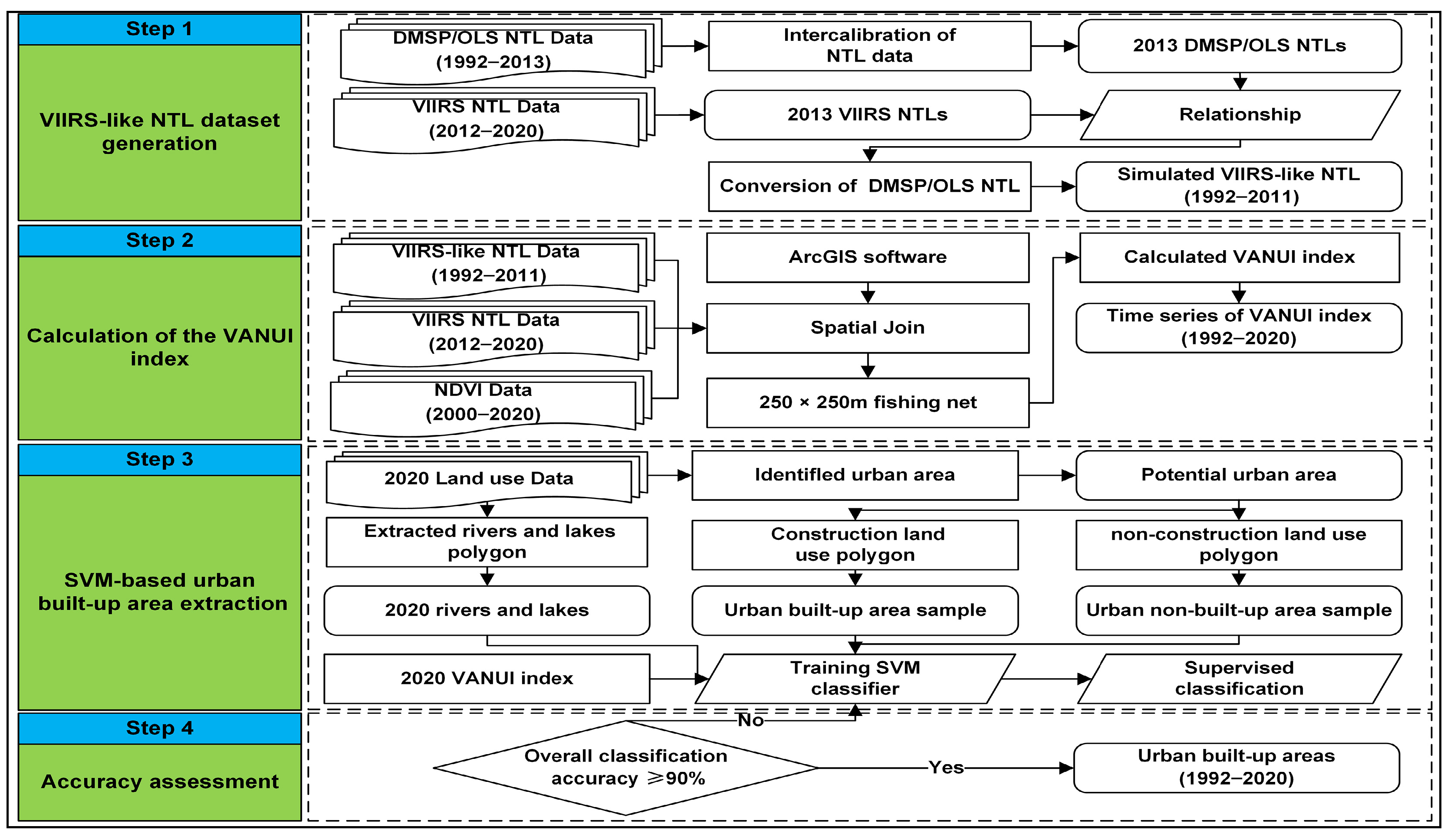
The 2020 land use data came from the Hunan Provincial Department of Natural Resources, closed for online access. The information was collected using satellite images to see things that were smaller than 1 m. These images were used to make maps, and then the maps were checked and corrected by people who went to the actual locations. We obtained the NDVI information from the Geographic Remote Sensing Ecological Network Platform (www.gisrs.cn, accessed on 1 September 2023). These data were created using the maximum NDVI method by comparing the red and near-infrared bands. The data precision is 250 m, including 21 images from 2000 to 2020.

3. Methods

This study proposes an SVM-based extraction method for distinguishing urban built-up areas in the county-level cities. The diagram in Figure 2 shows the plan for how the extraction method works. It includes the following steps: (1) VIIRS-like NTL dataset generation. (2) Calculation of the VANUI index. (3) SVM-based urban built-up-area extraction. (4) Accuracy assessment.

3.1. VIIRS-like NTL Dataset Generation

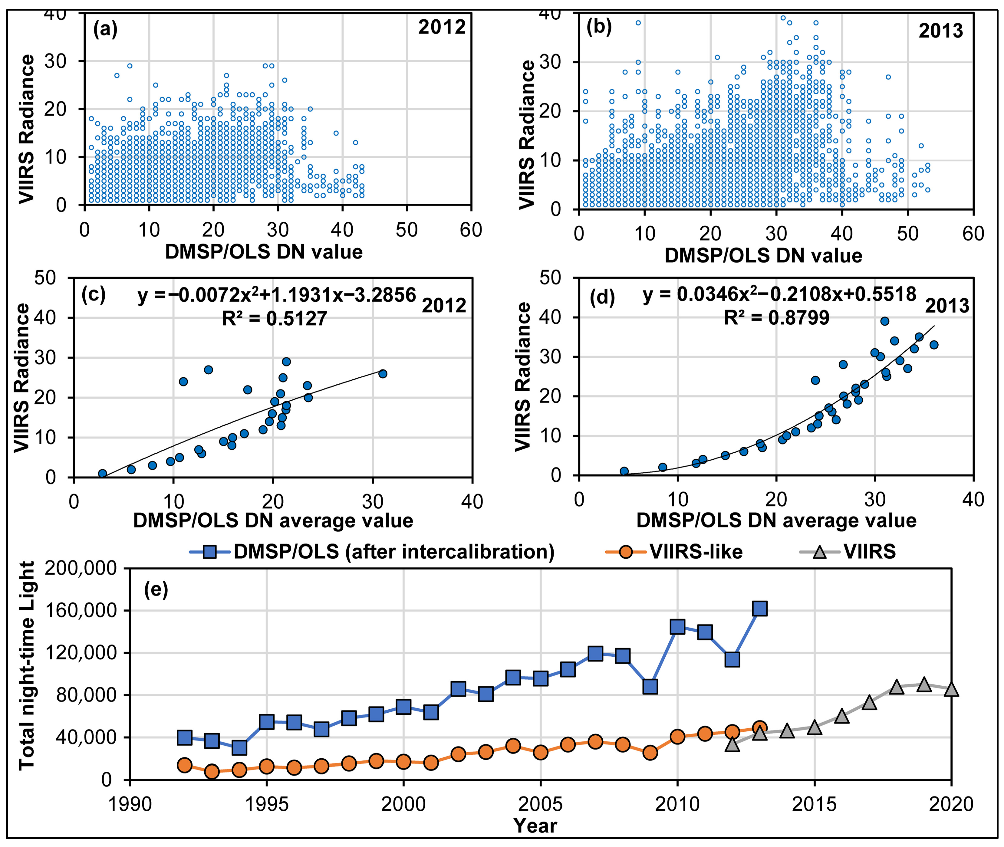
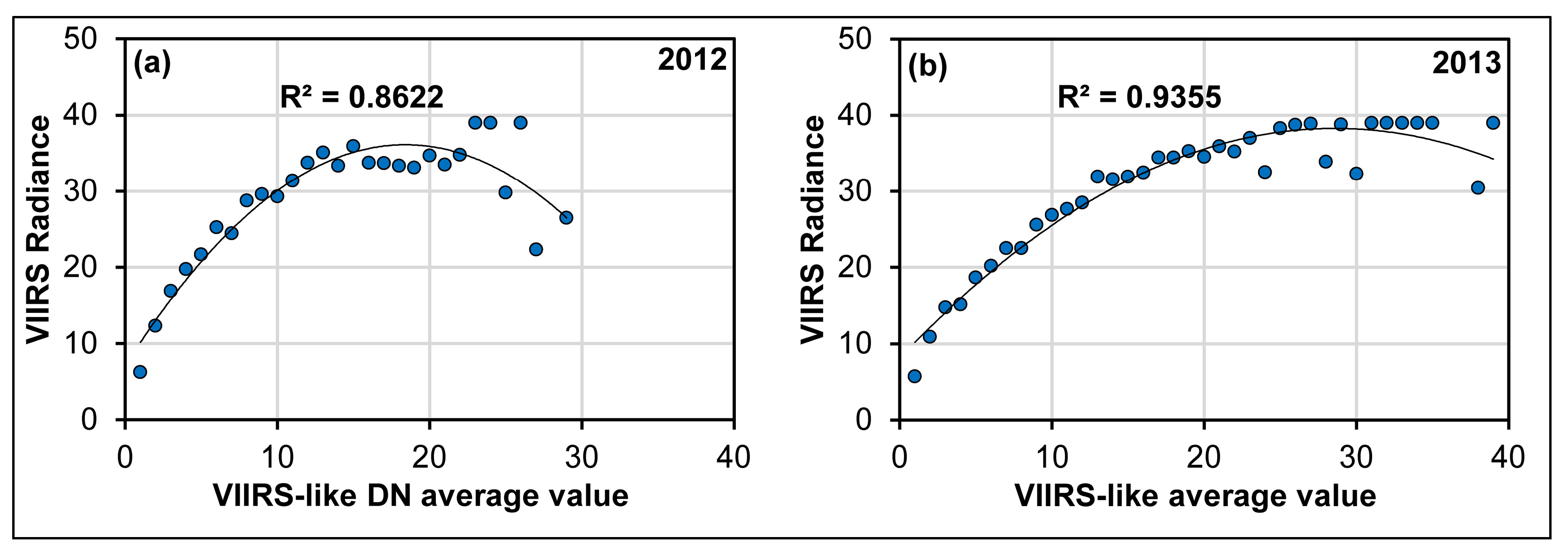
3.1.1. Intercalibration of NTL Data

Distinguishing this study from existing studies that select different assumed invariant regions for correction based on different study areas, we selected Sicily, Italy, as the target invariant region, mainly considering the applicability of our method on a global scale. Firstly, based on the interannual correction model proposed by Elvidge [22], we choose Sicily, Italy, as the target invariant region, and used the 1999 F12 satellite image as the reference image; we built a second-order polynomial function model between the reference image and the night-time light data of the other years, to calibrate the global DMSP/OLS NTL data. Table 1 details the corrected DMSP/OLS NTL interannual correction model coefficients for all the years (https://eogdata.mines.edu/dmsp/v4c_2nd_order_sicily_x1to62_y1to63.20160114.csv, accessed on 1 September 2023). Since multiple satellites have data for the same year, we combined all the data for that year and excluded pixels with significant variations from year to year. NTL data from different satellites in the same year were fixed using the method proposed by Liu [23]. The 0-value pixels in the two images were retained for intra-year fusion, and the rest were averaged from the corresponding pixels in the two images. For the background noise of the VIIRS NTL data, we took the lowest value (non-zero) of the annual Cave Lake radiation as the minimum threshold and uniformly replaced the image elements below the minimum threshold with a value of 0 to remove the background noise. Then, we used Arcmap software (version 10.2) to extract masks based on the coverage of the Dongting Lake Area to obtain NTL data.
D N C = a × D N 2 + b × D N + c
where D N is the NTL data DN original value, D N C is the NTL data DN intercalibrated value, and a , b , and c are correction model coefficients.
D N ( n , i ) = 0 ( D N n , i a + D N n , i b ) / 2 D N n , i a = 0 D N n , i b = 0 o t h e r w i s e
where D N n , i a and D N n , i b are DN values of NTL data from different satellites in the same year, D N ( n , i ) for n year value after cross-correction, and n   = 1994, 1997, 1998, …, 2007.

3.1.2. Conversion of DMSP/OLS NTL

As shown in Figure 3, due to the inconsistent resolution of DMSP/OLS and VIIRS NTL data and other differences, we examined and analyzed the scatter plots of DMSP/OLS and VIIRS NTL data in 2012 and 2013, and there was no obvious fitting relationship between the two. Based on this, we propose a fitting method based on the average DMSP/OLS DN values of the VIIRS NTL data. First, we calculated the mean DN values of the DMSP/OLS NTL data within different radiance image elements of the VIIRS NTL data. Then, we used a binary polynomial fit to understand the relationship between them. From the results, the R2 is 0.5127 in 2012 and 0.8799 in 2012, and the fit in 2013 is better than that in 2012; we use the parameters of the 2013 binary polynomial to fit the DMSP/OLS NTL data to form the VIIRS-like data from 1992 to 2011. Finally, we found that if the NTL DN value of DMSP/OLS exceeds 37, the converted value according to the parameter of the binary polynomial will exceed 40, which exceeds the highest value of the 2013 VIIRS data, so we changed the value of the converted data greater than 39 to 39, to avoid data inflation. As can be seen from the total night-time luminosity before and after conversion, the 1992–2011 VIIRS-like NTL data are better matched to the 2012–2013 VIIRS NTL data, with smoother yearly changes in total night-time light luminosity. Figure 4 shows more details of the VIIRS-like NTL compared to the original data. From the comparison, our method mitigates the bloom effect of DMSP/OLS NTL data to a certain extent, and reduces the spreading of NTL data to the periphery of urban areas. However, due to the low resolution of DMSP/OLS NTL data themselves, there is still a certain degree of bloom effect at the periphery of the city, which needs to be further processed in order to be suitable for the extraction of urban built-up areas in county-level cities.

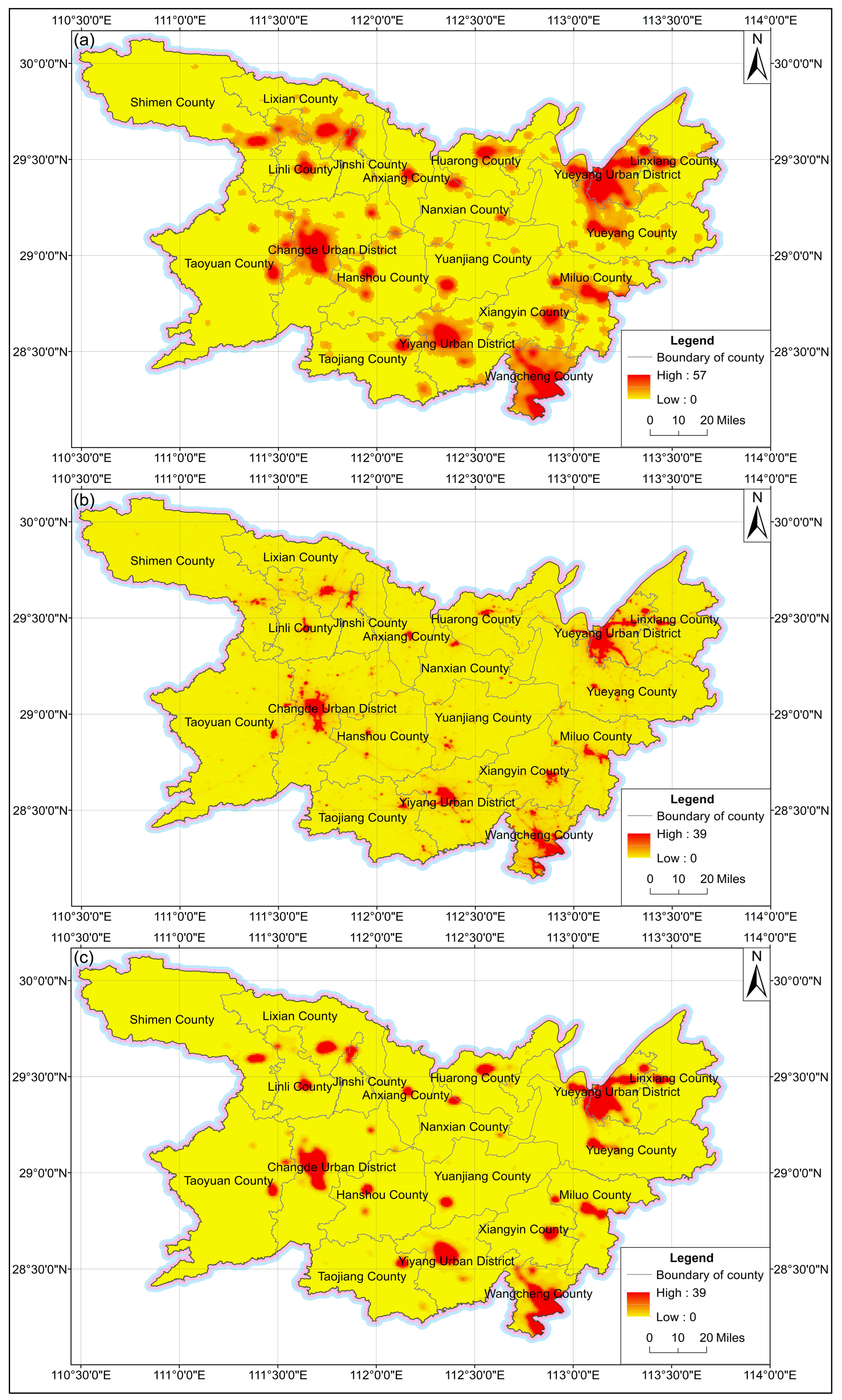
3.2. Calculation of the VANUI Index

Based on the VANUI proposed by Zhang [25], we changed the VANUI index because it was difficult to classify areas as urban or peri-urban when the NDVI was higher than 0.7. Since NDVI data with 250 m accuracy were unavailable for the years prior to 2000, the 1992–1999 NTL data were corrected using the 2000 NDVI data. Firstly, we created a 250 m × 250 m fishing net based on the extent of the Dongting Lake Area using the Create Fishnet tool of ArcMap software (version 10.2). Then, we converted the 1992–2011 VIIRS-like NTL data (resolution 30 arcseconds), the 2012–2020 VIIRS NTL data (resolution 15 arcseconds), and the 2000–2020 NDVI data (resolution 250 m) into vector raster surfaces and used the Spatial Join tool of ArcMap software (version 10.2) to connect the different data of the same year to the 250 m × 250 m fishing net, respectively; through this step, we obtained the 250 m × 250 m vector raster surface of different years from 1992 to 2020. Finally, we used the Field Calculation tool of ArcMap software (version 10.2) to calculate the VANUI index of each 250 m × 250 m patch in different years, respectively. Through the above steps, we obtained the VANUI index data with a resolution of 250 m × 250 m from 1992 to 2020.
V A N U I = 0 × N T L 1 N D V I × N T L   N D V I > 0.7 , N T L = 0   N D V I 0.7

3.3. SVM-Based Urban Built-Up-Area Extraction

As shown in Figure 4, the NTL data can better identify urban areas and large towns, but they cannot identify medium and small towns, so we limit the extraction areas to urban areas. We selected urban areas from the 2020 land use data, combined with the online e-map to delete the town and sporadic maps, and then buffered outward by 500 m to cover the potential urban areas. Since rivers run through the urban areas, coupled with the over-saturation of NTLs in urban areas and the usual NDVI < 0.7 for river and lake patches, we selected river and lake patches from the 2020 land use data as the reference patches for removing the non-built-up urban areas.
SVM is a type of classifier that separates data into two groups, using a line or plane with the most significant space between them. It is commonly used to identify urban built-up areas and non-built-up areas [50,51,52]. We use the construction selected from the 2020 land use data as the initial sample for land cover types, and non-constructed urban areas are used as the initial samples of land cover types in non-built-up areas. The classification process was carried out using ENVI software (version 5.3) with its standard settings. Divide the VANUI index data into urban built-up and non-built-up areas, perform intersection analysis between urban and potential urban areas, and exclude non-construction polygons such as water bodies to obtain the extraction results. The results of the 2020 urban built-up areas will be compared with construction in the 2020 land use data. If the difference is too significant, adjust the learning sample and repeat the above process until the overall accuracy exceeds 90%. Following the natural order for city development, the built-up areas in the previous year will be within the scope of the current year. We corrected the extraction results from 1992 to 2019, eliminating the differences in NTL data between years.

3.4. Accuracy Assessment

The confusion matrix is usually used to measure the degree of difference between the prediction results and the actual situation. Table 2 shows the detailed situation of our confusion matrix. The columns in the confusion matrix represent the classification situation, and the rows represent the actual situation. We used Overall Accuracy (OA), Commission Error (CE), Omission Error (OE), and Kappa coefficient to evaluate the accuracy of urban built-up-area extraction. OA is the fraction of pixels correctly classified compared to all the pixels. CE is the percentage of the classification results identified as urban built-up-area image elements, but they are not. OE is the proportion of the classification results that are urban built-up-area pixels but are classified as non-urban built-up-area pixels. The Kappa coefficient measures how much a classification method reduces errors compared to random guessing. It ranges from 0 to 1. If the number is higher, the classification could be reliable.

4. Results

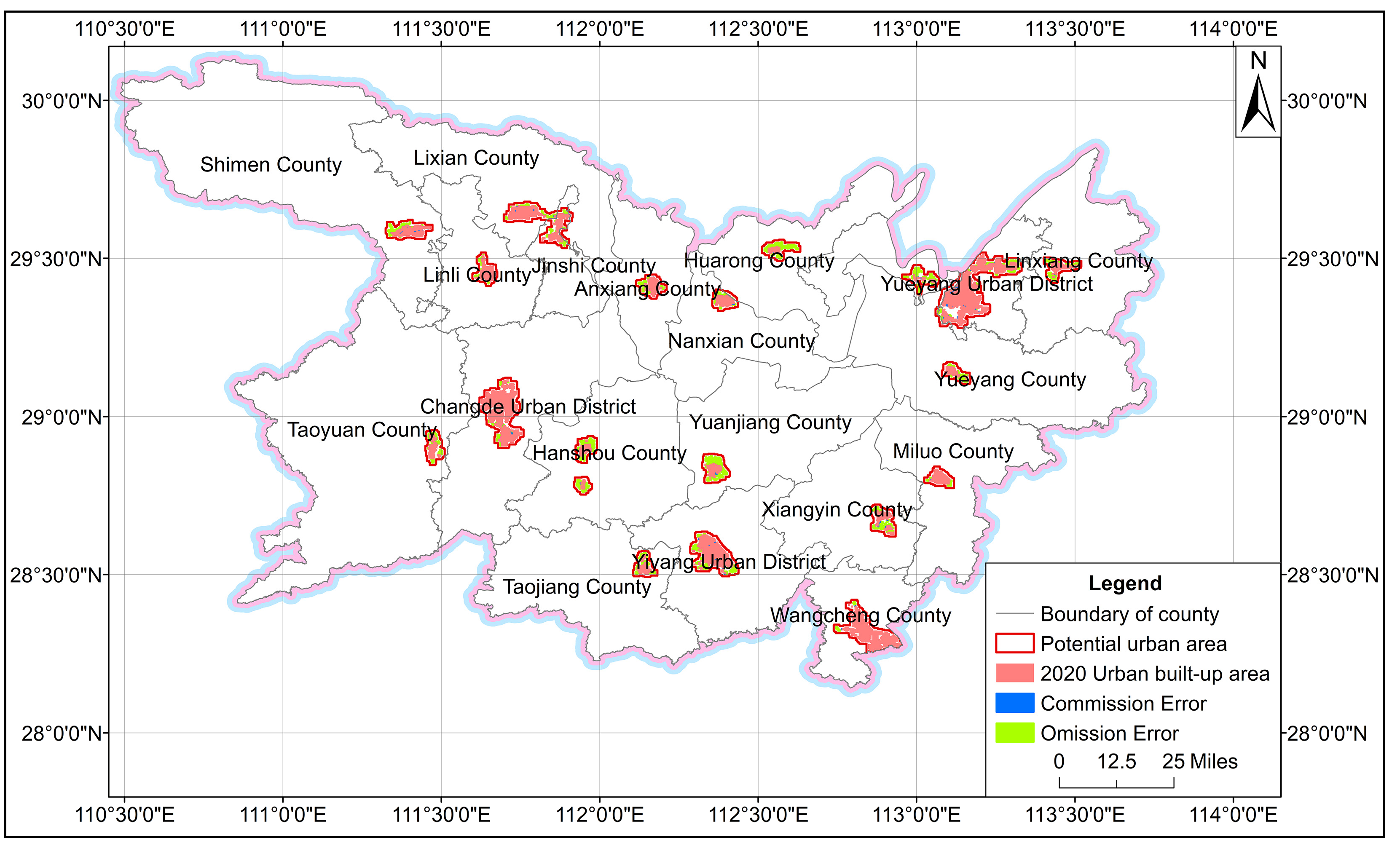
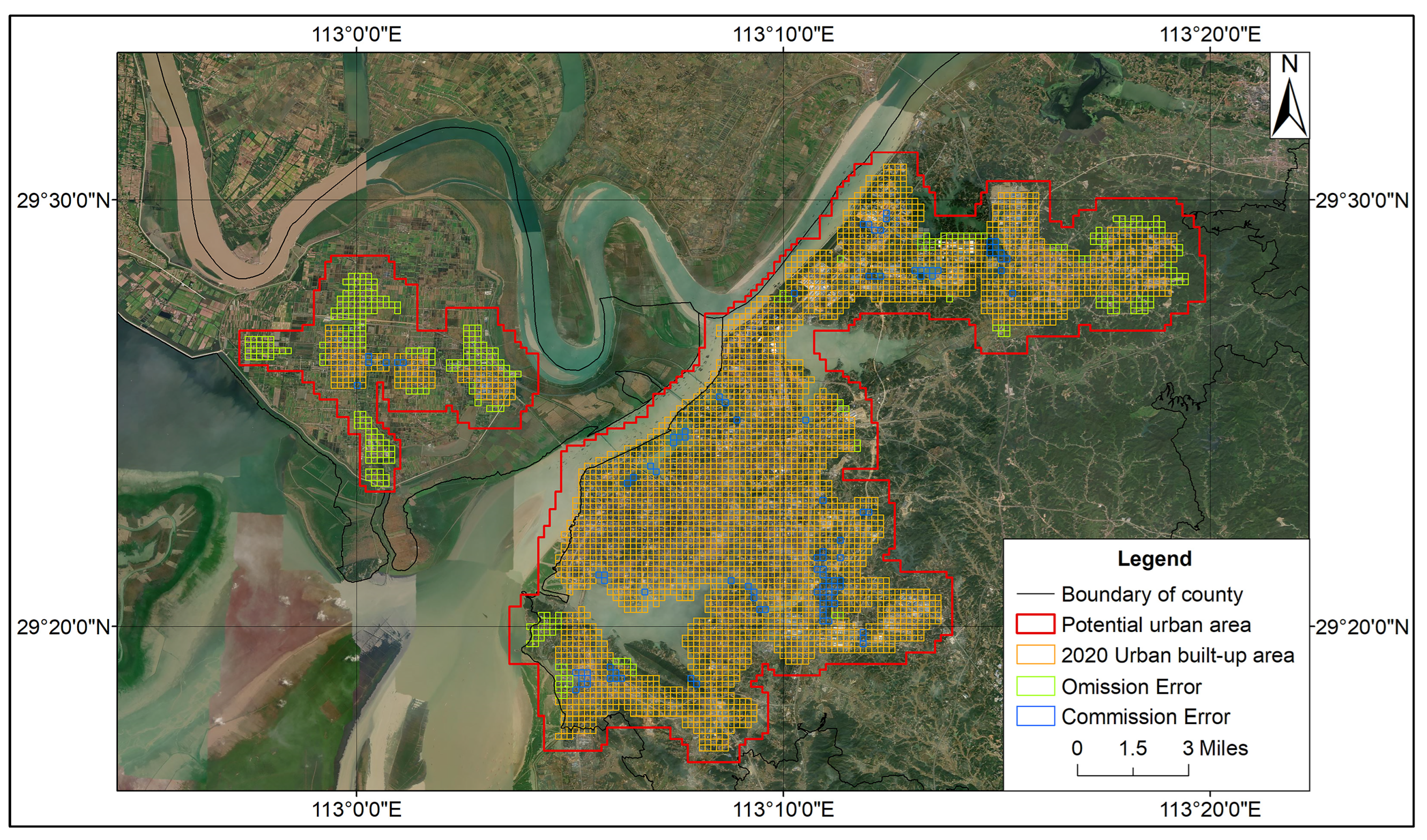
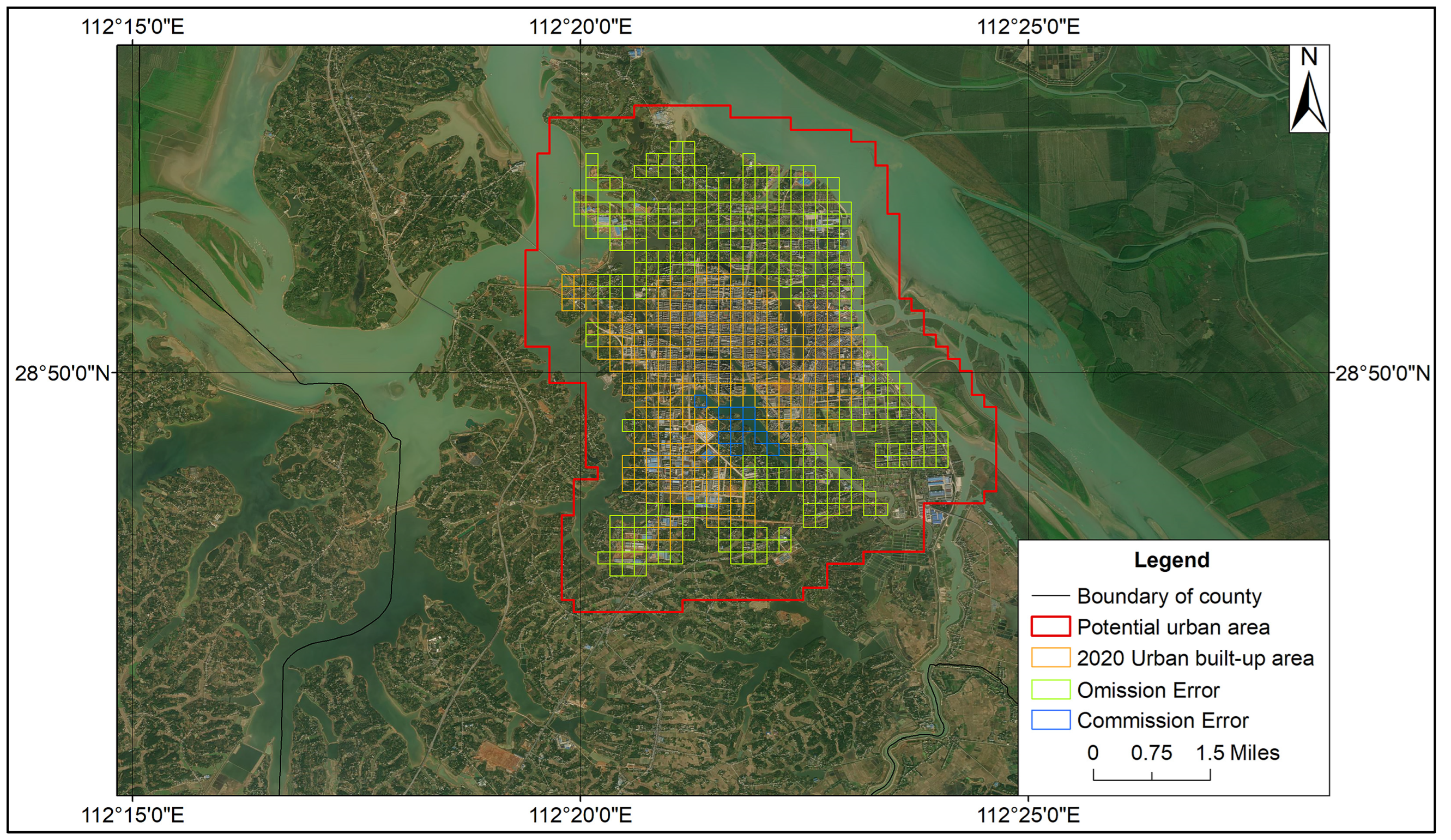
4.1. Assessment of Extraction Results

Unlike the previous extraction of random sample points for accuracy assessment, we compare 2020 extraction results with 31,291 sample points in potential urban areas to form a confusion matrix. The OA is 91.84%, the CE is 2.56%, the OE is 15.38%, and the Kappa coefficient is 0.83. Figure 5 shows the 2020 results we extracted based on the technical roadmap. The distribution pattern of urban built-up areas in 3 urban areas and 16 counties is consistent with the distribution pattern of construction land in urban areas using land in 2020. We compared our results with those of other researchers [42]. Our proposed method allows us to conveniently and accurately obtain the urban built-up areas of all county-level cities in the Dongting Lake Area. Each urban built-up area is more fine-grained than those obtained through other methods, especially in county-level cities. More details will be further explained in the Discussion section.
As shown in Figure 6, taking Yueyang Urban District as an example, the CE is mainly located in the inner-city area. Due to the diffusion effect, it is difficult to distinguish small, non-built-up areas such as natural landscapes and undeveloped areas in the inner city from the continuously built-up urban areas. As shown in Figure 7, in Yuanjiang County, the OE is within the edges of urban periphery zones, especially in the industrial areas. The NTL data cannot depict the low-density areas due to the weak intensity of the lights in the industrial areas at night. The shape of the cities that spread out from the main areas is more complicated and covers a more extensive area than the main areas shown in the NTL data. It is hard to show the scattered edges of the city. The results suggest that extraction results can characterize large continuous built-up areas well but tend to underestimate urban fringes and overestimate within cities, due to the inevitable absence of NTL data.

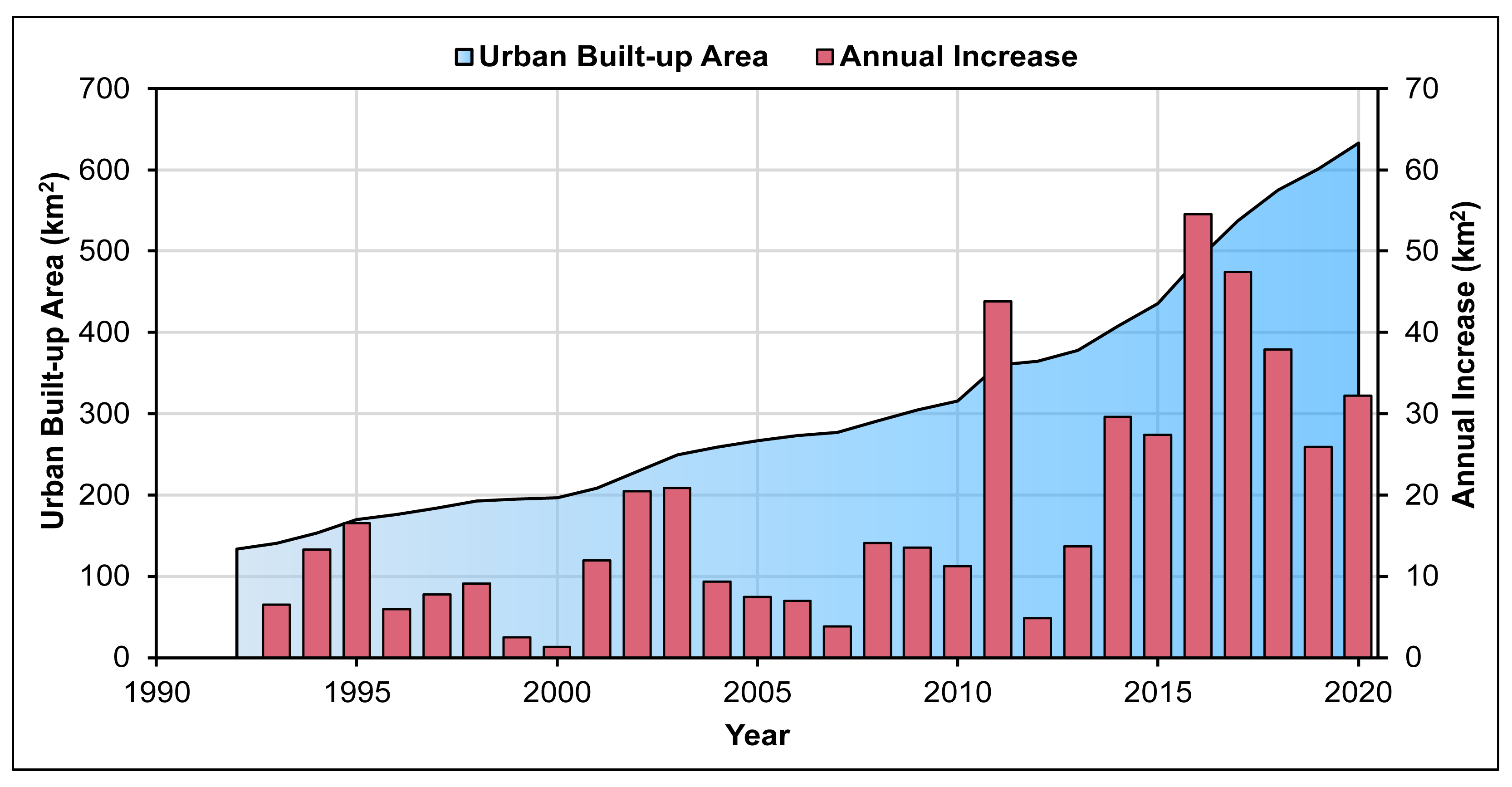
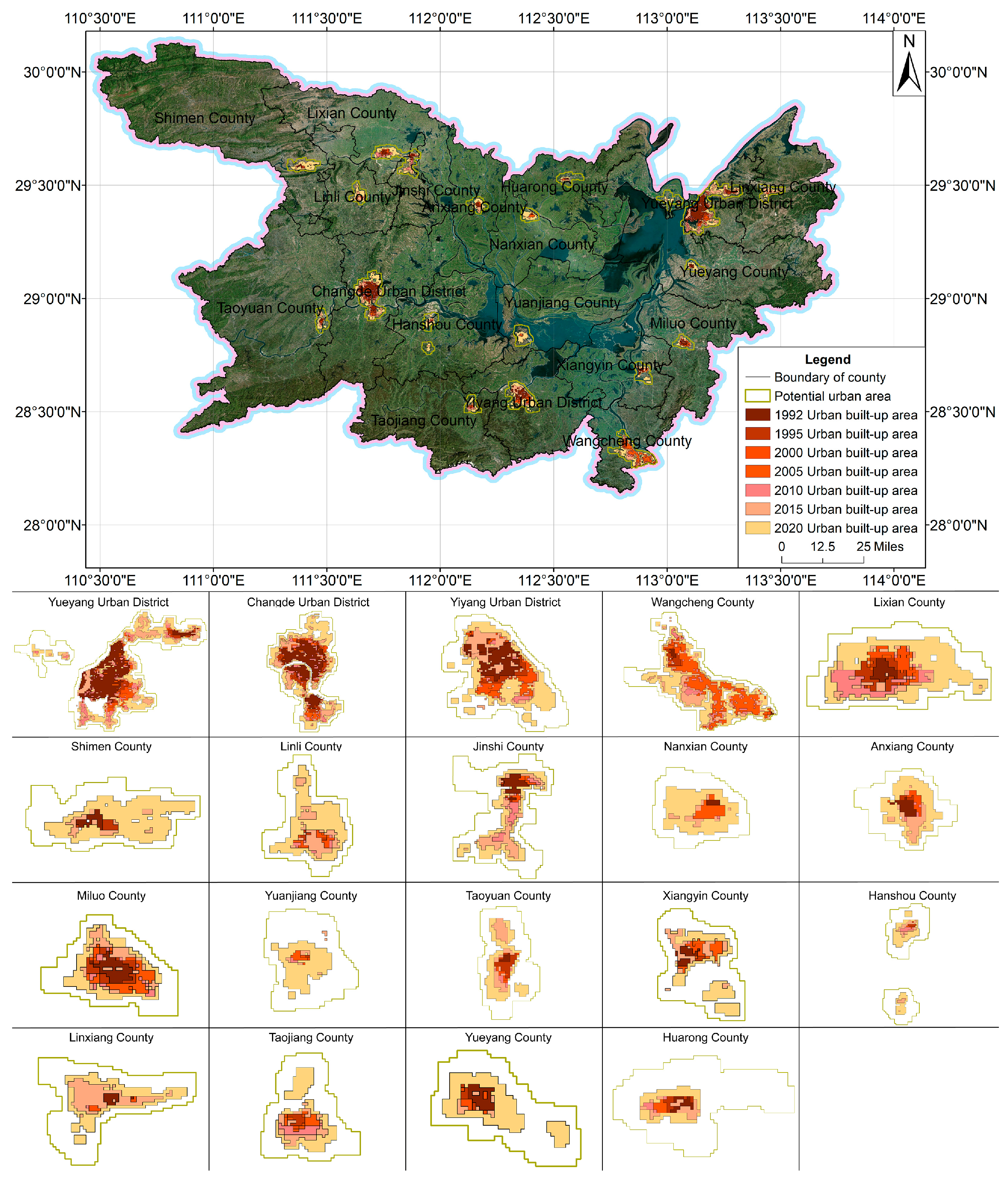
4.2. Chronological Changes
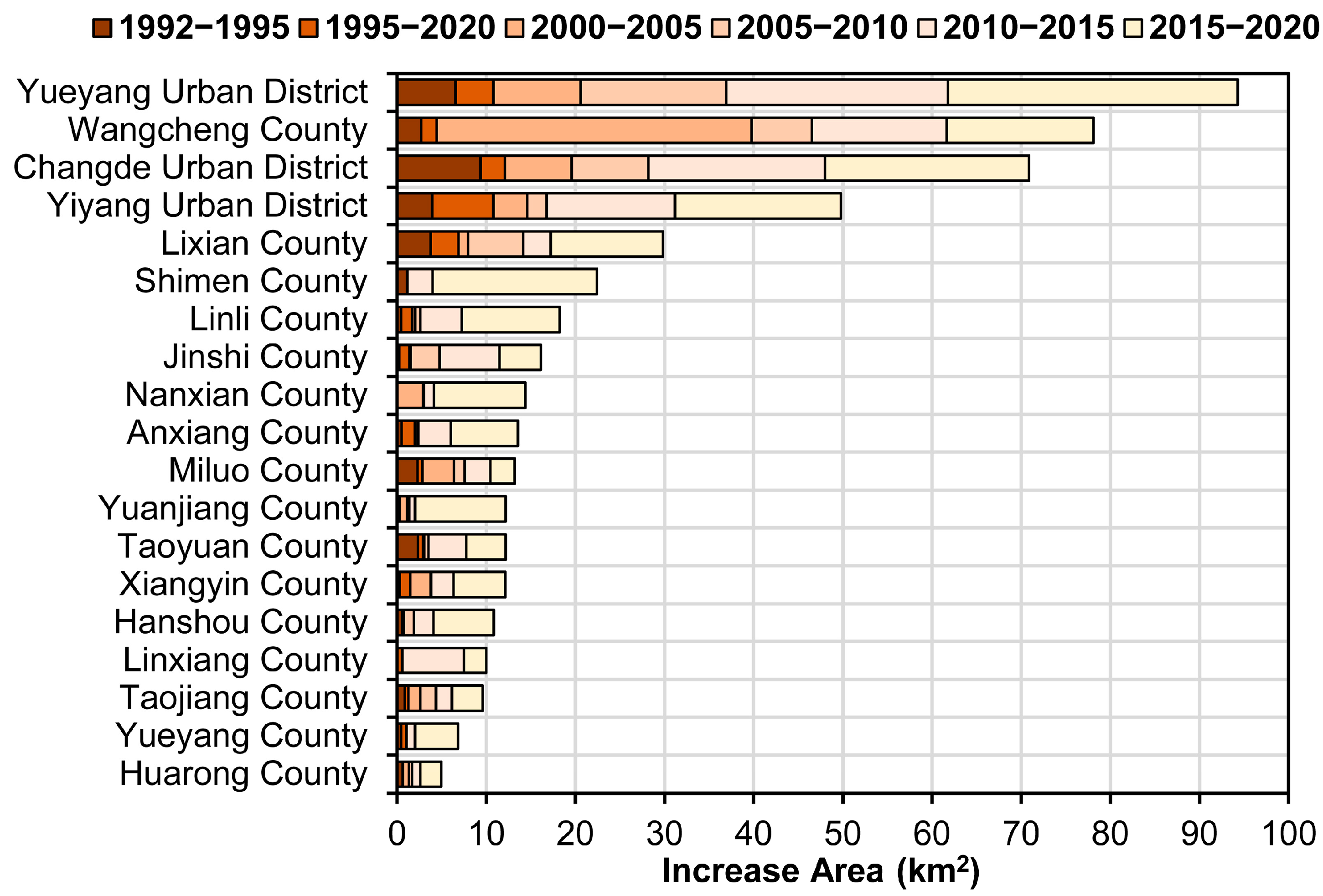
Figure 8 shows the chronological changes in total and inter-annual growth of urban built-up areas. 1992–2020, the total urban built-up areas increased from 133.93 km2 to 633.43 km2, and average annual growth was 17.84 km2; this was a remarkable urbanization process. From the point of view of average yearly growth in each stage, 2015–2020 > 2010–2015 > 2000–2005 > 2005–2010 > 1992–1995 > 1995–2000. In 1992–1995, the city expanded steadily, growing by an average of 12.07 km2 each year. In 1995–2000, affected by the 1998 mega-flood, urban construction shifted from growth to urban flood prevention and drainage and other infrastructure construction, and the average yearly growth area was reduced to 5.31 km2. In 2000–2005, during this period, the booming real estate industry drove rapid urban development, and the average yearly growth area increased to 13.99 km2. In 2005–2010, due to the impact of the Asian financial crisis, the area of built-up areas grew slowly, and the average yearly growth area reduced to 9.91 km2. In 2011–2015, the economy recovered steadily, and the city grew faster, with a yearly growth of 24.86 km2 in the built-up areas. In 015–2020, the government issued the “New Type of Urbanization Plan of Hunan Province (2015–2020)”, which scientifically guided the orderly and rapid development of cities. The cities kept growing, and more people moved to them faster, achieving a leap in urbanization, and the average yearly growth area increased to 39.59 km2.
Figure 9 shows the chronological changes in the three urban districts and sixteen counties at different stages. Regarding the three urban districts, Yueyang Urban District is significantly higher than Changde Urban District and Yiyang Urban District because Yueyang is the first batch of cities opened along the river by the State Council and is an important regional center city. Together with the advantages of natural conditions and well-developed water and land transportation, the urbanization process is faster. Concerning the 16 counties, Wangcheng County is significantly higher than the other counties. Due to its advantageous geographical location close to the capital city of Hunan Province, Changsha, Wangcheng County has achieved good economic development and added more people to live there. The government officially approved the withdrawal of Wangcheng County and its integration into the urban district of Changsha in 2011, integrating most of Wangcheng with Changsha, resulting in rapid changes in urban construction.

4.3. Spatial Change

On the one hand, due to the superior natural conditions and flat and open terrain in plain areas, the area has attracted a large number of people to concentrate here, rapidly promoting urban development, such as Yueyang Urban District, Yiyang Urban District, Changde Urban District, and Wangcheng County. On the other hand, due to the influence of topography and rivers, unique urban development patterns have been formed, such as the development of the north side of Yuanjiang County blocked by the lake, the east–west axial development of Shimen County, and the north–south axial development of Taoyuan County. Figure 10 shows the spatial changes in the three urban districts and sixteen counties, and it can be seen that the urban development has successively gone through the development phases of marginal, infill, and enclave characteristics. In 1992–2000, the growth of the city’s built-up area was dominated by peripheral expansion, which showed marginal characteristics. From 2000 to 2010, the city was dominated by peripheral expansion and internal infill, which showed typical marginal and infill characteristics. In 2010–2015, in Yueyang Urban District and Hanshou County, urban built-up area growth appeared to be interstitial development, showing the characteristics of the enclave. The river blocked the development of Yueyang Urban District, and urban built-up-area growth occurred in the north-northwest of the city. Hanshou County relies on the advantages of the highway on the south side and actively develops industrial zones, and urban built-up-area growth occurs on the city’s south side. In 2015–2020, the development of cities is mainly achieved through outward expansion, filling gaps within the city, and connecting the main urban area through roads outside the city, showing common characteristics of marginal, infill, and enclave. Due to the geographical proximity of Jinshi County and Li County, they show characteristics of urban agglomeration growth.

5. Discussion

5.1. Comparisons with Previous Studies

This study provides a convenient method to integrate DMSP/OLS and VIIRS NTL data to construct a consistent time series of NTL data (1992–2020) for the Dongting Lake Area. Compared to previous studies by scholars [34,35,36], on the one hand, our method uses the DMSP/OLS stable NTL dataset (version 4) and the VIIRS NTL dataset (version 2), both of which exclude anomalous data such as solar irradiation, glare, moonlight, aurora borealis and cloudiness. For the DMSP/OLS NTL data, we used stabilized light data that had been processed for background noise identification and replaced with zero values. For the VIIRS NTL data, we removed the background noise from the VIIRS NTL data by using the lowest (non-zero) value of the annual radiation of the Cave Lake as the minimum threshold and uniformly replacing image elements below the minimum threshold with zero. On the other hand, our method is based on the variation in DMSP/OLS and VIIRS NTL data, considering the problem of the resolution of the two types of NTL data, calculating the average DN values of the DMSP/OLS NTL data in the different irradiance image elements of the VIIRS NTL data, and using binary polynomial fitting to understand the relationship between them; the comparison based on the average value effectively alleviates the problem of inconsistency in the accuracy of the two types of NTL data. Our method is more applicable to small-scale and medium-scale county cities, avoiding the operational step of resampling the VIIRS NTL data to 1000 m × 1000 m. According to the transformed data shown in Figure 11, a high correlation exists between the class VIIRS data and VIIRS data in 2012 and 2013.
We combine NDVI, land-use and other multi-source data, use SVM classification for semi-supervised learning, and propose a high-precision extraction method applicable to built-up areas of county-level cities. Compared with previous studies by scholars, on the one hand, we use the NDVI data to generate the VANUI index and slightly improve the method, as shown in Figure 12, which can highlight the light intensity changes within the city and effectively eliminate the saturation effect of NTL in peripheral areas, and therefore provide strong support for extracting the built-up area of the city. On the other hand, since the NTL data of the Dongting Lake Area perform better in urban areas and worse in rural areas, compared with previous studies [42,53], we limit the extraction of built-up urban areas to urban areas and consider the watershed imagery and other constraints, which effectively improves the accuracy of the built-up urban-area extraction and enables us to extract the built-up urban areas of 3 urban areas and 16 counties relatively accurately. Li used Landsat and NTL images to automatically and finely extract the built-up area of the Dongting Lake Eco-Economic Zone urban agglomerations [42], and it can be seen that the method is suitable for the built-up area of the central cities in the region but not suitable for the built-up area of the county-level cities. In contrast, our proposed method can quickly and accurately obtain the urban built-up area of county-level regions, and each urban built-up area is more refined than the urban built-up area obtained by the method, especially the urban built-up area of county-level cities.

5.2. Limitations of Study

Although our integration method provides an effective way to integrate DMSP/OLS and VIIRS data for consistent monitoring of human activities, the saturation effect of DMSP data cannot be removed entirely, while the bridge crossing times of the two types of sensors, DMSP/OLS (~19:30) and VIIRS (~01:30), are different [54], which has an impact on the calibration of the data. In our study, when validating the accuracy of the research results, we only validated the accuracy of the 2020 extraction results. We extracted the urban built-up area of other years with the SVM model of 2020, mainly because the Third National Land Survey, which started in 2019, only formed the 2020 land use data. The land use data of other years have inconsistent survey standards and data resolution problems, and there are some differences with the 2020 land use data. Meanwhile, NTL data make it challenging to capture urban built-up areas that are too small, mainly due to the inherent flaws in DMSP/OLS NTL data. In our research, Hanshou County and Taojiang County could not identify urban built-up areas from 1992 to 1994, Yuanjiang County could not identify urban built-up areas from 1992 to 1993, and the northwestern part of Yueyang Urban District could not be effectively identified until 2009.

6. Conclusions

This paper proposes a high-precision extraction method suitable for extracting county-level urban built-up areas. It combines NTL, NDVI, and land use data with semi-supervised learning using SVM classification. Specifically, we base the study on analyzing and studying the characteristics of NTL data in 2012 and 2013 and the fusion and formation of VIIRS-like NTL data combined with NDVI to generate the VANUI index, thus refining the texture features of NTL data and providing a data foundation for the next step. Then, combined with the land use data, the multi-factor constraints consisting of potential urban areas, lakes, rivers, and other non-built-up areas are identified, and the SVM is used to continuously iterate the training samples and compare the results with the actual built-up area data in the land use data to achieve high-precision extraction results. Comparing results with actual urban built-up areas in land use data, the OA is 91.84%, the CE is 2.56%, the OE is 15.38%, and the Kappa coefficient is 0.83. Our proposed method can better find where cities grow in three urban districts and sixteen counties, simultaneously. The results are very reliable and new in the field of NTL data.
The spatial and temporal changes in the urban built-up area of the Dongting Lake Area are in line with reality. The region has experienced different development stages, such as stable growth, slow growth, speeding-up growth, slowing-down growth, sustained growth, and leaping growth. Yueyang Urban District is significantly higher than Changde Urban District and Yiyang Urban District; Wangcheng County in the 16 counties is significantly higher than the other counties, and the urban construction is affected by nature and rules, which makes the changes in the city complicated and happen in cycles. Urban development patterns include edge, infill, and enclave, with edge and infill predominating from 1992 to 2010, and enclave appearing in Yueyang Urban District and Hanshou County after 2010 when urban construction was affected by natural and transport conditions, and with Jinshi County and Li County showing urban agglomeration development after 2015. This research explains how urban areas have grown over time, a finding which can be used for future studies. It can give vital information to help government departments plan the growth of cities near the lake in a way that is good for the environment.
Future studies will concentrate on two main aspects: (1) making the proposed method work for other cities built on lakes, such as Poyang Lake (the largest freshwater lake in China) and Taihu Lake (the third freshwater lake in China), and in other countries. (2) Performing the proposed method using other high-precision NTL data (Loujia1−01 data, JL1-3B) to validate and make further efforts to improve the proposed method.

Author Contributions

Conceptualization, Q.D.; methodology, Y.C.; software, Y.C.; validation, F.R. and Q.D.; formal analysis, Y.C.; investigation, Y.C. and P.Z; resources, P.Z.; data curation, Y.C. and P.Z; writing—original draft preparation, Y.C.; writing—review and editing, Q.D. and F.R.; visualization, Y.C.; supervision, Q.D.; project administration, F.R.; funding acquisition, Q.D. and F.R. All authors have read and agreed to the published version of the manuscript.

Funding

This research was supported by the National Natural Science Foundation of China (Project No. 42071448).

Data Availability Statement

The raw data supporting the conclusions of this article will be made available by the authors on request.

Acknowledgments

The authors would like to thank the Earth Observation Group, Payne Institute for Public Policy, Colorado School of Mines and Geographic Remote Sensing Ecological Network Platform (www.gisrs.cn) for supporting the used data in this study.

Conflicts of Interest

The authors declare no conflicts of interest.

References

  1. Buhaug, H.; Urdal, H. An urbanization bomb? Population growth and social disorder in cities. Glob. Environ. Change-Hum. Policy Dimens. 2013, 23, 1–10. [Google Scholar] [CrossRef]
  2. Brenner, N.; Schmid, C. The ‘Urban Age’ in Question. Int. J. Urban Reg. Res. 2014, 38, 731–755. [Google Scholar] [CrossRef]
  3. Wang, X.R.; Hui, E.C.M.; Choguill, C.; Jia, S.H. The new urbanization policy in China: Which way forward? Habitat Int. 2015, 47, 279–284. [Google Scholar] [CrossRef]
  4. Chen, M.X.; Liu, W.D.; Lu, D.D. Challenges and the way forward in China’s new-type urbanization. Land Use Policy 2016, 55, 334–339. [Google Scholar] [CrossRef]
  5. Chen, M.X.; Liu, W.D.; Tao, X.L. Evolution and assessment on China’s urbanization 1960–2010: Under-urbanization or over-urbanization? Habitat Int. 2013, 38, 25–33. [Google Scholar] [CrossRef]
  6. Zhang, X.L.; Li, H. Urban resilience and urban sustainability: What we know and what do not know? Cities 2018, 72, 141–148. [Google Scholar] [CrossRef]
  7. Li, M.M.; Verburg, P.H.; van Vliet, J. Global trends and local variations in land take per person. Landsc. Urban Plan. 2022, 218, 104308. [Google Scholar] [CrossRef]
  8. Guan, X.L.; Wei, H.K.; Lu, S.S.; Dai, Q.; Su, H.J. Assessment on the urbanization strategy in China: Achievements, challenges and reflections. Habitat Int. 2018, 71, 97–109. [Google Scholar] [CrossRef]
  9. Li, C.M.; Wang, X.Y.; Wu, Z.; Dai, Z.X.; Yin, J.; Zhang, C.C. An Improved Method for Urban Built-Up Area Extraction Supported by Multi-Source Data. Sustainability 2021, 13, 5042. [Google Scholar] [CrossRef]
  10. Tian, Y.Y.; Tsendbazar, N.E.; van Leeuwen, E.; Fensholt, R.; Herold, M. A global analysis of multifaceted urbanization patterns using Earth Observation data from 1975 to 2015. Landsc. Urban Plan. 2022, 219, 104316. [Google Scholar] [CrossRef]
  11. Chen, M.X.; Ye, C.; Lu, D.D.; Sui, Y.W.; Guo, S.S. Cognition and construction of the theoretical connotations of new urbanization with Chinese characteristics. J. Geogr. Sci. 2019, 29, 1681–1698. [Google Scholar] [CrossRef]
  12. Jiang, L.W.; O‘Neill, B.C. Global urbanization projections for the Shared Socioeconomic Pathways. Glob. Environ. Change-Hum. Policy Dimens. 2017, 42, 193–199. [Google Scholar] [CrossRef]
  13. Elvidge, C.D.; Imhoff, M.L.; Baugh, K.E.; Hobson, V.R.; Nelson, I.; Safran, J.; Dietz, J.B.; Tuttle, B.T. Night-time lights of the world: 1994–1995. ISPRS J. Photogramm. Remote Sens. 2001, 56, 81–99. [Google Scholar] [CrossRef]
  14. Shi, K.F.; Huang, C.; Yu, B.L.; Yin, B.; Huang, Y.X.; Wu, J.P. Evaluation of NPP-VIIRS night-time light composite data for extracting built-up urban areas. Remote Sens. Lett. 2014, 5, 358–366. [Google Scholar] [CrossRef]
  15. Levin, N.; Kyba, C.C.M.; Zhang, Q.L.; de Miguel, A.S.; Román, M.O.; Li, X.; Portnov, B.A.; Molthan, A.L.; Jechow, A.; Miller, S.D.; et al. Remote sensing of night lights: A review and an outlook for the future. Remote Sens. Environ. 2020, 237, 111443. [Google Scholar] [CrossRef]
  16. Li, X.; Li, X.Y.; Li, D.R.; He, X.J.; Jendryke, M. A preliminary investigation of Luojia-1 night-time light imagery. Remote Sens. Lett. 2019, 10, 526–535. [Google Scholar] [CrossRef]
  17. Zheng, Q.M.; Weng, Q.H.; Huang, L.Y.; Wang, K.; Deng, J.S.; Jiang, R.W.; Ye, Z.R.; Gan, M.Y. A new source of multi-spectral high spatial resolution night-time light imagery-JL1-3B. Remote Sens. Environ. 2018, 215, 300–312. [Google Scholar] [CrossRef]
  18. Elvidge, C.D.; Baugh, K.; Zhizhin, M.; Hsu, F.C.; Ghosh, T. VIIRS night-time lights. Int. J. Remote Sens. 2017, 38, 5860–5879. [Google Scholar] [CrossRef]
  19. Zhang, Q.; Seto, K.C. Can Night-Time Light Data Identify Typologies of Urbanization? A Global Assessment of Successes and Failures. Remote Sens. 2013, 5, 3476–3494. [Google Scholar] [CrossRef]
  20. Hu, K.; Qi, K.L.; Guan, Q.F.; Wu, C.Q.; Yu, J.M.; Qing, Y.X.; Zheng, J.; Wu, H.Y.; Li, X. A Scientometric Visualization Analysis for Night-Time Light Remote Sensing Research from 1991 to 2016. Remote Sens. 2017, 9, 802. [Google Scholar] [CrossRef]
  21. Zheng, Q.M.; Seto, K.C.; Zhou, Y.Y.; You, S.X.; Weng, Q.H. Nighttime light remote sensing for urban applications: Progress, challenges, and prospects. ISPRS J. Photogramm. Remote Sens. 2023, 202, 125–141. [Google Scholar] [CrossRef]
  22. Elvidge, C.D.; Ziskin, D.; Baugh, K.E.; Tuttle, B.T.; Ghosh, T.; Pack, D.W.; Erwin, E.H.; Zhizhin, M. A Fifteen Year Record of Global Natural Gas Flaring Derived from Satellite Data. Energies 2009, 2, 595–622. [Google Scholar] [CrossRef]
  23. Liu, Z.F.; He, C.Y.; Zhang, Q.F.; Huang, Q.X.; Yang, Y. Extracting the dynamics of urban expansion in China using DMSP-OLS nighttime light data from 1992 to 2008. Landsc. Urban Plan. 2012, 106, 62–72. [Google Scholar] [CrossRef]
  24. Xin, X.; Liu, B.; Di, K.C.; Zhu, Z.; Zhao, Z.Y.; Liu, J.; Yue, Z.Y.; Zhang, G. Monitoring urban expansion using time series of night-time light data: A case study in Wuhan, China. Int. J. Remote Sens. 2017, 38, 6110–6128. [Google Scholar] [CrossRef]
  25. Zhang, Q.L.; Schaaf, C.; Seto, K.C. The Vegetation Adjusted NTL Urban Index: A new approach to reduce saturation and increase variation in nighttime luminosity. Remote Sens. Environ. 2013, 129, 32–41. [Google Scholar] [CrossRef]
  26. Zhuo, L.; Zheng, J.; Zhang, X.F.; Li, J.; Liu, L. An improved method of night-time light saturation reduction based on EVI. Int. J. Remote Sens. 2015, 36, 4114–4130. [Google Scholar] [CrossRef]
  27. Liu, Y.X.Y.; Yang, Y.P.; Jing, W.L.; Yao, L.; Yue, X.F.; Zhao, X.D. A New Urban Index for Expressing Inner-City Patterns Based on MODIS LST and EVI Regulated DMSP/OLS NTL. Remote Sens. 2017, 9, 777. [Google Scholar] [CrossRef]
  28. Zhang, J.; Yuan, X.D.; Lin, H. The Extraction of Urban Built-Up Areas by Integrating Night-Time Light and POI Data-A Case Study of Kunming, China. IEEE Access 2021, 9, 22417–22429. [Google Scholar] [CrossRef]
  29. Zhang, Q.F.; Zheng, Z.H.; Wu, Z.F.; Cao, Z.; Luo, R.B. Using Multi-Source Geospatial Information to Reduce the Saturation Problem of DMSP/OLS Nighttime Light Data. Remote Sens. 2022, 14, 3264. [Google Scholar] [CrossRef]
  30. He, X.; Zhou, C.S.; Zhang, J.; Yuan, X.D. Using Wavelet Transforms to Fuse Nighttime Light Data and POI Big Data to Extract Urban Built-Up Areas. Remote Sens. 2020, 12, 3887. [Google Scholar] [CrossRef]
  31. He, X.; Zhang, Z.M.; Yang, Z.J. Extraction of urban built-up area based on the fusion of night-time light data and point of interest data. R. Soc. Open Sci. 2021, 8, 210838. [Google Scholar] [CrossRef] [PubMed]
  32. Li, X.M.; Song, Y.S.; Liu, H.; Hou, X.Y. Extraction of Urban Built-Up Areas Using Nighttime Light (NTL) and Multi-Source Data: A Case Study in Dalian City, China. Land 2023, 12, 495. [Google Scholar] [CrossRef]
  33. Li, X.; Li, D.R.; Xu, H.M.; Wu, C.Q. Intercalibration between DMSP/OLS and VIIRS night-time light images to evaluate city light dynamics of Syria’s major human settlement during Syrian Civil War. Int. J. Remote Sens. 2017, 38, 5934–5951. [Google Scholar] [CrossRef]
  34. Li, X.C.; Zhou, Y.Y.; Zhao, M.; Zhao, X. A harmonized global nighttime light dataset 1992–2018. Sci. Data 2020, 7, 168. [Google Scholar] [CrossRef] [PubMed]
  35. Zhao, M.; Zhou, Y.Y.; Li, X.C.; Zhou, C.H.; Cheng, W.M.; Li, M.C.; Huang, K. Building a Series of Consistent Night-Time Light Data (1992–2018) in Southeast Asia by Integrating DMSP-OLS and NPP-VIIRS. IEEE Trans. Geosci. Remote Sens. 2020, 58, 1843–1856. [Google Scholar] [CrossRef]
  36. Chen, Z.Q.; Yu, B.L.; Yang, C.S.; Zhou, Y.Y.; Yao, S.J.; Qian, X.J.; Wang, C.X.; Wu, B.; Wu, J.P. An extended time series (2000–2018) of global NPP-VIIRS-like nighttime light data from a cross-sensor calibration. Earth Syst. Sci. Data 2021, 13, 889–906. [Google Scholar] [CrossRef]
  37. Zhou, Y.Y.; Smith, S.J.; Elvidge, C.D.; Zhao, K.G.; Thomson, A.; Imhoff, M. A cluster-based method to map urban area from DMSP/OLS nightlights. Remote Sens. Environ. 2014, 147, 173–185. [Google Scholar] [CrossRef]
  38. Ma, T.; Zhou, Y.K.; Zhou, C.H.; Haynie, S.; Pei, T.; Xu, T. Night-time light derived estimation of spatio-temporal characteristics of urbanization dynamics using DMSP/OLS satellite data. Remote Sens. Environ. 2015, 158, 453–464. [Google Scholar] [CrossRef]
  39. Liu, L.; Leung, Y. A study of urban expansion of prefectural-level cities in South China using night-time light images. Int. J. Remote Sens. 2015, 36, 5557–5575. [Google Scholar] [CrossRef]
  40. Pandey, B.; Joshi, P.K.; Seto, K.C. Monitoring urbanization dynamics in India using DMSP/OLS night time lights and SPOT-VGT data. Int. J. Appl. Earth Obs. Geoinf. 2013, 23, 49–61. [Google Scholar] [CrossRef]
  41. Ju, Y.; Dronova, I.; Ma, Q.; Zhang, X. Analysis of urbanization dynamics in mainland China using pixel-based night-time light trajectories from 1992 to 2013. Int. J. Remote Sens. 2017, 38, 6047–6072. [Google Scholar] [CrossRef]
  42. Li, Q.M.; Zheng, B.H.; Tu, B.; Yang, Y.S.; Wang, Z.Y.; Jiang, W.; Yao, K.; Yang, J.W. Refining Urban Built-Up Area via Multi-Source Data Fusion for the Analysis of Dongting Lake Eco-Economic Zone Spatiotemporal Expansion. Remote Sens. 2020, 12, 1797. [Google Scholar] [CrossRef]
  43. Zhou, Y.Y.; Li, X.C.; Asrar, G.R.; Smith, S.J.; Imhoff, M. A global record of annual urban dynamics (1992–2013) from nighttime lights. Remote Sens. Environ. 2018, 219, 206–220. [Google Scholar] [CrossRef]
  44. Kamarajugedda, S.A.; Mandapaka, P.V.; Lo, E.Y.M. Assessing urban growth dynamics of major Southeast Asian cities using night-time light data. Int. J. Remote Sens. 2017, 38, 6073–6093. [Google Scholar] [CrossRef]
  45. Zhong, Y.; Lin, A.W.; Zhou, Z.G.; Chen, F.Y. Spatial Pattern Evolution and Optimization of Urban System in the Yangtze River Economic Belt, China, Based on DMSP-OLS Night Light Data. Sustainability 2018, 10, 3782. [Google Scholar] [CrossRef]
  46. Xu, T.; Ma, T.; Zhou, C.H.; Zhou, Y.K. Characterizing Spatio-Temporal Dynamics of Urbanization in China Using Time Series of DMSP/OLS Night Light Data. Remote Sens. 2014, 6, 7708–7731. [Google Scholar] [CrossRef]
  47. Elvidge, C.D.; Baugh, K.E.; Kihn, E.A.; Kroehl, H.W.; Davis, E.R. Mapping city lights with nighttime data from the DMSP operational linescan system. Photogramm. Eng. Remote Sens. 1997, 63, 727–734. [Google Scholar]
  48. Baugh, K.; Elvidge, C.D.; Ghosh, T.; Ziskin, D. Development of a 2009 stable lights product using DMSP-OLS data. Proc. Asia-Pac. Adv. Netw. 2010, 30, 114. [Google Scholar] [CrossRef]
  49. Elvidge, C.D.; Zhizhin, M.; Ghosh, T.; Hsu, F.C.; Taneja, J. Annual Time Series of Global VIIRS Nighttime Lights Derived from Monthly Averages: 2012 to 2019. Remote Sens. 2021, 13, 922. [Google Scholar] [CrossRef]
  50. Ma, X.L.; Tong, X.H.; Liu, S.C.; Luo, X.; Xie, H.; Li, C.M. Optimized Sample Selection in SVM Classification by Combining with DMSP-OLS, Landsat NDVI and GlobeLand30 Products for Extracting Urban Built-Up Areas. Remote Sens. 2017, 9, 236. [Google Scholar] [CrossRef]
  51. Ma, X.L.; Li, C.M.; Tong, X.H.; Liu, S.C. A New Fusion Approach for Extracting Urban Built-up Areas from Multisource Remotely Sensed Data. Remote Sens. 2019, 11, 2516. [Google Scholar] [CrossRef]
  52. Liu, L.; Li, Z.C.; Fu, X.Y.; Liu, X.; Li, Z.H.; Zheng, W.F. Impact of Power on Uneven Development: Evaluating Built-Up Area Changes in Chengdu Based on NPP-VIIRS Images (2015–2019). Land 2022, 11, 489. [Google Scholar] [CrossRef]
  53. Chai, C.; He, Y.; Yu, P.; Zheng, Y.; Chen, Z.; Fan, M.; Lin, Y.J.L. Spatiotemporal evolution characteristics of urbanization in the xiamen special economic zone based on nighttime-light data from 1992 to 2020. Land 2022, 11, 1264. [Google Scholar] [CrossRef]
  54. Elvidge, C.D.; Baugh, K.E.; Zhizhin, M.; Hsu, F.C. Why VIIRS data are superior to DMSP for mapping nighttime lights. Proc. Asia-Pac. Adv. Netw. 2013, 35. [Google Scholar] [CrossRef]
Figure 1. (a) Map of study area in China, (b) detailed map of study area.
Land 13 01006 g001
Figure 2. The integrated methodological framework.
Land 13 01006 g002
Figure 3. (a) Scatter map of NTLs in 2012, (b) scatter map of district NTLs in 2013, (c) scatter plot graph of district NTLs in 2012, (d) scatter plot graph of district NTLs in 2013, (e) trends in total NTL change from 1992 to 2020.
Land 13 01006 g003
Figure 4. (a) DMSP/OSL NTL data in 2013, (b) VIIRS NTL data in 2013, (c) VIIRS-like NTL data in 2013.
Land 13 01006 g004
Figure 5. Extraction results in 2020.
Land 13 01006 g005
Figure 6. Comparison of extraction results and remote-sensing images in Yueyang Urban District.
Land 13 01006 g006
Figure 7. Comparison of extraction results and remote-sensing images in Yuanjiang County.
Land 13 01006 g007
Figure 8. Total urban built-up areas and annual increase from 1992 to 2020.
Land 13 01006 g008
Figure 9. Phased increase in three urban districts and sixteen counties.
Land 13 01006 g009
Figure 10. Spatial changes in three urban districts and sixteen counties.
Land 13 01006 g010
Figure 11. (a) Satter plot graph of district NTLs in 2012, (b) scatter plot graph of district NTLs in 2013.
Land 13 01006 g011
Figure 12. VANUI NTL data in 2020.
Land 13 01006 g012
Table 1. Interannual correction model coefficients.
SatelliteYearabcR2SatelliteYearabcR2
F101992−2.0570 1.5903 −0.0090 0.9075 F1520020.0491 0.9568 0.0010 0.9658
F101993−1.0582 1.5983 −0.0093 0.9360 F1520030.2217 1.5122 −0.0080 0.9314
F101994−0.3458 1.4864 −0.0079 0.9243 F1520040.5751 1.3335 −0.0051 0.9479
F121994−0.6890 1.1770 −0.0025 0.9071 F1520050.6367 1.2838 −0.0041 0.9335
F121995−0.0515 1.2293 −0.0038 0.9178 F1520060.8261 1.2790 −0.0041 0.9387
F121996−0.0959 1.2727 −0.0040 0.9319 F1520071.3606 1.2974 −0.0045 0.9013
F121997−0.3321 1.1782 −0.0026 0.9245 F1620040.2853 1.1955 −0.0034 0.9039
F121998−0.0608 1.0648 −0.0013 0.9536 F162005−0.0001 1.4159 −0.0063 0.9390
F1219990.0000 1.0000 0.0000 1.0000 F1620060.1065 1.1371 −0.0016 0.9199
F141997−1.1323 1.7696 −0.0122 0.9101 F1620070.6394 0.9114 0.0014 0.9511
F141998−0.1917 1.6321 −0.0101 0.9723 F1620080.5564 0.9931 0.0000 0.9450
F141999−0.1557 1.5055 −0.0078 0.9717 F1620090.9492 1.0683 −0.0016 0.8918
F1420001.0988 1.3155 −0.0053 0.9278 F1820102.3430 0.5102 0.0065 0.8462
F1420010.1943 1.3219 −0.0051 0.9448 F1820102.3458 0.5100 0.0065 0.8453
F1420021.0517 1.1905 −0.0036 0.9203 F1820111.8956 0.7345 0.0030 0.9095
F1420030.7390 1.2416 −0.0040 0.9432 F1820121.8750 0.6203 0.0052 0.9392
F1520000.1254 1.0452 −0.0010 0.9320 F1820131.8411 0.7049 0.0033 0.9321
F152001−0.7024 1.1081 −0.0012 0.9593
Table 2. Confusion matrix.
ClassActual Class
Built-Up AreaNon-Built-Up Area
Predicted classBuilt-up AreaTrue Built-up AreaFalse Built-up Area
Non-built-up
Area
False Non-Built-up Area True Non-Built-up Area
Disclaimer/Publisher’s Note: The statements, opinions and data contained in all publications are solely those of the individual author(s) and contributor(s) and not of MDPI and/or the editor(s). MDPI and/or the editor(s) disclaim responsibility for any injury to people or property resulting from any ideas, methods, instructions or products referred to in the content.

