Abstract
Rural communities in ecologically sensitive areas are confronted with environmental challenges and land waste. The hollowing out of villages because of the steady loss of young people has brought these problems to the fore. Research on the remediation of rural settlements in ecologically sensitive regions is scarce. This paper focuses on Tong Yu County, a region located in the agricultural and pastoral intertwined zones of western Jilin, which is known for its ecological sensitivity. On the basis of the results of the geographical assessment of the area via hierarchical analysis (AHP method) and soil and water conservation capacity evaluation via the revised universal soil loss equation model (RUSLE) and the net primary production quantitative index model (NPP model), we propose a rural development program that divides the study area into three different zones with different development orientations, namely, potential enhancement, agglomeration development, and expansion restrictions. Moreover, we conceived a rural settlement remediation scheme using the kernel density estimation method and provided remediation strategies for rural settlements of various density levels. The rural settlement development program and the rural settlement remediation scheme led to the optimization of rural settlements. Notably, with increasing kernel density, the area of rural settlements tends to increase and then decrease. Our research helps save 5.059 km2 of land resources in the study area and offers guidance for improving the rural settlement layout in Tong Yu County.
1. Introduction
Rural settlements contain commercial, service, residential, industrial, school, and other lands located in the countryside and facilitate the production and life of rural residents. They represent the core of human–land relations in rural areas [1]. With the growth of global industrialization and urbanization, rural populations continue to migrate to cities, and the hollowing out of the countryside has become an issue of concern for scholars worldwide, especially for developing countries [2]. Scholars from India, Indonesia, Vietnam and Iran have focused on problems such as the unequal availability of infrastructure for rural dwellers and the threat of urban sprawl onto arable land and the rural natural environment. There are some evident signs of the extinction of traditional handicraft villages. While urbanization allows for villagers to enjoy better health care, communication services, and housing security, it also increases the tax burden, shrinks agricultural land, and destroys the natural environment [3,4,5,6]. With the implementation of China’s reform and opening-up policy, urbanization has intensified. The hollowing out of the countryside has intensified, and the problems of the uncontrolled expansion and idleness of rural settlements have occurred simultaneously [7]. The problem of urban sprawl, represented by unused rural settlements, has attracted the attention of all sectors of society [8]. In the mid-1990s, the Chinese government initiated a pilot land consolidation program in some areas to conserve land resources by merging rural settlements with large-scale centralized settlements, which was developed into a national policy in 2008 [9]. After nearly 30 years of land consolidation, some of the pilot regions have improved the efficiency of public services, reduced land waste, and improved living and housing conditions [10]. On the other hand, the spatial distribution of rural settlements varies significantly across different regions and is influenced by factors such as location, elevation, and precipitation. At present, however, the majority of rural land remediation programs involve the complete relocation of rural settlements, and remediation programs tailored to the characteristics of a specific region are lacking [11].
The arrangement of rural settlements is shaped by integrated natural, economic, and social factors [10]. Previous research has identified the spatial and temporal distributions of rural settlements and the factors that influence them, as well as rural settlement evaluation, simulation of rural settlement evolution, and other perspectives focused on the needs of farmers from various aspects, such as production, life, and ecology [11,12,13,14,15,16]. Yang Ren and her team studied the types of spatial distributions of rural settlements in different regions of China and concluded that there are significant regional differences in the spatial distributions of rural settlements, with elevation and slope being the key factors constraining the layout of rural settlements [15]. Results from Li and his coworkers revealed an apparent symbiotic relationship between rural settlements and cultivated land, which was closely related to the degree of ecological stability of the area [13,16]. The distribution of rural settlements in China is dense in the east and sparse in the west according to related studies. In addition, the expansion of rural settlements has a greater impact on arable land than the occupation of land by urban expansion does, and expansion tends to occur in areas with low elevation and good transportation conditions [14]. Research indicates that the expansion of rural settlements is closely related to the economic and policy environment [17]. To develop more effective policies, more scientific means of identifying rural settlements are needed. A study of rural settlement segmentation based on deep learning can provide an explicit image for identifying rural settlement evolution in Zagora Province, Draa-Tafilalet region, Morocco [18]. By recognizing images of rural settlements, studies have revealed that the uncontrolled expansion of rural settlements in recent years has exacerbated landscape fragmentation, which has threatened ecological stability in ecologically sensitive areas [19,20,21]. To protect farmers in settlement areas from the threat of an unstable ecological environment, many studies have been dedicated to examining rural settlements located in ecologically sensitive regions, involving areas such as the Loess Plateau, the Tibetan Plateau, the northern agricultural and pastoral intertwined areas, the Wuling Mountains in southeastern Chongqing, the southwestern mountains, northwestern highlands of Ethiopia, and the Merkez, Tercan, Kemaliye, and Kemah districts in Turkey, Erzincan Province [21,22,23,24,25]. On the one hand, studies have shown that rural residents in ecologically fragile areas are highly vulnerable to the impacts of environmental change [26]. On the other hand, studies from other countries, such as Ethiopia, have conducted surveys by sending questionnaires to farmers, demonstrating that the active participation of farmers in soil and water conservation has led to the success of water and soil conservation approaches [27]. A study from Turkey suggested creating an eco-village in ecologically sensitive areas to ensure the stability of farmer settlements [28].
Soil erosion is one of the most important factors destabilizing the ecological environment, specifically in terms of nutrient loss, soil compaction, soil fertility and water quality reduction in cultivated areas, species habitat shrinkage, and a decrease in ecosystem services, which in turn leads to a decline in crop yields and threatens farmer incomes. Previous studies have shown that rural settlements have a symbiotic relationship with cropland and that regional soil and water conservation capacity is significant for rural settlements [29,30,31,32]. Regions with severe soil and water erosion often face poverty problems [33,34].
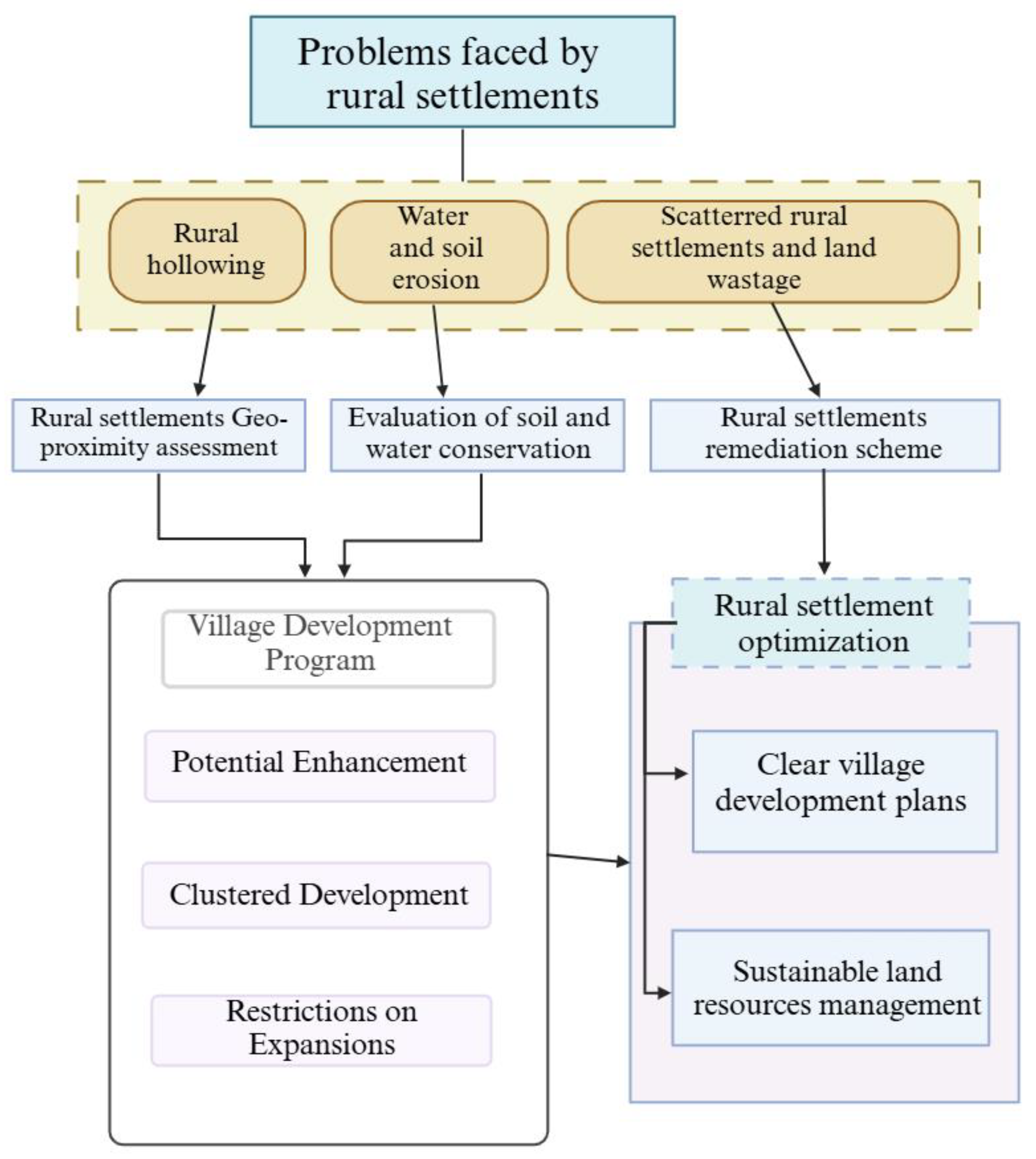
On the basis of the results of previous research, to solve the problems of scattered settlements such as land waste, which is common in rural settlements in ecologically sensitive areas, and to protect the livelihoods of farmers in such areas from the threat of soil erosion, this paper integrated the evaluation of the geographical proximity assessment of rural settlements with the evaluation of soil and water conservation capacity to form a rural development program and conceived a rural settlement remediation scheme via kernel density estimation (Figure 1). We used Tong Yu County, a typical ecologically sensitive area in the western part of Jilin Province, as the study area. This research explored a remediation program that can ensure that the living environment of farmers does not undergo any drastic changes. Therefore, we fully considered differences in the water and soil conservation capacity of ecologically sensitive areas, the high fragmentation of rural settlements, and the serious waste of land. We propose a rural settlement remediation scheme and a rural development program. Our study provides a basis for decision-making concerning the rational remediation of settlements in ecologically fragile areas.

Figure 1.
Framework of the optimization of rural settlements.
2. Materials and Methods
2.1. Study Area
Tong Yu County, Jilin Province, is located on the eastern border of the Horqin Grassland in the western part of Jilin Province, China (120°02′~123°30′ E, 44°12′~45°16′ N) (Figure 2). The county has a flat topography, with an elevation of 49 m to 232 m above sea level. The 30-year average annual precipitation of the county is 364.1 mm (1991–2020), and the distribution of precipitation within the year is uneven and fluctuates dramatically, with frequent droughts and floods [35]. The soil matrix of Tong Yu County consists of Quaternary river and lake deposits and river alluvial deposits. Soil types such as Humic Cambisols, Gelic Gleysols, Eutric Regosols, Haplic Solonetz, and Rock Outcrops have been developed. According to the outcome of the Third Land Survey in China, the land-use structure of Tong Yu County is 10.24% grassland, 53.07% arable land, and 13.74% saline and alkaline land. Related research has shown that the soil erosion rate is 54.47%, which is significantly higher than the provincial average level [36]. The long-term irrational land-use structure and climatic conditions have gradually increased the risk of soil erosion in Tong Yu County, manifested in sandy and saline grasslands, the degradation of marshes into hay meadows, the shrinkage of wetlands, and the decline in soil fertility.
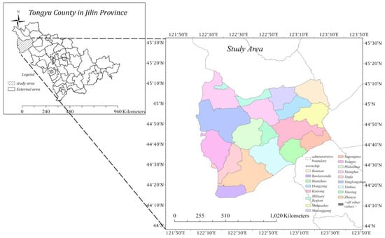
Figure 2.
Geographical location of Tong Yu County.
Tong Yu County has 16 townships and 172 administrative villages, with a total area of 8476.39 square kilometers and a total population of 350,400. Of these, 236,955 are in rural areas, accounting for 67.2% of the total population, and 22% are over 60 years old, whereas 95.93% of all the villages show a trend of “hollowing out” [37].
2.2. Data Sources
The data on land use and administrative boundaries were derived from the results of the Third Land Survey and the Wuhan University CLCD [38]. The soil data were from the World Food Organization [39]. The NPP data were obtained from NASA [40]. The rainfall data were obtained from China’s 1 km resolution monthly precipitation dataset (1901–2022) by Shou Zhang Peng of the Tibetan Plateau Science Data Center [35]. The elevation data were obtained from the geospatial data cloud.
2.3. Rural Geographical Assessment
On the basis of the different impacts of different geographical elements (rivers, roads, and arable land) on the evolution of rural settlements, we utilized the distance of these geographical elements from rural settlements as an indicator and used hierarchical analysis (AHP) to assign weights to the indicator, i.e., . For the same indicator, the proximity of the distance (buffer) has a different impact on the evolution of rural settlements. Therefore, we assigned values xj to different buffer zones. We obtained the equation for the proximity analysis of rural settlements on the basis of geographic proximity (Equation (1)), where represents the specific geographical proximity score of each rural settlement.
To obtain the rural geographical assessment scores of administrative villages in Tong Yu County, the geographical proximity scores of rural settlement patches were averaged statistically on a village-by-village basis (Equation (2)), where is the total number of rural settlement patches in administrative villages and Tong Yu County has 178 administrative villages, represent the level of village location.
2.4. Evaluation of Soil and Water Conservation for Tong Yu County
Previous research has shown that soil erosion is one of the main threats to farmer livelihoods in ecologically fragile areas, such as Tong Yu County. Moreover, water conservation and soil retention services are also important components of ecosystem services [16,32,41,42]. The revised universal soil loss equation (RUSLE), which is a quantitative estimation model for soil erosion widely used worldwide, was proposed by the U.S. Department of Agriculture (USDA), and the INVEST model, which not only measures soil erosion but also considers the role of surface vegetation in sand retention, improves the RUSLE model. It is more accurate and reasonable than the RUSLE model [43,44]. Furthermore, the evaluation of the water conservation function adopts the NPP quantitative assessment method, which measures the level of water conservation services through the health condition of vegetation, the amount of multiyear rainfall in the region, and soil properties, which requires fewer parameters and is easier to perform [45].
In this case, the formula for evaluating soil conservation services is as follows:
where is the rainfall erosivity factor in , is the soil erodibility factor in , is the slope length gradient factor, is the cover management factor, and is the supportive practices factor.
The formula for assessing water conservation services is as follows:
where represents the average net primary productivity of vegetation over the last 20 years.
Where is the soil percolation factor, is the 20-year average precipitation factor, and is the slope factor. The data processing of the NPP quantitative indicator method is based on the Chinese National Ecological Protection Red Line Guidelines, and the data processing of the Invest model and the use of formulas is based on Table 1.

Table 1.
Description of the data needed for the Invest model.
2.5. Evaluation of the Potential for Remediation of Rural Settlements
To solve the problems of unplanned distribution and severe fragmentation of rural settlement patches, this study began with the relationship between the scale and distribution of rural settlements. We adopted the kernel density estimation method to describe the extent of spatial differences in the fragmentation of rural settlements, estimated the geo-proximity of rural settlements, and used the area of patches to indicate the scale of distribution of rural settlements. Kernel density estimation can visualize the degree of aggregation of the research object, considering the varying intensity of aggregation in different locations, with better spatial continuity, and the calculation formula is as follows:
where F(X) is the estimated kernel density of rural settlements, n is the number of rural settlements, h is the search radius, which was set to 3500 km after many trials, k denotes the kernel function, and (x − xi) is the estimated distance between two rural settlements.
3. Results
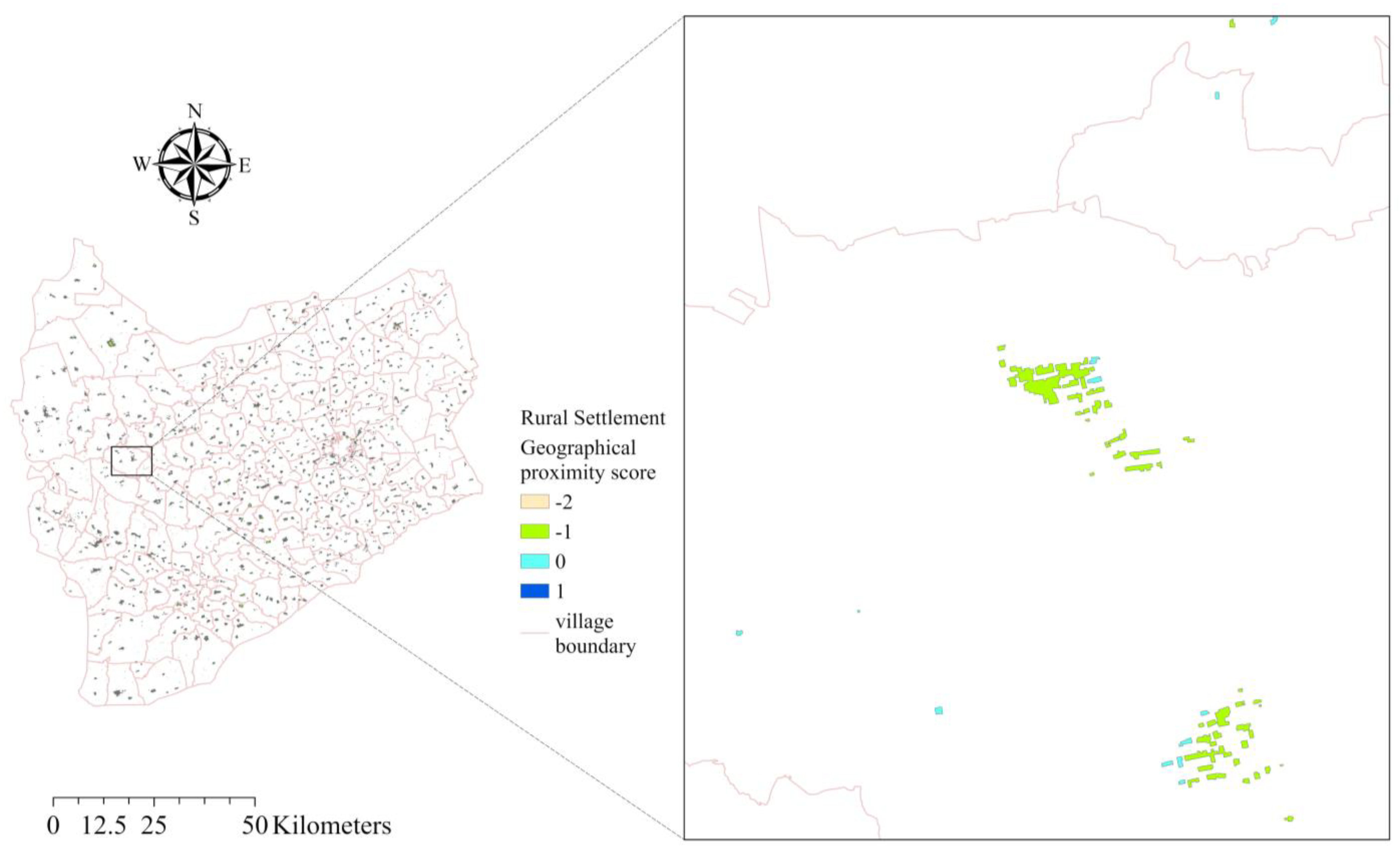
3.1. Results of Village Geographical Proximity Assessment
The availability of living resources for farmers is linked to geographical factors that determine the livelihoods of farmers and influence the potential for the future development of each settlement. To gain a comprehensive understanding of the varying accessibility of resources in rural settlements, a rural geographical assessment was carried out to clarify the variability in the ability to access resources in different rural settlements. According to relevant research [13,16,49], the following conclusions contributed to the rural geographical assessment. First, the distribution of rural settlements is related to factors such as their proximity to urban construction areas, roads, and railways. Therefore, seven indicators were selected according to characteristics of Tong Yu County. Second, as the impacts of these factors were weighted differently, urban areas and highways had the greatest influence, and railroads had the least influence. Previous studies have shown that settlements near towns and highways tend to be more accessible to public resources. Even though some rural settlements are not close to hospitals, schools, or supermarkets, as these settlements are situated close to roads, they can use transportation to reach their destinations. We assume that “distance to the road” is a positive indicator. Other indicators have a negative impact on rural settlement expansion; for example, a short distance to railroads means that the noise generated by passing trains greatly disturbs farmer life. In addition, we learned from the rural settlement research of Tong Yu County that rural settlements close to urban areas demonstrated a smaller possibility of sprawl irregularly, which means that these settlements are better managed and organized by the administrative sector. We assume that “the distance to urban construction land” is a positive indicator. Finally, we provide some details about the impact of buffers on rural settlement evolution. Research on the evolution of rural settlements in Tong Yu County indicates that, owing to the side effects of alkaline land, as the distance between rural settlements and rivers increases, the expansion of rural settlements weakens and then intensifies. Therefore, we set different buffers to evaluate the impact of geographical proximity on rural settlement expansion and evolutionary progress. According to Equation (1), we conceived the rural settlement geographical proximity index (see Table 2). The results of the rural geographical proximity assessment are as follows (see Table 3, Figure 3).
Table 2.
Rural settlement geographical proximity index system.
Table 3.
Statistical results of the rural settlement geo-proximity assessment of different scores.
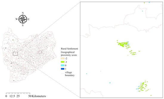
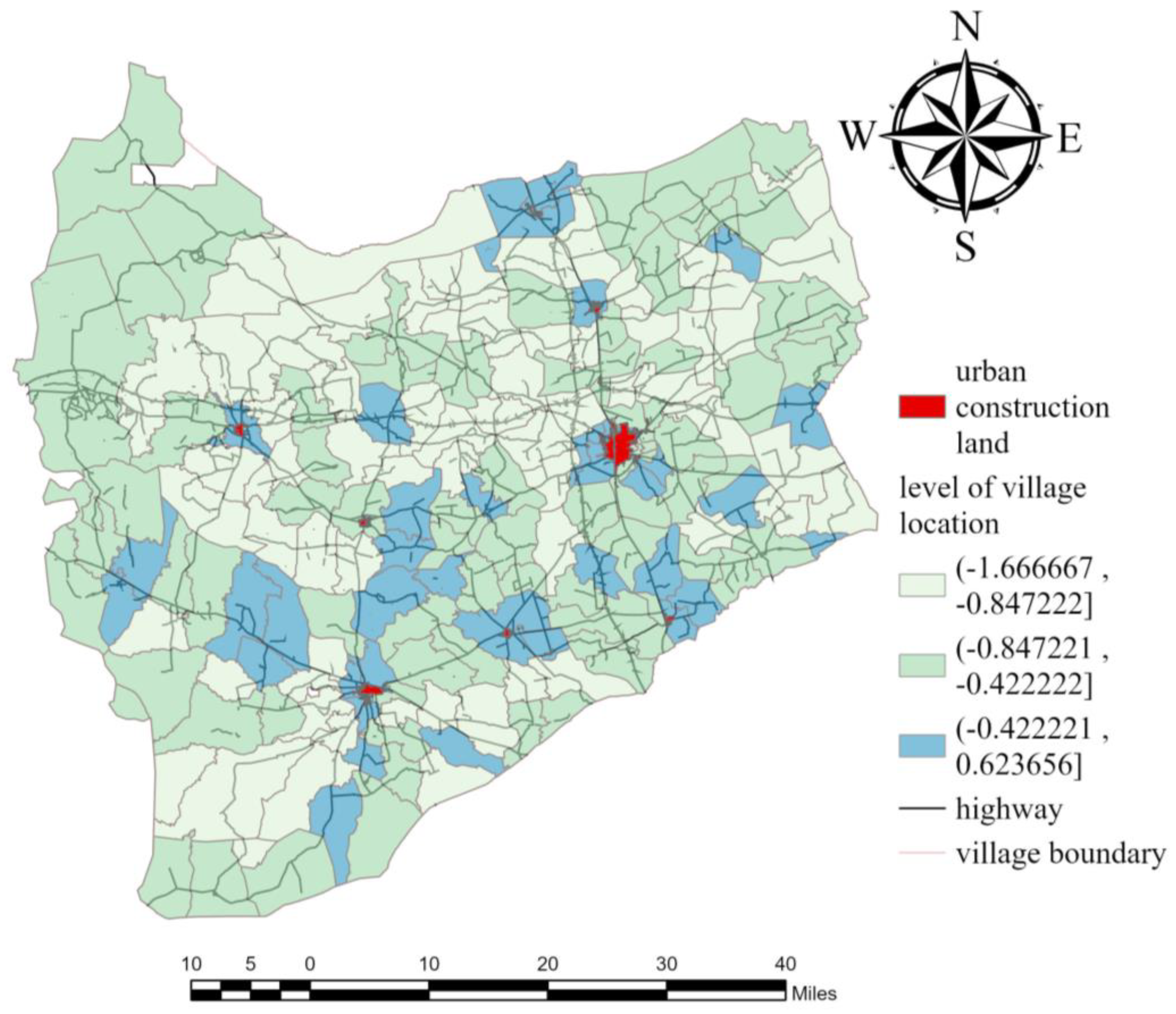
Figure 3.
Results of the geo-proximity assessment for rural settlement patches in Tong Yu County.
The total number of rural settlements in Tong Yu County is 21,110, and the outcome of the rural settlement geographical proximity assessment score was calculated into four grades from low to high: 1, 0, −1, and −2, respectively. A settlement patch with the richest living resources is given a score of 1; if it has a score of −2, then the settlement is relatively under-resourced for subsistence (see Table 3). The scores of the rural settlement patches were statistically averaged village-by-village to obtain the results of a geographical assessment of administrative villages in Tong Yu County (see Table 4).
Table 4.
Statistical results of geographical assessment for villages.
The results of the geographical proximity assessment of rural settlements show that rural settlements with scores of 0 and −1 are widely distributed in all villages in Tong Yu County, in which the area of rural settlements with scores of −1 accounts for more than half of the total area of rural settlements. In contrast, the sum of the areas of the rural settlements with scores of 1 and −2 is less than 10%, which is only distributed in some villages. There is a situation in which patches with scores of 1 and those with scores of −2 are in the same village.
As shown in Figure 4, most of the county government and urban construction sites are in villages with higher ranks. Most of the A-file administrative villages are situated in places with higher-density road networks than other villages in their townships. In contrast, most areas in the C-file have sparse road networks. Compared with the administrative villages in Grade C, the location conditions in Grade A are more favorable.
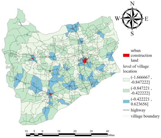
Figure 4.
Results of administrative village geographical assessment in Tong Yu County.
3.2. Results of the Evaluation of Rural Soil and Water Conservation Services
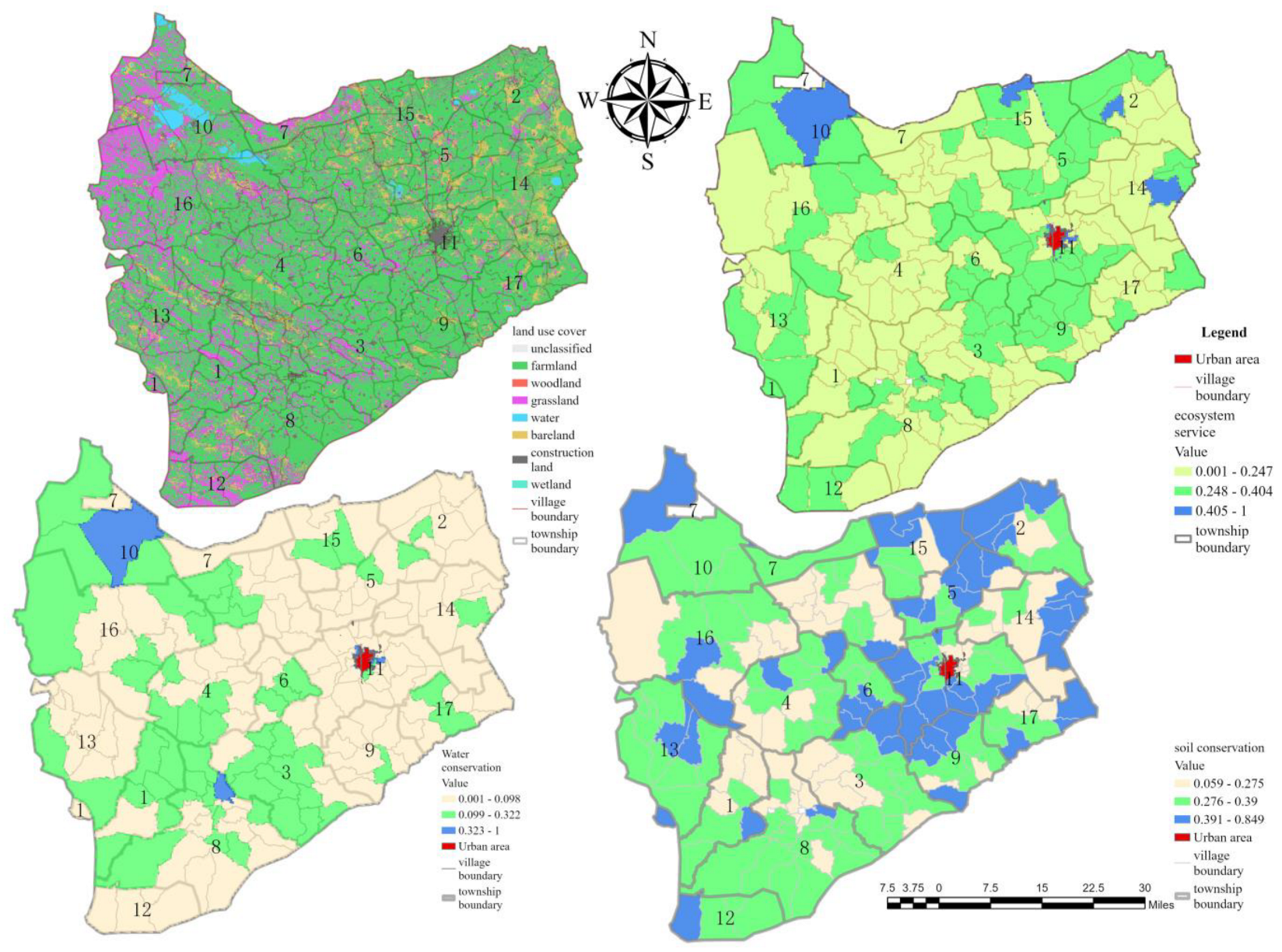
With the help of the ArcGIS Pro Zonal statistics function, the results of water conservation and soil conservation services were averaged by village, and the averages were normalized to obtain the scores of water conservation and soil conservation service capacity, which were divided into three levels via the natural breakpoint method. The two scores were added, and the results were normalized again. Using the natural breakpoint method, the results were divided into three levels, namely, A, B, and C. Therefore, we could obtain Tong Yu County soil and water conservation capacity evaluation results (see Table 5 and Figure 5).
Table 5.
Grading of ecosystem soil and water conservation service capacity of administrative villages in Tong Yu County.
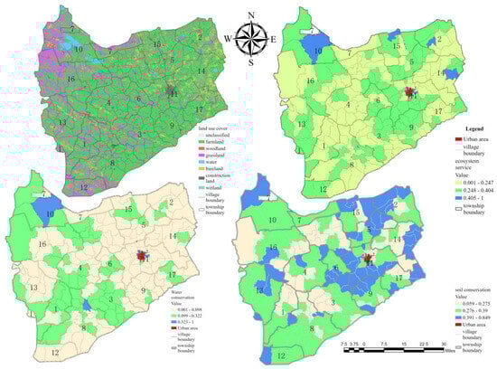
Figure 5.
Water-holding capacity and soil conservation service capacity.
A: Soil conservation capacity or water conservation capacity is more prominent, ecological conditions are more stable, and farmer production and lives threatened by soil erosion are lower. However, there are only four administrative villages of this type, which are located mainly in the northern part of Tong Yu County, accounting for 3.49% of the total area.
B: When the soil or water conservation capacity is at or below the medium level, the risk of soil erosion is at a medium level, and the degree of ecological stability is at an average level. If soil erosion deteriorates, resident living surroundings should be protected. There are 72 administrative villages of this type, which are widely distributed throughout the county, accounting for 40.50% of the total area, and they should be given due attention.
C: Soil retention and water conservation capacity are poor, ecological stability is inadequate, and soil erosion is more severe. Residents are more likely to be affected by soil erosion. This type has 102 administrative villages, which are widely distributed in the townships of Tong Yu County, with a total area of 56.10%. It is necessary to remediate them in zones according to the characteristics of regional ecological instability.
3.3. Results of the Rural Settlement Remediation Scheme
The area of rural settlements in Tong Yu County is 86,071,206.2 m2. According to the kernel density calculation, the average kernel density of rural settlements in Tong Yu County is 2.43 kernel density/m2, the area of rural settlements in the first quartile is 816.98 m2, that in the second quartile is 1642.5 m2, that in the third quartile is 3624 m2, and the average area is 4077 m2 (see Table 6).
Table 6.
Distribution of rural settlement sizes in Tong Yu County.
As shown in Table 6, the distribution characteristics of the small-scale aggregation and large-scale dispersion of rural settlements exist simultaneously within Tong Yu County, with severe patch fragmentation (Figure 6). As the kernel density increases, the area of rural settlement patches increases and then decreases; among them, the aggregation of patches is obvious around Kai Tong Township, the western part of Xinglong Mountain, the eastern and central parts of Shi Hua Dao, and the central part of Tuan Jie Township. Rural settlements with kernel density grades of 1.387–3.21 have the largest patch size but relatively low patch aggregation. Rural settlements with kernel densities less than 1.387 are characterized by small patch sizes and the lowest aggregation. Rural settlements with kernel densities ranging from 8.762 to 18.62 have the highest patch aggregation, and the average value of the patch area is low. The kernel density estimation method better reflects the scale differences of rural settlements in different regions of Tong Yu County.
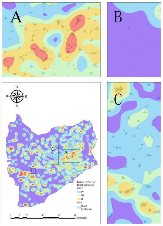
Figure 6.
Distribution of the kernel density and size of rural settlements. Note: A, B, C represent the size and distribution characteristics of rural settlements at different kernel densities.
The remediation strategy was formulated according to the current situation of the scale and density of rural settlements (Table 6). The remediation thresholds use the average value of the area of rural settlements at that level, with the optimized area expected to be the total area of rural settlements reduced after remediation (Table 7). In principle, the remediation of settlements should respect the wishes of farmers, guide farmers to relocate nearby, minimize the cost of relocation, and improve the scattered and fragmented status quo of rural settlements without changing the form of farmer residences to facilitate the provision of services to farmers.
Table 7.
Rural settlement remediation strategies.
3.4. Village Development Program
Combining the rank of the village geographical assessment with the results of the ecosystem soil and water conservation function evaluation grading, Tong Yu County villages were divided into three types: potential enhancement, agglomeration development, and restriction of expansion (see Table 8 and Figure 7).
Table 8.
Details of the village development scheme.
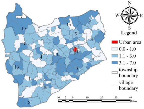
Figure 7.
Spatial distribution of the rural development potential score.
Potential for enhancement: Fifty villages are widely distributed in the townships of Tong Yu County, with a total area of 28.497 square kilometers of rural settlements. The region has no obvious disadvantages regarding soil and water conservation capacity or location conditions and has more space for future development than other villages do. However, this does not mean that the region’s development can be unrestricted; parts of the potential enhancement area still face the risk of soil erosion, and the so-called advantages are merely related to other administrative villages in Tong Yu County. The region should establish differentiated, targeted development programs that consider regional characteristics. For example, for Xiang Hai village, which is in a national nature reserve, the important role of the reserve should be brought into play on the basis of the strict fulfilment of the reserve system, further strengthening the awareness of the masses to protect wetlands and rationally develop the tourism resources in the wetland reserve. The villages in the southern part of the open town should utilize the location of the established towns and promote the transformation of urbanization and intensive use of land in the region actively on the basis of the implementation of the strategy for improving rural settlements.
Clustered development: Three types, totaling 82 villages, are distributed in all townships in Tong Yu County. The total area of rural settlements is 40.625 square kilometers. This type of village has lower geographical assessment ranks or soil and water conservation capacity; therefore, it is necessary to formulate development plans for the different characteristics of administrative villages in this type of area. Specifically, villages with lower geographical assessment ranks but average ecological conditions were included. It is possible to realize large-scale operations and save land resources by organizing unused land. For villages with higher geographical assessment ranks but a higher risk of soil erosion, reasonable measures should be taken to improve the regional soil and water conservation capacity of surplus lands by actively organizing unused land and fragmented rural settlements into larger-scale settlements to attract farmers. These reasonable measures include but are not limited to saline and alkaline land reclamation, specialty agricultural product cultivation, and other means.
Restrictions on expansion: The total area of rural settlements is 16.950 square kilometers, with 44 villages scattered throughout the townships of Tong Yu County. The region has a lower geo-assessment rank and a poor ecological environment, with an extremely high risk of soil erosion, which cannot withstand land use and development. The scale of the original rural settlements should be reduced, the improvement in rural settlements should be promoted on the basis of the wishes of the farmers, and the addition of new arable land and the relocation of foreign farmers into the area should be strictly prohibited. The future development of this area will be based on ecological factors, such as planting drought-resistant plants, improving the soil, and strictly prohibiting land reclamation.
4. Discussion
In this study, a rural settlement optimization program was developed in the context of an ecologically sensitive area. The purpose was to meet the desire of rural residents to improve their living environment and enhance the ecological stability of the area.
4.1. Geographical Assessment Based on Geographical Proximity
The distribution of rural settlements depends on the regional geography, and over time, rural populations tend to gravitate towards better-quality geographical locations [43], which results in differences in location between different geographical locations. Therefore, the geographical evaluation of rural settlements is commonly used in rural settlement optimization schemes. At present, studies on Tong Yu County in northwestern Jilin Province, China, have fully explained the development of rural settlements. Scholars have suggested that the distribution of rural settlements in Tong Yu County is influenced not only by common factors, such as cities, roads, and farmland, but also by saline land, railways, and rivers. With respect to altitude, which is often mentioned in studies in related fields, scholars have concluded that altitude has little effect on the distribution of rural settlements in Tong Yu County. This conclusion can be understood in two ways: on the one hand, Tong Yu County has flat terrain; on the other hand, the higher-elevation areas in Tong Yu County are located in the Xiang Hai National Nature Reserve, where the vegetation is better protected and is not allowed to be cultivated. Therefore, the effect of altitude is not significant. Moreover, our study conducted a village-based geographical assessment, which is based on evaluating the geographical proximity of rural settlements. We found that most of the government’s rural development programs are formulated with the village as the basic unit, and the village-based evaluation better meets the requirements of the government and farmers.
4.2. Ecological Assessment Considering the Safety of Arable Land
Human–land relations in agro-pastoralist intertwined areas have been the focus of scholars, as residents of a region often have to make greater sacrifices to bear the risks associated with human–land conflicts [42]. The threat of soil erosion faced by agricultural and pastoral intertwined zones is particularly serious. To address this issue, we comprehensively used the INVEST-modified RUSLE model and the NPP quantitative assessment model to study the soil and water conservation capacity of typical agricultural and pastoral intertwined areas, and the combination of these two methods fully considered factors such as rainfall and soil types, land-use types, topography, human activities, and vegetation growth conditions and provided a more comprehensive assessment of regional soil and water erosion. According to explanations given by the FAO of the United States, the RUSLE model also performs better than the USLE model in that long rainfall events can saturate the soil, resulting in reduced infiltration and increased erosion runoff. The RUSLE equation is widely used by scientists around the world to calculate the extent of soil erosion, and this method uses five factors, namely, the rainfall erosivity factor, R; the soil erodibility factor, K; the slope length and gradient factor, LS; the cover management factor, C; and the soil and water conservation factor, P. To obtain realistic results, the above factors were calculated on the basis of erosion studies conducted by formal scholars in similar environments [43,44,46,47,48]. Compared with the RUSLE method, the net primary productivity quantitative assessment requires fewer indicators. In more arid agro-pastoral zones where rainfall is scarce, water conservation is more dependent on vegetation cover [50]. The NPP assessment method is based on the health of the vegetation, and although it does not allow for precise calculation of specific nutrient values, it covers all indicators that have an impact on water conservation capacity. Therefore, our results are reliable as a reference for rural development programs.
4.3. Sustainable Land Consolidation Programs
Land consolidation is a widely used solution to the problem of poverty. Poverty-stricken areas are adversely affected by various factors, including locational factors and natural constraints, which have been explored previously [22]. Owing to social and ecological factors, villages in agro-pastoral areas face the problem of a serious loss of population, which is known as “hollowing out”. Therefore, the fragmentation and dispersion of rural settlements have become prominent issues, and unused houses, the potential loss of arable land, and the uncoordinated allocation of resources need to be adjusted. In the past, remediation programs involved mainly the large-scale demolition and reconstruction of settlements; this has been criticized for affecting too many residents, demolishing too large an area, and altering the settlement environment too much [37]. According to relevant studies, these approaches inevitably affect the original neighborhood relationships and cause a waste of land resources [11]. Considering fully the current situation of our study area, our study began with the fragmentation and dispersion of rural settlements and used the kernel density estimation method to study the relationship between scale and density, retaining large-scale settlements and rehabilitating small-scale dispersed patches. Our approach helps solve the problems of patch fragmentation and financial constraints and avoids the encroachment of arable land and unused land, which is a sustainable land resource management strategy.
According to past studies and social surveys, it can be learned that problems such as the fragmentation of rural settlements and the waste of rural land are caused by the hollowing out of the countryside [11,12,15,17,18,21,37,49]. The hollowing out is caused by the massive influx of people from the countryside to the cities, while the loss of people is caused by the lack of employment opportunities. The phenomenon of land wastage will become more serious if the countryside fails to provide employment opportunities for farmers. Therefore, in addition to the implementation of projects for the improvement in rural settlements, we must also actively explore differentiated development paths for ecologically sensitive areas. This means not only the treatment of salinized land, but also the retention of young people based on the development of industries with regional features. At the same time, it is very important to conduct field research on the idle situation of rural settlements in ecologically fragile areas, which is a prerequisite for the implementation of rural settlement improvement projects. In our study, we examined the planning of rural settlements only in terms of size and density, without investigating the vacancy rate. We speculate that the degree of fragmentation of rural settlements is positively correlated with the vacancy rate, but we did not verify this speculation in this paper. We think it is worthwhile to do so.
5. Conclusions
Firstly, this paper proposes a rural settlement development plan based on geographic proximity evaluation and soil and water conservation capacity evaluation, which can categorize existing administrative villages and give suggestions for their development, in view of the lack of planning and fragile ecological environment of rural settlements.
Secondly, this paper proposes a rural settlement improvement program for the fragmentation of rural settlements and serious land waste. This program can significantly improve the problems of land waste and rural settlement fragmentation.
It is expected that a total of 6504 rural settlements will be reduced, the number of patches will be reduced by 30.81%, and the land area saved will be 5.05872365 km2. The results of the soil and water conservation capacity assessment revealed that the area of administrative villages with better soil and water conservation service capacity in Tong Yu County accounted for 3.50%, whereas the area of administrative villages with poor soil and water conservation service capacity accounted for 6.10%.
This paper provides solutions to the problems of fragmented, scattered settlements and a lack of planning and proposes a categorized development plan for administrative villages to cope with soil erosion. The rural settlement remediation strategy proposed in this study can provide a reference for remediation work in ecologically sensitive areas with high settlement fragmentation. However, the data used in this paper were obtained from the results of the land survey program, remote sensing interpretation results, and satellite data, and there was no field survey in Tong Yu County. To carry out the restoration work of rural settlements, the idle situation of rural settlements should be understood. The relationship between the fragmentation of rural settlements and the vacancy rate of rural settlements was not included in this paper. However, this topic is worth studying.
Author Contributions
Conceptualization, methodology, writing—original draft, writing—review and editing, formal analysis, software, and visualization, R.L.; supervision, validation, and funding acquisition, D.W. All authors have read and agreed to the published version of the manuscript.
Funding
This research work was financed by the National Natural Science Foundation of China (No. 42071255).
Data Availability Statement
No new data were created or analyzed in this study. Data sharing is not applicable to this article.
Conflicts of Interest
The authors declare that they have no known competing financial interests or personal relationships that could have appeared to influence the work reported in this paper.
References
- Tan, X.; Duan, J.; Bao, C.; Zhu, H. GIS-based study on spatial layout optimization of rural settlements in Mayang County. Soil Water Conserv. Res. 2010, 17, 177–180+185. (In Chinese) [Google Scholar]
- Tian, Y.; Han, D. Urbanization and the “End of the Village”. J. Soc. Sci. Jilin Univ. 2011, 51, 11–17. (In Chinese) [Google Scholar] [CrossRef]
- Parsipour, H.; Popovic, S.G.; Behzadfar, M.; Skataric, G.; Spalevic, V. Cities Expansion and Land Use Changes of Agricultural and Garden Lands in Peri-Urban Villages (Case Study: Bojnurd). J. Agric. For. 2019, 65. [Google Scholar] [CrossRef]
- Ngo, L.-M.; Anh, T.D. A New Development Model for Traditional Craft Villages in Urban Fringes: A Case Study in Ho Chi Minh City, Vietnam. J. Reg. City Plan. 2021, 32, 99–109. [Google Scholar] [CrossRef]
- Jedwab, R.; Christiaensen, L.; Gindelsky, M. Demography, urbanization and development: Rural push, urban pull and … urban push? J. Urban Econ. 2017, 98, 6–16. [Google Scholar] [CrossRef]
- Do, T.T.; Nguyen, H.T.M.; Vu, T.T. A Comparative Study on the Self-help Approach in Rural Development between Vietnam’s New Rural Development and Korea’s Saemaul Undong. East Asian Econ. Rev. 2016, 20, 91–125. [Google Scholar] [CrossRef]
- Li, Y.; Liu, Y.; Long, H. Spatial and temporal changes in rural population and land use in rural settlements in China. J. Nat. Resour. 2010, 25, 1629–1638. (In Chinese) [Google Scholar]
- Li, J.; Lo, K.; Zhang, P.; Guo, M. Reclaiming small to fill large: A novel approach to rural residential land consolidation in China. Land Use Policy 2021, 109, 105706. [Google Scholar] [CrossRef]
- Long, H.; Qu, Y. Land use transitions and land management: A mutual feedback perspective. Land Use Policy 2018, 74, 111–120. [Google Scholar] [CrossRef]
- Tong, W.; Lo, K.; Zhang, P. Land consolidation in rural China: Life satisfaction among resettlers and its determinants. Land 2020, 9, 118. [Google Scholar] [CrossRef]
- Li, J.; Zhang, P.; Guo, M. Characteristics of spatial distribution of settlements and optimal reorganisation pattern at village scale in Jilin Province. Geosciences 2021, 41, 842–850. (In Chinese) [Google Scholar] [CrossRef]
- Ji, Z.; Xu, Y.; Sun, M.; Liu, C.; Lu, L.; Huang, A.; Duan, Y.; Liu, L. Spatiotemporal characteristics and dynamic mechanism of rural settlements based on typical transects: A case study of Zhangjiakou City, China. Habitat Int. 2022, 123, 102545. [Google Scholar] [CrossRef]
- Li, J.; Li, X.; Kang, X.; Wei, Z.; Wang, J. Characteristics of Spatial Evolution and Influencing Factors of Rural Residential Land in Tongyu County, Jilin Province. Soil Water Conserv. Res. 2017, 24, 221–226. (In Chinese) [Google Scholar] [CrossRef]
- Liu, S.; Xiao, W.; Ye, Y.; He, T.; Luo, H. Rural residential land expansion and its impacts on cultivated land in China between 1990 and 2020. Land Use Policy 2023, 132, 106816. [Google Scholar] [CrossRef]
- Yang, R.; Xu, Q.; Long, H. Spatial distribution characteristics and optimized reconstruction analysis of China’s rural settlements during the process of rapid urbanization. J. Rural Stud. 2016, 47, 413–424. [Google Scholar] [CrossRef]
- Yin, J. Research on Optimizing the Layout of Rural Settlements in Typical Ecologically Fragile Areas. Master’s Thesis, Jilin University, Changchun, China, 2020. (In Chinese). [Google Scholar]
- Xu, Y.; Pu, L.; Zhang, L. Spatial Pattern and the Process of Settlement Expansion in Jiangsu Province from 1980 to 2010, Eastern China. Sustainability 2014, 6, 8180–8194. [Google Scholar] [CrossRef]
- Aamir, Z.; Seddouki, M.; Himmy, O.; Maanan, M.; Tahiri, M.; Rhinane, H. Rural Settlements Segmentation Based on Deep Learning U-Net Using Remote Sensing Images. Int. Arch. Photogramm. Remote Sens. Spat. Inf. Sci. 2023, XLVIII-4/W6-2022, 1–5. [Google Scholar] [CrossRef]
- Li, G.; Fang, C.; Qi, W. Different effects of human settlements changes on landscape fragmentation in China: Evidence from grid cell. Ecol. Indic. 2021, 129, 107927. [Google Scholar] [CrossRef]
- Chen, Z.F.; Li, Y.R.; Liu, Y.S.; Liu, X.Q. Does rural residential land expansion pattern lead to different impacts on eco-environment? A case study of loess hilly and gully region, China. Habitat Int. 2021, 117, 102436. [Google Scholar] [CrossRef]
- Li, F.; Zhang, S.; Yang, J.; Chang, L.; Pu, K.; Wang, Q. Distribution Characteristics of Rural Settlements in the Northern Agricultural and Animal Husbandry Intertwined Zone and Their Impacts on Land Use—The Case of Horqin Left-Wing Middle Banner. Geosciences 2015, 35, 328–333. (In Chinese) [Google Scholar] [CrossRef]
- Wu, C.; Min, J.; Weng, C.; Xin, G. Evaluation of Security Resilience and Spatial Optimisation of Rural Settlements in Ecologically Fragile Mountainous Areas—Taking Aikou Town of Xiushan Tujia and Miao Autonomous County, Chongqing Municipality as an Example. J. Mt. Geol. 2023, 41, 266–279. (In Chinese) [Google Scholar] [CrossRef]
- Li, X.D.; Liu, Y.H.; Li, P.S.; Wu, P.L.; Yu, Z.R. Impact of layout optimization of rural settlements in ecologically fragile areas on the regional ecosystem service function: A case study of Xichang City, Sichuan Province. Acta Ecol. Sin. 2022, 42, 6900–6911. (In Chinese) [Google Scholar] [CrossRef]
- Siqin, C.; Fang, Y.; Wulan, T. Study on the Pattern Characteristics of Settlements in the Agricultural and Animal Husbandry Intertwined Zone of Inner Mongolia and its Formation Process–Taking Zalut Banner as an Example. Arid Zone Resour. Environ. 2016, 30, 75–80. (In Chinese) [Google Scholar] [CrossRef]
- Li, Y.; Li, F.; Chen, C. Characteristics and Driving Forces of Spatial Evolution of Rural Settlements in the Qinghai-Tibetan Plateau Region. Study Mod. Agric. 2021, 42, 1114–1125. (In Chinese) [Google Scholar] [CrossRef]
- Yang, B.; Wang, Z.; Zhang, H.; Tan, L. Characteristics of the evolution of the spatial pattern of rural settlements in high mountainous and poor areas and driving mechanisms. J. Agric. Eng. 2021, 37, 285–293. (In Chinese) [Google Scholar]
- Bewket, W. Soil and water conservation intervention with conventional technologies in northwestern highlands of Ethiopia: Acceptance and adoption by farmers. Land Use Policy 2007, 24, 404–416. [Google Scholar] [CrossRef]
- Kılıc, D.; Yagci, C.; Iscan, F. A GIS-based multi-criteria decision analysis approach using AHP for rural settlement site selection and eco-village design in Erzincan, Turkey. Socio-Econ. Plan. Sci. 2023, 86, 101478. [Google Scholar] [CrossRef]
- Yin, J.; Li, H.; Wang, D.; Liu, S. Optimization of Rural Settlement Distributions Based On the Ecological Security Pattern: A Case Study of Da’an City in Jilin Province of China. Chin. Geogr. Sci. 2020, 30, 824–838. [Google Scholar] [CrossRef]
- Blaikie, P.; Brookfield, H. Land Degradation and Society; Routledge: London, UK, 2015. [Google Scholar]
- Cunha, E.R.D.; Santos, C.A.G.; Silva, R.M.D.; Panachuki, E.; Oliveira, P.T.S.; Oliveira, N.S.; Falcao, K.D.S. Assessment of current and future land use/cover changes in soil erosion in the Rio da Prata basin (Brazil). Sci. Total Environ. 2022, 818, 151811. [Google Scholar] [CrossRef]
- Li, D.; Wang, D.; Li, H.; Zhang, S.; Tian, W. The Effects of Rural Settlement Evolution on the Surrounding Land Ecosystem Service Values: A Case Study in the Eco-Fragile Areas, China. ISPRS Int. J. Geo-Inf. 2017, 6, 49. [Google Scholar] [CrossRef]
- Wang, G.; Zhang, Q.; Zheng, H.; Yang, J.; Xiao, R. Analysis of soil erosion trends and their socio-economic drivers in Jiangxi Province, 1987–2013. Ecol. Sci. 2017, 36, 115–120. (In Chinese) [Google Scholar] [CrossRef]
- Ma, T.; Wang, Y.; Liao, H.; Li, T. Vulnerability Evaluation of the Livelihoods of Poor Farmers in the Three Gorges Reservoir Area under Ecological Degradation—Taking Fengjie County of Chongqing Municipality as an Example. J. Southwest Univ. (Nat. Sci. Ed.) 2019, 41, 10–17. (In Chinese) [Google Scholar] [CrossRef]
- Peng, S. 1-km Monthly Precipitation Dataset for China (1901–2022); National Tibetan Plateau Data Center: Beijing, China, 2020. [Google Scholar] [CrossRef]
- Zhou, X.; Li, H.; Yin, J. Study on the Evolution of Vulnerability of Rural Territorial System and Classification of Its Causal Types in Jilin Province. Study Mod. Agric. 2022, 43, 679–690. (In Chinese) [Google Scholar] [CrossRef]
- Li, S.; Fang, Y.; Zou, C. Rural multidimensional development patterns and typological revitaliza tion strategy in semiarid and poverty alleviated areas of Northeast China: Taking Tongyu County as an example. Prog. Geosci. 2024, 43, 504–516. (In Chinese) [Google Scholar] [CrossRef]
- Huang, X.; Yang, J. The 30 m Annual Land Cover Datasets and Its Dynamics in China from 1985 to 2022; Zenodo: Geneva, Switzerland, 2023. [Google Scholar] [CrossRef]
- Nachtergaele, F.; van Velthuizen, H.; Verelst, L.; Wiberg, D.; Henry, M.; Chiozza, F.; Yigini, Y.; Aksoy, E.; Batjes, N.; Boateng, E. Harmonized World Soil Database Version 2.0; Food and Agriculture Organization of the United Nations: Rome, Italy, 2023. [Google Scholar]
- NASA. ASTER Global Emissivity Dataset, 100-meter and 1-km, HDF5 [Data set]. NASA EOSDIS Land Process. DAAC 2014. [Google Scholar]
- Jara-Rojas, R.; Bravo-Ureta, B.E.; Engler, A.; Díaz, J. An analysis of the joint adoption of water conservation and soil conservation in Central Chile. Land Use Policy 2013, 32, 292–301. [Google Scholar] [CrossRef]
- Li, F.; Zhang, S.; Yang, J.; Bu, K.; Wang, Q.; Tang, J.; Chang, L. The effects of population density changes on ecosystem services value: A case study in Western Jilin, China. Ecol. Indic. 2016, 61, 328–337. [Google Scholar] [CrossRef]
- Jian, Z.; Sun, Y.; Wang, F.; Zhou, C.; Pan, F.; Meng, W.; Sui, M. Soil conservation ecosystem service supply-demand and multi scenario simulation in the Loess Plateau, China. Glob. Ecol. Conserv. 2024, 49, e02796. [Google Scholar] [CrossRef]
- Sharp, R.; Tallis, H.; Ricketts, T.; Guerry, A.; Wood, S.; Chaplin-Kramer, R.; Nelson, E.; Ennaanay, D.; Wolny, S.; Olwero, N. InVEST 3.2. 0 user’s guide. Nat. Cap. Proj. 2015, 133. [Google Scholar]
- Gao, Z.; Wu, D.; Zhang, K.; Lin, N.; Zou, C. Technical method and application of large-scale ecological protection red line delineation for water conservation based on donor-acceptor relationship. Environ. Ecol. 2019, 1, 1–7+14. (In Chinese) [Google Scholar]
- Zhang, W.; Fu, J. Estimation of rainfall erosivity from different types of rainfall data. Resour. Sci. 2003, 25, 35–41. (In Chinese) [Google Scholar]
- Li, J.L.; Sun, R.; Xiong, M.Q.; Yang, G. Estimation of soil erosion based on the RUSLE model in China. Acta Ecol. Sin. 2020, 40, 3473–3485. [Google Scholar] [CrossRef]
- Marques, S.M.; Campos, F.S.; David, J.; Cabral, P. Modelling Sediment Retention Services and Soil Erosion Changes in Portugal: A Spatio-Temporal Approach. ISPRS Int. J. Geo-Inf. 2021, 10, 262. [Google Scholar] [CrossRef]
- Li, D. Study on the Spatial Coupling Relationship between Land Use Evolution of Rural Settlements and Land Salinization in Ecologically Fragile Areas. Ph.D. Thesis, Jilin University, Changchun, China, 2017. [Google Scholar]
- Wang, H.; Zhang, C.; Li, L.; Yun, W.; Ma, J.; Gao, L. Delimitating the Ecological Spaces for Water Conservation Services in Jilin Province of China. Land 2021, 10, 1029. [Google Scholar] [CrossRef]


Disclaimer/Publisher’s Note: The statements, opinions and data contained in all publications are solely those of the individual author(s) and contributor(s) and not of MDPI and/or the editor(s). MDPI and/or the editor(s) disclaim responsibility for any injury to people or property resulting from any ideas, methods, instructions or products referred to in the content. |
© 2024 by the authors. Licensee MDPI, Basel, Switzerland. This article is an open access article distributed under the terms and conditions of the Creative Commons Attribution (CC BY) license (https://creativecommons.org/licenses/by/4.0/).