Quality Analysis for Conservation and Integral Risk Assessment of the Arribes del Duero Natural Park (Spain)
Abstract
:1. Introduction
Study Area
2. Materials and Methods
2.1. Quality Analysis for Conservation
2.1.1. Geological Heritage Analysis
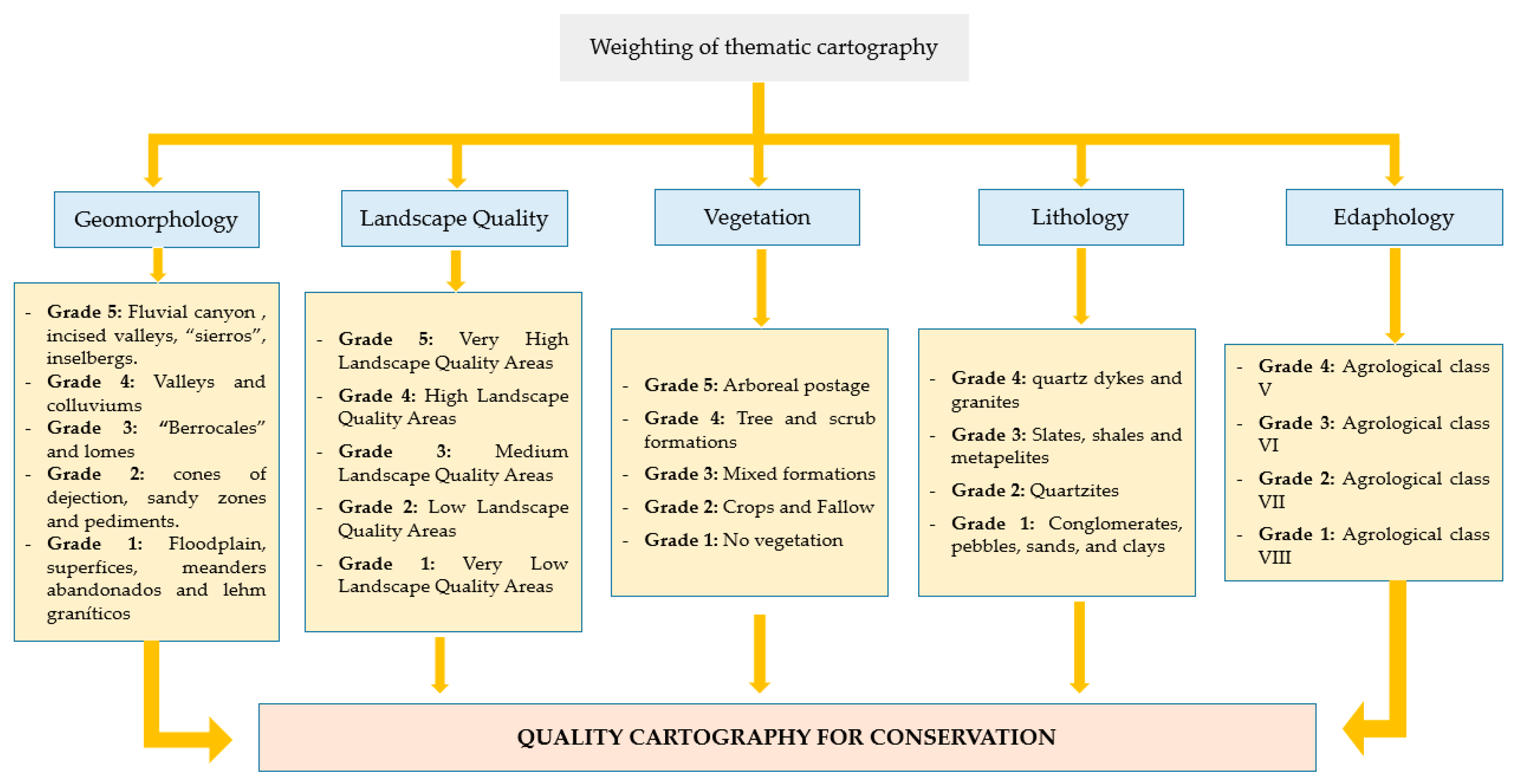
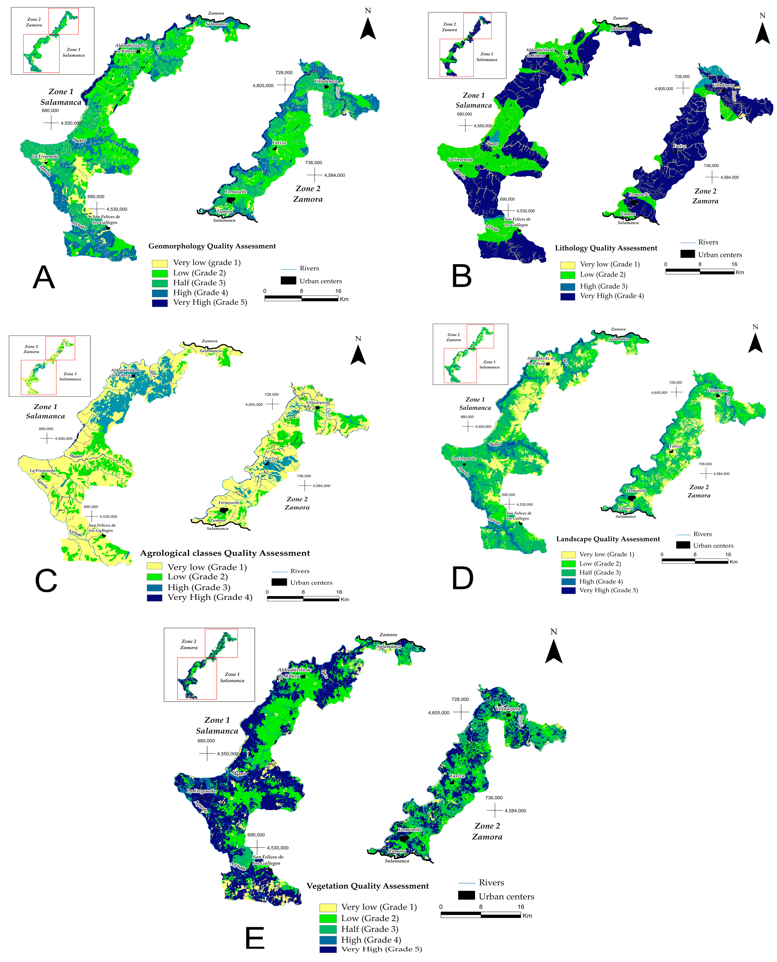
- Geomorphology. This parameter is assessed considering the criteria of singularity and degree of conservation. This assessment establishes the distribution of units of geomorphological interest, considering the degree of preservation of the units in relation to the degree of anthropic alteration. The spectacular nature of the geoforms and the percentage of vegetation cover have also been considered, which, if high, diminishes the real geomorphological value due to its lesser perception.
- Lithology. The evaluation of this parameter considers those lithological formations that have a certain prominence in the natural environment, from their perceptual level to their intrinsic characteristics.
- Edaphology. The interest in soil conservation considers productivity according to agricultural constraints and other factors such as slope and erosion.
2.1.2. Landscape Quality Analysis
- 1.
- Geomorphological Factor: This is the most influential component, as the landform largely determines the configuration of the terrain. Certain landforms, such as ridges, river valleys, canyons, cliffs, or deeply incised valleys, tend to have a higher landscape value. In contrast, other forms, like erosion surfaces, pediments, or terraces, receive less favourable assessments. The analysis of this factor requires weighting the following specific parameters (Table 1) that describe the geomorphological characteristics of the area:
- (A)
- Geomorphological Domains: These define the spatial distribution of relief units in relation to nearby terrains, considering the different modelling processes that have shaped the earth’s surface.
- (B)
- Slopes: Obtained from the 1 m Digital Terrain Model (DTM), generating a raster layer.
- (C)
- Sinusoidality: This parameter evaluates the curvature of the terrain lines. Its calculation employs an index that compares the area and perimeter of polygons defined by contour lines, using Geographic Information System (GIS) techniques.
- 2.
- Lithological Factor: Lithology significantly influences the colour composition of the landscape, which is crucial for assessing the intrinsic quality of a natural environment. The landscape’s colour is determined by various rock outcrops, with lighter tones generally being more appreciated than darker ones. Based on the present lithological units and their mineral composition, they are reclassified into leucocratic or melanocratic mineral-rich materials.
- 3.
- Hydrological Factor: The presence of bodies of water adds significant value to the surrounding natural environment. This factor includes rivers, lakes, and reservoirs, which create wetland areas capable of supporting a wide variety of organisms, enhancing the naturalness of the landscape. In this context, higher values are assigned to areas near watercourses (value 4), compared to those near water bodies (value 2), as the former have greater perceptual significance both visually and acoustically, due to the movement of the water.
- 4.
- Morphostructural Relief Factor: This factor refers to elements of the relief that have particular perceptual relevance, such as lithostructural landforms. These include notable geological formations like folds, deeply incised valleys, or river canyons, which are assigned a score of 10 due to their distinctive character.
- 5.
- Vegetation Factor: This factor is vital in the analysis due to the high variability in vegetation and its different structures. Two main aspects are analysed and weighted (Table 2):
- (A)
- Specific Composition: This parameter refers to the various plant associations present in the area, characterised by two factors: plant grouping and diversity. Plant grouping is evaluated based on the ecological value of the community, which depends on the dominant species in each association and its influence. Diversity, on the other hand, reflects how the variety of species helps reduce the monotony of the landscape, promoting the presence of mosaic distributions and highlighting the environment’s uniqueness.
- (B)
- Vegetation Structure: This parameter analyses the distribution and presence of different components within each plant community, evaluating these based on density and stratification. Density refers to the horizontal structure of the vegetation, focusing on the number of plants per unit area. The Fraction of Canopy Cover (FCC) is used for its evaluation, classified into three categories (Table 2). Stratification, on the other hand, examines the vertical structure of the vegetation, differentiating three possible height strata (herbaceous, shrub, and tree).
+ Structural relief factor + ∑ Vegetation factors
- (A)
- Geological Heritage: The presence of Geological Points of Interest (GPI) is considered, which are grouped and assigned a weight of 10.
- (B)
- Biological Heritage: This includes both plant and animal heritage. Regarding plant heritage, areas containing significant plant species are valued, with an influence radius of 100 m, and assigned a value of 4. For animal heritage, critical areas and points of presence of species of interest are also considered within a 100 m radius. Unlike plant areas, these zones are given a lower score (value 2) due to their more restricted visual impact.
- (C)
- Ecological Heritage: This encompasses sectors of ecological interest, classified according to various criteria:
- -
- Reserve Areas, distinguished by their high natural quality, are assigned a value of 6.
- -
- Special Protection Areas for Birds (SPA) are valued with a score of 4.
- -
- Sites of Community Interest (SCI) are valued with a score of 2.
- Landscape. This parameter is assessed on the basis of the cartography of landscape quality. This cartography is obtained from the weighting of the visual quality of a series of factors (orientations, slopes, vegetation, urban centres, and PIG, among others). The criteria for determining the visual quality of the different parameters are the perceptual singularity of the elements, their diversity, and to a lesser extent, their chromatism. The grades of the landscape unit are shown in Figure 3.
- Vegetation. This parameter has been assessed on the basis of the scientific value and uniqueness of the plant species in terms of their notoriety in the environment and their environmental and socio-economic importance, i.e., the ecological value of each plant grouping. The assessment is shown in Figure 3.
(Landscape Quality Cartography) + 5 (Vegetation Cartography) + 4
(Lithological Cartography) + 4 (Agrological Cartography)/23
2.2. Integrated Risk Analysis
- -
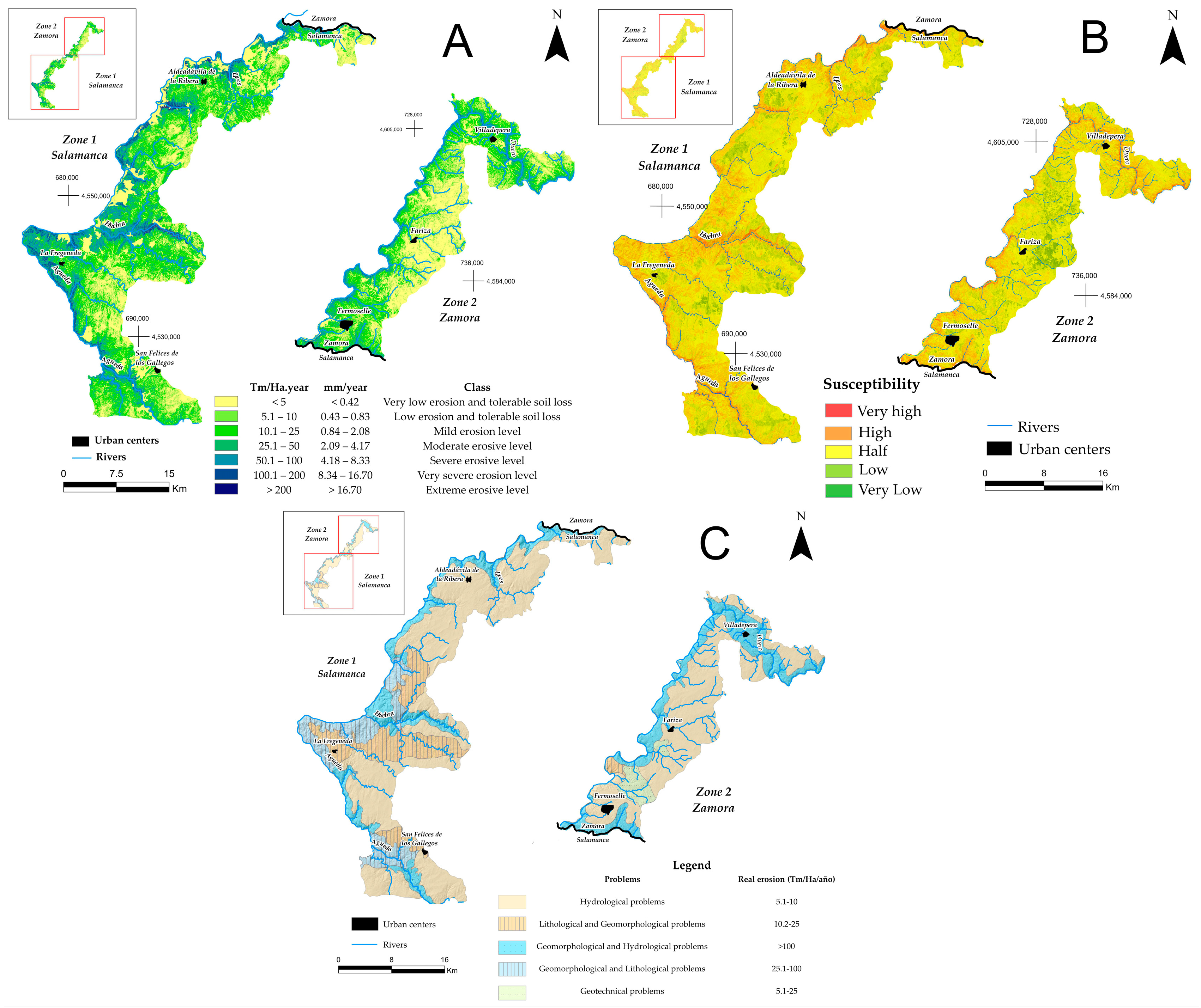
- Cartography of Erosive Risks: This map indicates the current risk of water erosion, considering the erosivity, erodibility, topographic, and vegetation cover factors. For this cartography, the modified version of RUSLE [45] has been used to estimate the average annual soil loss under different conditions of use, climatic variation, relief, and use of conservation practices. This model is expressed by Equation (5):
- -
- Gravitational Risk Cartography: In this map, the following are observed with a greater probability of slope movement. The study of gravitational hazards is carried out by means of susceptibility cartography, which serves to establish the possible incidence of natural processes in a given area. It is also a risk prevention measure through the adoption of protective measures for exposed elements when there is no other option [47].
- -
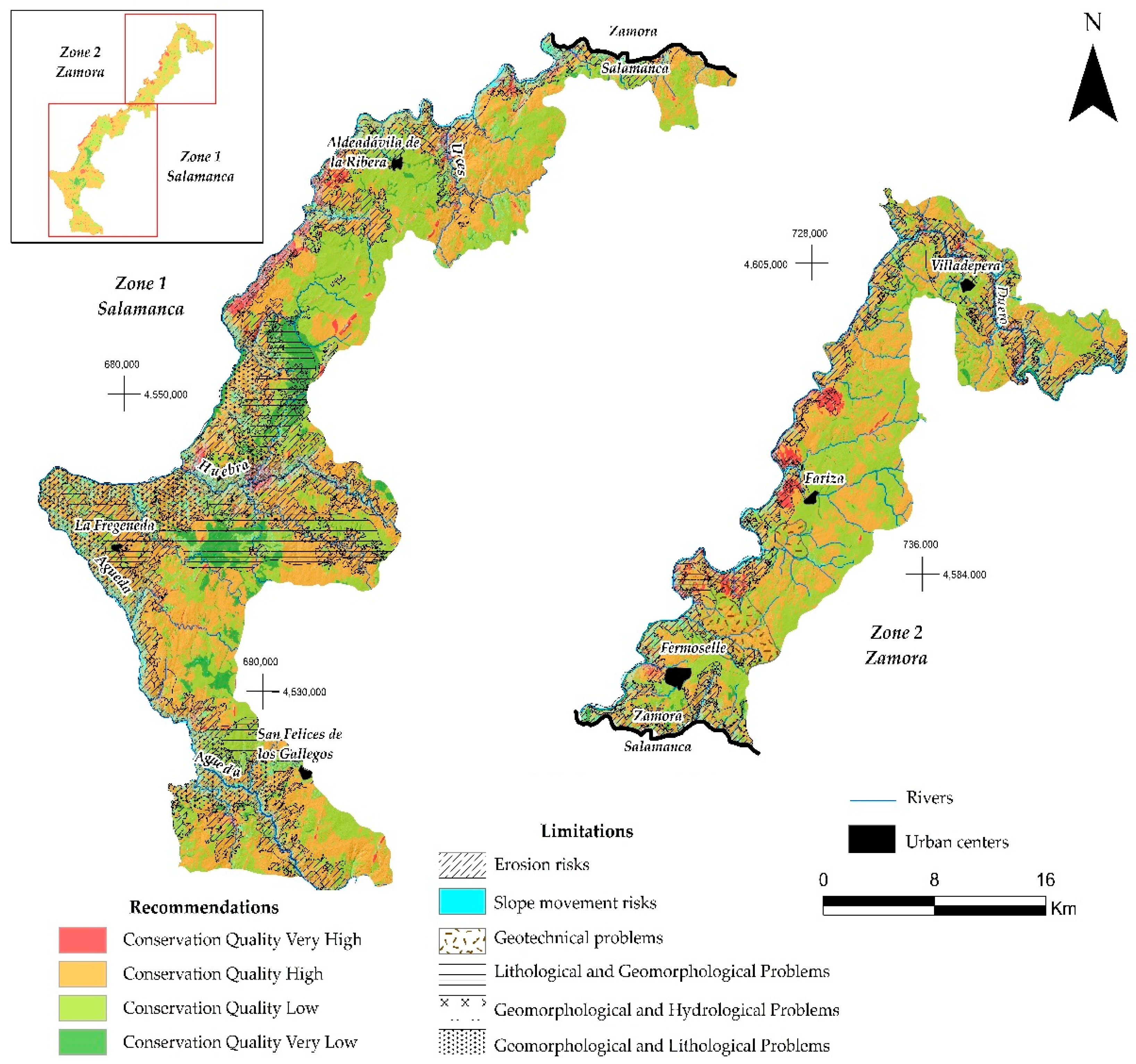
- Natural Risk Cartography: This is based on the sectoral analysis of external geodynamic processes that can potentially lead to active processes. This cartography spatially predicts the existence of a given hazard risk, based on geotechnical zoning and erosion rates. The natural risks that can be observed are the following: hydrological problems; lithological and geomorphological problems; geomorphological and hydrological problems; geomorphological and lithological problems; and geotechnical problems. These problems have been classified and distinguished according to their lithological, hydrological, and geotechnical characteristics, and the actual erosion rates have also been considered.
3. Results
3.1. Geological Heritage Cartography
3.2. Landscape Quality Cartography
3.3. Erosive, Gravitational, and Natural Hazard Cartography
3.4. Quality Cartography for Conservation
3.5. Integrated Risk Cartography
3.6. Cartography of Recommendations and Limitations
4. Discussions
5. Conclusions
- Strategic Environmental Assessment (SEA), as a tool for sustainable development, promotes sustainable urban and territorial development, in which geological risks—reflected in maps—are integrated with quality analysis for conservation. All this is completed through the cartographic analysis of available resources, allowing an integrated vision of the territory.
- Planning in natural areas with a risk-based approach: Territorial planning within natural areas makes it possible to delimit areas of greater protection and to define those with restrictions on use. This is based on the cartography elaborated, incorporating in a novel way natural risk as an essential part of the SEA.
- Quality cartography for conservation: Quality cartography makes it possible to identify the areas of the territory that should be protected according to their degree of conservation. Four zones are distinguished:
- -
- Very high conservation: corresponds to areas such as the Duero canyon, the narrow valleys of the most plentiful rivers, and mountain ranges such as Cerezal de Peñahorcada.
- -
- High conservation: found in valley areas, such as near La Fregeneda.
- -
- Low conservation: located in foothill areas, such as in the municipality of Aldeadávila de la Ribera.
- -
- Very low conservation: covers valley bottoms and degraded eroded areas, such as those of Cerezal de Peñahorcada and Mieza.
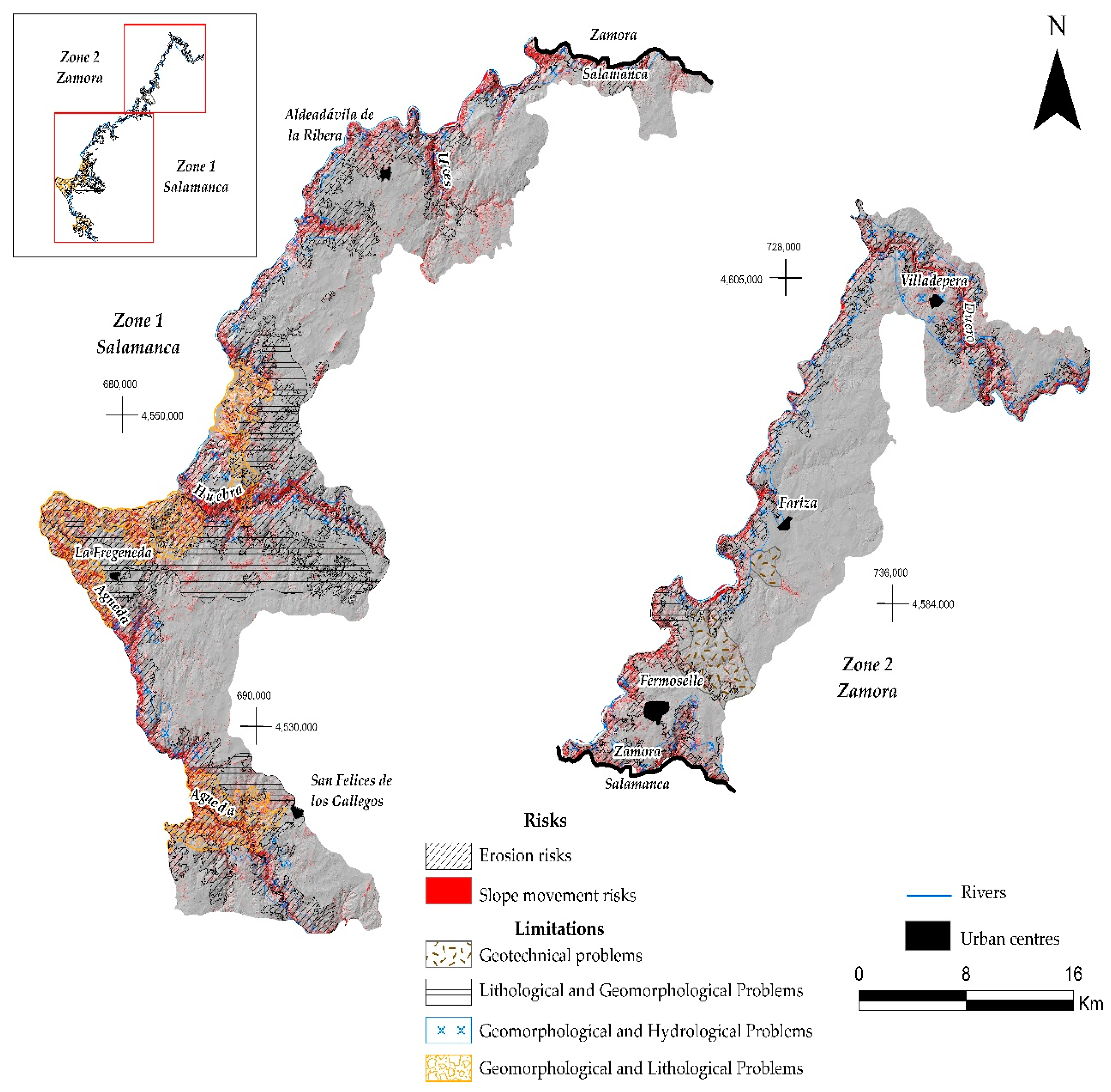
- Integrated risk cartography: This cartography identifies land-use limitations and provides useful information from the project phase, supporting territorial planning and management strategies. High-risk areas—both erosion and slope movement—are concentrated in the Duero canyon and in the narrow valleys of the most important tributaries. Various types of problems are also found:
- -
- Lithological and geomorphological: in areas with gentle slopes and highly fractured impermeable materials (e.g., Sierra de Peñahorcada).
- -
- Geomorphological and hydrogeological: in areas with steep slopes and clayey or arcose materials, with landslides and rock falls.
- -
- Combined lithological and geomorphological: in areas with materials that present planes of weakness, such as stratification or diaclasation.
- -
- Geotechnical: located in areas close to Fermoselle, with loose and permeable materials.
- Cartography of recommendations and limitations for use: this type of cartography allows the managers of the Protected Natural Space (ENP) to define the most suitable locations for human activities, taking into account both the conservation category and the limitations derived from natural risks.
- -
- In areas of very high conservation and high risk, uses are compatible with conservation, although there may be sectors with restrictions (e.g., Cerezal de Peñahorcada).
- -
- Areas of high conservation quality present medium or low erosive risks (such as gully formation), so the implementation of activities is conditioned.
- -
- In low-quality areas, the degree of protection is lower, and most anthropogenic activities are acceptable.
- -
- Finally, in very low-quality zones, there are very few limitations on use, allowing activities such as livestock or agriculture without significant restrictions.
Author Contributions
Funding
Data Availability Statement
Acknowledgments
Conflicts of Interest
References
- Cardinale, B.J.; Duffy, J.E.; Gonzalez, A.; Hooper, D.U.; Perrings, C.; Venail, P.; Naeem, S. Biodiversity loss and its impact on humanity. Nature 2012, 486, 59–67. [Google Scholar] [CrossRef] [PubMed]
- Annex, V.I.I.I. Report of the Plenary of the Intergovernmental Science-Policy Platform on Biodiversity and Ecosystem Services on the Work of its Third Session; IPBES: Bonn, Germany, 2019. [Google Scholar]
- Martínez, M.L.; Intralawan, A.; Vázquez, G.; Pérez–Maqueo, O.; Sutton, P.; Landgrave, R. The Coasts of Our World: Ecological, Economic and Social Importance. Ecol. Econ. 2007, 63, 254–272. [Google Scholar] [CrossRef]
- Adger, W.N.; Hughes, T.P.; Folke, C.; Carpenter, S.R.; Rockstrom, J. Social-ecological resilience to coastal disasters. Science 2005, 30, 1036–1039. [Google Scholar] [CrossRef]
- Jin, X.; Luan, W.; Yang, J.; Yue, W.; Wan, S.; Yang, D.; Xiao, X.; Xue, B.; Dou, Y.; Lyu, F.; et al. From the Coast to the Interior: Global Economic Evolution Patterns and Mechanisms. Humanit. Soc. Sci. Commun. 2023, 10, 723. [Google Scholar] [CrossRef]
- Burke, L.; Kura, Y. Pilot Analysis of Global Ecosystems: Coastal Ecosystems; World Resources Institute: Washington, DC, USA, 2000. [Google Scholar]
- Bender, S. Primer on Natural Hazard Management in Integrated Regional Development Planning; Organization of American States, Department of Regional Development and Environment; Executive Secretariat for Economic and Social Affairs: Washington, DC, USA, 1991. [Google Scholar]
- Alexander, D. Natural Disasters; Routledge: London, UK, 2018. [Google Scholar]
- Mileti, D. Disasters by Design: A Reassessment of Natural Hazards in the United States; Joseph Henry Press: Washington, DC, USA, 1999. [Google Scholar]
- Adger, W.N. Vulnerability. Glob. Environ. Change 2006, 16, 268–281. [Google Scholar] [CrossRef]
- Cutter, S.L.; Barnes, L.; Berry, M.; Burton, C.; Evans, E.; Tate, E.; Webb, J. A Place–Based Model for Understanding Community Resilience to Natural Disasters. Glob. Environ. Change 2008, 18, 598–606. [Google Scholar] [CrossRef]
- Burby, R.J.; May, P.J. Making Governments Plan: State Experiments in Managing Land Use; JHU Press: Baltimore, MD, USA, 1997. [Google Scholar]
- Godschalk, D.R. Urban Hazard Mitigation: Creating Resilient Cities. Nat. Hazards Rev. 2003, 4, 136–143. [Google Scholar] [CrossRef]
- Safani, J.; Matsuoka, T. Soft–Geotechnical Zone Determination Using Surface–Wave for Geotechnical Hazard Mitigation. Procedia Environ. Sci. 2013, 17, 354–360. [Google Scholar] [CrossRef]
- Haeri, S.M. The Role of Geotechnical Engineering in Sustainable and Resilient Cities. Sci. Iran. 2016, 23, 1658–1674. [Google Scholar] [CrossRef]
- Mendoza-González, G.; Martínez, M.; Lithgow, D.; Pérez-Maqueo, O.; Simonin, P. Land use change and its effects on the value of ecosystem services along the coast of the gulf of mexico. Ecol. Econ. 2012, 82, 23–32. [Google Scholar] [CrossRef]
- Mehvar, S.; Filatova, T.; Dastgheib, A.; De Ruyter Van Steveninck, E.; Ranasinghe, R. Quantifying Economic Value of Coastal Ecosystem Services: A Review. J. Mar. Sci. Eng. 2018, 6, 5. [Google Scholar] [CrossRef]
- Baby, S.; Nagyvaradi, L.; Balassa, B. Choropleth mapping and interpolation technique to analyze the demographic influence on kuwait’s coastal morphological landscape. Environ. Eng. Manag. J. EEMJ 2016, 15, 1. [Google Scholar] [CrossRef]
- Antrop, M. Why landscapes of the past are important for the future. Landsc. Urban Plan. 2005, 70, 21–34. [Google Scholar] [CrossRef]
- Martínez-Graña, A.M.; Goy, J.L.; Zazo, C. Cartographic-environmental analysis of the landscape in natural protected parks for his management using GIS. Application to the natural parks of the “Las Batuecas-Sierra de Francia” and “Quilamas” (Central System, Spain). J. Geogr. Inf. Syst. 2013, 5, 54–68. [Google Scholar] [CrossRef]
- Nohl, W. Sustainable landscape use and aesthetic perception–preliminary reflections on future landscape aesthetics. Landsc. Urban Plan. 2001, 54, 223–237. [Google Scholar] [CrossRef]
- Martín Serrano, A. El relieve del Macizo Hespérico: Génesis y cronología de los principales elementos morfológicos. Cuad. Lab. Xeolóxico Laxe 1994, 19, 37–56. [Google Scholar]
- Ledda, A.; Di Cesare, E.A.; Satta, G.; Cocco, G.; De Montis, A. Integrating adaptation to climate change in regional plans and programmes: The role of strategic environmental assessment. Environ. Impact Assess. Rev. 2021, 91, 106655. [Google Scholar] [CrossRef]
- Wende, W.; Bond, A.; Bobylev, N.; Stratmann, L. Climate change mitigation and adaptation in strategic environmental assessment. Environ. Impact Assess. Rev. 2012, 32, 88–93. [Google Scholar] [CrossRef]
- Geneletti, D. A conceptual approach to promote the integration of ecosystem services in strategic environmental assessment. J. Environ. Assess. Policy Manag. 2015, 17, 1550035. [Google Scholar] [CrossRef]
- Rodrigues, T.; Geißler, G.; Montaño, M. Addressing climate change in Berlin’s local land-use plans through strategic environmental assessment and knowledge brokering. Environ. Impact Assess. Rev. 2024, 110, 107651. [Google Scholar] [CrossRef]
- Goonesekera, S.M.; Olazabal, M. Climate adaptation indicators and metrics: State of local policy practice. Ecol. Indic. 2022, 145, 109657. [Google Scholar] [CrossRef]
- Bradaschia, M.G.; Longato, D.; Maragno, D.; Musco, F. Climate change adaptation mainstreaming through strategic environmental assessments. An in-depth analysis of environmental indicators from spatial plans in Friuli Venezia Giulia Region (Italy). Environ. Impact Assess. Rev. 2024, 109, 107650. [Google Scholar] [CrossRef]
- Arabameri, A.; Saha, S.; Mukherjee, K.; Blaschke, T.; Chen, W.; Ngo, P.T.T.; Band, S.S. Modeling Spatial Flood Using Novel Ensemble Artificial Intelligence Approaches in Northern Iran. Remote Sens. 2020, 12, 3423. [Google Scholar] [CrossRef]
- Esmaili, R.; Karipour, S.A. Comparison of weighting methods of multicriteria decision analysis (MCDA) in evaluation of flood hazard index. Nat. Hazards 2024, 120, 8619–8638. [Google Scholar] [CrossRef]
- Rocha, C.; Antunes, C.; Catita, C. Coastal vulnerability assessment due to sea level rise: The case study of the Atlantic coast of mainland Portugal. Water 2020, 12, 360. [Google Scholar] [CrossRef]
- Kunte, P.D.; Jauhari, N.; Mehrotra, U.; Kotha, M.; Hursthouse, A.S.; Gagnon, A.S. Multi–Hazards Coastal Vulnerability Assessment of Goa, India, Using Geospatial Techniques. Ocean Coast. Manag. 2014, 95, 264–281. [Google Scholar] [CrossRef]
- Stalhandske, Z.; Steinmann, C.B.; Meiler, S.; Sauer, I.J.; Vogt, T.; Bresch, D.N.; Kropf, C.M. Global Multi–Hazard Risk Assess-501 ment in a Changing Climate. Sci. Rep. 2024, 14, 5875. [Google Scholar] [CrossRef]
- Marino Alfonso, J.L.; Poblete Piedrabuena, M.Á.; Beato Bergua, S.; Herrera Arenas, D. Geotourism itineraries and augmented reality in the geomorphosites of the Arribes del Duero Natural Park (Zamora Sector, Spain). Geoheritage 2021, 13, 16. [Google Scholar] [CrossRef]
- Martinez-Grañab, A.M.; Goy, J.L.; Cimarra, C. 2D to 3D geologic mapping transformation using virtual globes and flight simulators and their applications in the analysis of geodiversity in natural areas. Environ. Earth Sci. 2015, 73, 8023–8034. [Google Scholar] [CrossRef]
- Martínez-Graña, A.M.; Goy, J.L.; González-Delgado, J.Á.; Cruz, R.; Sanz, J.; Cimarra, C.; De Bustamante, I. 3D virtual itinerary in the geological heritage from natural areas in Salamanca-Ávila-Cáceres, Spain. Sustainability 2018, 11, 144. [Google Scholar] [CrossRef]
- Moreira, F.; Queiroz, I.; Aronson, J. Restoration principles applied to cultural landscapes. J. Nat. Conserv. 2006, 14, 217–224. [Google Scholar] [CrossRef]
- Meini, M.; Di Felice, G.; Petrella, M. Geotourism Perspectives for Transhumance Routes. Analysis, Requalification and Virtual Tools for the Geoconservation Management of the Drove Roads in Southern Italy. Geosciences 2018, 8, 368. [Google Scholar] [CrossRef]
- Peura, M.; Eyvindson, K.; Burgas, D.; Mönkkönen, M.; Raatikainen, K.J.; Kotiaho, J.S. Cost-effective biodiversity protection through multiuse-conservation landscapes. Landsc. Ecol. 2024, 39, 48. [Google Scholar] [CrossRef]
- Stoffelen, A.; Vanneste, D. An integrative geotourism approach: Bridging conflicts in tourism landscape research. Tour. Geogr. 2015, 17, 544–560. [Google Scholar] [CrossRef]
- Martínez Graña, A.M. Estudio Geológico Ambiental para la Ordenación de los Espacios Naturales de “Las Batuecas-Sierra de Francia” y “Quilamas”. Aplicaciones Geomorfológicas al Paisaje, Riesgos e Impactos. Análisis Cartográfico Mediante SIG. Ph.D. Thesis, Universidad de Salamanca, Salamanca, Spain, 2010. [Google Scholar]
- Martínez, J.; Martín, M.P.; Romero, R. Valoración del paisaje en la zona de especial protección de aves carrizales y sotos de Aranjuez (Comunidad de Madrid). GeoFocus Int. Rev. Geogr. Inf. Sci. Technol. 2003, 3, 1–21. [Google Scholar]
- Martínez-Graña, A.M.; Silva, P.G.; Goy, J.L.; Elez, J.; Valdés, V.; Zazo, C. Geomorphology applied to landscape analysis for planning and management of natural spaces. Case study: Las Batuecas-S. de Francia and Quilamas natural parks, (Salamanca, Spain). Sci. Total Environ. 2017, 584, 175–188. [Google Scholar] [CrossRef] [PubMed]
- Merchán, L.; Martínez-Graña, A.M.; Nieto, C.E.; Criado, M. Landscape Analysis of the Arribes del Duero Natural Park (Spain): Cartography of Quality and Fragility. Appl. Sci. 2023, 13, 11556. [Google Scholar] [CrossRef]
- Merchán, L.; Martínez-Graña, A.M.; Alonso Rojo, P.; Criado, M. Water Erosion Risk Analysis in the Arribes del Duero Natural Park (Spain) Using RUSLE and GIS Techniques. Sustainability 2023, 15, 1627. [Google Scholar] [CrossRef]
- Merchán, L.; Martínez-Graña, A.; Nieto, C.E.; Criado, M.; Cabero, T. Characterisation of the susceptibility to slope movements in the arribes del duero natural park (Spain). Land 2023, 12, 1513. [Google Scholar] [CrossRef]
- Merchán, L.; Martínez-Graña, A.M.; Nieto, C.E.; Criado, M. Natural Hazard Characterisation in the Arribes del Duero Natural Park (Spain). Land 2023, 12, 995. [Google Scholar] [CrossRef]
- Martínez-Graña, A.M.; Goy y Goy, J.L.; De Bustamante Gutiérrez, I.; Cardeña, C.Z. Characterization of environmental impact on resources, using strategic assessment of environmental impact and management of natural spaces of “Las Batuecas-Sierra de Francia” and “Quilamas”(Salamanca, Spain). Environ. Earth Sci. 2014, 71, 39–51. [Google Scholar] [CrossRef]
- Martínez-Graña, A.M.; Díez, T.; González-Delgado, J.Á.; Gonzalo-Corral, J.C.; Merchán, L. Geological Heritage in the “arribes del duero” natural park (Western, Spain): A case study of introducing educational information via augmented reality and 3D virtual itineraries. Land 2022, 11, 1916. [Google Scholar] [CrossRef]
- Renard, K.G. Predicting Soil Erosion by Water: A Guide to Conservation Planning with the Revised Universal Soil Loss Equation (RUSLE); USDA Agricultural Research Service: Washington, DC, USA, 1997. [Google Scholar]
- Benavidez, R.; Jackson, B.; Maxwell, D.; Norton, K. A Review of the (Revised) Universal Soil Loss Equation ((R)USLE): With a View to Increasing Its Global Applicability and Improving Soil Loss Estimates. Hydrol. Earth Syst. Sci. 2018, 22, 6059–6086. [Google Scholar] [CrossRef]
- UNDRR. Natural Disasters and Vulnerability Analysis: Report of Expert Group Meeting, 9–12 July 1979. Office of the United Nations Disaster Relief Coordinator. Available online: https://digitallibrary.un.org/record/95986?ln=en&v=pdf (accessed on 28 October 2024).
- Sato, H.P.; Harp, E.L. Interpretation of earthquake-induced landslides triggered by the 12 May 2008, M7.9 Wenchuan earthquake in the Beichuan area, Sichuan Province, China using satellite imagery and Google Earth. Landslides 2009, 6, 153–159. [Google Scholar] [CrossRef]
- Guzzetti, F.; Mondini, A.C.; Cardinali, M.; Fiorucci, F.; Santangelo, M.; Chang, K.-T. Landslide inventory maps: New tools for an old problem. Earth-Sci. Rev. 2012, 112, 42–66. [Google Scholar] [CrossRef]
- Lamagna, M.; Groppi, D.; Nezhad, M.M.; Piras, G. A comprehensive review on Digital twins for Smart energy management system. Int. J. Energy Prod. Manag. 2021, 6, 323–334. [Google Scholar] [CrossRef]
- Jaskula, K.; Kifokeris, D.; Papadonikolaki, E.; Rovas, D. Common data environments in construction: State-of-the-art and challenges for practical implementation. Constr. Innov. 2024. ahead of print. [Google Scholar] [CrossRef]




| Weighting | Geomorphological Domains | Weighting | % Slope | Weighting | Sinuosity |
|---|---|---|---|---|---|
| 10 | Fluvial canyon and ‘sierros’ | 0 | 0–5 | 8 | High |
| 8 | Inselbergs and incised valleys | 2 | 5–15 | 4 | Medium |
| 6 | Lomes, valleys, colluviums and cones of dejection | 4 | 15–30 | 0 | Low |
| 4 | Surface and pediments | 6 | 30–60 | ||
| 2 | Floodplain, sandy zones and meanders | 8 | >60 |
| Vegetation Factor | |||||
|---|---|---|---|---|---|
| Weighting | Plant Grouping | Weighting | Specific Diversity | Weighting | % FCC |
| 8 | Arboreal postage | 6 | More than 3 main species | 4 | >40 |
| 6 | Shrub | 4 | 3 main plant species | 2 | <40 |
| 4 | Sub-shrub | 2 | 2 main plant species | 0 | 0 |
| 2 | Herbaceous | 0 | 1 or no plant species | ||
| 0 | No vegetation | ||||
Disclaimer/Publisher’s Note: The statements, opinions and data contained in all publications are solely those of the individual author(s) and contributor(s) and not of MDPI and/or the editor(s). MDPI and/or the editor(s) disclaim responsibility for any injury to people or property resulting from any ideas, methods, instructions or products referred to in the content. |
© 2025 by the authors. Licensee MDPI, Basel, Switzerland. This article is an open access article distributed under the terms and conditions of the Creative Commons Attribution (CC BY) license (https://creativecommons.org/licenses/by/4.0/).
Share and Cite
Merchán, L.; Martínez-Graña, A.M.; Nieto, C.E. Quality Analysis for Conservation and Integral Risk Assessment of the Arribes del Duero Natural Park (Spain). Land 2025, 14, 885. https://doi.org/10.3390/land14040885
Merchán L, Martínez-Graña AM, Nieto CE. Quality Analysis for Conservation and Integral Risk Assessment of the Arribes del Duero Natural Park (Spain). Land. 2025; 14(4):885. https://doi.org/10.3390/land14040885
Chicago/Turabian StyleMerchán, Leticia, Antonio Miguel Martínez-Graña, and Carlos E. Nieto. 2025. "Quality Analysis for Conservation and Integral Risk Assessment of the Arribes del Duero Natural Park (Spain)" Land 14, no. 4: 885. https://doi.org/10.3390/land14040885
APA StyleMerchán, L., Martínez-Graña, A. M., & Nieto, C. E. (2025). Quality Analysis for Conservation and Integral Risk Assessment of the Arribes del Duero Natural Park (Spain). Land, 14(4), 885. https://doi.org/10.3390/land14040885


