Review

Building Information Modeling Uses and Complementary Technologies in Road Projects: A Systematic Review

by
Karen Castañeda
1,2,
Omar Sánchez
1,
Rodrigo F. Herrera
3,*,
Adriana Gómez-Cabrera
1 and
Guillermo Mejía
2
1
Department of Civil Engineering, Pontificia Universidad Javeriana, Bogotá 110231, Colombia
2
Department of Civil Engineering, Universidad Industrial de Santander, Bucaramanga 680002, Colombia
3
School of Civil Engineering, Pontificia Universidad Católica de Valparaíso, Valparaíso 2340000, Chile
*
Author to whom correspondence should be addressed.
Buildings 2024, 14(3), 563; https://doi.org/10.3390/buildings14030563
Submission received: 28 November 2023 / Revised: 22 January 2024 / Accepted: 13 February 2024 / Published: 20 February 2024
(This article belongs to the Section Construction Management, and Computers & Digitization)

Abstract

:
Building Information Modeling (BIM) has been widely adopted in the building sector. However, it is still an emerging topic in road infrastructure projects despite its enormous potential to solve ongoing issues. While there have been several recent studies on BIM implementation in road projects, there is a lack of research analyzing the actual BIM Uses in road projects as reported in academic and technical documents. Considering this gap, this paper presents a systematic review of BIM Uses and complementary technologies to BIM in road infrastructure projects. The research method consisted of a systematic review composed of five stages: (1) question formulation, (2) searching of relevant documents, (3) document selection, (4) evidence collection, analysis, and synthesis, and (5) results report. A total of 384 documents were collected, from which 134 documents reporting BIM Uses on roads were analyzed. This study has two main contributions. First, 39 BIM Uses were identified, which are classified into nine categories: road design, traffic analysis, soil aspects, road safety, environmental issues, other engineering analysis, construction planning and analysis, cost analysis, and construction monitoring and control. Second, a set of 26 technologies complementary to BIM adoption in roads were identified, among the most prevalent of which are geographic information systems (GISs) and laser scanning. The results serve as a basis for researchers to learn about the status and propose future developments on BIM adoption in road infrastructure.

1. Introduction

Road projects are characterized by several challenges related to different phenomena and variables that affect the development of life cycle stages [1]. These challenges include design complexity, right-of-way acquisition, utility relocation, traffic management, legal regulation, unique properties, large capital investments, and intricate stakeholder relationships [2,3,4]. While some of these challenges can be managed successfully, others can negatively impact project issues such as schedule, budget, quality, safety, productivity, and functionality [5,6,7]. Effective management, processing, and use of diverse data sets are essential to managing these challenges and other project aspects [8]. This allows for better support of project activities and decision-making processes in search of appropriate solutions for the project’s needs and requirements. Researchers and industry practitioners continuously seek solutions to these challenges. Building Information Modeling (BIM) is an emerging solution for road projects and is referred to as Civil Information Modeling (CiM) when implemented in infrastructure projects [9,10].
BIM has proven to be an indispensable tool, particularly in large-scale and complex projects. Singh, Gu, and Wang [11] contend that dedicated roles such as the BIM model manager and BIM server manager are generally inevitable for intricate projects. They further note that complexity significantly increases when dealing with projects involving existing building data, such as original design drawings and the spatial relationships of existing infrastructures within service blocks to other surrounding spaces. Moreover, Li [12] underscores the substantial advantages of BIM technology in large and complex construction projects. In China, where BIM application primarily hinges on clients’ specific needs and is limited to complex projects, BIM has become essential for constructors due to tight timelines, complex building shapes, and significant spatial relationships. Li (2020) emphasizes that BIM is predominantly employed in complex building design to enhance design efficiency and conduct conflict checks, thereby reducing errors in drawings. However, Singh et al. [11] caution against technological and implementation issues identified in case studies, which could pose significant obstacles to the widespread adoption of BIM servers in more complex projects. Despite these challenges, the overarching conclusion is that BIM has become a crucial tool in engineering, especially for large and complex projects, providing notable advantages in structural design, team cooperation, and resource management efficiency.
BIM has been widely used in the building project sector. However, its application in road projects has been limited [13,14,15,16,17]. Nevertheless, in recent years, there has been an increasing number of studies on the implementation of BIM in road projects, making it an emerging topic in scientific research [9]. BIM has been widely accepted by the architecture, engineering, and construction (AEC) industry due to its ability to minimize mistakes and conflicts, bring more profits, improve communication and coordination, and provide other benefits [18]. However, these benefits have been mostly observed in building projects. Despite this, BIM has enormous potential to improve the existing challenges and failures of road projects and provide high possibilities of positive return on investment (ROI). Jones and Laquidara [19] conducted a survey of 368 professionals and found that only 4% believe that BIM implementation in transport infrastructure projects has a negative ROI.
The success of BIM adoption in the road industry is dependent on aligning its uses with specific needs. Initially, BIM Uses for road projects were defined based on building project experiences. However, as road projects differ in terms of characteristics and requirements, exclusive BIM Uses had to be defined for them [4,20]. Unlike building projects, roads are horizontal and require greater land extension and earthworks [2]. Thus, roads involve land elevations, geological conditions, and surrounding environments [17,21]. Additionally, roads are more exposed to traffic and environmental impacts than buildings [2]. As a result, road projects require extensive environmental, terrain, and traffic analysis [22,23]. Building projects, on the other hand, could be more exposed to clashes and, therefore, require detailed clash analysis [24]. Other important aspects, such as the design process, review of design codes, design documentation, safety analysis, risk management, construction planning, and control, differ significantly between the two types of projects. These differences, in conjunction with other disparities, highlight the need to study the BIM Uses for each project type.
The different requirements between road and building projects necessitate the definition of specific BIM Uses that support each project type. To implement BIM successfully, it is crucial to allocate the appropriate BIM Uses to each process [25], which requires an understanding of the possible uses and their main characteristics. Therefore, it is vital to identify and define the BIM Uses for each type of project. However, since the adoption of BIM in road projects is relatively new, most existing documents on BIM Uses have focused mainly on building projects [13,14,15,16,17]. As a result, there is a lack of studies that synthesize and define a set of BIM Uses related to road infrastructure projects. Additionally, there is a lack of studies that identify BIM Uses that have not yet been adopted in road projects but have the potential to solve various issues in the construction industry. To address these knowledge gaps, this study focuses on three main aims: (1) to identify the BIM Uses that contribute to the life cycle stages of road projects, (2) to determine the technologies that have been applied in conjunction with BIM methodologies in road projects, and (3) to analyze the evolution and interrelationship of BIM and complementary technologies in road projects. This is achieved by reviewing various technical and scientific documents and road projects that have reported BIM implementation.

2. Literature Background

2.1. BIM Uses and Relevant Documents

The Computer Integrated Construction Research Program [26] in the BIM Project Execution Planning Guide defined BIM use as “a unique task or procedure on a project which can benefit from the integration of BIM into that process”. The BIM Guidelines of New York City shows that BIM Uses are “the most common applications of BIM in design and construction projects” [27]. For the purposes of this study, it is assumed that a BIM use is a set of tasks, activities, or procedures that can be a benefit or are performed by the BIM implementation at some stage of the lifecycle of a construction project. Some documents present BIM Uses and relevant information. The BIM Project Execution Planning Guide [25] presents a detailed definition of twenty-five BIM Uses and a methodology for BIM implementation; it is based on four core stages: (1) identify BIM Uses and goals, (2) design a BIM project execution process, (3) develop information exchanges, and (4) define supporting infrastructure for BIM implementation. The correct identification of BIM Uses is crucial for successful BIM implementation, considering the identification and definition of BIM Uses as the starting point. The BIM Guidelines of New York City presents a document for BIM development and use across different building types and municipal agencies, where a detailed description of fifteen BIM Uses is included [27]. Succar [28] presents a list of seventy-three BIM Uses grouped into seven categories; within the BIM Uses, the author involves techniques and technologies such as 3D printing, laser scanning, photogrammetry, lean construction, and virtual reality. The Massachusetts Port Authority [29] provides a guide to developing construction projects with the Lean BIM implementation; this document includes a description of fifty-one BIM Uses and information related to responsibility, deliverables, and software. Rojas et al. [30] present an evaluation tool focused on characterizing BIM Uses in the planning and design stages of building projects, where a set of ten BIM Uses is identified, selected, and defined. Although a variety of BIM Uses are presented in the existing documents, some BIM Uses and specific needs of road infrastructure projects have been neglected, considering that the majority of the BIM Uses have been adapted mainly to the building sector.

2.2. Literature Reviews of BIM for Infrastructure

There are literature reviews related to BIM for infrastructure. Bradley et al. [24] conducted a systematic review of BIM research in the infrastructure sector from the constructor perspective; 259 documents were collected, and qualitative and quantitative analysis methods were employed to classify and quantify publications by time, country, project phase, industry sector, organizational level, and business dimensions. Four research topics were discussed: (1) infrastructure BIM, (2) data/process models, (3) BIM for constructor business, and (4) research gaps.
Costin et al. [9] presented a literature review of BIM for transportation infrastructure in general. A total of 189 documents were reviewed, including published reports, conference proceedings, and journal articles. Within the analysis, different issues were discussed: current topics, trends, applications, uses, emerging technologies, benefits, challenges, limitations, research gaps, and future needs. The findings showed that research and application of BIM in infrastructure projects have increased in recent years, focusing mainly on road, highway, and bridge projects. Noor [31] conducted a meta-analysis study of 3203 documents related to BIM adoption in the construction industry; the study applied a meta-classification system compounded by nine categories: area, subject, process, study level, methodology, contribution, BIM tools, country, and institution. The study explores the adoption of BIM in intermediate railway stations; the findings showed that the majority of studies were conducted in academic environments, and research centers and the private sector carried out few studies. Despite the existing studies related to the literature review of BIM for infrastructure issues, there is a lack of studies specifically focused on road projects instead of transport infrastructure in general (bridges, roads, railways, tunnels, airports, ports, and harbors). Cepa et al. [32] conducted a review of the use of BIM applications and Information and Communications Technology (ICT) in transport infrastructure projects. The purpose of the review was to determine the relationship between BIM, ICT, and recent publications. According to the authors, the integration of BIM and ICT in facility management has the potential to enable data analysis-driven decision-making and optimize available resources. In addition, BIM and ICT not only optimize facility management processes but also help develop management systems. Salzano et al. [33] conducted a systematic review of 198 documents that were published between 2013 and 2023. The review comprehensively analyzed the current state of Open BIM use in the infrastructure sector. The focus was on the development of tools and methods, providing a holistic view and critical reflection. The study concludes that there is a need to deepen and develop the technological aspects of interoperability, performance methodologies, and applications to solve practical cases related to infrastructures. The results identified a great interest in strengthening knowledge and skills in the use of BIM platforms to improve interoperability and avoid data loss in open formats such as IFC, ensuring greater compliance. Finally, the study highlights the importance of automation in the management of work processes, such as point cloud processing for 3D modeling.
Review studies have focused primarily on characterizing the adoption of BIM in transportation infrastructure. These studies have used both qualitative and quantitative analysis methods to investigate the main findings in this field. Past research has facilitated more specific explorations, such as the implementation of BIM in railway stations and its integration with Information and Communications Technology (ICT) in transportation infrastructure projects. Despite existing studies, there is a knowledge gap with regard to identifying and synthesizing the main findings of the BIM Uses and complementary technologies implemented in road projects. Therefore, this study aims to contribute toward filling this gap by identifying, in a systematic manner, the BIM Uses and complementary technologies employed in road infrastructure projects.

2.3. BIM Adoption in Complementary Road Structures

There are literature reviews related to the adoption of BIM in road structures complementary to road projects. Dayan et al. [34] examined various aspects related to the application of information modeling in bridge management. They identified areas where knowledge is lacking, existing limitations, and new research approaches for practitioners and academics. Through descriptive and content analysis, they established the main topics addressed by researchers in this area, highlighting trends in keywords, leading journals, and the regularity with which articles are published in different subject areas. The findings of the study indicate that Bridge Information Modeling (BrIM) experts are focusing mainly on the development of novel inspection and testing methods and the improvement in maintenance processes, with special attention to concrete structures. Wei et al. [35] identified advances in the use of BIM and GIS technologies in bridge projects in the last ten years from 90 publications that met the established inclusion criteria. This review identified the most advanced BIM and GIS techniques in the planning, design, construction, operation, and maintenance stages of bridge projects. However, it was noted that the use of BIM and GIS technologies is often independent in each of these phases. The conclusions drawn from this study provide valuable guidance for practitioners in selecting the most appropriate BIM and GIS technologies for different aspects of bridge projects. Zhao et al. [36] identified the major advances in bridge research both in China and internationally in 2020, covering 16 different aspects. The content is divided into four main categories. The first focused on bridge structure, addressing concrete bridges and high-performance materials, steel bridges, and composite beams. The second category focused on bridge disaster prevention and mitigation. The third part was devoted to bridge analysis, considering numerical simulations of bridge structure, box girder, and cable-stayed bridge analysis theories. Finally, the fourth part of the research focused on emerging bridge technologies, including topics of computerization and intelligent bridges, bridge structural testing technology, and the evaluation, reinforcement, and structure of precast concrete bridges. They conclude that while the development of bridge science and technology is constantly investigating and overcoming technical problems, new problems are also emerging and need to be solved urgently.
Artus and Koch [37] conducted a comprehensive review of the current state of research and practice in structural damage information modeling. Through the analysis of regulations and guidelines for bridge inspection, they identified 12 main types of damage relevant to a Damage Information Model (DIM). The review revealed several shortcomings in the current knowledge, such as that most research focuses on specific damage types or use cases without considering data transfer between different workflows. The authors conclude with the need to develop a comprehensive Damage Information Model in the future, especially regarding damage BIM. Costin et al. [9] conducted a detailed and current literature review, together with a critical analysis, on the areas of research in BIM applied to transportation infrastructure, with the aim of boosting future research and applications in this field. The results showed that there has been an increase in research and application of BIM to transportation infrastructure, although limited mainly to roads and bridges. They also highlight the importance of continued collaboration between academia and industry to overcome key challenges and maximize the potential of BIM in the improvement and expansion of transportation infrastructures such as bridges and tunnels.
Similar to studies on bridge projects, some studies have reviewed BIM adoption characteristics on tunnel projects. Zhou et al. [38] provide a review of the potential applications of BIM in tunnel projects in China based on the analysis of two tunnel projects. The results show that BIM adoption in tunnel projects has a greater focus on the design stage than on the construction and operation stages. Furthermore, BIM adoption in tunnel projects enables addressing various issues related to information integration, differences in standards, and articulation with different tools, among others. The study also mentions other problems, such as disorganized management and difficulties in integrating it with geographic information systems (GISs). Exenberger et al. [39] conducted a study on digital terrain modeling for tunneling using a combination of literature review and interviews with 20 industry professionals. The study found that many current projects rely on standalone models and software due to limited collaboration and insufficient software development. This prevents the immediate implementation of the latest findings in models. Moreover, there is a significant issue with the lossless transfer of data between the various stages of the project and between the various stakeholders involved. The study proposes requirements for an effective digital terrain model. It suggests that their combination with improved collaboration and communication could lead to a wide range of advanced applications in this field. The literature reveals that there are many studies focused on the adoption of BIM for structures such as bridges and tunnels. Still, there is a lack of research integrating advances in BIM Uses and related technologies, specifically in the road domain. This study aims to fill the gap by focusing on road projects to consolidate and highlight the main characteristics of BIM Uses in this context.

2.4. BIM Software Tools for Roads
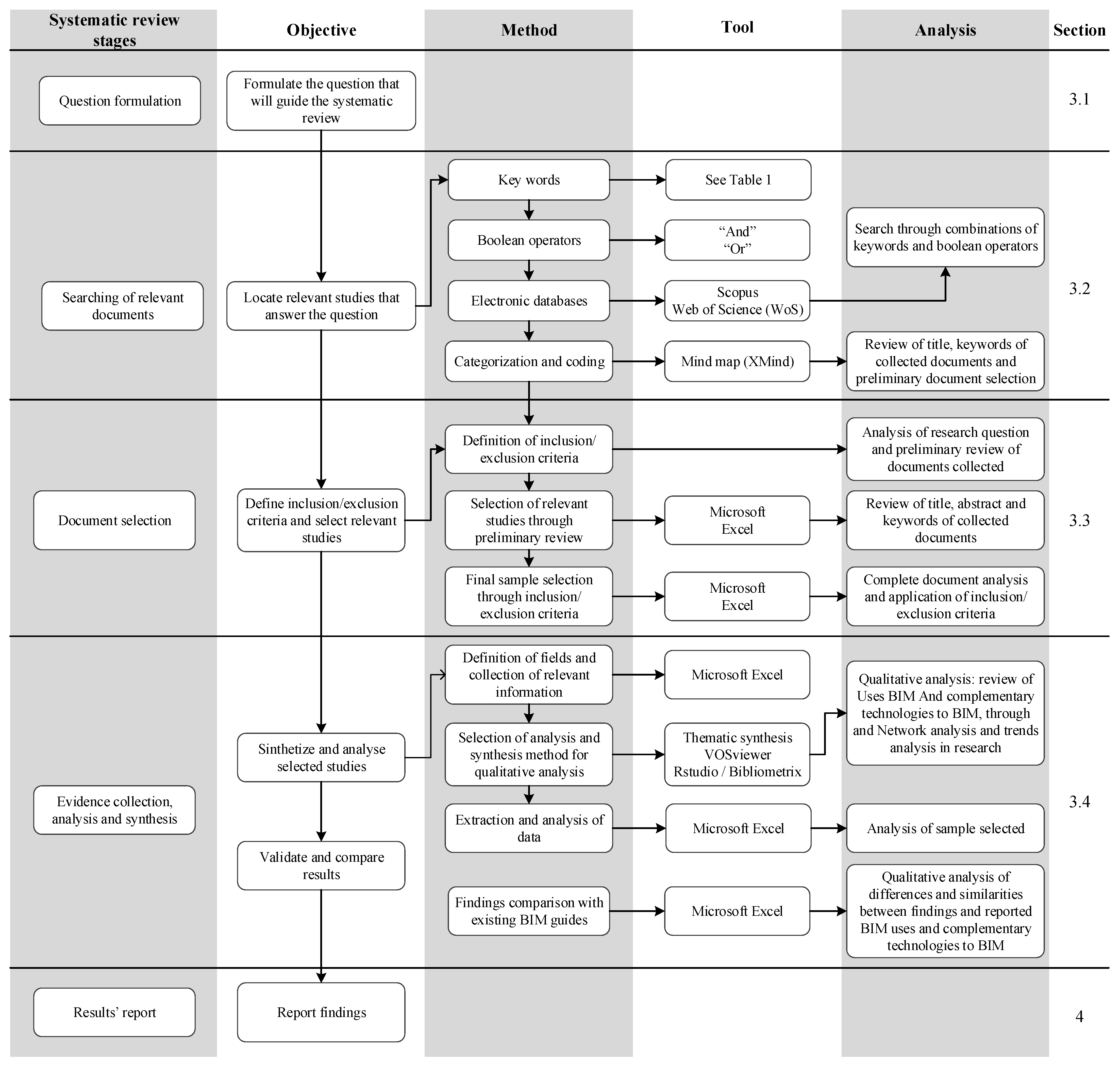
The diverse requirements of road projects have led to the development of various software tools to support the adoption of various BIM uses in road projects. Autodesk Civil 3D is a popular software that offers a range of powerful tools for road infrastructure design, including terrain modeling, road geometric design, and hydrologic analysis. This software helps create data-rich models that are crucial for informed decision-making in road projects and can support various stages of the road project lifecycle [40]. Autodesk InfraWorks is another tool that complements Civil 3D and is useful for modeling and digitizing road projects following the BIM methodology. InfraWorks is known for its ability to create realistic 3D visualizations and preliminary analysis of road projects. It integrates tools for traffic analysis, hydrological analysis, optimization of geometric design, preliminary analysis of bridges, environmental assessment and impact analysis, and quantity estimation, among others [41]. Bentley Systems provides OpenRoads, a comprehensive solution that enables modeling, simulation, and analysis of roads and highways. OpenRoads offers advanced functionalities for road design and integrates aspects such as traffic analysis and environmental assessments, making it ideal for complex projects [42]. PTV Group’s VISSIM is widely used for traffic simulation, providing detailed analysis of traffic behavior under varying conditions, which is essential for the design and planning of complex road projects [43]. In addition to these packages, other tools are emerging to meet the needs of road projects, such as Tekla [44], Vectorworks Landmark [45], Allplan Engineering Civil [46], and RoadEng Civil Engineer [47], among others.

3. Research Method

A systematic review is a rigorous, scientific, and transparent process [48] that aims to provide current knowledge on a specific research question or topic. The process involves a comprehensive literature review of various documents, enabling the reviewer to identify what is known and what is not known on the topic [49]. The key difference between a systematic review and a traditional literature review is that the former follows an explicit method for collecting and analyzing evidence, which allows for a thorough evaluation of the findings. This research study can be classified as a systematic review as it adheres to the four core principles proposed by Briner and Denyer [49]: (1) it uses a systematic method to address a research question, (2) the research method is explicit, (3) it is replicable and updatable, and (4) it provides a summary and synthesis of the evidence.

3.1. Systematic Review Stages and Research Questions

This research adopted a systematic review based on the stages outlined by Briner and Denyer [49], Saieg et al. [50], and Costin et al. [9] following the methodological recommendations proposed by the Joanna Briggs Institute (JBI) as presented by Lockwood et al. [51]. These references provided a comprehensive framework that ensured a methodical and rigorous examination of the available literature related to the research topic, which was aligned with the principles of the Preferred Reporting Items for Systematic Reviews and Meta-Analyses (PRISMA) method [51,52,53]. By adhering to these established protocols, the authors aimed to ensure transparency, consistency, and reliability in the review process. This approach facilitated the systematic identification, evaluation, and synthesis of pertinent studies, enhancing the validity and comprehensiveness of the findings. Following these guides and references, five stages were established: (1) question formulation, (2) searching of relevant documents, (3) document selection, (4) evidence collection, analysis, and synthesis, and (5) results report (see Figure 1). The five stages address the following research questions:
  • Research question 1: What are the BIM Uses that contribute to the activities of the life cycle stages of road projects?
  • Research question 2: What are the technologies that have been applied in conjunction with BIM methodologies on road projects?
  • Research question 3: How has the evolution and interrelationship of BIM and complementary technologies in road projects been developing?

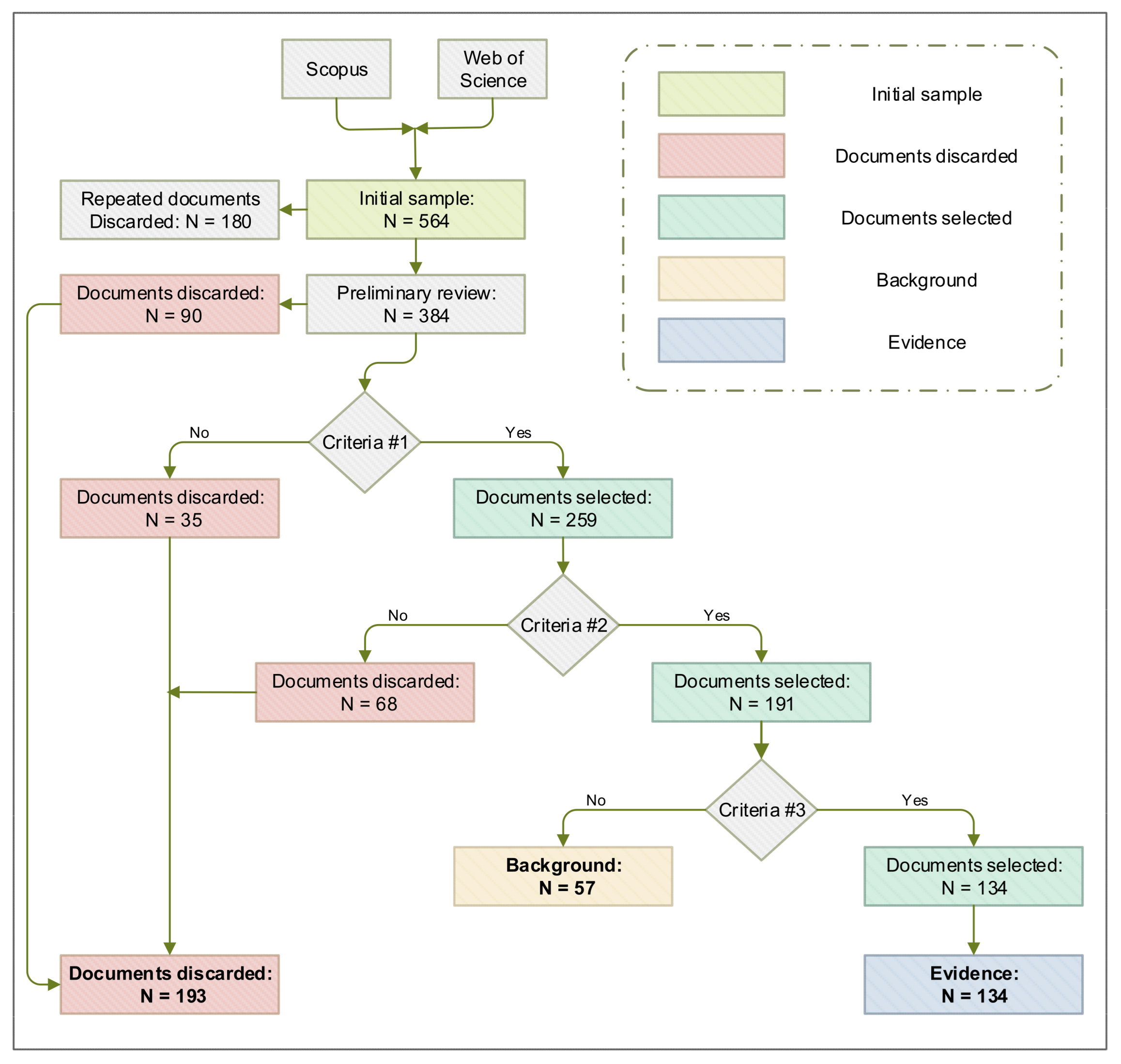
3.2. Searching for Relevant Documents

The first step in the search process involved defining keywords, Boolean operators, and search equations. Keywords were selected based on an analysis of research questions and a preliminary literature review. Search equations were created using combinations of keywords and the Boolean operators “AND” and “OR” (see Table 1). The search was conducted on search engines such as Scopus and Web of Science (WoS), which have electronic databases like the American Society of Civil Engineers (ASCE), ELSEVIER, Emerald Insight, Springer, and Taylor & Francis Group, amongst others. Google Scholar was used specifically to search for technical reports and BIM implementation guidelines that contained information on BIM use in construction projects, which were later compared. Out of 564 documents, 384 were selected after a preliminary review that considered title, keywords, and abstract. These selected documents were then encoded and categorized using a mind map with the help of XMind software (Version: 2020).

3.3. Document Selection

The document selection was made through the application of three inclusion/exclusion criteria: (1) the document focuses on BIM or CIM, (2) the document focuses on road projects, and (3) the document reports BIM Uses in road projects. In addition, the authors discarded work that focused exclusively on bridges, tunnels, or other structures specific to road infrastructure projects. This decision was based on the existence of previous studies that have already addressed these structures independently, and their inclusion in our analysis would have diverted the focus of this study beyond its intended scope. However, papers that addressed bridges, tunnels, or other structures within the broader context of highway projects were considered valuable and relevant. Thus, studies that presented these structures as integrated and complementary components of larger road infrastructure projects were included, ensuring that the results of this study maintained a consistent and focused approach to the analysis of road projects. A table was created in Microsoft Excel to collect information on each document’s code, title, authors, database, publication year, project type, and compliance with the inclusion/exclusion criteria. The criteria were assessed by reading the title, abstract, keywords, and conclusions, followed by a general review. If the document met the inclusion/exclusion criteria, it was marked as “Yes”, but if it did not, it was marked as “No”. The documents that met the three criteria were classified as “evidence,” while those that met criteria 1 and 2 but failed to meet criterion 3 were classified as “background” (see Figure 2).

3.4. Evidence Collection, Analysis, and Synthesis

This study collected data by reviewing 134 pre-selected documents. The data were extracted and organized in a table specifically designed for the document selection stage using Microsoft Excel. The table had fields for BIM Uses and complementary technologies relevant to its implementation. The review team, consisting of four experts, compiled and systematized the BIM Uses and complementary technologies mentioned by the authors and practically implemented them in their research. The experts identified the BIM Uses and complementary tools cited in each study, resulting in the identification of 45 BIM Uses and 35 complementary technologies. The BIM Uses were categorized according to their names and definitions. Then, each expert grouped the uses individually, which were later collectively discussed in a panel among the experts who participated in the evidence collection. Through a comparison of the results obtained individually by each expert, a consensus was reached in cases where the initial classifications differed, culminating in the final definition of 39 BIM Uses and 26 complementary technologies.
From the evidence collected, a network and thematic map analysis was conducted to analyze the relationship and development of BIM Uses. The aim was to identify emerging, current, and future uses that can guide new research directions in road project development. Advanced analytical tools such as VOSviewer and Bibliometrix were utilized to achieve this. These tools facilitated the identification of the most commonly applied BIM Uses to date, the existing interconnections between them, and emerging research trends. In VOSviewer, an analysis of the frequency of co-occurrence of BIM Uses was performed, which was complemented by a thematic map analysis in Bibliometrix and an analysis of the cumulative frequency over time of each BIM Use, which was prepared following the methodology presented by Castañeda et al. [54] and Lozano et al. [55]. This analytical approach provided a clear view of the BIM Uses that form the current basis of BIM implementation, and those that represent the future of innovative BIM practices applied to road projects.
The thematic analysis was carried out to explore the role of BIM Uses in the field of knowledge and its adoption in road infrastructure projects. Thematic map analysis is an essential tool for identifying the structure and evolution of a research topic of interest from specialized literature. Its usefulness lies in its ability to classify and visualize research trends and practices based on the importance and degree of development of each specific topic. In each of the quadrants, concepts are organized into clusters that indicate their relevance and conceptual maturity. Each cluster is generated from a co-occurrence analysis, highlighting the frequency and context in which the topics are discussed. The horizontal axis (x-axis) measures centrality, reflecting the relevance and influence of a concept within the knowledge network. In contrast, the vertical axis (y-axis) represents the “Developmental Score”, indicating whether a topic is rising or falling in the current context. This thematic map is, therefore, an invaluable tool for guiding future research and strategic decisions on a topic of interest. In this study, from the thematic analysis, it was possible to identify four main groups of BIM Uses that were classified into four main groups: Motor Themes, Niche Themes, Basic Themes, and Emerging or Declining Themes.
Finally, from the evidence collected, a comparative analysis was conducted between the BIM Uses identified in road infrastructure projects and those reported in construction projects. Key documents such as the BIM Guidelines of New York City [27], the BIM Guidelines for Vertical and Horizontal Construction [29], the work of Succar [28], and the BIM Project Execution Planning Guide [25] were examined for this comparison. The BIM Uses were qualitatively compared based on their names and definitions. This analysis helped to identify specific BIM Uses that have been developed to address the unique challenges and characteristics of road infrastructure projects. Among the BIM Uses identified, a set of applications specific to road projects stood out, which have not been reported in the context of buildings. Thus, the findings suggest that road projects require specific BIM tools and applications that align with the design, construction, and operation processes of this type of project.

4. Results

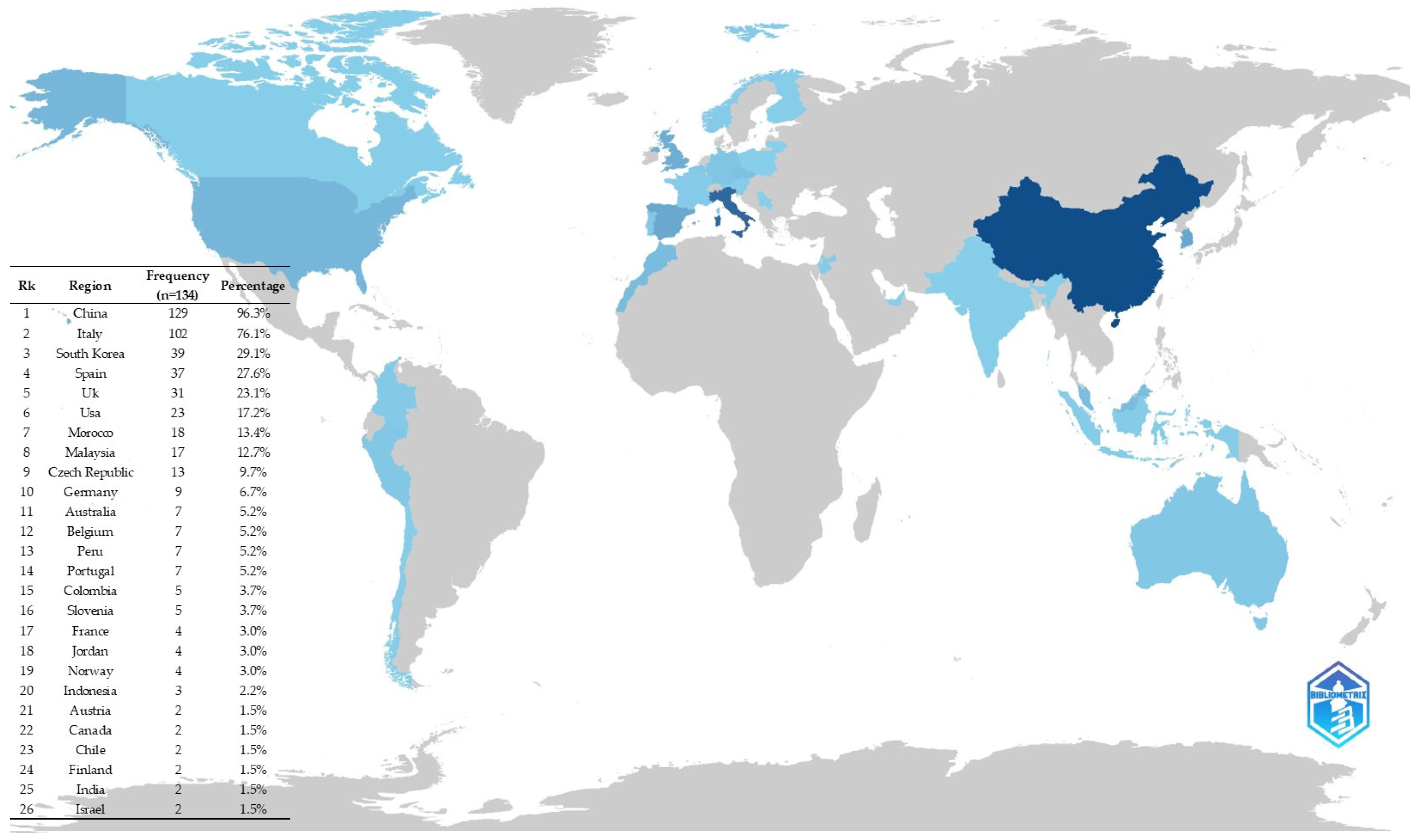
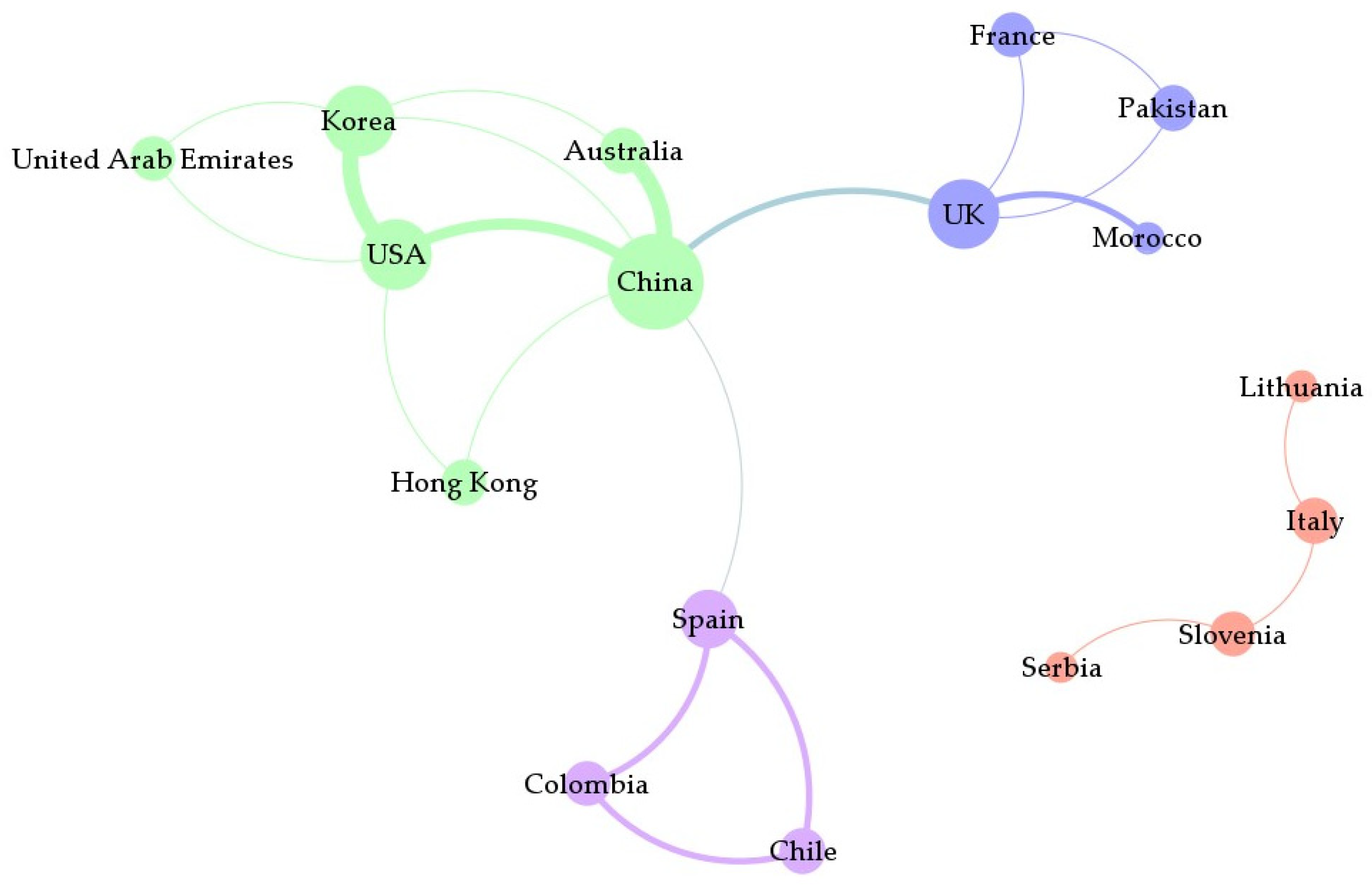
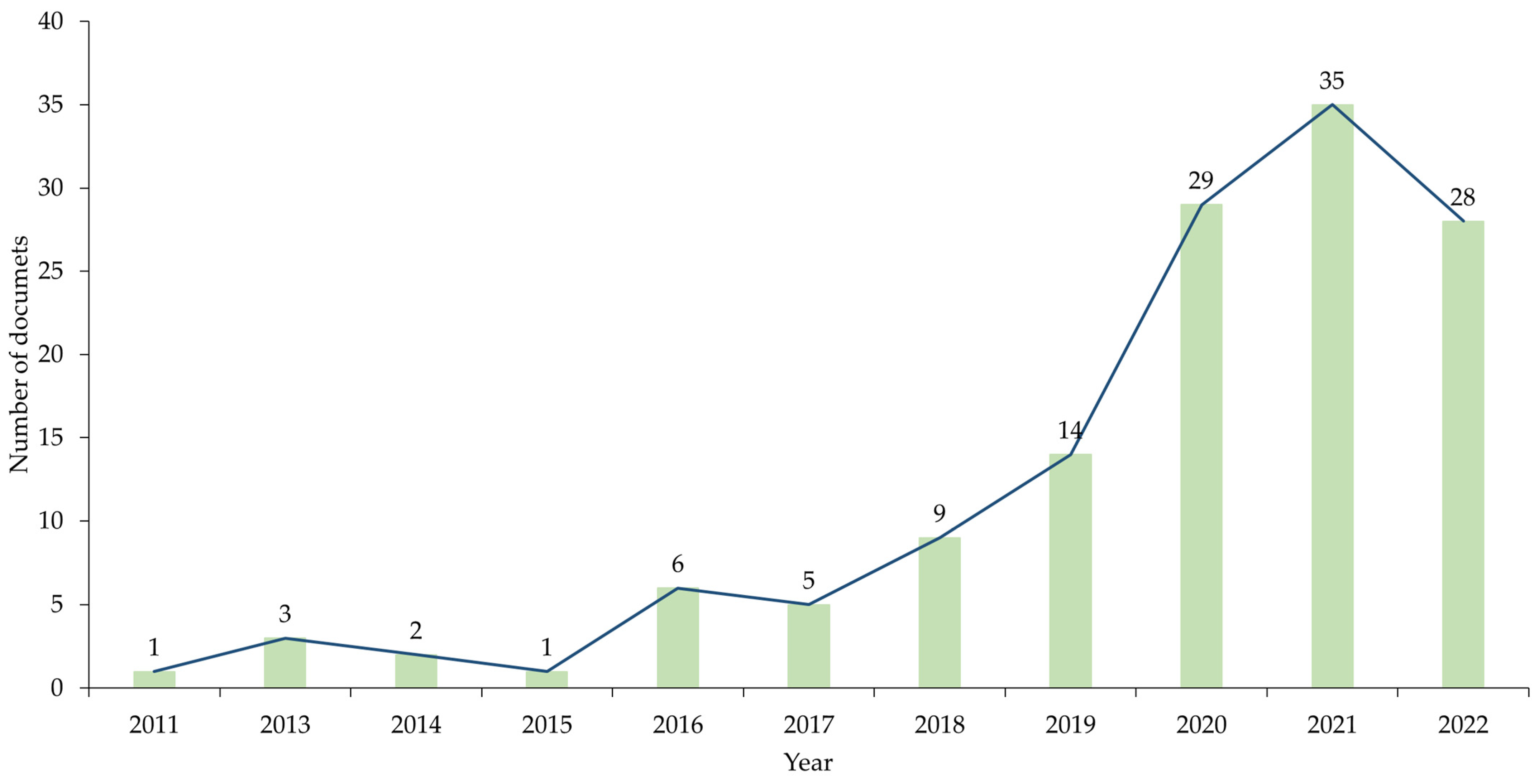
4.1. BIM Roads: Scientific Production by Country

The analysis of 134 studies shows that authors from nations with advanced economies are heavily represented in research on the implementation of BIM in road infrastructure projects. The countries with the highest participation in this field are China (n = 129; 96.3%), Italy (n = 102; 76.1%), South Korea (n = 39; 29.1%), Spain (n = 37; 27.6%), and the United Kingdom (n = 31; 23.1%), as shown in Figure 3. These nations not only have high gross domestic product (GDP) but also rank high in the World Economic Forum’s global competitiveness indices. Implementing BIM in road projects enhances efficiency and reduces risk throughout the project life cycle, which is especially relevant considering the significant environmental, economic, and social impact of road infrastructure and the large financial investments involved. The increasing number of annual publications on this topic indicates that the integration of BIM in road infrastructure projects is an expanding area of scientific research characterized by a recent and moderate volume of academic production.
Figure 4 shows the global collaborative networks that exist in the field of scientific research regarding the use of BIM in road infrastructure projects. There are four main networks, with the most productive one consisting of authors from China, South Korea, the United States, and the United Arab Emirates. Another network comprises academics from the United Kingdom, France, Morocco, and Pakistan. A third network brings together authors from various European countries such as Italy, Serbia, Slovenia, and Lithuania, while the fourth includes Spanish-speaking countries, namely Chile, Colombia, and Spain (see Figure 5). This diverse mix of cultures in BIM research for road infrastructure provides an in-depth analysis, offering different perspectives on the potential, advantages, and challenges of implementing new technologies in linear projects, thus promoting a more comprehensive understanding. However, it is worth noting that there is a significant under-representation of authors from certain regions of Africa and Latin America, which may suggest a lower level of BIM adoption in road projects in these areas.

4.2. BIM Uses for Road Projects

From the review of 134 selected documents in the “evidence” category, 39 BIM Uses in road projects were identified. The collected data were grouped into nine categories according to the characteristics and functions in the project life cycle. Table 2 illustrates the frequency of BIM Uses that have been implemented in road infrastructure projects, as reported in the literature. It is interesting to note that the top five most commonly reported uses in the studies analyzed are (1) 3D modeling of existing conditions (U1) (n = 65), (2) quantity take-off and cost estimation (U37) (n = 43), (3) geometric design (U7) (n = 34), (4) maintenance plan (U34) (n = 4), and (5) clash analysis (U3) (n = 5). It is worth mentioning that many of these frequent uses in road projects are also prevalent in building projects, suggesting that methodologies initially developed for building projects could be adapted to address various issues that persist in road infrastructure projects over time.

4.2.1. Road Design

Designing roads is a complex task that involves numerous stakeholders, processes, and information exchanges [4,56]. Designers must also consider mathematical equations, design criteria, and codes when determining road parameters such as speeds, lengths, radii, and slopes [13]. The use of Building Information Modeling (BIM) in road design can help reduce complexity and automate the design process by parameterizing road elements in the BIM model. When a unit is modified, adjacent units automatically update, and design criteria and codes are automatically verified [57]. BIM functions such as visualization, simulation, coordination, optimization, and graphic representation can improve the evaluation of design alternatives, road design optimization, detection and resolution of design errors and inconsistencies, design documentation, prefabricated use, and other related aspects (see Table 3).

4.2.2. Traffic Analysis

The traffic of vehicles, pedestrians, and cyclists influences the life cycle stages of road projects. This makes it necessary to conduct traffic studies that are aligned with specific project requirements and scenarios [2,22]. The use of the traffic analysis category in BIM (see Table 4) allows for the BIM model to be used as a traffic simulation platform for various purposes and parameters. With this approach, the traditional traffic analysis model is replaced by a set of processes where the traffic data are integrated into the BIM model to evaluate and analyze design alternatives, road configurations, traffic management options, and other factors.

4.2.3. Soil Aspects

Large areas of land are required for road projects, which often involve changes in geotechnical and geological conditions [17]. Additionally, the design of the road results in a variety of earthworks that require significant effort to estimate [2]. The use of BIM in soil aspects (see Table 5) takes advantage of the vast amount of information integrated into the BIM model, as well as the automated functions for calculating and obtaining sections and elevations of the elements in the model (including terrain). The versatility provided by BIM enables the integration of specialized packages for soil analysis and the integration of Geographic Information Systems (GISs) for geospatial information analysis in conjunction with the information stored in the BIM model.

4.2.4. Road Safety

Road construction projects pose high risks to people’s safety. During the construction stage, personnel, users of adjacent roads, and other stakeholders may be exposed to safety hazards generated by construction activities [58]. In the road operation stage, the safety of pedestrians, drivers, and other users can be compromised by various factors [59,60]. BIM can be used to enhance road safety (see Table 6) by adopting the BIM model to view, simulate, analyze, prevent, and resolve potential safety risks in all stages of the road life cycle.

4.2.5. Environmental Issues

Road construction projects have a significant impact on the environment as they require a considerable amount of natural resources and large areas of land for construction and operation [22]. Therefore, there is a constant need to find sustainable and efficient solutions [61]. Additionally, human activities have caused damage to the environment, creating a demand for sustainable projects. To address this, emerging BIM Uses (see Table 7) aim to reduce energy consumption, project costs, construction timelines, CO2 emissions, and the negative impacts on natural resources, animal habitats, ecosystems, and water sources, among others [62,63].

4.2.6. Other Engineering Analysis Methods

Road projects involve multiple elements that require analysis from professionals with different knowledge and experiences. Each discipline has its methods, requirements, and contributions that must be integrated into the project to ensure consistency and compatibility with other project elements. This has remained a continuous challenge for project managers and participants [56]. To meet these specific needs, several BIM Uses have been created and improved, seeking coordination, collaboration, integration, and compatibility with other project parts [9,64]. BIM Uses are supported by automated processes and computational algorithms that simplify and speed up the evaluation of different scenarios, increase exploration of design alternatives, and improve decision-making processes (see Table 8). The BIM Use pavement analysis (U22) has significantly progressed, especially in heritage preservation as seen in Pompeii, where Heritage BIM has improved the management and restoration of roads [65]. With the help of tools such as laser scans and digital models, accurate, geo-referenced representations are now possible [66]. Moreover, visual programming in Python streamlines data management. In asphalt pavements, BIM supports sustainable design selection and maintenance analysis, leading to informed decisions and a circular economy in the road industry [67]. This progress highlights the transformative impact of BIM toward more efficient practices in road engineering.

4.2.7. Construction Planning and Analysis

Detailed planning is crucial in the construction and maintenance of road projects due to the large amount of human, material, and equipment resources involved [68]. Efficient on-site activities can be compromised by unwanted phenomena such as delays, cost overruns, storage problems, non-useful movements, shortage of resources, inappropriate resources, and quality problems [69,70] (see Table 9). BIM models and simulations can be used to improve planning activities, such as exploring different options to select alternatives with greater efficiency and convenience. In the pre-construction stages, considerable time and effort are invested in analyzing and planning the construction process [71], which is motivated by the project extension and the level of detail required. Adequate analysis allows for the identification, characterization, and management of errors, restrictions, and aspects related to the impact of construction activities on the environment [72]. BIM can significantly improve these analyses by simulating processes in virtual environments, thereby allowing the exploration of various scenarios without jeopardizing economic resources or human lives. Combined with process automation and stakeholder collaboration, this leads to the optimization of and improvement in planned construction activities [73].

4.2.8. Cost Analysis

During the various stages of a road project’s life cycle [4], multiple analyses need to be conducted in order to manage costs effectively. To do so, detailed estimates of quantities and unit prices are required. The BIM methodology can be used as a cost analysis platform (see Table 10). BIM can help with detailed quantity take-offs and cost estimations (U37) of project elements [74]. It can also aid in analyzing cash flows during the planned construction process through the adoption of digital simulation BIM 5D [75].

4.2.9. Construction Monitoring and Control

Effective monitoring and control of construction activities are crucial for the success of the construction stage. Traditionally, on-site inspection and comparison with the project plan are used to measure construction progress, but these processes are often slow, expensive, and prone to human error [76]. However, BIM can be used to integrate the monitoring and control activities (see Table 11). To improve the acquisition and updating of site information, BIM can be complemented with various technologies such as laser scanning, photogrammetry, drones, sensors, etc. [9,77,78,79].

4.3. Relationship and Evolution of BIM Uses in Road Projects

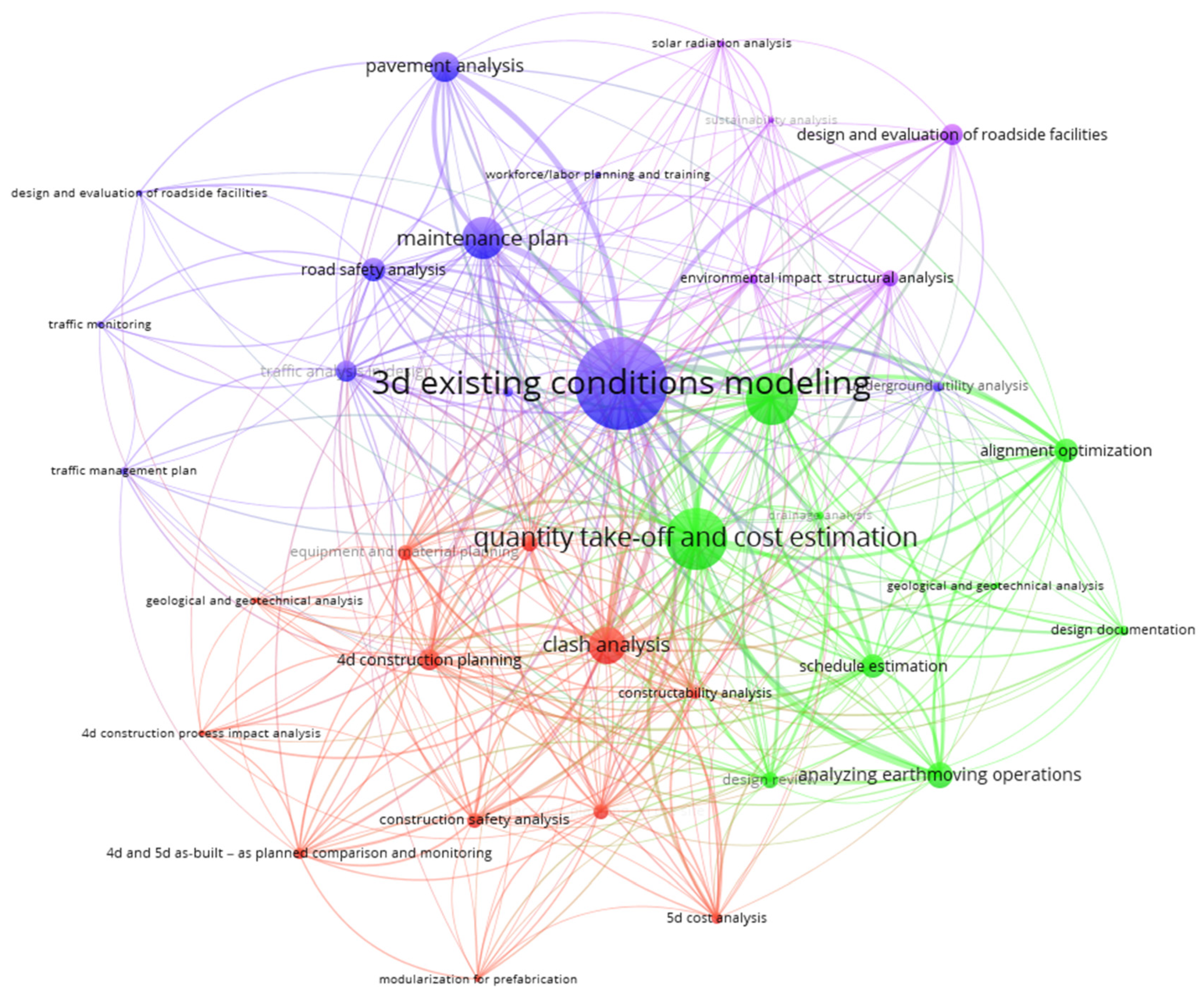
4.3.1. Relationship between BIM Uses in Road Projects

This study used co-occurrence analysis, a network analysis technique, to examine the relationship between key topics in a specific research corpus [80,81]. The objective was to understand the structure and relational dynamics in research on the application of BIM Uses in road infrastructure projects. The analysis identified the BIM Uses that are most commonly used in the development of highway projects. A map of the relationships between the BIM Uses identified in the sample of 134 documents analyzed is shown in Figure 6. Each node in the map represents a particular BIM Use, with the size of the node corresponding to its frequency of mention in the literature. The connections between nodes indicate the co-occurrence of BIM Uses in the same research, making it possible to identify their conceptual and contextual links. This analysis provides a unique perspective on the convergence of topics, highlighting areas of intense research and possible synergies, which is crucial for a better understanding of BIM integration in highway engineering [81].
Figure 7 displays the core uses of BIM in road projects. The review of classified documents revealed that the most prominent uses of BIM in such projects are (1) 3D existing conditions modeling (U1), (2) quantity take-off and cost estimation (U37), (3) tracking onsite construction progress (U39), and (4) design and evaluation of roadside facilities (U4). These are considered vital starting points for the effective management of various processes in roadside project management. They form the basis for expanding into more advanced BIM applications that encompass the entire roadway project life cycle. The interconnections between these BIM applications highlight synergies that can improve their joint application, providing better efficiency, safety, and project management support. Therefore, there is a growing interest in exploring how various BIM applications can be combined to address the challenges inherent in road infrastructure projects comprehensively.
The BIM Use of 3D existing conditions modeling (U1) has established itself as a crucial component in the management of road infrastructure projects, as accuracy in the initial phases is critical to the effectiveness and success of subsequent stages of the project [82]. This technique provides a detailed starting point for capturing data from the real environment, which is essential in the creation of accurate and efficient geometric designs [83]. When combined with strategies such as the maintenance plan (U34), it improves the ability to anticipate and prevent future failures, promoting continuous and effective maintenance [84,85]. In terms of traffic management plan (U9) and traffic monitoring (U10) uses, 3D models contribute to more accurate planning and agile management of traffic flow variations [86]. Both drainage analysis (U21) and pavement analysis (U22) are enriched by the use of 3D models, allowing professionals to simulate scenarios and forecast the impact of current conditions on the infrastructure [87,88]. Additionally, underground utility analysis (U26) mapping gains in accuracy with these models, reducing the risks associated with subway works [1,89]. The integration of 3D existing conditions modeling with other BIM Uses reinforces its role as a central information hub, facilitating the coordination and optimization of all stages of the road project life cycle [89].
Quantity take-off and cost estimation (U37) are crucial aspects of BIM that play a central role in the economic feasibility and decision-making process of road infrastructure projects [90,91]. These practices are closely linked to 3D existing conditions modeling (U1), which provides an accurate digital representation of the existing context, allowing for precise resource estimation. Accurately assessing the volumes of materials required is essential for professionals who use detailed knowledge of the terrain and existing buildings to make informed decisions. Quantity take-off and cost estimation (U37) are intertwined with alignment optimization (U2) and schedule estimation (U35), as any modifications to the design can have a significant impact on resource allocation, schedules, budget, and economics of the project [90,92]. This interrelationship is crucial for effectively coordinating the design, construction, and operation phases, allowing for timely adjustments and fine-tuned financial management [93]. The BIM Uses 5D cost analysis (U36) and 4D construction planning (U32) deepen cost estimation by integrating time and financial aspects into the BIM model, providing an extended perspective of the economic impact throughout the project cycle. Together, quantity take-off and cost estimation (U37) form the backbone of a system of interconnected BIM practices, each reinforcing the others—all of which are indispensable for the economic management of highway projects [94,95].
Tracking onsite construction progress (U39) has become an essential use of BIM technology for efficient and up-to-date construction monitoring [96]. Its integration with clash analysis (U3) is particularly significant, as it allows for the identification and resolution of discrepancies in the virtual model, which helps prevent cost overruns and delays in the construction process [16]. This constant monitoring also enhances construction safety analysis (U14), facilitating the early detection and mitigation of risks on the job site, which is crucial for employee safety and regulatory compliance [97]. Moreover, 4D construction planning (U32) leverages monitoring data to refine scheduling and task sequencing, contributing to more strategic time management and reducing conflicts in the execution of activities. The BIM Use 4D construction process impact analysis (U31) uses the gathered information to assess the impact of schedule variations on project objectives, supporting more informed and flexible management [98]. Overall, the synergy between these BIM Uses underscores the importance of taking an integrated approach to road project management, where cost clarity, schedule coordination, and conflict anticipation come together to sharpen project performance and budget efficiency [99].
The use of BIM in the design and evaluation of roadside facilities and structural analysis is vital for the development of road infrastructure engineering. By combining the aesthetics and functionality of roadside facilities with rigorous structural analysis provided by BIM, projects can be designed to blend harmoniously into their visual and operational context while meeting structural integrity criteria for longevity and safety [86,100,101]. BIM provides a solid foundation for assessing the ability of facilities to withstand loads and impacts throughout their service life. This approach ensures that the beauty of road infrastructure projects goes hand in hand with their strength, safety, and durability [8]. Road safety analysis (U17) is directly intertwined with this approach, as the proper design of roadside facilities is crucial to protect road users and reduce accidents [99,102]. The design evaluation of roadside facilities aligns closely with the environmental impact in road infrastructure planning [103,104]. It establishes a fundamental relationship for responsible and sustainable projects. The evaluation process not only focuses on the functionality and visual integration of these facilities but also incorporates analysis of their environmental impact. BIM enables the ecological consequences of facilities to be modeled and predicted from the conceptualization phase through implementation. This integration of environmental impact underscores the importance of conscious design. It promotes the creation of road facilities that respect the surrounding ecosystem, underlining the commitment to sustainability in the field of road construction [105].
Each link between the uses of BIM represents more than just a connection between two practices. It is a synapse within an active organism of project management, where information flow and decisions are optimized to enhance the quality, efficiency, and performance of highway projects. The distinction between certain uses and others reflects both the frequency of their application and their impact on professional practice. This provides a roadmap for future research and development within the construction field.

4.3.2. Thematic Map of BIM Uses in Road Projects

The thematic map analysis in the context of scientific literature is a visualization tool that classifies concepts based on a two-dimensional plane: centrality (importance) and their degree of development in the current context (development degree). This map divides concepts into four main quadrants (see Figure 8). Motor Themes, located in the upper right quadrant, are highly relevant and have a high degree of development. They represent the concepts and practices that currently dominate the field of study and are considered mature and essential to the discipline. Niche Themes, located in the upper left quadrant, contain equally highly developed concepts but with low importance in the discussion of the current context. This suggests that, although important, their application may be more specialized or limited to specific contexts within the field. Basic Themes, located in the lower right quadrant, represent the fundamental concepts as part of the development of the field, thus contemplating the established constructive knowledge upon which other themes and practices are developed. Finally, Emerging or Declining Themes, found in the lower left quadrant, have less development and relevance in the current context. They may be recent innovations that have not yet gained traction or practices that are being replaced by new trends and technologies. From the thematic map analysis, it is possible to establish how different concepts relate to each other within the broader spectrum of the field of study, thus identifying key areas for future research [54,55,106].
The thematic map provides a qualitative perspective by placing BIM Uses in the context of relevance and conceptual development. The correlation between the high frequency of occurrence (see Figure 6) and the centrality in the thematic map (see Figure 8) highlights the importance and maturity of BIM Uses in professional practice. Meanwhile, emerging uses like tracking onsite construction progress (U39) are less frequent in the literature but indicate a growing area of interest and innovation. By integrating these analyses, scholars and practitioners can understand which BIM Uses are prevalent, how they are interrelated, and how they evolve within the BIM research and practice framework. The Motor Themes quadrant contains several useful BIM Uses, such as quantity take-off and cost estimation (U37), clash analysis (U3), 4D construction planning (U32), design review (U6), structural analysis (U24), construction safety analysis (U14), equipment and material planning (U28), and space use planning on the site (U29). These uses are highly relevant and mature in the field of BIM, indicating that they are areas of consolidated focus and standard practice in BIM road projects [86]. They are central and dominant in the current literature, reflecting their status as well-established practices that drive adoption and innovation in BIM. Their proximity and grouping suggest a functional interdependence, where accuracy in cost estimation is complemented by proactive interference analysis and detailed planning of materials, equipment, and temporary facilities required in the construction processes of road infrastructure projects [86,107,108].
Niche Themes consist of BIM Uses related to the design and evaluation of roadside facilities (U4), traffic management plan (U9), traffic monitoring (U10), traffic analysis in design (U11), vulnerability analysis (U27), drainage analysis (U21), and road lighting analysis. These represent specialized areas of BIM adoption in road projects that, while not universal in their application, are of critical importance in specific contexts. Their presence in this quadrant suggests that, although highly developed, their current practical relevance may be limited to specific applications or specialized contexts, indicating opportunities for further integration and exploration with other BIM Uses [9,109]. Basic Themes groups BIM Uses such as 3D existing conditions modeling (U1), geometric design (U7), maintenance plan (U34), analyzing earthmoving operations (U12), alignment optimization (U2), road safety analysis (U17), schedule estimation (U35), and design documentation (U5). Their position indicates that, although essential to the foundation of BIM projects, they may be subject to less recent conceptual and practical development. However, their central placement underscores their continued importance as pillars of BIM methodology in road projects.
Finally, the Emerging or Declining Themes quadrant, represented by tracking onsite construction progress (U39) and 4D and 5D as-built and as-planned comparison monitoring (U38), emerges as a significant practice in BIM use, which benefits real-time updates that facilitate more agile and accurate construction process management. Its increasing adoption promises tighter integration of information between the construction site and BIM models, potentially leading to more efficient project execution with adaptive planning. The way in which different BIM Uses interact with each other reflects the varying levels of adoption and development within the BIM field in relation to roadway projects. Over time, adjacent quadrants of BIM Uses may influence one another, resulting in a transition from one quadrant to another. Meanwhile, opposite quadrants may see a shift from established practices to new emerging trends or vice versa. This thematic mapping serves as a guide for a research and development strategy, highlighting areas that require attention and those that offer the most promising opportunities for innovation in BIM implementation.

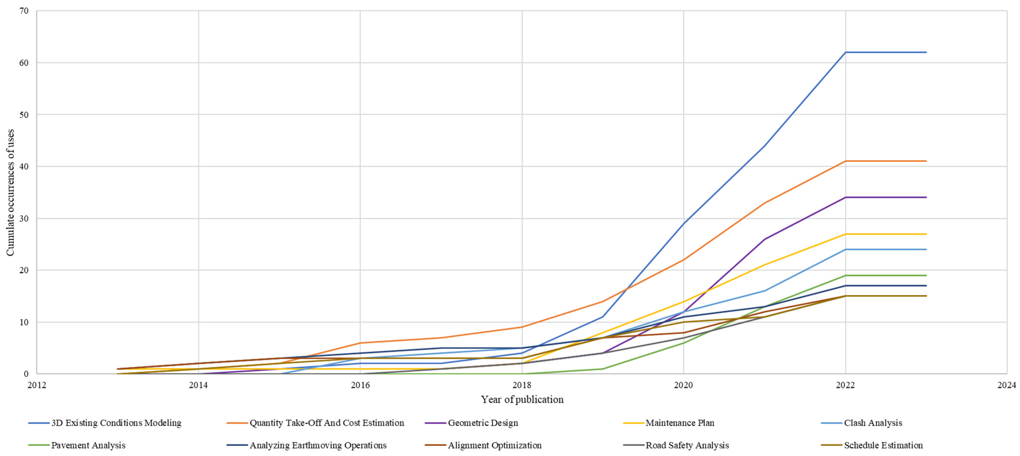
4.3.3. Evolution of BIM Uses in Road Projects

A trend analysis was performed to understand the evolution of BIM Uses in the development of highway projects. These analytical tools provide a dual perspective: quantifying the popularity of each use and its trajectory over time. Figure 6 presents the progressive adoption of BIM Uses in highway project development by cumulative frequency, which provides a longitudinal perspective, showing not only the current prevalence of BIM Uses but also how this prevalence has built and developed over time. In contrast, the trend graph plots the emergence and growth of or decline in these practices over time, providing a dynamic view of how BIM Uses have been adopted or abandoned in the specific context of road construction. It is noteworthy that most BIM Uses show a steady growth over time, which is evidence of an increase in the interest of practitioners and researchers in addressing the search for solutions to improve various problematic issues affecting road projects.
The BIM Uses and their representation in trending themes capture the progressive expansion and specialization of the field. Figure 9 indicates that essential uses such as 3D existing conditions modeling (U1), quantity take-off and cost estimation (U37), and geometric design (U7) have maintained a consistent presence, emphasizing their central roles in the planning, design, and construction of roadway projects. However, the emergence of topics such as pavement analysis (U22), alignment optimization (U2), road safety analysis (U17), and schedule estimation (U35) reflects a growing interest in optimizing infrastructure and road safety, as well as in the time and financial efficiency of projects.
The literature shows that there is a growing trend toward adopting the use of technology in the construction industry. This includes practices such as clash analysis (U3), maintenance plan (U34), and analyzing earthmoving operations (U12), which are aimed at preventing design errors, ensuring the long-term sustainability of infrastructure, and increasing operational efficiency at construction sites. In addition, 4D construction planning (U32) and 4D construction process impact analysis (U31) reveal an industry that is moving toward a deeper integration of technology to address the effects of construction activities on the environment and road users. This integration of established practices and innovative approaches highlights the evolution of BIM in its technical capabilities and its applicability to contemporary construction and environmental management challenges. Specifically, the focus on environmental impact (U18) and construction safety analysis (U14) highlights the multifaceted nature of the BIM Uses. The adoption of multiple BIM Uses together facilitates a more integrated approach to decision-making processes by analyzing various alternatives and incorporating a holistic perspective of the variables that impact road projects. This approach is key to developing effective solutions to the challenges that arise in the different stages of the life cycle of these projects, improving their efficiency and sustainability. In conclusion, the growing trend of adopting the use of technology in the construction industry will be critical to the advancement of road project development. The ability to adapt and anticipate the needs and impacts of these projects will be essential in meeting the challenges of the future.

4.4. Technologies Complementary to BIM in Road Projects

4.4.1. Frequency Analysis of Technologies Complementary to BIM in Road Projects

The combination of Industry 4.0 technologies and other innovative approaches with the BIM methodology is gaining significant attention in the different phases of road infrastructure projects [32]. After analyzing documents classified as relevant evidence, a number of technologies were identified that effectively complement the BIM Uses in these projects. Table 12 shows the technologies that most frequently appear in the documentary review. This indicates an increasing trend toward implementing advanced technological solutions in conjunction with the BIM methodology in the road infrastructure field. It is worth noting that the top five emerging technologies and methodologies are programming tools (T1) (n = 27), geographic information systems (T2) (n = 26), laser scanning (T3) (n = 18), drones (T4) (n = 15), and sensors (T5) (n = 14).
Table 12 shows a wide variety of technologies that, complementing BIM, enhance the effectiveness of road infrastructure projects. Programming tools (T1) are particularly useful for automating tasks and generating algorithms that optimize roadway design. Meanwhile, geographic information systems (GISs) (T2) are essential for integrating geospatial data, which is crucial for planning and environmental analysis. These tools are often mentioned in the literature because they increase accuracy and reduce time and costs [110]. Laser scanning (T3) technology provides measurements of distances and geometric features of terrain and infrastructure, capturing fine details that are integrated into the BIM model for an accurate representation of reality [111,112]. Drone (T4) technology, on the other hand, allows for the aerial capture of images and data in large or difficult-to-access areas, ensuring that the BIM model accurately reflects the actual context of the construction environment [113]. The increasing popularity of laser scanning (T3) and drones (T4) is a testament to their significant role in capturing highly detailed topographic data. This, in turn, leads to improved accuracy of BIM modeling.
The use of sensors (T5) also enhances collaboration and facilitates real-time data management by continuously providing large volumes of information from the construction site [114]. This allows for rapid, data-driven responses to changing conditions. Cloud computing (T6) is vital for efficient field coordination and execution, as it enables instant access and sharing of data and BIM models between geographically dispersed teams. It also allows for simultaneous collaboration, centralized storage, and scalable computing capacity, which are essential for addressing the complexity of modern highway projects [115]. The Internet of Things (IoT) (T8) can also be used in conjunction with sensors (T5) and cloud computing (T6) to optimize data collection and operational response. The IoT interconnects devices and sensors at the site, resulting in enhanced collaboration and real-time data management.
Photogrammetry (T7) plays a crucial role in the digital reconstruction of existing terrains and construction sites. It provides the possibility of converting images captured by either ground or aerial cameras into detailed 3D maps, which are highly accurate digital models [116]. These models are fundamental for the planning and analysis of road projects, enabling engineers and designers to assess pre-existing conditions, foresee potential problems before construction, and more. Artificial intelligence (AI) (T9) is a powerful tool that enables predictive analysis and data-driven decision-making. By processing large sets of historical and real-time data, AI can identify patterns, predict trends, and propose optimal solutions at all stages of the life cycle of road projects [117]. Its implementation can help in foreseeing construction problems, optimizing the use of resources, automating planning activities, improving monitoring and control processes, and more. AI’s application in traffic analysis, vehicular flow simulations, and environmental impact assessments would support road planning and design processes through the creation and analysis of future scenarios. With AI, contractors, consultants, and designers can create and analyze possible future scenarios, which would aid in planning and designing better road networks [118].
Web-based interfaces (T11) offer a convenient platform for project management, enabling seamless communication among teams. They prove useful in both the early stages and operation stages of a project, where diverse data need to be collected, processed, and analyzed. Smart cities (T10), as a complementary tool, can integrate various technological and operational data into a centralized and dynamic model. This model benefits the design, construction, and maintenance of roads. The tool is designed for the collection and analysis of large volumes of real-time data, such as traffic patterns, environmental conditions, and user behaviors [119]. It enables accurate planning and proactive management, aligning with the sustainability and efficiency goals of smart cities [55]. Furthermore, the interoperability of smart cities is essential for effective BIM integration, facilitating collaboration among various disciplines and stakeholders. This collaboration ensures that all aspects of the roadway project are synchronized and sustainable in the long term.
Emerging technologies like virtual reality (VR) (T14) and smart electronic devices (T13) are gaining traction in road planning and construction for their potential to improve project understanding, decision-making, efficiency, safety, and cost and schedule control [120,121]. VR offers a unique opportunity to immerse oneself in BIM models of road projects, allowing for better interaction and visualization in a controlled environment. On the other hand, smart electronic devices (T13) like cell phones, tablets, and interactive displays are being adopted to promote technological innovation and efficiency in construction management. The convergence of these technologies with BIM is becoming a driving force in the design and construction of road projects, and their differentiated recurrence in the literature signifies their direct impact on the industry.
In the AEC industry, BIM and its complementary technologies are intricately linked to the size and complexity of projects. Ali et al. [122] highlight the potential synergy between BIM and geographic information systems (GISs), emphasizing the need for their integration to provide comprehensive data for building projects and their surroundings. Kostesha et al. [123] emphasize the importance of geoinformation systems in managing the property complex of highways, highlighting their capabilities in processing, analyzing, and storing spatial and semantic data. The researchers argue that analyzing infrastructure characteristics in isolation is insufficient and advocates for a unified approach. Additionally, there is a growing interest in Internet of Things (IoT) solutions leveraging BIM platforms to offer a unified view of rich contextual infrastructure information and real-time sensory data, as noted by Ali et al. [122]. Moreover, Nguyen et al. [124] discuss the role of 3D laser scanners in creating spatially detailed point clouds for complex projects, enabling the construction of intricate geometric BIM models. Xu et al. [125] stress the complexity of highway projects in hilly areas, prompting the integration of BIM and virtual reality (VR) technology. The integration aims to create an interactive decision support platform for temporary facility layout planning on road construction sites, facilitating precise, visualized decision-making and enhancing the efficiency of construction site layout planning in complex terrains. The diverse technological integrations showcased in these studies underscore the pivotal role of BIM and its associated technologies in addressing the unique challenges posed by the size and complexity of engineering projects.

4.4.2. Relationship between Technologies 4.0 Complementary to BIM in Road Projects

A network analysis was conducted to analyze the co-occurrence of emerging technologies and approaches that are used along with BIM in road projects. The main objective was to understand the structure and connections between the research on complementary technologies and the implementation of BIM in road projects. The analysis was based on a sample of 134 documents, and the relationships identified are presented in Figure 10. Each node in the figure represents a complementary tool to BIM, and the size of the node is proportionally related to the frequency of its use. The connections between the nodes show the links between the tools, highlighting their synergy and practical relevance [54,55]. Figure 10 displays the main technologies used in road infrastructure projects and their interrelationship based on the frequency of co-occurrence observed during the documentary review. The review identified three main groups of relevant tools associated with BIM implementation. The following technologies represent these groups: (1) programming tools (T1) (red color), (2) laser scanning (T3) (green color), and (3) sensors (T5) (blue color). The results of the analysis demonstrate the interdependence of complementary technologies in the field of BIM and reveal a trend toward deeper and more collaborative integration in the development of road projects. In addition, the co-occurrence networks depicted in the diagram indicate that the field is in constant evolution, and the interplay between different tools drives innovation and optimization in the design and construction of road projects.
The first group of tools can be divided into two categories: programming tools (T1) and geographic information systems (GISs) (T2). These tools are closely related to each other, as well as to other tools like smart cities (T10), Semantic Web (T26), and photogrammetry (T7). Together, they form a complex network of technological applications that enhance the functionality of BIM for road infrastructure projects. Smart cities (T10) technology enables the programming tools (T7) to manage and analyze large volumes of urban data, which is crucial for intelligent and sustainable road design [126]. The connection with the Semantic Web allows GIS technology to benefit from richer and more connected data structures, thereby improving the semantics and accessibility of geospatial information. Photogrammetry (T7) aligns with the accuracy of GIS technology and the flexibility of programming tools (T7) to provide detailed and accurate terrain reconstructions, which facilitates planning and topographic analysis within the BIM environment. These synergies demonstrate the potential of these tools to revolutionize the planning, execution, and management of road infrastructure in the context of increasingly smart and connected cities.
Laser scanning (T3) is a crucial technology in the BIM ecosystem in the second group, as it is connected to other technologies such as drones (T4), ground-penetrating radar (T24), and 3D printing (T20). When combined with drones (T4), laser scanning (T3) can provide topographic data from aerial perspectives, which improves the accuracy of the BIM model. Ground-penetrating radar (T24) complements laser scanning (T3) by detecting subway features that are vital for comprehensive road infrastructure planning [127]. 3D printing (T20) leverages the detailed data provided by laser scanning (T3) to create physical scale models and components for physical simulations and design validations, which facilitates a more iterative and accurate design and construction process. In the third group, sensors (T5) play a crucial role in the Internet of Things (IoT) (T8), virtual reality (VR) (T14), and augmented reality (AR) (T16). They collect operational data, which are fed into the IoT systems, while VR and AR provide platforms to visualize and interact with BIM models [128,129,130]. These tools improve project understanding and decision-making processes. This integration of technology and collaboration in road projects is empowering BIM implementation with a suite of advanced complementary tools.

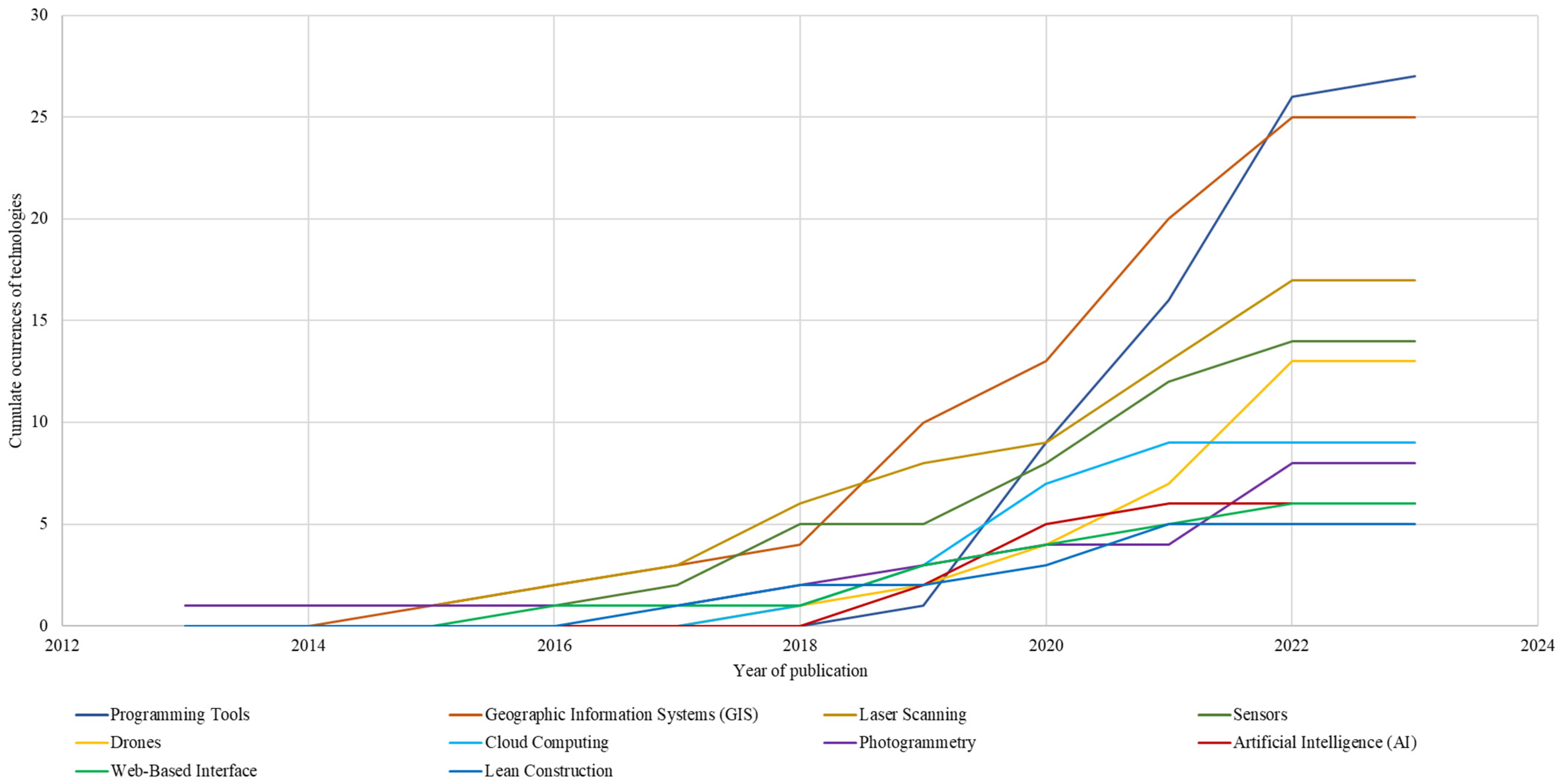
4.4.3. Evolution of Technologies 4.0 Complementary to BIM in Road Projects

Figure 11 presents a timeline of the adoption and trends of complementary tools to BIM in road infrastructure projects. The analysis tracks the development and evolution of these tools and their frequency of mention in documents from 2012 to 2022. This provides a clear understanding of the adoption dynamics of the primary tools used in conjunction with BIM. This study highlights the increasing importance of emerging technologies like artificial intelligence (AI) (T9) and cloud computing (T6) while also recognizing the sustained evolution of essential tools and methodologies that are shaping the future of roadway project development.
Figure 11 displays the different tools that complement BIM adoption over time. The vertical axis (Y) shows the cumulative frequency of each term mentioned in the analyzed sample of documents. The horizontal axis (X) represents the range of years, indicating the temporal accumulation of those mentions. Each colored line in the graph represents a complementary tool, with its trajectory over time indicating how the number of recorded discussions or uses has changed. This analysis offers a clear visual of the evolution of each tool’s interest or prevalence in road projects. Figure 11 revealed some important trends in the adoption of technologies that complement BIM in road projects. Programming tools (T1) and geographic information systems (GISs) (T2) have shown a steady increase in mentions over time, indicating that more people are adopting these technologies and there is a sustained interest in them. Meanwhile, laser scanning (T3), sensors (T5), and drones (T4) have also gained more attention in the literature, but not as much as the former two, suggesting a moderate but steadily growing relevance in the industry. Cloud computing (T6), photogrammetry (T7), and artificial intelligence (AI) (T9) have shown remarkable growth in recent years, indicating their disruptive potential and increasingly central role in the optimization and evolution of road projects. Web interface-based technologies and lean construction methods remain a consistent presence, showing that they are fundamental and well-established components in the management of BIM-adopting road projects. These data provide valuable insight into the future direction of technology innovation in BIM and road projects.

4.5. Other Studies of BIM Uses in Construction

Related to the process of comparing the results, Table 13 shows the comparison between the identified BIM Uses and those reported by the users: (1) the BIM Guidelines—New York City [27], (2) the BIM Guidelines for Vertical and Horizontal Construction [29], (3) the work of Succar [28], and (4) the BIM Project Execution Planning Guide [25]. On the one hand, some BIM Uses identified in this study are aligned with those reported in the validation documents: 3D existing conditions modeling (U1), clash analysis (U3), design review (U6), sustainability analysis (U20), 4D construction planning (U33), constructability analysis (U34), maintenance plan (U34), quantity take-off, and cost estimation (U37), among others. On the other hand, a set of BIM Uses, such as alignment optimization (U2), design and evaluation of roadside facilities (U4), geometric design (U7), traffic management plan (U9), traffic monitoring (U10), traffic analysis in design (U11), driving simulation (U15), road safety analysis (U17), pavement analysis (U22), and 4D construction process impact analysis (U31) involve the needs of the road projects and are not reported in the validation documents, being one of the main contributions of this study.

4.6. Gaps, Potential, and Future Development of BIM Uses and Complementary Technologies

The literature review has identified a significant gap in studies that focus on identifying and synthesizing the main BIM Uses for road projects, along with the complementary technologies that foster its adoption. This study aims to fill this gap by providing new findings that highlight trends and gaps in knowledge about BIM adoption in road projects. The results obtained from this study have great relevance for professionals and researchers in the field, as they provide a solid foundation for developing innovative solutions to the challenges faced by road infrastructure projects. This study’s findings reveal gaps and opportunities for future development in BIM adoption for road infrastructure projects. At present, BIM is primarily used for conventional purposes such as 3D existing conditions modeling (U1) and quantity take-off and cost estimation (U37). However, the implementation of more specialized BIM uses has been limited. This highlights the need for tools and methodologies that integrate BIM Uses designed specifically for the unique challenges of road projects, including traffic management plan (U9), traffic monitoring (U10), driving simulation (U15), road lighting analysis (U16), sustainability analysis (U20), underground utility analysis (U26), and 4D construction process impact analysis (U31), among others. Therefore, it is likely that in the coming years, there will be a significant increase in the development and adoption of BIM Uses oriented toward the specific needs of road projects. This development is particularly crucial in the field of sustainability analysis. Further innovation is expected in tools and methods that allow projects to be evaluated from various sustainability perspectives. This will encourage the development of road infrastructures that are environmentally friendly and actively contribute to climate change mitigation.
This study highlights the significant impact that artificial intelligence (AI) (T9) could have on improving the life cycle processes of road projects. By integrating AI with BIM, it is possible to combine various BIM Uses with AI algorithms to optimize the design, planning, construction, and operation stages. This synergy between BIM and AI facilitates digital simulation and automated analysis of complex alternatives, thereby improving decision-making in aspects such as selecting design parameters, configuring road facilities, and choosing geometric layouts. Additionally, the trend toward digitalization in road projects promotes the incorporation of Industry 4.0 technologies that can revolutionize the management of cities and interurban road networks, and contribute to greater efficiency. Implementing these technologies can enhance efficiency and sustainability while providing detailed socioeconomic analysis and cost savings. By combining AI and BIM, it is possible to move toward more sustainable and efficient road infrastructure projects. This marks a radical change in the planning, design, and management of these projects, and can have a positive impact on the environment and society as a whole.
In the road design field, there is a predicted shift toward utilizing BIM tools to automate and optimize geospatial design and analysis. This transformation will be even more effective through the adoption of collaborative work methodologies, which allow professionals from various fields to take part in decision-making processes, leading to more enriched planning and design of road projects. Advanced simulation and predictive modeling will be integrated in the early phases of road development, resulting in a more precise assessment of environmental impacts, terrain viability, and resource efficiency. Additionally, the integration of geographic information system (GIS) (T2) technology with BIM will provide a more comprehensive understanding of the geographic context, making it easier to create tailored and sustainable designs.
The management of road infrastructure construction is going through significant changes. However, some gaps have been identified in the adoption of BIM for the monitoring and management of construction processes. However, it is suggested that there is a growing trend toward the integration of more diverse and advanced BIM Uses in this area. The implementation of augmented reality (T16) and real-time tracking technologies could bring a significant transformation in construction site monitoring. This can enable more precise control and rapid response to challenges that arise on the construction site. Furthermore, integrating data management systems and real-time collaboration tools can improve communication between design and construction teams. This can result in more efficient project execution in accordance with established designs.
The integration of Industry 4.0 technologies with BIM applications in roadway projects has great potential but still requires more research. Combining artificial intelligence (AI) (T9) with BIM can revolutionize the application of BIM methodologies. Still, there is a notable gap in research on how this can specifically address the challenges faced in road projects. Future developments could focus on automating and optimizing decision-making, where AI can analyze multiple design and construction alternatives, thus improving efficiency and effectiveness. Another important gap lies in the transfer and analysis of data between BIM models and emerging technologies such as the Internet of Things (IoT) (T8) and Big Data. Research in this field could open innovative avenues for real-time management of the life cycle of road projects, from planning and construction to maintenance and operation. It is crucial to explore how these technologies can provide a dynamic and up-to-date view of construction progress and the condition of road infrastructure to move toward more proactive and efficient management.
Prefabrication and modularization in road construction, integrated with BIM, represent fertile ground for future developments. Despite their obvious potential to improve accuracy, reduce waste, and optimize material use, their adoption is still limited. Future research could focus on the implementation of advanced techniques, such as 3D printing (T20) and robotization (T17), to facilitate the creation of more efficient and customized infrastructure components. These technologies could not only speed up construction processes but also improve job site safety and reduce environmental impact.
There is a lack of massive adoption of virtual (T14), augmented (T16), and mixed reality techniques, along with BIM, in visualization in various road fields. This combination could bring about a significant transformation in the life cycle stages of road projects. Although the usage of sensors (T5) for real-time data capture is on the rise, there is still much room for improvement in their integration with BIM applications for the operational management of road projects. This is especially relevant in smart cities, where the integration of technologies such as artificial intelligence (T9), Internet of Things (T8), and cloud computing (T6), in collaboration with BIM, has the potential to enhance the management of all stages of road projects immensely, be it in urban or rural areas. By combining Industry 4.0 technologies with specialized BIM uses for road projects, new methodologies and tools can be created to address and improve the complexities that have existed in road projects for decades.

5. Conclusions

This paper has three major theoretical contributions based on three addressed aims. First, to identify the BIM Uses that contribute to the life cycle stages of road projects; second, to determine the technologies that have been applied in conjunction with BIM methodologies in road projects; and finally, to analyze the evolution and interrelationship of BIM and complementary technologies in road projects. A systematic review of 134 documents was carried out, following a rigorous five-step process: question formulation; searching of relevant documents; document selection; evidence collection, analysis, and synthesis; and results report. This study provides two significant theoretical contributions. First, it identified and described 39 specific BIM Uses in road projects, grouped into nine key areas: road design, traffic analysis, soil aspects, road safety, environmental issues, other engineering analysis, construction planning and analysis, cost analysis, and construction monitoring and control. These results demonstrate the versatility and value of BIM in the road sector. Second, this study identified a range of technologies that effectively complement the adoption of BIM in road projects, such as programming tools, geographic information systems (GISs) (T2), laser scanning (T3), drones (T4), and sensors (T5). These technologies not only enrich the use of BIM but also open up new possibilities for innovation in the management and execution of road projects. Finally, the analysis of the frequency and co-occurrence of the BIM Uses and related technologies, along with the examination of network maps, has revealed significant interrelationships between the various BIM uses adopted in road infrastructure projects and complementary technologies. These interrelationships offer solutions to different needs at various stages of the road project’s lifecycle. It has been observed that the adoption and integration of multiple BIM Uses and technologies can effectively address the specific issues of road projects. These findings are detailed from different perspectives in Section 4.2 and Section 4.3.
The main practical contribution of this study focuses on providing a detailed and up-to-date overview of BIM adoption in road infrastructure projects. It highlights key technologies, including sensors, drones, and laser scanners, which are emerging as catalysts for change in the industry. Companies in the sector can use this analysis to design more informed and focused innovation plans in areas such as digitization and sustainability of road projects. This will help address specific issues in the industry or road construction projects. Moreover, this study provides a solid foundation for professionals and researchers to plan future studies aimed at closing gaps in the implementation of BIM in road projects and strengthening current developments in this field. This study also underscores the significance of technological innovation in improving efficiency and reducing various issues that affect road infrastructure projects. These issues include delays, cost overruns, disputes, litigation, and others. It highlights the connection between advances in BIM Uses and the specific challenges and opportunities of the road infrastructure sector.
This study found that BIM adoption in road construction projects primarily involves traditional uses such as 3D existing conditions modeling (U1), 4D construction planning (U32), quantity take-off and cost estimation (U37), and clash analysis (U3). These uses have been extensively developed and improved in the building industry and thus have the potential to be implemented in other types of construction projects. Furthermore, the emergence of BIM in road construction projects has resulted in new uses to meet specific needs, such as alignment optimization (U2), design and evaluation of roadside facilities (U4), geometric design (U7), traffic management plan (U9), traffic monitoring (U10), traffic analysis in design (U11), driving simulation (U15), road safety analysis (U23), and pavement analysis (U22). The identified BIM Uses support its adoption throughout the road construction project lifecycle, although its implementation has mainly focused on the design and planning stages. While it is emerging in the construction stage, BIM remains unexplored in the operation and maintenance stages. In order to improve the BIM implementation in road projects, a combination of various technologies and techniques can be used. A total of 26 technologies and techniques that can be used in conjunction with BIM for road projects were identified. The most commonly used technologies in road projects with BIM implementation are geographic information systems (GISs) (T2), laser scanning (T3), cloud computing (T6), and photogrammetry (T7). Considering the potential of integrating these technologies with BIM, it is expected that numerous studies and advances will emerge in the coming years, leading to the emergence of “smart cities” in different ways.
The limitations of this study are (1) the lack of studies on BIM implementation in road infrastructure projects from African countries; (2) the fact that this study focuses only on road projects, leaving aside other types of transport infrastructure projects; and (3) that this study excludes bridges and tunnels. Future works could be related to (1) exploring the adoption and future developments of emerging and unexplored BIM Uses for road projects, (2) studying the joint application of BIM Uses, technologies, and techniques identified, (3) identifying BIM Uses for other types of projects, and (4) exploring the BIM integration of the “smart cities” concept. Future literature review work could focus on (1) identifying BIM Uses to address the specific requirements of tunnel and bridge projects, (2) benefits, barriers, and potentials of BIM adoption in road projects, and (3) synergies between 4.0 technologies and BIM Uses in road projects.

Author Contributions

Conceptualization, K.C., O.S., R.F.H., A.G.-C. and G.M.; methodology, K.C., O.S., R.F.H., A.G.-C. and G.M.; results analysis, K.C., O.S., R.F.H., A.G.-C. and G.M.; writing—original draft preparation, K.C., O.S. and R.F.H.; writing—review and editing, K.C., O.S., R.F.H., A.G.-C. and G.M.; visualization, K.C. and O.S.; supervision, O.S., R.F.H. and G.M. All authors have read and agreed to the published version of the manuscript.

Funding

We gratefully acknowledge the financial support from the Pontificia Universidad Javeriana, Colombia, through “Apoyo a Proyectos Interdisciplinarios de Investigación 2023” with the project entitled “Infraestructura 4.0: Avances y tendencias en digitalización y sostenibilidad de proyectos lineales (ID 20687).” We acknowledge the financial support from ANID FONDECYT Iniciación 2023 N°11230455.

Data Availability Statement

Not applicable.

Acknowledgments

Karen Castañeda (KC) thanks the Technology, Innovation, Management, and Sustainability in Civil Engineering (TIMS) research group of the Pontificia Universidad Católica de Valparaíso for the support received during her research internship. Omar Sánchez thanks Colciencias for the sponsorship and support through the “Convocatoria Doctorados Nacionales—2015” program. Colciencias is the Administrative Department of Science, Technology, and Innovation, a Colombian government agency that supports fundamental and applied research in Colombia.

Conflicts of Interest

The authors declare no conflicts of interest.

References

  1. Akob, Z.; Abang Hipni, M.Z.; Abd Razak, A.A.A. Deployment of GIS + BIM in the Construction of Pan Borneo Highway Sarawak, Malaysia. In Proceedings of the IOP Conference Series: Materials Science and Engineering, Selangor, Malaysia, 29–31 October 2019; Volume 512, pp. 1–11. [Google Scholar]
  2. Sankaran, B.; O’Brien, W. Establishing the Level of Development (LOD) Requirements for Modeling in Highway Infrastructure Projects. In Proceedings of the International Conference on Civil and Building Engineering Informatics (ICCBEI 2015), Tokyo, Japan, 22–24 April 2015; pp. 1–8. [Google Scholar]
  3. Hijazi, A.A.; Omar, H.A. Level of Detail Specifications, Standards and File-Format Challenges in Infrastructure Projects for BIM Level Three. WIT Trans. Built Environ. 2017, 169, 143–154. [Google Scholar] [CrossRef]
  4. Cheng, J.C.P.; Lu, Q.; Deng, Y. Analytical Review and Evaluation of Civil Information Modeling. Autom. Constr. 2016, 67, 31–47. [Google Scholar] [CrossRef]
  5. Herrera, R.F.; Sánchez, O.; Castañeda, K.; Porras, H. Cost Overrun Causative Factors in Road Infrastructure Projects: A Frequency and Importance Analysis. Appl. Sci. 2020, 10, 5506. [Google Scholar] [CrossRef]
  6. Sánchez, O.; Castañeda, K.; Mejía, G.; Pellicer, E. Delay Factors: A Comparative Analysis between Road Infrastructure and Building Projects. In Proceedings of the Construction Research Congress 2020, Tempe, Arizona, 8–10 March 2020; American Society of Civil Engineers, Ed.; pp. 223–231. [Google Scholar]
  7. Mejía, G.; Sánchez, O.; Castañeda, K.; Pellicer, E. Delay Causes in Road Infrastructure Projects in Developing Countries. J. Constr. 2020, 10, 221–235. [Google Scholar] [CrossRef]
  8. Aziz, Z.; Riaz, Z.; Arslan, M. Leveraging BIM and Big Data to Deliver Well Maintained Highways. Facilities 2017, 35, 818–832. [Google Scholar] [CrossRef]
  9. Costin, A.; Adibfar, A.; Hu, H.; Chen, S.S. Building Information Modeling (BIM) for Transportation Infrastructure—Literature Review, Applications, Challenges, and Recommendations. Autom. Constr. 2018, 94, 257–281. [Google Scholar] [CrossRef]
  10. Guo, F.; Turkan, Y.; Jahren, C.T.; David Jeong, H. Civil Information Modeling Adoption by Iowa and Missouri DOT. In Proceedings of the Procceedings in International Conference on Computing in Civil and Building Engineering, Orlando, FL, USA, 23–25 June 2014; pp. 463–471. [Google Scholar]
  11. Singh, V.; Gu, N.; Wang, X. A Theoretical Framework of a BIM-Based Multi-Disciplinary Collaboration Platform. Autom. Constr. 2011, 20, 134–144. [Google Scholar] [CrossRef]
  12. Li, Y. Brief Analysis of the Application and Limitation of BIM in Project Life Cycle Management. In Proceedings of the IOP Conference Series: Materials Science and Engineering, Cairo, Egypt, 9 April 2020; Institute of Physics Publishing: Bristol, UK, 2020; Volume 780, p. 052001. [Google Scholar]
  13. Honarpisheh, A. A Survey on Application of Building Information Modelling in Road Construction. Master’s Thesis, Eastern Mediterranean University, Gazimağusa, Cyprus, 2014. [Google Scholar]
  14. Chang, J.; Lin, H. Underground Pipeline Management Based on Road Information Modeling to Assist in Road Management. J. Perform. Constr. Facil. 2014, 30, C4014001. [Google Scholar] [CrossRef]
  15. Matějka, P. The Importance of a Transport Infrastructure Construction for the Implementation of BIM. In Proceedings of the International Scientific Conference People, Buildings and Environment, Kroměříž, Czech Republic, 15–17 October 2014; pp. 15–17. [Google Scholar]
  16. Chong, H.Y.; Lopez, R.; Wang, J.; Wang, X.; Zhao, Z. Comparative Analysis on the Adoption and Use of BIM in Road Infrastructure Projects. J. Constr. Eng. Manag. 2016, 32, 05016021. [Google Scholar] [CrossRef]
  17. Zhao, L.; Liu, Z.; Mbachu, J. Highway Alignment Optimization: An Integrated BIM and GIS Approach. ISPRS Int. J. Geo-Inf. 2019, 8, 172. [Google Scholar] [CrossRef]
  18. Liu, Q.; Gao, T. The Information Requirements for Transportation Industry’s Facilities Management Based on BIM. Open Constr. Build. Technol. J. 2017, 11, 136–141. [Google Scholar] [CrossRef]
  19. Jones, S.; Laquidara-Carr, D. The Business Value of BIM for Infrastructure; Ed. Dodge Data & Analytics: Bedford, MA, USA, 2017. [Google Scholar]
  20. O’Brien, W.J.; Gau, P.; Schmeits, C.; Goyat, J. Benefits of Three-and Four-Dimensional Computer-Aided Design Model Applications for Review of Constructability. J. Transp. Res. Board 2012, 2268, 18–25. [Google Scholar] [CrossRef]
  21. Zanen, P.P.A.; Hartmann, T.; Al-Jibouri, S.H.S.; Heijmans, H.W.N. Using 4D CAD to Visualize the Impacts of Highway Construction on the Public. Autom. Constr. 2013, 32, 136–144. [Google Scholar] [CrossRef]
  22. Liau, Y.H.; Lin, Y.-C. Application of Civil Information Modeling for Constructability Review for Highway Projects. In Proceedings of the 34th International Symposium on Automation and Robotics in Construction (ISARC), Taipei, Taiwan, 28 June–1 July 2017; pp. 1–7. [Google Scholar]
  23. Mani, M.; Valdes, R.; Strong, K. How 4D Visualization and Simulation Enhances Work Zone Safety and Traffic Mobility. In Proceedings of the 54th ASC Annunal International Conference Proceedings, Minneapolis, Minnesota, 17–21 April 2018; pp. 1–8. [Google Scholar]
  24. Bradley, A.; Li, H.; Lark, R.; Dunn, S. BIM for Infrastructure: An Overall Review and Constructor Perspective. Autom. Constr. 2016, 71, 139–152. [Google Scholar] [CrossRef]
  25. Messner, J.; Anumba, C.; Dubler, C.; Goodman, S.; Kasprzak, C.; Kreider, R.; Leicht, R.; Saluja, C.; Zikic, N. BIM Project Execution Planning Guide, Version 2.2; Computer Integrated Construction Research Program, The Pennsylvania State University: University Park, PA, USA, August; Available online: http://bim.psu.edu (accessed on 10 July 2023).
  26. Computer Integrated Construction Research Program. Building Information Modeling Execution Planning Guide-Version 2.0; The Pennsylvania State University: University Park, PA, USA, 2010. [Google Scholar]
  27. Bloomberg, M.; Burney, D.; Resninck, D. BIM Guidelines; Department of Design + Construction: New York City, NY, USA, 2012.
  28. Succar, B. BIMe Initiative: Model Uses Table. Available online: https://bimexcellence.org/files/211in-Model-Uses-Table.pdf (accessed on 20 July 2023).
  29. Massport. BIM Guidelines for Vertical and Horizontal Construction; The Massachusetts Port Authority: Boston, MA, USA, 2016. [Google Scholar]
  30. Rojas, M.; Herrera, R.F.; Mourgues, C.; Ponz, J.; Alarcón, L.; Pellicer, E. BIM Use Assessment (BUA) Tool for Characterizing the Application Levels of BIM Uses for the Planning and Design of Construction Projects. Adv. Civ. Eng. 2019, 2019, 9094254. [Google Scholar] [CrossRef]
  31. Noor, B.A. Review of BIM Literature in Construction Industry and Transportation: Meta-Analysis. Constr. Innov. 2018, 18, 433–452. [Google Scholar] [CrossRef]
  32. Cepa, J.J.; Pavón, R.M.; Alberti, M.G.; Ciccone, A.; Asprone, D. A Review on the Implementation of the BIM Methodology in the Operation Maintenance and Transport Infrastructure. Appl. Sci. 2023, 13, 3176. [Google Scholar] [CrossRef]
  33. Salzano, A.; Intignano, M.; Mottola, C.; Biancardo, S.A.; Nicolella, M.; Dell’Acqua, G. Systematic Literature Review of Open Infrastructure BIM. Buildings 2023, 13, 1593. [Google Scholar] [CrossRef]
  34. Dayan, V.; Chileshe, N.; Hassanli, R. A Scoping Review of Information-Modeling Development in Bridge Management Systems. J. Constr. Eng. Manag. 2022, 148, 03122006. [Google Scholar] [CrossRef]
  35. Wei, J.; Chen, G.; Huang, J.; Xu, L.; Yang, Y.; Wang, J.; Sadick, A.M. BIM and GIS Applications in Bridge Projects: A Critical Review. Appl. Sci. 2021, 11, 6207. [Google Scholar] [CrossRef]
  36. Zhao, R.; Zheng, K.; Wei, X.; Jia, H.; Liao, H.; Li, X.; Wei, K.; Zhan, Y.; Zhang, Q.; Xiao, L.; et al. State-of-the-Art and Annual Progress of Bridge Engineering in 2020. Adv. Bridge Eng. 2021, 2, 29. [Google Scholar] [CrossRef]
  37. Artus, M.; Koch, C. State of the Art in Damage Information Modeling for RC Bridges—A Literature Review. Adv. Eng. Inform. 2020, 46, 101171. [Google Scholar] [CrossRef]
  38. Zhou, W.; Qin, H.; Qiu, J.; Fan, H.; Lai, J.; Wang, K.; Wang, L. Building Information Modelling Review with Potential Applications in Tunnel Engineering of China. R. Soc. Open Sci. 2017, 4, 170174. [Google Scholar] [CrossRef] [PubMed]
  39. Exenberger, H.; Massimo-Kaiser, I.M.; Flora, M. Current Developments of Digital Ground Modelling in Tunnelling. Geomech. Und Tunnelbau 2022, 15, 284–289. [Google Scholar] [CrossRef]
  40. Autodesk Autodesk Software Civil 3D|Civil 3D 2024 Oficial. Available online: https://latinoamerica.autodesk.com/products/civil-3d/overview?term=1-YEAR&tab=subscription&plc=CIV3D (accessed on 31 December 2023).
  41. Autodesk Autodesk InfraWorks Software|Official InfraWorks 2024. Available online: https://www.autodesk.com/products/infraworks/overview?term=1-YEAR&tab=subscription&plc=IW360P (accessed on 31 December 2023).
  42. OpenRoads OpenRoads Designer|Software de Diseño de Carreteras|Bentley Systems. Available online: https://es-la.bentley.com/software/openroads-designer/ (accessed on 31 December 2023).
  43. PTV Vissim Traffic Simulation Software|PTV Vissim|PTV Group. Available online: https://www.ptvgroup.com/en/products/ptv-vissim (accessed on 31 December 2023).
  44. Tekla Tekla|Software de Construcción Basado En Modelos Líder En La Industria|Por Trimble. Available online: https://www.tekla.com/la (accessed on 31 December 2023).
  45. Landmark Landscape Design-BIM Software|Vectorworks Landmark. Available online: https://www.vectorworks.net/en-US/landmark (accessed on 31 December 2023).
  46. Allplan Civil Engineering Software|ALLPLAN. Available online: https://www.allplan.com/industry-solutions/civil-engineering-software/ (accessed on 31 December 2023).
  47. RoadEng Civil Engineer RoadEng Civil Engineer|Easy Road & Corridor Design Software. Available online: https://www.softree.com/products/RoadEng-Civil-Engineer (accessed on 31 December 2023).
  48. Tranfield, D.; Denyer, D.; Smart, P. Towards a Methodology for Developing Evidence-Informed Management Knowledge by Means of Systematic Review. Br. J. Manag. 2003, 14, 207–222. [Google Scholar] [CrossRef]
  49. Briner, R.; Denyer, D. Systematic Review and Evidence Synthesis as a Practice and Scholarship Tool. In The Oxford Handbook of Evidence-Based Management; Oxford University Press: Oxford, UK, 2012; pp. 112–129. ISBN 9780199763986. [Google Scholar]
  50. Saieg, P.; Dominguez, E.; Nascimento, D.; Goyannes, R. Interactions of Building Information Modeling, Lean and Sustainability on the Architectural, Engineering and Construction Industry: A Systematic Review. J. Clean. Prod. 2018, 174, 788–806. [Google Scholar] [CrossRef]
  51. Lockwood, C.; Porritt, K.; Munn, Z.; Rittenmeyer, L.; Salmond, S.; Bjerrum, M.; Loveday, H.; Carrier, J.; Stannard, D. Systematic Reviews of Qualitative Evidence. In JBI Manual for Evidence Synthesis; JBI: Miami, FL, USA, 2020. [Google Scholar]
  52. Page, M.J.; McKenzie, J.E.; Bossuyt, P.M.; Boutron, I.; Hoffmann, T.C.; Mulrow, C.D.; Shamseer, L.; Tetzlaff, J.M.; Akl, E.A.; Brennan, S.E.; et al. The PRISMA 2020 Statement: An Updated Guideline for Reporting Systematic Reviews. Syst. Rev. 2021, 10. [Google Scholar] [CrossRef]
  53. Hutton, B.; Salanti, G.; Caldwell, D.M.; Chaimani, A.; Schmid, C.H.; Cameron, C.; Ioannidis, J.P.A.; Straus, S.; Thorlund, K.; Jansen, J.P.; et al. The PRISMA Extension Statement for Reporting of Systematic Reviews Incorporating Network Meta-Analyses of Health Care Interventions: Checklist and Explanations. Ann. Intern. Med. 2015, 162, 777–784. [Google Scholar] [CrossRef]
  54. Castañeda, K.; Sánchez, O.; Herrera, R.F.; Mejía, G. Highway Planning Trends: A Bibliometric Analysis. Sustainability 2022, 14, 5544. [Google Scholar] [CrossRef]
  55. Lozano-Ramírez, N.E.; Sánchez, O.; Carrasco-Beltrán, D.; Vidal-Méndez, S.; Castañeda, K. Digitalization and Sustainability in Linear Projects Trends: A Bibliometric Analysis. Sustainability 2023, 15, 15962. [Google Scholar] [CrossRef]
  56. Bongiorno, N.; Bosurgi, G.; Carbone, F.; Pellegrino, O.; Sollazzo, G. Potentialities of a Highway Alignment Optimization Method in an I-BIM Environment. Period. Polytech. Civ. Eng. 2019, 63, 352–361. [Google Scholar] [CrossRef]
  57. Huang, S.-F.; Chen, C.-S.; Dzeng, R.-J. Design of Track Alignment Using Building Information Modeling. J. Transp. Eng. 2011, 137, 823–830. [Google Scholar] [CrossRef]
  58. Akram, R.; Jamaluddin, M.; Rehman, A.; Hussain, T.; Khan, S. Exploring the Role of Building Information Modeling in Construction Safety through Science Mapping. Saf. Sci. 2019, 120, 456–470. [Google Scholar] [CrossRef]
  59. Intini, P.; Colonna, P.; Olaussen, E. Route Familiarity in Road Safety: A Literature Review and an Identification Proposal. Transp. Res. Part F Psychol. Behav. 2019, 62, 651–671. [Google Scholar] [CrossRef]
  60. Pritchard, M.S. Safety, Security, and Serviceability in Road Engineering. Accid. Anal. Prev. 2019, 127, 172–176. [Google Scholar] [CrossRef]
  61. Hu, W.; Shu, X.; Huang, B. Sustainability Innovations in Transportation Infrastructure: An Overview of the Special Volume on Sustainable Road Paving. J. Clean. Prod. 2019, 235, 369–377. [Google Scholar] [CrossRef]
  62. Carvalho, J.P.; Bragança, L.; Mateus, R. Optimising Building Sustainability Assessment Using BIM. Autom. Constr. 2019, 102, 170–182. [Google Scholar] [CrossRef]
  63. Santos, R.; Aguiar, A.; Silvestre, J.D.; Pyl, L. Informetric Analysis and Review of Literature on the Role of BIM in Sustainable Construction. Autom. Constr. 2019, 103, 221–234. [Google Scholar] [CrossRef]
  64. Manzanares, F.V.; García-Segura, T.; Pellicer, E. Contract Conditions and BIM Use Effectiveness to Improve Project Performance. Adv. Civ. Eng. 2023, 2023, 2629608. [Google Scholar] [CrossRef]
  65. Biancardo, S.A.; Intignano, M.; Veropalumbo, R.; Martinelli, R.; Calvanese, V.; Autelitano, F.; Garilli, E.; Giuliani, F.; Dell’Acqua, G. BIM Approach for Stone Pavements in Archaeological Sites: The Case Study of Vicolo Dei Balconi of Pompeii. Transp. Res. Interdiscip. Perspect. 2023, 17, 100755. [Google Scholar] [CrossRef]
  66. Intignano, M.; Biancardo, S.A.; Oreto, C.; Viscione, N.; Veropalumbo, R.; Russo, F.; Ausiello, G.; Dell’acqua, G. A Scan-to-BIM Methodology Applied to Stone Pavements in Archaeological Sites. Heritage 2021, 4, 3032–3049. [Google Scholar] [CrossRef]
  67. Oreto, C.; Massotti, L.; Biancardo, S.A.; Veropalumbo, R.; Viscione, N.; Russo, F. BIM-Based Pavement Management Tool for Scheduling Urban Road Maintenance. Infrastructures 2021, 6, 148. [Google Scholar] [CrossRef]
  68. Tserng, H.P.; Yin, S.Y.L.; Li, S. Developing a Resource Supply Chain Planning System for Construction Projects. J. Constr. Eng. Manag. 2006, 132, 393–407. [Google Scholar] [CrossRef]
  69. Santoso, D.; Soeng, S. Analyzing Delays of Road Construction Projects in Cambodia: Causes and Effects. J. Manag. Eng. 2016, 32, 05016020. [Google Scholar] [CrossRef]
  70. Love, P.; Ahiaga, D.; Irani, Z. Cost Overruns in Transportation Infrastructure Projects: Sowing the Seeds for a Probabilistic Theory of Causation. Transp. Res. Part A 2016, 92, 184–194. [Google Scholar] [CrossRef]
  71. Kim, H.; Orr, K.; Shen, Z.; Moon, H.; Ju, K.; Choi, W. Highway Alignment Construction Comparison Using Object-Oriented 3D Visualization Modeling. J. Constr. Eng. Manag. 2014, 140, 05014008. [Google Scholar] [CrossRef]
  72. Mawlana, M.; Vahdatikhaki, F.; Doriani, A.; Hammad, A. Integrating 4D Modeling and Discrete Event Simulation for Phasing Evaluation of Elevated Urban Highway Reconstruction Projects. Autom. Constr. 2015, 60, 25–38. [Google Scholar] [CrossRef]
  73. Boton, C. Supporting Constructability Analysis Meetings with Immersive Virtual Reality-Based Collaborative BIM 4D Simulation. Autom. Constr. 2018, 96, 1–15. [Google Scholar] [CrossRef]
  74. Khosakitchalert, C.; Yabuki, N.; Fukuda, T. Improving the Accuracy of BIM-Based Quantity Takeoff for Compound Elements. Autom. Constr. 2019, 106, 102891. [Google Scholar] [CrossRef]
  75. Lu, Q.; Won, J.; Cheng, J.C.P. A Financial Decision Making Framework for Construction Projects Based on 5D Building Information Modeling (BIM). Int. J. Proj. Manag. 2015, 34, 3–21. [Google Scholar] [CrossRef]
  76. Pučko, Z.; Rebolj, D. Automated Continuous Construction Progress Monitoring Using Multiple Workplace Real Time 3D Scans. Adv. Eng. Inform. 2018, 38, 27–40. [Google Scholar] [CrossRef]
  77. Bosché, F.; Ahmed, M.; Turkan, Y.; Haas, C.T.; Haas, R. The Value of Integrating Scan-to-BIM and Scan-vs-BIM Techniques for Construction Monitoring Using Laser Scanning and BIM: The Case of Cylindrical MEP Components. Autom. Constr. 2015, 49, 201–213. [Google Scholar] [CrossRef]
  78. Behnam, A.; Charitha, D.; Ahmed, M.; Ghaffar, A.; Thuy, T.; Hoe, Y.; Bin, H. Automated Progress Monitoring System for Linear Infrastructure Projects Using Satellite Remote Sensing. Autom. Constr. 2016, 68, 114–127. [Google Scholar] [CrossRef]
  79. Lee, W.; Lin, K.; Seto, E.; Migliaccio, G.C. Wearable Sensors for Monitoring On-Duty and off-Duty Worker Physiological Status and Activities in Construction. Autom. Constr. 2017, 83, 341–353. [Google Scholar] [CrossRef]
  80. Faraji, O.; Asiaei, K.; Rezaee, Z.; Bontis, N.; Dolatzarei, E. Mapping the Conceptual Structure of Intellectual Capital Research: A Co-Word Analysis. J. Innov. Knowl. 2022, 7, 100202. [Google Scholar] [CrossRef]
  81. Zou, X.; Yue, W.L.; Vu, H. Le Visualization and Analysis of Mapping Knowledge Domain of Road Safety Studies. Accid. Anal. Prev. 2018, 118, 131–145. [Google Scholar] [CrossRef]
  82. Jiang, F.; Ma, L.; Broyd, T.; Chen, K.; Luo, H.; Du, M. Building Demolition Estimation in Urban Road Widening Projects Using As-Is BIM Models. Autom. Constr. 2022, 144, 104601. [Google Scholar] [CrossRef]
  83. Chen, L.; Shi, P.; Tang, Q.; Liu, W.; Wu, Q. Development and Application of a Specification-Compliant Highway Tunnel Facility Management System Based on BIM. Tunn. Undergr. Space Technol. 2020, 97, 103262. [Google Scholar] [CrossRef]
  84. Oreto, C.; Biancardo, S.A.; Veropalumbo, R.; Viscione, N.; Russo, F.; Dell’acqua, G. BIM–LCCA Integration for Road Pavement Maintenance. In Transportation Research Record; SAGE Publications Ltd.: Thousand Oaks, CA, USA, 2022; Volume 2676, pp. 259–273. [Google Scholar]
  85. D’amico, F.; Ciampoli, L.B.; Di Benedetto, A.; Bertolini, L.; Napolitano, A. Integrating Non-Destructive Surveys into a Preliminary BIM-Oriented Digital Model for Possible Future Application in Road Pavements Management. Infrastructures 2022, 7, 10. [Google Scholar] [CrossRef]
  86. Castañeda, K.; Sánchez, O.; Herrera, R.F.; Pellicer, E.; Porras, H. BIM-Based Traffic Analysis and Simulation at Road Intersection Design. Autom. Constr. 2021, 131, 103911. [Google Scholar] [CrossRef]
  87. Hinostroza, P.; Granados, J.; Bravo, A. Proposal to Implement the BIM Methodology in Road Infrastructure Projects Optimizing Workflows. In Proceedings of the 2021 7th Congreso Internacional de Innovacion y Tendencias en Ingenieria, CONIITI 2021-Conference Proceedings, Bogota, Colombia, 29 September–1 October 2021. [Google Scholar] [CrossRef]
  88. Yang, Y.; Ng, S.T.; Dao, J.; Zhou, S.; Xu, F.J.; Xu, X.; Zhou, Z. BIM-GIS-DCEs Enabled Vulnerability Assessment of Interdependent Infrastructures—A Case of Stormwater Drainage-Building-Road Transport Nexus in Urban Flooding. Autom. Constr. 2021, 125, 103626. [Google Scholar] [CrossRef]
  89. Bouziani, M.; Mouatassim, H.; Fadl, K.; Nouari, H. Development of a Bim Infrastructure Workflow Adapted to Facilities of Land Subdivision Projects in Morocco. Int. Arch. Photogramm. Remote Sens. Spat. Inf. Sci. ISPRS Arch. 2021, 46, 119–123. [Google Scholar] [CrossRef]
  90. Kim, Y.O.; Lee, D.; Park, D. A Case Study on BIM Object-Based Earned Value and Process Management in Highway Construction. KSCE J. Civ. Eng. 2022, 26, 522–538. [Google Scholar] [CrossRef]
  91. Han, T.; Ma, T.; Fang, Z.; Zhang, Y.; Han, C. A BIM-IoT and Intelligent Compaction Integrated Framework for Advanced Road Compaction Quality Monitoring and Management. Comput. Electr. Eng. 2022, 100, 107981. [Google Scholar] [CrossRef]
  92. Diaz, B.; Rivera, M.; Rodriguez, S.; Carrera, E. Time and Cost Optimization for Road Projects through BIM. In Proceedings of the 2019 Congreso Internacional de Innovacion y Tendencias en Ingenieria, CONIITI 2019-Conference Proceedings, Bogota, Colombia, 2–4 October 2019. [Google Scholar] [CrossRef]
  93. Ndekugri, I.; Ankrah, N.A.; Adaku, E. The Design Coordination Role at the Pre-Construction Stage of Construction Projects. Build. Res. Inf. 2022, 50, 452–466. [Google Scholar] [CrossRef]
  94. De Winter, H.; Bassier, M.; Vergauwen, M. Digitisation in road construction: Automation of as-built models. Int. Arch. Photogramm. Remote Sens. Spat. Inf. Sci. ISPRS Arch. 2022, 46, 69–76. [Google Scholar] [CrossRef]
  95. Juszczyk, A. BIM in the Construction Process-Selected Problems at the Stage of Implementation in Polish Road Engineering. Arch. Civ. Eng. 2022, 68, 623–633. [Google Scholar] [CrossRef]
  96. Du, X. Research on Engineering Project Management Method Based on BIM Technology. Sci. Program. 2021, 2021, 7230585. [Google Scholar] [CrossRef]
  97. Zhang, B. Analysis on the Application of BIM Key Technology in Road and Bridge Construction Management. IOP Conf. Ser. Earth Environ. Sci. 2021, 638, 012047. [Google Scholar] [CrossRef]
  98. Han, C.; Tang, F.; Ma, T.; Gu, L.; Tong, Z. Construction Quality Evaluation of Asphalt Pavement Based on BIM and GIS. Autom. Constr. 2022, 141, 104398. [Google Scholar] [CrossRef]
  99. Collado-Mariscal, D.; Cortés-Pérez, J.P.; Cortés-Pérez, A.; Cuevas-Murillo, A. Proposal for the Integration of the Assessment and Management of Electrical Risk from Overhead Power Lines in BIM for Road Projects. Int. J. Environ. Res. Public Health 2022, 19, 13064. [Google Scholar] [CrossRef]
  100. Jang, D.J.; Kim, S.A. Optimization Design Method for Noise Barrier Tunnel Junction on Merging Lanes Using Quad Meshes. J. Asian Archit. Build. Eng. 2022, 21, 211–223. [Google Scholar] [CrossRef]
  101. Vignali, V.; Acerra, E.M.; Lantieri, C.; Di Vincenzo, F.; Piacentini, G.; Pancaldi, S. Building Information Modelling (BIM) Application for an Existing Road Infrastructure. Autom. Constr. 2021, 128, 103752. [Google Scholar] [CrossRef]
  102. Collado-Mariscal, D.; Cortés-Pérez, J.P.; Cortés-Pérez, A.; Cuevas-Murillo, A. Proposal for the Integration of Health and Safety into the Design of Road Projects with BIM. Buildings 2022, 12, 1753. [Google Scholar] [CrossRef]
  103. Nováček, J.; Kohout, T.; Vrtal, P.; Svatý, Z.; Kocián, K. Application of RSA Principles to Improve the BIM in the Road Design Process with Focus on the Road Restraint Systems. Int. Arch. Photogramm. Remote Sens. Spat. Inf. Sci. ISPRS Arch. 2022, 46, 159–164. [Google Scholar] [CrossRef]
  104. Zhai, Y.; Zhang, C.; Wang, B.; Wang, X.; Liu, K.; Tang, Z. The Standardization Method and Application of the BIM Model for Interchanges. Appl. Sci. 2022, 12, 8787. [Google Scholar] [CrossRef]
  105. Omoregie, A.; Turnbull, D.E. Highway Infrastructure and Building Information Modelling in UK. Proc. Inst. Civ. Eng. Munic. Eng. 2016, 169, 220–232. [Google Scholar] [CrossRef]
  106. Agbo, F.J.; Oyelere, S.S.; Suhonen, J.; Tukiainen, M. Scientific Production and Thematic Breakthroughs in Smart Learning Environments: A Bibliometric Analysis. Smart Learn. Environ. 2021, 8, 1. [Google Scholar] [CrossRef]
  107. Bazán, Á.M.; Alberti, M.G.; Álvarez, A.A.; Trigueros, J.A. New Perspectives for Bim Usage in Transportation Infrastructure Projects. Appl. Sci. 2020, 10, 7072. [Google Scholar] [CrossRef]
  108. Azhar, S. Building Information Modeling (BIM): Trends, Benefits, Risks, and Challenges for the AEC Industry. Leadersh. Manag. Eng. 2011, 11, 241–252. [Google Scholar] [CrossRef]
  109. Han, C.; Han, T.; Ma, T.; Tong, Z.; Wang, S. A BIM-Based Framework for Road Construction Quality Control and Quality Assurance. Int. J. Pavement Eng. 2023, 24, 2209903. [Google Scholar] [CrossRef]
  110. Bansal, V.K.; Pal, M. Potential of Geographic Information Systems in Building Cost Estimation and Visualization. Autom. Constr. 2007, 16, 311–322. [Google Scholar] [CrossRef]
  111. Pica, D.; Abanda, F.H. Emerging BIM-3D-Laser Scanning Integration in Construction Practice. In Advances in Science, Technology and Innovation; Springer Nature: Berlin/Heidelberg, Germany, 2021; pp. 345–350. [Google Scholar]
  112. Sanhudo, L.; Ramos, N.M.M.; Martins, J.P.; Almeida, R.M.S.F.; Barreira, E.; Simões, M.L.; Cardoso, V. A Framework for In-Situ Geometric Data Acquisition Using Laser Scanning for BIM Modelling. J. Build. Eng. 2020, 28, 101073. [Google Scholar] [CrossRef]
  113. Szóstak, M.; Nowobilski, T.; Mahamadu, A.M.; Pérez, D.C. Unmanned Aerial Vehicles in the Construction Industry-Towards a Protocol for Safe Preparation and Flight of Drones. Int. J. Intell. Unmanned Syst. 2023, 11, 296–316. [Google Scholar] [CrossRef]
  114. Rao, A.S.; Radanovic, M.; Liu, Y.; Hu, S.; Fang, Y.; Khoshelham, K.; Palaniswami, M.; Ngo, T. Real-Time Monitoring of Construction Sites: Sensors, Methods, and Applications. Autom. Constr. 2022, 136, 104099. [Google Scholar] [CrossRef]
  115. Bello, S.A.; Oyedele, L.O.; Akinade, O.O.; Bilal, M.; Davila Delgado, J.M.; Akanbi, L.A.; Ajayi, A.O.; Owolabi, H.A. Cloud Computing in Construction Industry: Use Cases, Benefits and Challenges. Autom. Constr. 2021, 122, 103441. [Google Scholar] [CrossRef]
  116. Adami, A.; Treccani, D.; Fregonese, L. Lessons Learnt from the High Resolution Uas Photogrammetric Survey of a Historic Urban Area: Unesco Site of Sabbioneta. Int. Arch. Photogramm. Remote Sens. Spat. Inf. Sci. ISPRS Arch. 2023, 48, 19–25. [Google Scholar] [CrossRef]
  117. Abioye, S.O.; Oyedele, L.O.; Akanbi, L.; Ajayi, A.; Davila Delgado, J.M.; Bilal, M.; Akinade, O.O.; Ahmed, A. Artificial Intelligence in the Construction Industry: A Review of Present Status, Opportunities and Future Challenges. J. Build. Eng. 2021, 44, 103299. [Google Scholar] [CrossRef]
  118. Regona, M.; Yigitcanlar, T.; Xia, B.; Li, R.Y.M. Opportunities and Adoption Challenges of AI in the Construction Industry: A PRISMA Review. J. Open Innov. Technol. Mark. Complex. 2022, 8, 45. [Google Scholar] [CrossRef]
  119. Singh, P.K.; Singh, D.; Sharma, P.; Gonçalves, P.J.S.; Hsiung, P.-A.; Chen, Y.; Huang, D.; Liu, Z.; Osmani, M.; Demian, P. Construction 4.0, Industry 4.0, and Building Information Modeling (BIM) for Sustainable Building Development within the Smart City. Sustainability 2022, 14, 10028. [Google Scholar] [CrossRef]
  120. Pompigna, A.; Mauro, R. Smart Roads: A State of the Art of Highways Innovations in the Smart Age. Eng. Sci. Technol. Int. J. 2022, 25, 100986. [Google Scholar] [CrossRef]
  121. Zhang, Y.; Liu, H.; Kang, S.C.; Al-Hussein, M. Virtual Reality Applications for the Built Environment: Research Trends and Opportunities. Autom. Constr. 2020, 118, 103311. [Google Scholar] [CrossRef]
  122. Ali, K.N.; Alhajlah, H.H.; Kassem, M.A. Collaboration and Risk in Building Information Modelling (BIM): A Systematic Literature Review. Buildings 2022, 12, 571. [Google Scholar] [CrossRef]
  123. Kostesha, V.A.; Shapovalov, D.A.; Barbasov, V.K.; Chetverikova, A.A.; Kolesnikova, I.K. Geoportal for Highways as a Basic Element of Spatial Data Infrastructure. In Proceedings of the IOP Conference Series: Earth and Environmental Science, Moscow, Russian, 1 October 2021; IOP Publishing: Bristol, UK, 2021; Volume 867, p. 012162. [Google Scholar]
  124. Nguyen, T.A.; Nguyen, P.T.; Do, S.T. Application of BIM and 3D Laser Scanning for Quantity Management in Construction Projects. Adv. Civ. Eng. 2020, 2020, 8839923. [Google Scholar] [CrossRef]
  125. Xu, S.; Fu, D.; Xie, Y.; Hou, L.; Bu, S. Integrating BIM and VR for Highway Construction Site Layout Planning. In Proceedings of the International Conference of Transportation Professionals, Xi’an, China, 16–19 December 2021; pp. 1068–1079. [Google Scholar]
  126. Son, T.H.; Weedon, Z.; Yigitcanlar, T.; Sanchez, T.; Corchado, J.M.; Mehmood, R. Algorithmic Urban Planning for Smart and Sustainable Development: Systematic Review of the Literature. Sustain. Cities Soc. 2023, 94, 104562. [Google Scholar] [CrossRef]
  127. Ortyl, Ł.; Gabry’s, M.G.; Dawood, T.; Abouhamad, M.; Alsharqawi, M. Subsoil Recognition for Road Investment Supported by the Integration of Geodetic and GPR Data in the Form of a Point Cloud. Remote Sens. 2021, 13, 3886. [Google Scholar] [CrossRef]
  128. Adebowale, O.J.; Agumba, J.N. Applications of Augmented Reality for Construction Productivity Improvement: A Systematic Review. Smart Sustain. Built Environ. 2022; ahead-of-print. [Google Scholar] [CrossRef]
  129. Li, X.; Yi, W.; Chi, H.L.; Wang, X.; Chan, A.P.C. A Critical Review of Virtual and Augmented Reality (VR/AR) Applications in Construction Safety. Autom. Constr. 2018, 86, 150–162. [Google Scholar] [CrossRef]
  130. Ghosh, A.; Edwards, D.J.; Hosseini, M.R. Patterns and Trends in Internet of Things (IoT) Research: Future Applications in the Construction Industry. Eng. Constr. Archit. Manag. 2021, 28, 457–481. [Google Scholar] [CrossRef]
Figure 1. Systematic review methodology (based on Saieg et al. [50]).
Buildings 14 00563 g001
Figure 2. Document selection and classification flow.
Buildings 14 00563 g002
Figure 3. Scientific production by country on the topic of BIM adoption in road projects.
Buildings 14 00563 g003
Figure 4. Collaborative networks in the scientific production of BIM in road projects.
Buildings 14 00563 g004
Figure 5. Annual scientific production of BIM in road projects.
Buildings 14 00563 g005
Figure 6. Cluster analysis overview map—BIM Uses in road projects.
Buildings 14 00563 g006
Figure 7. Internal and external relationships of the main groups of BIM Uses in road projects.
Buildings 14 00563 g007
Figure 8. BIM Uses in road projects thematic map.
Buildings 14 00563 g008
Figure 9. Evolution of the adoption of BIM applications in road projects.
Buildings 14 00563 g009
Figure 10. Cluster analysis overview map—complementary technologies to BIM in road projects.
Buildings 14 00563 g010
Figure 11. Evolution of the adoption of technologies complementary to BIM in road infrastructure projects.
Buildings 14 00563 g011
Table 1. Searching parameters of the literature review.
KeywordBoolean OperatorsKeywordBoolean OperatorsKeywordBoolean OperatorsKeyword
Road
Highway
Motorway
Roadway
Horizontal
Heavy
Transportation
Infrastructure
Linear
“AND” “OR”Building Information Modeling (BIM)
Civil Information Modeling (CiM)
4D, 5D, and nD
“AND” “OR”Benefits
Uses
Implementation
Application
Adoption
Case study
Evaluation
Exploration
Potentialities
Leverage
“AND” “OR”Design
Planning
Construction
Operation
Maintenance
Table 2. BIM Uses in road projects.
IdBIM UsesFrequency (n = 134)Percentage
Road design
U13D existing conditions modeling6549%
U2Alignment optimization1511%
U3Clash analysis2619%
U4Design and evaluation of roadside facilities1914%
U5Design documentation64%
U6Design review129%
U7Geometric design3425%
U8Modularization for prefabrication32%
Traffic analysis
U9Traffic management plan54%
U10Traffic monitoring54%
U11Traffic analysis in design1310%
Soil aspects
U12Analyzing earthmoving operations1713%
U13Geological and geotechnical analysis75%
Road safety
U14Construction safety analysis97%
U15Driving simulation11%
U16Road lighting analysis21%
U17Road safety analysis1511%
Environmental issues
U18Environmental impact97%
U19Solar radiation analysis43%
U20Sustainability analysis32%
Other engineering analysis
U21Drainage analysis54%
U22Pavement analysis1914%
U23Road acoustic analysis11%
U24Structural analysis107%
U25Transmission lines analysis11%
U26Underground utility analysis64%
U27Vulnerability analysis64%
Construction planning and analysis
U28Equipment and material planning97%
U29Space use planning on the site97%
U30Workforce/labor planning and training43%
U314D construction process impact analysis32%
U324D construction planning1310%
U33Constructability analysis64%
U34Maintenance plan2720%
U35Schedule estimation1511%
Cost analysis
U365D cost analysis75%
U37Quantity take-off and cost estimation4332%
Construction monitoring and control
U384D and 5D as-built and as-planned comparison monitoring86%
U39Tracking onsite construction progress129%
Table 3. Descriptions for BIM Uses in the road design category.
IdBIM UseDescription
U13D existing conditions modelingThe activity involves creating a 3D model of the road project site that considers existing elements and conditions. This would include surveying elements, transportation structures, roads, sidewalks, bike paths, urban planning features, traffic signs, facilities, street lighting, buildings, vegetation, rivers, and other relevant elements.
U2Alignment optimizationA process of optimizing horizontal and vertical alignments using BIM tools based on factors like budget, economic and environmental impacts, travel times, earthworks, drainage, lighting, and energy consumption.
U3Clash analysisThe process of clash detection involves analyzing and solving conflicts between various design elements, whether they are from the same or different disciplines. This is carried out by comparing 3D models, which can be performed at different stages of the project based on their complexity and requirements.
U4Design and evaluation of roadside facilitiesRoadside facilities have to be designed and evaluated properly to ensure their safety and effectiveness. These facilities include roadway signs, lighting, lane markings, signposts, safety barriers, barricades, and traffic cones, among others. These activities can be carried out through digital simulation using the BIM model.
U5Design documentationDuring the design stage, a process can be implemented to generate design documents from the BIM model automatically. These documents may include plans, elevations, profiles, cross-sections, calculation reports, technical specifications, budgets, and other relevant information.
U6Design reviewThe multidisciplinary design review in the BIM model is an important activity that can be carried out through automated processes using algorithms and artificial intelligence or by scheduling meetings with stakeholders. The review covers various aspects of design and construction codes, design alternatives, quality aspects, general or particular characteristics, and more.
U7Geometric designGeometric design involves various processes related to the design of horizontal and vertical alignments, curves, slopes, cross-sections, traffic intersections, and other related activities. This design work is carried out using specialized BIM tools that can include automated code review functions.
U8Modularization for prefabricationThe process of modularizing the BIM model can significantly enhance the efficiency of the construction process by adopting prefabricated elements. This process can also be linked with 3D printing techniques to improve the overall construction process. The prefabricated elements can include curbs, root containers, paving slabs, gutters, sinks, inspection wells, and other similar components.
Table 4. Descriptions for BIM Uses in the traffic analysis category.
IdBIM UseDescription
U9Traffic management planPlanning traffic management during construction, adaptation, or maintenance of a road project is an important activity. It involves analyzing the impact of on-site activities on the mobility of affected corridors and finding ways to minimize it. This analysis can serve as a guide to construction planning, ensuring that alternative corridors or other solutions are used in order to minimize the impact of on-site activities on the mobility of affected areas.
U10Traffic monitoringThe process involves monitoring traffic in a road corridor using a BIM model as a traffic simulation tool. The data are collected through sensors or manual counts. The main goal is to identify efficient mobility scenarios by making necessary adjustments and implementing measures.
U11Traffic analysis in designDuring the pre-construction stages, a process takes place where the BIM features of traffic simulation and analysis are utilized to assess design alternatives. This helps in finding efficient road solutions for problems related to vehicular, pedestrian, and cyclist congestion.
Table 5. Descriptions for BIM Uses in the soil aspects category.
IdBIM UseDescription
U12Analyzing earthmoving operationsDuring the construction stage, it is important to analyze various aspects related to earth movements. This can include variables such as cut and fill volumes, balance analysis, quarry locations, surplus deposits, machinery required, transport distances, access roads, and more.
U13Geological and geotechnical analysisThis involves determining the nature and characteristics of the land, such as geological parameters, loads, material properties, foundations, systems of containment, slope, and embankment stability. These processes aim to ensure that the road construction is safe and stable, with a firm foundation that can withstand various environmental conditions.
Table 6. Descriptions for BIM Uses in the road safety category.
IdBIM UseDescription
U14Construction safety analysisConstruction safety is improved through a set of processes that integrate various aspects of the construction process. These include site logistics, the use of materials and equipment, vehicles, personal protective gear, occupational hazards, environmental risks, and emergency protocols, among others. By considering these factors, safety can be enhanced during the construction phase.
U15Driving simulationAn activity focused on driving simulation that considers the BIM model as a replica of the road to be built. This can be focused on improving safety in operation, landscaping, visibility, evaluation of traffic signals, geometric issues, and others.
U16Road lighting analysisThe process involves analyzing road lighting with respect to street lighting, adjacent buildings, vehicular traffic, pedestrian crossings, traffic signs, and other relevant factors. The BIM model provides specialized tools, information integration, automation, and visualization to improve road safety through lighting analysis.
U17Road safety analysisAnalyzing road safety in the BIM model based on design options for the road corridor. The study of this use includes geometric aspects related to design consistency, visibility, stopping distances, design speeds, slopes, radii, and more.
Table 7. Descriptions for BIM Uses in the environmental issues category.
IdBIM UseDescription
U18Environmental impactAn analysis of the environmental impact of road construction by integrating information regarding animal habitats, forests, vulnerable ecosystems, swamps, aquifers, water sources, and protected lands into the BIM model.
U19Solar radiation analysisAn analysis of the solar radiation impacts on project elements, vehicles, drivers, and pedestrians through the integration of solar radiation information into the BIM model of the project site.
U20Sustainability analysisAn analysis of energy and natural resource needs in the road life cycle using BIM models to evaluate design options for project efficiency and sustainability.
Table 8. Descriptions for BIM Uses in the other engineering analysis methods category.
IdBIM UseDescription
U21Drainage analysisAn analysis of road drainage issues using BIM modeling and hydrological simulations to optimize road design for site drainage needs and project characteristics.
U22Pavement analysisAn analysis of road corridor pavement using BIM tools and parameters related to use, deterioration, maintenance, construction materials, and environment.
U23Road acoustic analysisThe BIM model is utilized to simulate and analyze road operation, with a focus on mitigating acoustic pollution and other negative impacts on adjacent buildings and ecosystems.
U24Structural analysisA collection of BIM processes that specialize in the analysis and structural design of infrastructure components, including bridges, viaducts, tunnels, containment systems, overpasses, canals, and others.
U25Transmission lines analysisA collection of processes centered on the BIM analysis and design of electrical and telecommunication transmission networks, whether elevated or underground, related to the road project being analyzed.
U26Underground utility analysisA group of procedures aimed at utilizing BIM technology for the analysis and design of underground utility networks, including aqueducts, sanitary systems, and drainage. In the case of existing roadways, the BIM model can be utilized to evaluate the effect of road maintenance and improvement initiatives on underground utilities.
U27Vulnerability analysisThe analysis is centered on the vulnerability of the road project to natural disasters and unforeseen events that can occur at the project site. The BIM model is employed as a simulation platform to suggest measures to mitigate risks.
Table 9. Descriptions for BIM Uses in the construction planning and analysis category.
IdBIM UseDescription
U28Equipment and material planningA detailed process for planning the supply of materials and equipment required for the construction stage aided by automation and BIM models.
U29Space use planning on the siteIn construction, there is often limited space available. To address this, the BIM model can be used to plan the location of materials and equipment on the site. Digital simulations can be used to improve issues such as storage of materials, movements, location of machinery, access and evacuation routes, temporary facilities, security, and other related factors.
U30Workforce/labor planning and trainingUsing the BIM model as a tool for construction planning activities can help identify the human resources required for the execution of construction activities. The BIM model can also be utilized to delegate responsibilities to workers. Additionally, the virtual environment offered by the BIM model can be leveraged as a platform for staff training.
U314D construction process impact analysisThe analysis focuses on assessing the impact of construction activities on the surrounding area. It considers variables such as noise, dust, vibrations, and others, which are integrated into the BIM 4D model for analysis alongside the planned construction process.
U324D construction planningConstruction planning activities involve the addition of the time variable to the BIM 3D model, resulting in the creation of a BIM 4D model. This model enables digital simulation of the construction process, which in turn assists in the planning activities.
U33Constructability analysisA process to analyze the construction process in pre-construction stages using BIM nD to identify and manage restrictions, preventing errors, delays, and cost overruns.
U34Maintenance planA BIM analysis is used to plan maintenance activities for a project, considering factors such as deterioration, usage, environment, material properties, and regulations.
U35Schedule estimationA BIM model can be used to automate parameter calculation for construction scheduling by connecting it to digital databases containing detailed information.
Table 10. Descriptions for BIM Uses in the cost analysis category.
IdBIM UseDescription
U365D cost analysisThe analysis involves adding the cost variable to the BIM 4D model to create the 5D model. This model is then used to analyze the project’s cash flow based on the planned construction process. The goal of this analysis is to detect, manage, and mitigate financial problems during the pre-construction stages.
U37Quantity take-off and cost estimationQuantity-automated BIM estimation is a process that can be applied throughout all stages of a project’s life cycle and has several objectives. During the design stage, it enables the construction budget to be obtained and provides automated estimates of costs and quantities based on design modifications and alternatives. During the construction stage, it can assist in managing progress, purchases, and other aspects of the project.
Table 11. Descriptions for BIM Uses in the construction monitoring and control costa category.
IdBIM UseDescription
U384D and 5D as-built and as-planned comparison monitoringThe process involves comparing BIM 4D and 5D models of planned and executed construction processes to effectively control the construction stage to detect and mitigate any issues relating to delays, cost overruns, negative cash flows, and other problems that may arise.
U39Tracking onsite construction progressAn on-site BIM model is used to monitor construction activities and ensure alignment with design documents. Augmented reality may be used.
Table 12. Main complementary technologies to BIM in road projects.
IdTechnologies and TechniquesFrequency
(n = 134)
Percentage
T1Programming tools2720%
T2Geographic information systems (GISs)2619%
T3Laser scanning1813%
T4Drones1511%
T5Sensors1410%
T6Cloud computing97%
T7Photogrammetry86%
T8Internet of Things (IoT)86%
T9Artificial intelligence (AI)75%
T10Smart cities64%
T11Web-based interface64%
T12Lean construction54%
T13Smart electronic devices54%
T14Virtual reality (VR)54%
T15Online map32%
T16Augmented reality (AR)21%
T17Robots21%
T18Digital twin11%
T19Driving simulator11%
T203D printing11%
T21Data model11%
T22Deep learning11%
T23Earned value management (EVM)11%
T24Ground-penetrating radar11%
T25Open data platforms11%
T26Semantic Web11%
Table 13. Comparison of BIM Uses identified with BIM Uses reported in other documents.
IdBIM UsesBloomberg et al. [27]Massport [29]Succar [28]Messner et al. [25]
Road design
U13D existing conditions modeling
U2Alignment optimization
U3Clash analysis
U4Design and evaluation of roadside facilities
U5Design documentation
U6Design review
U7Geometric design
U8Modularization for prefabrication
Traffic analysis
U9Traffic management plan
U10Traffic monitoring
U11Traffic analysis in design
Soil aspects
U12Analyzing earthmoving operations
U13Geological and geotechnical analysis
Road safety
U14Construction safety analysis
U15Driving simulation
U16Road lighting analysis
U17Road safety analysis
Environmental issues
U18Environmental impact
U19Solar radiation analysis
U20Sustainability analysis
Other engineering analysis
U21Drainage analysis
U22Pavement analysis
U23Road acoustic analysis
U24Structural analysis
U25Transmission lines analysis
U26Underground utility analysis
U27Vulnerability analysis
Construction planning and analysis
U28Equipment and material planning
U29Space use planning on the site
U30Workforce/labor planning and training
U314D construction process impact analysis
U324D construction planning
U33Constructability analysis
U34Maintenance plan
U35Schedule estimation
Cost analysis
U365D cost analysis
U37Quantity take-off and cost estimation
Construction monitoring and control
U384D and 5D as-built and as-planned comparison monitoring
U39Tracking onsite construction progress
Disclaimer/Publisher’s Note: The statements, opinions and data contained in all publications are solely those of the individual author(s) and contributor(s) and not of MDPI and/or the editor(s). MDPI and/or the editor(s) disclaim responsibility for any injury to people or property resulting from any ideas, methods, instructions or products referred to in the content.

