
Research on Pathology Information Management of Educational Architectural Heritage Based on Digital Technology: The Case of James Jackson Gymnasium


 , ,
, ,
Abstract
1. Introduction
2. Literature Review
- Using three-dimensional scanning technology to acquire point cloud data with pathology information and visualize BIM pathology areas by building a BIM pathology information model; using qualitative and quantitative methods, constructing the pathology information database so that people can observe the pathology information and development trends of each building part in an all-round and multi-angle manner. This will allow practitioners to take preventive and control measures against building pathologies more efficiently and promote the sustainable protection of historical buildings.
- Establishing a BIM model for pathology map management based on the international MDDS (Monument Damage Diagnostic System) cultural relic damage diagnosis system. This provides guarantees for the management, protection and repair of historical buildings, ensures the safety, authenticity and integrity of historical buildings, and realizes the sustainability of historical building heritage information.
- Delving into the causes of building pathologies from a multidisciplinary perspective and proposing corresponding prevention and control measures. Ecotect building energy consumption analysis software is used to interact with the BIM model to analyze building pathologies induced by the natural environment from factors such as solar radiation, enthalpy humidity, and wind direction. Geomagic Qualify 2013 software was used to generate a rainbow map to analyze the causes of pathology on the heritage structure and materials. After comprehensive analysis, reasonable pathology prevention and control measures are suggested, aiming to fortify the sustainable preservation of architectural heritage.
3. Materials and Methods
3.1. Materials
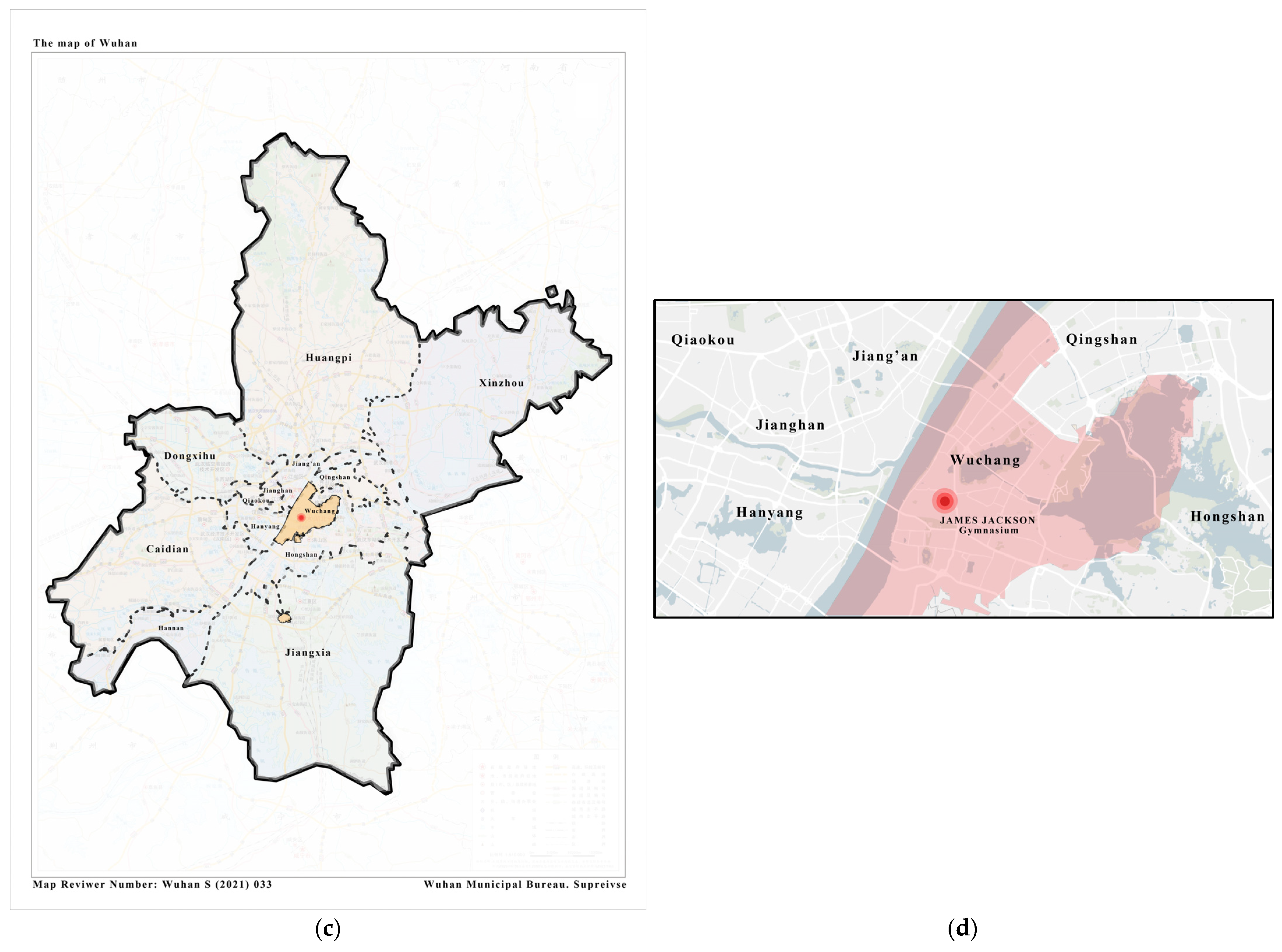
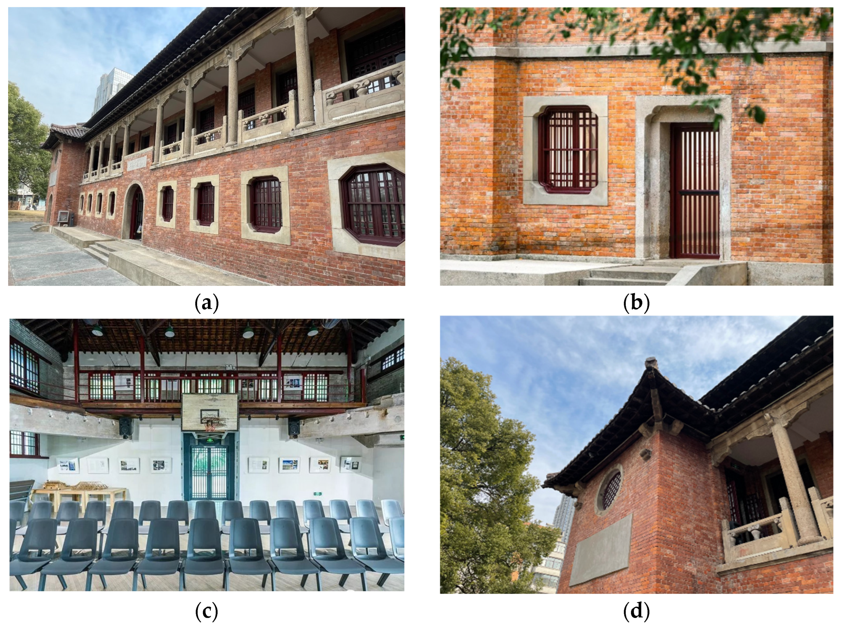
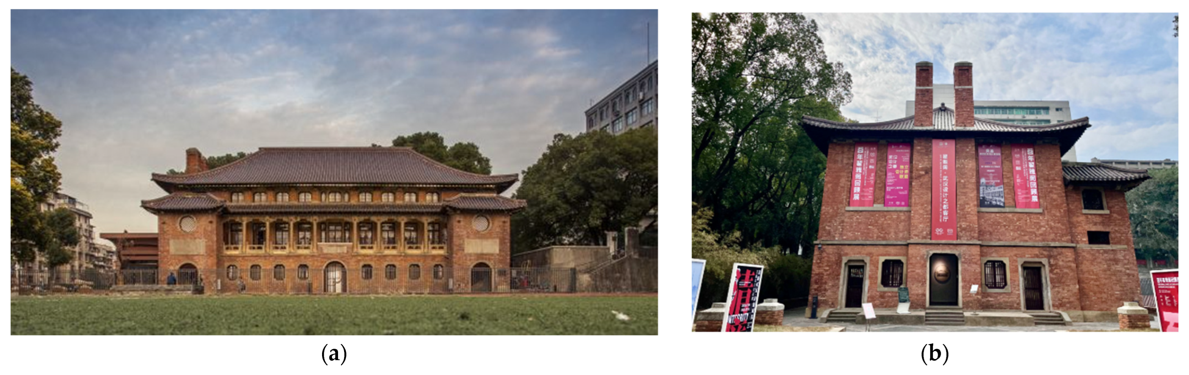
3.1.1. Study Area
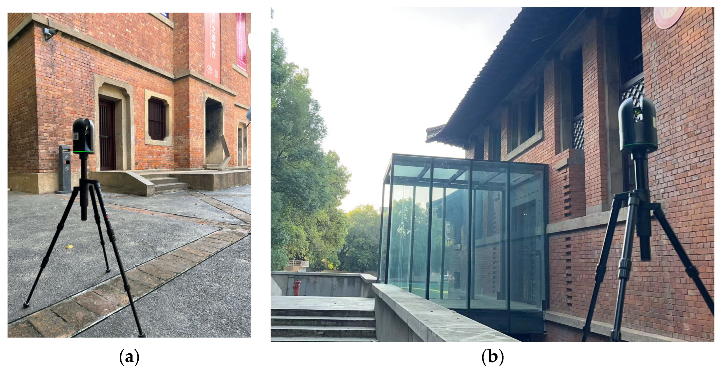
3.1.2. Data Collection
3.2. Methods
3.2.1. Research Methods
- Three-dimensional laser scanning
- BIM modeling
- Computer simulation
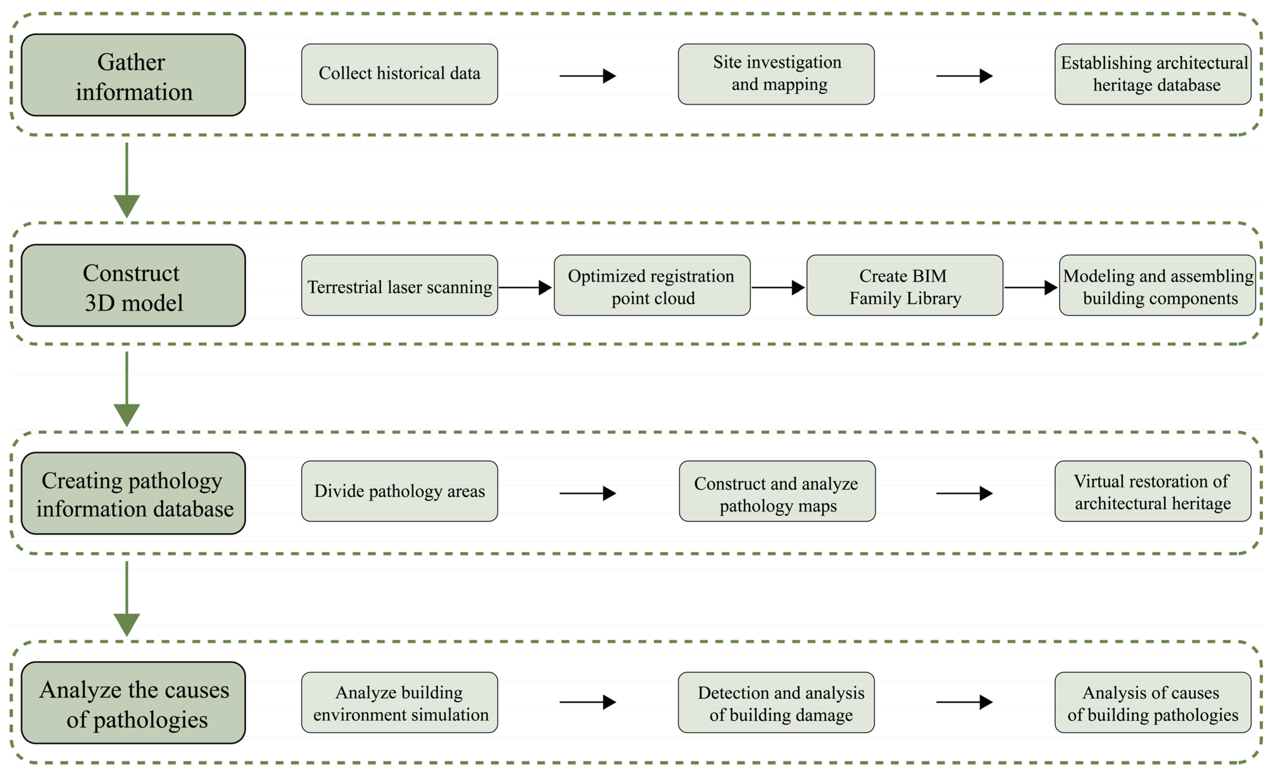
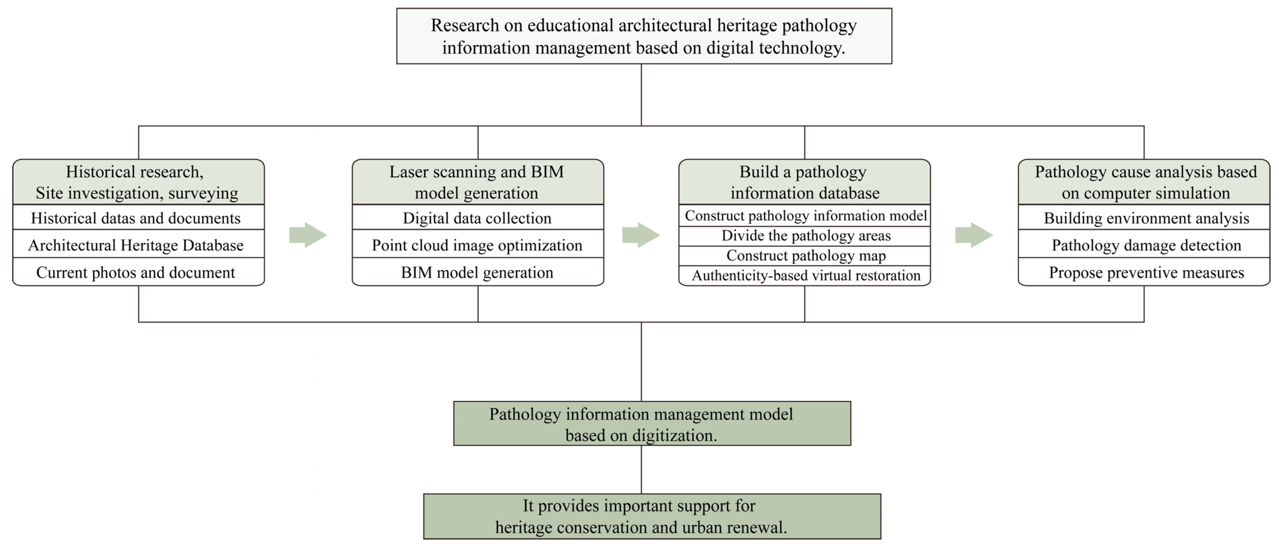
3.2.2. Research Path Design
4. Results
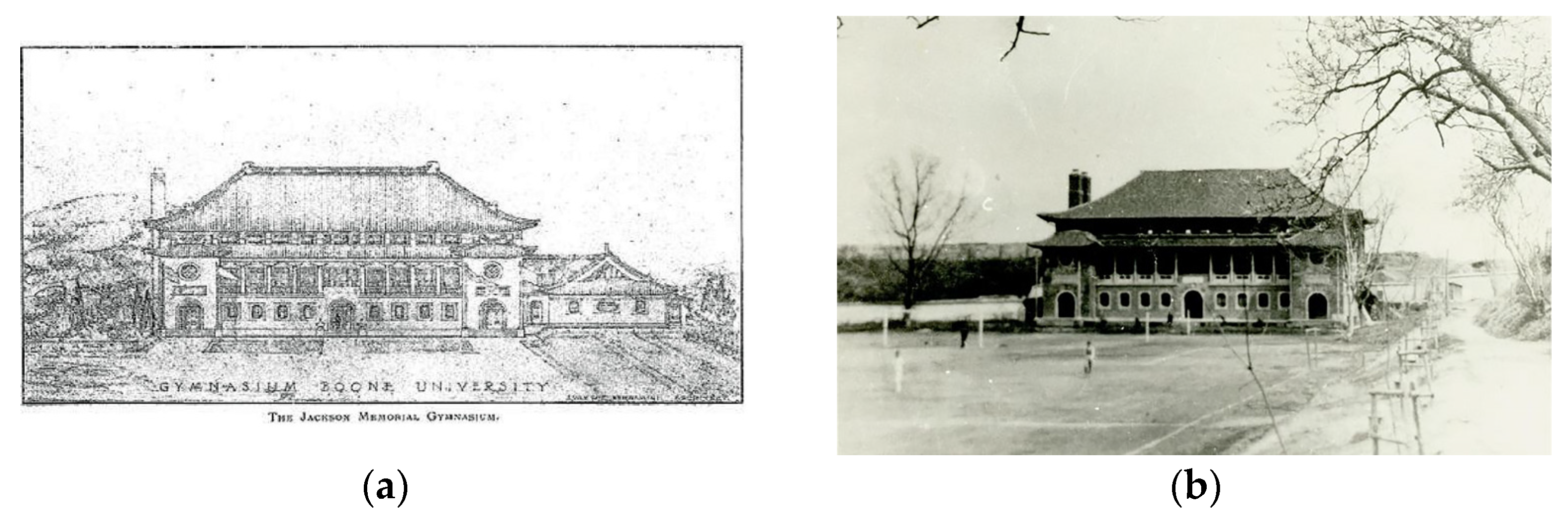
4.1. Historical Research and Site Surveying
4.2. Laser Scanning and BIM Model Generation
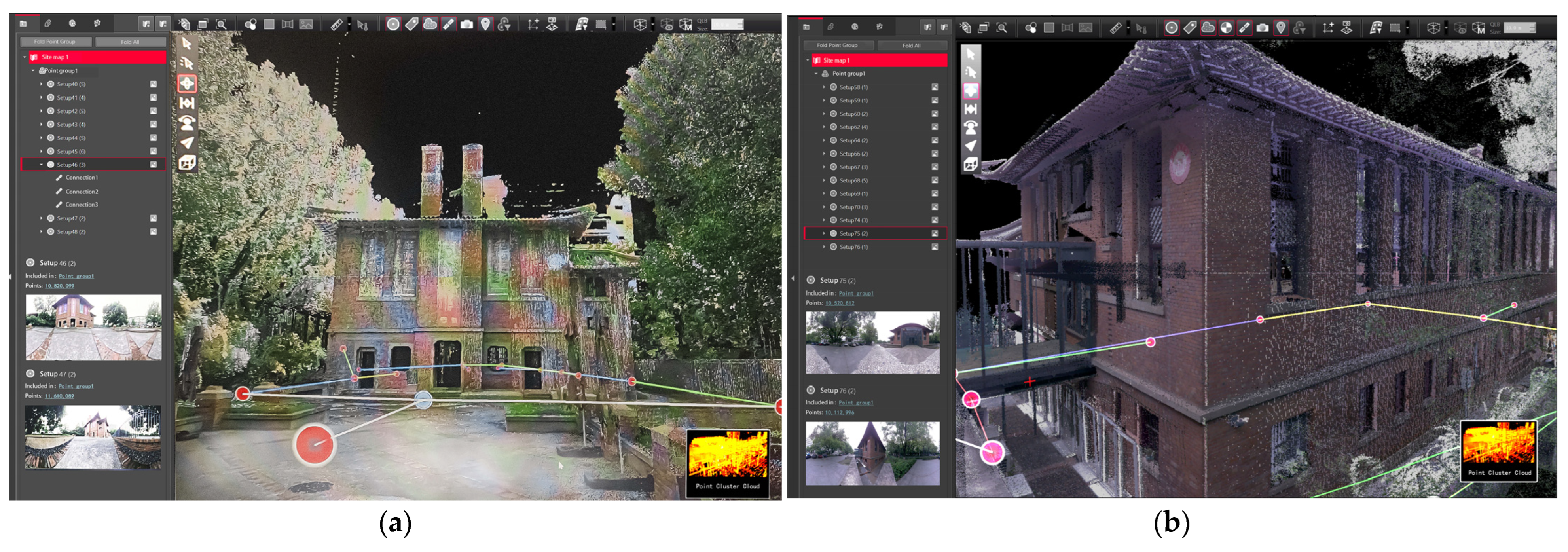
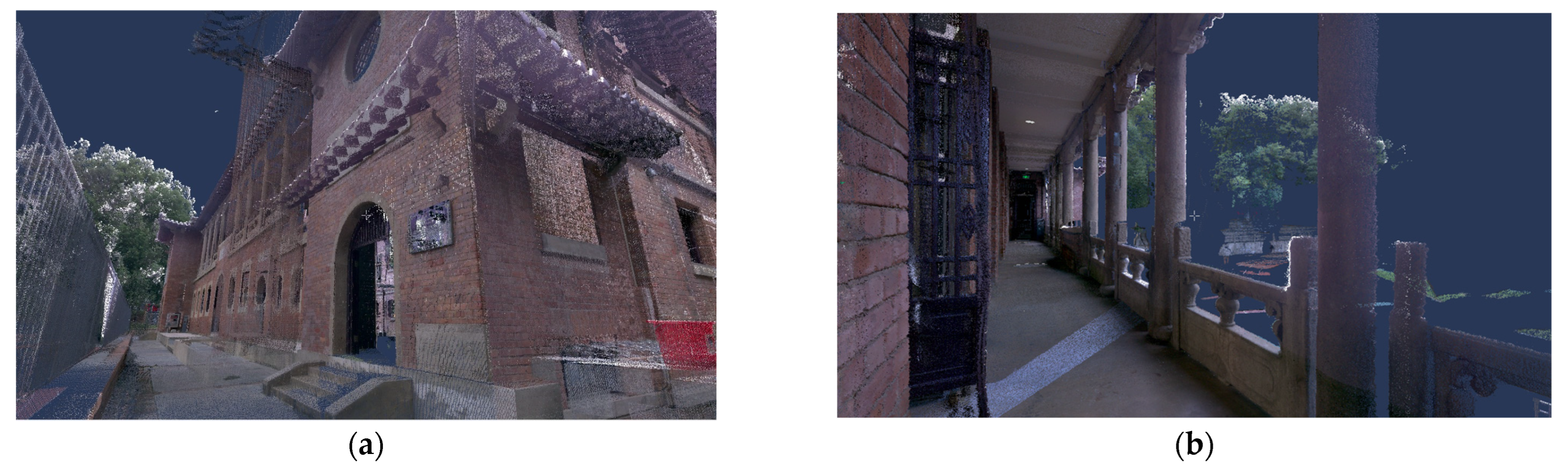
4.2.1. Digital Data Collection
4.2.2. Point Cloud Image Optimization
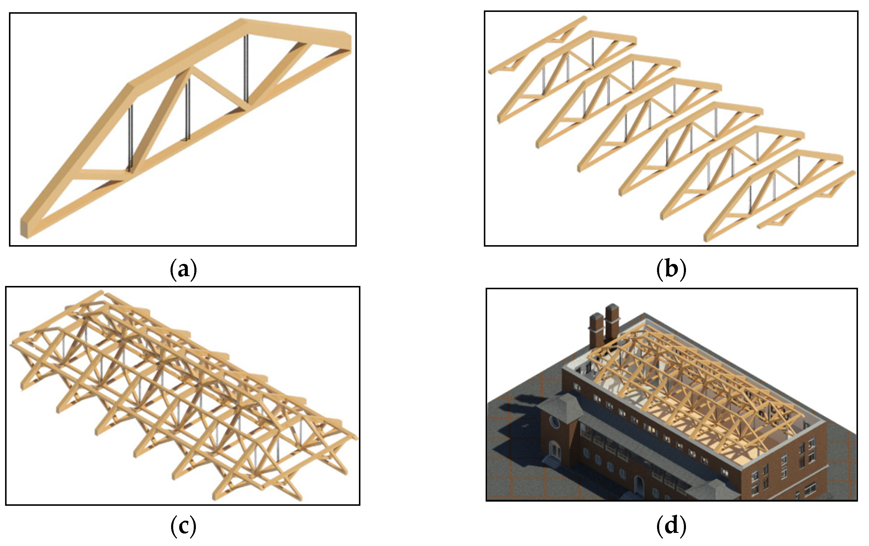
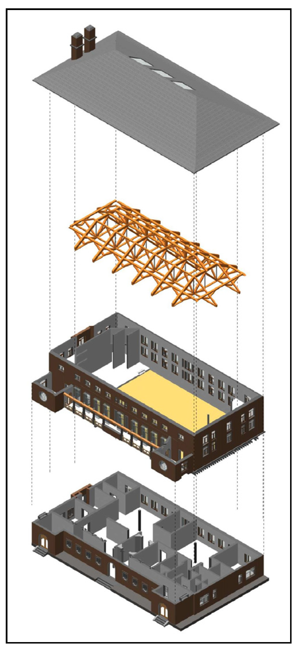
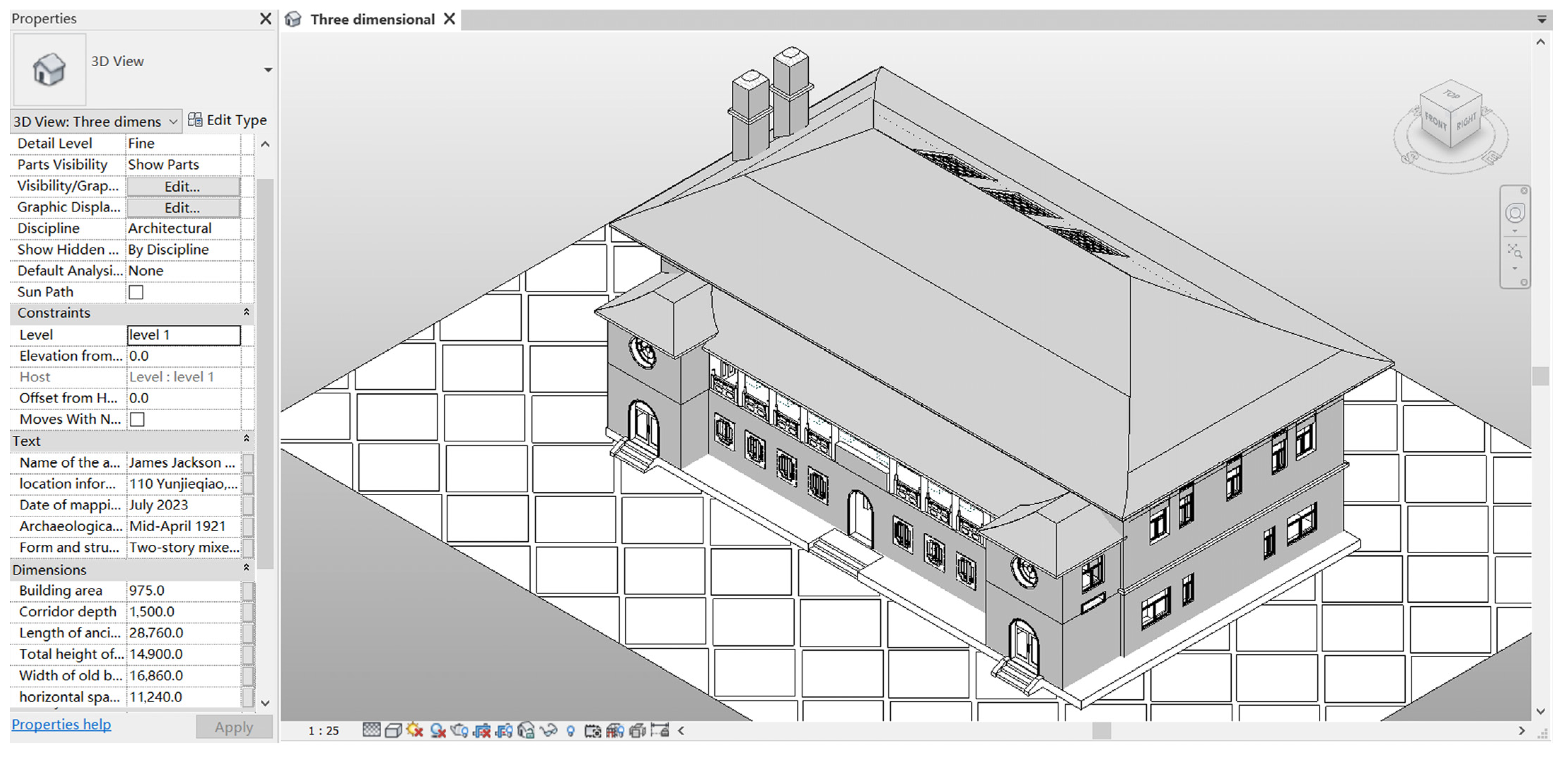
4.2.3. BIM Model Generation
4.3. Build a Pathology Information Database
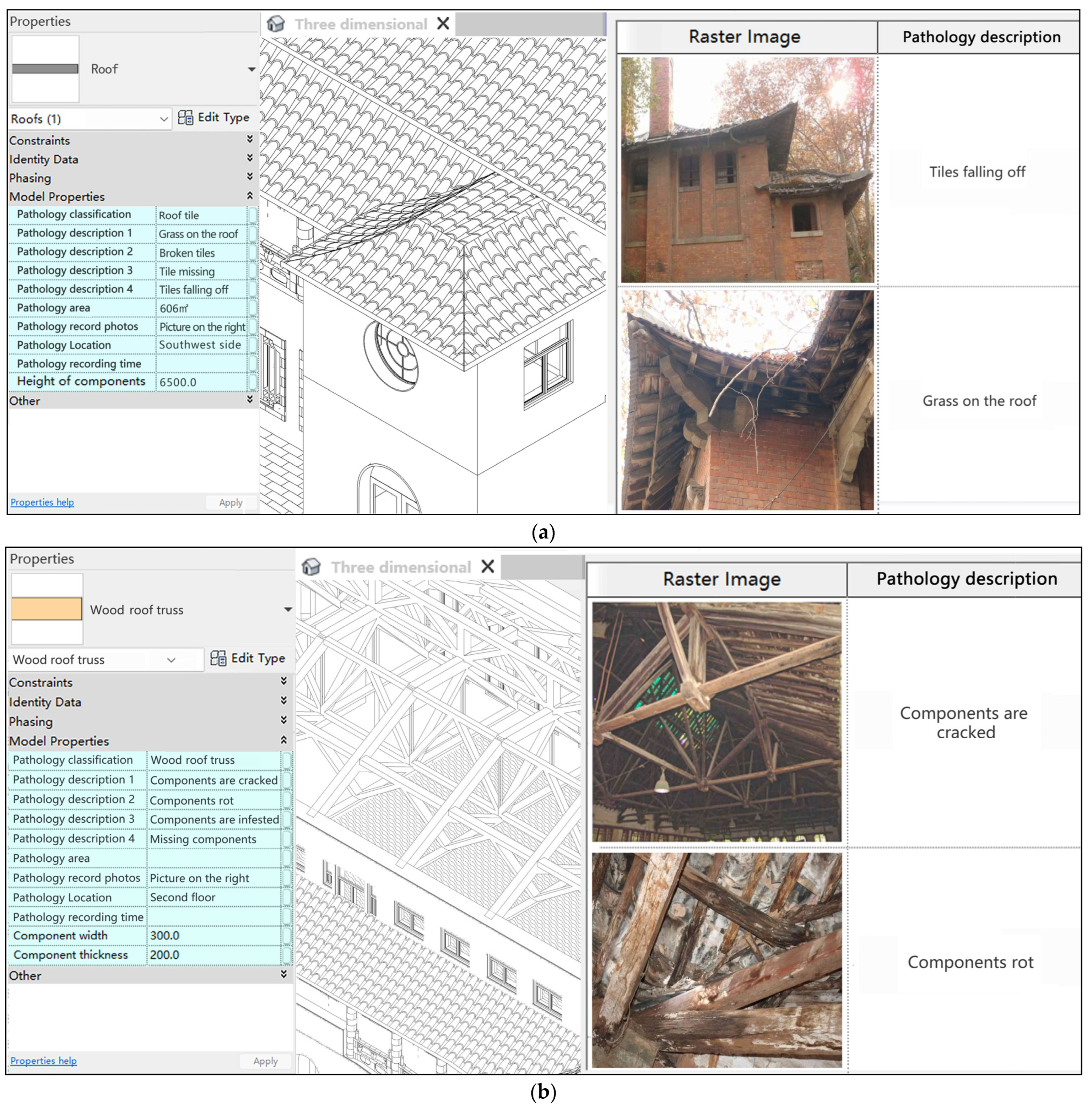
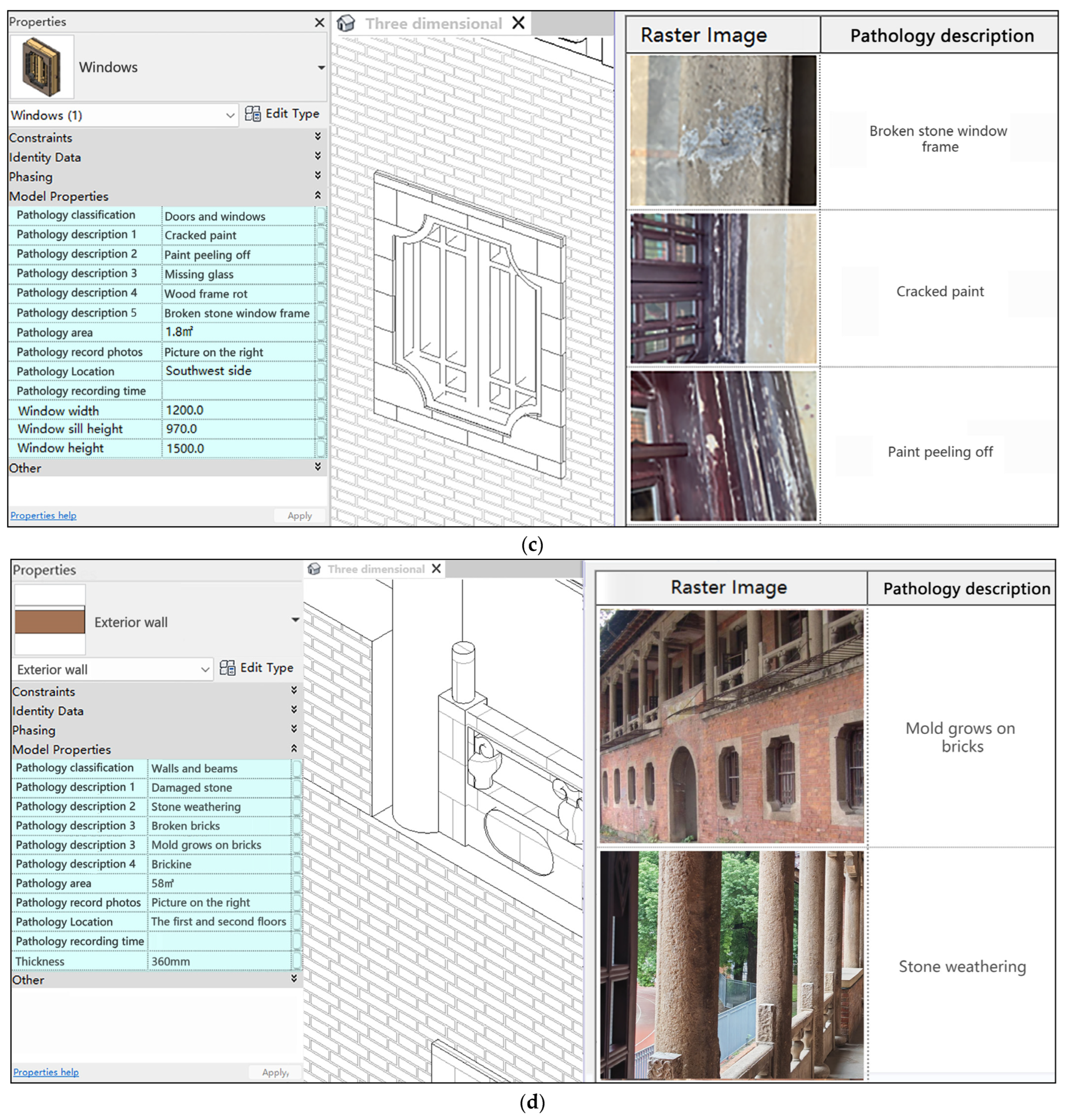
4.3.1. Construct Historical Building Pathology Information Model
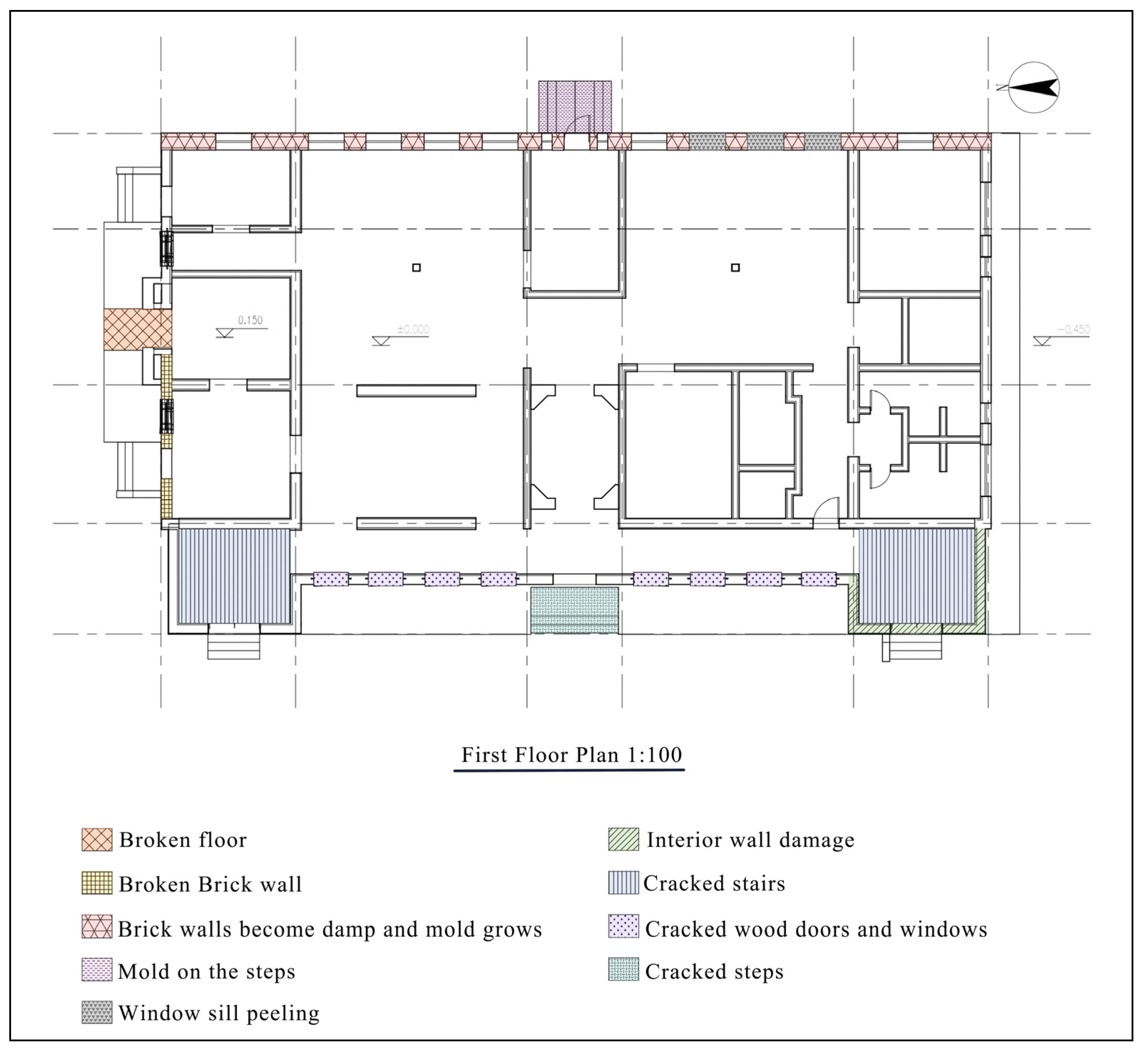
4.3.2. Divide the Pathology Areas of the BIM Model
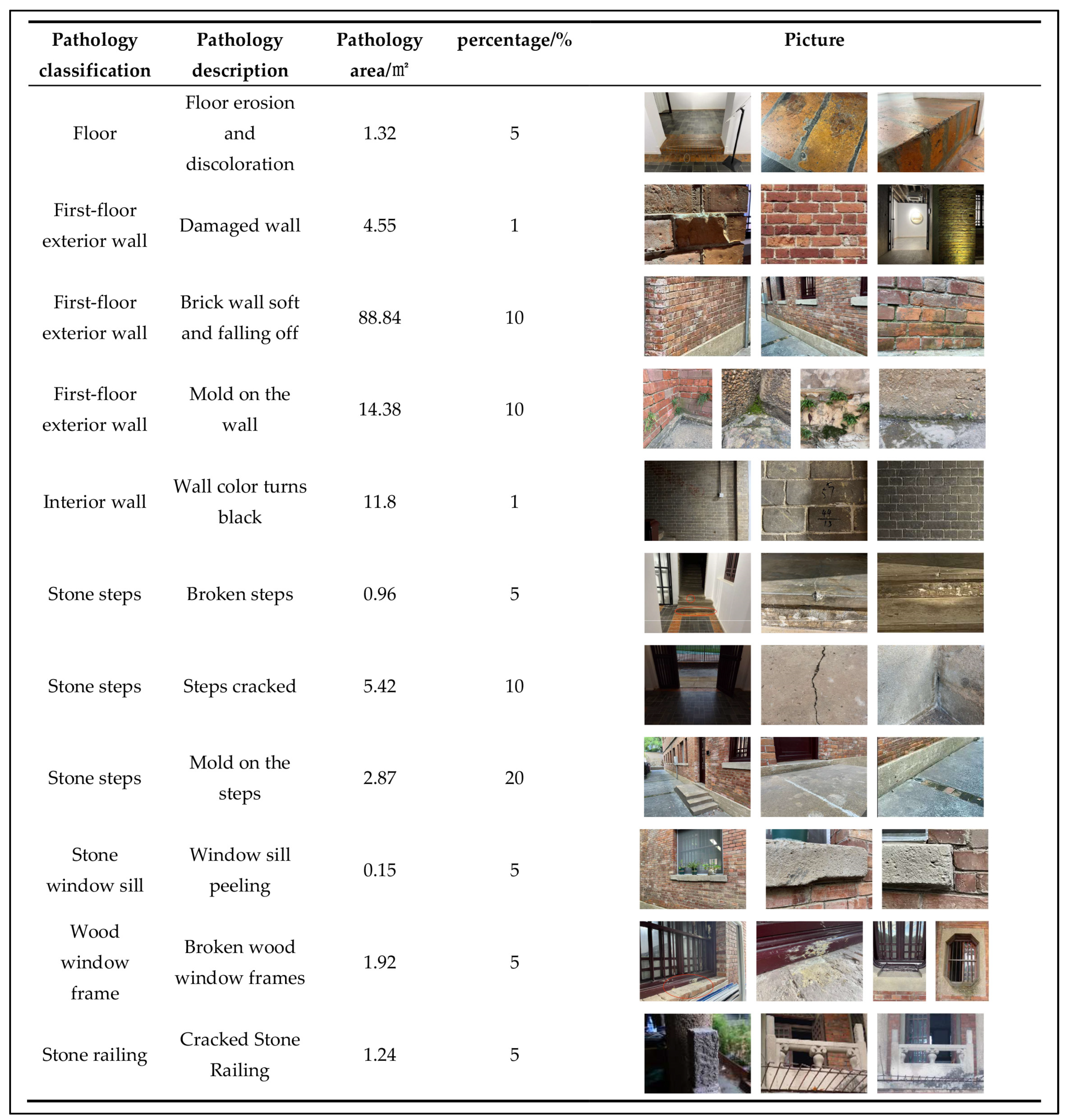
4.3.3. Construct and Analyze BIM Pathology Map
4.3.4. Authenticity-Based Virtual Restoration
4.4. Pathology Cause Analysis Based on Computer Simulation
4.4.1. Building Environment Analysis
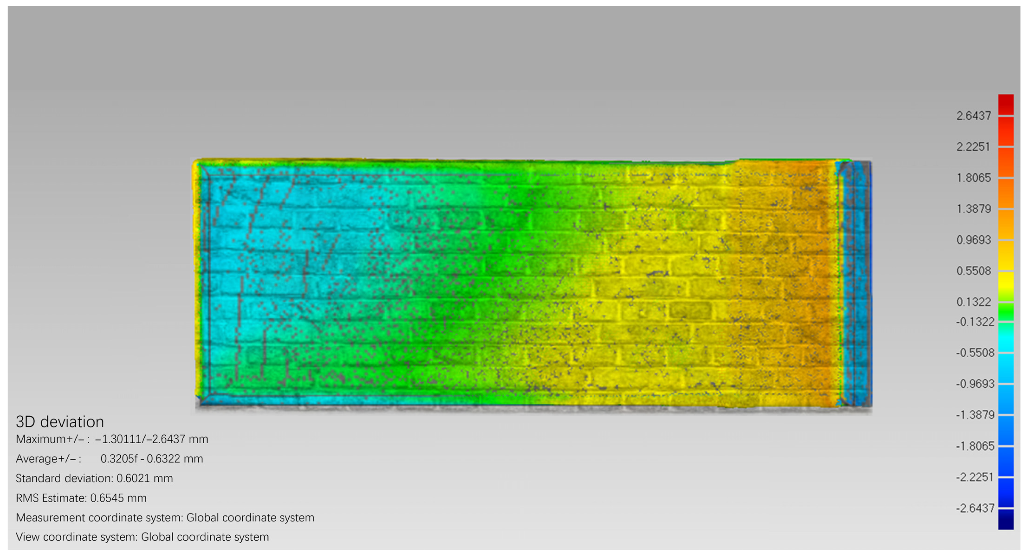
4.4.2. Building Pathology Damage Detection and Analysis
5. Discussion
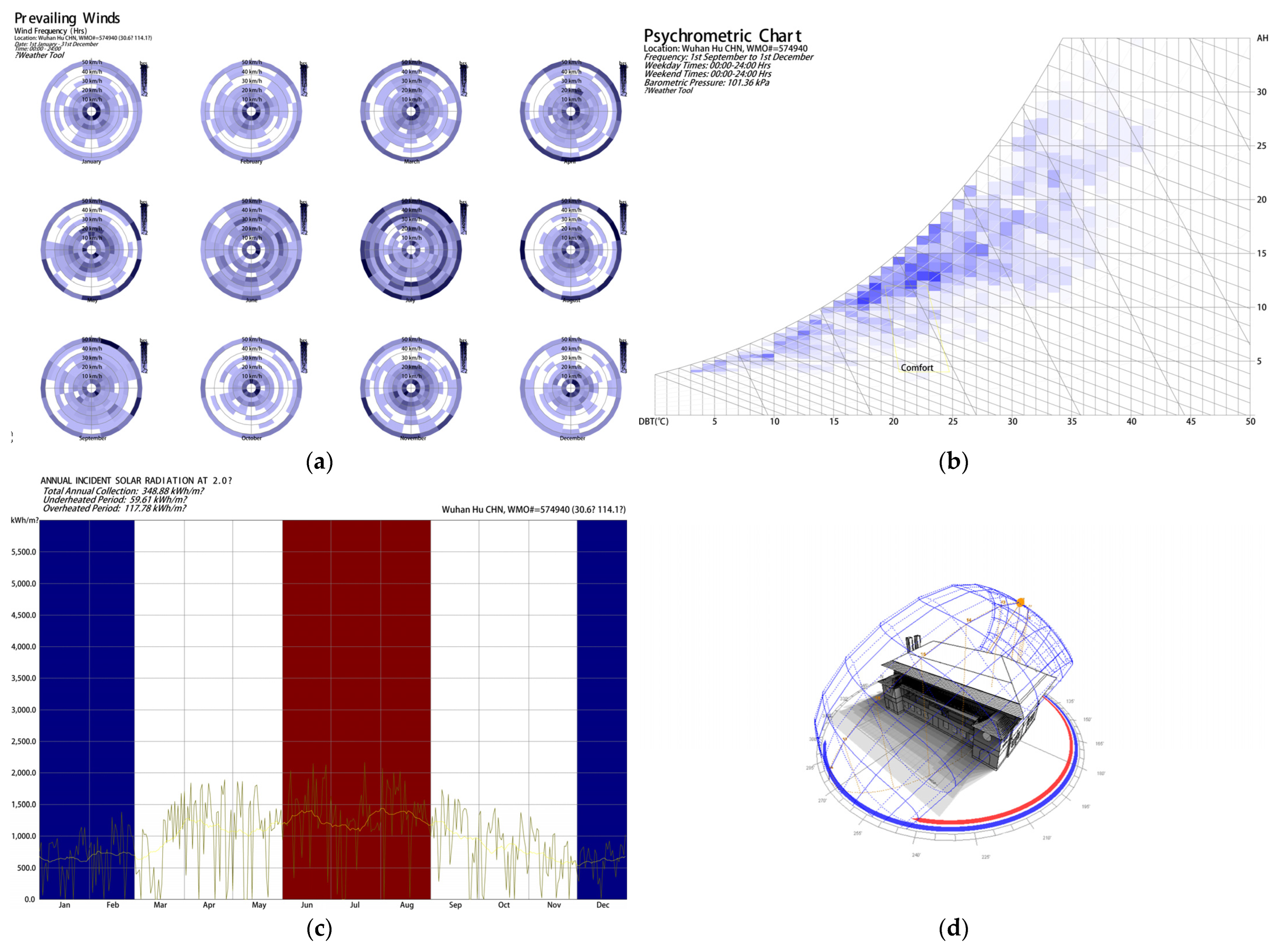
- Solar radiation: Due to the oxidizing effect of long-wave and short-wave radiation from sunlight, the walls and paintings of historical buildings will crack, become alkali, fall off, fade, and enter other aging states. In the absence of sunlight, some wooden columns, beams, and other wooden components will rot. To address this type of problem, we can use polymer materials or iron components to reinforce the structure, and protect the walls with radiation-resistant materials suitable for painting [65].
- Temperature effect: It is one of the important factors that affect the longevity of historical buildings. Generally, the temperature is around 20 °C. Too high or too low temperatures and changes in temperature differences will cause damage and deformation to the materials of historical buildings. Wuhan belongs to a subtropical monsoon climate zone, with cold winters and hot summers, which are the main factors affecting the deformation and cracking of materials such as wood and tiles.
- Effect of humidity: Its destructive power is manifested in two aspects: increasing the moisture content of wood and breeding fungi. Fungi generally gain moisture from soil or moist materials; the continued increase in moisture can exacerbate the development of pathologies such as mold growth, vesicle formation, peeling paint on walls, and falling mortar. The average precipitation in Wuhan from June to July reaches 210 mm, the relative humidity reaches more than 75%, and the solar radiation is abundant, which provides a suitable environment for plant growth. For example, grass growing on the roof causes the position of the tiles to change and the gaps between the tiles to become larger. Moss or mold will grow on the walls after becoming wet, and wooden components will rot after becoming wet. Therefore, measures such as dehumidification and moisture-proofing are very important. We can use chemical materials or physical instruments for dehumidification, such as activated carbon, calcium oxide, phosphorus pentoxide, dehumidifiers, etc. If conditions permit, infrared thermal imaging cameras can be used to conduct regular inspections of building walls [66].
- Weathering: Most historical buildings have tile roofs. Strong winds will not only blow away or damage the roof tiles, but also blow down buildings with lower strength and weather the building components. For example: stone components are generally located outdoors. When the temperature, humidity, and rainfall are high, the weathering of the stone will be accelerated. In order to prevent stone weathering, silicone coatings and other materials can be added to the surface of the material to prevent stone wind erosion. Stone components can also be repaired using the same material, adhering to the principle of “minimum intervention” for cultural relic restoration, to achieve the effects of removing pathologies, restoring functions, improving the look and feel of stone components, and extending the life of cultural relics [67].
6. Conclusions
Author Contributions
Funding
Data Availability Statement
Acknowledgments
Conflicts of Interest
References
- Notice of the General Office of the State Council on Issuing the “14th Five-Year Plan” Cultural Relics Protection and Scientific and Technological Innovation Plan. Available online: https://www.gov.cn/zhengce/content/2021-11/08/content_5649764.htm (accessed on 10 February 2024).
- Mo, G. Application and practice of 3D laser scanning technology in historical building mapping. China High New Technol. 2023, 12, 136–138. [Google Scholar]
- Shen, H. Research on the Urban Heritage Conservation: In the View of “Collective Choice”. Ph.D. Thesis, Tongji University, Shanghai, China, 2006. [Google Scholar]
- Wu, Y.; Li, J.; Li, X. Systematic Experiences on the U.S. Campus Heritage Preservation and Its Implications. Chin. Landsc. Archit. 2021, 2, 112–117. [Google Scholar]
- Zhai, Y. Research on Fire Protection and Sustainable Conservation and Utilization of Educational Architectural Heritage-The Example of Modern Building Complex of Henan University. Master’s Thesis, Henan University, Zhengzhou, China, 2022; p. 2. [Google Scholar]
- Guan, X.; Lin, X.; Hu, S.; Lu, S. Relationship between transportation system and urban spatial expansion in Wuhan Urban. Prog. Geogr. 2024, 33, 702–712. [Google Scholar]
- Wu, Y. A Study on the Design of Wuhan Modern Education Building. Master’s Thesis, Wuhan University of Technology, Wuhan, China, 2008; p. 20. [Google Scholar]
- Sacks, R.; Eastman, C.; Lee, G.; Teicholz, P. BIM Handbook: A Guide to Building Information Modeling for Owners, Managers, Designers, Engineers and Contractors; John Wiley & Sons: Hoboken, NJ, USA, 2011. [Google Scholar]
- Borkowski, A.S. A Literature Review of BIM Definitions: Narrow and Broad Views. Technologies 2023, 11, 176. [Google Scholar] [CrossRef]
- Li, Y.; Li, G.; Dong, K. Key Factors of the Protection of Historical Buildings Analyzed by BIM Technology. Nat. Sci. J. Hainan Univ. 2015, 3, 258–263. [Google Scholar]
- Dore, C.; Murphy, M.; McCarthy, S.; Brechin, F.; Casidy, C.; Dirix, E. Structural Simulations and Conservation Analysis-Historic Building Information Model (HBIM). Int. Arch. Photogramm. Remote Sens. Spat. Inf. Sci. 2015, 40, 351–357. [Google Scholar] [CrossRef]
- Angulo-Fornos, R.; Castellano-Román, M. HBIM as Support of Preventive Conservation Actions in Heritage Architecture. Experience of the Renaissance Quadrant Facade of the Cathedral of Seville. Appl. Sci. 2020, 7, 2428. [Google Scholar] [CrossRef]
- Shi, R.; Liu, H.; Wang, R.; Wei, Z. Study on Building Ancient Architecture Information Model of Fuxue Hutong 36 Yard. J. Beijing Univ. Civ. Eng. Archit. 2014, 4, 1–7. [Google Scholar]
- Yang, Z.; Ren, K.; Liu, C.; Li, X. The establishment of Heiden-Shan ancient building information model based on BIM technology. J. Shandong Jianzhu Univ. 2020, 4, 25–30. [Google Scholar]
- Ma, J. Application of BIM in the Repair of Zhenhai Bridge in Huangshan City. Master’s Thesis, Anhui Jianzhu University, Hefei, China, 2023; pp. 53–70. [Google Scholar]
- Li, Q. The Research of BIM’s Application toward the Conservation of Architecture Heritage in Shibaozhai. Master’s Thesis, Beijing University of Civil Engineering and Architecture, Beijing, China, 2016; pp. 36–49. [Google Scholar]
- Stanga, C.; Banfi, F.; Roascio, S. Enhancing Building Archaeology: Drawing, UAV Photogrammetry and Scan-to-BIM-to-VR Process of Ancient Roman Ruins. Drones 2023, 7, 521. [Google Scholar] [CrossRef]
- Ma, Y.-P. Extending 3D-GIS District Models and BIM-Based Building Models into Computer Gaming Environment for Better Workflow of Cultural Heritage Conservation. Appl. Sci. 2021, 11, 2101. [Google Scholar] [CrossRef]
- Ji, X.; Fang, X.; Shim, S.H. Design and development of a maintenance and virtual training system for ancient Chinese architecture. Multimed. Tools Appl. 2018, 77, 29367–29382. [Google Scholar] [CrossRef]
- Baik, A. The Use of Interactive Virtual BIM to Boost Virtual Tourism in Heritage Sites, Historic Jeddah. ISPRS Int. J. Geo-Inf. 2021, 10, 577. [Google Scholar] [CrossRef]
- Shang, D.; Yuan, H. Research on Visualization of HBM Technology in Architectural Heritage Data under the Background of Internet+—A Case Study of Huangxi Academy. J. Chang. Univ. 2021, 4, 37–41. [Google Scholar]
- Li, K. Informatization Survey and Measurement of Jiayuguan Pass based on HBIM: Taking the Timber Buildings as an Example. Master’s Thesis, Tianjin University, Tianjin, China, 2016; pp. 33–59. [Google Scholar]
- Ferraz, G.; de Brito, J.; de Freitas, V.; Silvestre, J. State-of-the-Art Review of Building Inspection Systems. J. Perform. Constr. Facil. 2016, 30, 04016018. [Google Scholar] [CrossRef]
- Acampa, G.; Grasso, M. Heritage Evaluation: Restoration plan through HBIM and MCDA. In IOP Conference Series: Materials Science and Engineering; IOP Publishing: Bristol, UK, 2020; Volume 949, pp. 012061–012069. [Google Scholar] [CrossRef]
- Liu, X.; Sun, Z. Discussion on the deformation monitoring design plan of the ancient city wall in Pingyao, Shanxi. Sci. Technol. West China 2013, 8, 2–3. [Google Scholar]
- Sanchez, M.; Navacerrada, M.; Fort, R.; Barbero-Barrera, M. Assessment of limestone cladding deterioration due to crystallisation of salts by non-destructive techniques. Constr. Build. Mater. 2023, 400, 132640. [Google Scholar] [CrossRef]
- He, Y.; Cai, J.; Wang, J.; Yu, Z.; Guan, Z.; Zhou, D. Modeling and repairing of ancient city wall by three dimensional laser scanning technology. Laser J. 2018, 2, 5–6. [Google Scholar]
- Dai, J. The Research on Modern Educational Architecture in Wuhan. Master’s Thesis, Huazhong University of Science and Technology, Wuhan, China, 2006; pp. 15–16. [Google Scholar]
- Li, Z.; Pi, M. History of Education in Ancient and Modern Wuhan; Wuhan Publishing House: Wuhan, China, 1999; p. 34. [Google Scholar]
- Xu, Q. Protection and Utilization of the Former Site of James Jackson Gymnasium. Jianghan Archaeol. 2015, 4, 122–125. [Google Scholar]
- Liu, J.; Willkens, D.; Gentry, R. A Conceptual Framework for Integrating Terrestrial Laser Scanning (TLS) into the Historic American Buildings Survey (HABS). Architecture 2023, 3, 505–527. [Google Scholar] [CrossRef]
- Chen, L.; Xu, Y.; Yu, G. Wuhan Modern Educational Architecture; Wuhan University of Technology Press: Wuhan, China, 2018; pp. 84–95. [Google Scholar]
- Liu, X.; Zhang, F.; Shin, M.; Terahara, J. The Architectural Heritage of Modern China Wuhan; China Architecture Publishing & Media Co., Ltd.: Beijing, China, 1992; pp. 17–33. [Google Scholar]
- Pi, M. Modern Wuhan City History; China Social Sciences Press: Beijing, China, 1993; pp. 77–85. [Google Scholar]
- Chen, Y.; Wu, Y.; Sun, X.; Ali, N.; Zhou, Q. Digital Documentation and Conservation of Architectural Heritage Information: An Application in Modern Chinese Architecture. Sustainability 2023, 15, 7276. [Google Scholar] [CrossRef]
- Ochmann, S.; Vock, R.; Klein, R. Automatic Reconstruction of Fully Volumetric 3D Building Models from Oriented Point Clouds. ISPRS J. Photogramm. Remote Sens. 2019, 151, 251–262. [Google Scholar] [CrossRef]
- Liu, B. Research and Application of 3D Intelligent Management and Control Platform Based on BIM. Software 2018, 8, 74–77. [Google Scholar]
- Gawronek, P.; Makuch, M.; Mitka, B.; Gargula, T. Measurements of the Vertical Displacements of a Railway Bridge Using TLS Technology in the Context of the Upgrade of the Polish Railway Transport. Sensors 2019, 19, 4275. [Google Scholar] [CrossRef] [PubMed]
- Warchoł, A. The Concept of Lidar Data Quality Assessment in the Context of Bim Modeling. Int. Arch. Photogramm. Remote Sens. Spat. Inf. Sci. 2019, 12, 61–66. [Google Scholar] [CrossRef]
- Wang, R.; Han, T. Standardized Management Research on Ancient Building Components Information Classification and Encoding Based on BIM. Constr. Technol. 2015, 24, 105–109. [Google Scholar]
- Yuan, H.; Xiong, L.; Xia, Q. Autodesk Ecotect Analysis Green Building Analysis Application; Publishing House of Electronics Industry: Beijing, China, 2012; pp. 47–70. [Google Scholar]
- Liu, K. Application of 3D Laser Geometry Acquiring Based on the Requirement of Ancient Architecture Conservation and Renovation. Ph.D. Thesis, Beijing University of Technology, Beijing, China, 2019; pp. 39–45. [Google Scholar]
- Shi, R. Research on the Application of BIM Technology, 3D Scanning Technology and GIS Technology in the Restoration and Protection of Ancient Buildings. Software 2020, 9, 123–126. [Google Scholar]
- Zhou, C. Dictionary of Chinese Modern Higher Education Figures; Fujian Education Press: Fuzhou, China, 2012; pp. 715–717. [Google Scholar]
- Wuhan City Excellent Historical Building Website. Available online: http://119.97.201.28:7500/HistoryBuilding.aspx?HBId=160 (accessed on 10 February 2024).
- Wu, S.; Xu, Y. Development of Digital Display Platform and Simulation Experience System of Historic Buildings Based on BIM—Taking James Jackson Museum as an Example. Constr. Des. Eng. 2021, 21, 132–137. [Google Scholar]
- Thoughts on the Protection, Repair and Utilization of James Jackson Gymnasium. Available online: http://www.heritagewuhan.cn/page?detail&type=yichanbaohuyushenyi&aid=f8cc1c7057f7c82701580016b5570070 (accessed on 10 February 2024).
- Liu, C. Research on Digital Strategies for Contemporary Architectural Heritage Protection; China Commercial Publishing House: Beijing, China, 2021; pp. 131–132. [Google Scholar]
- Liu, X.; Ren, P.; Sun, X.; Xu, C.; Zhou, M. 3D Digitalization of Chinese Ancient Architecture: A Survey. J. Shanxi Univ. (Nat. Sci. Ed.) 2023, 3, 592–603. [Google Scholar]
- Gao, C.; Zhao, X.; Gao, S.; Guo, T.; Li, P. Research on the application of BIM in the construction of a super high-rise China honor project. Steel Constr. (Chin. Engl.) 2016, 6, 88–91. [Google Scholar]
- Gao, Y.; Chen, M.; Huang, Y. Research on the digital protection of Dongguan historical buildings. Bull. Surv. Mapp. 2021, 7, 140–143. [Google Scholar]
- Gao, X.; Zhou, D.; Cui, W. Research on the application of ancient architecture based on 3D laser scanning and BIM. Bull. Surv. Mapp. 2019, 5, 158–162. [Google Scholar]
- Tan, Q. Research on the application of BIM model reconstruction of ancient buildings based on 3D scanning and drone oblique photography technology. Anhui Archit. 2020, 9, 6–7. [Google Scholar]
- Xia, L.; Wei, Z. Application of 3D Laser Scanning Survey in Digital Archiving of Historical Buildings. Geomat. Spat. Inf. Technol. 2023, 2, 193–195. [Google Scholar]
- Grilli, E.; Remondino, F. Classification of 3D Digital Heritage. Remote Sens. 2019, 11, 847. [Google Scholar] [CrossRef]
- Fang, L.; Zhang, S.; Sun, X. Implementation of the Damage Database for Historical Buildings with Safety Risk Exposure. Urban. Archit. 2019, 25, 19–22. [Google Scholar]
- Zeng, T. Research and Application of Non-Contact Detection Technology for Common Diseases on Interior Walls of Historical Buildings. Master’s Thesis, Huazhong University of Science and Technology, Wuhan, China, 2022; pp. 48–66. [Google Scholar]
- Li, X. The Application of 3D Laser Point Cloud Data in Protection and Repair of Ancient Buildings. Master’s Thesis, Beijing University of Technology, Beijing, China, 2018; pp. 38–42. [Google Scholar]
- Lucchi, E. Review of preventive conservation in museum buildings-ScienceDirect. J. Cult. Herit. 2018, 29, 180–193. [Google Scholar] [CrossRef]
- He, L.; Cui, X.; Hu, Q. Estimation and Simulation of Energy Consumption of Public Buildings Based on BIM. J. Eng. Manag. 2020, 2, 84–89. [Google Scholar]
- ERA5-Land Monthly Averaged Data from 1950 to Present. Available online: https://cds.climate.copernicus.eu/cdsapp#!/dataset/reanalysis-era5-land-monthly-means?tab=form (accessed on 26 February 2024).
- Zhang, X. The application of 3D laser scanning in the safety detection of ancient buildings. Bull. Surv. Mapp. 2020, S1, 155–158. [Google Scholar]
- Zhao, J.; Liu, J.; Zhang, D.; Pei, Q.; Liu, H. Research on visualization of Cave Temple diseases based on 3D laser scanning. Res. Conserv. Cave Temples 2022, 2, 72–80. [Google Scholar]
- Kong, J. Research on preventive protection and maintenance technology of ancient wooden structures-taking Qufu Confucius Temple as an example. China Natl. Exhib. 2020, 12, 178–179. [Google Scholar]
- Xiang, N.; Yang, H.; Li, X. Discussing Internet Monitoring Plan for Historical Building Protection. J. Hunan Inst. Sci. Technol. (Nat. Sci.) 2016, 3, 71–75. [Google Scholar]
- Maurício, R.; Enrico, G.; Letícia, S.; Yuri, C.; Eneida, A.; Renan, P. Salvador. Infrared thermal imaging to inspect pathologies on façades of historical buildings: A case study on the Municipal Market of São Paulo, Brazil. Case Stud. Constr. Mater. 2022, 16, e01122. [Google Scholar]
- Yu, X.; Dong, R.; Guo, H. The Disease Mechanism, Protection and Restoration of the Stone Projection in the Forbidden City-Case Study on Sumeru Seat. Tradit. Chin. Archit. Gard. 2020, 2, 70–74. [Google Scholar]


| Distribution Area | Heritage Statistics | Heritage Name | Number of Heritage Items on Campus | Location | Age |
|---|---|---|---|---|---|
| Wuchang | 64 | Boone Memorial School | 7 | No. 110 Yunjiaqiao, Wuchang District | 1871. |
| London Mission Hospital for Men/Women in Wuchang | 1 | No. 4 Huayuanshan, Wuchang District | 1895. | ||
| Wuchang Shandao Girls’ Senior School | 2 | No. 116 Shouyi Road, Wuchang District | 1936. | ||
| San Garn Girl’s Middle School | 1 | Fuxing road, District Wuchang | 1912. | ||
| Boone School | 1 | No. 71 Liangdao Street, Wuchang District | 1871. | ||
| Gude Girl’s Middle School | 1 | No. 101 Tanhualin, Wuchang District | 1897. | ||
| Truth Middle School | 3 | No. 115 Tanhualin, Wuchang District | 1890. | ||
| St. Hillida Women’s Middle School | 3 | No. 444 Wuluo Road, Wuchang District | 1911. | ||
| Bowen College | 8 | No. 257 Wuluo Road, Wuchang District | 1904. | ||
| Early Buildings of Wuhan University | 11 | Luojia Hills, Wuchang District | 1928. | ||
| Wuhan University Kindergarten | 3 | Luojia Hills, Wuchang District | 1936. | ||
| Primary School Affiliated to Wuhan University | 4 | Luojia Hills, Wuchang District | 1945. | ||
| Wuhan High School | 4 | No. 275 Liangdao Street, Wuchang District | 1920. | ||
| Hubei Provincial Library | 1 | No. 45 Wuluo Road, Wuchang District. | 1936. | ||
| Lianghu Academy | 3 | No. 259 Jiangfang Road, Wuchang District | 1927. | ||
| Wuchang Higher Normal School Attached Primary School | 3 | No. 69 DuFuDi, Wuchang district | 1913. | ||
| North Road School (Peasant Movement Institute) | 6 | No. 13 Hongxiang, Wuchang District | 1927. | ||
| Hubei Women’s Vocational High School | 1 | No. 32 Tanhualin, Wuchang District | 1913. | ||
| Provincial No. 1 Middle School | 1 | No. 141 Tanhualin, Wuchang District | 1912. | ||
| Hankou | 8 | Boxue Middle School | 3 | No. 171 Jiefang Boulevard, Qiaokou District | 1905. |
| Dehua Shutang | 1 | No. 64 Qiuchang Street, Jiang’an District | 1908. | ||
| St. Joseph’s School | 1 | No. 222 Zizhi Street, Jiang’an District | 1925. | ||
| British Primary School | 1 | No. 16 Tianjian road, Jiang’an District | 1911. | ||
| Hankou Women’s Middle School | 1 | Simin Street, Hankou District | 1930. | ||
| Hankou Saint Roui Girl Middle School | 1 | No. 52 Hezuo Road, Jiang’an District | 1931. | ||
| Hanyang | 2 | Xunnv Middle School | 1 | No. 24 Beicheng Lane, Hanyang District | 1936. |
| Wuhan No. 3 Middle School | 1 | Sixin North Road, Hanyang District | 1945. | ||
| Total | 74 | ||||
| Instrument | Weight [kg] | Range [m] | Range Accuracy | Field of Vision [°] |
|---|---|---|---|---|
| Leica Geosystem BLK360 | M = 1 | 0.6 < S < 60 | 4 mm @10 m 7 mm @20 m | 300 V 360 H |
| Classification | Family and Type | Height /Thickness (mm) | Volume/m3 |
|---|---|---|---|
| Pillar family | Column 1: 300 × 300 mm | 4000 | 0.64 |
| Column 2: 300 × 300 mm | 5000 | 0.80 | |
| Square column 1: 230 × 230 mm | 4000 | 0.22 | |
| Square column 2: 230 × 230 mm | 5000 | 0.27 | |
| Girder family | T-section beam 1: 500 × 450 mm | 15,700 | 3.53 |
| T-section beam 2: 500 × 450 mm | 17,500 | 3.93 | |
| Door family | Double paneled wooden door 1: 1800 × 2100 mm | 50 | 0.20 |
| Double paneled wooden door 2: 1800 × 2100 mm | 50 | 0.25 | |
| Single-panel glass door 1: 700 × 2100 mm | 50 | 0.07 | |
| Double-swing door 1: 1200 × 2100 mm | 50 | 0.13 | |
| Window family | Casement window 1: 700 × 1500 mm | 80 | 0.08 |
| Casement window 2: 1200 × 1500 mm | 80 | 0.14 | |
| Casement window 3: 1500 × 1800 mm | 80 | 0.22 | |
| Round fixed window 1: 1200 × 1200 mm | 60 | 0.08 | |
| Queti family | Queti 1: 240 × 440 mm | 50 | 0.005 |
| Queti 2: 250 × 250 mm | 50 | 0.003 |
| Project | Describe | Numerical Value/mm |
|---|---|---|
| Damage analysis | Elevation color appears, the overall texture of the wall is greatly different, the flatness on both sides is poor, and there is damage. | Maximum difference 2.005 |
| Deviation analysis | Large deviation within the same wall | |
| Deformation analysis | Both sides of the wall are severely sunken, with a partial protrusion in the middle |
Disclaimer/Publisher’s Note: The statements, opinions and data contained in all publications are solely those of the individual author(s) and contributor(s) and not of MDPI and/or the editor(s). MDPI and/or the editor(s) disclaim responsibility for any injury to people or property resulting from any ideas, methods, instructions or products referred to in the content. |
© 2024 by the authors. Licensee MDPI, Basel, Switzerland. This article is an open access article distributed under the terms and conditions of the Creative Commons Attribution (CC BY) license (https://creativecommons.org/licenses/by/4.0/).
Share and Cite
Wang, H.; He, X.; Yan, Z.; Lei, S.; Luo, S.; Lei, J.; Zhou, Q. Research on Pathology Information Management of Educational Architectural Heritage Based on Digital Technology: The Case of James Jackson Gymnasium. Buildings 2024, 14, 1048. https://doi.org/10.3390/buildings14041048
Wang H, He X, Yan Z, Lei S, Luo S, Lei J, Zhou Q. Research on Pathology Information Management of Educational Architectural Heritage Based on Digital Technology: The Case of James Jackson Gymnasium. Buildings. 2024; 14(4):1048. https://doi.org/10.3390/buildings14041048
Chicago/Turabian StyleWang, Hechi, Xinyi He, Zhaoyi Yan, Siyu Lei, Shengzhong Luo, Jingjing Lei, and Qi Zhou. 2024. "Research on Pathology Information Management of Educational Architectural Heritage Based on Digital Technology: The Case of James Jackson Gymnasium" Buildings 14, no. 4: 1048. https://doi.org/10.3390/buildings14041048
APA StyleWang, H., He, X., Yan, Z., Lei, S., Luo, S., Lei, J., & Zhou, Q. (2024). Research on Pathology Information Management of Educational Architectural Heritage Based on Digital Technology: The Case of James Jackson Gymnasium. Buildings, 14(4), 1048. https://doi.org/10.3390/buildings14041048