
Construction of the Chinese Route of Industrial Heritage Based on Spatial and Temporal Distribution Analysis

 ,
,
Abstract
1. Introduction
2. Data Sources and Research Methodology
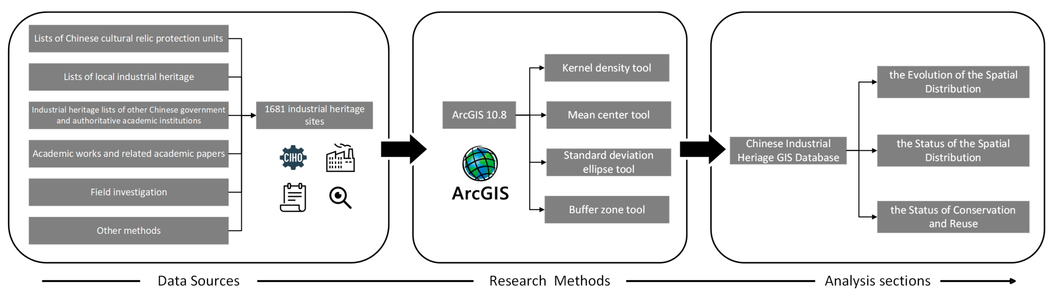
2.1. Data Sources
2.2. Research Methods
2.2.1. Kernel Density Analysis
2.2.2. Mean Center and Standard Ellipse Analysis
2.2.3. Buffer Zone Analysis
3. Analysis
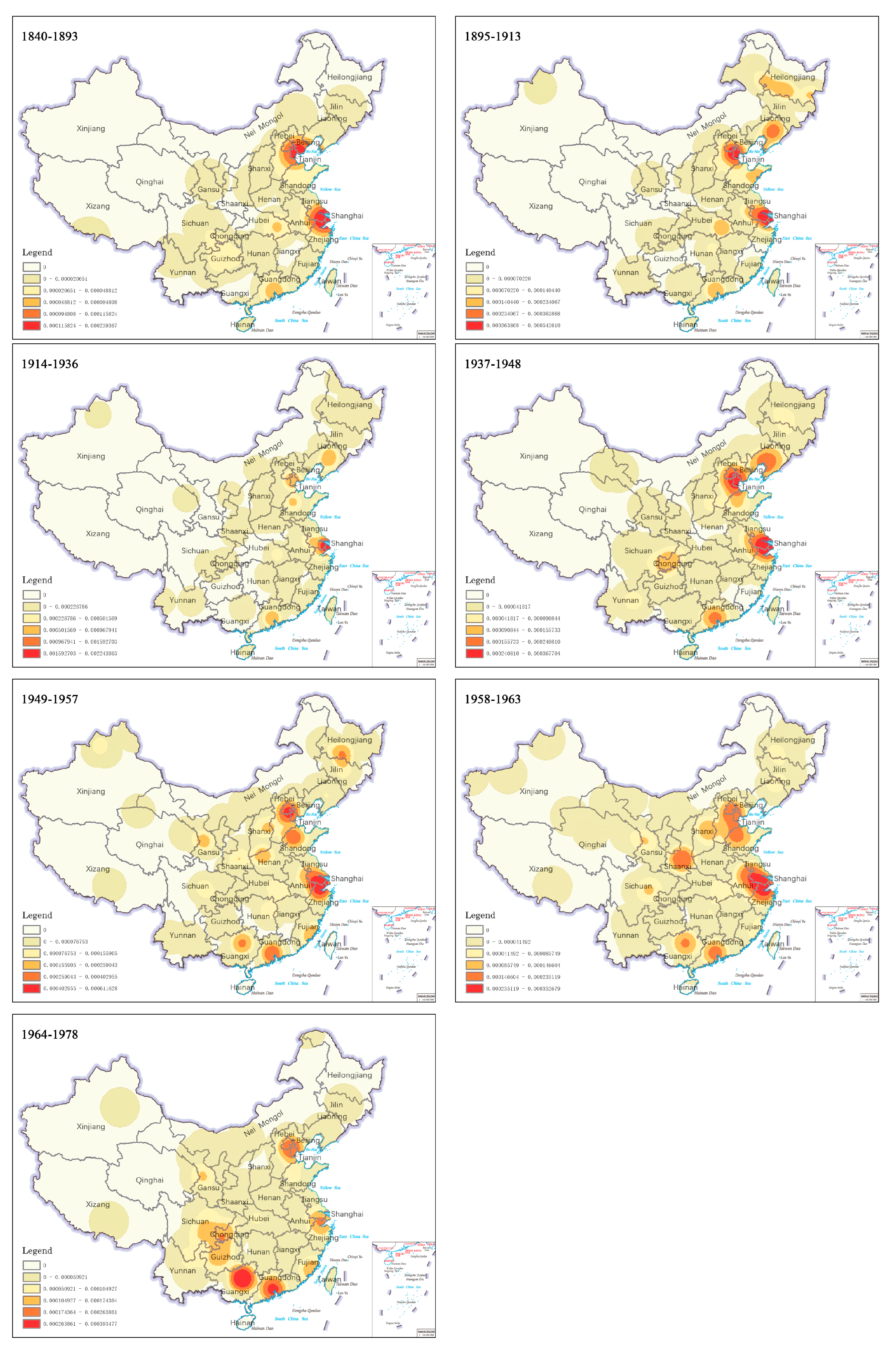
3.1. Analysis of the Evolution of the Spatial Distribution of Industrial Heritage
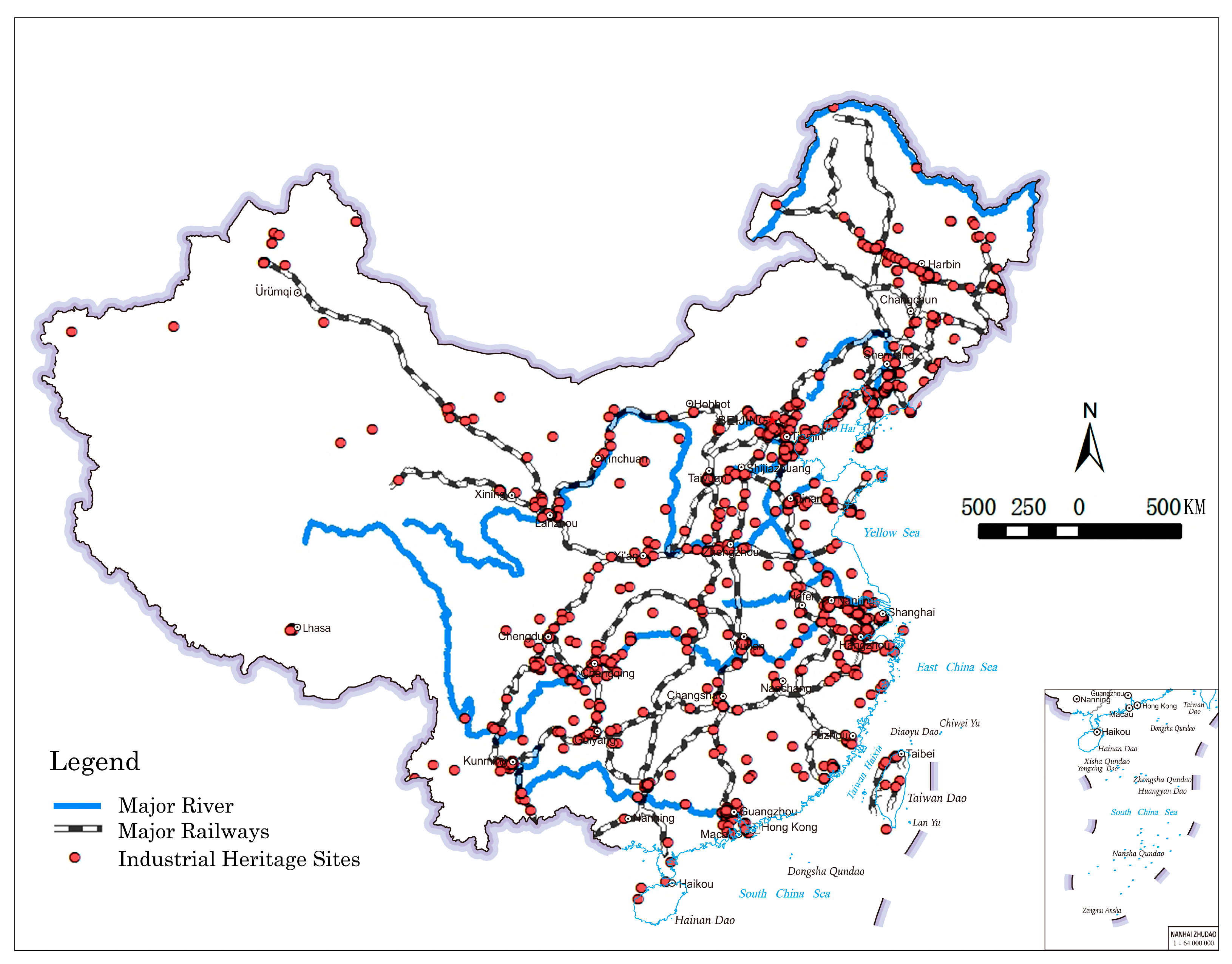
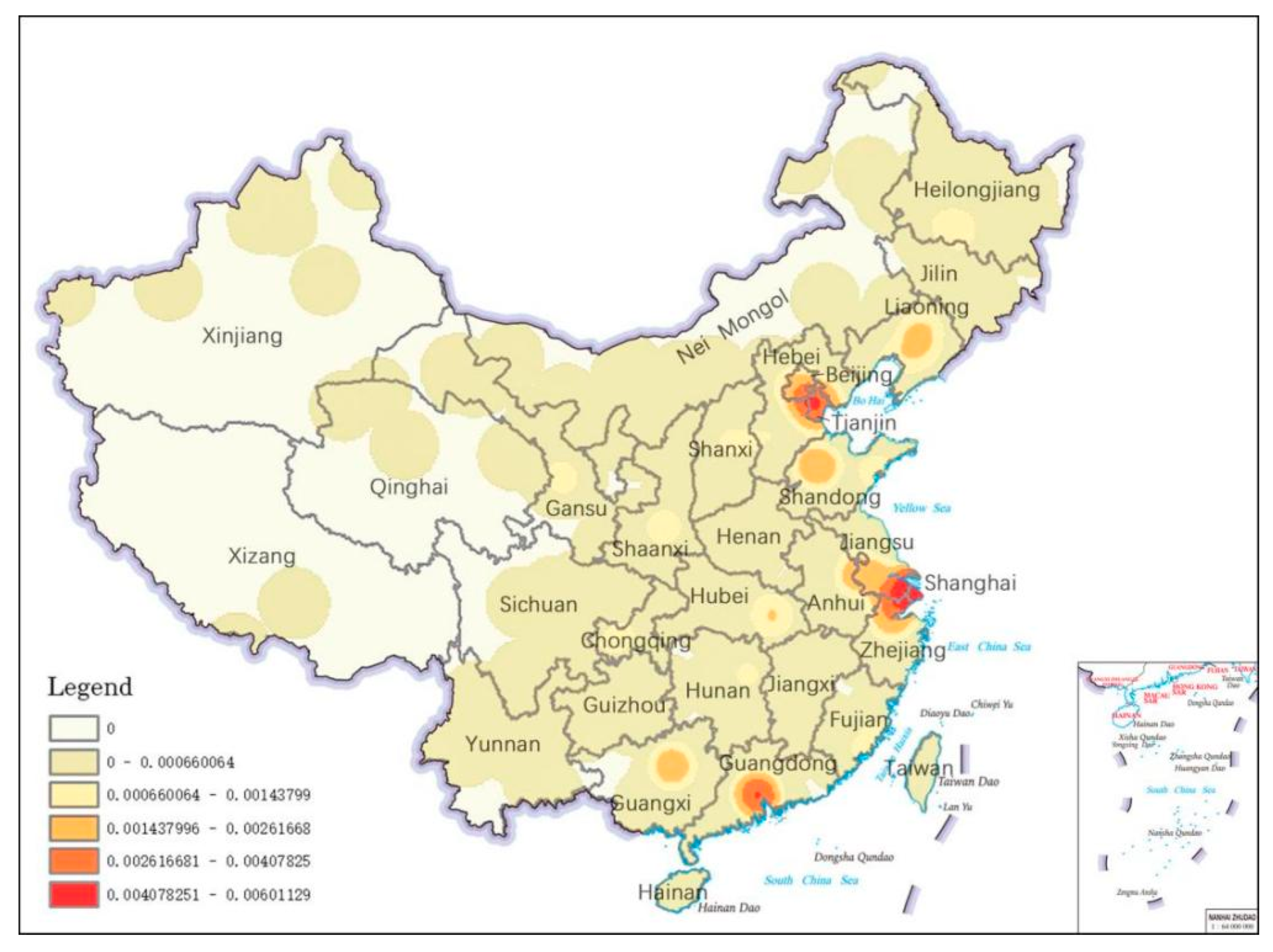
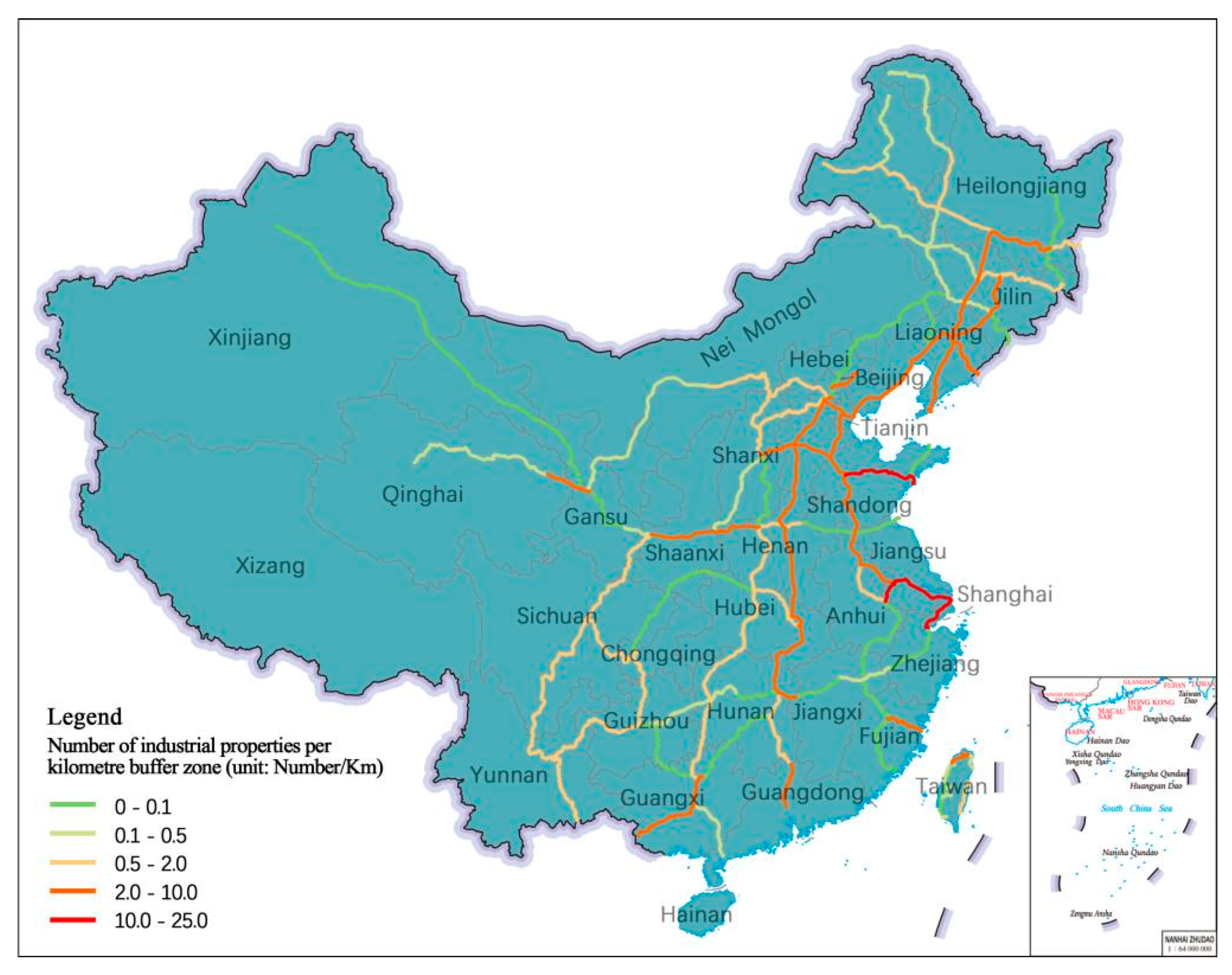
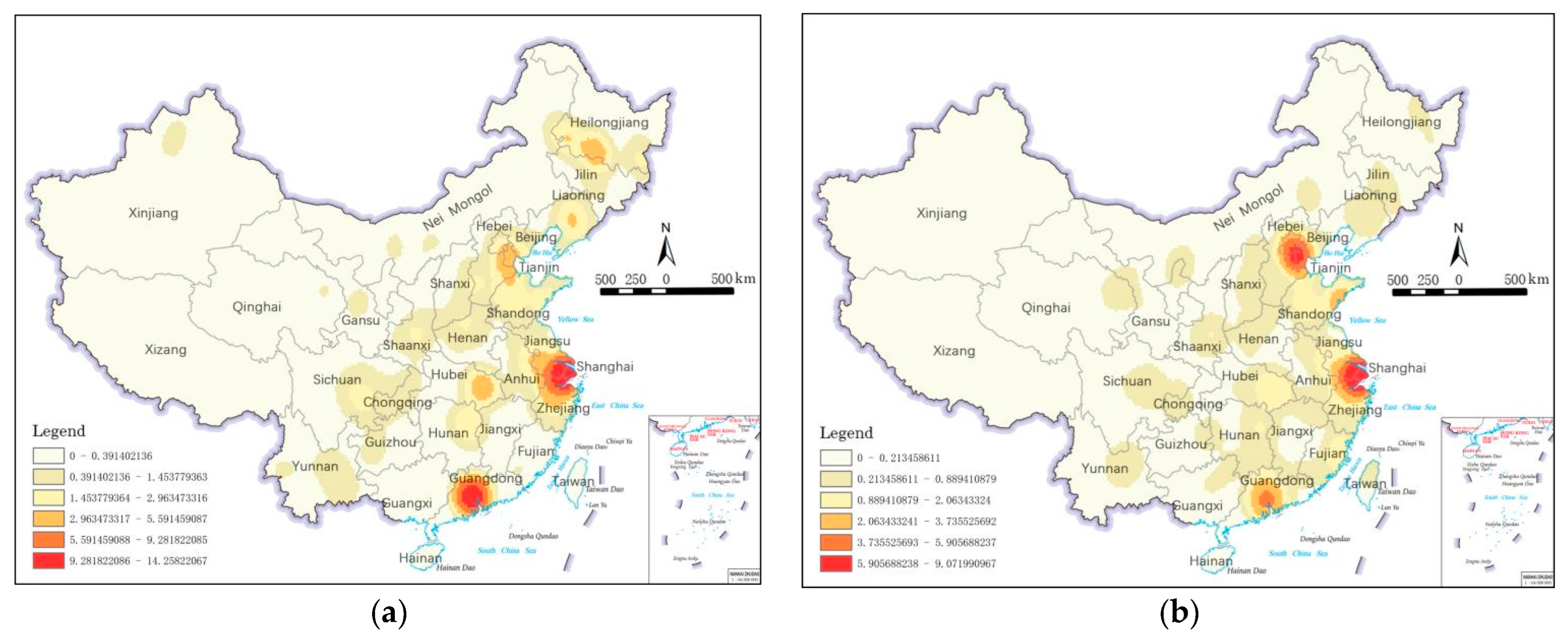
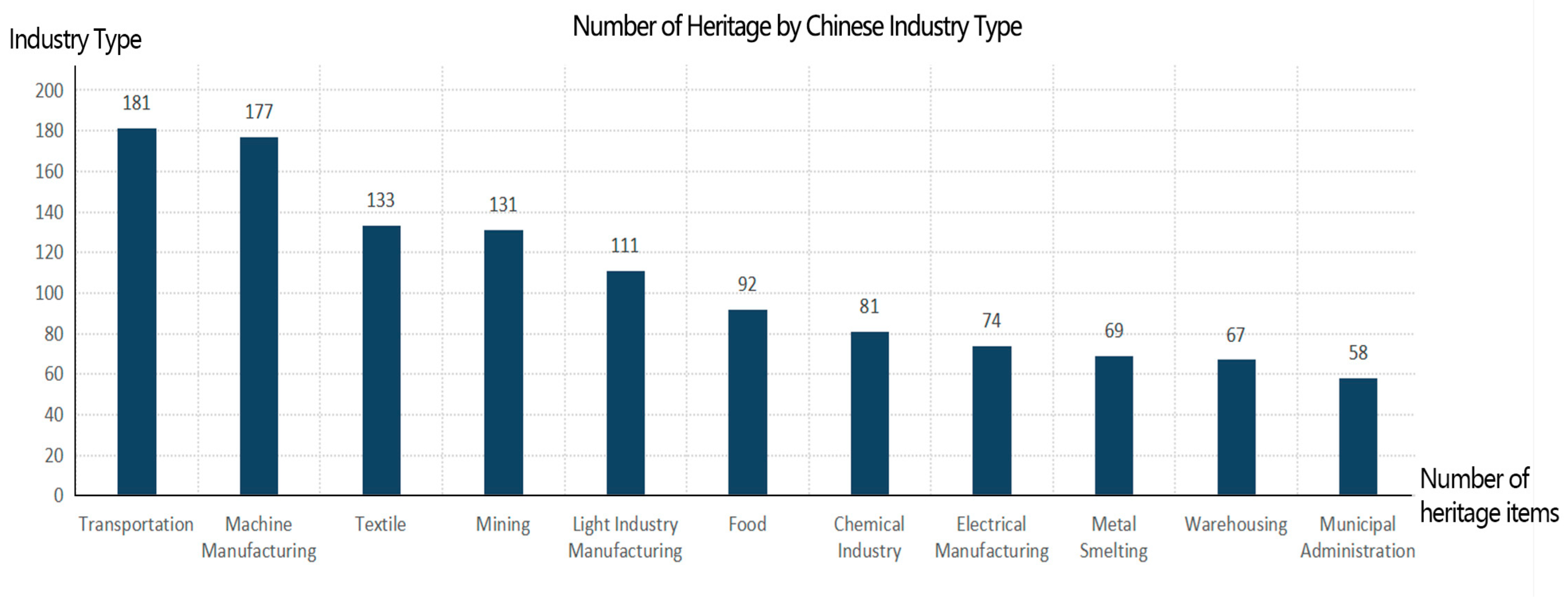
3.2. Analysis of the Status of the Spatial Distribution of Chinese Industrial Heritage
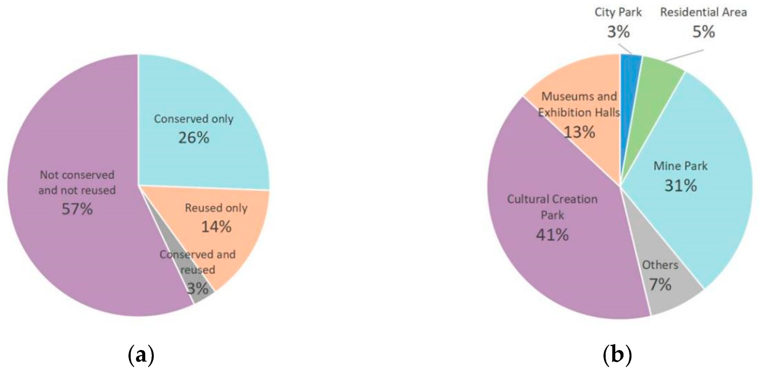
3.3. Analysis of the Status of Conservation and Reuse of Industrial Heritage
4. Results
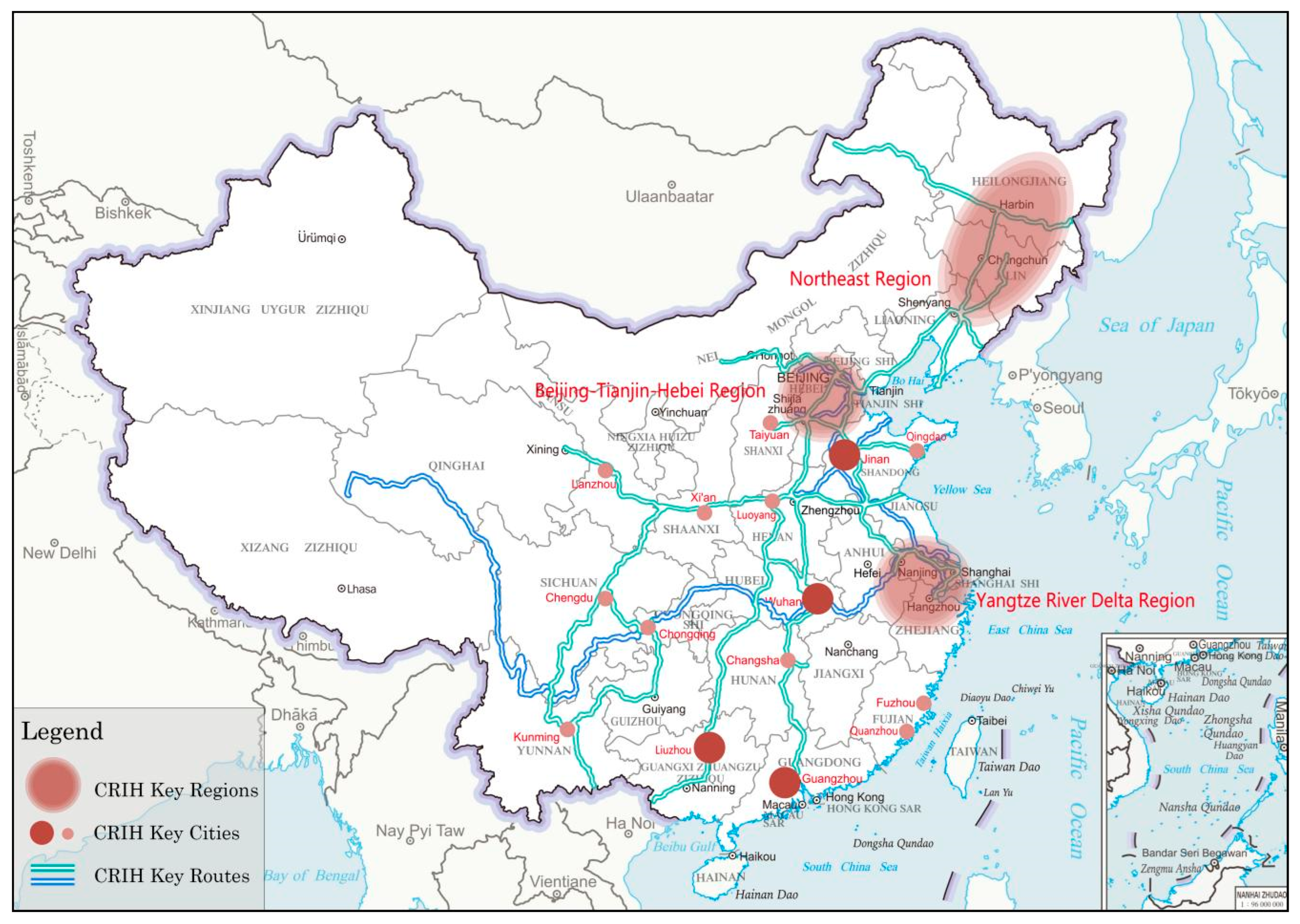
4.1. Construction of the Chinese Route of Industrial Heritage (CRIH)
4.1.1. CRIH Key Sites (Point Elements)
4.1.2. CRIH Key Areas (Surface Elements)
4.1.3. CRIH Key Routes (Line Elements)
5. Discussion
5.1. Thematic Heritage Series of CRIH
5.1.1. Development History Thematic Heritage Series
5.1.2. Industrial Type Thematic Heritage Series
5.2. Multiple Values of CIHGD and CRIH
5.3. Areas for Improvement
6. Conclusions
- The CIHGD was established through extensive data collection. It was used to analyze the changes in the spatial distribution of industrial heritage in China, as well as the current status of conservation and reuse. In the temporal dimension, with the founding of the PRC as the node, China’s industrial construction shows a development trend from accumulation along the coast to dispersal inland; in the spatial dimension, the recent development history of Chinese industry has created the current spatial distribution of industrial heritage, forming three key regions of industrial heritage, 14 key cities of industrial heritage, and important railway and water systems located in eastern China. In addition, as the proportion of both conservation and reuse of China’s industrial heritage is low, there is an urgent need to develop a conservation system at the regional or national level.
- Drawing on the ERIH system framework and based on the results of the CIHGD analysis, the Chinese Route of Industrial Heritage (CRIH) system was established. The system consists of three types of elements: points, surfaces, and routes, which represent important points of industrial heritage, important areas of industrial heritage, and important routes of industrial heritage. Among them, important routes of industrial heritage are both the heritage itself and the connecting bodies of other elements; all three together constitute China’s Route of Industrial Heritage. In addition, based on the relevant attributes of industrial heritage, heritage routes series, such as “development history theme” and “industry type theme”, were derived to expand the dimensions of heritage routes.
- Development of the CRIH is conducive to the holistic conservation of the country’s industrial heritage overall, to harmonize the gaps between different regions, and establish a mutual learning mechanism for conservation. In order to adapt to the national strategy for the protection of cultural heritage and industrial heritage, CRIH connects industrial heritage regionally, forming areas and routes, with the aim of establishing a national-scale system for the protection of industrial heritage in China. Applying the CRIH to tourism planning will help to break down the limitations of administrative divisions, to provide support and basis for the establishment of tourism routes for China’s industrial heritage, allowing visitors to focus more on the different types of industrial heritage and to gain a comprehensive understanding of the unique value of China’s industrial heritage.
Supplementary Materials
Author Contributions
Funding
Data Availability Statement
Acknowledgments
Conflicts of Interest
References
- Liu, B.Y. Roundup of the development of industrial building heritage conservation. Archit. J. 2012, 1, 12–17. [Google Scholar]
- TICCIH. The Nizhny Tagil Charter for the Industrial Heritage. 2003. Available online: https://ticcih.org/about/charter/ (accessed on 3 November 2022).
- COE. Cultural Routes. Available online: https://www.coe.int/en/web/civil-society/cultural-routes (accessed on 20 November 2022).
- Xu, T. Cultural routes: Space corridor for cultural exchange. Landsc. Archit. 2019, 26, 4–5. [Google Scholar]
- Majdoub, W. Analyzing Cultural Routes from a Multidimensional Perspective. Almatourism J. Tour. Cult. Territ. Dev. 2010, 1, 29–37. [Google Scholar]
- ERIH. ERIH’s History and Goals. Available online: https://www.erih.net/about-erih/erihs-history-and-goals (accessed on 3 November 2022).
- Zhang, L.; Zhang, H.J. Wuxi proposal—Focus on industrial heritage conservation during a period of rapid economic development. Archit. Creation. 2006, 8, 195–196. [Google Scholar]
- Liu, B.Y. A review of industrial architecture heritage research in China. New Archit. 2012, 2, 4–9. [Google Scholar]
- Zhang, J.; Cenci, J.; Becue, V.; Koutra, S.; Loakimidis, C.S. Recent evolution of research on industrial heritage in Western Europe and China based on bibliometric analysis. Sustainability 2020, 13, 5348. [Google Scholar] [CrossRef]
- Deng, J.T.; Chen, Y.X. On the legal protection of industrial heritage. China Anc. City 2018, 3, 68–71. [Google Scholar]
- Guo, J.F.; Li, H.P.; Zhang, Y. Industrial heritage preservation method integrating with urban development: The case of Chongqing. New Archit. 2016, 3, 19–24. [Google Scholar]
- Hu, W.; Lei, J.Y. Renewal strategies for industrial heritage protection from the perspective of elasticity: Take the Chongqing special steel Plant as an example. China Anc. City 2022, 36, 49–54. [Google Scholar]
- Dou, G.L.; Bai, X.; Pang, L.B.; Zhang, L. Big air Shougang: Integrating the adaptive reuse of industrial heritage with Olympic venue design. Archit. J. 2021, Z1, 42–47. [Google Scholar]
- Xie, Y.; Liu, Y.; Zhang, J. Application of big-data auxiliary decision technology in cultural heritage revitalization projects: The case of the industrial heritage area of big Taoxichuan area in Jingdezhen. New Archit. 2021, 3, 67–71. [Google Scholar]
- Kuban, N.; Pretelli, M. Industrial Heritage Assessment and Guidelines for the Architectural Conservation of Hydroelectric Plants. Int. J. Archit. Herit. 2021, 15, 1526–1546. [Google Scholar] [CrossRef]
- Cho, M.; Shin, S. Conservation or economization? Industrial heritage conservation in Incheon, Korea. Habitat Int. 2014, 41, 69–76. [Google Scholar] [CrossRef]
- Li, Q.G.; Guo, S.Z.; Xu, Z.M. Temporal and spatial patterns of modern industrial Heritage in China: Considering the national key protection units of cultural relics. S. Archit. 2022, 7, 44–54. [Google Scholar]
- Biscione, M.; Danese, M.; Masini, N. A framework for cultural heritage management and research: The Cancellara case study. J. Maps 2018, 14, 576–582. [Google Scholar] [CrossRef]
- Domínguez-Ruíz, V.; Rey-Pérez, J.; Rivero-Lamela, G. Contribution to the Knowledge of Cultural Heritage via a Heritage Information System (HIS). The Case of “La Cultura del Agua” in Valverde de Burguillos, Badajoz (Spain). Sustainability 2020, 12, 1141. [Google Scholar] [CrossRef]
- Bitelli, G.; Gatta, G.; Guccini, A.M.; Zaffagnini, A. GIS and Geomatics for archive documentation of an architectural project: The case of the big Arc of entrance to the Vittorio Emanuele II Gallery of Milan, by Giuseppe Mengoni (1877). J. Cult. Herit. 2019, 38, 204–212. [Google Scholar] [CrossRef]
- Wang, Z.G.; Du, X. Monitoring Natural World Heritage Sites: Optimization of the monitoring system in Bogda with GIS-based multi-criteria decision analysis. Environ. Monit. Assess. 2016, 188, 384. [Google Scholar] [CrossRef]
- Du, X.; Wang, Z.G. Optimizing monitoring locations using a combination of GIS and fuzzy multi criteria decision analysis, a case study from the Tomur World Natural Heritage site. J. Nat. Conserv. 2018, 43, 67–74. [Google Scholar] [CrossRef]
- Campiani, A.; Lingle, A.; Lercari, N. Spatial analysis and heritage conservation: Leveraging 3-D data and GIS for monitoring earthen architecture. J. Cult. Herit. 2019, 39, 166–176. [Google Scholar] [CrossRef]
- Sánchez-Aparicio, L.J.; Masciotta, M.; García-Alvarez, J.; Ramos, L.F.; Oliveira, D.V.; Martín-Jiménez, J.A.; González-Aguilera, D.; Monteiro, P. Web-GIS approach to preventive conservation of heritage buildings. Autom. Constr. 2020, 118, 103304. [Google Scholar] [CrossRef]
- Xiao, Y. Digital protection of Hakka condoms in Longnan based on BIM and 3DGIS. J. Phys. Conf. Ser. 2021, 1881, 022094. [Google Scholar] [CrossRef]
- Tong, M.F.; Li, B.H.; Li, Z. Research on the spatial-temporal distribution and morphological characteristics of ancient settlements in the Luzhong region of China. Land 2022, 11, 1579. [Google Scholar] [CrossRef]
- Li, W.; Jiao, J.P.; Qi, J.W.; Ma, Y.J. The spatial and temporal differentiation characteristics of cultural heritage in the Yellow River Basin. PLoS ONE 2022, 17, e0268921. [Google Scholar] [CrossRef] [PubMed]
- Zhu, M.; Dong, J.F.; Gao, Y.Z. The research on temporal–spatial distribution and morphological characteristics of ancient settlements in the Songhua River Basin. Sustainability 2019, 11, 932. [Google Scholar] [CrossRef]
- Zhang, J.; Sun, H.; Xu, S.; Aoki, N. Analysis of the spatial and temporal distribution and reuse of urban industrial heritage: The case of Tianjin, China. Land 2022, 11, 2273. [Google Scholar] [CrossRef]
- Yan, M.; Li, Q.; Zhang, J. Rethinking Industrial Heritage Tourism Resources in the EU: A Spatial Perspective. Land 2023, 12, 1510. [Google Scholar] [CrossRef]
- Fan, X.; Sun, L. Geographic Distribution Characteristics and Influencing Factors for Industrial Heritage Sites in Italy Based on GIS. Sustainability 2024, 16, 2085. [Google Scholar] [CrossRef]
- Anonymous. Nanjing Industrial Heritage; Nanjing Publishing House: Nanjing, China, 2012. [Google Scholar]
- Jiang, X. Hunan Transportation Cultural Heritage; China Communications Press: Beijing, China, 2012. [Google Scholar]
- Peng, X. Reading Wuhan Industrial Heritage; Wuhan Publishing House: Wuhan, China, 2013. [Google Scholar]
- Luo, G. Searching for China’s “National Protection” Level Industrial Cultural Heritage; Zhejiang University of Commerce and Industry Press: Hangzhou, China, 2013. [Google Scholar]
- Tianjin Hexi Cultural and Literary History Committee. Tianjin Hexi Old Factories; Xianzhuang Book Bureau: Beijing, China, 2014. [Google Scholar]
- Gao, C.; Yan, F. Research on the Heritage of Central Plains Industrial Civilization; China Water & Power Press: Beijing, China, 2016. [Google Scholar]
- Zhu, W.; Liu, B. Survey, Research, and Protection of Chinese Industrial Architectural Heritage (Volume 1); Tsinghua University Press: Beijing, China, 2011. [Google Scholar]
- Zhu, W.; Liu, B. Survey, Research, and Protection of Chinese Industrial Architectural Heritage (Volume 2); Tsinghua University Press: Beijing, China, 2012. [Google Scholar]
- Zhu, W.; Liu, B. Survey, Research, and Protection of Chinese Industrial Architectural Heritage (Volume 3); Tsinghua University Press: Beijing, China, 2013. [Google Scholar]
- Zhu, W.; Liu, B. Survey, Research, and Protection of Chinese Industrial Architectural Heritage (Volume 4); Tsinghua University Press: Beijing, China, 2014. [Google Scholar]
- Zhu, W.; Liu, B. Survey, Research, and Protection of Chinese Industrial Architectural Heritage (Volume 5); Tsinghua University Press: Beijing, China, 2015. [Google Scholar]
- Zhu, W.; Liu, B. Survey, Research, and Protection of Chinese Industrial Architectural Heritage (Volume 6); Tsinghua University Press: Beijing, China, 2016. [Google Scholar]
- Wang, J. Materials for the History of Modern Chinese Industry (Volume II); Science Press: Beijing, China, 1957. [Google Scholar]
- Li, Z. History of Chinese Railways: 1874–1949; Shantou University Press: Guangdong, China, 1994. [Google Scholar]
- Jin, S.; Xu, W. The Development History of Chinese Railways; China Railway Publishing House: Beijing, China, 1986. [Google Scholar]
- Compiled by Shanghai Municipal Cultural Relics Management Committee. A Documentary of Shanghai’s Industrial Heritage; Shanghai Jiao Tong University Press: Shanghai, China, 2009. [Google Scholar]
- Xu, Z. Fifty Years of Chinese Railways Since 1949; China Railway Publishing House: Beijing, China, 1999. [Google Scholar]
- Li, S. A Preliminary Research about Informatization Survey and Measurement of Historical Buildings Based on BIM Technology Under the Background of Informatization Survey and Measurement; Tianjin University: Tianjin, China, 2014. [Google Scholar]
- Qian, Y.; Ren, P.; Zhang, Z. German-Occupied Qingdao Industrial Heritage and Qingdao’s Urban Historical Landscape. Ind. Constr. 2014, 44, 22–25. [Google Scholar]
- Bai, Q. Rust and Rusted Memories: Tracing China’s Industrial Heritage; China Workers Publishing House: Beijing, China, 2016. [Google Scholar]
- Wang, J. China’s Early Modern Industrial History Data; Science Press: Beijing, China, 1957. [Google Scholar]
- Xu, S.B.; Lai, S.X.; Liu, J.; Aoki, N. A research on historical stages of urban industrial development in China. Architecture 2017, 6, 40–47. [Google Scholar]
- Zhu, C.S. The History of Modern Chinese Industry; Chongqing Press: Chongqing, China, 1989. [Google Scholar]
- Dong, J.H. History of Urban Construction in China, 3rd ed.; China Architecture & Building Press: Beijing, China, 2004. [Google Scholar]
- Xu, Y.W.; Chen, X. The Impact of the Third line Construction on China’s Industrial Economy and Urbanization. Contemp. China Hist. Stud. 2015, 22, 81–92. [Google Scholar]
- Wang, C.; He, Y. Visualization analysis of China’s industrial heritage. China Anc. City 2019, 9, 22–30. [Google Scholar]
- Jiang, C.Q. On the Construction of the Industrial System and the National Economic System from 1949 to 1978. Stud. Mao Zedong Deng Xiaoping Theor. 2022, 2, 48–56+109. [Google Scholar]
- Silverman, B.W.; Smoothing, S. The equivalent variable kernel method. Ann. Stat. 1984, 12, 898–916. [Google Scholar] [CrossRef]
- Liu, R.; Hu, W.; Wang, H.; Wu, C.; He, J. The road network evolution of Guangzhou-Foshan metropolitan area based on kernel density estimation. Sci. Geogr. Sin. 2011, 31, 81–86. [Google Scholar]
- Zhao, L.; Zhao, Z. Projecting the spatial variation of economic based on the specific ellipses in China. Sci. Geogr. Sin. 2014, 34, 979–986. [Google Scholar]
- Wu, H. Problem of buffer zone construction in GIS. Geom. Inf. Sci. Wuhan Univ. 2019, 9, 1674. [Google Scholar]
- Zhou, Z. State and Society: A Study of the Changes in Urban Governance Institutions and Legal Systems in the Qing Dynasty; Bashu Book Society: Chengdu, China, 2009; pp. 221–237. [Google Scholar]
- Zhou, H.; Jin, W. Thematic Outline on the History of the Chinese Revolution; Liaoning People’s Publishing House: Shenyang, China, 1998; pp. 15–17. [Google Scholar]
- Wang, H. Verticality and Breakthrough in a Crisis; University of Science and Technology of China Press: Hefei, China, 2009; pp. 93–94. [Google Scholar]
- Fu, B. A Study of the War of Resistance in Eastern Liaoning; Liaoning Nationalities Press: Shenyang, China, 2006; pp. 44–50. [Google Scholar]
- Wen, M. Relocation and agglomeration of Chinese industry. J. Dev. Econ. 2004, 73, 329–347. [Google Scholar] [CrossRef]
- Shin, H.B. Urban conservation and revalorisation of dilapidated historic quarters: The case of Nanluoguxiang in Beijing. Cities 2010, 27, S43–S54. [Google Scholar] [CrossRef]
- Verdini, G.; Frassoldati, F.; Nolf, C. Reframing China’s heritage conservation discourse. Learning by testing civic engagement tools in a historic rural village. Int. J. Herit. Stud. 2017, 23, 317–334. [Google Scholar] [CrossRef]
- Zhang, X. Conversation on saving historical communities: A participatory renewal and preservation platform. IOP Conf. Ser. Mater. Sci. Eng. 2017, 245, 082053. [Google Scholar] [CrossRef]
- GBT4753-1984; National Economic Industry Classification. National Bureau of Statistics: Beijing, China, 1984.
- Zhao, M. Some data about the position of textile industry in modern industry. J. China Text. Univ. 1994, 3, 140–147. [Google Scholar]
- Shen, J.; Li, L. From industry wasteland to Green Park: The landscape renovation of carl alexander mine park. Landsc. Archit. 2014, 1, 136–141. [Google Scholar]


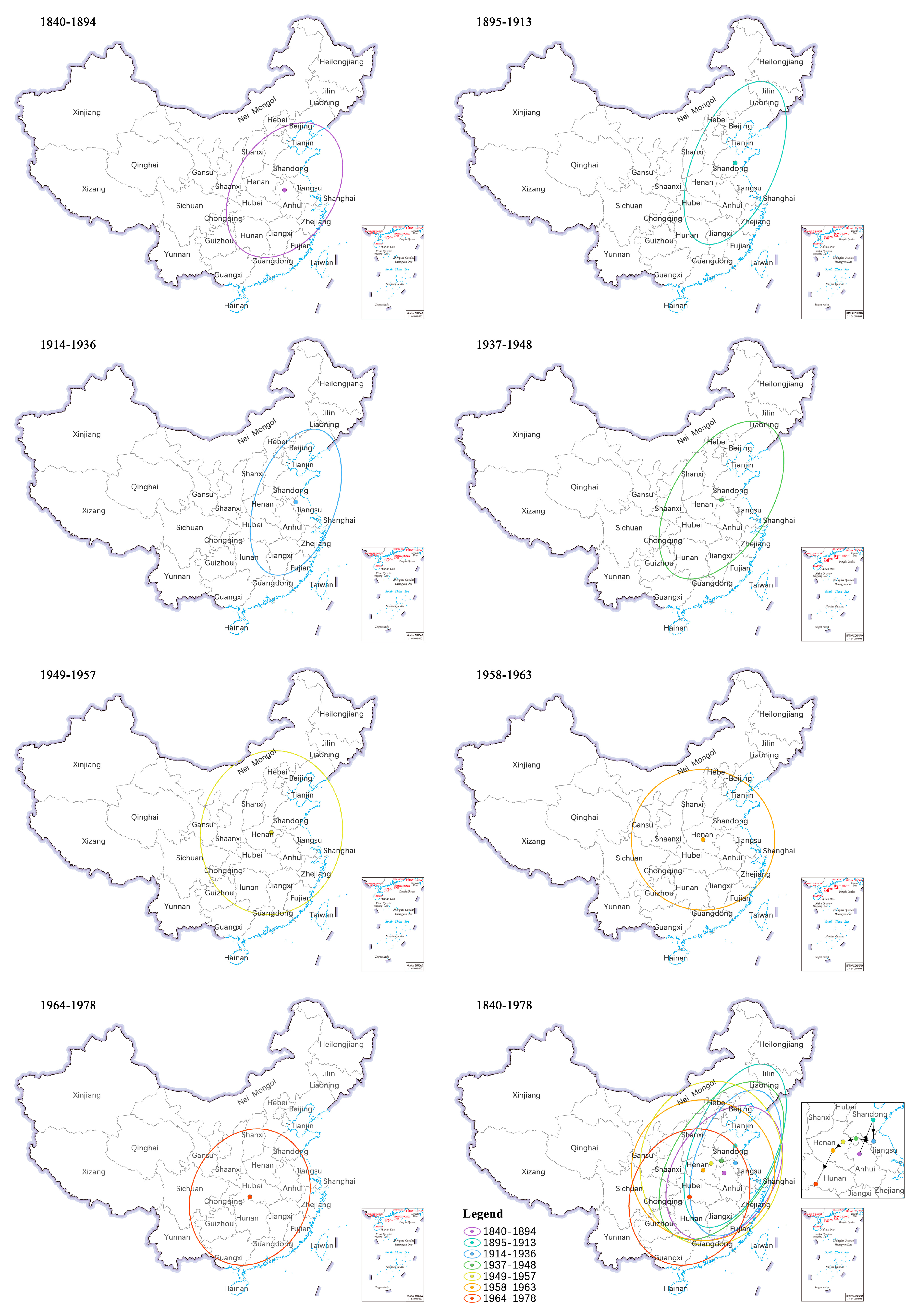
| Historic Stage | Mean Center Coordinates | Directional Angle | Long Axis (km) | Short Axis (km) | Oblateness | Shape Area (km2) | Moving Direction | Moving Distance (km) |
|---|---|---|---|---|---|---|---|---|
| 1840–1894 | 102.13° E, 36.64° N | 33.16° | 995.95 | 685.70 | 0.31 | 2,145,333.29 | - | - |
| 1895–1913 | 117.03° E, 40.32° N | 23.10° | 1178.05 | 566.01 | 0.52 | 2,094,592.36 | Northeast | 397.69 |
| 1914–1936 | 117.48° E, 37.98° N | 19.40° | 1031.57 | 549.47 | 0.47 | 1,780,557.33 | Southeast | 233.79 |
| 1937–1948 | 98.48° E, 38.30° N | 32.35° | 1194.72 | 660.75 | 0.45 | 2,479,783.44 | Northwest | 192.57 |
| 1949–1957 | 84.41° E, 37.94° N | 8.62° | 1116.01 | 963.35 | 0.14 | 3,377,385.80 | Southwest | 145.12 |
| 1958–1963 | 73.50° E, 37.01° N | 90.01° | 974.36 | 955.00 | 0.02 | 2,923,143.34 | Southwest | 143.57 |
| 1964–1978 | 54.94° E, 30.38° N | 23.75° | 947.74 | 795.47 | 0.16 | 2,368,318.73 | Southwest | 407.74 |
| Categories | Specific Items |
|---|---|
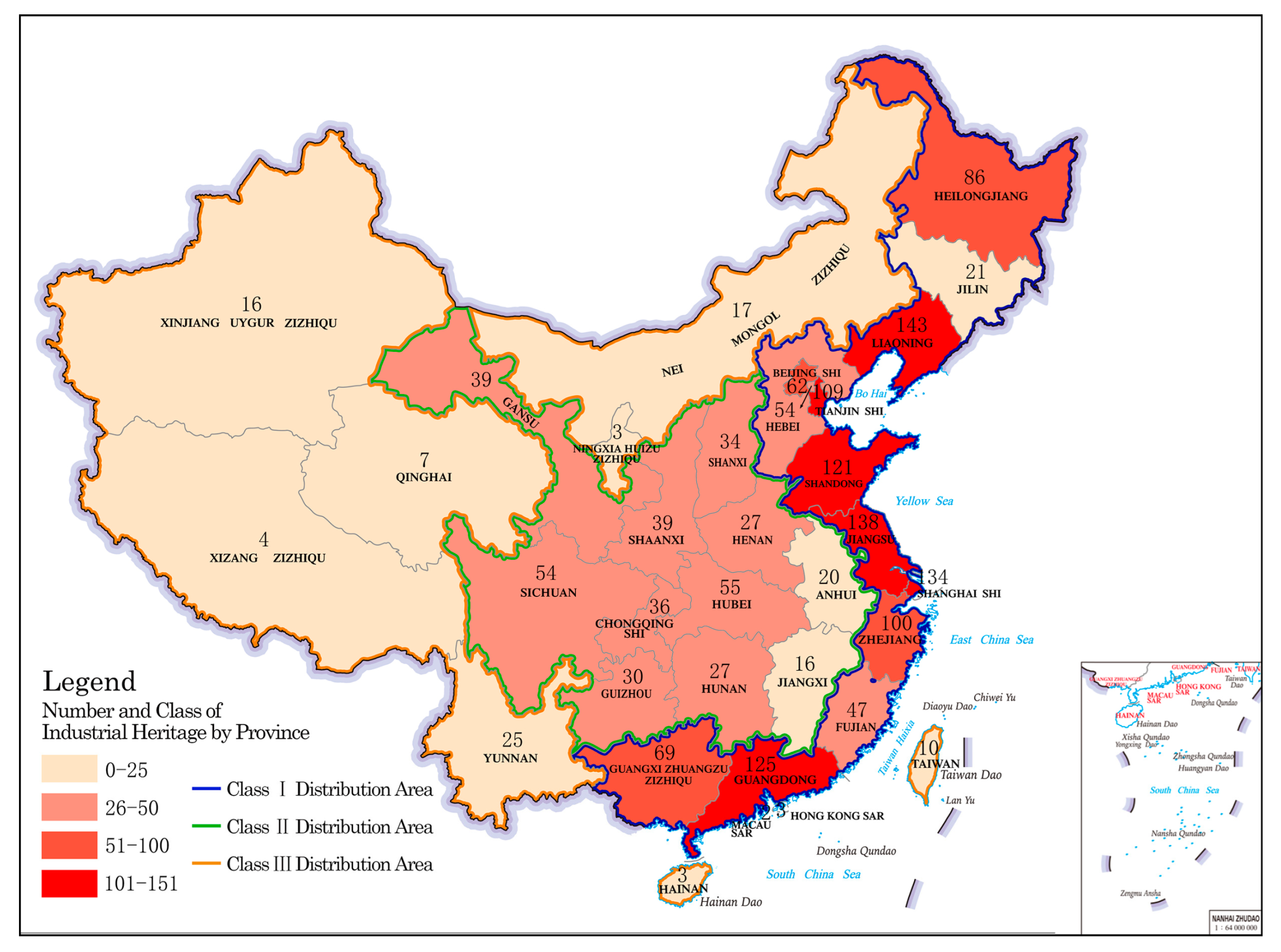
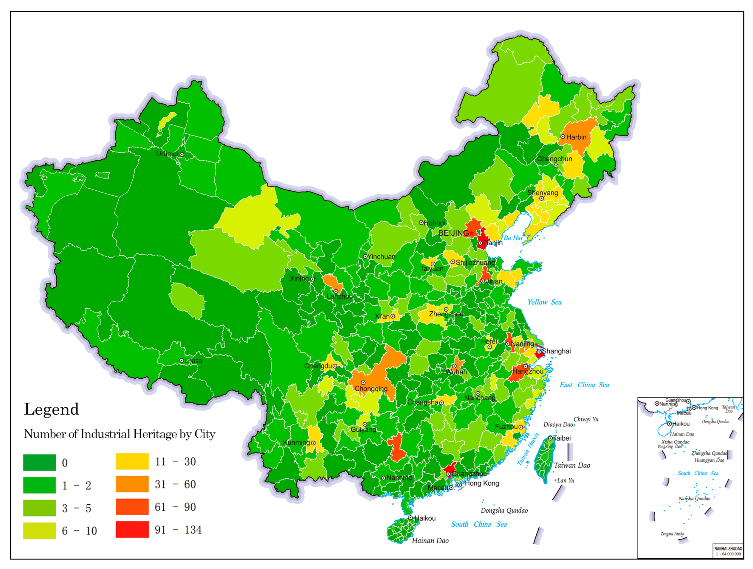
| Industrial heritage key regions (3) | Northeast Region (Heilongjiang, Jilin, Liaoning) 249 items, major cities: Harbin (38 items), Dalian (26 items), Shenyang (19 items), etc. |
| Beijing–Tianjin–Hebei Region (Beijing, Tianjin, Hebei) 226 items, major cities: Tianjin (109 items), Beijing (62 items), Shijiazhuang (18 items), etc. | |
| Yangtze River Delta Region (Shanghai, Jiangsu, Zhejiang) 272 items, major cities: Shanghai (134 items), Hangzhou (71 items), Nanjing (60 items), Wuxi (31 items), Suzhou (24 items), etc. | |
| Industrial heritage key cities (15) | Guangzhou (116 items), Jinan (70 items), Liuzhou (65 items), Wuhan (41 items), Chongqing (36 items), Lanzhou (29 items), Qingdao (29 items), Xi’an (27 items), Quanzhou (27 items), Taiyuan (23 items), Changsha (15 items), Fuzhou (14 items), Kunming (14 items), Chengdu (13 items), and Luoyang (12 items). |
| Categories | Specific Items |
|---|---|
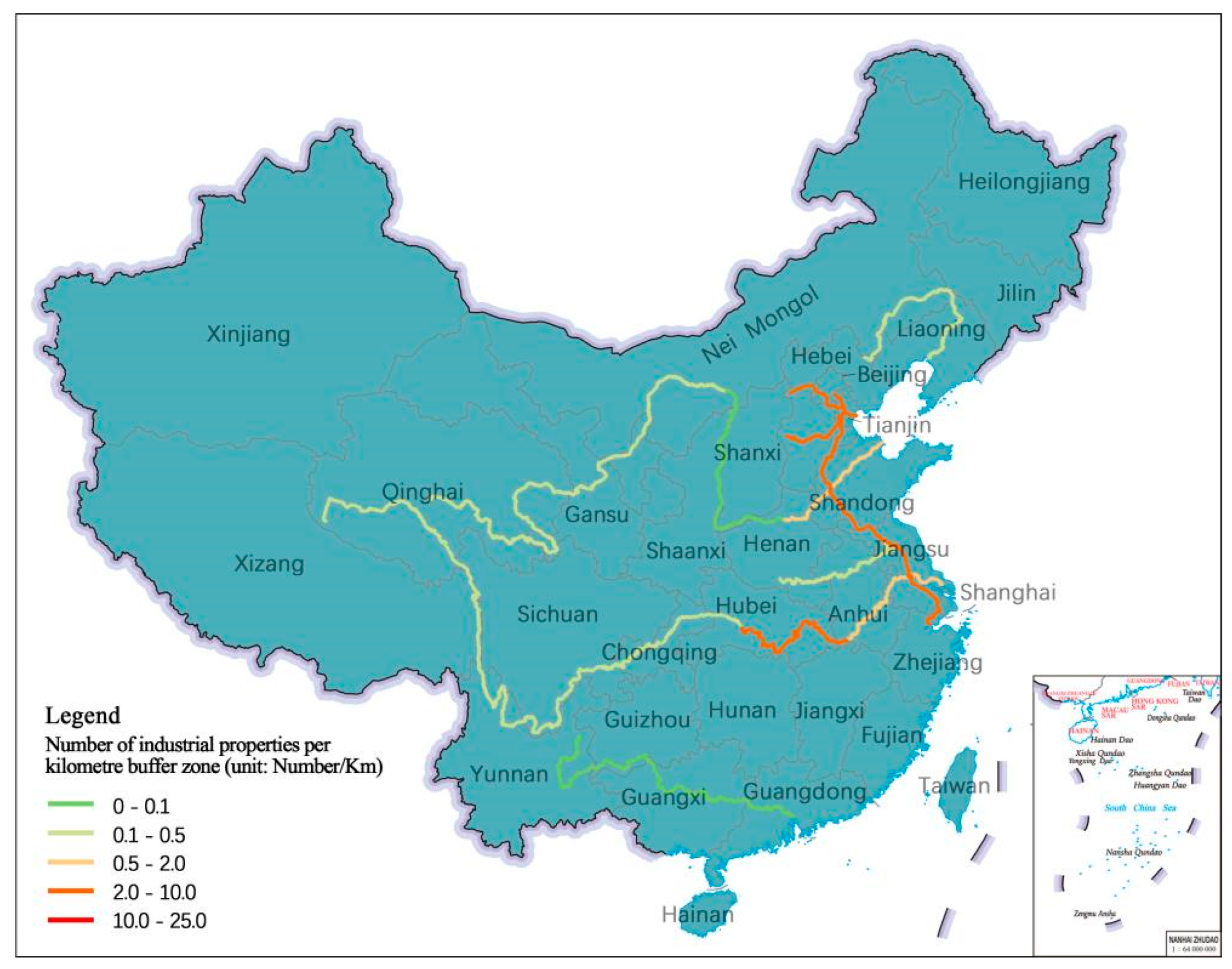
| Important railways | National railways: Middle East railway, Jingguang railway, Jiaoji railway, Jinpu railway, Jingfeng railway, Longhai railway, JiaoLiu railway, Southwest Third Line railway; Regional railways: Shenji railway, Shendan railway, Beijing–Bao railway, Shide railway, Shitai railway, Huning railway, Huhang railway, Ningwu railway |
| Important rivers | Haihe River, Beijing–Hangzhou Grand Canal, Lower Yellow River, Yangtze River |
Disclaimer/Publisher’s Note: The statements, opinions and data contained in all publications are solely those of the individual author(s) and contributor(s) and not of MDPI and/or the editor(s). MDPI and/or the editor(s) disclaim responsibility for any injury to people or property resulting from any ideas, methods, instructions or products referred to in the content. |
© 2024 by the authors. Licensee MDPI, Basel, Switzerland. This article is an open access article distributed under the terms and conditions of the Creative Commons Attribution (CC BY) license (https://creativecommons.org/licenses/by/4.0/).
Share and Cite
Zhang, J.; Zhuo, L.; Sun, H.; Wang, Y.; Wei, H.; Xu, S.; Aoki, N. Construction of the Chinese Route of Industrial Heritage Based on Spatial and Temporal Distribution Analysis. Buildings 2024, 14, 1065. https://doi.org/10.3390/buildings14041065
Zhang J, Zhuo L, Sun H, Wang Y, Wei H, Xu S, Aoki N. Construction of the Chinese Route of Industrial Heritage Based on Spatial and Temporal Distribution Analysis. Buildings. 2024; 14(4):1065. https://doi.org/10.3390/buildings14041065
Chicago/Turabian StyleZhang, Jiahao, Lingchen Zhuo, Hao Sun, Yuanling Wang, Hanbin Wei, Subin Xu, and Nobuo Aoki. 2024. "Construction of the Chinese Route of Industrial Heritage Based on Spatial and Temporal Distribution Analysis" Buildings 14, no. 4: 1065. https://doi.org/10.3390/buildings14041065
APA StyleZhang, J., Zhuo, L., Sun, H., Wang, Y., Wei, H., Xu, S., & Aoki, N. (2024). Construction of the Chinese Route of Industrial Heritage Based on Spatial and Temporal Distribution Analysis. Buildings, 14(4), 1065. https://doi.org/10.3390/buildings14041065