
Conceptual Framework of Information Flow Synchronization Throughout the Building Lifecycle


Abstract
1. Introduction
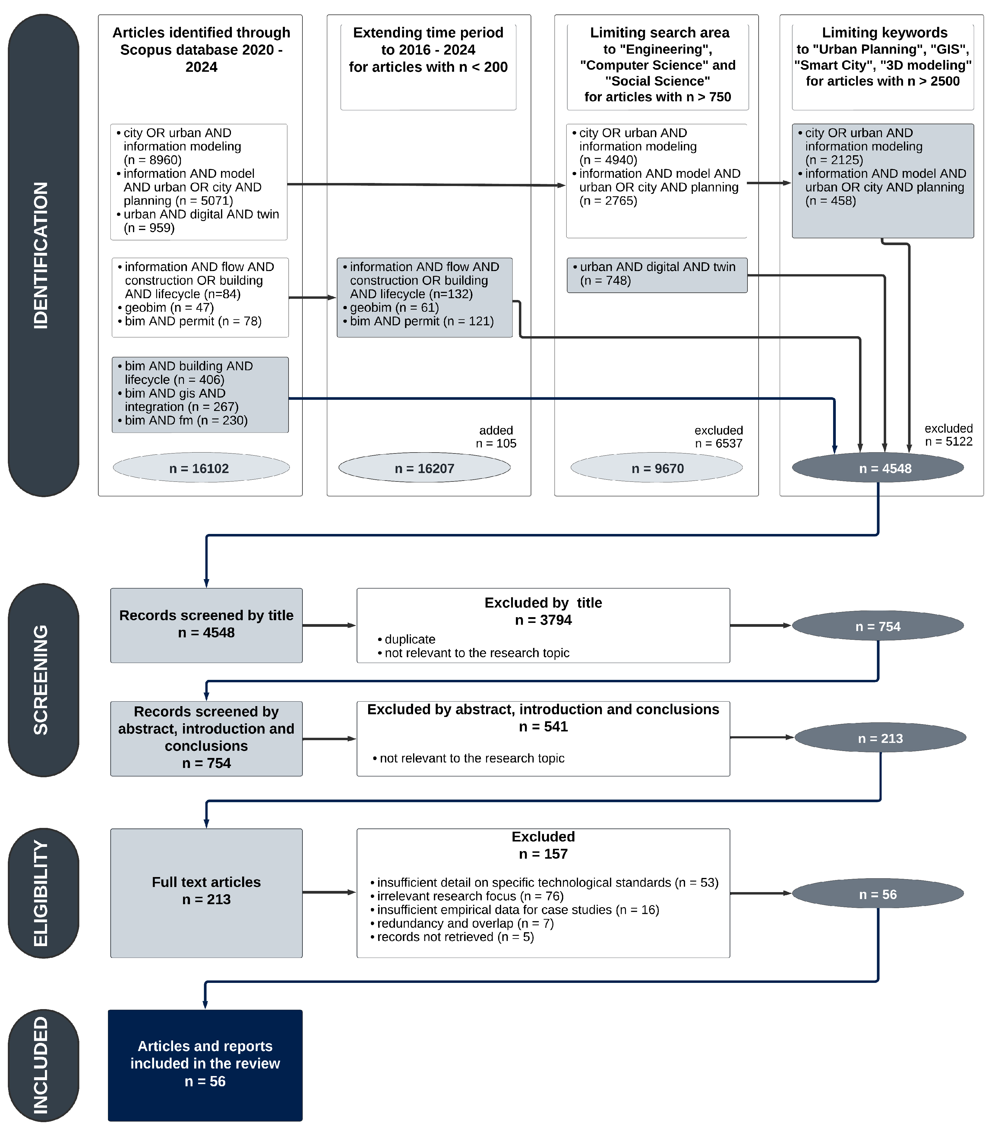
2. Methodology
3. State of the Art in Building Life Cycle Information Flow Research
3.1. Urban Planning
3.2. Design and Permits
3.3. Construction
3.4. Facility Management
3.5. Digital Twins
3.6. Summary of the State of the Art
4. Conceptual Framework
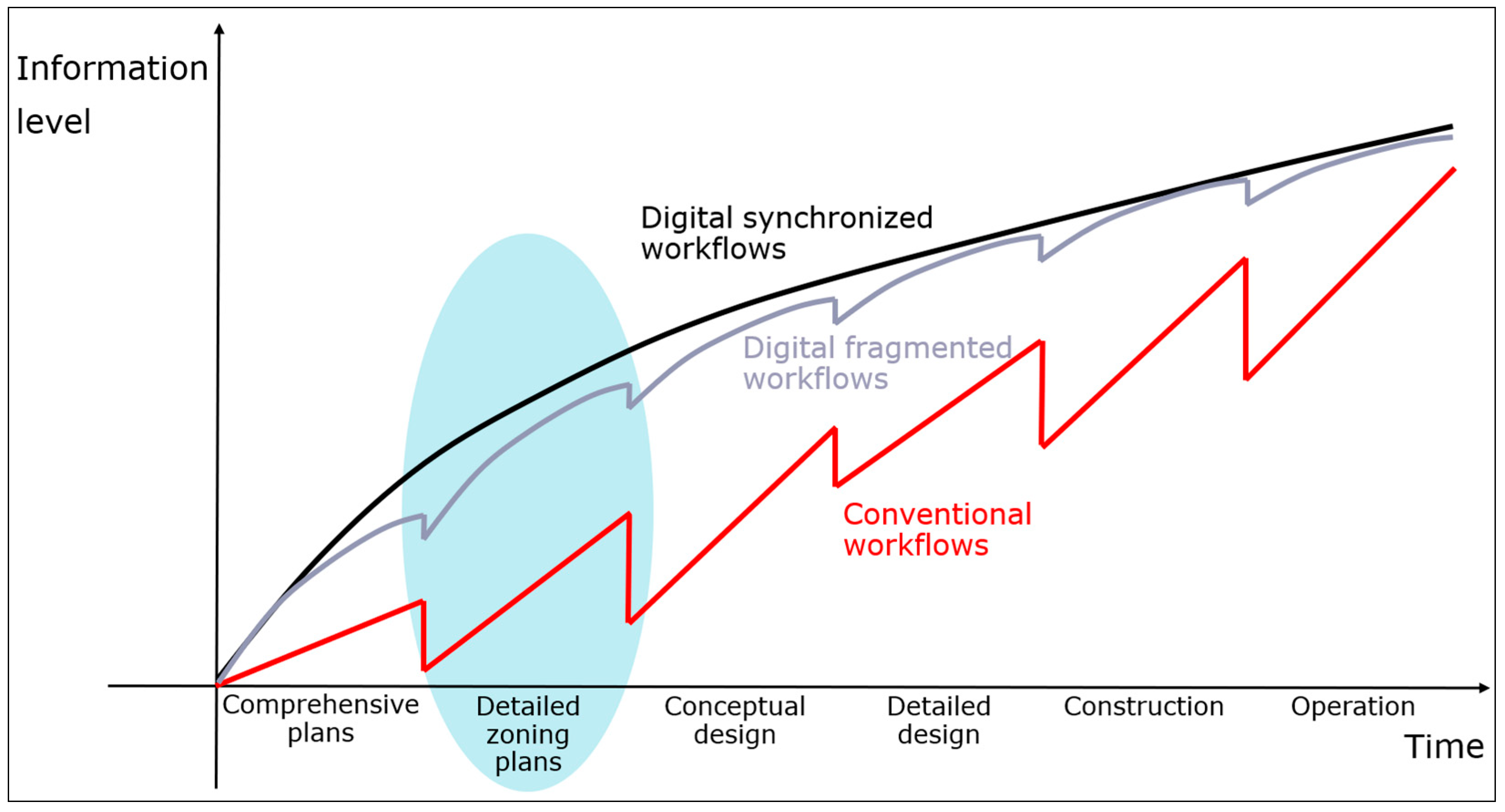
4.1. Disruption of Information Flow
4.2. Research Focus
- RQ1: how can central technical solutions in public sector digital innovation platforms enhance information flow?
- 2.
- RQ2: how should GIS and BIM processes be coordinated throughout the construction lifecycle, and where is their intersection?
- 3.
- RQ3: What changes are needed on the level of governmental information flow management, and how can their impact be measured?
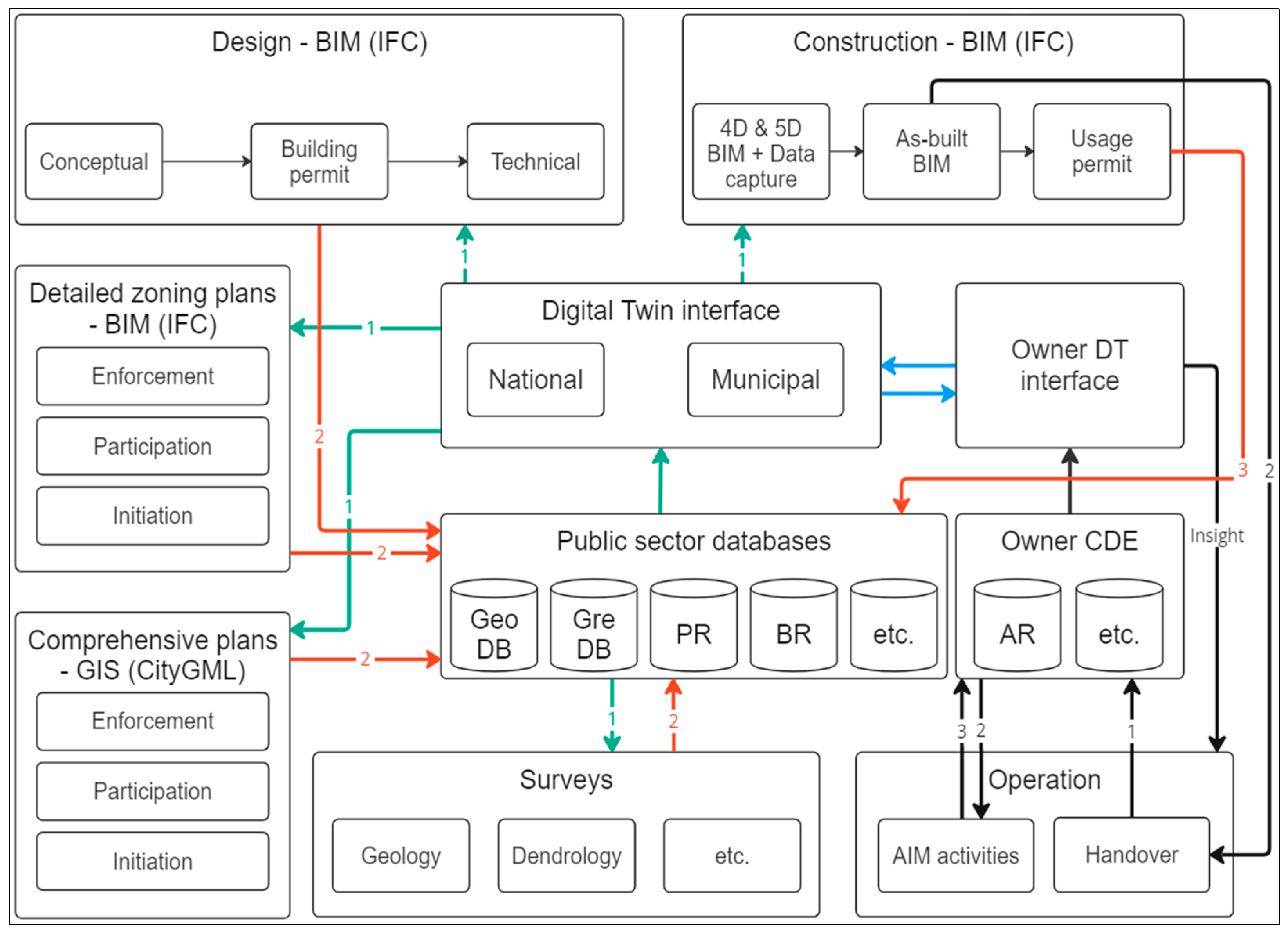
4.3. Information Flow Scheme
5. Discussion
6. Conclusions
Author Contributions
Funding
Data Availability Statement
Conflicts of Interest
References
- Eastman, C.; Lee, J.-M.; Jeong, Y.-S.; Lee, J.-K. Automatic rule-based checking of building designs. Autom. Constr. 2009, 18, 1011–1033. [Google Scholar] [CrossRef]
- Plazza, D.; Röck, M.; Malacarne, G.; Passer, A.; Marcher, C.; Matt, D.T. BIM for public authorities: Basic research for the standardized implementation of BIM in the building permit process. IOP Conf. Ser. Earth Environ. Sci. 2019, 323, 012102. [Google Scholar] [CrossRef]
- Noardo, F.; Malacarne, G. Workshop Report European Spatial Data Research I EUnet4DBP International Workshop on Digital Building Permit DIGITAL BUILDING PERMIT: A STATE OF PLAY. Available online: https://www.eurosdr.net/sites/default/files/uploaded_files/eurosdr_eunet4dbp.pdf (accessed on 5 May 2024).
- Liu, X.; Wang, X.; Wright, G.; Cheng, J.C.P.; Li, X.; Liu, R. A State-of-the-Art Review on the Integration of Building Information Modeling (BIM) and Geographic Information System (GIS). ISPRS Int. J. Geo-Inf. 2017, 6, 53. [Google Scholar] [CrossRef]
- Fonsati, A.; Cosentini, R.M.; Tundo, C.; Osello, A. From Geotechnical Data to GeoBIM Models: Testing Strategies for an Ex-Industrial Site in Turin. Buildings 2023, 13, 2343. [Google Scholar] [CrossRef]
- Zubair, M.U.; Ali, M.; Khan, M.A.; Khan, A.; Hassan, M.U.; Tanoli, W.A. BIM- and GIS-Based Life-Cycle-Assessment Framework for Enhancing Eco Efficiency and Sustainability in the Construction Sector. Buildings 2024, 14, 360. [Google Scholar] [CrossRef]
- Kylili, A.; Georgali, P.-Z.; Christou, P.; Fokaides, P. An integrated building information modeling (BIM)-based lifecycle-oriented framework for sustainable building design. Constr. Innov. 2022, 24, 492–514. [Google Scholar] [CrossRef]
- Ismaeil, E.M.H. Asset Information Model Management-Based GIS/BIM Integration in Facility Management Contract. Sustainability 2024, 16, 2495. [Google Scholar] [CrossRef]
- Eastman, C.M. BIM Handbook: A Guide to Building Information Modeling for Owners, Managers, Designers, Engineers, and Contractors; Wiley: Hoboken, NJ, USA, 2008. [Google Scholar]
- Borrmann, A.; König, M.; Koch, C.; Beetz, J. Building Information Modeling: Why? What? How? In Building Information Modeling; Springer: Cham, Switzerland, 2018. [Google Scholar] [CrossRef]
- Johnson, J.; Motor, T.; North, M. Collaboration, Integrated Information and the Project Lifecycle in Building Design, Construction and Operation. 2004. Available online: https://kcuc.org/wp-content/uploads/2013/11/Collaboration-Integrated-Information-and-the-Project-Lifecycle.pdf (accessed on 5 May 2024).
- Succar, B. Building information modelling framework: A research and delivery foundation for industry stakeholders. Autom. Constr. 2009, 18, 357–375. [Google Scholar] [CrossRef]
- Liu, Z.; Liu, Y.; Osmani, M. Integration of Smart Cities and Building Information Modeling (BIM) for a Sustainability Oriented Business Model to Address Sustainable Development Goals. Buildings 2024, 14, 1458. [Google Scholar] [CrossRef]
- El-Mekawy, M.; Östman, A.; Hijazi, I. A Unified Building Model for 3D Urban GIS. ISPRS Int. J. Geo-Inf. 2012, 1, 120–145. [Google Scholar] [CrossRef]
- Page, M.J.; McKenzie, J.E.; Bossuyt, P.M.; Boutron, I.; Hoffmann, T.C.; Mulrow, C.D.; Shamseer, L.; Tetzlaff, J.M.; Akl, E.A.; Brennan, S.E.; et al. The PRISMA 2020 statement: An updated guideline for reporting systematic reviews Systematic reviews and Meta-Analyses. BMJ 2021, 372, 71. [Google Scholar] [CrossRef] [PubMed]
- Kalogianni, E.; Dimopoulou, E.; Thompson, R.J.; Lemmen, C.; Ying, S.; van Oosterom, P. Development of 3D spatial profiles to support the full lifecycle of 3D objects. Land Use Policy 2020, 98, 104177. [Google Scholar] [CrossRef]
- ISO 19152-1:2024; Geographic Information—Land Administration Domain Model (LADM)—Part 1: Generic Conceptual Model. International Organization for Standardization: Geneva, Switzerland, 2024. Available online: https://www.iso.org/standard/81263.html (accessed on 12 May 2024).
- ISO/DIS 19152-5; Geographic Information—Land Administration Domain Model (LADM)—Part 5: Spatial Plan Information. International Organization for Standardization: Geneva, Swizerland. Available online: https://www.iso.org/standard/81267.html (accessed on 12 May 2024).
- ISO 19152-6; Geographic Information—Land Administration Domain Model (LADM)—Part 6: Implementation Aspects. International Organization for Standardization: Geneva, Switzerland. Available online: https://committee.iso.org/sites/tc211/home/projects/projects---complete-list/iso-19152-6.html (accessed on 26 May 2024).
- Tomić, H.; Ivić, S.M.; Roić, M.; Šiško, J. Developing an efficient property valuation system using the LADM valuation information model: A Croatian case study. Land Use Policy 2021, 104, 105368. [Google Scholar] [CrossRef]
- ISO 16739-1:2024; Industry Foundation Classes (IFC) for Data Sharing in the Construction and Facility Management Industries —Part 1: Data Schema. International Organization for Standardization: Geneva, Switzerland, 2024. Available online: https://www.iso.org/standard/84123.html (accessed on 26 May 2024).
- EUBIM Task Group. Handbook for the Introduction of Building Information Modelling by the European Public Sector Strategic Action for Construction Sector Performance: Driving Value, Innovation and Growth; EUBIM Task Group: Brussels, Belgium, 2017; Available online: https://www.eubim.eu/downloads/EU_BIM_Task_Group_Handbook_FINAL.PDF (accessed on 27 May 2024).
- Guler, D. Implementation of 3D spatial planning through the integration of the standards. Trans. GIS 2023, 27, 2252–2277. [Google Scholar] [CrossRef]
- CityGML—Open Geospatial Consortium. Available online: https://www.ogc.org/standard/citygml/ (accessed on 26 May 2024).
- Ledoux, H.; Ohori, K.A.; Kumar, K.; Dukai, B.; Labetski, A.; Vitalis, S. CityJSON: A compact and easy-to-use encoding of the CityGML data model. Open Geospat. Data Softw. Stand. 2019, 4, 4. [Google Scholar] [CrossRef]
- Van Berlo, L.; Dijkmans, T.; Stoter, J. Experiment for Integrating Dutch 3d Spatial Planning and BIM for Checking Building Permits. Available online: http://www.ruimtelijkeplannen.nl (accessed on 26 May 2024).
- Nummi, P.; Staffans, A.; Helenius, O. Digitalizing planning culture: A change towards information model-based planning in Finland. J. Urban Manag. 2023, 12, 44–56. [Google Scholar] [CrossRef]
- Kalogianni, E.; van Oosterom, P.; Dimopoulou, E.; Lemmen, C. 3D Land Administration: A Review and a Future Vision in the Context of the Spatial Development Lifecycle. ISPRS Int. J. Geo-Inf. 2020, 9, 107. [Google Scholar] [CrossRef]
- Chowdhury, M.; Hosseini, M.R.; Edwards, D.J.; Martek, I.; Shuchi, S. Comprehensive analysis of BIM adoption: From narrow focus to holistic understanding. Autom. Constr. 2024, 160, 105301. [Google Scholar] [CrossRef]
- Safour, R.; Ahmed, S.; Zaarour, B. BIM Adoption around the World. Int. J. BIM Eng. Sci. 2021, 4, 31–44. [Google Scholar] [CrossRef]
- Fauth, J.; Bloch, T.; Noardo, F.; Nisbet, N.; Kaiser, S.-B.; Gade, P.N.; Tekavec, J. Taxonomy for building permit system—Organizing knowledge for building permit digitalization. Adv. Eng. Inform. 2024, 59, 102312. [Google Scholar] [CrossRef]
- Ullah, K.; Raitviir, C.; Lill, I.; Witt, E. BIM adoption in the AEC/FM industry—The case fo issuing building permits. Int. J. Strateg. Prop. Manag. 2020, 24, 400–413. [Google Scholar] [CrossRef]
- Noardo, F.; Wu, T.; Ohori, K.A.; Krijnen, T.; Stoter, J. IFC models for semi-automating common planning checks for building permits. Autom. Constr. 2022, 134, 104097. [Google Scholar] [CrossRef]
- Ismail, A.S.; Ali, K.N.; Iahad, N.A.; Kassem, M.A.; Al-Ashwal, N.T. BIM-Based Automated Code Compliance Checking System in Malaysian Fire Safety Regulations: A User-Friendly Approach. Buildings 2023, 13, 1404. [Google Scholar] [CrossRef]
- Beach, T.; Yeung, J.; Nisbet, N.; Rezgui, Y. Digital approaches to construction compliance checking: Validating the suitability of an ecosystem approach to compliance checking. Adv. Eng. Inform. 2024, 59, 102288. [Google Scholar] [CrossRef]
- Andrich, W.; Daniotti, B.; Pavan, A.; Mirarchi, C. Check and Validation of Building Information Models in Detailed Design Phase: A Check Flow to Pave the Way for BIM Based Renovation and Construction Processes. Buildings 2022, 12, 154. [Google Scholar] [CrossRef]
- Riddell, T. Bad Construction Data Costs Industry $1.8 Trillion Worldwide—MSUITE. Available online: https://www.msuite.com/bad-construction-data-costs-industry-1-8-trillion-worldwide/ (accessed on 15 May 2024).
- Chen, Y.; Huang, D.; Liu, Z.; Osmani, M.; Demian, P. Construction 4.0, Industry 4.0, and Building Information Modeling (BIM) for Sustainable Building Development within the Smart City. Sustainability 2022, 14, 10028. [Google Scholar] [CrossRef]
- Xu, S.; Luo, H. The information-related time loss on construction sites: A case study on two sites. Int. J. Adv. Robot. Syst. 2014, 11, 128. [Google Scholar] [CrossRef]
- Barlish, K.; Sullivan, K. How to measure the benefits of BIM—A case study approach. Autom. Constr. 2012, 24, 149–159. [Google Scholar] [CrossRef]
- Chong, O.W.; Zhang, J.; Voyles, R.M.; Min, B.-C. BIM-based simulation of construction robotics in the assembly process of wood frames. Autom. Constr. 2022, 137, 104194. [Google Scholar] [CrossRef]
- Rodrigues, F.; Baptista, J.S.; Pinto, D. BIM Approach in Construction Safety—A Case Study on Preventing Falls from Height. Buildings 2022, 12, 73. [Google Scholar] [CrossRef]
- Saghatforoush, E.; Trigunarsyah, B.; Heravi, A.; Too, E.; Heravitorbati, A. Extending Constructability Concept to Include Operation and Maintenance Issues. 2011. Available online: http://eprints.qut.edu.au/41571/ (accessed on 26 May 2024).
- Pärn, E.A.; Edwards, D.J.; Sing, M.C.P. The building information modelling trajectory in facilities management: A review. Autom. Constr. 2017, 75, 45–55. [Google Scholar] [CrossRef]
- Patacas, J.; Dawood, N.; Kassem, M. BIM for facilities management: A framework and a common data environment using open standards. Autom. Constr. 2020, 120, 103366. [Google Scholar] [CrossRef]
- Pavón, R.M.; Alberti, M.G.; Álvarez, A.A.A.; Del Rosario Chiyón Carrasco, I. Use of bim-fm to transform large conventional public buildings into efficient and smart sustainable buildings. Energies 2021, 14, 3127. [Google Scholar] [CrossRef]
- Lin, Y.C.; Hsu, Y.T.; Hu, H.T. BIM Model Management for BIM-Based Facility Management in Buildings. Adv. Civ. Eng. 2022, 2022, 1901201. [Google Scholar] [CrossRef]
- Amin, K.; Mills, G.; Wilson, D. Key functions in BIM-based AR platforms. Autom. Constr. 2023, 150, 104816. [Google Scholar] [CrossRef]
- Huang, Y.; Pan, L.; He, Y.; Xie, Z.; Zheng, X. A BIM–WMS Management Tool for the Reverse Logistics Supply Chain of Demolition Waste. Sustainability 2022, 14, 16053. [Google Scholar] [CrossRef]
- Fang, B.; Yu, J.; Chen, Z.; Osman, A.I.; Farghali, M.; Ihara, I.; Hamza, E.H.; Rooney, D.W.; Yap, P.-S. Artificial intelligence for waste management in smart cities: A review. Environ. Chem. Lett. 2023, 21, 1959–1989. [Google Scholar] [CrossRef] [PubMed]
- Wang, S.; Wu, Q.; Yu, J. BIM-Based Assessment of the Environmental Effects of Various End-of-Life Scenarios for Buildings. Sustainability 2024, 16, 2980. [Google Scholar] [CrossRef]
- Schamne, A.N.; Nagalli, A.; Soeiro, A.A.V.; Martins, J.P.d.S.P. BIM in construction waste management: A conceptual model based on the industry foundation classes standard. Autom. Constr. 2024, 159, 105283. [Google Scholar] [CrossRef]
- Boje, C.; Guerriero, A.; Kubicki, S.; Rezgui, Y. Towards a semantic Construction Digital Twin: Directions for future research. Autom. Constr. 2020, 114, 103179. [Google Scholar] [CrossRef]
- Hauer, M.; Hammes, S.; Zech, P.; Geisler-Moroder, D.; Plörer, D.; Miller, J.; van Karsbergen, V.; Pfluger, R. Integrating Digital Twins with BIM for Enhanced Building Control Strategies: A Systematic Literature Review Focusing on Daylight and Artificial Lighting Systems. Buildings 2024, 14, 805. [Google Scholar] [CrossRef]
- Masoumi, H.; Shirowzhan, S.; Eskandarpour, P.; Pettit, C.J. City Digital Twins: Their maturity level and differentiation from 3D city models. Big Earth Data 2023, 7, 1–36. [Google Scholar] [CrossRef]
- Souza, L.; Bueno, C. City Information Modelling as a support decision tool for planning and management of cities: A systematic literature review and bibliometric analysis. J. Affect. Disord. 2021, 207, 108403. [Google Scholar] [CrossRef]
- Cureton, P.; Hartley, E. City Information Models (CIMs) as precursors for Urban Digital Twins (UDTs): A case study of Lancaster. Front. Built Environ. 2023, 9, 1048510. [Google Scholar] [CrossRef]
- Tuhaise, V.V.; Tah, J.H.M.; Abanda, F.H. Technologies for digital twin applications in construction. Autom. Constr. 2023, 152, 104931. [Google Scholar] [CrossRef]
- Salles, A.; Salati, M.; Bragança, L. Analyzing the Feasibility of Integrating Urban Sustainability Assessment Indicators with City Information Modelling (CIM). Appl. Syst. Innov. 2023, 6, 45. [Google Scholar] [CrossRef]
- Dembski, F.; Wössner, U.; Letzgus, M.; Ruddat, M.; Yamu, C. Urban digital twins for smart cities and citizens: The case study of herrenberg, germany. Sustainability 2020, 12, 2307. [Google Scholar] [CrossRef]
- Zheng, H.; Liu, T.; Liu, J.; Bao, J. Visual analytics for digital twins: A conceptual framework and case study. J. Intell. Manuf. 2023, 35, 1671–1686. [Google Scholar] [CrossRef]
- Martins, N.C.; Marques, B.; Alves, J.; Araújo, T.; Dias, P.; Santos, B.S. Augmented reality situated visualization in decision-making. Multimedia Tools Appl. 2021, 81, 14749–14772. [Google Scholar] [CrossRef]
- Kumari, R.; Mishra, A.R. Multi-criteria COPRAS Method Based on Parametric Measures for Intuitionistic Fuzzy Sets: Application of Green Supplier Selection. Iran. J. Sci. Technol. Trans. Electr. Eng. 2020, 44, 1645–1662. [Google Scholar] [CrossRef]
- Taherdoost, H.; Madanchian, M. Multi-Criteria Decision Making (MCDM) Methods and Concepts. Encyclopedia 2023, 3, 77–87. [Google Scholar] [CrossRef]

Disclaimer/Publisher’s Note: The statements, opinions and data contained in all publications are solely those of the individual author(s) and contributor(s) and not of MDPI and/or the editor(s). MDPI and/or the editor(s) disclaim responsibility for any injury to people or property resulting from any ideas, methods, instructions or products referred to in the content. |
© 2024 by the authors. Licensee MDPI, Basel, Switzerland. This article is an open access article distributed under the terms and conditions of the Creative Commons Attribution (CC BY) license (https://creativecommons.org/licenses/by/4.0/).
Share and Cite
Raitviir, C.-R.; Lill, I. Conceptual Framework of Information Flow Synchronization Throughout the Building Lifecycle. Buildings 2024, 14, 2207. https://doi.org/10.3390/buildings14072207
Raitviir C-R, Lill I. Conceptual Framework of Information Flow Synchronization Throughout the Building Lifecycle. Buildings. 2024; 14(7):2207. https://doi.org/10.3390/buildings14072207
Chicago/Turabian StyleRaitviir, Christopher-Robin, and Irene Lill. 2024. "Conceptual Framework of Information Flow Synchronization Throughout the Building Lifecycle" Buildings 14, no. 7: 2207. https://doi.org/10.3390/buildings14072207
APA StyleRaitviir, C.-R., & Lill, I. (2024). Conceptual Framework of Information Flow Synchronization Throughout the Building Lifecycle. Buildings, 14(7), 2207. https://doi.org/10.3390/buildings14072207