Article

The Consistency of Subjective and Objective Factors Influencing Walking Path Choice around Rail Transit Stations

by
Qiwei Chen
1,†,
Yuchen Qin
2,†,
Minfeng Yao
1,*,
Yikang Zhang
1 and
Zhijunjie Zhai
1
1
School of Architecture, Huaqiao University (Xiamen Campus), Xiamen 361021, China
2
School of Architecture and Urban Planning, Huazhong University of Science and Technology, Wuhan 430074, China
*
Author to whom correspondence should be addressed.
These authors contributed equally to this work.
Buildings 2024, 14(7), 2225; https://doi.org/10.3390/buildings14072225
Submission received: 16 June 2024 / Revised: 13 July 2024 / Accepted: 15 July 2024 / Published: 19 July 2024
(This article belongs to the Section Architectural Design, Urban Science, and Real Estate)

Abstract

:
The station–city integration development strategy, guided by the Transit-Oriented Development (TOD) model, has enhanced the coupling relationship between rail transit stations and urban areas. Walking, as a core mode of low-carbon urban transport, plays a significant role in the connectivity between stations and urban areas and in the rate of passenger flow dispersal. During peak periods, large volumes of passengers flood the streets, forming complex and diverse walking paths that penetrate urban neighborhoods. Route choice is a complex decision-making process influenced by both subjective and objective factors. Previous studies on pathfinding activities have often focused on either subjective or objective factors in isolation, with limited research on their interaction. This paper establishes a comparative analysis framework based on the translation of subjective and objective information and behavioral feedback mechanisms. Using Lvcuo Station, a transit station on Xiamen’s Metro Line 1 in Fujian Province, China, as a case study, we collected walking data from 410 passengers through field surveys. We used the Kappa consistency coefficient test method to analyze the performance of the interaction between the objective environment and subjective environmental cognitive factors when pedestrians exit the rail transit station and walk to their destinations. We also used multinomial logistic regression (MLR) to analyze the correlation between subjective perception variables and objective built environment variables and to consider the influence of individual pedestrian characteristics and attributes on path selection. The results revealed the following: (1) Overall, there is a significant deviation effect of subjective and objective factors on passengers’ pathfinding behavior, with some spatial correlation with the built environment of the streets. (2) The consistency of influences on walking activities varies significantly across different travel periods, distances, and purposes. (3) Visual elements, urban life with a bustling atmosphere, street permeability, and route connectivity positively correlate with subjective perception while “supporting walking facilities” and “meeting consumption needs along the way” negatively correlate with subjective perception. These findings underscore the need to enhance the understanding of the built environment in the street spaces within rail transit station areas from the perspectives of pedestrians to improve the walkability of these streets.

1. Introduction

Over the past few decades, the rapid urbanization and high-density development of major cities in China have led to significant urban expansion and population growth, which, in turn, have caused a dramatic increase in transportation demand [1]. The widespread use of motor vehicles has further resulted in traffic congestion, environmental pollution, and urban sprawl. In this context, large-capacity, high-speed, and efficient urban rail transit systems have become effective solutions for optimizing urban structures, improving residents’ travel habits, and addressing these negative impacts. The Transit-Oriented Development (TOD) model, although originating in Europe and America, has been effectively implemented in high-density environments such as Tokyo and Hong Kong [2]. This success is closely related to factors such as urban population density and the geographical environment. These regions have developed highly advanced rail transit systems that complement urban construction, primarily due to the inevitable conflict between the prioritization of construction land and rapid population growth.
The implantation of the railway system has led to a significant increase in the frequency of urban activities in the station area (daily travelling by residents, motorized traffic, abundant commercial activities, etc.), which inadvertently affects the structure of urban development and changes the urban form and built environment of the area. Under the high-intensity development pattern of the station area, the overall structure of the street network will become more fragmented, with increased connectivity and density, while width and directness will be negatively impacted, which is, in fact, a sacrifice to carve out higher-value land but also contradicts with the need for large-scale pedestrian activities. Japan and Hong Kong have demonstrated a focus on pedestrian behavior around transit stations during the implementation of the TOD model, centering their theoretical and practical efforts on the following key question: “How can pedestrians quickly reach the station through non-motorized means to meet their travel needs within a limited time?” In Tokyo, a three-dimensional walking system connects the above-ground and underground areas, guided by pedestrian flow lines and integrated with surrounding urban functions, gradually blurring the boundary between the station and the city. Similarly, in Hong Kong’s Central district, a linear walking system comprising ground streets, covered walkways, bridges, and underground passages connects urban places such as underground streets, stations, and commercial service points. These developed pedestrian commuting systems and pedestrian-friendly street environments ensure the rapid dispersal of passenger flow during peak commuting periods, enhance the connectivity between stations and cities, and support low-carbon urban operations [3,4,5,6]. Additionally, they create a favorable walking environment, increasing the interaction between pedestrians and other urban functions such as commerce and landscapes, easing travel stress, and facilitating the transformation of “passanger flow” into “commercial consumption flow” [7].
During peak commuting periods, large volumes of passengers rapidly exit metro stations, creating an “emergence” phenomenon akin to turbulent motion in fluid dynamics. Passengers follow their pre-planned travel routes or make quick decisions at station exits, subsequently dispersing and transitioning into street spaces, generating walking paths. Field surveys indicate that public transit passengers’ activities can be categorized into necessary activities, spontaneous activities, and social activities, which are guided by different travel purposes. Humpel and Turrell focused on walking behavior based on destination, dividing it into travel behavior and leisure behavior, with the former emphasizing the destination and the latter considering both the destination and the activities along the way [8,9]. Due to varying travel purposes, Lian et al. categorized the concept of the walking travel decision, making it into strong decisions (clear destination), weak decisions (clear goals but unclear destination), and non-decisions (no clear goal) [10]. Dirk Helbing’s Social Force Model, proposed in 1998, identified three types of influences on human behavior in real environments: goal-driven forces, repulsive forces between individuals and objects, and attractive forces from points of interest or other individuals [11] (Figure 1). This model suggests that besides goal-driven forces, repulsive forces and attractive forces also constrain travel behavior. Based on the Social Force Model and considering the strength of goal-driven forces and their connection to a station, three types of walking trajectories—irrelevant, strong-driven, and weak-driven—can be generated and interact (Figure 2). Strong-driven behavior is the main component of station-area walking behavior. By improving the neighborhood space environment to create a pleasant walking atmosphere, strong-driven behavior can be transformed into weak-driven behavior, or more weak-driven walking behaviors can be promoted, indirectly enhancing the walkability and service level of rail transit stations (Figure 3). Combined with the established research, the premise of this paper’s study was that residents travel by rail and have a clear walking goal, eliminating their unrelated walking activities and further refining the walking behaviors within the scope of the rail station area in terms of strong and weakly driven purposes into six categories, as shown in Table 1.
In this paper, we analyze and deduce a walking path model based on street space by combining the conceptual pipeline model with the particle motion process. In the pipeline space, the medium consists of free particles; the group advances constrained by the laws of fluid motion, only affected by collisions with the inner walls of the pipeline and other particles, while individuals maintain a relatively independent discrete state. In the passage model, the medium consists of agents with a certain degree of autonomy. During the process of traversing the passage, agents experience boundary resistance and the repulsive force of “social comfort distance”. Additionally, they develop subjective cognition due to movement obstacles encountered, leading to changes in their movement state. Similarly, the street space model satisfies the prerequisites of container space, medium, and influencing factors. Pedestrians within the street space are also considered agents, being influenced by street functions, street facilities, traffic control devices (e.g., traffic lights), and social norms while also imposing subjective conditions on themselves. This model can be regarded as a more complex passage space (Figure 4). During wayfinding, pedestrians are influenced by the intricate urban environment. During peak hours, the walking paths around rail transit stations can be seen as a Composite Channel Model, which, in addition to fulfilling necessary urban functions and public activity demands, must also meet additional requirements for accessibility, safety, and efficiency.
Paul Arthur posits that wayfinding is a spatial behavior wherein individuals perceive and receive environmental feedback, transforming environmental information into wayfinding decisions and action plans [12]. Ruth C. et al. suggest that wayfinding behavior reflects the subjective cognitive awareness and decision-making capability of pedestrians and is not an isolated process but is highly influenced by other travelers and the environment [13]. Iftikhar, H. et al. found that both static and dynamic information sources generated by the objective built environment can influence wayfinding behavior, with noted gender differences. Typically, wayfinding involves two stages: pathfinding and route choice [14]. Generally speaking, it consists of two stages, pathfinding and route choice [15]. When individuals obtain travel goals, they form a route choice repository between the travel origin and destination in complex urban environments. Without referring to maps or navigation software, individuals may find it difficult to identify the optimal path initially, but they will, at a subjective level, conduct a comprehensive assessment and ultimately accept their chosen route to the greatest extent possible.
From the perspective of information acquisition and behavioral feedback, individuals first capture external information through the visual communication system, which is processed and analyzed by the nervous system, forming individual behaviors. During this process, the objective environment and subjective factors interact comprehensively. The walking path generated after this process fully reflects the mechanism of individual subjective perception and the influence of environmental factors. How do passengers choose their paths? What factors might they consider or be influenced by when making decisions? When complex factors jointly influence their decision logic, which factors are dominant, and which factors might not play a decisive role? Understanding the interfering factors and their impact on wayfinding will help further elucidate the dynamic coupling mechanism between urban street space around rail transit stations and pedestrian actions, thereby enhancing the level of station–city integration.

2. Literature Review

The completion of a complete walking behavior typically involves the following stages: “destination selection → travel behavior selection → path selection → movement behavior → interaction (human and environment, human and human)”. Based on the combination of the contents of these different phases, the themes of this research field can be divided into evaluation research and wayfinding research. Evaluation research is a key aspect of urban science, encompassing the objective evaluation of factors like street walking vitality and walkability. This type of research focuses on objective subjects. In contrast, wayfinding research is primarily classified by the subject and type of walking, such as examining the wayfinding methods and behavioral characteristics of individuals with different travel purposes in various scenarios. There is a significant difference between the two in terms of their research focus, methods, and conclusions. Therefore, firstly, to align with the research theme of this paper, it is necessary to conceptually distinguish and further clarify the decision-making mechanisms and influencing factors of walking path selection.
Secondly, it is evident that in the development of the walking research field, the statistical data analysis method to study the impact of environmental factors on the walking capacities of streets or the walking activity levels of populations has evolved into a mature research paradigm. Various scholars have conducted numerous empirical studies on the effects of different types of environmental factors, making it necessary to review this field and pave the way for the selection of independent variables in this paper. Lastly, the focus is on “pathfinding decisions”, where pedestrians need to balance subjective and objective factors, significantly impacting their behavior. Although scholars have explored this direction, most studies focus on the presentation of mechanisms and modes of action, with empirical research still lacking. This gap provides the basis for the research contribution of this paper.

2.1. Research on Walking Path Choice Behavior

Before engaging in walking activities, pedestrians must make travel decisions, i.e., their route choice, considering travel needs, environmental cognition, and personal preferences. The existing research on this topic can be categorized into two perspectives. The first perspective adopts a first-person viewpoint, investigating wayfinding through participatory experiments. Ruth C. and others argue that the wayfinding process reflects the subjective cognitive awareness and decision-making abilities of pedestrians [13]. Wayfinding is not an isolated process but is highly susceptible to the influence of other travelers and environmental factors. Iftikhar, H. et al. found that both static and mobile information sources generated by the environment can impact wayfinding, with notable gender differences [14]. This perspective typically involves the use of wearable devices, simulation models, and field experiments to collect empirical data, analyzing individual wayfinding capabilities and influencing factors. Most wayfinding experiments focus on flow line organization within large public buildings, with relatively few studies addressing outdoor wayfinding and navigation. For instance, Jian Xu et al. used an on-site eye-tracking experiment combined with virtual scene experiences to qualitatively and quantitatively analyze the basic characteristics influencing passenger path choices in subway stations, including signage, transportation facilities, and pedestrian attributes [16]. Ying Zhao et al. examined the interaction between tourists and signage systems as a premise for wayfinding research, employing handheld GPS devices and mobile eye trackers to collect real-time location and eye-tracking data, analyzing the relationship between visual attention and wayfinding efficiency [17].
The second perspective adopts a third-person viewpoint wherein researchers, as observers and decision analysts, use existing path space data to conduct observational experiments. They combine environmental data measurements, crowd interviews, and scale records to collect data, using quantitative analysis methods to construct models and explore potential relationships among data. However, this approach often has limitations in timeliness and may overlook the influence errors caused by subjective conditions. This type of research frequently utilizes simulation platforms and mathematical models for dynamic crowd experiments or data analysis. The research scale is comprehensive; at the macro level, it primarily focuses on route choices for motor vehicle traffic while at the meso and micro levels, it centers on non-motorized transportation research such as cycling and walking.
For example, Yang Hu et al. used multiple linear regression to study the influence of street topology, street morphology, street network integration, and points of interest on walking path choices, using path frequency as the dependent variable [18]. Ying Liu et al. constructed a discrete choice model to investigate the route choice mechanisms of pedestrians within urban rail transit underground station halls, quantitatively analyzing the interference effects of various influencing factors on path choice [19]. J. Zacharias and others examined 14 subway stations and 43 exits in three Chinese cities (Beijing, Tianjin, and Shenzhen), studying factors such as commercial land use, intersection density, total road length, distance to the nearest subway station, theoretical coverage range, and floor area ratio as determinants of walking distance, deriving the service ranges of stations under different levels of influencing factors. Combining actual walking behavior observations with literature reviews and analyzing wayfinding from an environmental psychology perspective, the transition from a “decision” idea to actual action reveals that this process is subject to multiple levels of interference and manifests as a “subconscious” behavior [20]. In this context, objective built environment factors often play a dominant role, exerting a higher level of influence [21]. Generally, travel modes and path choices aim to meet commuting needs, with the “shortest route” often considered the key measure of path quality. However, this is not always the case. The shortest walking distance and time based on the road network do not necessarily determine route choice decisions. Pedestrians do not always follow the “shortest route”; various factors, including social attributes, economic conditions, past experiences, environmental quality, and temporary events along the way, can influence actual walking routes.

2.2. Research on the Influence of Built Environment and Social Attributes on Wayfinding Behavior

Early research on the factors influencing the built environment often lacked a consideration of subjective factors. Many scholars equated the impact of the objective built environment with transportation facilities and services while the socio-economic characteristics of travelers were isolated and treated as objective influencing factors on par with subjective ones. As the understanding of the built environment expanded, environmental factors, individual socio-economic attributes, and transportation facilities were integrated into behavior research models.
Different scholars describe the built environment from various perspectives without a unified standard. Handy defined the built environment from an urban planning scale as comprising land use, transportation organization, and spatial design [22], including urban facilities, building spaces, transportation infrastructure, and physical design. Land use refers to the distribution of spaces and structures; transportation facilities encompass urban traffic systems, including motorways, sidewalks, and related infrastructure and services; urban design involves the organization and appearance of physical community elements [23,24]. Pikora et al. explored built environment characteristics from the aspects of functionality, safety, aesthetics, and destination [25]. At the urban district scale, numerous practical studies have demonstrated that built environment factors influence walking behavior, frequency, and experience. Street scale, public infrastructure, public space, and aesthetic elements are generally considered the four main aspects constituting the built environments of street public spaces. Gehl et al. found that street length, width, orderliness, and continuity affect walking experiences while benches, lighting, trees, and traffic signage attract pedestrians [26,27,28]. Gaofeng Xu incorporated cultural factors into the study of how the built environment influences walking behavior, focusing on historical street spaces [29].
In evaluating spatial vitality, walkability, and the value of walking spaces, studies often extend Maslow’s hierarchy-of-needs theory. Alfonzo MA, in assessing the quality of walking systems around transit stations, categorized walking needs into five levels: accessibility, safety, efficiency, comfort, and pleasure [30]. However, few scholars have focused on the built environment of walking paths. Considering the spatial form and walking behavior characteristics, the built environments of walking paths should differ from other urban public spaces or street canyons, with even fewer studies addressing the specific characteristics of rail transit station areas.
As research progressed, scholars recognized that a single-dimensional objective built environment could not fully express behavioral characteristics. They noted the weak understanding of residents’ subjective cognitive abilities regarding the built environment, often equating them with objective environmental impacts [31]. Yet, pedestrians, as thinking individuals, perceive and interact with their surroundings, which, in turn, influences their behavior. The Stimulus Organism Response Model supports this notion [32]. Therefore, models should incorporate residents’ subjective attitudes toward environmental facilities and policies to control behavior comprehensively. Handy et al. further explored the causal relationship between the objective built environment and travel behavior, incorporating residents’ subjective perceptions and attitude preferences into their analyses [33]. Bagley M et al. used structural equation models to explore differences in the impacts of built environment factors on travel behavior before and after incorporating subjective cognition elements such as preference attitudes [34]. Environmental behavior theory models describe the interaction between multiple factors affecting individual actions, with behavioral intentions established through subjective attitudes, social norms, and perceived behavioral control as predictive functions [35]. Pavlou and Fygenson noted that behavioral attitudes describe the positive or negative evaluation of behavior while subjective norms relate to an individual’s perception of important others’ expectations regarding specific behavior, also known as the “compliance effect” or “attachment effect”. Perceived behavioral control measures the perceived ease or difficulty of performing the behavior of interest, reflecting an individual’s confidence and ability to engage in the behavior. It influences behavior both indirectly by affecting intentional factors and directly. The Theory of Planned Behavior (TPB) suggests that positive behavioral attitudes can significantly influence “bystander groups”.
Walking cognition attitudes, such as pleasant past experiences, the importance of cognitive objects, and positive experiences, are closely related to walking behavior and exert unique influences. Yang and DiezRoux studied the interaction between walking attitudes and neighborhood environments, finding that positive walking attitudes are significantly associated with leisure walking regardless of environmental characteristics [36]. Cao et al. identified four types of commuting attitudes in their research on the relationship between the built environment and travel behavior: support for cycling/walking, reduced travel time, motor vehicle safety, and reliance on motor vehicles [33]. Larranaga et al. examined the impact of environmental factors and walking attitudes in Porto Alegre, Brazil, identifying three types of travel attitudes: support for walking, support for cars, and safe communities [37]. In China, Cheng Long used resident travel survey data and the attitude-behavior model to explore the travel mode choices of low-income commuters, revealing the influence of individual socio-economic attributes, potential attitude variables, and activity characteristics on travel mode choices. Joh K et al. employed regression analysis on regional travel survey data to examine the differences in travel behavior exhibited by residents with positive or negative walking attitudes [38]. The results indicate that the impact of built and social environment factors on walking travel depends on an individual’s walking attitude. Therefore, walking advocacy policies should be promoted in conjunction with land-use policies to foster positive walking attitudes and encourage neighborhood walking. Handy et al. found significant correlations between walking behavior differences in suburban communities and traditional urban centers that were largely related to walking attitudes [39]. Eric T.H. Chan’s study of different residential communities in Shenzhen, China demonstrated that the connection between objective environmental perception and subjective perception influences travel activities. Positive environmental perception can mitigate the impact of a low-level objective environment [23].

2.3. Research on the Consistency of Subjective and Objective Factors

Combining the insights from Section 2.1 and Section 2.2, it can be summarized that the factors influencing walking behavior can be broadly categorized into subjective and objective factors. Objective factors encompass the physical elements or facility levels of the actual environments pedestrians are in while subjective factors are directly related to the characteristics of the pedestrians, including personal attributes (age, gender, income, etc.), environmental cognition preferences, and walking attitudes.
The formation of subjective factors relies on the cognition and reflection on objective factors, translating them into an “idea of action”. When it comes to behavior, subjective and objective factors cannot be separated. In a sense, comparing the effects of subjective and objective factors is an effective method to address the inevitable “black box theory” in single-dimension thinking. This comparison can be viewed as a “mutual causal check” based on the interaction between two entities, reinforcing the scientific nature of the conclusions. Subjective cognitive action is based on the objective environment and inherent socio-economic attributes of the individual, further guiding individual actions through external information capture and personal interpretation. Is there a discrepancy between the influence of objective factors and subjective cognition? What causes such discrepancies? Can objective levels and subjective perceptions replace each other? The numerous issues arising from the interaction of these two entities still require further research.
Ball K et al. found a low consistency between objectively measured environmental factors and subjective environmental perception data, which was directly related to the socio-economic attributes of the respondents, with the highest discrepancy existing among low-income women [24]. Ma and Orstad et al. discovered that studies on walking behavior need to include two dimensions of the built environment as there are different types of correlations between environmental psychological characteristics and the objective and subjective dimensions of walking behavior [25]. Hanibuchi and Koohsari’s research revealed that the influence of objective built environment factors and subjective factors when explaining behavioral changes is not substantial. They found that the objective built environment often plays a weaker role in walking behavior mechanisms while subjective factors (perception, preferences, attitudes) dominate. However, there is a significant difference between objective data and subjective perception data, which also shows a certain degree of correlation [40]. McCormack G et al. found that subjective perceptions and objective measurements of the environment, such as perceived path length, can be influenced by factors like age, gender, and street walkability. The results indicate that short-distance travel is often overestimated while long-distance travel is underestimated [41].
Recent Chinese literature shows that comparative research on subjective and objective dimensions is still insufficient. For instance, Guo Xin et al. analyzed the consistency of subjective and objective evaluations of street environments based on street-view image recognition, summarizing the applicable conditions of subjective evaluations [42]. Zheng Yi et al., using street-view big data, machine learning, and subjective quantitative evaluation platforms, conducted a quantitative analysis of the objective environment components and subjective environmental perception evaluations of 8720 street segments in Nanjing’s central urban area. They proposed three corresponding relationships between subjective perception and objective environment information: twins, bias, and separation, mainly focusing on the bias relationship in this study [43]. These efforts belong to comparative analyses within subjective and objective dimensions, exploring the “city-society-individual” interaction.

2.4. Research Gap

It is evident that the focus on walking behavior remains a significant research area in environmental-behavior-related disciplines. Scholars have emphasized exploring the mechanisms influencing behavioral preferences, specifically analyzing the relationship between objective built environment factors and pedestrians’ route choices or travel intentions. However, the interaction between pedestrians’ cognition of the environment (subjective factors) and the built environment (objective factors) is not well understood. Many scholars treat these factors independently during data collection, which does not align with the logical framework of environmental psychology. Objective environmental information, once received by travelers, is further processed by the brain’s analysis system, considering previous experiences, current mood, travel needs, and other attitude preferences, translating into observable actions. This correspondence between subjective factors and the objective environment has not been fully analyzed, potentially leading to inaccurate analyses of the impact mechanisms of objective environmental factors on behavior. Additionally, from the perspective of research subjects and spatial scopes, most studies in Western countries focus on urban public spaces (squares, streets, etc.) for walking behavior research. In contrast, in Asian regions, high-intensity construction has resulted in high-density built environments, giving rise to unique urban spatial forms like rail transit station areas.
When the radiation space of a station overlaps with other urban functional spaces, the built environment becomes richer and more complex. During peak hours, passengers walking out of the station into the urban environment via station-area streets might encounter negative impacts if the built environment does not align with walking behavior preferences. This misalignment can cause “emergence” phenomena, leading to safety hazards like stampedes and urban traffic congestion or reduce pedestrian experience and travel desire, hindering the conversion of large pedestrian flows into socio-economic benefits (as proposed by the TOD model). However, current research on walking behavior within rail transit station areas is relatively scarce, necessitating extensive empirical research and data conclusions.
In summary, this paper aims to study the relationship between walking behavior and pedestrians within rail transit station areas from a micro-perspective. It focuses on the interaction between the objective built environment factors of station-area streets and the subjective perception factors of pedestrians. The paper will address the following key issues:
  • How can the built environment of walking paths within a rail transit station area be described?
  • Do objective built environment factors and subjective perception factors jointly influence path choice decisions during pedestrian travel? If so, what is the relationship between the two?
  • Can the interaction between these subjective and objective factors be quantified?

2.5. Motivations and Contributes

The main objective of this paper is to investigate the synergistic effects of subjective perception factors and objective environmental factors on the path selection of pedestrians in the pathfinding decision-making process in the rail station area. Given the limitations of previous studies, the main contributions of this study are as follows:
(1)
We propose a set of basic pathfinding models and a system of descriptive indicators that can be used to describe the characteristics of the built environment elements of walking paths in railway station areas;
(2)
An analytical process for comparing the consistency of subjective and objective factors is constructed by combining the basic principles of neuroscience with the results of research on “environment-behavior” interactions in the field of urban science;
(3)
The laws and mechanisms of the influence of path-built environmental factors on the synergistic effects of subjectivity and objectivity are analyzed, and on this basis, the indirect influence paths of individual socio-economic attributes are explored in depth;
(4)
Based on the discussion of subjective and objective consistency, we propose urban design strategies that can enhance the level of service of walking paths in urban rail station areas.
In conclusion, although this paper belongs to the study of influence laws and mechanisms, it also puts forward some valuable basic urban spatial models and research methods. Behavioral research in this special urban space is still lacking, and the results of this study can help further enrich the breadth of environmental behavioral research in the field of architecture and urban science and the depth of traffic behavioral research in the spatial scope of rail stations; at the same time, it can reveal the law of pedestrian activities in the rail station area and the characteristics of the decision making of the walking path and provide a good solution for urban planning managers and designers to optimize the layout of the walking path and the functionality and the function of the station area from the point of view of the decision-making psychology of the passengers.
At the same time, it can reveal the pedestrian activity pattern and the decision-making characteristics of walking paths in the station area and provide urban planning managers and designers with the basis for optimizing the layout of walking paths and the proportion of functional facilities and the built environment in the station area. The rest of the paper is structured as follows: Section 3 introduces the research methodology of subjective and objective comparative analyses and the overall technical process from data acquisition to data analysis. Section 4 makes a statement about the selection of the research object and the method of data acquisition; Section 5 provides a basic description of the characteristics of the collected walking path data and the results demonstrated by the data analysis; in Section 6, we discuss our findings, and we draw conclusions in Section 7.

3. Research Methods and Processes

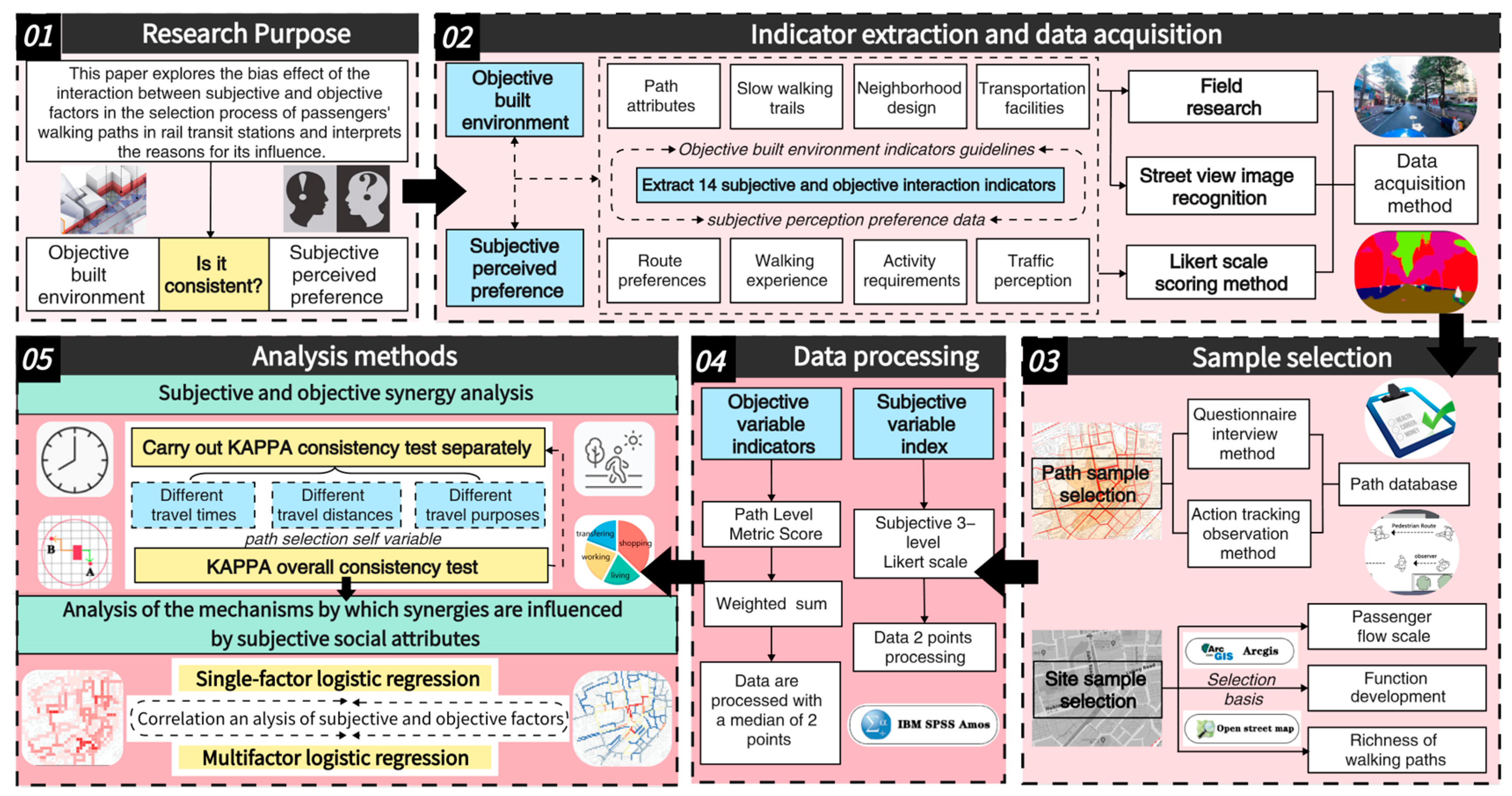
3.1. Research Framework

Taking the above analyses into account, this paper will focus on the congruence between the level of the objective environment and the subjective perception of pedestrians in the process of wayfinding. The main research framework is shown in Figure 5. It includes the following steps:
(1)
It analyzes the synergistic mechanism between subjective perception and objective environment, and the results produced, as the basis for determining the dependent variable in the later section;
(2)
Based on the references and combined with the field research, it determines the objective built environment indicator system applicable to describing the basic characteristics of walking paths in the station area;
(3)
Based on the objective environment indicators, combined with the established scholars’ research, it determines the content and reasonable acquisition method of subjective environmental perception indicators;
(4)
Based on the characteristics of the data required by the Kappa consistency test method, it processes the subjective and objective data to form the commonality indicators and conduct quantitative analyses;
(5)
It introduces multivariate logistic regression to analyze the influence relationship between the socio-economic attributes of the individual and the types of subjective and objective synergistic effects. The overall process is shown in Figure 5.

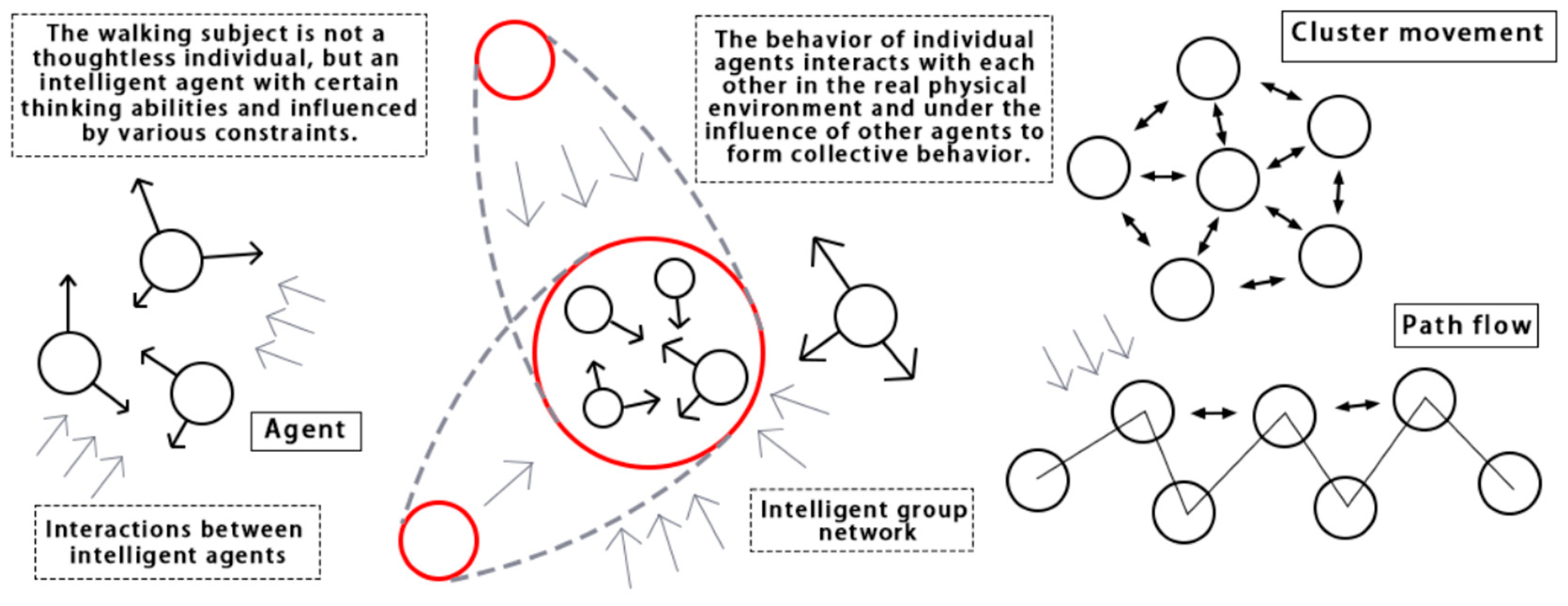
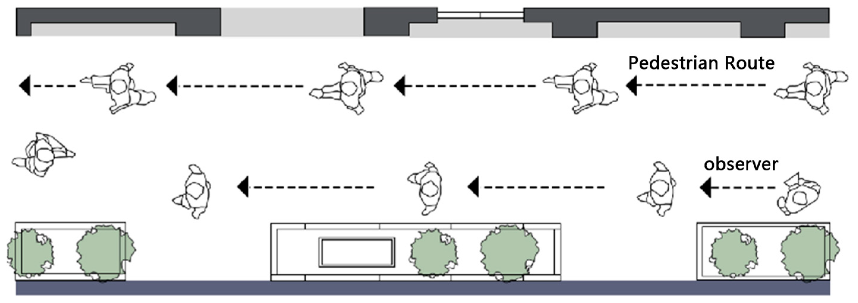
3.1.1. Relevance of Subjective Perception to the Objective Environment

The subjective impressions individuals form about their environment rely on information conveyed by the environment itself. However, the relationship between subjective perception and the environment is not always equivalent. By arranging perception and environmental factors into different combinations, four types can be identified: “strong perception-weak function”, “weak perception-strong function”, “strong perception-strong function”, and “weak perception-weak function”. The first two are collectively termed “perception deviation” while the latter two are termed “perception synergy” (Figure 6a).
① Perception Deviation: When subjective cognition exceeds the actual representation of the objective environment, this is known as “positive deviation”. In this case, the objective elements’ impact on pedestrians is more comprehensive. Although individual elements might seem ordinary, their coordinated spatial relationship and proportion can create a “1 + 1 > 2” positive overflow effect on subjective environmental perception. When pedestrians’ perception and information reception of the objective environment are lower than the actual situation, this is termed “negative deviation”. Here, the subjective impression is poorer than the actual representation, leading to a “1 + 1 < 2” imbalance. Unlike positive deviation, the high-level objective elements suppress each other when combined.
② Perception Synergy: In perception synergy, people interact with their environment while engaging in urban activities, acquiring environmental information through observation and experience and mapping it to characteristics such as quantity, size, scale, and color. For instance, upon entering a street, one might first notice the shapes and colors of trees, followed by information on their number, height, and species. This information is processed and translated in the brain, converting objective information into impressionistic words, which are then combined with cognitive attitudes or preferences to make further decisions (Figure 6b). This paper proposes an interaction framework between subjective and objective factors, analyzing the mechanisms behind these four scenarios after unifying the subjective and objective data.

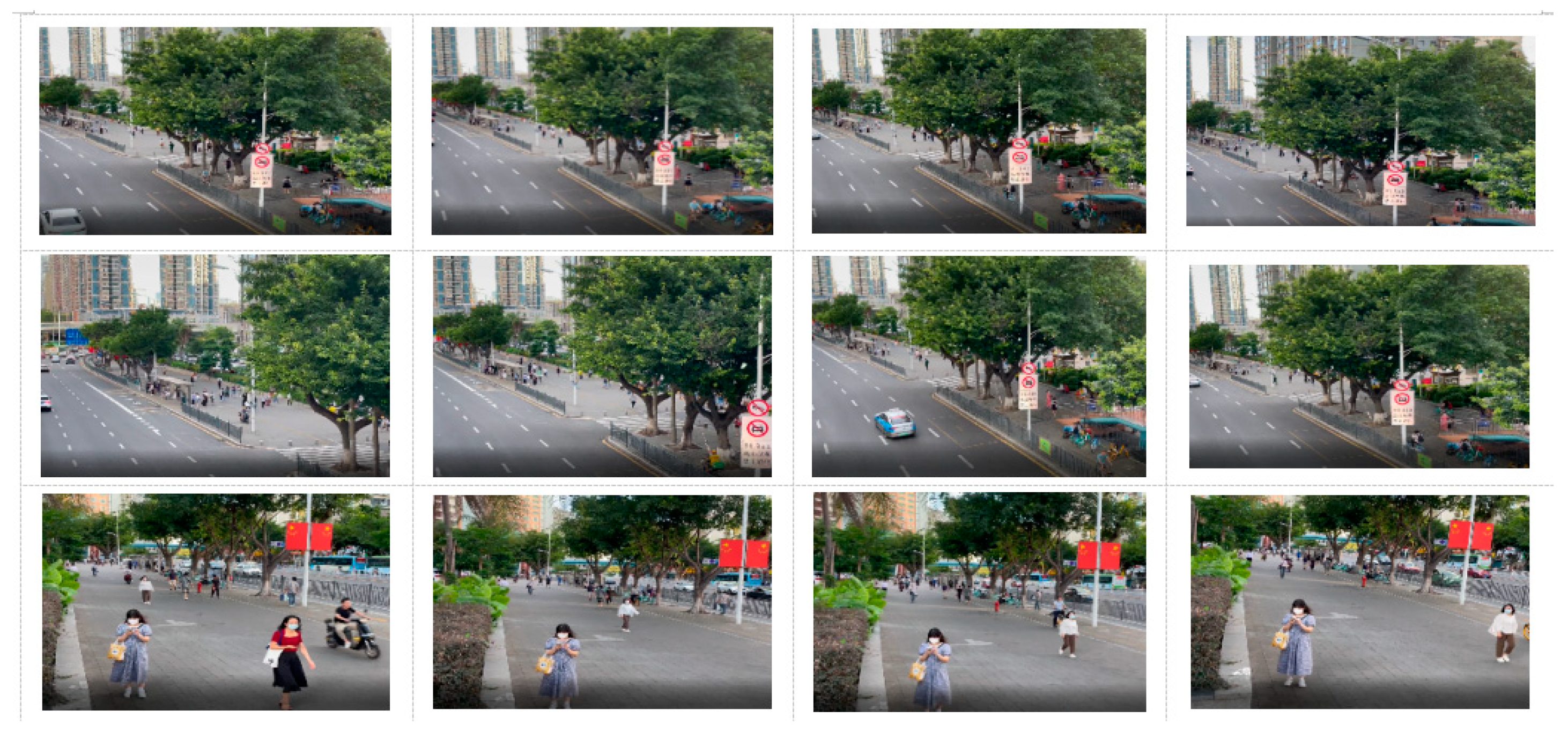
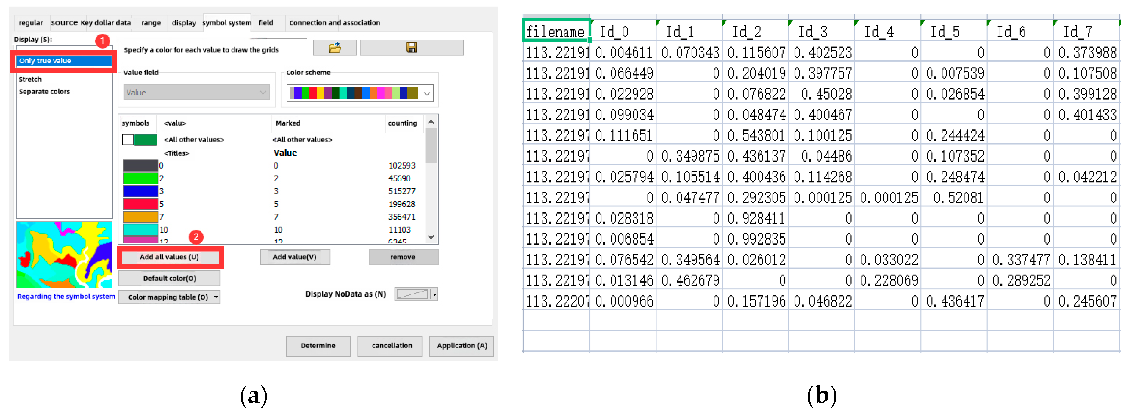
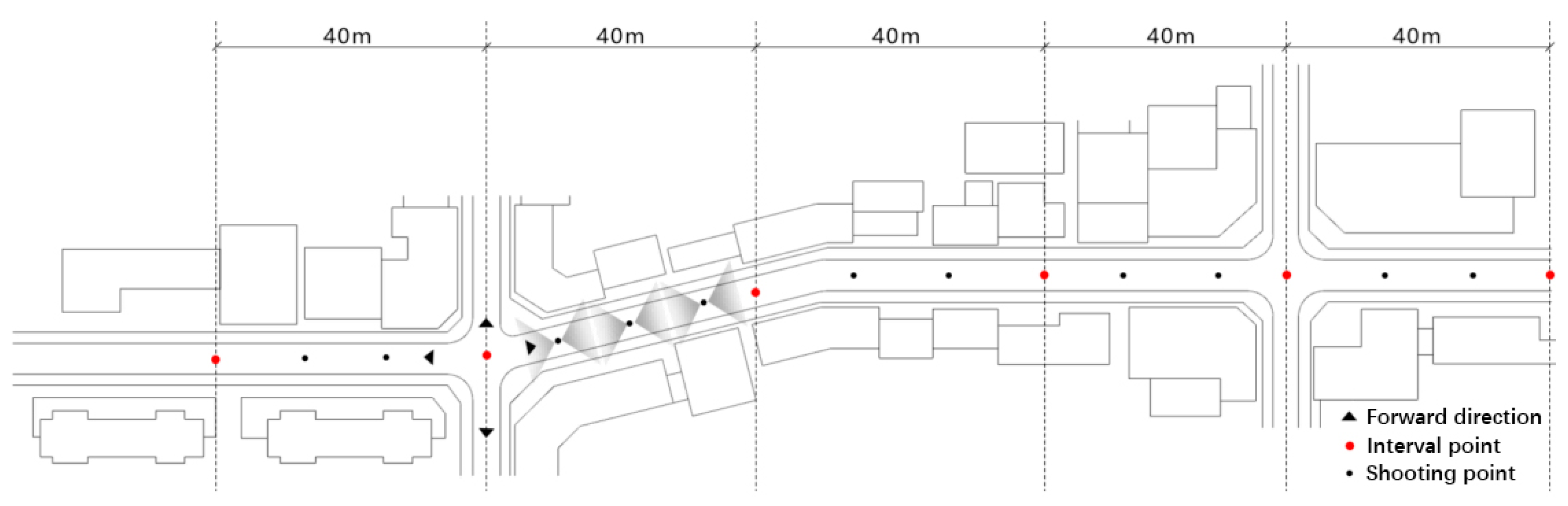
3.1.2. Access to Objective Environmental Elements

First, to facilitate the extraction of built environment parameters that can comprehensively describe the characteristics of walking paths, we decompose the elements of “walking paths” into two parts:
(1)
Inherent Attributes of the Path: These include detour degree, length, direction, etc.
(2)
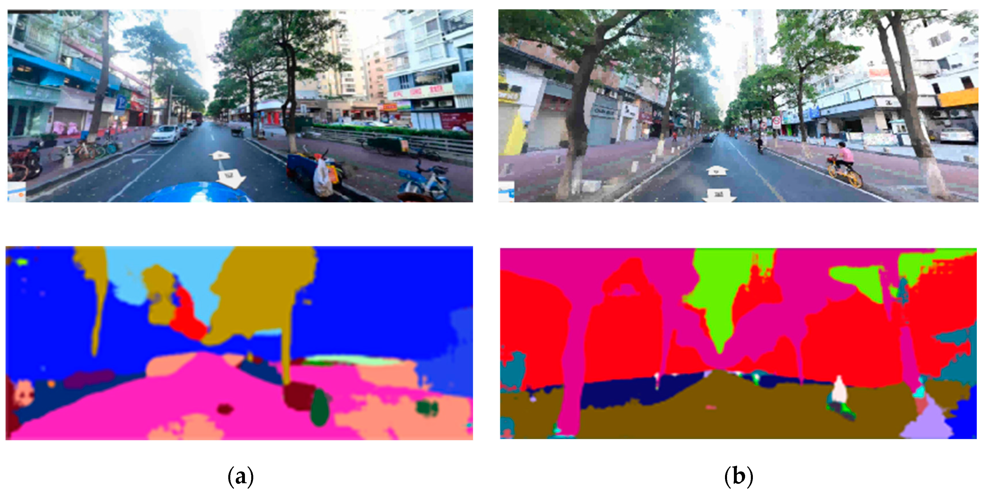
Built Environment Along the Path: Scholars have described the built environment from land use, transportation facilities, and urban design perspectives. This paper adopts a similar method, applying these three elements to the street level. Numerous scholars have summarized environmental factor indicators in built environment and transportation behavior research [44,45], but these are not directly applicable to path studies. Figure 7 below illustrates the decomposition of walking path elements into walking space, street block function, and transportation facilities [46,47].
Based on research reviews by Basu N and Zhan G, et al. [21,48], this paper uses the aggregative indicator method to construct a parameter library for the built environments of walking paths. According to the decomposition of walking path systems, the following can be stated:
  • Walking space: This includes walking experience, walking barriers, and walking aids.
  • Neighborhood Environment Along the Path: These mainly include street form characteristics (height–width ratio, building density, etc.), facility types, and landscape levels. Factors like street activity facility diversity, the proximity of street shops to walkways, and window visibility have been proven to affect walking activities, though their specific effects vary.
  • Traffic Environment: This is primarily considered from the aspects of walking safety and convenience.

Walking Space

This paper measures the levels of neighborhood walkways at three levels: the walking experience level, the walking impediment level, and the walking assistance level. Among them, the walking experience layer is directly related to physical actions. Among them, the passage width refers to the length of the walking path covered by complete paving; the pavement quality mainly examines the ground paving of the walking space, including whether the pavement is flat, whether it is broken, and whether the paving is complete; the path continuity refers to the possible interference with the walking of street segments, side openings, neighborhood entrances and exits, hutongs, and so on that pedestrians experience in the process of travelling; and the walking impediment layer mainly evaluates motor vehicles occupying the roadway. The pedestrian obstruction layer assesses the levels of motor vehicle occupancy, rubbish bins and debris stacking, etc. that obstruct walking and reduce the effective width of access and the support layer assesses the level of open space facilities along the route that promote walking activities or provide a short break to prepare for the next part of the walking journey. In addition to the above objective environmental characteristic variables describing the static walking space, it is also necessary to record the overall pedestrian activity of the walkway at the same time in terms of pedestrian density during the accompanying tracking process.
Neighborhood environment: Neighborhood elements on both sides of the route mainly include street morphology characteristics (height to width ratio, building density, etc.), facility types, and landscape levels. Factors such as the diversity of street business facilities, the distance between street shops and the pedestrian walkway, and the visible greens of windows have all been argued to have an impact on walking activities, but the specific effects vary. Among them, a diversity of features is usually positively correlated with the occurrence of walking activity, which has also been a prerequisite for a large number of studies at the macro scale, and Ozbil et al. found that the setback distance of a building from the pavement is negatively correlated with the probability of route choice [49], which is because pedestrians may feel they are under “surveillance” when the distance between the building and the pavement is too close. The reason is that when the distance between the building and the sidewalk is too close, pedestrians may feel that they are under the environment of “being watched”, which may lead to psychological avoidance. Combining the “broken window theory” and the theory of daily activities proposed by Jiang bin et al. and referring to the relevant cited studies [50], in addition to the commonly used indicator of the distance in front of the buildings along the street, we also choose the backward distance of the crowd. In addition to the common indicator of the distance between the front areas of buildings along the street, the degree of surveillance of the crowd was also selected to express the psychological safety feeling of the walkers [51].
Traffic environment: This includes walking safety and walking convenience. The number and location of footbridges, the number of intersections, the volume of motor vehicle traffic and static traffic on the street, the width of motor vehicle traffic, and the width and number of traffic lights and zebra crossings are some of the indicators commonly used to assess the perceived safety of traffic during walking [52]. The influence of specific indicators is equally controversial. In Guo et al.’s study, it was found that 46–60% of respondents considered the safety of the traffic environment to be the most important consideration in choosing a route [21]; however, at the same time, Tribby et al. evaluated the safety of the traffic environment using several objective indicators and found that the higher the safety was, the lower the likelihood was that the route would be chosen [53], regarding the influence of crossing facilities. One scholar synthesized a number of urban case studies of pedestrian subjects, all of which found that the presence of crossing facilities had a positive impact on mitigating the traffic threat of high-volume, high-mobility urban arterials, while another study found that the presence of road intersection density had a positive correlation on the selection of routes across intersections, i.e., the higher the density was, the higher the probability was of it being an alternative route node, and with the presence of intersections with traffic lights or other auxiliary intersections with traffic control facilities, the probability of becoming a selected route was further increased [54], and this finding has been confirmed at both the subjective and objective levels. Guo et al., in their study on Hong Kong City, found that traffic volume was negatively correlated with route choice and that pedestrians preferred to choose streets with relatively fewer people [21], but in another study, it was again demonstrated that the correlation between traffic volume and route choice was of low significance.
In addition to the built environment along the street, this paper selects descriptive indicators of walking path attributes to characterize walking paths. For instance, the detour rate, calculated as the ratio of the actual walking path to the shortest path, has a straightforward calculation method. Directionality lacks a unified definition and calculation method, generally expressed by the number or sum of direction changes during walking. Some scholars use the number of turns or the depth value of angle segments from spatial analysis software to describe changes in direction during walking. Given the multiple and variable exit positions, this paper establishes a vector database after collecting route data and calculates the total turning angle from the departure point using ArcGIS 10.6 to describe directional changes during wayfinding (Figure 8). The selection and calculation methods for objective built environment indicators of walking paths are shown in Table 2.

3.1.3. Subjective Perceptual Indicators of Walking Wayfinding

This paper adopts the Neighborhood Environment Walkability Scale (NEWS) proposed by Sallis [55,56]. From dimensions such as the convenience of living facilities, road conditions, and traffic conditions in the walking environment, we extract objective indicators. On this basis, we derived subjective perception indicators corresponding to objective metrics using the Likert scale method. Survey respondents were asked about the perceived importance of these objective environmental elements. To simplify the scale and ensure respondents’ patience and cooperation while maintaining scientific data collection, a three-point Likert scale was employed (0—Not Important; 1—Indifferent; 2—Very Important) [21]. For example, the overall quality of sidewalks was measured through the weighted summation of indicators such as surface damage, smoothness, and gradient. The questions were set with reference to the studies by Werner and Tribby [21,53,57] and modified according to the research site. The subjective environmental perception factors involved in this study are shown in Table 3.

3.1.4. Subjective and Objective Factor Interaction Metrics

Interaction metrics are indicators that reflect both subjective and objective dimensions. For consistency comparison, the weighted sum of objective indicators was matched with corresponding subjective question descriptions. The further conversion and calculation of indicator scores are necessary to standardize the metrics for consistency analysis. The calculation process is as follows [58]:
  • Based on the subjective questions, we calculate the weights of objective indicators for weighted summation. Since there are many objective indicators, the weight factors are determined using principal component analysis. The total score of the comprehensive objective indicators is calculated and the median is taken as the threshold to convert continuous variable values into binary variables. Scores below the median are coded as 0, and those above are coded as 1, indicating the high and low levels of the factor in question [59,60,61].
  • The results of the three-level Likert scale are dichotomized (combining 0 and 1 indicates that the factor is not important for decision making), forming positive or negative cognitive attitudes that correspond to the high and low levels of objective scores. This creates the four types of subjective–objective interaction proposed earlier.
  • After completing the data processing, we perform consistency tests and subsequent analysis.
From the above steps, 14 interaction metrics were identified, representing the factors pedestrians consider during walking and the corresponding objective environmental sources for these subjective perceptions (Table 4).

3.1.5. Process of Subject–Objective Perceptual Consistency Analysis

This paper simultaneously considers the impacts of the objective built environment, subjective cognitive preferences, and socio-economic attributes of pedestrians on wayfinding decisions. The specific analysis process is as follows:
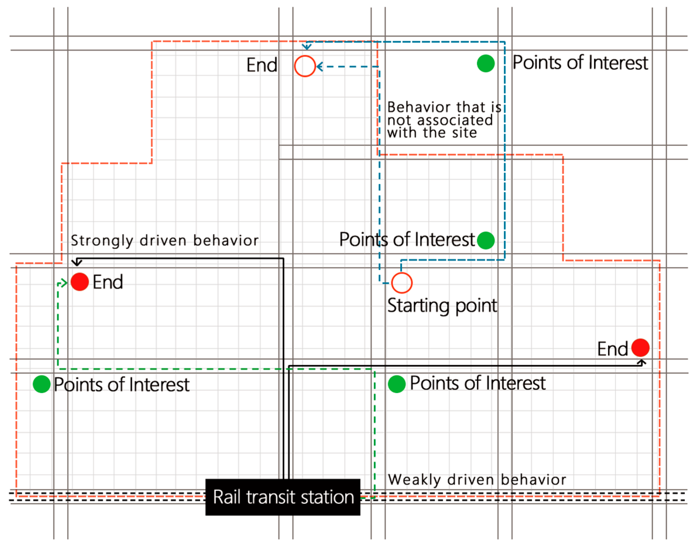
  • Selection and Establishment of Subjective and Objective Influence Parameters: Based on the characteristics and components of walking paths, we extract the objective built environment description indicators. We convert these into subjective cognitive parameters and further refine interactive indicators for consistency comparison analysis, clarifying their corresponding relationships.
  • Comprehensive Scoring of Common Objective Built Environment Influence Parameters: Using a weighted summation method, we derive comprehensive scores for objective built environment parameters and combine them with subjective scoring data. We standardize the data for mutual comparison.
  • Consistency Analysis from Two Perspectives: We classify the data from both perspectives and perform consistency analysis on the entire path sample and path samples under different travel scenarios. We visualize the path data to describe the interaction of subjective and objective factors from both mathematical and spatial perspectives and analyze the causes of deviation.

3.2. Kappa Consistency Test

The Kappa consistency test is widely used in medical diagnosis to compare the judgments of different doctors on the same condition against actual outcomes. The Kappa coefficient ranges from −1 to 1, where −1 indicates absolute disagreement, 1 indicates complete agreement, and positive values indicate varying levels of agreement: 0.0–0.20 (slight), 0.21–0.40 (fair), 0.41–0.60 (moderate), 0.61–0.80 (substantial), and 0.81–1 (almost perfect). This paper uses this method to analyze the degree of deviation between pedestrians’ judgments of the objective built environment and their subjective perceptions during wayfinding decision making.

3.3. Multinomial Logit Regression

Multinomial Logit Regression (MLR) is primarily utilized for analyzing causal relationships when the independent variables are discrete (categorical/ordinal), such as for gender, group, type, or grade, and when there are multiple dependent variables. This method is commonly applied in the fields of medicine and sociology, particularly when the research involves complex factors. MLR enables the exploration of relationships between variables and facilitates predictive analysis. In this paper, we employ MLR to investigate the influence of individual factors on variations in consistency. This method can be better applied to discrete variables, such as the choice of path program, compared with multiple linear regression. And it can reflect the non-linear change law.

4. Study Area and Data Source

In terms of the choice of study area, two main reasons were considered. (1) The difficulty of obtaining behavioral data: Generally speaking, behavioral data have strong dynamic attributes and are relatively private, and the difficulty of obtaining them restricts most in-depth studies. In Xiamen, the research group has carried out a large number of urban design practices and station-area behavioral studies, has a large quantity of first-hand data, and has the authority to set up experimental equipment around the core stations of the main lines. (2) The typicality of the urban area: Xiamen, a coastal city in Fujian Province, Southeastern China, is an early adopter of a “BRT + Metro” public transportation framework because of its geographical and topographical constraints. The city’s street network, functional zoning, residents’ travel habits, and transportation preferences exhibit distinct characteristics. These would satisfy the need for rich pathway sample collection for this study. Additionally, Line 1, being the first metro line constructed and operational in Xiamen, has a well-developed surrounding area, particularly in the city center.
Based on our extensive research on Xiamen’s rail transit, we selected Lvcuo Station as the study site, considering factors such as passenger flow types, functional layout, and the construction of the station’s pedestrian network. As a city-level transfer hub of Xiamen Metro Line 1, it is among the first to implement comprehensive TOD (Transit-Oriented Development) projects. Geographically, it is located at the intersection of Line 1 and Line 2, and belongs to the center of the old city, being surrounded by a large number of residential areas and commercial office buildings, with a high degree of urban activity and a rich composition of the population, which can basically cover all types of activities when collecting paths. From a comprehensive point of view, it was a station with a high degree of adaptability to the theme of this study, and has a certain reference value for the future development of Xiamen’s rail transit station—city integration. The delineation of the study area would take into account the negative impacts of the city’s main roads on walking activities, as well as the reasonable walking distance limits within the walking time. Finally, the scope of walking impacts had to be clarified before carrying out the study of walking activities. Combined with the actual situation, first of all, we needed to consider to avoid the interference effect of the neighboring stations. Secondly, with the normal walking to the destination tolerated for a maximum of 15 min to consider, combined with the isochronous circle simulation, combined with the relevant research and Lvcuo station of the street network of the actual situation of the study scope was determined as follows: Xianyue Road to the north, Lianyue Road to the west, Success Avenue to the east, and Lianhua South Road to the south, as shown in Figure 9a. This range basically met the walking threshold limit.
Lvcuo Station, a city-level transfer hub of Xiamen Metro Line 1, was among the first to implement comprehensive TOD (Transit-Oriented Development) projects. It is positioned as a comprehensive service station with a mature urban land development around it, leaving almost no vacant land. The study area contained approximately 1724 buildings, primarily used for business and residential purposes. Residential buildings accounted for 58.33%, commercial buildings for 16.14%, office buildings for 11.51%, and educational buildings for 8.87% (including several community kindergartens, three middle schools, and four primary schools). The east–west Yuandang Lake branch canal forms three urban parks within the area. Moreover, public service facilities within the study area generally met the local needs, and the overall functional distribution of the district was relatively balanced. The layout aligned with the concentric circle characteristics of the TOD model, where commercial and office facilities are primarily arranged along the central cross-arterial roads, transitioning outward into mixed-use, residential areas and urban landscapes, as depicted in Figure 9b. This made the area highly valuable for research in terms of passenger flow scale, the diversity of walking path samples, and district functional development, thus ensuring the reliability of data analysis conclusions to some extent.
The research team organized fixed-point observations at various walking observation points connected directly to different metro exits at Lvcuo Station. Through movement observation, path tracking, and questionnaire interviews, comprehensive wayfinding data were collected; the path tracking method and data collection process are shown in Figure 10 and Figure 11. To account for variations in pedestrian flow during different peak periods, random sampling was conducted during the morning (7:30–9:00), midday (11:00–12:30), and evening peaks (18:00–19:00), yielding 150, 90, and 170 walking paths, respectively. In the first round, complete path data for 432 paths and corresponding questionnaire results were obtained. After excluding paths that were too short and did not involve any choice behavior (e.g., pedestrians reaching their destination within 300 m of exiting the station), 31 data points were removed. Additional surveys were conducted to obtain a complete set of 410 valid data points. Tracking personnel mapped the trajectories, recording starting points and other relevant data, and established a walking path database using the ArcGIS platform.
In obtaining data on the built environments of streets, most studies utilize Built Environment Audit tools such as checklists. Compared to acquiring information through Geographic Information Systems (GISs) or aerial photographs for translation and identification (Figure 12), this method allows for the direct observation and evaluation of physical characteristics in urban spaces, such as street trees and sidewalk widths, and the subsequent quantification of these features [62]. This study adopted the environmental audit approach while balancing the workload of data collection by integrating the visual image semantic segmentation technology of Fully Convolutional Networks (FCNs) with field measurements (Figure 13). Neural-network-based image semantic segmentation technology has matured and is widely used in research on pedestrian activity impacts and built environment assessments in street spaces [63]. During sampling, attention must be paid to sampling intervals; Jan Gehl, in “Life Between Buildings”, suggests that 30–35 m is the maximum distance that constitutes place space.
Accordingly, this study selected a 40 m sampling interval based on related street-view image sampling research, balancing efficiency and accuracy in environmental description (Figure 14). The built environment level at the path level was calculated using a weighted sum of street segment layers. Street-view images were collected in units of street segments, with high-resolution photos taken at multiple points along the same segment. These images were adjusted for exposure and contrast before being processed by image processing software for feature recognition and segmentation. The image processing software, developed by scholar Guan Qingfeng and others, is a Caffe-based fully convolutional neural network image semantic segmentation tool built on the ADE dataset [64].

5. Results

5.1. Overall Analysis of Pedestrian Wayfinding Decisions at the Station Area

Figure 15 shows the statistical summary of all path samples collected for this study. Using the ArcGIS system, a 30 m × 30 m grid was set to segment the paths and count the number of path coverages within each cell. Samples were analyzed based on travel purpose and individual attributes. Figure 15 visualizes the statistical frequency of six types of paths.
Figure 16 and Figure 17 show a cross-analysis of respondents’ age and path data. The 15–25 and 26–45 age groups were the most active within the site, primarily engaging in “family affairs” and “work/school” activities, with the widest path coverage. The highest overlap of walking paths was observed in the 15–25 age group, with areas such as Jiangtou West Road, Lvcuo Road, and Exit 12 of Xinhe Central Plaza being the hotspots. The 45+ age group had relatively smaller and evenly distributed activity ranges, primarily for family affairs and fitness, extending into surrounding communities. Figure 14 illustrates the travel purpose proportions and spatial distribution of paths for male and female pedestrians. Women showed higher activity in leisure shopping compared to men but a lower presence in fitness activities. In the early morning peak period, more women walked for family affairs. Men’s walking activities were more concentrated in the core area while women’s activities, though more dispersed overall, were particularly active in commercial complexes like HuayongTiandi Commercial Plaza, Panji-Lianyue Lane, and Xinhuadu Shopping Plaza.
Table 5 below summarizes the performance of common subjective and objective factors for the entire sample. It reveals a significant deviation in the interaction of subjective and objective factors influencing pedestrians. The environmental factors causing these deviations generally align with the walking behavior characteristics and needs of departing passengers. Factors such as path distance, the fulfillment of along-the-way consumption needs, vibrant urban activities, street crossability, and path connectivity show synergy at the subjective and objective levels, reflecting the immediate needs for “efficiency”, “convenience”, and “on-the-go services” of pedestrians in the station area.
Among the 14 interaction metrics, 10 show positive deviations, indicating a higher probability of positive deviation in environmental factor information transmission. For example, 70.00% of pedestrians believed their chosen route was the shortest to their destination, which aligned with the actual situation, whereas 15.12% misjudged. Additionally, 36.59% of pedestrians considered sidewalk quality important for their route choice, and this aligned with actual conditions. However, 24.88% recognized the quality of their chosen route’s sidewalk even if it was poor, possibly due to other non-sidewalk space factors enhancing their tolerance for sidewalk quality. Conversely, 38.54% who chose high-quality sidewalks indicated that this factor was not crucial for their route choice.
Figure 18 illustrates a spatial correlation in the interaction of subjective and objective factors of walking paths.
Houbin North Road, Luling Road, and the southern segment of Jiahe Road tended to produce negative deviations for pedestrians. These major streets, lined with high-rise office buildings, exhibited high sidewalk quality but did not align well with subjective perceptions, leading to negative deviations. In contrast, the northern segment of Jiahe Road showed positive deviations, likely due to balanced street-level elements. Houbin North Road and the southern Jiahe Road hosted a concentration of community service-oriented businesses under high-rise buildings, which may not have matched the high dynamic pedestrian flow and foster walkable secondary activities. This resulted in the large-scale walking space being underutilized. Conversely, the northern segment of Jiahe Road and surrounding areas like Oriental Paris Plaza, Jiangtou West Road, and Lvcuo Road featured more active commercial activities and smaller and flexible shops with public-oriented attributes, creating an engaging street interface that positively impacted pedestrian perception. From a street space design perspective, maintaining subjective–objective synergy is the basic goal, with positive deviations being optimal and negative deviations the least desirable. Negative deviations indicate that the objective built environment resources, though quantitatively adequate, are improperly configured or lack “stimulating elements”, leading to misperception and resource waste.
Additionally, the figure shows a positive correlation between the occurrence of positive deviations and street landscape greening levels. Southern residential communities have lower walking space and street facility standards; yet, pedestrians show higher acceptance and control over the environment, suggesting that landscape improvements may enhance visual comfort and positively influence subjective perceptions. Compared to the northern blocks, the southern blocks’ street network forms have significantly changed, influencing path distribution preferences. Dense street networks can reduce perceived space scales and create a lively walking atmosphere, stabilizing pedestrian walking psychology, while enhancing landscape greening under similar street networks improves visual comfort and subjective environmental perception.

5.2. Consistency Analysis under Different Travel Scenarios

A complete travel chain can be broken down by travel time, distance, and purpose (Table 6). Further consistency analysis is conducted on path data marked by these three classification methods (Figure 19).

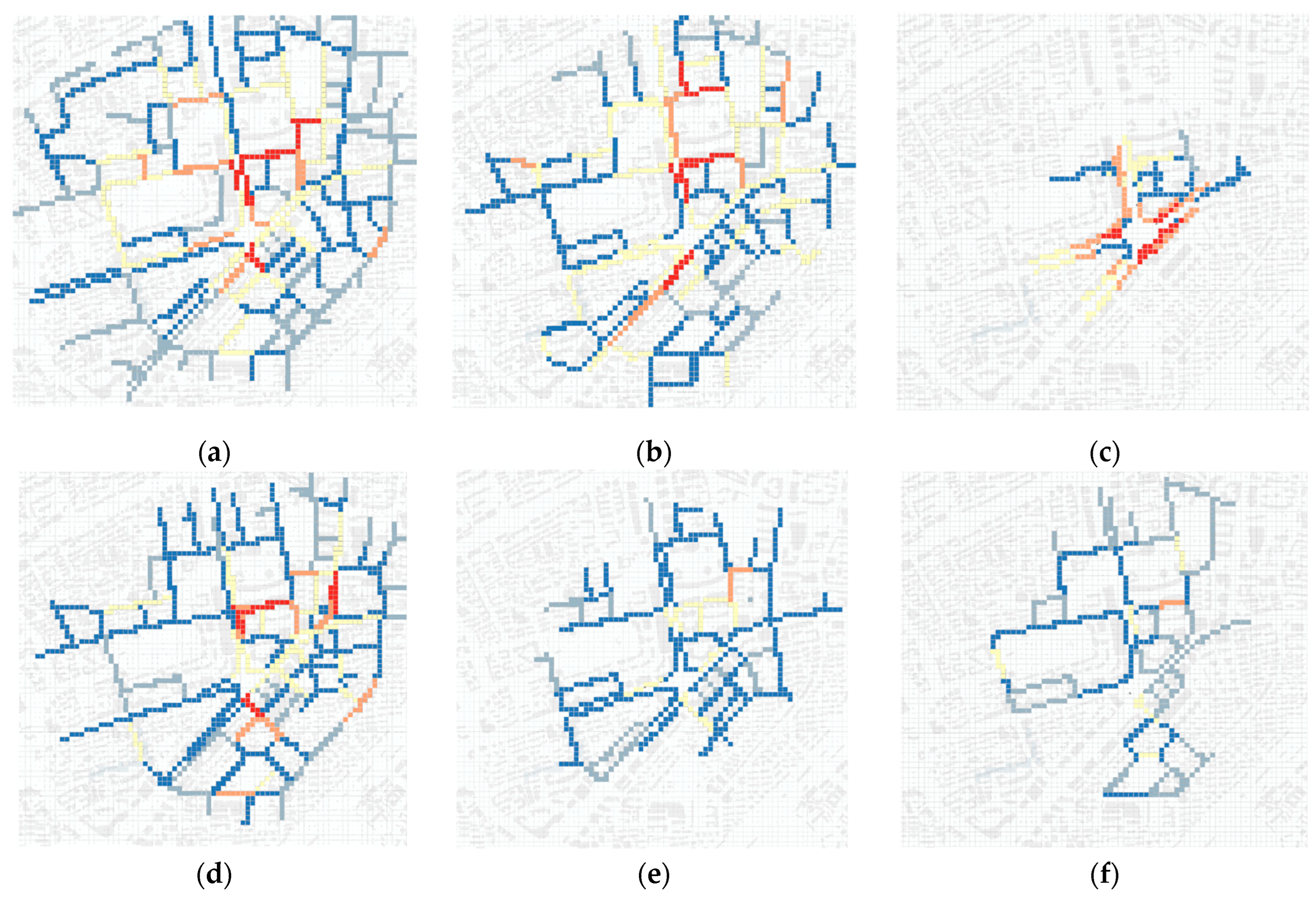
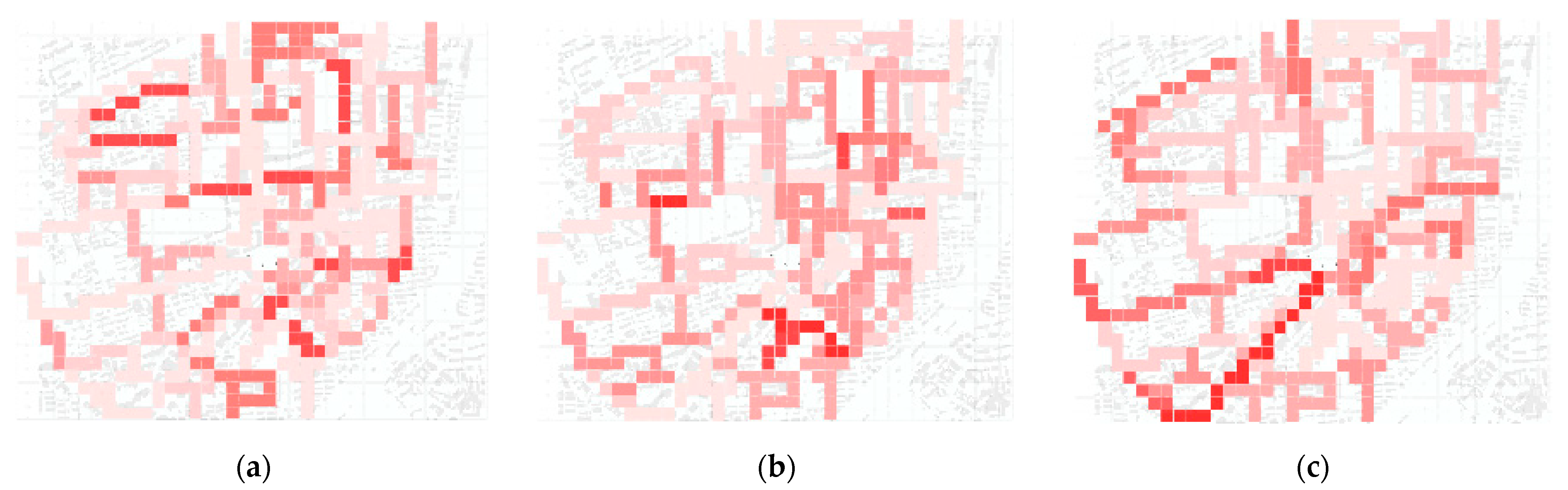
5.2.1. Consistency Analysis of Subjective and Objective Factors at Different Times of Day

Table 7 presents the results of the consistency analysis of subjective and objective factors across different peak times. The consistency of travel perceptions varied significantly between groups.
Firstly, the pursuit of walking path attributes remains a primary determinant of route selection. The results show that pedestrian perception of walking distance maintains high consistency across different travel periods whereas the direction of travel only exhibits consistency during the evening peak, with inconsistencies in the morning and midday periods. This suggests that walking distance is prioritized over walking direction. The method of measuring distance also varies: in daily life, distance is often described as “an 800-m walk” or “an 8-min walk”; although the actual walking cost is the same, the concept of time is more easily understood by pedestrians. This is particularly relevant for those with strong travel motivations, for whom time is the primary factor in route cost. Consistency in perception is still influenced by travel demand, with midday peak showing direction consistency possibly due to the hot climate reinforcing environmental recognition to reach destinations quickly.
Secondly, the consistency of walking space factors is generally poor, with a predominance of “negative deviations”. The quality of walking space, including factors such as sidewalk condition, is not easily perceived, especially by pedestrians with strong travel objectives, who may overlook the tactile experience of walking even if the sidewalk is damaged (within acceptable limits). However, this does not imply that these factors are unimportant. Although comfort may have a low priority in perception, it can have a potential motivating effect, influencing the perception of other environmental factors and forming a “positive deviation” in walking attitudes.
Lastly, the consistency of neighborhood environment factors varies across the three periods. The evening peak showed higher consistency for most variables, indicating that the objective value of the neighborhood environment was maximized during this time. The “satisfaction of consumption needs” factor had the highest coefficient whereas its impact was lower in the morning and midday periods. This was related to the behavioral needs determined by the type of walking activity. In the morning and midday, travel is primarily driven by strong objectives, with a focus on “efficiency” and “convenience”, leading to a reduced perception of neighborhood environment or facility distribution. The “crossability of streets” and “connectivity of paths” showed good subjective–objective consistency across all periods. Pedestrians frequently cross urban roads to experience different street-side spaces and gain more walking opportunities, often preferring streets with lower vehicular traffic and soft barriers like green belts.

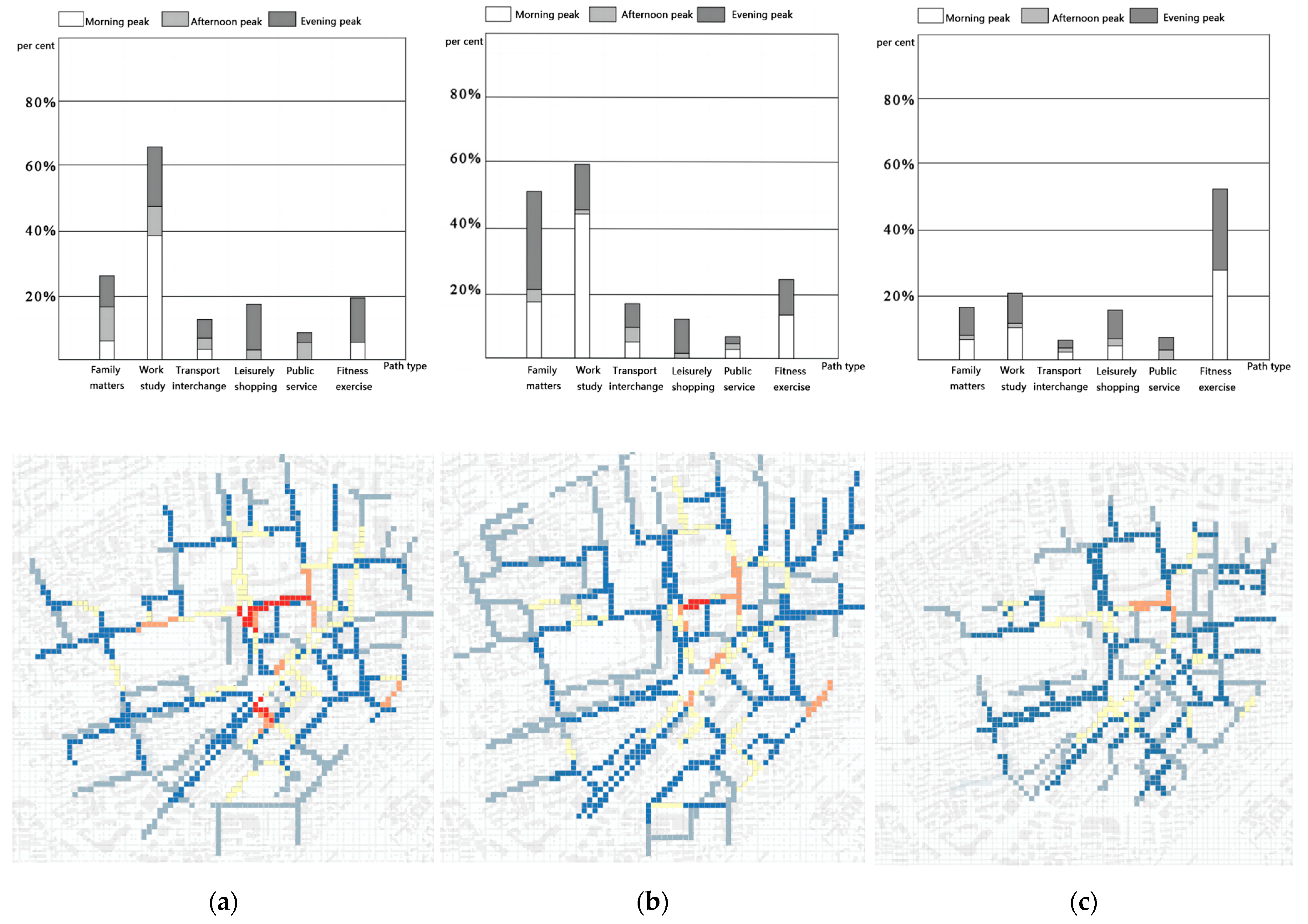
5.2.2. Consistency Analysis of Subjective and Objective Factors by Walking Distance

Based on the sample statistics and relevant research, the collected path samples were divided into three groups by length for consistency testing (Table 8). Two main considerations were as follows:
  • Pedestrians have a certain tolerance threshold for walking distance. As the distance increases, fatigue sets in, influencing subjective perception.
  • The radiation effect of rail transit stations creates a layering effect, with different environmental factors performing differently within each layer.
Table 8 shows the environmental perceptions of pedestrians within different distance layers. The perception of walking path and direction is significant within the core layer but diminishes with increased distance. Neighborhood environment factors are best perceived within the second distance layer, offering the most variety. Possible reasons include the following:
  • The 700–1100 m range covers the optimal walking distance (around 800 m), allowing pedestrians to transition from uncertainty in wayfinding to street stability.
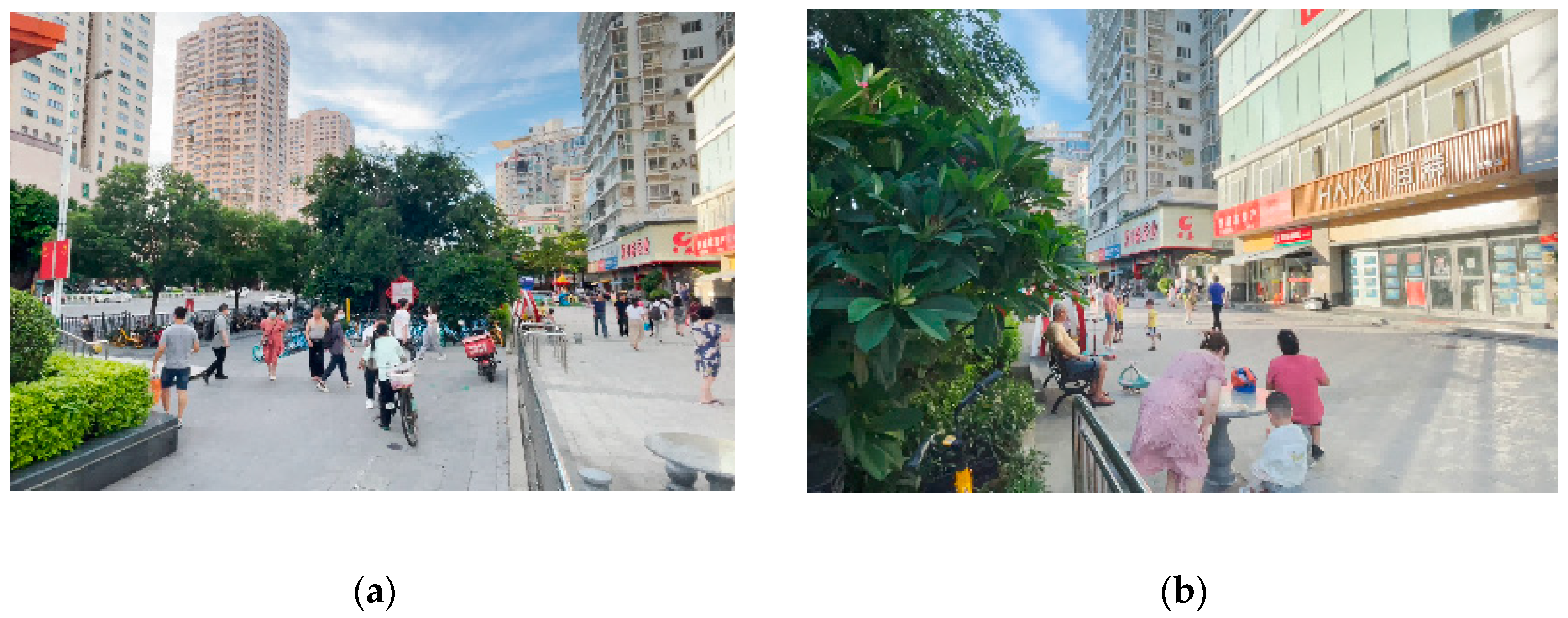
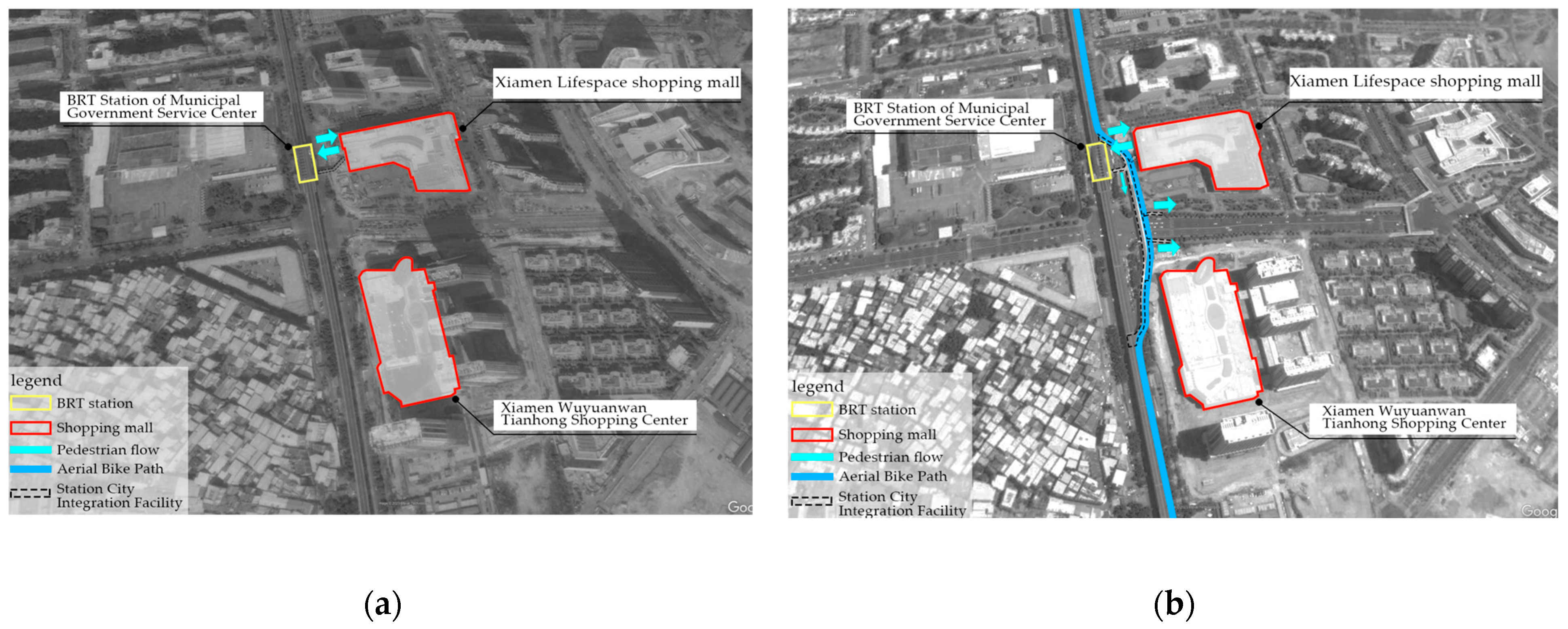
  • The middle layer’s street function and facility arrangement better match pedestrian preferences and the street design is more pedestrian-friendly. Field observations show that some neighborhood environment elements have a motivating effect. For instance, the plaza in front of Zhongmin Baihui Mall, accessed directly from Exit 8 of Lvcuo Station, attracts pedestrians during the evening peak, altering walking paths (Figure 20). In contrast, the dedicated pedestrian paths along the roadway are less utilized. Although pedestrians must navigate steps, barriers, and other pedestrians, the vibrant urban scene and public commercial properties positively impact pedestrian perceptions. In the third distance layer, most elements of path attributes, walking space quality, and neighborhood environment show “negative deviations”, highlighting the impact of walking distance on physical tolerance thresholds and subjective cognition.
Traffic environment perception maintains high consistency across different distances, aligning with Alfonzo M.A.s’ “hierarchy of walking needs”, where “utility” is the first level and “accessibility” is the second. The stability, safety, and opportunity within the traffic environment are top priorities for pedestrians in station areas. The fulfillment of functional needs and the stability of the traffic environment are foundational, triggering higher-level needs.

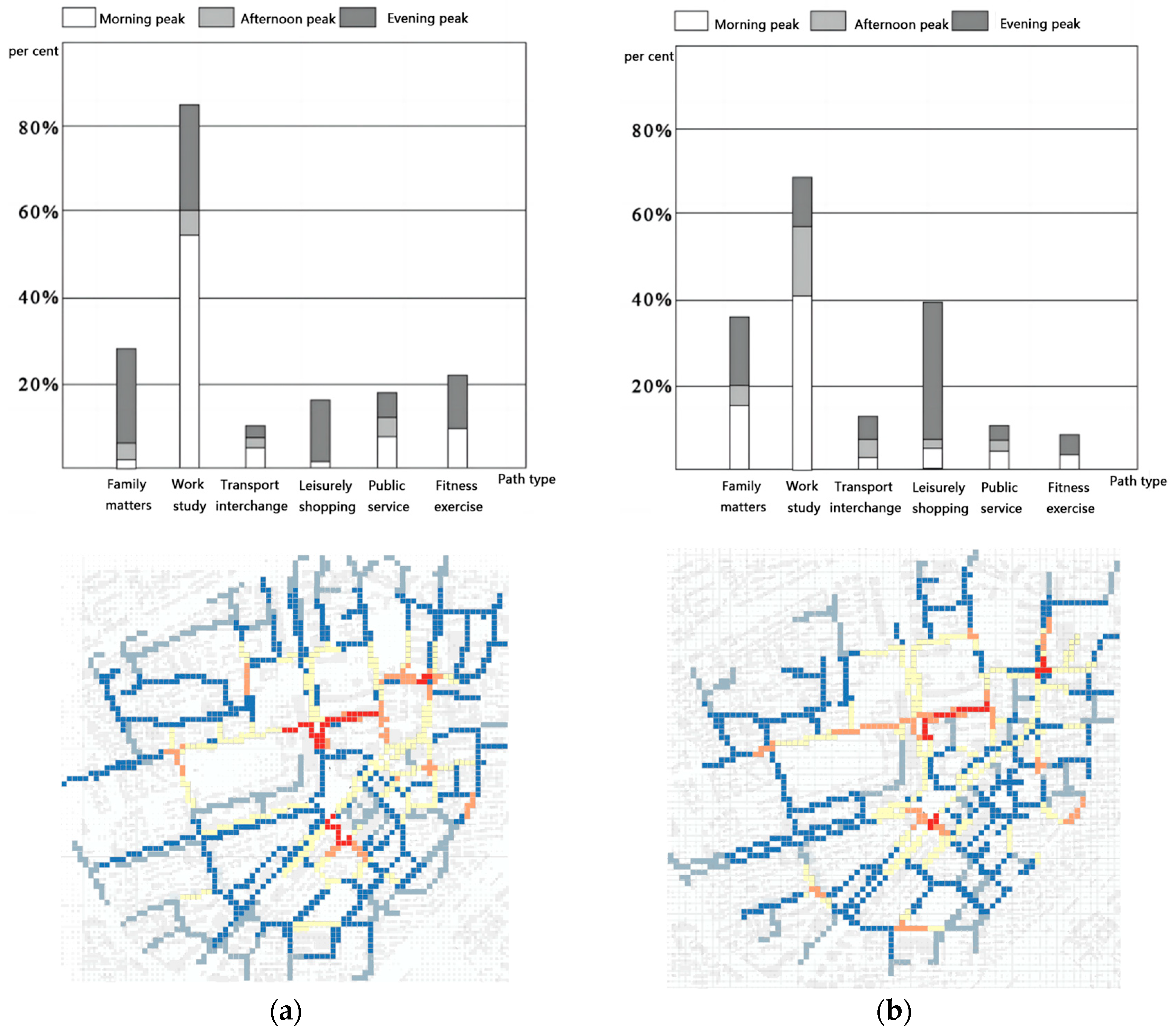
5.2.3. Consistency Analysis of Subjective and Objective Factors for Different Travel Purposes

The psychological perceptions and acceptable time costs for pedestrians vary depending on their travel purposes, affecting their cognitive perceptions during their journeys. Travel plans under strong/weak travel purposes differ in walking attention, perception ability, and visual capture ability. As shown in Table 9, pedestrians with strong travel purposes are noticeably sensitive to factors such as distance, direction, walking smoothness, the number of non-motorized vehicles, and route connectivity. In contrast, they tend to overlook street furniture, resting facilities, activities along the way, and landscape greening. For instance, about 56% of pedestrians on high-performance routes still considered that activities, consumption functions, and landscape greening along the way were not important to their route decisions. In comparison, pedestrians with weak travel purposes focus more on resting opportunities, visual comfort, and meeting consumption needs. They also pay attention to traffic facilities and the environment, similar to those with strong travel purposes.
Overall, even if the objective environmental elements meet expectations, factors such as travel purpose, time of day, or walking distance can lead to negative judgments about the environment. This indicates that the subjective perception formed by social experience, historical cognition, individual preferences, and action needs often has a greater influence than objective environmental factors. The spatial characteristics of rail transit stations and the walking conditions faced by departing passengers differ from those in other types of public spaces, showing differences in the prioritization and interpretation of environmental factors. Data analysis indicates that the probability of consistent perception for path attributes like distance, direction, and traffic environment factors is as follows: perception synergy > positive deviation > negative deviation. The perception of walking space quality factors mainly shows negative deviations. However, this does not negate the importance of walking space quality. From the order of environmental information capture during pedestrian activities, factors like sidewalk quality are potential motivating elements. When they do not hinder the walking process, they are not strongly perceived due to habitual daily travel. However, when at a high level, they may subtly enhance pedestrian experiences. Neighborhood design includes representative elements (spatial form, interfaces) and experiential elements (land use, activities). The results vary under different analysis standards, but generally, the interaction is mainly characterized by subjective–objective synergy and positive deviation.

5.3. Effect of Individual Socio-Economic Attributes on Perceived Consistency

5.3.1. Single-Factor Logistic Regression

The subjective perception data, after processing, were classified into two categories. Logistic regression models were employed with these as the dependent variables to analyze their correlation with objective built environment variables. It is important to note that path attributes did not vary with objective environmental changes, rendering the analysis results meaningless, and therefore, they were not included in the analytical model. Table 10 below presents the output of the regression coefficients:

5.3.2. Multifactor Logistic Regression

Table 11 and Table 12 are the results of specific analyses. The objective levels of visual attractiveness, occurrence of urban activities, street traversability, and route connectivity exhibit positive and significant correlations with subjective perception coefficients. This indicates that pedestrians are more likely to perceive these factors when their objective levels are higher. Conversely, “supportive walking facilities” and “opportunities to satisfy consumption needs along the way” show negative correlations, suggesting that the perception intensity is not necessarily stronger with more recreational facilities and a richer mix of street functions. Drawing from the discussion in Section 5.1, it is speculated that this may be due to the fact that the use of recreational facilities and the occurrence of commercial transactions in shops depend more on pedestrians actively deviating from preset routes and going there; hence, they are influenced by various other factors such as facility location, shop composition, and promotional methods. Factors with positive correlations indicate a higher probability of occurring in a mutually beneficial manner between subjective and objective aspects compared to other factors. Conversely, factors with negative correlations indicate a higher probability of deviation between subjective and objective interactions, but this does not imply an absolute negative relationship. Factors with non-significant coefficients may be influenced by other potential factors or data sampling errors.

5.3.3. Correlation Analysis of Subjective and Objective Factors

Further, 14 groups of multivariate logistic regression models were constructed by integrating the basic socio-economic attributes of pedestrians with the categories of subjective–objective perceptual coordination. These models were horizontally compared, using subjective–objective consistency (0) as the reference group, to fit both positive bias (1) and negative bias (2) outcomes separately. In each model, with subjective–objective consistency as the reference group, the coefficient for each variable signifies the relative probability of occurrence compared to the reference group. A positive coefficient indicates a higher likelihood of occurrence compared to the reference group while a negative coefficient suggests the opposite. The computational outcomes are presented below. Overall, different types of socio-economic attributes have significant impacts on the synergy between subjective and objective perceptions. However, the extents of their influence and their effects vary.

5.4. Mechanism Analysis of Subjective and Objective Synergy in the Process of Walking Path-Finding in Rail Transit Station Area

In examining the characteristics and constituent elements of pedestrian pathways, several observations emerge: (1) Walking distance remains the primary concern for pedestrians, with relatively less interest shown in directional perception during the journey. This lack of emphasis on directionality perception may be attributed to the probability distribution of sampled individuals, although no discernible patterns of bias were evident from the data collected in this study. (2) Environmental factors assessing the quality of pedestrian spaces predominantly lead to negative biases. Even when pedestrians choose routes with well-maintained surfaces, clear walking spaces, and strong spatial continuity, they do not tend to overly focus on these factors subjectively, and nor do they allow them to significantly influence their decision making. (3) Perceptions of street environments or pedestrian amenities are not consistent and vary across different travel contexts. Notably, during the evening rush hours, pedestrians traveling distances ranging from 700 to 1100 m, without strict time constraints or strong destination-driven motivations, exhibit the highest levels of attention towards street environments.
They are more prone to forming perceptual coordination and are more likely to form subjective acknowledgments of street environments, events, shops, facilities, and other content, even under less-than-ideal conditions. Among all factors describing street environments, the diversity of commercial facilities and the occurrence of urban activities are more likely to be noticed. (4) The perception of transportation facilities in station areas remains relatively stable across different travel scenarios. Specifically, the consistency level of pedestrian pathways’ traversability and connectivity to pedestrian paths remains consistently high. This to some extent reflects the influence of the unique spatial attributes of rail transit station areas on walking activities. Exiting crowds maintain fundamental pursuits of “efficiency” and “accessibility” throughout their activities. Elements such as the integrity of pedestrian crossing facilities (e.g., pedestrian bridges, underground passages), forms of pedestrian flow control at road intersections, and street network density ensure opportunities for exploration and the possibility of travel options during walking, albeit without exerting dominant influence.
A single-factor logistic regression model further analyzed the correlation between subjective perceptions and their corresponding objective environmental factors. Unlike correlation analysis, logistic regression models reflect the extent of changes in subjective perceptions brought about by unit changes in objective environmental factors and simultaneously provide the corresponding numerical relationships. Among the 14 interaction variables, the visual attractiveness of street facilities, the presence of street activities, street traversability, and route connectivity were positively correlated with subjective perception attitudes. This indicates that the higher the objective levels of these factors are, the better the subjective perceptions are.
Multifactor logistic regression considers the intervention of the above pathfinding decision behavior from the perspectives of characteristic attributes of pedestrian subjects.
(1)
Gender
Women tend to overestimate the actual distance of a route, a phenomenon that can be jointly explained with sociological research. When traveling without time constraints, pedestrians are prone to overestimating the actual walking distance of a route and may relax in terms of walking time. During the walking process, women are easily drawn to the occurrence of shops or activities along the way, leading to a higher likelihood of overestimating the route distance. Furthermore, compared to men, women place a much higher emphasis on the safety of walking environments and show greater concern for street formats and the occurrence of street-side activities. Improvements in these objective environmental factors promote women’s positive perceptions during walking and compensate for deficiencies in other objective environmental factors. Lastly, women have a lower perception of traffic environments compared to men. A higher level of street traversability does not necessarily increase the probability of being chosen by women. However, a stable walking environment facilitates women’s perception of the environment while men are more concerned about the degree of street traversability.
This indicates that due to differences in physiological and psychological perceptual conditions, men and women exhibit significant differences in experiencing the same urban environmental conditions at various levels, such as perceptible elements, cognitive incentive mechanisms, and cognitive thinking logic. Men tend to be more rational and may focus more on utilitarian elements (such as transportation facilities and traversability opportunities) while women are more concerned with representational and experiential elements (such as street facades, street-side activities, landscapes, and artistic constructions). As the latter are more sensitive, the presence of other potential factors (such as weather conditions) may have a greater impact on women.
(2)
Social Context
From the analysis results of this study, it was observed that the parameter estimates for education level and household income were mostly insignificant, which conflicted with previous research. This inconsistency may be attributed to potential errors in data sampling and processing. Given the scenario setting during the preliminary research phase of this study, where individuals traveled to their destinations by public transportation and walking connections, differences may exist between this population and those typically studied in sociology. Without considering these factors, the influence of social and professional backgrounds on the environmental cognitive preferences of the pedestrian groups in this study appears relatively small (or can be understood as these factors not playing a significant role in the transformation of objective data into subjective cognition processes).
However, this does not imply complete insignificance. For instance, higher-income groups may be more concerned about route connectivity during travel and are more likely to deviate from established routes to visit points of interest along the way. Additionally, higher-income groups tend to prefer streets with richer functionalities. Pedestrians from different social classes and backgrounds still exhibit differences in their memory points of urban elements and cognitive habits, which further affect their analysis of street environments and walking decisions.
(3)
Age
Age, another significant demographic factor alongside gender, plays a role in shaping cognitive environmental perceptions and pathway preferences similar to gender but with less pronounced differences, as evidenced by the coefficient estimates of the three age groups delineated in this study. In comparison to pedestrians aged 15–25, individuals aged 25–45 tend to overestimate the distance and direction of their travel routes, and this tendency increases with age. However, these differences are not as pronounced as gender disparities. Moreover, individuals in this age bracket typically do not opt for the shortest route to their destination immediately.
(4)
Motor Vehicle Dependence
The analysis reveals that individuals who frequently choose walking over driving, compared to those who possess a driver’s license and regularly opt for motorized transportation, are more prone to underestimating route distances. Additionally, they exhibit a preference for streets with fewer obstacles, clean street interfaces, and higher pedestrian traffic. Moreover, pedestrian-oriented groups tend to prefer streets with diverse commercial establishments that cater to various shopping and dining needs. Visual attractiveness and the occurrence of street activities also serve as factors influencing their route selection during travel.
(5)
Weather
The inquiry into whether weather conditions affect the choices of pedestrian groups does not pertain to the basic attributes of pedestrians but rather to their travel preferences and cognitive layers. In terms of environmental cognitive mechanisms, it falls under potential influencing factors. From the results of model fitting, it is evident that weather conditions have a significant impact on the perception coordination of multiple factors. Groups deciding whether to walk based on weather conditions tend to have a more positive perception of the objective environment and are inclined to affirm environmental conditions at the subjective level. It is evident that the basic socio-economic attributes of pedestrians and the cognitive habits caused by their past experiences may to some extent influence their understanding of the objective environment and subsequently feed back into their behavioral decisions. These social attributes may play a role as “moderators” and incentives without directly impacting walking behavior. However, they can influence how pedestrians perceive the environment or catalyze the emergence of different cognitive attitudes, further affecting the bias in the interaction between subjective and objective factors.

6. Discussions

This article proposes a behavioral research method based on the characteristics of subjective and objective information translation paths. This method analyzes the consistency performance of the route decision-making scheme for passengers in the area around a rail transit station during the commute peak period when walking to the destination, which is affected by the interaction between the objective environment presentation level and the subjective environment perception. It is obtained through Kappa consistency analysis and logistic regression model. The results obtained effectively responded to the research questions raised above:
  • Based on the traditional behavioral dynamics model, an abstract model of walking paths has been proposed, and it has been demonstrated through the observation and investigation of the entire process of passenger flow generation, and it is used to quantify the built environments of walking paths.
  • Consistency analysis and a logistic regression model verified that the objective built environment and subjective perception factors have a common influence, but in most cases, it is deviation rather than synergy.
  • Consistency analysis mainly analyzed the degree of synergy between the two. The components of this quantitative relationship need to be compared with each other to reflect different synergy effects. The coefficients analyzed by the logistic regression method have a substantial impact.
The findings revealed an intriguing conclusion that aligns with the principles of classical environmental psychology in behavioral studies: “The overall impression generated by the subjective initiative of the agent’s cognition and the combination of different objective elements is greater than the sum of their individual presentations”. This conclusion is consistent with the principles of Gestalt psychology, which posits that individuals tend to integrate parts of information into a whole during perception, resulting in a richer experience compared to the perception of individual parts alone. This is known as the “principle of Gestalt superiority” [65].
Based on the research findings, it was observed that in most cases, synergistic interactions between subjective and objective factors were relatively rare (with lower levels of Kappa coefficients) while occurrences of positive and negative biases were more prevalent. The levels of information conveyed by subjective environmental perception and objective environmental factors were not equivalent. The subjective cognitive abilities of pedestrians, influenced by various factors such as individual characteristics and travel preferences, exhibited variations in the interpretation and understanding of the objective environment. This directly influenced the occurrence of route choice behaviors. Additionally, cognitive coordination phenomena in pedestrians varied across different travel contexts.

6.1. Theoretical Innovation of the Research

This study had the following two theoretical innovations in terms of theoretical research:
For the research object, this article disassembles it into two levels: the meso-level research scope, “rail transit walking influence domain”, and individual action level “walking path”. First of all, the study of the influence domain of rail transit stations is the focus of current theoretical research in related fields. It is also an important spatial element to promote the connection between stations and cities and measure the level of station–city integration. This was the first time that the radiation impact of rail transit stations was materialized to include functions. Urban elements such as business formats, pedestrian activities, and landscape systems were included. Among them, the existence of walking activities is the main mode of transportation that helps outbound passengers transform into urban active people. This article has focused on the entire process of passenger flow in rail transit stations from “emergence” to the formation of stable “paths” under high-pressure conditions. It can not only improve the understanding of the composite attributes of station-area urban space but also help deepen the understanding of the whole process of walking activities. Secondly, different from existing related research on walking paths that use street segments as the basic unit, this paper has disassembled the entire process of walking behavior in rail transit stations, extracted the path selection environment, and retained walking behavior based on the continuous perspective of fluid mechanics. Basic concepts of paths, such as path length, turning direction and other attributes. It has further paid attention to the occurrence of choices and decision-making behaviors from the perspectives of discrete individuals and paid attention to their impact. Therefore, it can more truly reflect pedestrians’ consideration of the entire travel process and the complete shape of a walking path.
In terms of research content and perspective, the core content of this article has been intended to elaborate on the level of objective environmental factors and the interaction bias of subjective environmental perceptions that affect walking route selection behavior. Regarding the existing research in related fields, traditional environmental behavior research often starts with objective behavioral phenomena, frequently overlooking the influence of the environment on individuals and the impact of individual attributes on behavioral decisions. This can lead to conclusions that are not entirely accurate as the relationship between the environment and behavior is bidirectional rather than unidirectional. This study was based on the “balance model” formed by the joint action of subjective and objective factors and systematically constructed an empirical research framework and index translation calculation method that abstracts subjective and objective factors and makes two-way comparisons. This study employed Kappa consistency and logistic regression analysis methods to examine the interaction between subjective and objective factors in different travel scenarios. It was the first to explain the synergy and bias effects between subjective cognition and objective phenomena. This novel approach may influence future researchers in their methodological choices and perspectives in related fields. Therefore, it also has certain innovative significance in terms of research content and usage methods.

6.2. Practical Application of Research in Reality

Urban rail transit station areas are not commonly included in environmental behavior research frameworks. However, with the accelerated development of the Transit-Oriented Development (TOD) model, this unique urban space type plays a crucial role in efficiently managing passenger flow, enhancing station–city integration, optimizing urban spatial structures, and increasing the functional diversity of station areas. In the trend of urban densification, using rail transit stations as focal points for urban development, implementing intensive development, and providing mixed functionalities can prevent urban congestion and land-use value imbalance. Achieving this goal requires a well-developed non-motorized traffic network around the stations.
Many comprehensive stations in the city centers of Japan are equipped with three-dimensional pedestrian networks and user-friendly facilities, allowing passengers to commute efficiently and maximize their interaction with commercial and recreational spaces, leading to potential social and economic benefits. Studying the distribution characteristics and formation mechanisms of pedestrian paths during peak commuting hours can guide more scientific and rational station-area street design, ensuring a good walking experience while avoiding the wastage of pedestrian facilities and street resources. This paper has focused on Xiamen City in Fujian Province, China, aiming to provide findings that could serve as a reference for other localized studies.
Although this theoretical research, its findings offer significant insights for design professionals aiming to adjust and optimize design models. A potential new design model has been proposed, aiming to promote “positive deviation” or “subjective-objective synergy” rather than merely meeting single planning criteria. Simply considering quantitative and formal factors often fails to meet pedestrians’ actual needs. Additionally, the paper provides valuable recommendations for government agencies involved in urban zoning management and planning:
(1)
Firstly, it is essential to recognize that the “top-down” approach—starting from observing phenomena, analyzing problems, making design decisions, and generating plans—still predominantly relies on the subjective perspectives of designers. However, plans based on subjective judgments may not always effectively influence pedestrian behavior. The actual walking paths, spatial occupancy rates, and facility usage by pedestrians can differ significantly from initial design intentions and expectations:
(a)
The analysis of the consistency between subjective environmental perceptions and objective environmental conditions often reveals discrepancies, indicating that these two aspects rarely align perfectly. Relying solely on built environment design may fail to meet actual usage needs, underscoring the necessity of thorough preliminary demand research to avoid resource wastage.
(b)
From a subjective perspective, different types of users have varied understandings of street environments during wayfinding. This study proposed a multi-layered street space experience model. The interaction mechanisms between pedestrians of different genders, age groups, social backgrounds, and cognitive habits and their environments show significant differences. These differences act as mediating factors that influence individual environmental perceptions. The complexity and flexibility of urban spatial systems are thus reflected through these human–environment interactions.
(2)
This study focused on the specific urban space of areas surrounding rail transit stations. During peak commuting hours, large volumes of passengers emerge from station exits, creating a phenomenon of “emergence” that, after a short period, self-organizes into orderly “path flows”. These flows impact the existing street network system. During this process, pedestrian paths may intersect and overlap, and without active intervention policies, the pedestrian path system may become disordered, potentially affecting the daily use of street spaces and resulting in negative consequences. This research has systematically deconstructed the logic by which pedestrians read and understand their environments after exiting the station and investigated the internal mechanisms of pedestrian wayfinding from the perspective of the pedestrians themselves. This understanding will help researchers and decision-makers better comprehend how rail transit stations impact the surrounding urban space and the spatiotemporal dynamics of pedestrian activities within this area.
By integrating the enhancement of objective built environment elements with an improved understanding of the individual differences among public transit passengers, this study proposed a new, adaptive design methodology for pedestrian networks in rail transit station areas. This methodology aims to maintain a balanced relationship between the high dynamics of pedestrians and the urban spatial environment, ensuring that pedestrians develop positive subjective perceptions of street environments even during purposeful journeys. Based on these findings, designers can more rationally allocate functions within the station area, maximizing the interface between commercial facilities and passenger flow. This could transform some of the passenger flow into potential “commercial consumer groups”. Additionally, adjusting the width of streets and other pedestrian spaces within different walking distances can achieve efficient transportation. Maximizing the potential benefits that stations bring to the city can also enhance the level of connectivity between the two.
The research team has previously conducted full research on and experimental analysis of urban space characteristics, passenger walking behavior, and land-use development patterns within the scope of Japan’s rail transit stations and found that different types of walking will significantly affect the streets around stations. The design of the built environment and the layout of commercial facilities, through reasonable path location planning and path space, will be able to change pedestrians’ walking habits and walking speed and further increase the possibility of converting “passanger flow” into “commercial consumption flow”, expanding the contact between commercial facilities and people to create consumption opportunities. Figure 21 shows the built environment characteristics of different walking paths drawn during the study of passenger behavior in the Ebina Station area of the Odawara Line [66]; Figure 22 shows another typical example of the pedestrian system construction around the Municipal Government Service Center Station of Xiamen Rapid Transit Line 2, which involves the selection of pedestrian paths and the joint development of surrounding commercial facilities. The research conclusion of this article is from the perspective of data relationships, which supports some real-life findings from previous studies. An in-depth understanding of the mechanism of influencing factors of different dimensions on walking path selection will help carry out “reverse design”. In actual engineering practice, a reasonable layout of walking paths and optimization of the built environment will have a potential and non-negligible effect on pedestrian travel satisfaction, urban vitality, and social economy [66].
Alexander emphasizes the importance of paths for walking in his theory of path design in terms of clear goal orientation, connectivity, variety and hierarchy, and the role of central nodes [67]. At the street level, the focus is on the visual appeal of the street, the integration of the street with the built and natural environment, and the appropriate scale for the human body. This study interpreted the path choice decision-making mechanism of pedestrians from the perspective of synergy between subjective perception and objective environmental information. Firstly, it focused on the overall structure of the pedestrian network, the planning scheme of the paths, and the linear characteristics. Then, we focused on the built environment design of the “street segment”, which can simultaneously satisfy the pedestrian’s daily travel routing habits and the needs of embodied perception in the micro street space. This study and Alexander’s theory considered path accessibility and scientific rationality while focusing on human behavioral habits and psychological needs to improve the efficiency of walking and walking comfort and enhance the level of urban pedestrian-friendly design.
Porta draws on concepts and tools from complex network theory to analyze and quantify the properties of urban street networks. By calculating the node degree, clustering coefficient, and characteristic path length, the influence of topological and geometric features of urban street networks on pedestrian path selection is revealed. It is argued that the node degree coefficient and centrality of the street network significantly affects the path choices of pedestrians and that streets with more integration and better connectivity are more likely to be the main walking paths [68]. Batty explored the mobility of road transportation networks and built environments in cities, used urban network analysis to study the dynamics of the spatial structures of cities, and used computational models and simulation tools to simulate various dynamic processes in cities and assess the impact of different road designs on pedestrian path selection [69]. Their studies emphasized the key role of urban planning, the structural characteristics and inherent physical properties of streets, and the built environment of streets on path selection from the objective level. The role of subjective perception on path choice, on the other hand, needs to be explained from a neuroscience perspective.
Walking activity is a complex phenomenon influenced by a variety of factors, and to fully understand its intrinsic causality, it is necessary to discuss its generative mechanisms, constitutive features, and relevance to the urban environment from multidisciplinary perspectives such as neuroscience, urban science, and behavioral science. The basic theory of the “input-store-translation-output” of environmental information in neuroscience provides a basis for establishing the link between subjective thoughts and behavioral performance. After receiving spatial awareness of the environment, the prefrontal cortex of the brain is responsible for decision making and planning, translating information from vision and other senses, before further feedback on behavioral phenomena and decision making on the optimal pathway, focusing on the mechanism of pedestrian neuroscience and the navigational role of the human brain in pathway selection. This consideration of the role of human consciousness at the subjective level fills the gap between the objective urban network and the built environment and the influence of pedestrian activity. Ternero explored the intrinsic mechanisms by which brain structures assess route choice through the visual system and spatial cognitive abilities and used agent-based modeling to simulate walking scenarios, mainly acting on path choice and evacuation of pedestrians in different scenarios [70]. Ekstrom, A. D. summarized the role of neural networks in different travel tasks. It was shown that the neural organization of the human brain interacts with the objective walking environment and helps individuals choose the optimal paths in complex environments through information integration [71].
Both the synergistic relationship between the role of subjective and objective information argued in this study and the results of the analysis of the established literature show that the study of walking behavior cannot be addressed from a single objective perspective. The subjective consciousness, as the governor of action, is a higher priority for research in terms of its understanding of the objective environment and its role in guiding behavior. When people enter the urban street environment, they will be influenced by different levels of environment, such as the micro-scale street facilities and environment, the meso-scale street network, and the macro-scale urban structure, all of which will affect the choice of their subjective consciousness.
Therefore, a complete research study on walking behavior should take into account the influence of different levels of the objective built environment on behavior and can use causal inference methods, neural network information analysis methods, behavioral simulation methods, and artificial intelligence digital technology to obtain multi-source data and analyze the subjective consciousness, the interaction between behavior and the environment, in order to build a more complete and scientific dynamic behavioral model. This will become a new trend in the field of walking behavior research in the future and a focus of attention during the implementation of pedestrian-friendly city programs.

6.3. Limitations of the Research and Future Directions

It is important to acknowledge several limitations of this study. First, the selection of research subjects should encompass a broader range of station samples of varying types to facilitate horizontal comparisons of the research conclusions. Focusing solely on the behavior study of a single station may introduce randomness and limit the generalizability of the findings. Second, when capturing passengers’ subjective perceptions, this study employed a questionnaire method, which inherently carries some degree of randomness and uncertainty. The interaction between the surveyor and the respondent may unintentionally influence responses, leading to potential biases. Implementing instruments to measure subjective perceptions and emotional fluctuations could potentially yield more accurate data although this assumption remains speculative due to the current lack of comparative research on such methods;
In addition, in future research, this study will be used as a pilot work. Based on the typological classification of stations, the behavior characteristics of walking main path selection in different types of station areas and the interaction of subjective and objective factors in the walking process will be analyzed. The goal is to carry out empirical research and data analysis, conduct horizontal comparisons, and summarize common conclusions and differences; secondly, we must expand the objective environmental indicator system and increase the number of path tracking samples, combine big data collection technology and GPS portable device trajectory collection working methods, and cooperate with advanced video working methods such as information analysis technology to improve the scientificity and universality of research conclusions; further, based on the existing consistency comparative analysis framework, the data transformation calculation method can be optimized to build a new research framework. Transform new research into systematic exploration, enhance the practical value of theoretical research, and achieve two-way feedback in conjunction with station-area street renewal work.

7. Conclusions

With the accelerated construction of rail transit systems worldwide, many countries have embarked on integrated development between stations and cities under the guidance of Transit-Oriented Development (TOD) models. The relationship between stations and cities is becoming increasingly intertwined, with the station catchment area emerging as a crucial component of urban spatial systems. However, previous theoretical studies and practical planning and design have neglected to focus on and study pedestrian walking behavior and decision making in these areas, which has led to negative phenomena such as congestion, reduced station accessibility, mismatch between street functions and travel demands, and the decreased attractiveness of the urban environment, ultimately hindering the conversion of the compound value of urban flows.
Based on the review of previous studies related to urban rail transit station areas and other urban public spaces, this paper has presented a research approach and content that possess a certain degree of theoretical originality and significant practical value.
The main work and conclusions are as follows:
(1)
Based on the research work, the path formation mechanism and pedestrian path selection behavior of Xiamen City Line 1 Lvcuo Station under high pressure were explained and the differences in the path selection behaviors of different types of pedestrians were discovered. Behavior is potentially linked to the style and level of the built environment, as well as to pedestrians’ subjective perceptions of the environment. Through the idea of orthogonal combination, four types of interaction between subjective and objective factors were sorted out, namely “strong perception–strong level”, “strong perception–weak level”, “weak perception–strong level”, and “weak perception–weak level”, explaining the applicable scenarios and perception mechanisms of each type, and further, this paper constructed the “balance model” of two-way interaction between objective environment and subjective perception. While clarifying the data collection, processing, and translation methods, we also refined subjective and objective interaction indicators with common influence.
(2)
In the work of subjective and objective consistency testing, first of all, the consistency of mathematical relationships was interpreted for all path samples and mapped to the spatial level. It was found that there were many deviations in the subjective and objective effects, and a few showed subjective and objective coordination. Among them, negative events occurred. The directional deviations were concentrated in the pedestrian spaces on both sides of the site’s intersection main roads while the positive deviations were concentrated in areas with strong community atmosphere and rich urban activities but low level of pedestrian space itself; further, based on the path samples of different travel situations conducting consistency analysis, it was found that the subjective collaborative perceptions were different in different peak periods and for different travel purposes and different travel distances. Among them, the consistent perceived collaborative performance of the traveling crowd during the evening peak period was the best, and the subjective collaborative perception under strong and weak driving purposes was the best. There was an obvious gap in the understanding of perceived elements among traveling pedestrians, and pedestrians’ perceived synergy of built environment elements was the highest within the 700–1100 m circle of the travel path. However, under different scenarios, the perceived synergy of travel distance, urban activities, and transportation facilities environment was relatively stable.
(3)
In the work of constructing a logistic regression model to analyze the impact of individual socio-economic attributes on perceived synergy, the results showed that visual attraction, the occurrence of urban activities, the traversability of streets, and the connectivity of routes are positively correlated with subjective perceived attitudes. That is, when the levels of these objective factors are high, they will have a positive promotion effect on pedestrians’ subjective perception and are conducive to the formation of a synergistic effect of subjective and objective interactions; meanwhile, the negative correlation factors are “supporting walking facilities” and “consumer needs can be met along the way”—that is, the more recreational facilities there are, the richer the street functions and formats and the stronger the perception. Among individual basic attributes, gender, age, and travel preference factors have significant impacts while social background factors do not have a significant impact on the walking process.
This article has certain innovative contributions to the research in the field of environmental behavior, but it is still a priori research and needs to be further deepened and the conclusions must be improved in future work.

Author Contributions

Conceptualization, Y.Q. and Q.C.; methodology, Q.C.; software, Q.C.; validation, Y.Q., Q.C. and Y.Z.; formal analysis, Q.C.; investigation, Z.Z.; resources, Q.C.; data curation, Y.Z.; writing—original draft preparation, Y.Q.; writing—review and editing, Q.C.; visualization, Q.C.; supervision, M.Y.; project administration, M.Y.; funding acquisition, M.Y. All authors have read and agreed to the published version of the manuscript.

Funding

This work was supported by the National Natural Science Foundation (No. 52278061),and the Xiamen Key Laboratory of Ecological Building Construction and Key Laboratory of Eco-habitats along the Southeast Coast of Fujian Province.

Data Availability Statement

The data presented in this study are available on request from the corresponding author due to privacy.

Acknowledgments

We would like to thank the anonymous reviewers for their helpful remarks.

Conflicts of Interest

The authors declare that they have no known competing financial interests or personal relationships that could have appeared to influence the work reported in this study.

References

  1. Liu, H.L. From sprawl to smart growth—A review of the concept of “urban growth frontier” in the United States. Urban Probl. 2005, 3, 67–72. [Google Scholar]
  2. Ma, Q. Research progress on “TOD” in North America in recent years. Urban Plan. Int. 2009, S1, 227–232. [Google Scholar]
  3. Lv, G.W.; Yang, J.Z.; Yang, C.Z.; Zhang, W.X. Study on the Accessibility of High-Speed Railway Station Based on the Highway Network and Railway Timetable: Taking Tianjin Tanggu Station as an Example. Urban Dev. Stud. 2014, 4, 53–58. [Google Scholar]
  4. Zhang, L.Z. Three-dimensional Spatial Network Analysis and Its Application in a High Density City Area, Central Hong Kong. Urban Plan. Int. 2019, 1, 46–53. [Google Scholar] [CrossRef]
  5. Chen, F.; Zhang, C.Y.; Ding, S.Y. A Study on the Measurement of Pedestrian Accessibility of Living-block Rail Transit Station: A Case Study of Shenzhen and Hong Kong. South Archit. 2021, 4, 31–38. [Google Scholar]
  6. Boakye-Dankwa, E.; Barnett, A.; Pachana, N.A.; Turrell, G.; Cerin, E. Associations between Latent Classes of Perceived Neighborhood Destination Accessibility and Walking Behaviors in Older Adults of a Low-Density and a High-Density City. Aging Phys. Act. 2019, 27, 553–564. [Google Scholar] [CrossRef] [PubMed]
  7. Cao, Z.; Asakura, Y.; Tan, Z. Coordination between node, place, and ridership: Comparing three transit operators in Tokyo. Transp. Res. Part D Transp. Environ. 2020, 87, 102518. [Google Scholar] [CrossRef]
  8. Humpel, N.; Owen, N.; Iverson, D. Perceived environment attributes, residential location, and walking for particular purposes. Am. J. Prev. Med. 2004, 26, 119–125. [Google Scholar] [CrossRef] [PubMed]
  9. Turrell, G.; Haynes, M.; Wilson, L.A. Can the built environment reduce health inequalities? A study of neighbourhood socioeconomic disadvantage and walking for transport. Health Place 2013, 19, 89–98. [Google Scholar] [CrossRef]
  10. Lian, H.T.; Zhang, J.X.; Hu, Y.K.; Bai, M. Research Frontier of Pedestrian Choice Simulation in Built Invironment. New Archit. 2019, 6, 32–35. [Google Scholar]
  11. Helbing, D.; Buzna, L.; Johansson, A.; Werner, T. Self-Organized Pedestrian Crowd Dynamics: Experiments, Simulations, and Design Solutions. Transp. Sci. 2005, 39, 1–24. [Google Scholar] [CrossRef]
  12. Arthur, P.; Passini, R. Wayfinding: People, Signs, and Architecture, 1st ed.; McGraw-Hill Book Co.: New York, NY, USA, 1992; pp. 45–52. [Google Scholar]
  13. Dalton, R.C.; Hölscher, C.; Montello, D.R. Wayfinding as a Social Activity. Front. Psychol. 2019, 10, 116–124. [Google Scholar] [CrossRef] [PubMed]
  14. Iftikhar, H.; Luximon, Y. The syntheses of static and mobile wayfinding information: An empirical study of wayfinding preferences and behaviour in complex environments. Facilities 2022, 40, 452–474. [Google Scholar] [CrossRef]
  15. Adler; Jeffrey, L. Route Choice: Wayfinding in Transport Networks, 3rd ed.; Kluwer Academic: Hingham, MA, USA, 1993; pp. 167–183. [Google Scholar]
  16. Xu, J.; Zhu, X.L.; Wang, S. An Experimental Study on Route Choice of Metro Station Based on Field Measurement of Eye Movement and Virtual Scence: Case Studies of Three Metro Stations in Guang Zhou. New Archit. 2019, 4, 26–32. [Google Scholar]
  17. Zhao, Y.; Liang, J.P.; Yan, L.Q.; Kong, X.Q. The influences of guidance system on tourists’ wayfinding behaviour: A case study based on eye-tracking techniques. Tour. Trib. 2020, 9, 63–73. [Google Scholar]
  18. Hu, Y.; Wang, L. Research on the Influential Factors of Street Plan Index on the Pedestrian Route: Comparative Analysis of Four Street Networks. New Archit. 2021, 2, 31–36. [Google Scholar]
  19. Liu, Y.; Wu, J.R.; Lin, H.F. Study on Pedestrian Route Choice within a Rail Transit Station. Urban Transp. China 2008, 6, 46–53. [Google Scholar]
  20. Hill, M.R. Spatial Structure and Decision-Making Aspects of Pedestrian Route Selection through an Urban Environment. Ph.D. Dissertation, The University of Nebraska—Lincoln, Lincoln, NE, USA, 1982. [Google Scholar]
  21. Guo, Z.; Loo, B.P.Y. Pedestrian Environment and Route Choice: Evidence from New York City and Hong Kong. J. Transp. Geogr. 2013, 28, 124–136. [Google Scholar] [CrossRef]
  22. Handy, S.; Boarnet, M.; Ewing, R.; Killingsworth, R. How the built environment affects physical activity: Views from urban planning. Am. J. Prev. Med. 2002, 23, 64–73. [Google Scholar] [CrossRef]
  23. Chan, E.T.H.; Schwanen, T.; Banister, D. The role of perceived environment, neighbourhood characteristics, and attitudes in walking behaviour: Evidence from a rapidly developing city in China. Transportation 2021, 48, 431–454. [Google Scholar] [CrossRef]
  24. Ball, K.; Jeffery, R.W.; Crawford, D.A.; Roberts, R.J.; Salmon, J.; Timperio, A.F. Mismatch between Perceived and Objective Measures of Physical Activity Environments. Prev. Med. 2008, 47, 294–298. [Google Scholar] [CrossRef] [PubMed]
  25. Orstad, S.L.; McDonough, M.H.; Stapleton, S.; Altincekic, C.; Troped, P.J. A systematic review of agreement between perceived and objective neighborhood environment measures and associations with physical activity outcomes. Environ. Behav. 2017, 49, 904–932. [Google Scholar] [CrossRef]
  26. Huang, X.; Han, C.; Ma, M. Visual preferences for outdoor space along commercial pedestrian streets under the influence of plant characteristics. PLoS ONE 2022, 17, e0264482. [Google Scholar] [CrossRef]
  27. Gehl, J. Life between Buildings: Using Public Space, 1st ed.; The Danish Architectural Press: København, Danmark, 2003; pp. 53–67. [Google Scholar]
  28. Nagata, S.; Nakaya, T.; Hanibuchi, T.; Amagasa, S.; Kikuchi, H.; Inoue, S. Objective scoring of streetscape walkability related to leisure walking: Statistical modeling approach with semantic segmentation of Google Street View images. Health Place 2020, 66, 102428. [Google Scholar] [CrossRef]
  29. Xu, G.; Zhong, L.; Wu, F.; Zhang, Y.; Zhang, Z. Impacts of Micro-Scale Built Environment Features on Tourists’ Walking Behaviors in Historic Streets: Insights from Wudaoying Hutong, China. Buildings 2022, 12, 2248. [Google Scholar] [CrossRef]
  30. Alfonzo, M.A. To Walk or Not to Walk? The Hierarchy of Walking Needs. Environ. Behav. 2005, 37, 808–836. [Google Scholar] [CrossRef]
  31. Aditjandra, P.T.; Mulley, C.A.; Nelson, J.D. Neighbourhood design impact on travel behaviour: A comparison of US and UK experience. Newctle. Univ. 2009, 9, 12–18. [Google Scholar]
  32. Young, G. Stimulus-organism-response model: Soring to new heights. Unifying Causality Psychol. 2016, 28, 699–717. [Google Scholar]
  33. Mokhtarian, C.P. Correlation or causality between the built environment and travel behavior? Evidence from Northern California. Transp. Res. Part D Transp. Environ. 2005, 10, 427–444. [Google Scholar]
  34. Bagley, M.N.; Mokhtarian, P.L. The impact of residential neighborhood type on travel behavior: A structural equations modeling approach. Ann. Reg. Sci. 2002, 36, 279–297. [Google Scholar] [CrossRef]
  35. Bosnjak, M.; Ajzen, I.; Schmidt, P. The Theory of Planned Behavior: Selected Recent Advances and Applications. Eur. J. Psychol. 2020, 16, 352–356. [Google Scholar] [CrossRef] [PubMed]
  36. Yang, Y.; Diez-Roux, A.V. Adults’ daily walking for travel and leisure: Interaction between attitude toward walking and the neighborhood environment. Am. J. Health Promot. 2017, 31, 435–443. [Google Scholar] [CrossRef]
  37. Larranaga, A.M.; Ignacio, R.L.; Arellana, J. The influence of built environment and travel attitudes on walking: A case study of Porto Alegre, Brazil. Int. J. Sustain. Transp. 2016, 10, 1–5. [Google Scholar] [CrossRef]
  38. Joh, K.; Mai, T.N.; Boarnet, M.G. Can Built and Social Environmental Factors Encourage Walking among Individuals with Negative Walking Attitudes? J. Plan. Educ. Res. 2012, 32, 219–236. [Google Scholar] [CrossRef]
  39. Cao, X.; Handy, S.L.; Mokhtarian, P.L. The Influences of the Built Environment and Residential Self-Selection on Pedestrian Behavior: Evidence from Austin, TX. Transportation 2006, 33, 1–20. [Google Scholar] [CrossRef]
  40. Hanibuchi, T.; Nakaya, T.; Yonejima, M.; Honjo, K. Perceived and objective measures of neighborhood walkability and physical activity among adults in Japan: A multilevel analysis of a nationally representative sample. Int. J. Environ. Res. Public Health 2015, 12, 13350–13364. [Google Scholar] [CrossRef] [PubMed]
  41. Koohsari, M.J.; McCormack, G.R.; Shibata, A.; Ishii, K.; Yasunaga, A.; Nakaya, T.; Oka, K. The relationship between walk score® and perceived walkability in ultrahigh density areas. Prev. Med. Rep. 2021, 23, 101393. [Google Scholar] [CrossRef] [PubMed]
  42. Guo, X.; Lai, J.D.; Ma, Z.F.; Xia, J.Z. A Study on the Consistency between Street View Survey and on-Site Survey: Shenzhen Example. Planners 2021, 38, 70–80. [Google Scholar]
  43. Zheng, Y. Research on Foramtion Pattern of Urban Image Based on Streetview Data: From the Perspective of Subjective Perception and Objective Enviroment Deviation. Ph.D. Dissertation, Southeast University, Nanjing, China, 2022. [Google Scholar]
  44. Cao, X.Y. Examining the Relationship between Neighborhood Built Environment and Travel Behavior: A Review from the US Perspective. Urban Plan. Int. 2015, 30, 46–52. [Google Scholar]
  45. Saelens, B.E.; Handy, S.L. Built Environment Correlates of Walking: A Review. Med. Sci. Sports Exerc. 2008, 40, S550–S556. [Google Scholar] [CrossRef]
  46. Shatu, F.; Tan, Y. Development and validity of a virtual street walkability audit tool for pedestrian route choice analysis—Swatch. J. Transp. Geogr. 2018, 70, 148–160. [Google Scholar] [CrossRef]
  47. Shatu, F.; Yigitcanlar, T.; Bunker, J. Shortest path distance vs. least directional change: Empirical testing of space syntax and geographic theories concerning pedestrian route choice behaviour. J. Transp. Geogr. 2019, 74, 37–52. [Google Scholar] [CrossRef]
  48. Basu, N.; Haque, M.M.; King, M.; Kamruzzaman, M.D. A systematic review of the factors associated with pedestrian route choice. Transp. Rev. 2021, 45, 672–694. [Google Scholar] [CrossRef]
  49. Ozbil, A.; Argin, G.; Yesiltepe, D. Pedestrian route choice by elementary school students: The role of street network configuration and pedestrian quality attributes in walking to school. Int. J. Des. Creat. Innov. 2016, 4, 67–84. [Google Scholar] [CrossRef]
  50. Yang, J.Y.; Wu, H.; Zhen, G.Y. Research on Characteristics and Interactive Mechanism of Street Walkability Through Multi-source Big Data: Nanjing Central District as a Case Study. Urban Plan. Int. 2019, 5, 33–42. [Google Scholar] [CrossRef]
  51. Jiang, B.; Mak, C.N.S.; Zhong, H.; Larsen, L.; Webster, C.J. From broken windows to perceived routine activities: Examining impacts of environmental interventions on perceived safety of urban alleys. Front. Psychol. 2018, 9, 2450. [Google Scholar] [CrossRef] [PubMed]
  52. Yuan, Q.; Chen, Y. Walkable Environments for the Elderly from the Perspective of Cognitive Impairment: A Case Study Based on Living in Downtown Shanghai. South Archit. 2022, 5, 64–72. [Google Scholar]
  53. Tribby, C.P.; Miller, H.J.; Brown, B.B.; Werner, C.M.; Smith, K.R. Analyzing walking route choice through built environments using random forests and discrete choice techniques. Environ. Plan 2017, 44, 1145–1167. [Google Scholar] [CrossRef]
  54. Guo, R.Y.; Huang, H.J.; Wong, S. Route choice in pedestrian evacuation under conditions of good and zero visibility: Experimental and simulation results. Transp. Res. Part B-Methodol. 2012, 46, 669–686. [Google Scholar] [CrossRef]
  55. Cerin, E.; Conway, T.L.; Saelens, B.E.; Frank, L.D.; Sallis, F. Cross-validation of the factorial structure of the Neighborhood Environment Walkability Scale (NEWS) and its abbreviated form (NEWS-A). Int. J. Behav. Nutr. Phys. Act. 2009, 6, 1–10. [Google Scholar] [CrossRef]
  56. Cerin, E.; Saelens, B.E.; Sallis, J.F.; Frank, L.D. Neighborhood Environment Walkability Scale: Validity and development of a short form. Med. Sci. Sports Exerc. 2006, 38, 1682–1691. [Google Scholar] [CrossRef] [PubMed]
  57. Werner, C.M.; Brown, B.B.; Gallimore, J. Light rail use is more likely on “walkable” blocks: Further support for using micro-level environmental audit measures. J. Environ. Psychol. 2010, 30, 206–214. [Google Scholar] [CrossRef]
  58. Klaus, G.; Adrian, B.; Neville, O. Correlates of Non-Concordance between Perceived and Objective Measures of Walkability. Ann. Behav. Med. A Publ. Soc. Behav. Med. 2009, 37, 228–238. [Google Scholar]
  59. Mccormack, G.R.; Cerin, E.; Leslie, E.; Toit, L.D.; Owen, N. Objective Versus Perceived Walking Distances to Destinations: Correspondence and Predictive Validity. Environ. Behav. 2008, 40, 401–425. [Google Scholar] [CrossRef]
  60. Richard, P.; Anke, A.; Horst Klazine, H.V.D.; Johannes, B. Objective and perceived availability of physical activity opportunities: Differences in associations with physical activity behavior among urban adolescents. Int. J. Behav. Nutr. Phys. Act. 2009, 6, 70. [Google Scholar]
  61. Kelsey, L.; Andrew, K. Correspondence of perceived vs. objective proximity to parks and their relationship to park-based physical activity. Int. J. Behav. Nutr. Phys. Act. 2009, 6, 53. [Google Scholar]
  62. Solbraa, A.K.; Anderssen, S.A.; Holme, I.M.; Kolle, E.; Hansen, B.H.; Ashe, M.C. The built environment correlates of objectively measured physical activity in Norwegian adults: A cross-sectional study. J. Sport Health Sci. 2018, 7, 19–26+127. [Google Scholar] [CrossRef] [PubMed]
  63. Shao, Y.; Ye, D.; Ye, Y. Measuring the Transparency of Street Interface Based on Street View Images and Deep Learning: Taking Shanghai as an Example. Urban Plan. Int. 2023, 06, 37–49. [Google Scholar]
  64. Liu, Z.Q.; Lv, J.J.; Yao, Y.; Zhang, J.Q.; Kou, S.H.; Guan, Q.F. Research method of interpretable urban perception model based on street view imagery. J. Geo-Inf. Sci. 2022, 24, 2045–2057. [Google Scholar]
  65. Wertheimer, M. Laws of Organization in Perceptual Forms. In A Source Book of Gestalt Psychology; Ellis, W.D., Ed.; Routledge and Kegan Paul: London, UK, 1938; pp. 71–88. [Google Scholar]
  66. Qin, Y.C.; Zhang, Y.K.; Yao, M.F.; Chen, Q.W. How to Measure the Impact of Walking Accessibility of Suburban Rail Station Catchment Areas on the Commercial Premium Benefits of Joint Development. Sustainability 2023, 15, 4897. [Google Scholar] [CrossRef]
  67. Alexander, C.; Ishikawa, S.; Silverstein, M.; Jacobson., M.; King, F.I.; Angel, S. A Pattern Language: Towns, Buildings, Construction, 1st ed.; Oxford University Press: Cambridge, MA, USA, 1977; pp. 1219–1232. [Google Scholar]
  68. Porta, S.; Crucitti, P.; Latora, V. The network analysis of urban streets: A primal approach. Environ. Plan. B: Plan. Des. 2023, 33, 705–725. [Google Scholar] [CrossRef]
  69. Batty, M. The New Science of Cities, 1st ed.; MIT Press: Cambridge, MA, USA, 2013; pp. 88–126. [Google Scholar]
  70. Ternero, R.; Sepúlveda, J.; Alfaro, M.; Fuertes, G.; Vargas, M.; Sepúlveda-Rojas, J.P.; Soto-Jancidakis, L. Analysis of Pedestrian Behavior for the Optimization of Evacuation Plans in Tall Buildings: Case Study Santiago, Chile. Buildings 2023, 13, 2907. [Google Scholar] [CrossRef]
  71. Ekstrom, A.D.; Huffman, D.J.; Starrett, M. Interacting networks of brain regions underlie human spatial navigation: A review and novel synthesis of the literature. J. Neurophysiol. 2017, 118, 3328–3344. [Google Scholar] [CrossRef] [PubMed]
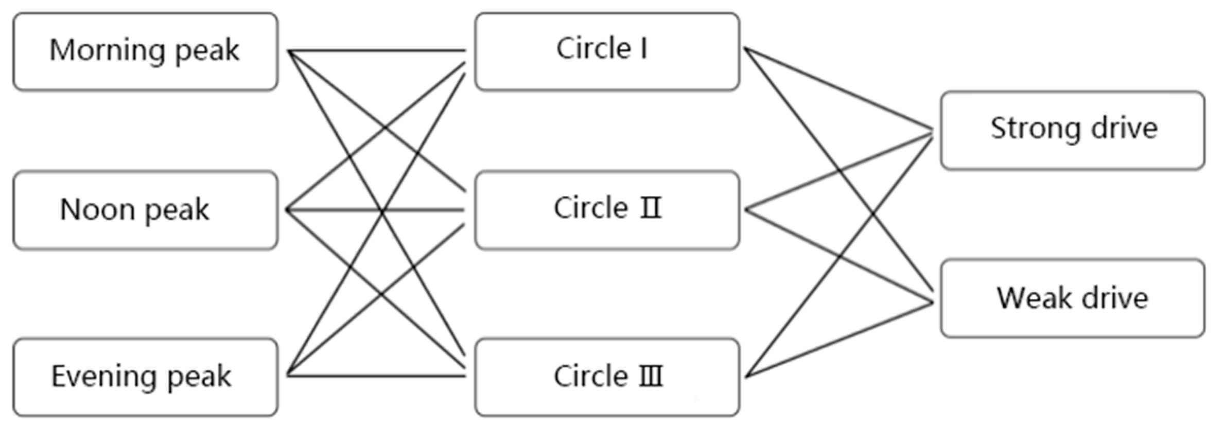
Figure 1. Indications of individual movement-state transitions.
Buildings 14 02225 g001
Figure 2. Illustration of walking paths for strong and weak driving purposes in the rail station area.
Buildings 14 02225 g002
Figure 3. Instructions for walking paths in the rail station area: (a) direct and indirect connections; (b) comprehensive pedestrian system in rail station area.
Buildings 14 02225 g003
Figure 4. Pipes, aisles, street models: (a) pipes; (b) aisles; (c) streets.
Buildings 14 02225 g004
Figure 5. Research process for the differential impact mechanism of subjective and objective factors.
Buildings 14 02225 g005
Figure 6. The interaction between subjective and objective factors: (a) perception–function matching relationship; (b) a framework for subjective and objective comparative analysis of walking decisions.
Buildings 14 02225 g006
Figure 7. Hierarchical decomposition of the built environment along the walking path.
Buildings 14 02225 g007
Figure 8. PRD and LNR calculation diagram.
Buildings 14 02225 g008
Figure 9. Site scope and functional layout of Lvcuo Station: (a) research scope of Lvcuo Station site area; (b) site functional layout of Lvcuo Station.
Buildings 14 02225 g009
Figure 10. Walking route tracking instructions.
Buildings 14 02225 g010
Figure 11. Illustration of the walking behavior data collection process in station-area streets.
Buildings 14 02225 g011
Figure 12. (a) ArcGIS 10.6 Operator Interface; (b) Preliminary construction of ArcGIS attribute database.
Buildings 14 02225 g012
Figure 13. (a) Image semantic segmentation of sample street 1; (b) Image semantic segmentation of sample street 2.
Buildings 14 02225 g013
Figure 14. Street-view image sampling instructions.
Buildings 14 02225 g014
Figure 15. Distribution of different types of walking paths: (a) family affairs, (b) work/school, (c) transportation transfer, (d) leisure and shopping, (e) domestic services, and (f) fitness workout. (The change from blue to red represents an increase in the frequency of pedestrian flow.).
Buildings 14 02225 g015
Figure 16. Travel purposes and route distribution of different age groups: (a) 15–25 years old, (b) 26–45 years old, and (c) over 45 years old. (The change from blue to red represents an increase in the frequency of pedestrian flow.).
Buildings 14 02225 g016
Figure 17. Travel purposes and route distribution by gender: (a) male and (b) female. (The change from blue to red represents an increase in the frequency of pedestrian flow.).
Buildings 14 02225 g017
Figure 18. Spatial distribution of subjective and objective interactions. (a) subjective and objective collaboration, (b) positive deviation, (c) negative deviation. (The change from light red to deep red represents an increase in the frequency of pedestrian flow.).
Buildings 14 02225 g018
Figure 19. Walking travel conditions combination.
Buildings 14 02225 g019
Figure 20. Urban activities and crowd gathering in the plaza in front of Zhongmin Baihui Mall. (a) perspective 1; (b) perspective 2.
Buildings 14 02225 g020
Figure 21. The pedestrian bridge connecting the station to the shopping center.
Buildings 14 02225 g021
Figure 22. The change in walking path options creates significant commercial premium benefits. (a) Construction preparation stage—2016. (b) Aerial bicycle path construction—2018. (c) Construction of pedestrian bridge begins—2019. (d) Construction of pedestrian integrated facility system completed—2022.
Buildings 14 02225 g022aBuildings 14 02225 g022b
Table 1. Types of behavior versus types of activity.
Type of BehaviorCharacterizationType of ActivitySubject to Environmental DisturbanceRoute Choice
Strong driveDestination accessibility efficiency as the first requirement, with clear time constraints and relatively weak attraction of other points of interest along the way.Work/school, transportation transfer, family affairsWeakRelatively fixed
Weak driveNo apparent purpose, no clear time constraints, strong attraction to points of interest along the way.Leisure and shopping, domestic services, fitness workoutStrongGenerally random
Table 2. Walking space description index.
Indicator NameCalculation Method
Walking trailsWalking path widthAverage field measurements.
Pavement qualityThe calculation method of pavement quality per unit street segment is the ratio of the walking space area after removing the damaged area of the pavement to the total area. The larger the value is, the better the quality is.
Walking continuityX = (X1 + X2 + X3 + ……Xn)/N; Xn is the walking continuity value of the nth street segment of the path; Xn = 1 − (transverse cross − sectional area/total area of street segment) × 100%.
Obstacle levelThe calculation method for a unit street segment is the ratio of the number of obstacles occupying the pedestrian space to the total area of the pedestrian path.
Shade situationThe calculation method for unit street segments is to extract color patches from satellite plans and calculate the area ratio.
Rest facilitiesCount.
Density of peopleCount.
Neighborhood designFunctional mixX = −∑(Pi × LnPi). Among them, P1 = (N1 × A1)/(N1 × A1 + N2 × A2 + …Ni × Ai) Pi is the proportion of functional facilities in the i-th street and the A and N points determine the area and number of functional buildings.
Distance from exterior edge of building along street to sidewalkField measurement.
Landscape greening levelCalculate the percentage of green area identified in street-view images.
Consumer store densityThe ratio of the total number of consumer stores (such as convenience stores, food, clothing, department stores, etc.) to the total number of facilities.
Entertainment store densityThe ratio of the total number of entertainment stores (such as KTV, chess and card rooms, etc.) to the total number of facilities.
Service store densityThe ratio of the total number of service stores (such as banks, activity centers, community studios, express delivery, hospitals, etc.) to the total number of facilities.
Window transparencyThe proportion of window display area facing the street space of shops along the street. Variables include the length of the open store interface with the facade fully opened (X1), the length of the transparent glass window interface that can directly see the interior (X2), and the length of the advertising glass window interface with product scenery (X3) (including opaque print advertisements). The weights are 1.25, 1, 0.75, and 0, in order, which are the ratios to the total length (AL) of the street facades on both sides. X = (X1 × 1.25 + X2 + X3 × 0.75)/total length of street wall facade (AL).
Activity recordCount.
Degree of surveillanceX = S people/S total; S people represents the pixel area occupied by pedestrians in the street-view image and S total is the overall pixel area.
Traffic environmentDifficulty of crossing the intersectionCalculate the waiting and crossing time as the total time and measure the crossing difficulty in minutes. Path level score total time.
Motor vehicle trafficTrack and record the average traffic volume of the street segment during the period when the target individual passes through the street.
People and vehicle isolation facilitiesThe sum of the lengths of pedestrian and vehicle isolation facilities (guardrails, green belts, etc.) for each street segment is divided by the total length of the street segment. The entire line level is the average of the street segment level.
Non-motor vehicle traffic densityTrack and record the average number of non-motorized vehicles (bicycles, electric vehicles, shared trams, etc.) that the target individual passes on the street during a period of time.
Crossing the street along the wayThe opening along the line can be calculated by the ratio of the transverse length to the length of the entire isolation fence.
The number of other types of roads that the path connects toCount.
The number of service roads connected at the end of the street segmentCount.
Path attributeThe shortest distance from the starting pointArcGIS calculation
Actual walking distance
Detour ratePRD = D1/D2; D1 is the actual walking distance and D2 is the shortest path distance calculated based on GIS.
Direction change rateR = D1/D2 (the sum of angle changes during the pedestrian’s actual walking journey divided by the sum of angle changes when following the shortest route).
Road segment node ratioLNR = Number of road segments/(number of intersections + number of end nodes at the end of the road).
Walking speedX = (X1 + X2 + X3 + ……Xn)/n. The cumulative speed Xi of each street segment is divided by the number of street segments to obtain the average speed.
Route type0 represents weak driving behavior; 1 represents strong driving behavior. (see Section 5.2 for specific event types of walking behavior)
Table 3. Subjective environmental perception items involved in existing studies.
CategorySubjective Attitude
Route preferencesThe shortest time
Shortest distance
Daily habits
Direct direction
Walking experienceGood quality sidewalk walking space
Fewer obstacles to walking
There are more recreational facilities available
Not crowded
Others choose to go on this route too
Neighborhood feelGood privacy and security
This street has people/buildings, landscapes, shops, etc. that can attract attention
There are more urban activities happening
You can see the activities inside the shops along the way
Shopping, dining, and other needs can be met along the way
Traffic perceptionConvenient to cross the street
The route does not need to pass through more roads with complex traffic environments
Good connection with other sidewalks/pedestrian streets/passages
Lower non-pedestrian traffic
Table 4. Subjective and objective interactive indicator items.
Hierarchy of NeedsReason for Route SelectionSubjectiveObjectiveObjective Descriptive Indicators
Route preferencesThe shortest time0/10/1Detour rate
direct direction0/10/1Direct rate
Walking experienceGood quality walking trails0/10/1Walking paths are uniformly wide
0/10/1Walking continuous level
0/10/1Pedestrian pavement quality
There are few facilities to hinder0/10/1Number of obstacles (trash cans, parking spaces, store signs, etc.)
There are many recreational facilities to assist walking.0/10/1Shade area ratio (shade ratio, awning, etc.)
0/10/1Rest facilities
Not crowded0/10/1Traffic density during slicing period
Neighborhood feelGood privacy and security0/10/1The distance between the building facing the street and the pedestrian path
0/10/1Crowd surveillance
High visual appeal (Internet celebrity buildings, landscapes, public art, etc.)0/10/1Density of cultural and entertainment facilities
0/10/1Greening rate level
Shopping, dining, and other needs can be met along the way.0/10/1Functional mix
0/10/1Density of consumer facilities along the street
0/10/1Window transparency
There are many activities to stop and participate in.0/10/1Number of active events along the route (occurring regularly)
Traffic perceptionCross city roads with ease0/10/1Intersection crossing level
0/10/1Crossing levels along the road
Stable walking environment0/10/1Level of isolation facilities for people and vehicles
0/10/1Non-motor vehicle traffic density
Lower traffic flow0/10/1Vehicle traffic level
0/10/1Number of other types of lanes connected at the end of the street segment
Connected to other important roads (paths connecting city squares, branch roads entering shopping malls, pedestrian streets, etc.)0/10/1Road segment node ratio
0/10/1The number of other types of roads that can be connected along the street segment
Table 5. Summary table of subjective and objective comparisons of walking paths.
Interaction MetricsFrequencySubjectiveObjectiveInteraction MetricsFrequencySubjectiveObjective
Shortest distance17711High visual appeal6011
671014410
650112801
104007800
Direct direction6511Meet consumer needs along the way11911
1211010310
153018101
710010700
Good walking quality5711City activity attraction18811
102106510
158015901
930010800
Smooth and continuous walking6511Cross city roads with ease12611
114108910
172018201
590011300
There are many walking facilities11411Stable walking environment6411
1631017110
700111601
63005900
Not crowded6811Lower non-pedestrian traffic6611
1421015710
1270112801
73005900
Good privacy and security7311Have better
connectivity
12011
117109110
136017101
840012800
Table 6. Walking travel condition combination.
Path Plan Serial NumberTravel Plan
Morning rush hour → Walk 400–700 m → Work/School
Morning rush hour → Walk 700–1000 m → Work/School
Morning rush hour → Walk 1100–1500 m → Go home
Noon rush hour → Walk 400–700 m → Family shopping
Table 7. Comparison of subjective and objective data on walking paths in various periods.
Interaction VariableProtocol Measurement Kappa ValueConsistent Decision Making (%)Positive Deviation (%)Negative Deviation (%)
Morning peakShortest distance0.366 ***74.2014.5311.27
Direct direction0.301 ***63.8712.2123.92
Good walking quality−0.086 ***40.8327.0433.13
Smooth and continuous walking−0.154 ***24.1631.1754.67
There are many walking facilities−0.053 **44.1225.7320.15
Not crowded−0.211 ***34.1438.3127.55
Good privacy and security−0.066 ***45.7021.6133.29
High visual appeal−0.232 ***33.5533.0232.43
Meet consumer needs along the way−0.141 ***37.6227.6434.74
City activity attraction−0.102 ***41.2623.0135.73
Cross city roads with ease0.103 ***39.1030.8530.05
Stable walking environment−0.247 **38.1739.7622.07
Lower non-pedestrian traffic−0.210 ***33.2044.6122.19
Have better connectivity0.392 ***81.3711.507.33
Noon peakShortest distance0.403 ***84.128.807.38
Direct direction−0.346 ***32.1126.6041.29
Good walking quality−0.043 ***49.1020.6320.27
Smooth and continuous walking−0.161 ***39.1433.3127.55
There are many walking facilities−0.017 ***46.8629.1723.97
Not crowded−0.076 ***45.2237.6817.10
Good privacy and security−0.067 ***46.1026.2927.61
High visual appeal−0.121 ***35.0635.7229.22
Meet consumer needs along the way−0.321 ***22.7318.3758.90
City activity attraction−0.234 ***34.0433.4932.47
Cross city roads with ease0.161 ***41.2223.0535.73
Stable walking environment0.084 **49.1224.0826.80
Lower non-pedestrian traffic−0.271 ***29.6223.1847.20
Have better connectivity0.411 ***85.5410.745.47
Evening peakShortest distance0.243 ***62.3620.3617.28
Direct direction0.101 *51.5016.4932.01
Good walking quality−0.398 *19.3823.5057.12
Smooth and continuous walking−0.302 **20.3337.0642.61
There are many walking facilities−0.291 ***25.0926.8848.03
Not crowded0.09031.0342.0926.88
Good privacy and security−0.287 ***24.6228.0847.30
High visual appeal0.112 ***54.3230.0917.59
Meet consumer needs along the way−0.098 *47.5516.6047.30
City activity attraction0.254 ***58.1716.4935.85
Cross city roads with ease−0.090 ***41.1639.7619.08
Stable walking environment−0.523 **11.4254.0534.53
Lower non-pedestrian traffic−0.480 ***15.2462.0922.67
Have better connectivity0.371 ***77.0317.165.81
Note: * p ≤ 0.1, ** p ≤ 0.05, and *** p ≤ 0.01 represent significance at the 10%, 5%, and 1% levels, respectively.
Table 8. Consistency analysis of circles at different distances.
Interaction VariableProtocol Measurement Kappa ValueConsistent Decision Making (%)Positive Deviation (%)Negative Deviation (%)
400–700Shortest distance0.391 ***78.0416.225.74
Direct direction0.132 ***56.3330.2113.46
Good walking quality−0.102 ***30.4218.4951.09
Smooth and continuous walking−0.114 ***27.1528.2844.57
There are many walking facilities−0.092 ***41.8016.5541.65
Not crowded−0.178 ***27.1645.8926.95
Good privacy and security−0.402 ***16.2317.6966.08
High visual appeal−0.367 **19.4123.3654.23
Meet consumer needs along the way−0.215 ***33.2426.7540.01
City activity attraction−0.341 *20.1152.0727.82
Cross city roads with ease−0.211 ***39.3132.1528.54
Stable walking environment−0.276 **30.7928.0541.16
Lower non-pedestrian traffic−0.252 ***32.0841.3326.59
Have better connectivity0.341 ***72.1113.4314.46
700–1100Shortest distance0.309 **64.1220.2015.68
Direct direction0.14633.1237.6229.27
Good walking quality−0.378 ***17.0119.7363.26
Smooth and continuous walking−0.224 **21.0340.1638.81
There are many walking facilities0.089 ***48.8230.1621.02
Not crowded−0.273 ***30.1139.9829.91
Good privacy and security−0.220 ***32.0412.8055.16
High visual appeal0.104 *36.0237.1626.82
Meet consumer needs along the way0.288 ***61.4028.0310.57
City activity attraction0.165 **45.1115.6039.29
Cross city roads with ease0.078 **46.2013.7540.05
Stable walking environment−0.144 **25.5023.5950.91
Lower non-pedestrian traffic−0.211 ***26.9132.8940.20
Have better connectivity0.287 ***60.7219.0020.28
1100–1500Shortest distance0.17630.0242.3127.67
Direct direction0.14117.658.7373.62
Good walking quality−0.056 ***17.1319.6763.20
Smooth and continuous walking−0.077 *15.0717.9267.01
There are many walking facilities0.081 **40.1115.0644.83
Not crowded−0.041 ***17.9027.8854.22
Good privacy and security−0.019 ***14.5218.0367.45
High visual appeal−0.080 ***41.1729.9328.90
Meet consumer needs along the way0.366 ***74.1117.7291.83
City activity attraction0.202 *51.0332.0716.90
Cross city roads with ease−0.127 **32.1019.8048.10
Stable walking environment0.05520.4525.4354.12
Lower non-pedestrian traffic−0.045 **15.8929.5554.56
Have better connectivity0.310 **60.0913.2826.63
Note: * p ≤ 0.1, ** p ≤ 0.05, and *** p ≤ 0.01 represent significance at the 10%, 5%, and 1% levels, respectively.
Table 9. Consistency levels of factors for different travel purposes.
Interaction VariableProtocol Measurement Kappa ValueConsistent Decision Making (%)Positive Deviation (%)Negative Deviation (%)
Strong driveShortest distance0.455 ***87.029.143.84
Direct direction0.231 **52.5526.3721.08
Good walking quality0.02016.987.9275.10
Smooth and continuous walking−0.086 ***44.2019.3636.44
There are many walking facilities−0.112 ***16.6222.3461.04
Not crowded−0.211 **16.0238.2045.78
Good privacy and security−0.544 ***13.2129.1757.62
High visual appeal0.12027.0834.1838.74
Meet consumer needs along the way−0.112 **27.1126.0846.81
City activity attraction0.401 ***77.0210.2312.75
Cross city roads with ease0.143 ***54.3413.6931.97
Stable walking environment−0.202 **17.8126.5430.14
Lower non-pedestrian traffic−0.264 ***19.5329.7850.69
Have better connectivity0.389 ***70.0312.3417.63
Weak driveShortest distance0.067 *17.3359.4623.21
Direct direction−0.232 **15.8857.3926.73
Good walking quality−0.566 **13.0640.1146.83
Smooth and continuous walking−0.44211.2142.0846.71
There are many walking facilities0.217 ***48.4627.2124.33
Not crowded−0.370 ***32.3139.1828.51
Good privacy and security−0.302 **38.9320.3740.70
High visual appeal0.221 **50.4714.4735.06
Meet consumer needs along the way−0.244 **14.0218.4867.50
City activity attraction0.118 ***30.2328.0641.71
Cross city roads with ease−0.311 **62.0810.1127.81
Stable walking environment−0.184 ***17.0942.1240.79
Lower non-pedestrian traffic−0.578 **11.2066.0222.78
Have better connectivity0.212 ***57.0210.2127.77
Note: * p ≤ 0.1, ** p ≤ 0.05, and *** p ≤ 0.01 represent significance at the 10%, 5%, and 1% levels, respectively.
Table 10. One-way logistic regression.
BExp (B)Degrees of FreedomSignificance (p)95% Confidence Interval for EXP (B)
Lower LimitUpper Limit
Route distance
Direction of travel
Walking trail quality1.1403.12610.0002.0734.717
Smooth and continuous walking−0.3180.72710.1380.4771.108
Support pedestrian facilities−0.361 ***0.69710.027−0.5545.902
Not crowded0.4831.62010.3800.2542.153
Privacy and security0.2811.32510.1670.0420.824
visual appeal.1.011 **2.74810.0001.0254.076
Meet consumer needs along the way−0.179 ***0.83610.023−0.2342.462
City activity attraction0.717 **2.04810.0410.3190.994
Cross city roads with ease0.845 ***2.32810.0001.6056.467
Stable walking environment1.0562.87510.0011.5624.033
Lower non-pedestrian traffic−0.9660.38010.0000.2430.595
Have better connectivity1.446 ***4.24610.0001.0215.769
Note: ** p ≤ 0.05, and *** p ≤ 0.01 represent significance at the 5%, and 1% levels, respectively.
Table 11. Multifactor logistic regression (the first part).
The perceived synergy is recorded as (0), the positive deviation is recorded as (1), and the negative deviation is recorded as (2). The perceived synergy is used as the reference group.
Explanatory VariablesShortest DistanceDirect DirectionWalking QualityEasy to WalkSupport Pedestrian FacilitiesNot CrowdedShortest Distance
12121212121212
Age
15–25 years old
26–45 years old0.688 **0.421 **1.171 ***0.714 ***0.824 ***0.408 **0.1130.186 **0.723 **0.351 *1.154 **0.247 **1.504 ***0.620 **
Over 46 years old−0.367 *−0.762 *−0.254−0.426 **−0.549 **−0.315 **0.362 **0.243 ***0.094 **1.120 *0.7761.0411.0220.326 *
Gender
11.223 ***−0.720 ***1.020 ***0.0630.801 **0.922−1.451 **−1.026 *−1.021 **−0.630 *0.216 **0.419 *0.834 *0.530 ***
0
Education level
High school, junior college, and below
Bachelor degree and above0.811 *0.452 *0.3260.2900.565 **0.209 *0.736−0.642 *0.404−0.7731.055−0.546 *0.7430.611
Individual/family income (year)
Less than RMB 100,000
100,000–200,000 RMB0.5010.9171.4050.8051.5780.711 **1.5250.813 ***1.578 *0.9131.5250.8130.1130.457
More than 200,0000.639 *0.209 *0.3180.6600.422 *0.223 *0.342 *0.667 *0.5030.2790.4220.3010.4050.654
Do you have a driving license?
Yes0.603 **0.458 **0.6130.3390.437−0.313−0.616 **−0.702 *−1.276 **0.786 *0.7620.6101.6511.424
No
Select motor vehicle travel frequency
Occasionally1.241 ***0.2620.985 **0.732 **0.726 *1.026 *1.121 ***0.533 *0.468 ***0.6190.475 ***0.4451.667 ***0.313
Generally0.886 ***0.4510.833 ***0.510 **0.507 *0.414 **0.414 **0.126 *0.3110.4200.310 **0.2760.774 **0.604
Frequently
Years of residence in this city
In less than a year
2–5 years0.472 ***0.271 **0.275 ***0.232 **0.4260.0741.022 ***0.5330.4680.6190.3060.3500.7680.511
More than 5 years0.80 3***0.164 **0.569 ***0.410 **0.612 **0.4230.414 **0.1270.3110.4030.4100.2760.4060.322
Weather conditions affect travel
Yes1.043 **0.568 ***0.704 ***0.631 **0.511 ***0.102 *1.043 **0.620 ***0.577 ***1.083 **1.015 ***0.665 **1.776 ***0.665 **
No
Note: * means p ≤ 0.1, ** means p ≤ 0.05, and *** means p ≤ 0.01, representing significance at the 10%, 5%, and 1% levels respectively. The mark “—” indicates that the explanatory variable is the reference group.
Table 12. Multifactor logistic regression (the second part).
The perceived synergy is recorded as (0), the positive deviation is recorded as (1), and the negative deviation is recorded as (2). The perceived synergy is used as the reference group.
Explanatory VariablesGood Privacy SecurityLower Non-Pedestrian TrafficBetter ConnectivityConsumption Needs Can Be Met along the WayActivities AvailableCross City Roads with EaseStable Walking Environment
12121212121212
age
15–25 years old
26–45 years old1.0660.532 *0.446 **−0.722−1.367 ***0.4800.662 **0.157 ***1.026 **0.762 ***0.548 *0.1250.554 ***0.326 *
Over 46 years old0.6310.164 *0.801 **−0.6200.911 **0.2030.320 *0.031 ***0.6810.4730.2510.0870.830 *0.028
gender
1−0.725 ***−0.532 ***−1.446 **−0.657 **0.541 ***0.432 *−1.754 ***−0.561 ***0.613 **1.138 **0.681 **0.223−1.330 **−0.676 *
0
Education level
High school, junior college, and below
Bachelor degree and above0.3620.2570.4150.290 *0.5650.4020.407 *−0.3200.427 *−0.622 *1.074−1.251 **0.536−0.621
Individual/family income (year)
Less than RMB 100,000
100,000–200,000 RMB−0.621−0.407−1.02−0.4020.710 ***0.4200.140 ***−0.2290.340 **1.1820.6810.250−1.011 *−0.589
More than 200,000−0.553−0.682−1.44−0.6570.902 **0.4561.223 ***−0.364 *0.795 *1.5290.4200.541−1.510 **−0.024
Do you have a driving license?
yes1.4511.0300.878 **0.562 *1.042 ***0.3561.138 ***0.147 **1.175 **0.470 **1.005 **0.257 *0.761 ***0.450
no
Select motor vehicle travel frequency
Occasionally1.4221.0161.335 ***0.5261.431 ***0.220 *0.782 **0.422 **1.121 **0.6521.015 **0.6600.6550.361
Generally0.5100.4031.120 **0.2100.566 ***0.6370.531 **0.360 *1.220 ***0.5301.038 ***0.4331.112 **0.550
Frequently
Years of residence in this city
In less than a year
2–5 years0.6210.3300.7820.2210.6230.1080.234 **0.426 **0.5420.6540.420 *0.520 *0.2110.437
More than 5 years1.1550.7281.0220.5420.2110.0420.665 ***0.588 **0.2060.7780.657 ***0.601 **0.430 **0.720
Weather conditions affect travel
Yes0.574 **0.420 **1.22 2 ***0.567 **0.106 *0.4120.680 ***0.5021.041 **0.723 *1.1100.4431.1250.567
No
Note: * means p ≤ 0.1, ** means p ≤ 0.05, and *** means p ≤ 0.01, representing significance at the 10%, 5%, and 1% levels, respectively. The mark “—” indicates that the explanatory variable is the reference group.
Disclaimer/Publisher’s Note: The statements, opinions and data contained in all publications are solely those of the individual author(s) and contributor(s) and not of MDPI and/or the editor(s). MDPI and/or the editor(s) disclaim responsibility for any injury to people or property resulting from any ideas, methods, instructions or products referred to in the content.

