Article

Impact of the September 2023 Storm Daniel and Subsequent Flooding in Thessaly (Greece) on the Natural and Built Environment and on Infectious Disease Emergence

by
Spyridon Mavroulis
1,*,
Maria Mavrouli
2,
Efthymios Lekkas
1 and
Athanasios Tsakris
2
1
Department of Dynamic Tectonic Applied Geology, Faculty of Geology and Geoenvironment, School of Sciences, National and Kapodistrian University of Athens, 15784 Athens, Greece
2
Department of Microbiology, Medical School, National and Kapodistrian University of Athens, 11527 Athens, Greece
*
Author to whom correspondence should be addressed.
Environments 2024, 11(8), 163; https://doi.org/10.3390/environments11080163
Submission received: 18 June 2024 / Revised: 26 July 2024 / Accepted: 30 July 2024 / Published: 2 August 2024

Abstract

:
The storm Daniel and subsequent floods hit the Region of Thessaly (Greece) in early September 2023, causing extensive damage to the built environment (buildings, networks, and infrastructure), the natural environment (water bodies and soil), and the population (fatalities, injured, homeless, and displaced people). Additionally, the conditions and factors favorable for indirect public health impact (infectious diseases) emerged in the flood-affected communities. The factors had to do with infectious diseases from rodents and vectors, injuries, respiratory infections, water contamination, flood waste and their disposal sites as well as structural damage to buildings and the failures of infrastructure. The conditions that evolved necessitated the mobilization of the Civil Protection and Public Health agencies not only to cope with the storm and subsequent floods but also to avoid and manage indirect public health impact. The instructions provided to affected residents, health experts, and Civil Protection staff were consistent with the best practices and lessons learned from previous disasters. The emphasis should be on training actions for competent agencies, as well as education and increasing the awareness of the general population. Non-structural and structural measures should be implemented for increasing the climate resilience of infrastructures including the health care systems within a One Health approach.

1. Introduction

Hydrometeorological hazards comprise a wide range of events, mainly floods, storms, droughts, and temperature extremes along with their cascading effects [1]. Despite their atmospheric, hydrological, or oceanographic origin, they can have a considerable impact on hazards of different types, such as biological health hazards (e.g., infectious disease outbreaks and epidemics). Hydrometeorological hazards are characterized by a high potential to adversely affect the structural environment including buildings and infrastructures, but also negatively impact public health [2].
Based on the disasters recorded in 2022 by the Emergency Events Database (EM-DAT), the international disaster database maintained by the Centre for Research on the Epidemiology of Disasters (CRED) and the World Health Organization (WHO), hydrometeorological hazards hold top positions [3]. Floods hold the first place with 176 events, storms the second with 108 events, and fires the fourth with 15 events, just behind earthquakes which are in third place [3]. In fact, the above hydrometeorological disasters in 2022 have exceeded the averages in the previous 20 years (2002–2021). More specifically, 8 additional floods (176 vs. 168), 4 additional storms (108 vs. 104), and 4 additional fires (15 vs. 11) were recorded [3]. This increasing trend is shown not only in the number of recorded events but also in the number of human casualties. For floods in particular, human losses in 2022 amounted to 7954 compared to 5195, which is the 20-year average for 2002–2021 [3]. In addition to human losses, an increasing trend is also shown in the economic losses from all the hydrometeorological events, including floods and storms. Economic losses from floods amounted to USD 44.9 billion in 2022 compared to USD 41.6 billion, which is the average for the previous 20 years [3]. For storms, the associated economic losses for 2022 amounted to USD 131 billion, surpassing the average of USD 90.2 billion for the previous twenty years.
This increasing trend in the frequency and severity of hydrometeorological phenomena has been already observed in Greece. The country has been affected in recent years by intense storms and subsequent floods with significant impacts on the natural and built environment and consequently, on the population. A typical example is the Mediterranean cyclone (medicane) “Ianos” in early September 2020 [4]. It triggered many phenomena and impacts, which can be grouped into 3 categories and 39 subcategories in the inland and coastal areas, ranging from flooding and geomorphological phenomena to damage to various facilities, vehicles, and infrastructure [4,5].
The “Ianos” medicane occurred in the midst of the evolving COVID-19 pandemic, more specifically when the second wave was gradually developing. Its impact on the evolution of the pandemic in the affected regions and regional units was significant [6]. The number of COVID-19 cases increased in the post-medicane period in the affected regions [6]. This increase has been attributed to the synergy of the pre-existing viral load, the intensity of the events, and the adverse conditions in the affected areas, as well as the contradictions between the flood impact management actions and measures to limit the new virus spread in the affected communities [6].
Extreme weather events hit central Greece again, especially the Region of Thessaly, from 4 September to 8 September 2023. The storm Daniel was characterized by heights among the largest recorded in the region and by a very large spatial distribution comprising the regional units of Magnesia, Karditsa, Trikala, and Larissa of the Thessaly Region [7] (Figure 1). The phenomena were characterized by the occurrence of flash floods in small catchments, such as in the area of Volos city (Figure 1). Furthermore, they also included river flooding from the overflow of the Pineios River and its tributaries. These floods affected important cities of the Thessaly Region, including Larissa (Figure 1), and dozens of settlements in the Thessalian Plain [7].
These destructive events resulted in 17 fatalities in the affected areas [7]. Apart from the direct impact on human life, these events revealed another real and particularly serious public health risk: the risk of infectious disease emergence during storm recovery.
Adverse conditions due to disasters caused by natural hazards commonly comprise the following: (i) the destruction of critical infrastructure and lifelines; (ii) the lack of drinking water and water supply from contaminated sources such as wells, fountains, and boreholes; (iii) the direct exposure of sewage-contaminated floodwater; (iv) the proliferation and sudden increase in mosquito and rodent populations. These conditions are characterized by a high potential to cause further public health impacts [2,8,9], including sporadic cases, outbreaks, and epidemics in the disaster-affected communities and the surrounding areas.
Figure 1. The location map of the Thessaly Region with its regional units of Larissa, Magnesia, Trikala, and Karditsa affected by the storm Daniel and its subsequent flooding. The Thessalian Plain is divided into two smaller plains: the Larissa Plain (LP) in the east and the Karditsa Plain (KP) in the west. Both plains bounded by mountains were severely affected by the early September 2023 destructive events. The flood extent was provided by the Copernicus Emergency Management Service (EMS) Rapid Mapping on 9 September 2023 [10]. TG: Thermaikos Gulf; PG: Pagasitikos Gulf; PM: Pelion Mt; MM: Mavrovouni Mt; OSM: Ossa Mt; OLM: Olympus Mt; AMS: Antichassia Mts; ZM: Zakros Mt; TM: Titanos Mt; CM: Chalkidonio Mt; KL: Karla Lake. Sources of the basemap: Esri, DigitalGlobe, GeoEye, Earthstar Geographics, CNES/Airbus DS, USDA, USGS, AeroGRID, IGN, and the GIS User Community.
Environments 11 00163 g001
The aim of this research is to highlight all the risk factors that favor the occurrence of infectious diseases in the area affected by the storm Daniel and the subsequent flooding. This is achieved not only by taking into account the significant results of the existing relevant research on the effects of hydrometeorological events in affected areas, but also by mainly presenting field data obtained from field surveys during and after the event. In addition, this research aims to provide an important tool for all those involved in preventing, controlling, and managing potential infectious disease outbreaks during the pre-, co-, and post-disaster phases.
In this context, a list of the emergency prevention and management measures taken by the relevant Civil Protection and Public Health services is presented. These measures are essential for responding to the emergency and managing the impact of the storm and subsequent flooding on public health. They also constitute part of a multi-hazard approach, which has become a common strategy in recent years on a global scale due to the co-existence and collision of different types of hazards. The simultaneous occurrence or parallel evolution of hazards of different types (geophysical, hydrometeorological, and biological among others) has highlighted incompatibilities between the actions to mitigate the impact of natural hazards and measures to limit the evolution of biological hazards in the affected communities [6]. It also emphasized the importance of adopting the multi-hazard approach in response and emergency management [11].

2. Methodology

The methodology applied for detecting and highlighting the risk factors favoring the emergence of a health crisis in the flood-affected Thessalian plain comprises the collection of disaster-related observations and information during post-event field surveys conducted by the authors. The collected data refer to the flood impact on the various elements of the affected areas, including water bodies, farmlands, agricultural and livestock units, critical facilities and lifelines, buildings, and infrastructure among others.
The collection of related data was applied to many segments of the flood-affected Thessalian Plain including not only villages in rural areas, but also large urban centers, with populations ranging from hundreds to thousands of people. The largest affected cities visited by the researchers are Larissa, Volos, Trikala, and Karditsa (Figure 1), which are the capital cities of the respective regional units.
The collected data were then evaluated by all the authors based on the lessons learned from similar destructive hydrometeorological events generated worldwide. The risk factors prevailing in the affected area that may favor the emergence of infectious diseases were recognized. Then, the measures adopted by the Civil Protection and Public Health authorities of Greece are presented and evaluated based on similar past cases of the prevention and management of flood events and their potential impacts on public health worldwide. Proposals for increasing the resilience of the affected infrastructure to the impact of climate change are also presented, with emphasis on the health care systems in the frame of the collaborative and interdisciplinary One Health approach.

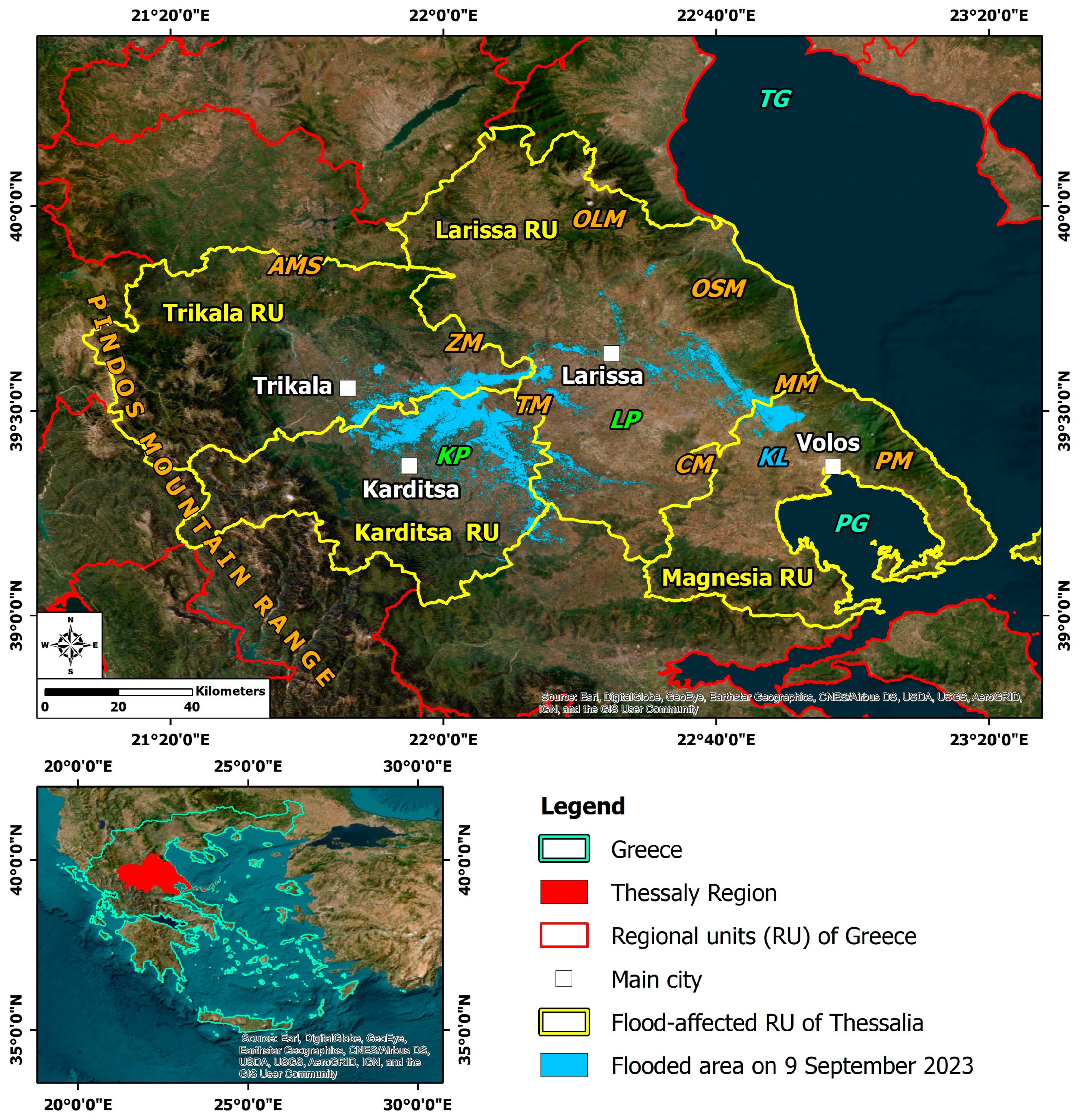
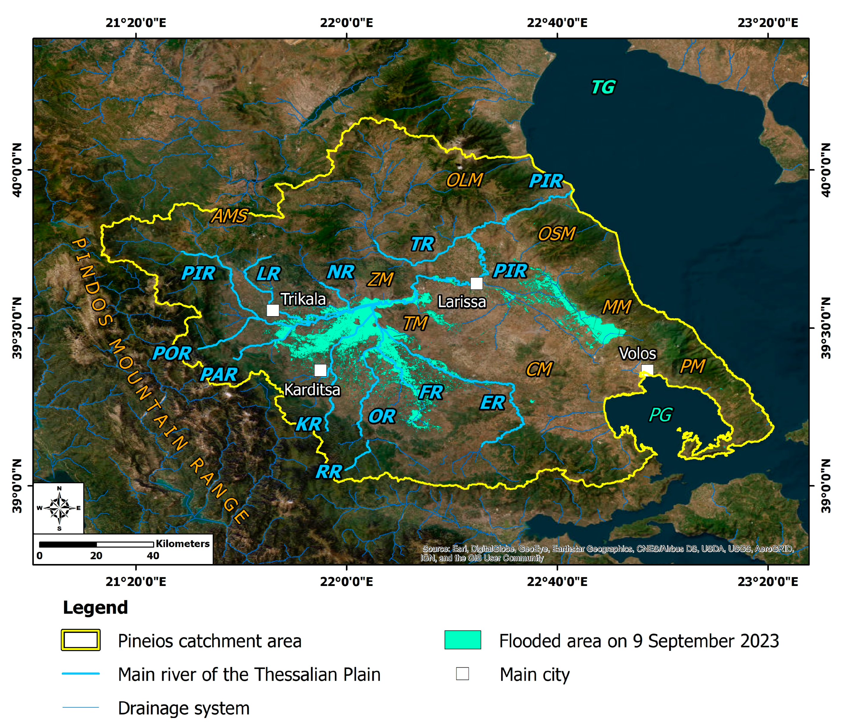
3. Location and Geological Structure of the Region of Thessaly and Disaster Inventory

The Region of Thessaly is located in the central part of Greece (Figure 1). It is an area where the geological and geomorphological characteristics make it prone to both geophysical hazards (e.g., earthquakes) [12,13,14,15] and hydrometeorological phenomena (e.g., rainfall and subsequent flooding and landslides) [4,7,16,17].
The eastern part of the Region of Thessaly comprises the Larissa Plain, within which the cities of Larissa and Volos are developed to the north and south, respectively. It is bounded by mountains from almost all directions, including the Kato Olympus and Ossa mountains to the north, Mavrovouni Mt to the east, Pelion Mt to the southeast, and Chalkidonio Mt to the southwest (Figure 1 and Figure 2). Titanos Mt is the boundary of the Larissa Plain to the west. West of the Larissa Plain, the plain of Karditsa hosts the Trikala, Karditsa, and Sofades cities from north to south, respectively (Figure 1 and Figure 2). The Karditsa Plain is also bounded by mountains, such as the Antichassia Mts in the north, Zarkos Mt in the northeast, and the Pindos mountain range in the west (Figure 1 and Figure 2). The plains have been filled with recent deposits derived from the synergy of the uplift of the adjacent mountains and the weathering and erosion processes [18,19] (Figure 2).
From the hydrological viewpoint, this area is a part of the large PCA, with an area of about 9500 km2, and the main Pineios River is the third longest among the rivers in Greece, with a total length of 205 km. The main tributaries of Pineios River [20] are presented in Figure 2.
This region is prone to hydrometeorological events, mainly floods, with severe impacts on networks, infrastructure, and buildings in urban and rural areas and fields [7,21]. A rich flood inventory in the region, presented by Lekkas et al. [7], reveals that the occurrence of such events in Thessaly is not unprecedented. This inventory includes 10 historical floods from 1684 to 1900, which have mainly affected Larissa city, and 10 floods from 1902 to 2020 with significant impact on the population; built and natural environment of Larissa, Trikala, and Karditsa cities; and other parts of the Thessalian Plain. It is important to mention that the most devastating and deadly flood in Greece was caused in 1907 by the overflow of a Pineios tributary, the Lithaios River, which flows through Trikala city, and caused more than 300 fatalities [7,21,22,23]. Furthermore, the October 1994 flood generated after a storm and affecting several rural areas and villages has been considered as one of the most destructive recent events in the Thessalian Plain [24].

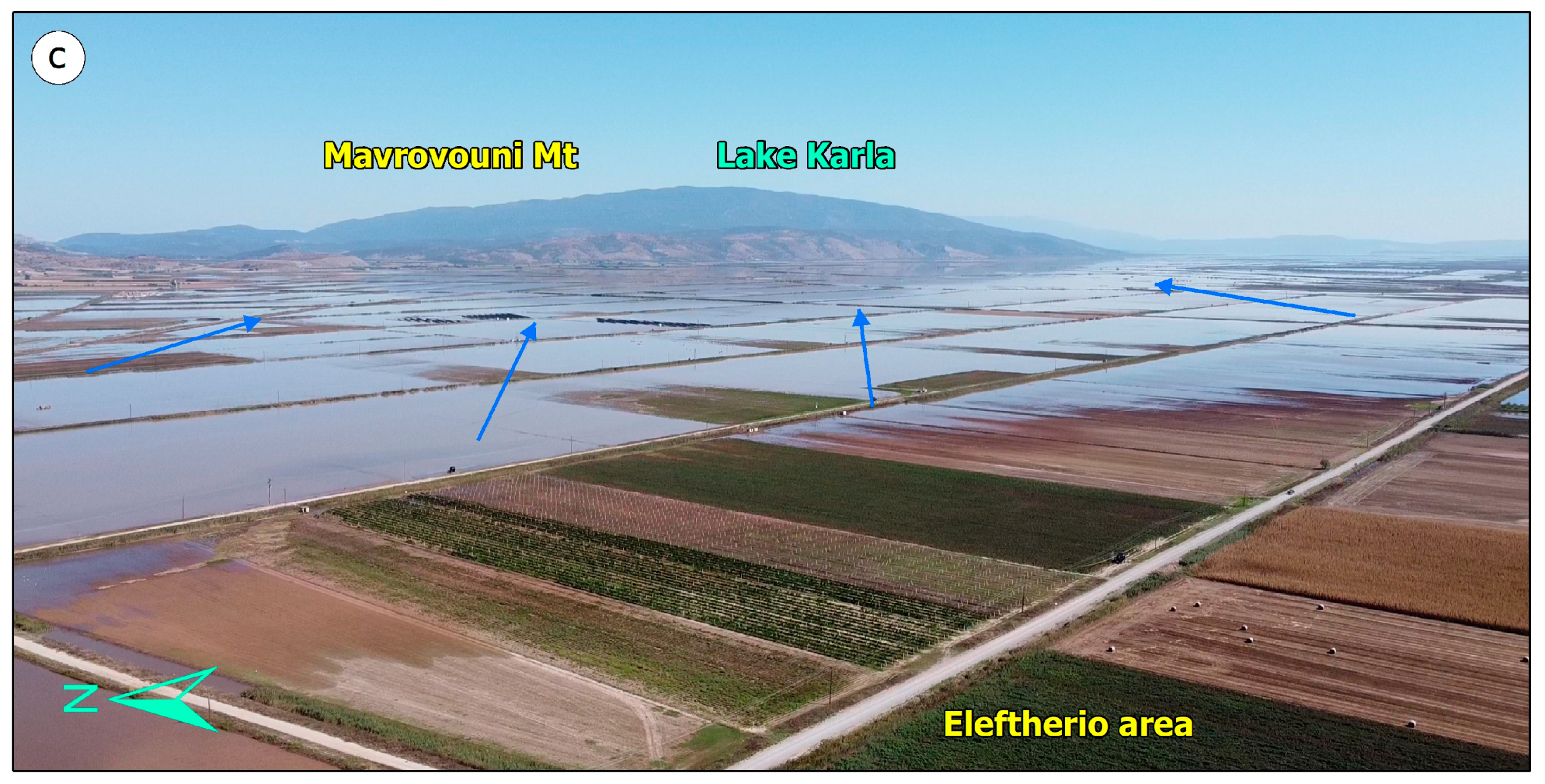
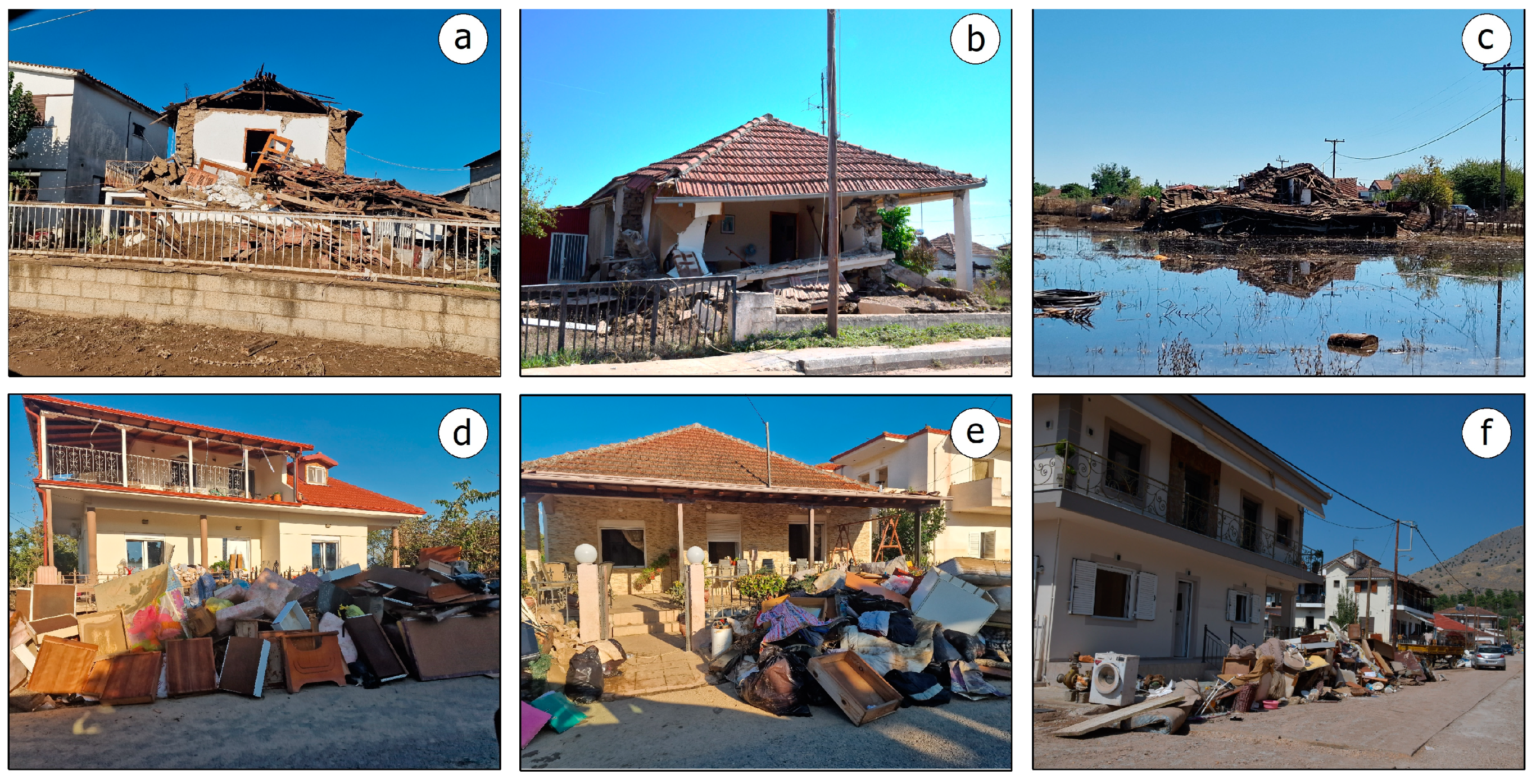
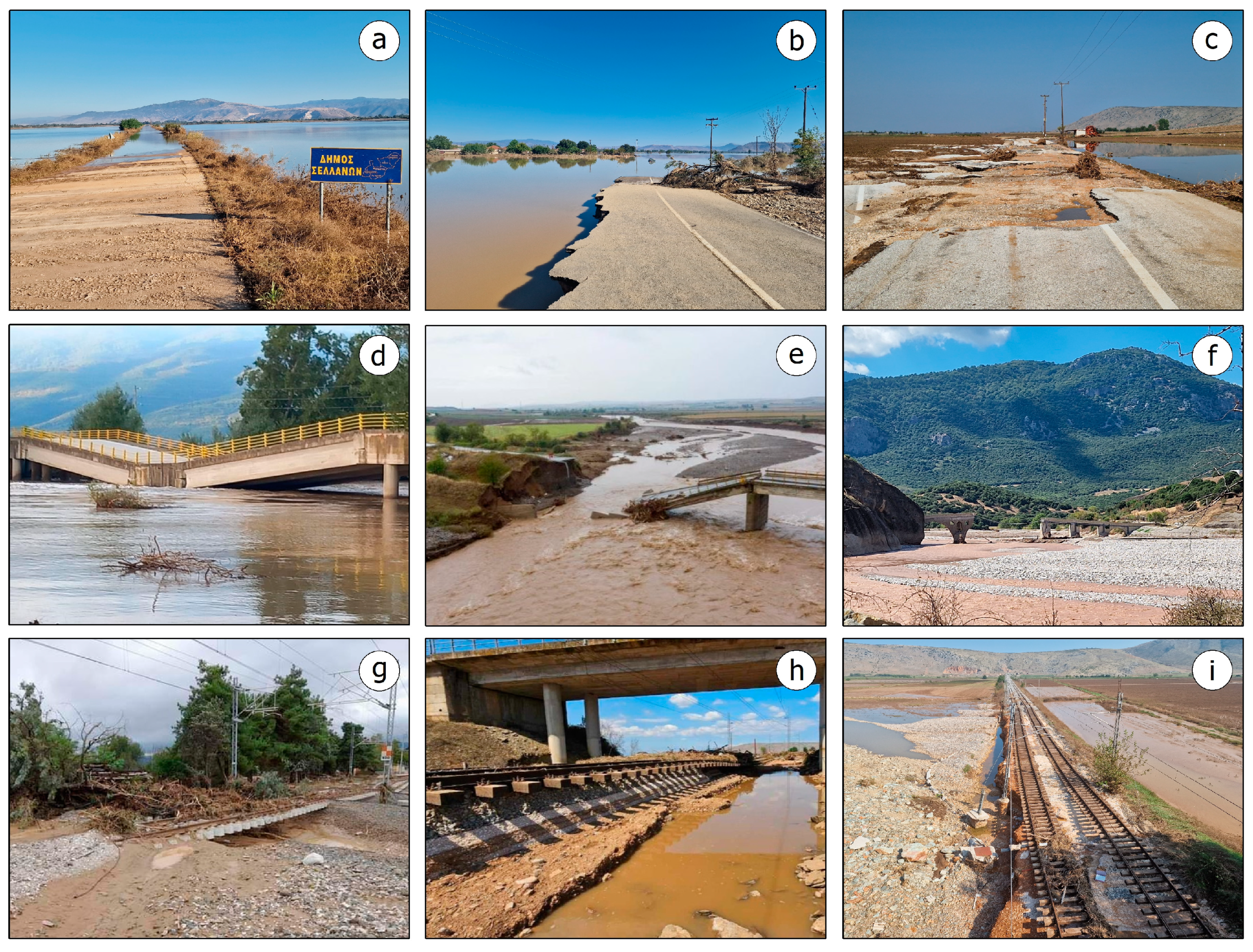
4. The Storm Daniel and Its Impact on the Natural and Built Environment

In early September 2023, Europe came under the influence of an omega blocking pattern, which resulted in extreme weather conditions in many countries. This omega block was characterized by a long period of extreme temperatures during September in the western part of Europe, which lays below the central part of the omega blocking pattern. In contrast, huge precipitation was recorded in the Iberian and Balkan peninsulas corresponding to the two large and deep upper lows on either side of the omega block [25,26].
The storm Daniel, partly attributed to this pattern, eventually created persistent and heavy rainfall in the Thessaly Region, marking some of the most significant daily rainfall totals observed over time from 4 to 7 September 2023 [26,27]. Comparing the total precipitation levels in Thessaly during the storm Daniel [27] with those recorded during the medicane Ianos that hit the country between 17 and 20 September 2020, it is noted that much higher or multiple precipitation levels were recorded in the Daniel case [28,29].
As a result of this extreme rainfall, the ability of the rivers and streams to drain the area was exceeded, resulting in their overflowing. At the same time, the intense morphology of the area surrounding the Thessalian Plain created rushing torrents, causing erosion, subsidence, and mudflows upstream and extensive flooding downstream [7].
The extreme values of precipitation in such a short time period resulted in the multiple failures of embankments in the main rivers and tributaries in the PCA, which caused extensive flooding (Figure 3) with floodwater reaching up to 4 m in many areas [7] (Figure 4). Many rural areas in the central and the northern part of the Thessalian Plain remained below flood water for several days [7]. The water continued its natural flow towards the Pineios River and ended up partly in Lake Karla and the Pineios estuary in the Aegean Sea (Figure 2), creating a new relief in the river delta [7].
In the central part of Greece, this hydrometeorological event claimed the lives of 17 people [7]. At the same time, the factors described above were combined in different ways in the Region of Thessaly. They resulted in extensive and considerable damage and the failure of structures and infrastructures, such as road cuts, bridge collapses, and damage to critical infrastructure and lifelines as well as residences, agricultural land, livestock and craft-industrial facilities, and tourist infrastructure [7].

5. Risk Factors for Infectious Diseases Emergence in the Flood-Affected Thessaly and Impact on Public Health

The above weather conditions in the Region of Thessaly, the subsequent floods, and their impacts had the potential to affect public health and, in particular, to cause sporadic cases, outbreaks, and epidemics of infectious diseases in the affected area. This adverse impact has also been detected after the onset of previous floods and other hydrometeorological hazards, not only in developing, but also in developed countries [2]. In this section, we will review the mechanisms by which floods and their effects on the natural and built environments can lead to the emergence of biological hazards in the affected areas and how these factors control the emergence and evolution of infectious diseases in the flood-affected Thessalian Plain.

5.1. Rodent-Borne Infectious Diseases

Impacts on the natural environment caused during heavy rainfall and the subsequent flooding and emergency response and recovery actions can further affect rodent demography. Severe and widespread flooding can lead to overflowing sewers and the destruction of previous rodent nesting sites [30]. The migration of rodents in search of new shelter may occur on dry land either within the flooded areas or in the surrounding unaffected areas, where ideal conditions for nesting, such as the accumulation of flood waste, have been established [31].
The management and removal of flood waste can again lead to the disturbance of rodent-preferred habitats and may increase the contact of pathogen-infected rodents not only with the flood-affected residents but also with the staff involved in emergency response and disaster management [32,33,34].
Humans can become infected with Leptospira spp. through either direct contact with an infected animal (rats, and domestic and wild animals) or through indirect contact via surface water or soil contaminated with the infected animal’s urine [35,36].
Globally, extreme weather events and flooding have been associated with leptospirosis outbreaks [37,38,39,40,41,42]. The outbreaks and sporadic cases of this spirochetal zoonosis have been associated with flood occurrence in a number of European nations, including Bulgaria, the Czech Republic, Italy, Germany, Austria, France, and Denmark.
The typical examples of leptospirosis outbreaks from the above countries are included in the review conducted by Mavrouli et al. [2], which found that among the most important risk factors for the occurrence of this rodent-borne disease in flood-affected areas are the following: (i) living in flooded areas; (ii) sudden increase in rodent populations after flooding; (iii) direct contact with infected animal hosts such as rodents, pets, and livestock, (iv) direct contact with floodwater or soil contaminated by the urine of infected animals; (v) the improper and poor waste management and accumulation of flood waste; and (vi) failure to use personal protective equipment (PPE) during post-flood cleanup activities.
In the flooded Thessaly Plain, according to the Newsletter of the National Public Health Organization (NPHO) published on 30 May 2024 [43], between 5 September and 31 December 2023, 296 of the patients who visited the hospitals of Thessaly were evaluated with the clinical suspicion of leptospirosis and 45 (15.3%) of them were laboratory confirmed. The incidence of leptospirosis cases was significantly higher (6.5/100,000) compared to the historical data of the last 10 years for Thessaly and the corresponding period (average number of cases: 0.13/100,000) (p < 0.001) [43]. In the majority of patients (86.8%) Leptospira kirscnheri was detected, while in the remaining patients, Leptospira interrogans was identified. Severe disease with typical symptoms occurred in 100% of the patients infected with L. interrogans, but only in 53.1% of those infected with L. kirschneri (no clinical information was available for one patient) [43]. Two patients with L. interrogans infection lost their lives. Exposure in a flooded environment was documented for 36 patients (80.0%) [43]. Leptospirosis is considered to be an occupational disease since it is associated with people who have worked as farmers, veterinarians, miners, military personnel, and sewer workers [44]. Thus, it is usually diagnosed in people with frequent exposure to outdoor environments (e.g., flooded areas), those having direct or indirect contact with livestock and rodents, or those doing farm work. Staff involved in search, rescue, and recovery actions (members of rescue teams, firefighters, and volunteers among others) in the flood-affected areas of the Thessalian Plain came into direct contact with contaminated water, soil, or mud and were at great risk of contracting the disease. High-risk occupation or employment as the sole factor of exposure to these spirochetes was identified in 8.9% of the cases, while no obvious source of exposure was found in 11.1% of the patients [43].

5.2. Vector-Borne Infectious Diseases

Vector-borne diseases are caused by viruses, parasites, and bacteria that are transmitted by vectors, which are usually blood-sucking insects such as mosquitoes [45].
Rainfall above average can lead to a dramatic increase in the number of mosquito breeding sites, higher mosquito abundance, and the increased likelihood of disease outbreaks [46], as it affects the pathogen transmission dynamics in the local ecosystem [47]. According to the study by Soverow et al. [47], heavy rainfall (≥50 mm in a single day) correlates with a higher incidence of West Nile Virus (WNV) in the United States.
In a study on the onset of the WNV infection in horses in Europe during the spring and summer of 2010, it was found that the weather in the cities of Trapani (Sicily, Italy), Campobasso (Molise, Italy), and Thessaloniki (Macedonia, Greece) was wetter than usual in July. This rainfall contributed to an increase in the availability of standing water, which is an ideal breeding ground for mosquitoes [48].
In Europe, flooding following extreme rainfall has been mainly associated with the emergence and increased incidence of WNV, Chikungunya virus (CHIKV), and Tahyna virus (TAHV) in Romania, the Czech Republic, Greece, Italy, and France [2,49,50,51,52,53,54].
Southeast Romania witnessed an unparalleled outbreak of WNV meningoencephalitis in the summer of 1996, which was associated with certain features of residential properties [49]. The synergy of mosquito presence indoors and basements flooded with water contaminated by sewage created an environment with a high concentration of organic matter, ideal for mosquito breeding [49].
In July 1997, the Morava River in Moravia (Czech Republic) experienced catastrophic flooding due to heavy rainfall. The sudden increase in mosquitoes carrying arboviruses, such as WNV and TAHV, led to the detection of confirmed and probable cases of WNV infection in the flood-affected area [50].
A WNV infection outbreak was recorded in Central Macedonia of northern Greece in the summer of 2010. Danis et al. [52] observed that 2010 was particularly warm and wet compared to the previous years and that abnormal precipitation occurred prior to the WNV infection.
To assess the impact of the storm Daniel on the evolution of WNV in the affected region of Thessaly, the weekly epidemiological surveillance reports of WNV infection published by the NPHO were used. The reports from 22 August to 5 December 2023 [55], which are freely accessible on the organization’s website, summarize the registration of the laboratory-diagnosed cases of WNV infection each week for the transmission period 2023.
From the aforementioned data, the following can be concluded for the evolution of WNV infection in the flooded areas of the Region of Thessaly:
  • From 18 October to 5 December 2023, no laboratory-confirmed cases of WNV infection were recorded in the affected Region of Thessaly.
  • In Mouzaki, Palamas, and Sofades Municipal Units of the Karditsa Regional Unit and in the Farsala Municipal Unit of the Larissa Regional Unit, no new cases of WNV infection were recorded from 30 August to 5 December 2023. As shown by the mapping of the flooded area from the activation of the Copernicus Emergency Management Service [10], the lowland areas of these municipalities, especially the Palamas Municipal Unit, were already flooded on 13 September and remained so for many days later until the beginning of October and the final receding of the event.
  • The largest increase in WNV cases was observed in the Larissa and Trikala Municipal Units. It was of the order of 8 and 10 cases, respectively, from 30 August to 17 October 2023. These areas were affected by flooding caused by the overflow of the Pineios and Lithaios Rivers in Larissa and Trikala, respectively.
These records do not reveal a considerable and unprecedented increase in the number of WNV cases, or an increasing effect of rainfall and flooding on the evolution of WNV infection in the flooded Thessaly Plain.

5.3. Infectious Diseases from Injuries (Tetanus)

Clostridium tetani spores are found in soil, in human and animal feces, and on rusty object surfaces. Exotoxin-producing bacteria cause tetanus, a severe nervous system disease, especially in people who have not been adequately immunized with tetanus toxoid-containing vaccines (TTCVs) [56].
Outbreaks and epidemics of tetanus have been documented after disasters, particularly after the occurrence of geophysical hazards, especially earthquakes and subsequent tsunamis. Based on the review by Mavrouli et al. [57] on the public health impacts of earthquakes and their secondary effects and the evaluated reports [58,59,60,61], tetanus epidemics were recorded in Indonesia in January 2005 following the tsunami triggered by the strongest earthquake on 26 December 2004 and after the earthquakes in Kashmir on 8 October 2005, in Yogyakarta (Indonesia) on 27 May 2006, and in Haiti on 12 January 2010.
Tsunami may belong to a different category of hazards from floods (geophysical and hydrometeorological hazard, respectively), but they share common features in their evolution that can be exploited in the case of floods and in research on their public health impact.
In a flooded area, the risk of infection by the bacterium C. tetani is high. Flood water can carry various debris and sharp objects, which can cause wounds to the human body. Wild animals carried by the flood water can come into contact with humans and bite them. Wounds caused by sharp objects or animal bites can constitute an entry point for C. tetani into the skin and lead to tetanus. This risk is real not only for those affected by the flood and its adverse effects, but also for all those activate in the field and involved in disaster management.
As mentioned earlier, tetanus can be easily prevented with a highly effective vaccine. This was also the case in the flood-affected region of Thessaly. The vaccination of those involved in managing the effects of the disaster and especially of the staff involved in search, rescue, and recovery actions in the disaster field (mainly firefighters, rescuers, volunteer firefighters, volunteers, and staff of the Region of Thessaly among others) started on 16 September 2023 [62], a few days after the end of the storm and during the flood evolution. A vaccination campaign against tetanus was also implemented among the local population, resulting in thousands of vaccinations by the local health units (TOMY in Greek) of the Ministry of Health and the mobile health units (ΚOΜY in Greek) of the NPHO, which had exceeded 1700 by 29 September 2023 [63]. In 2023, the crude Greece notification rate for tetanus was 0.02 cases per 100,000 population, which is within the range reported since 2020 [64]. Based on the data so far, there are no official reports of confirmed tetanus cases detected in or associated with the flood-affected area.

5.4. Infectious Diseases Resulting from Water Pollution

Flooding can favor the emergence and incidence increase in waterborne diseases caused by parasites (Cryptosporidium and Giardia), viruses (norovirus and hepatitis A virus), and bacteria (Campylobacter, Escherichia coli, Salmonella, and Shigella) in European countries [2].
During heavy rainfall, runoff rates far exceed the carrying capacity of infrastructure in the affected urban and rural areas served by sewage systems. Overloaded sewers and drains effectively block the flows of wastewater by forcing it to go upstream in a reverse direction and overflow to lower areas through wells, roads, toilets, bathrooms, bathroom drains, and other passages to common households. The result of this process is the contamination of floodwater with sewage.
The Thessalian Plain is the largest lowland cultivated area in Greece and until the beginning of the 20th century, it was the wheat field of Greece. Not only many crops but also livestock farms with many animals were operated on its land. Therefore, an additional source of the contamination of the flood water and subsequently, of the surface water bodies in this flooded area is the animal excrement and pesticides from livestock farms and crops, respectively. Pesticides contribute to normal plant growth and plant product preservation, but can often threaten groundwater and surface water quality, soil quality, biodiversity, ecosystems, and human health.
In the flooded Thessalian Plain, farming husbandry comprises 45 main and organized big farming husbandry units [20]. A percentage of 65% comprises cattle farms, 24% pig farms, and 11% poultry farms, according to the management plan of the Thessaly water district [20]. A comparison of the farms’ distribution and the flooded area in the Thessalian Plain shows that the majority of them were affected by the extreme events [7]. Heavy rainfall initially and flooding subsequently contributed to the runoff of water from farmland to rivers and vice versa, contaminating the water supply with human or animal waste from farms and pesticides that were either stored indoors and outdoors or had recently been used on farmland. This fact resulted in increased water turbidity and, above all, the creation of a toxic mixture, dangerous to public health.
This toxic mixture included all kinds of hazardous material that could be found in rural houses and facilities of the Thessalian Plain, since in many cases the flood water reached such a height that they covered the ground floor and in some cases even part of the first floor of the houses [7]. These materials mainly included the following:
  • Fuel for heating homes, moving vehicles, and running machinery, such as diesel and gasoline.
  • Products with chemically treated materials that were affected by the flood with the subsequent release of hazardous chemical components, such as chromated copper arsenate (CCA) and ammoniacal copper zinc arsenate (ACZA) among others.
  • Other harmful materials used daily by residents, such as cleaning agents and insecticides.
  • Industrial waste; commercial and household waste including food waste; raw materials; fertilizers; cleaners; insecticides; machinery; equipment; and shop-specific waste and daily waste discharged from the households.
The following risk factors were found to be significantly associated with an increased incidence of waterborne infectious diseases, especially gastroenteritis, and respiratory diseases in flood-affected areas [2,8,9]: (i) drinking water from contaminated water sources; (ii) limited access to clean water for hand washing and poor hygiene practices; (iii) direct physical contact with flood water; (iv) the unintentional ingestion of sewage-contaminated water; (v) activity in flooded areas such as bathing, washing, or eating food exposed to contaminated water; (vi) the cleaning activities of flood-affected buildings and infrastructure. Thousands of residents of the rural and urban areas of Thessaly and hundreds of people involved in managing the flooding effects in the disaster area were exposed to this risk for a long time after the storm Daniel. Both during and after the flooding, all of these people were active in the flooded area without having used PPE or applied the provisions for the disposal of clothing after their activities in the flooded area, with all the consequences for personal and public health being present.
A typical case of an area affected by the lack of drinking water and the increased incidence of waterborne infectious diseases is the city of Volos, the capital city of the Regional Unit of Magnesia located in the southern part of the Larissa Plain. Large parts of Volos were severely flooded [7,10]. Among the significant impacts on buildings and infrastructure, the floods caused the total destruction of water supply infrastructure, water pumping facilities, and drinking water transport and supply networks throughout the Volos’ urban environment [7].
As a result, more than 200,000 people were deprived of clean drinking water for a long time after the devastating floods and had to use sources of questionable purity. In the first days of the disaster, residents collected water with buckets and cans from city fountains or went to the sea and carried seawater to their homes to meet basic needs. The municipal authorities of Volos as well as companies and individuals distributed free bottled water to residents, while dozens of trucks loaded with bottled water arrived to provide relief to the affected people.
Many other urban areas also faced the same risk, mainly due to the lack of drinking water, as is evident from the daily press releases of the Ministry of Health on the safety and suitability of water in Thessaly after extensive sampling and testing by the competent bodies [65]. These areas are mainly located in municipalities that have been inundated by floodwater for a long period of time [65]. It is important to emphasize that if the water was considered unsuitable for human consumption, it automatically meant that the water was not potable and could not be used for cooking, food or drink processing, washing vegetables, and for personal hygiene (e.g., hand washing).
According to official announcements from the Hellenic Government [63], clusters of gastroenteritis cases were recorded in the settlements of the flood-affected areas. In addition to gastrointestinal infections, an increased incidence of respiratory infections mainly due to the influenza virus and severe acute respiratory syndrome coronavirus 2 (SARS-CoV-2) were also recorded [63].

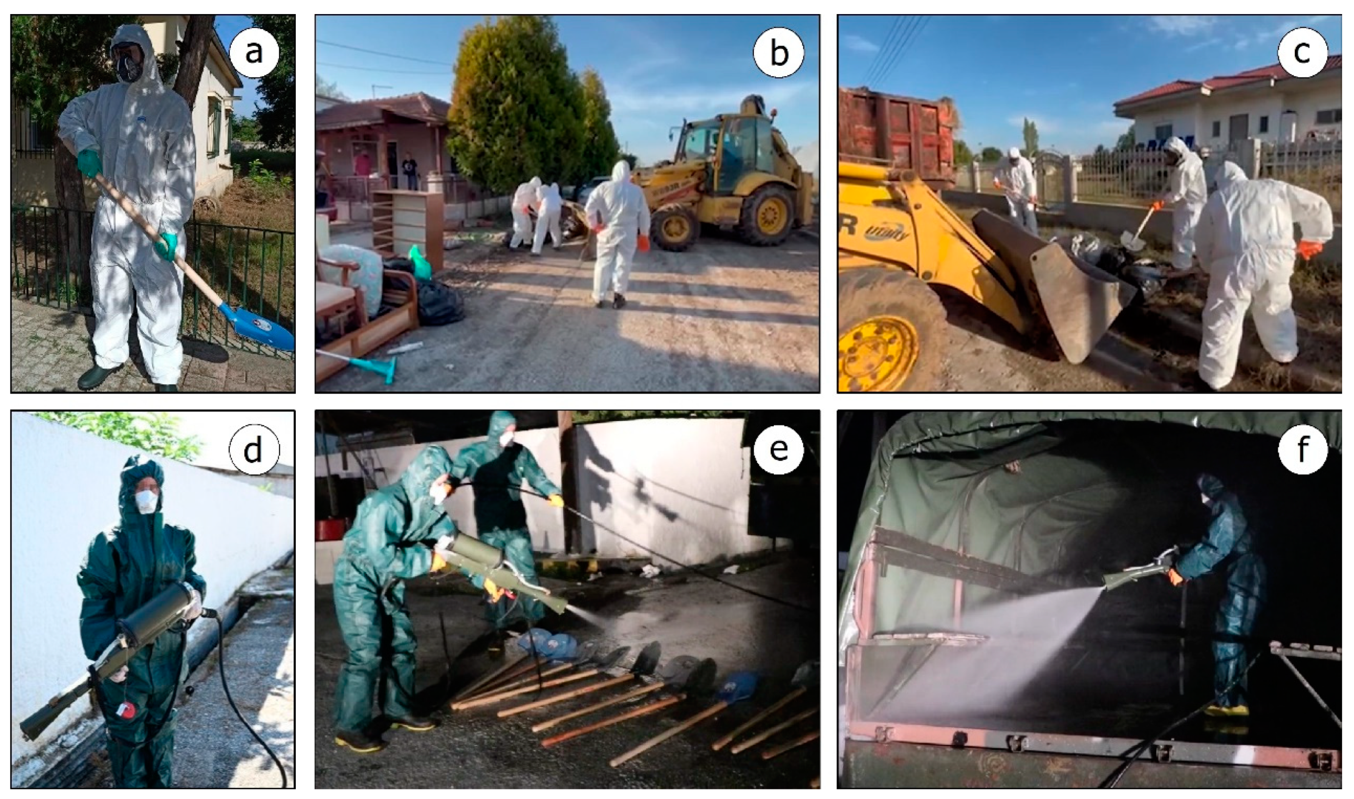
5.5. Public Health Risks Associated with Flood Waste

Flooding can affect buildings in urban and rural areas, resulting in considerable impact on their structural and non-structural elements and their equipment. Water flow can carry all of the above away and the flooding of areas for long periods of time can totally destroy them. These effects depend on the building construction type and the level that the flood water will eventually reach. With regard to the building construction type and the severity of the flooding effects on buildings in the Thessalian Plain, it was recorded that many of the buildings with load-bearing masonry walls were found covered by floodwater for many days. In many cases, the water reached either up to the roof of the ground floor or up to the middle of the first floor [7]. The result of these extreme hydrometeorological events was the partial or total collapse of many buildings with load-bearing masonry walls (Figure 5a–c). These collapses are mainly attributed to the presence of clay in the structural elements of the buildings and the lithology in the foundation and the surrounding area. The burden on these structures caused by recent destructive events in the area, such as the Mw = 6.3 and Mw = 6.1 Thessaly earthquakes generated on 3 and 4 March 2021, respectively, is also significant [15].
In the Thessalian Plain, not only agricultural land but also 21 villages were flooded. The flood water level either reached the roof of the ground floor or covered them completely. As a result, the household equipment of the houses and the professional equipment of the farms were completely destroyed. After the water receded, the residents who returned back home started repairing their premises. Τhe owners emptied their houses of the destroyed equipment and the debris was placed on the street for the crews to pick up (Figure 5d–f). In many of the flooded villages, however, piles of flood debris were created [7], which even today, months after the water receded, have not been removed from the villages, posing safety and public health risks.
According to the main body of waste management in the four affected regional units of Thessaly (Larissa, Magnesia, Karditsa, and Trikala), tens of thousands of tons of flood waste were created from the cleaning of buildings. Their final disposal was planned to take place in landfills [66] without any prior treatment for the separation of hazardous materials and recycling. This approach poses many risks to public health and the environment, from the early collection to the final disposal. These risks are mainly attributed to the flood waste presented in Table 1, which can be divided into several materials, including hazardous ones, among others.
The processes that favor the emergence of diseases due to exposure to flood waste are as follows:
  • The production of asbestos-containing dust during the various phases of waste management;
  • The presence of fecally contaminated materials in the waste;
  • The creation of injuries and wounds during the management of flood waste;
  • The presence of spoiled food as a bacteria breeding ground;
  • The presence of food exposed to humidity and inadequate ventilation conditions leading to the growth of mold on food;
  • The discharge of treated wood into the environment without prior treatment;
  • The burning of treated wood with CCA;
  • The leaching of chemicals and heavy metals from wood during flood waste disposal;
  • The influx of heavy metals and other chemicals into surrounding surface water bodies;
  • The discharge of waste into surrounding surface water bodies;
  • The selection of unsuitable sites for waste disposal, especially close to residential areas, areas of ecological value, and sensitive natural landscapes;
  • The application of inappropriate treatment and disposal methods.
All residents, workers, and volunteers who have been exposed to damaged asbestos-containing materials have a significant risk of developing upper respiratory tract irritation as well as severe pulmonary diseases including asbestosis and mesothelioma [68,69]. Foodborne diseases can also result from handling and consuming perishable goods contaminated with the bacteria of the family Enterobacteriaceae such as Escherichia coli and Salmonella spp. [68,69]. In addition, food left exposed to moisture and inadequate ventilation can create conditions conducive to mold growth and the formation of mold derivatives that can lead to allergies and other respiratory issues. The exposure of people involved in the disposal of treated wood of decaying materials may cause skin rashes and irritation of the respiratory tract [68,69]. There is an increased risk of injuries during the evacuation and removal of debris, e.g., skin punctures, cuts, and abrasions. Any skin discontinuity facilitates the penetration of bacteria into the human body and contributes to the development of tetanus [68,69].

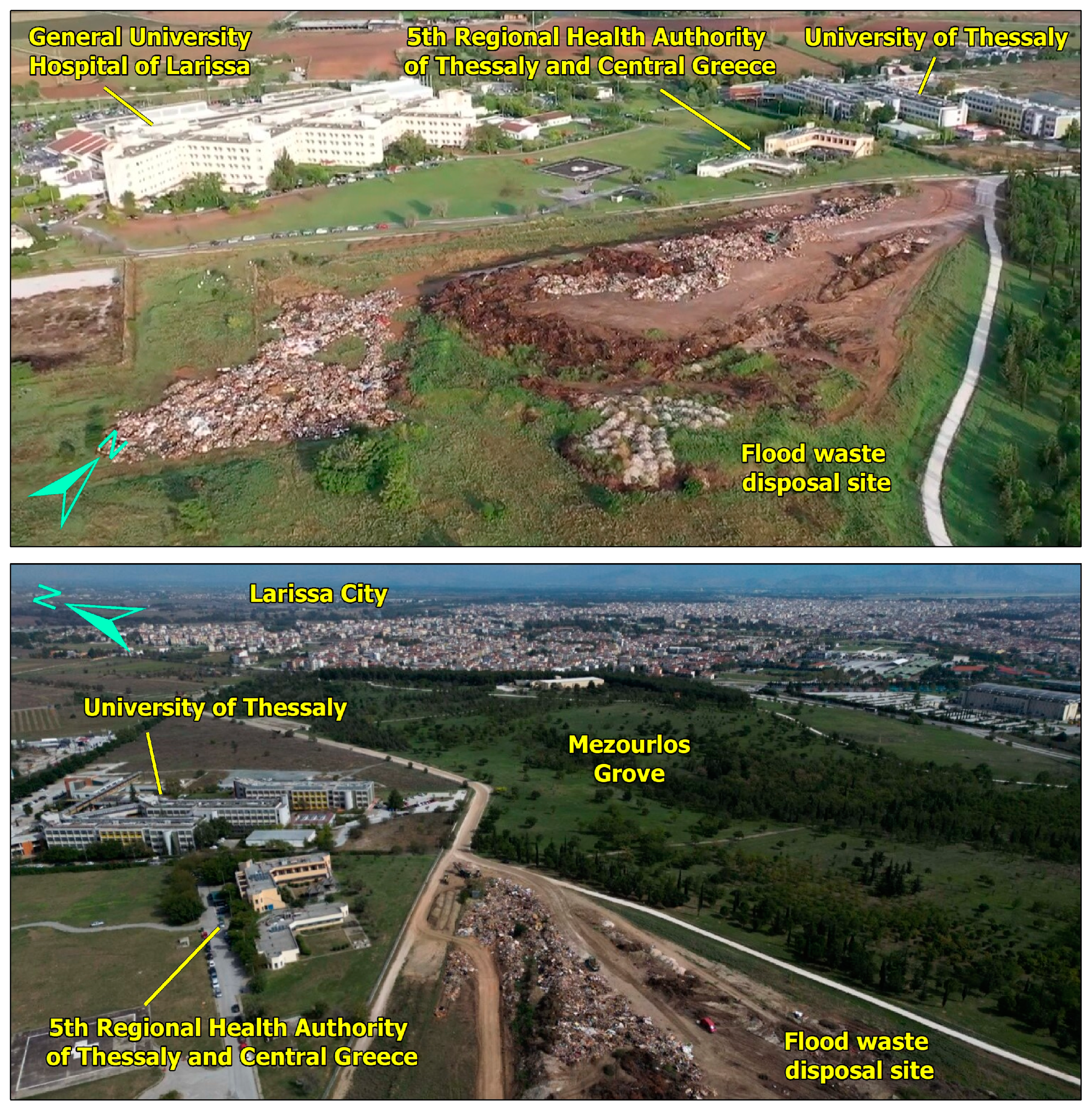
5.6. Public Health Risks Associated with Flood Waste Disposal Sites

In addition to the risks related to the hazardous elements that may be contained in flood waste, another risk to public health arises from the wrong selection of disposal sites. The unsuitability of these sites is mainly related to and attributed to their proximity to residential areas where people live and work, as well as their proximity to vulnerable ecosystems such as surface and groundwater bodies including rivers, streams, lakes, seas and aquifers, forests and crops, and coastal and lakeside areas among others [68,69]. The disposal of flood waste in such sites without prior sorting and treatment can affect public health either directly, through human contact with the harmful waste mentioned earlier, or indirectly through the disturbance of the natural environment [68,69].
In the case of the flooded Thessalian Plain, flood waste disposal sites were found in locations that had the above negative characteristics and were characterized as unsuitable for such use. They had been created in close proximity to residential areas including not only villages but also cities in the affected area.
In terms of proximity to residential areas and critical infrastructure, the landfill of the Mezourlos area is the most typical example of a site on the outskirts of the city of Larissa (Figure 6). It was created in an area that was located close to (i) critical facilities, such as the General University Hospital of Larissa and the 5th Regional Health Authority of Thessaly and Central Greece; (ii) educational infrastructure, such as the University of Thessaly; and (iii) sensitive ecosystems, such as the Mezourlos Grove (Figure 6). In this site, flood waste such as furniture, household goods, and other bulky items from flooded houses and businesses were disposed of. The crushing of the waste was also reported, which further aggravated the situation not only at this site, but also in the surrounding area due to the dust clouds generated during processing and possible air pollution. Fortunately, further disposal was stopped at this site after the reopening of the Larissa landfill site, to which the flood waste from the Mezourlos site was also transferred. However, the same did not happen at all the aforementioned flood waste disposal sites.
In addition, the disposal sites close to the affected settlements were operated next to the road (Figure 7a,b) in large piles with various types of flood waste without sorting (Figure 7c,d). This enabled the immediate and easy disposal of waste even by residents. As a result, these disposal sites were able to receive waste even 5 months after flooding had occurred without any restriction from the competent authorities or prior sorting of the waste. This proximity enabled many residents, coming from different cultural backgrounds and with limited family income, to search the sites for objects that could be repaired, reused, and recycled (Figure 7e,f), unaware of the risks that this activity poses first to their health and then to public health.

5.7. Impact of Flood-Damaged Housing on the Health of Residents and Environmental Risk Factors

Public health concerns can emerge from indoor dampness, pests, and mold growth. In several severely flooded areas in Japan between 2004 and 2010, Azuma et al. [70] studied the effects of water-damaged houses on public health. Comparing water-damaged to undamaged houses in the same regions, they discovered that there was a considerable increase in interior humidity and visible mold growth in the damaged houses. These problems gradually decreased a week after the flood, but they persisted for six months and were increased in houses with elevated flood levels.
Riggs et al. [71] found that flooding following the Hurricanes Katrina and Rita in New Orleans, USA, created conditions ideal for the growth of mold in house interiors, which reached high levels in the following months. Higher levels of mold growth were observed in houses with larger flood damage, particularly those with >90 cm indoor water level, compared to houses with little or no flood damage [71,72]. In houses that suffered moderate and severe damage following the Hurricanes Katrina and Rita, molds, endotoxins, and fungal glucans were detected indoors at concentrations that have been associated with adverse health effects [73,74]. High fungal levels in houses after flooding were also observed in southern Taiwan after typhoon Morakot but were lower than those observed in water-damaged homes in New Orleans, Louisiana after the Hurricanes Katrina and Rita [75].
Exposure to moisture and mold is associated with adverse effects on respiratory system health [76]. Azuma et al. [70] demonstrated that in the week following the flood, the number of respiratory, cutaneous, ocular, and nasal complaints in the water-damaged residences was much greater than in the unaffected ones. Therefore, the impact of flooding on public health was more evident in the initial stage after flooding. A further compelling correlation was discovered between the nasal and respiratory symptoms and exposure to water damage even six months following the Hurricanes Katrina and Rita [76,77].
During the Iowa flood of June 2008, the Cedar River reached its highest level in the history of the city of Cedar Rapids (Iowa, USA). More than 10 square miles of the city were submerged under the floodwater. This massive flood impacted 5390 residences, displaced more than 18,000 individuals, and caused damage to more than 310 city facilities. Hoppe et al. [78] indicated that the residences undergoing renovations exhibited much greater airborne quantities of mold, bacteria, endotoxin, glucans, and inhalable particulate matter than the completed ones. The occupants of the residences undergoing renovations reported a considerably greater incidence of allergic symptoms. Compared to the pre-flood period, there was a higher incidence of wheezing and prescription drug use for breathing problems following the 2008 Iowa flood [78].
The massive flooding of more than 120,000 houses after the Hurricane Katrina also created respiratory problems for people who decided to return back home. As the toxic water slowly receded through the processes of evaporation and repeated pumping, there was a release of fungal spores (mold) and endotoxins into the atmosphere both inside and outside the houses [74].
Long-term exposure to elevated levels of mold causes respiratory inflammation and allergic reactions in humans [79]. In particular, exposure to airborne endotoxins causes coughing, flu symptoms, headaches, chronic bronchitis, and many other serious respiratory diseases [73,80].
High concentrations of spores are also released as demolition or rehabilitation processes continue, so exposure to mold and endotoxins continues to pose a significant threat to the respiratory health of hundreds of thousands of people returning home [81].
In the Thessalian Plain, many settlements were inundated by flood water for a long period of time until the phenomena subsided. Water affected walls, floors, furniture, carpets, and other porous materials. Numerous building materials containing organic compounds, such as wood, plasterboard, and insulation, provided a breeding ground for the further growth of mold spores.
These spores also have the ability to spread to larger surfaces with high levels of humidity and organic material, and move through the air to other locations of the house where they grow when conditions become favorable again. In many structures (e.g., houses and schools) in both the urban and rural areas of Thessaly mold posed health risks, such as allergic reactions and respiratory problems, for residents, students, and other population groups in the flood-affected area. In fact, the mold impact on the health of those affected by the storm Daniel could be more pronounced as the post-disaster phase began in early October, with weather conditions (e.g., temperature and humidity) reducing evaporation from the structures’ interior and allowing mold to remain active and grow further.
The most typical examples of municipalities which were inundated by flood water and face public health risks from mold are Palamas Municipality with the Metamorphosis, Vlochos, Palamas, and Koskinas villages and Farkadona Municipality with the Farkadona, Georganades, and Keramidi villages. It should be noted that in many cases, residents returned to their flood-affected houses even 5 months after the destructive events.

5.8. Disease Exacerbation Related to Infrastructure Failure

The extreme weather event and the subsequent floods had a destructive impact on the networks and infrastructure of the Region of Thessaly. Roads were inundated by flooding or destroyed by landslides triggered by rainfall and erosion and bridges were destroyed by the abrupt flood water flow resulting in transport and traffic disruption and the temporary blockage of villages with populations of hundreds of residents (Figure 8) [7].
The electricity supply network was severely affected with many of its components, such as power poles and power cables, being damaged not only by the rushing flood water but also by severe erosion and landslides triggered in parts of the flooded areas [7]. Power outages affected communication, drinking water supply, and the preservation of perishable goods including food and medicines in the affected households.
Health care and treatment are frequently jeopardized when the infrastructure supporting public health services is destroyed, rendered inoperable, or otherwise damaged, which can exacerbate disease or even result in fatalities. The most vulnerable individuals with non-communicable diseases are those receiving treatment for cancer and those with uncontrolled diabetes, renal disease, and underlying respiratory and cardiovascular diseases [82].
All these disasters minimize the affected community’s ability to recover, particularly in the first hours, days, and months after the disaster. The recorded damage to networks and infrastructure contributes to inappropriate and inadequate sanitation, feeding, and health care conditions in areas affected not only by hydrometeorological hazards including floods [2], but also by geophysical hazards including earthquakes [57,83] and their accompanying or triggered phenomena.

6. Measures for the Safety and the Protection of Public Health from Floods in Thessaly

Measures to limit the impact of the flooding phenomena of the Thessalian Plain on public health were announced by the Ministry of Health and the NPHO after the generation of the extreme weather events and the subsequent flooding [62,63,84,85,86,87,88,89,90].
The Ministry of Health established the Public Health Coordination Centre (PHCC) in Larissa, which is the capital city of the Region of Thessaly, and presented the operational planning for the prevention and response to public health risks. The PHCC met on a daily basis with the participation of all the Civil Protection and Public Health agencies in order to make an immediate assessment of the situation, per affected area, and to take the necessary and effective protection measures based on its characteristics and needs. These measures included instructions mainly to the local population and its vulnerable groups (e.g.,children and elderly), health professionals, and the staff active in the disaster field for emergency response and recovery actions (e.g., firefighters, rescuers, and volunteers).
The Ministry of Health announced guidelines for protection after a flood, which were the following [62,63,84,85,86,87,88,89]:
  • The information and early warning of the public by the competent services of the Regional and Local Authorities, which included instructions for the following: (i) the movement of residents in flooded areas; (ii) the consumption of food and water; (iii) the prevention of diseases; (iv) the protection of domestic or farmed animals; (v) the safety of children in flood-affected areas; (vi) the cleaning of flood-affected houses, including general cleaning instructions, instructions for dehumidification and mold removal, as well as protection from asbestos-containing materials during the cleaning and/or repair of damage to houses.
  • Informing health professionals on the early detection, recording, and reporting of food- and water-borne diseases and zoonoses to protect the population and public health in flood-affected areas.
  • Carrying out immediate sanitary inspections of water supply systems in the event of detected damage.
  • The correct and hygienic handling and preservation of food in the event of frequent and prolonged power outage.
  • Food safety at all the stages of the food production chain.
  • Safeguarding public health during the preparation and provision of meals, as well as during their provision in flood-affected areas.
  • Monitoring the water quality for human consumption in the affected areas of the Thessalian Plain by the responsible agencies and the competent authorities.
  • The protection of the firefighters.
  • Cleaning and disinfection outdoor areas in flood-affected cities, towns, and villages.
  • Carrying out emergency health inspections for the reopening of educational facilities (for day and night schools, public and private schools, public and private infant and nursery schools, private and public technical schools and universities).
For the safety and protection of public health, the NPHO, through its website [90], also announced instructions for the following:
  • Returning home after the flood, with emphasis on the first entry.
  • The safe cleaning of the house.
  • Hygiene and disease prevention.
  • The safe cleaning and disinfection of school buildings after the flood, with emphasis on the first entry.
  • Schools where the water is non-potable.
  • The prevention and treatment of infectious diseases associated with the flood, with emphasis on diarrhoeal diseases and trauma infections.
  • Rodent and vector management in the flood-affected areas of Thessaly, such as (i) the installation of mosquito (adult) mite traps, and collection and dispatching of mite samples; (ii) larval sampling;and (iii) the evaluation of entomological data and control actions such as the intensification of larvicides, and residual spraying of outdoor areas (acaricides) and insecticide with ultra low-volume sprays.
  • The prevention of food- and water-borne diseases in the case of the overcrowding of the flood-affected people in emergency shelters, such as (i) keeping cooked food separate; (ii) safe transporting and storing food; (iii) ensuring that the food is well cooked; (iv) keeping food at safe temperatures; (v) drinking safe water; and (vi) following hygiene rules.
In addition, the NPHO created information material (brochures and posters) to inform citizens and health professionals about leptospirosis, which was also posted on its website.
A typical example of the implementation of measures to prevent flood-related infectious diseases comprised the protective measures applied by the staff of the Hellenic Armed Forces during conducting emergency response actions in the Thessalian Plain. In particular, the Hellenic National Defense General Staff (HNDGS), in consultation with the competent Civil Protection and Public Health authorities, contributed to the collection of dead animals left behind by the storm Daniel and the subsequent floods [91,92]. Special teams were formed and carried the PPE against infectious biological agents (Figure 9) [91,92]. At the same time, stations were established by a special interdisciplinary nuclear–biological–chemical defense response team of the HNDGS to decontaminate vehicles, equipment, and clothing after the completion of field activities (Figure 9) [91,92].

7. Discussion

Considering the reviews by Mavrouli et al. [2,57] on infectious diseases associated with disasters from geophysical and hydrometeorological hazards, the factors that favor the emergence and incidence increase in post-disaster infectious diseases were present in the affected areas of the Thessalian Plain affected by the storm Daniel and subsequent flooding.
Taking into account the duration and evolution of the flooding phenomena, the extent of the flooded area, the type of affected land use in Thessaly, and the adverse conditions, the flooded Thessaly Plain could not be an exception in the increased incidence of leptospirosis during and after the completion of the phenomena. In fact, the incidence of leptospirosis cases was significantly higher (6.5/100,000) compared to the historical data of the last 10 years for Thessaly (average number of cases: 0.13/100,000) [43].
The flooding and the destruction of water supply and irrigation facilities in many areas of the Thessalian Plain led shortly after the storm to a lack of sufficient potable water and running water for the cleaning of the flooded houses and infrastructure. This resulted in a large percentage of the population using water from contaminated sources with all that this entails for public health, the delay in the recovery, and returning back home. Consuming contaminated water or food or coming into contact with contaminated surfaces can result in the occurrence of gastroenteritis. Clusters of gastroenteritis cases were recorded in the settlements of the flood-affected areas of the Thessalian Plain based on official announcements from the Hellenic Government [63].
The generation of a large volume of flood waste and its uncontrolled disposal in various sites with easy access close to residential areas and critical infrastructure is characterized by a high potential to impact the natural environment and public health. This could have been carried out in two ways: either directly through contact during the waste treatment and disposal processes without prior raising awareness and information of the inhabitants by the competent bodies about the relevant risks or indirectly through environmental pollution.
Receding water could provide an ideal mosquito breeding habitat and enhance the likelihood of exposing the flood-affected populations and emergency response staff to mosquito-borne pathogens that cause diseases such as West Nile fever, malaria, and dengue fever [93]. However, mosquito density may be negatively influenced since rainfall and subsequent flooding can provide abundant water that dilutes organic matter and washes out mosquito habitats [94]. This effect combined with the colder weather conditions and the implementation of preventive larviciding/adulticiding actions against Culex pipiens mosquitoes (major vectors of WNV in Greece) in the flood-affected area resulted in no cases of WNV infection being recorded from mid-October onwards.
A huge number of injuries during a disaster and the poor immunization status of the population due to limited tetanus vaccination coverage could lead to the occurrence of tetanus outbreaks. There is a plethora of actions in the disaster field, posing a risk of tetanus occurrence that took place in the Region of Thessaly during the emergency and recovery phases. The main and most important ones are remaining in floodwater during the rescue of trapped people from flooded areas, transporting basic essential items to areas isolated from the flood, managing flood debris from the early stages of removal to final disposal, and removing hazards both during the development of the event and in the post-disaster stage. The successful national vaccination program against tetanus and the timely and effective vaccination of the flood-affected individuals that were unvaccinated or had an unknown history of vaccination prevented the occurrence of tetanus sporadic cases or outbreaks following the storm Daniel and its subsequent flooding. Nevertheless, tetanus cases can be underreported or underestimated, particularly since the disease is becoming less common and partially immunized patients may present with very mild disease symptoms [95].
Additionally, floods can pose a major threat to public health, especially in areas where infectious disease transmission is already endemic [2]. An increased incidence of acute respiratory infections mainly due to the influenza virus and SARS-CoV-2 was recorded in the flood-affected Thessalian Plain. When both of these viruses, causing highly contagious respiratory infections, co-circulate in the general population, there is a high chance of overlapping epidemics, leading to an escalation of co-infections. Although co-infections do not occur frequently, they may pose health challenges for vulnerable population groups such as patients with chronic diseases and the elderly [96]. The health care system is already facing a significant burden due to the high prevalence of a single virus, let alone the potential burden from overlapping epidemics. Therefore, the best approaches to address this threat are the prevention of infection emergence, surveillance enhancement, and the promotion of vaccine uptake [96].
All of the aforementioned highlight the fact that a new approach for climate-resilient infrastructure is needed. This requires climate resilience to be taken into account at all stages of the infrastructure project lifecycle, including planning, design, construction, and maintenance [97].
The construction of climate-proof rural and urban infrastructure and advanced resilient infrastructure planning comprises several important actions, which can be classified into non-structural and structural measures [98]. The non-structural measures comprise mainly the following: (i) the vulnerability assessment of key and critical infrastructure and vulnerability reduction research; (ii) urban planning adapted to new conditions for mitigating impact from future extreme events; (iii) establishing, maintaining, and improving early warning systems for recording, forecasting, and monitoring extreme events in real-time and warning issuing; (iv) updating and improving building codes and all the relevant emergency response and management plans at all levels of governance for addressing the impacts of extreme events and climate change; (v) information and awareness raising activities for the population and training of all the stakeholders in disaster prevention and the management of natural hazards [7,99,100].
The structural measures generally include the construction of new infrastructure and interventions on the existing ones. The climate-resilient design and construction should be always adapted to the properties not only of the expected extreme events, but also of the areas that may be affected. These structural measures include, for example, the use of durable construction materials that can withstand extreme weather conditions, such as extreme temperatures, fires, heavy rainfall, and floods. Furthermore, they comprise the installation of energy-efficient technologies and renewable energy sources, the adoption of green infrastructure, and the implementation of flood protection works comprising levees, floodwalls, and barriers to protect infrastructure from flooding [7]. In several cases, aging infrastructure may need to be replaced or adapted to meet today’s needs. The existing assets may need to be retrofitted or operated differently to account for climate change impacts over the course of the asset’s life [97]. Ensuring climate-resilient infrastructure will contribute to the protection of lives and livelihoods, the reduction in human and economic losses, the development through investment by households and businesses, and the creation of positive economic, social, and environmental co-benefits [100].
Among the critical infrastructures and systems whose capacity and resilience to climate change must be considered and increased are the health care systems. They are burdened by the increase in the severity and frequency of extreme events, the disruption of food systems, the increase in infectious and non-communicable diseases, and the conflict risk associated with water scarcity, population movements, and economic factors that deepen health inequalities [101]. The smooth functioning of health systems is also affected by the structural and non-structural failures of their facilities and equipment, such as hospitals and health centers, medical devices and products, and water, waste, energy, and transport systems. All of these impacts have a direct or indirect impact on health workers, with the provision of health services also being affected [102,103].
In the frame of the recently formed conditions and emerged challenges during the evolving climate change, health systems need to be reshaped in a way that continues to provide safe and quality care to the population. Mosadeghrad et al. [104] reviewed the strategies to strengthen a climate-resilient health system based on a total of 105 studies conducted between 2005 and late June 2022. The most commonly reported actions in descending order of reference are (i) the development of a national health and climate change adaptation plan; (ii) the development of contingency plans and backup systems for essential services (electricity, heating, cooling, ventilation, and water supply); (iii) the assessment of the vulnerabilities, needs, and capacities of stakeholders and health systems; (iv) the enhancement of surveillance systems targeting climate-sensitive infectious diseases and their risk sources; (v) the research into climate change’s impact on health [104].
For the successful and effective outcome of all the above actions for the development of a climate-resilient health care system, the interconnections between human, animal, plant, and ecosystem health should be taken into account. In fact, a collaborative, multi-sectoral, and transdisciplinary One Health approach should be applied. The added value of the One Health approach to climate change adaptation is that it may significantly contribute to (i) food security and safety; (ii) extensive livestock systems; (iii) antimicrobial resistance control; (iv) integrated approaches to safe water, environmental sanitation, and hygiene; and (v) steps towards regional and global integrated human and animal surveillance and response systems [105].
Regarding the mobilization of the involved Civil Protection and Public Health authorities for dealing with the potential health impact of the floods in the Thessalian Plain, it is concluded that the implemented actions followed the international best practices and lessons learned from recent destructive events.
In Greece, due to its geotectonic location, the intense seismicity [106], and the strong and destructive earthquakes [13,14], earthquake safety forms an integral part of the infrastructure management and community culture. The response planning for the earthquake emergency in Greece [107], which is practiced by means of drills and exercises, is also tested under real conditions and at a large scale during recent earthquakes, including the 3 March 2021, Mw = 6.3 Thessaly earthquake, which affected a large part of the flooded northern Thessaly in early September 2023 [15].
The same approach is not applied in Greece for reducing flood risk. Although a master plan for the emergency response and management of the impact of flooding, titled “Dardanos” from Greek mythology, has been in place since 2019 [108] and updated in 2022 [109], actions to inform the population and exercises to better coordinate Civil Protection agencies in case of flooding have not been implemented so far. These information, education, and training actions are very important as they allow for a more effective management of the flood impact. This applies not only to the direct impacts of flooding on the population and the built environment, but also to the indirect impacts, such as the sporadic cases, outbreaks, and epidemics of infectious diseases in the flood-affected areas.
There is a need for flexible planning and measures with the ability for the quick and effective integration of unforeseen conditions and related adverse effects [110]. This approach requires the improvement of our knowledge of the relation between infectious diseases and disasters induced by hydrometeorological hazards. The measures for preventing infectious disease outbreaks and mitigating their effects on the affected population and the involved staff should be incorporated into the emergency response planning for disasters induced by natural hazards [111]. Furthermore, these measures should be timely and effectively communicated not only to the staff involved in the prevention and management of these emergencies, but also to the general public and, in particular, to vulnerable groups [111]. These groups comprise poor communities, newborns and children, women, ethnic minorities, migrants or displaced persons, older populations, indigenous people, and persons with pre-existing health conditions [101].
Particular attention should be paid when the hazards of the same or different type either co-exist or collide. If we consider the large number of synergies and interactions between natural hazards, as presented by Gill and Malamud [112,113], we can imagine how much these interactions can increase when an interplay of different types of hazards takes place and how complex the disasters can be. This complexity has already been clearly demonstrated during the years of the COVID-19 pandemic.The parallel evolution of geophysical hazards (earthquakes and their primary and secondary effects), hydrometeorological hazards (floods and cyclones), and biological hazards (infectious diseases and pandemic COVID-19) highlighted incompatibilities between the emergency response and recovery from the natural phenomena and the measures applied for reducing the spread of the novel virus in the community [11,15].
For the effective management of this complexity, as was the case in the Region of Thessaly, multi-hazard approaches are required, with emphasis on the potential complexity of phenomena and impacts [11,15]. The most important of them include enhanced post-disaster epidemiological surveillance systems, risk assessments, and specific prevention and control strategies depending on the characteristics and properties of all the generated and collided events and their impact [2,57].

8. Conclusions

The Region of Thessaly was affected in early September 2023 by the storm Daniel and subsequent floods that resulted in extensive and severe impacts on the built environment (buildings, networks, and infrastructure), the natural environment (water bodies and soil) and the population (fatalities, injured, homeless, and displaced people). In addition to the direct impact, conditions and factors favorable for the indirect public health impacts (infectious diseases) were also formed in the flood-affected areas. The factors had to do with water-, rodent- and vector-borne diseases, injuries, respiratory infections, water contamination, flood waste, and their disposal sites as well as structural damage to buildings and the failures of infrastructure. In order to diagnose, monitor, and control emerging infectious diseases as soon as possible, it is essential to establish robust disaster preparedness plans that include adequate environmental planning, resilient infrastructure, and health care facilities, as well as effective global and local disease surveillance systems.
The conditions that emerged resulted in the mobilization of the Civil Protection and Public Health authorities not only to deal with the impact of the storm and the subsequent flooding, but also to prevent and manage indirect public health impacts. The instructions and guidelines to affected residents, health professionals, and Civil Protection staff were in line with the international good practices and lessons learned from recent examples of complex and compound disasters around the world.
Emphasis should be placed on training actions for the Civil Protection and Public Health staff, but also on education, raising awareness, and the training of the population and, in particular, of vulnerable groups. More specifically, drills and exercises should be carried out for the staff of the Civil Protection and Public Health agencies to highlight the shortcomings of response and recovery plans, systems, and actions and to review preparedness, capacity, immediate response, and cooperation between the involved authorities. In these actions, it is important that citizens are actively involved in adopting a sound and effective response to complex emergencies.
Furthermore, non-structural and structural measures should be implemented for increasing the climate resilience of critical infrastructures including health care systems. National health and climate change adaptation plan should be updated and the contingency plans should be revised and improved based on the characteristics of the extreme events and the affected areas. The vulnerabilities, needs, and capacities of stakeholders and health systems should be assessed and the surveillance systems should be enhanced for addressing climate change’s impact on public health. All these actions should be implemented in the frame of an interdisciplinary and multiparametric One Health approach, which takes into account the interconnections between human, animal, plant, and ecosystem health.

Author Contributions

Conceptualization, S.M. and M.M.; methodology, S.M., M.M. and E.L.; validation, S.M. and M.M.; formal analysis, S.M. and M.M.; investigation, S.M. and M.M.; resources, E.L.; data curation, S.M. and M.M.; writing—original draft preparation, S.M. and M.M.; writing—review and editing, S.M., M.M., E.L. and A.T.; visualization, S.M.; supervision, S.M.; project administration, S.M. and M.M.; funding acquisition, E.L. All authors have read and agreed to the published version of the manuscript.

Funding

This research received no external funding.

Data Availability Statement

The original contributions presented in the study are included in the article, further inquiries can be directed to the corresponding author.

Acknowledgments

Three anonymous reviewers are acknowledged for their constructive comments that helped improve the clarity, scientific soundness, and overall merit of this work.

Conflicts of Interest

The authors declare no conflicts of interest.

References

  1. McBean, G. Hydrometeorological Hazards. In Encyclopedia of Earth Sciences Series; Bobrowsky, P.T., Ed.; Springer: Dordrecht, The Netherlands, 2003. [Google Scholar] [CrossRef]
  2. Mavrouli, M.; Mavroulis, S.; Lekkas, E.; Tsakris, A. Potential infectious diseases following floods induced by extreme precipitation events. In Proceedings of the 27th European Congress of Clinical Microbiology and Infectious Diseases, Vienna, Austria, 22–25 April 2017; p. 3545. [Google Scholar]
  3. Centre for Research on the Epidemiology of Disasters (CRED). EM-DAT—The International Disaster Database. Available online: https://public.emdat.be/ (accessed on 25 February 2023).
  4. Lekkas, E.; Nastos, P.; Cartalis, C.; Diakakis, M.; Gogou, M.; Mavroulis, S.; Spyrou, N.-I.; Kotsi, E.; Vassilakis, E.; Katsetsiadou, K.-N.; et al. Impact of Medicane “IANOS” (September 2020). Newsletter of Environmental, Disaster and Crises Management Strategies. 2020. Available online: https://edcm.edu.gr/images/docs/newsletters/Newsletter_20_2020_Ianos.pdf (accessed on 25 February 2024).
  5. Diakakis, M.; Mavroulis, S.; Filis, C.; Lozios, S.; Vassilakis, E.; Naoum, G.; Soukis, K.; Konsolaki, A.; Kotsi, E.; Theodorakatou, D.; et al. Impacts of Medicanes on Geomorphology and Infrastructure in the Eastern Mediterranean, the Case of Medicane Ianos and the Ionian Islands in Western Greece. Water 2023, 15, 1026. [Google Scholar] [CrossRef]
  6. Mavroulis, S.; Mavrouli, M.; Lekkas, E. Geological and hydrometeorological hazards and related disasters amid COVID-19 pandemic in Greece: Post-disaster trends and factors affecting the COVID-19 evolution in affected areas. Saf. Sci. 2021, 138, 105236. [Google Scholar] [CrossRef]
  7. Lekkas, E.; Diakakis, M.; Mavroulis, S.; Filis, C.; Bantekas, Y.; Gogou, M.; Katsetsiadou, K.-N.; Mavrouli, M.; Giannopoulos, V.; Sarantopoulou, A.; et al. The Early September 2023 Daniel Storm in Thessaly Region (Central Greece). Newsletter of Environmental, Disaster and Crises Management Strategies. 2024. Available online: https://edcm.edu.gr/images/docs/newsletters/Newsletter_30_2024_Daniel_Thessaly.pdf (accessed on 25 February 2024).
  8. Mavrouli, M.; Mavroulis, S.; Lekkas, E.; Tsakris, A. Infectious Diseases Associated with Hydrometeorological Hazards in Europe: Disaster Risk Reduction in the Context of the Climate Crisis and the Ongoing COVID-19 Pandemic. Int. J. Environ. Res. Public Health 2022, 19, 10206. [Google Scholar] [CrossRef]
  9. Mavroulis, S.; Mavrouli, M.; Lekkas, E.; Tsakris, A. Impact of floods induced by extreme precipitation events on public health. Geophys. Res. Abstr. 2017, 19, EGU2017-3886. [Google Scholar]
  10. Copernicus EMS Rapid Mapping. EMSR692—Flood in Greece. 2023. Available online: https://rapidmapping.emergency.copernicus.eu/EMSR692/download (accessed on 1 June 2024).
  11. Mavroulis, S.; Mavrouli, M.; Kourou, A.; Thoma, T.; Lekkas, E. Multi-Hazard Emergency Response for Geological Hazards Amid the Evolving COVID-19 Pandemic: Good Practices and Lessons Learned from Earthquake Disaster Management in Greece. Sustainability 2022, 14, 8486. [Google Scholar] [CrossRef]
  12. Spyropoulos, P. Chronicle of the Earthquakes of Greece, from Antiquity to Present; Dodoni Publications: Athens, Greece, 1997; 456p. [Google Scholar]
  13. Papazachos, B.; Papazachou, K. The Earthquakes of Greece; Ziti Publications: Thessaloniki, Greece, 2003; 286p. [Google Scholar]
  14. Ambraseys, N. Earthquakes in the Mediterranean and Middle East, a Multidisciplinary Study of Seismicity up to 1900; Cambridge University Press: Cambridge, UK, 2009; p. 970. [Google Scholar] [CrossRef]
  15. Mavroulis, S.; Mavrouli, M.; Carydis, P.; Agorastos, K.; Lekkas, E. The March 2021 Thessaly earthquakes and their impact through the prism of a multi-hazard approach in disaster management. Bull. Geol. Soc. Greece 2021, 58, 1–36. [Google Scholar] [CrossRef]
  16. Lekkas, E.; Hadjinakos, I.; Vassiliou, I. The landslide phenomena of Eastern Thessaly (Recording, Classification, Causes, Effects, Mitigation). In Proceedings of the 1st Scientific Conference “Geosciences and Environment”, Patras, Greece, 15–18 April 1991. [Google Scholar]
  17. Valkaniotis, S.; Papathanassiou, G.; Marinos, V.; Saroglou, C.; Zekkos, D.; Kallimogiannis, V.; Karantanellis, E.; Farmakis, I.; Zalachoris, G.; Manousakis, J.; et al. Landslides Triggered by Medicane Ianos in Greece, September 2020: Rapid Satellite Mapping and Field Survey. Appl. Sci. 2022, 12, 12443. [Google Scholar] [CrossRef]
  18. Mariolakos, I.; Fountoulis, I.; Spyridonos, E.; Bantekas, I.; Mariolakos, D.; Andreadakis, E. The geometry of the underground aquifer at Mount Narthakio (Thessaly) as a result of neotectonic deformation. In Proceedings of the 8th Panhellenic Conference of the Hellenic Hydrotechnical Association, Athens, Greece, 2–3 April 2000. [Google Scholar]
  19. Mariolakos, I.; Lekkas, S.; Papadopoulos, T.; Alexopoulos, A.; Fountoulis, I.; Alexopoulos, I.; Spyridonos, E.; Bantekas, I.; Mariolakos, D.; Andreadakis, E. The subsurface tectonic structure of the Farsala basin (Thessaly) as determining factor of the hydrogeological conditions of the region. Bull. Geol. Soc. Greece 2001, 34, 1851–1858. [Google Scholar]
  20. Special Secretariat for Water. 1st Revision of the River Basin Management Plan for the Water Basins of the Water Region of Thessaly (EL08); Interim Phase: 1, Deliverable: 1 Definition and Registration of Competent Authorities and Identification of the Area of Exercise of their Responsibilities; Ministry of Environment and Energy: Athens, Greece, 2017; 31p. [Google Scholar]
  21. Diakakis, M.; Mavroulis, S.; Deligiannakis, G. Floods in Greece, a statistical and spatial approach. Nat. Hazards 2012, 62, 485–500. [Google Scholar] [CrossRef]
  22. Panos, V. The River of Rage—1907 The Flood of Lithaios; Agapo tin Polin Publications: Athens, Greece, 2008; 144p, ISBN 9789608879768. [Google Scholar]
  23. Bantekas, I.; Diakakis, M.; Mavroulis, S.; Lekkas, E. Lithaios River. The great flood of 1907. One of the greatest natural disasters that hit Greece. In Proceedings of the International Conference “Pineios River: Source of Life and Development in Thessaly”, Larissa, Greece, 2–3 November 2018. [Google Scholar]
  24. Mimikou, M.; Koutsoyiannis, D. Extreme floods in Greece: The case of 1994. In Proceedings of the U.S.–ITALY Research Workshop on the Hydrometeorology, Impacts and Management of Extreme Floods, Perugia, Italy, 13–17 November 1995. [Google Scholar]
  25. Papavassileiou, G.; Dafis, S.; Kyros, C.; Lagouvardos, K. To What the Extreme Rainfall of Severe Weather Danielle Is Due. National Observatory of Athens. Available online: https://www.meteo.gr/article_view.cfm?entryID=2931 (accessed on 13 September 2023).
  26. Dimitriou, E.; Efstratiadis, A.; Zotou, I.; Papadopoulos, A.; Iliopoulou, T.; Sakki, G.-K.; Mazi, K.; Rozos, E.; Koukouvinos, A.; Koussis, A.D.; et al. Post-Analysis of Daniel Extreme Flood Event in Thessaly, Central Greece: Practical Lessons and the Value of State-of-the-Art Water-Monitoring Networks. Water 2024, 16, 980. [Google Scholar] [CrossRef]
  27. Vougioukas, S.; Koletsis, I.; Lagouvardos, K. Rainfall Heights of the Storm DANIEL in Thessaly. National Observatory of Athens. Available online: https://meteo.gr/article_view.cfm?entryID=2930 (accessed on 12 September 2023).
  28. Vougioukas, S.; Koletsis, I.; Lagouvardos, K. Assessment of the Storm DANIEL, Part 1: It Far Exceeded the Precipitation Heights of the 2020 Mediterranean Cyclone IANOS. National Observatory of Athens. Available online: https://w1.meteo.gr/article_view.cfm?entryID=2923 (accessed on 9 September 2023).
  29. Vougioukas, S.; Koletsis, I.; Lagouvardos, K. Assessment of the Storm DANIEL, Part 2: Much Higher Precipitation Heights in Thessaly Compared to the 2020 Mediterranean Cyclone Janus. National Observatory of Athens. Available online: https://meteo.gr/article_view.cfm?entryID=2924 (accessed on 9 September 2023).
  30. Zhang, L.; Yu, J.; Pan, H.; Hu, P.; Hao, Y.; Cai, W.; Zhu, H.; Yu, A.D.; Xie, X.; Ma, D.; et al. Small molecule regulators of autophagy identified by an image-based high-throughput screen. Proc. Natl. Acad. Sci. USA 2007, 104, 19023–19028. [Google Scholar] [CrossRef]
  31. Sarkar, A. Participatory Governance and inter-Sector Coordination for Sustainable Solutions of Arsenic Contamination of Groundwater in India: An Explorative Study. In Proceedings of the Amsterdam Conference on the Human Dimensions of Global Environmental Change—Earth System Governance: Theories and Strategies for Sustainability, Amsterdam, The Netherlands, 24–26 May 2007. [Google Scholar]
  32. Rael, R.C.; Peterson, A.C.; Ghersi, B.M.; Childs, J.; Blum, M.J. Disturbance, reassembly, and disease risk in socioecological systems. EcoHealth 2016, 13, 450–455. [Google Scholar] [CrossRef] [PubMed]
  33. Lewis, J.A.; Zipperer, W.C.; Ernstson, H.; Bernik, B.; Hazen, R.; Elmqvist, T.; Blum, M.J. Socioecological disparities in New Orleans following Hurricane Katrina. Ecosphere 2017, 8, e01922. [Google Scholar] [CrossRef]
  34. Peterson, A.C.; Ghersi, B.M.; Campanell, R.; Riegel, C.; Lewis, J.A.; Blum, M.J. Rodent assemblage structure reflects socioecological mosaics of counter-urbanization across post-Hurricane Katrina New Orleans. Landsc. Urban Plan. 2020, 195, 103710. [Google Scholar] [CrossRef]
  35. Haake, D.A.; Levett, P.N. Leptospirosis in humans. Curr. Top. Microbiol. Immunol. 2015, 387, 65–97. [Google Scholar] [CrossRef] [PubMed]
  36. Naing, C.; Reid, S.A.; Aye, S.N.; Htet, N.H.; Ambu, S. Risk factors for human leptospirosis following flooding: A meta-analysis of observational studies. PLoS ONE 2019, 14, e0217643. [Google Scholar] [CrossRef] [PubMed]
  37. Auld, H.E.; MacIver, D.; Klassen, J. Heavy rainfall and waterborne disease outbreaks: The Walkerton example. J. Toxicol. Environ. Health A 2004, 67, 1879–1887. [Google Scholar] [CrossRef] [PubMed]
  38. Gaynor, K.; Katz, A.R.; Park, S.Y.; Nakata, M.; Clark, T.A.; Effler, P.V. Leptospirosis on Oahu: An outbreak associated with flooding of a university campus. Am. J. Trop. Med. Hyg. 2007, 76, 882–885. [Google Scholar] [CrossRef]
  39. Chiu, C.-H.; Wang, Y.-C.; Yang, Y.-S.; Chang, F.-Y. Leptospirosis after Typhoon in Taiwan. J. Med. Sci. 2009, 29, 131–134. [Google Scholar]
  40. Su, H.P.; Chan, T.C.; Chang, C.C. Typhoon-related leptospirosis and melioidosis, Taiwan, 2009. Emerg. Infect. Dis. 2011, 17, 1322–1324. [Google Scholar] [CrossRef]
  41. Smith, J.K.G.; Young, M.M.; Wilson, K.L.; Craig, S.B. Leptospirosis following a major flood in Central Queensland, Australia. Epidemiol. Infect. 2013, 141, 585–590. [Google Scholar] [CrossRef] [PubMed]
  42. Dechet, A.M.; Parsons, M.; Rambaran, M.; Mohamed-Rambaran, P.; Florendo-Cumbermack, A.; Persaud, S.; Baboolal, S.; Ari, M.D.; Shadomy, S.V.; Zaki, S.R.; et al. Leptospirosis outbreak following severe flooding: A rapid assessment and mass prophylaxis campaign; Guyana, January–February 2005. PLoS ONE 2012, 7, e39672. [Google Scholar] [CrossRef] [PubMed]
  43. National Public Health Organization. NPHO Newsletter—May 2024. Leptospirosis and Climate Change: The Case of Thessaly. Available online: https://eody.gov.gr/enimerotiko-deltio-eody-maios-2024/ (accessed on 5 June 2024).
  44. Atil, A.; Jeffree, M.S.; Syed Abdul Rahim, S.S.; Hassan, M.R.; Lukman, K.A.; Ahmed, K. Occupational Determinants of Leptospirosis among Urban Service Workers. Int. J. Environ. Res. Public Health 2020, 17, 427. [Google Scholar] [CrossRef] [PubMed]
  45. World Health Organization (WHO). Vector-Borne Diseases. Available online: https://www.who.int/news-room/fact-sheets/detail/vector-borne-diseases (accessed on 5 June 2024).
  46. Takeda, T.; Whitehouse, C.A.; Brewer, M.; Gettman, A.D.; Mather, T.N. Arbovirus surveillance in Rhode Island: Assessing potential ecologic and climatic correlates. J. Am. Mosq. Control. Assoc. 2003, 19, 179–189. [Google Scholar] [PubMed]
  47. Soverow, J.E.; Wellenius, G.A.; Fisman, D.N.; Mittleman, M.A. Infectious disease in a warming world: How weather influenced West Nile Virus in the United States (2001–2005). Environ. Health Perspect. 2009, 117, 1049–1052. [Google Scholar] [CrossRef] [PubMed]
  48. Paz, S.; Malkinson, D.; Green, M.S.; Tsioni, G.; Papa, A.; Danis, K.; Sirbu, A.; Ceianu, C.; Katalin, K.; Ferenczi, E.; et al. Permissive summer temperatures of the 2010 European West Nile Fever upsurge. PLoS ONE 2013, 8, e56398. [Google Scholar] [CrossRef] [PubMed]
  49. Han, L.L.; Popovici, F.; Alexander, J.P., Jr.; Laurentia, V.; Tengelsen, L.A.; Cernescu, C.; Gary, H.E., Jr.; Ion-Nedelcu, N.; Campbell, G.L.; Tsai, T.F. Risk factors for West Nile virus infection and meningoencephalitis, Romania, 1996. J. Infect. Dis. 1999, 179, 230–233. [Google Scholar] [CrossRef] [PubMed]
  50. Hubálek, Z.; Savage, H.M.; Halouzka, J.; Juricová, Z.; Sanogo, Y.O.; Lusk, S. West Nile virus investigations in South Moravia, Czechland. Viral Immunol. 2000, 13, 427–433. [Google Scholar] [CrossRef] [PubMed]
  51. Hubálek, Z.; Zeman, P.; Halouzka, J.; Juricová, Z.; Stovicková, E.; Bálková, H.; Sikutová, S.; Rudolf, I. Mosquitoborne viruses, Czech Republic, 2002. Emerg. Infect. Dis. 2005, 11, 116–118. [Google Scholar] [CrossRef]
  52. Danis, K.; Papa, A.; Theocharopoulos, G.; Dougas, G.; Athanasiou, M.; Detsis, M.; Baka, A.; Lytras, T.; Mellou, K.; Bonovas, S.; et al. Outbreak of West Nile virus infection in Greece, 2010. Emerg. Infect. Dis. 2011, 17, 1868–1872. [Google Scholar] [CrossRef]
  53. Roiz, D.; Boussès, P.; Simard, F.; Paupy, C.; Fontenille, D. Autochthonous Chikungunya Transmission and Extreme Climate Events in Southern France. PLoS Negl. Trop. Dis. 2015, 9, e0003854. [Google Scholar] [CrossRef] [PubMed]
  54. Moirano, G.; Gasparrini, A.; Acquaotta, F.; Fratianni, S.; Merletti, F.; Maule, M.; Richiardi, L. West Nile Virus infection in Northern Italy: Case-crossover study on the short-term effect of climatic parameters. Environ. Res. 2018, 167, 544–549. [Google Scholar] [CrossRef] [PubMed]
  55. National Public Health Organization. Epidemiological Surveillance Reports of West Nile Virus Infection. Department of Vector-borne Diseases, Directorate of Epidemiological Surveillance and Intervention for Infectious Diseases, 22 EODY, Athens, Greece. Available online: https://eody.gov.gr/epidimiologika-statistika-dedomena/evdomadiaies-ektheseis/evdomadiaies-ektheseis-ios-dytikoy-neiloy/ (accessed on 5 June 2024).
  56. World Health Organization (WHO). Tetanus. Available online: https://www.who.int/news-room/fact-sheets/detail/tetanus (accessed on 20 March 2024).
  57. Mavrouli, M.; Mavroulis, S.; Lekkas, E.; Tsakris, A. The Impact of Earthquakes on Public Health: A Narrative Review of Infectious Diseases in the Post-Disaster Period Aiming to Disaster Risk Reduction. Microorganisms 2023, 11, 419. [Google Scholar] [CrossRef] [PubMed]
  58. Laverick, S.; Kazmi, S.; Ahktar, S.; Raja, J.; Perera, S.; Bokhari, A.; Meraj, S.; Ayub, K.; da Silva, A.; Pye, M.; et al. Asian earthquake: Report from the first volunteer British hospital team in Pakistan. Emerg. Med. J. 2007, 24, 543–546. [Google Scholar] [CrossRef] [PubMed]
  59. Jeremijenko, A.; McLaws, M.L.; Kosasih, H. A tsunami related tetanus epidemic in Aceh, Indonesia. Asia Pac. J. Public Health 2007, 19, 40–44. [Google Scholar] [CrossRef] [PubMed]
  60. Sutiono, A.B.; Qiantori, A.; Suwa, H.; Ohta, T. Characteristic tetanus infection in disaster-affected areas: Case study of the Yogyakarta earthquakes in Indonesia. BMC Res. Notes 2009, 2, 34. [Google Scholar] [CrossRef] [PubMed]
  61. Firth, P.G.; Solomon, J.B.; Roberts, L.L.; Gleeson, T.D. Airway management of tetanus after the Haitian earthquake: New aspects of old observations. Anesth. Analg. 2011, 113, 545–547. [Google Scholar] [CrossRef]
  62. The Hellenic Government. Update from the Coordinating Operation Centre in the Region of Thessaly. 17 September 2023. Available online: https://www.government.gov.gr/enimerosi-apo-to-sintonistiko-kentro-epichiriseon-stin-periferia-thessalias-2/ (accessed on 3 March 2024).
  63. The Hellenic Government. Update from the Coordinating Operation Centre in the Region of Thessaly. 29 September 2023. Available online: https://www.government.gov.gr/enimerosi-apo-to-sintonistiko-kentro-epichiriseon-stin-periferia-thessalias-9/ (accessed on 3 March 2024).
  64. National Public Health Organization. Epidemiological Data on Tetanus in Greece, 2004–2023 (Mandatory Disease Reporting System). Directorate of Epidemiological Surveillance for Infectious Diseases, Department of Vaccine Preventable Diseases and Congenital Infections. Available online: https://eody.gov.gr/wp-content/uploads/2024/02/tetanos-2004-2023-gr.pdf (accessed on 10 June 2023).
  65. Ministry of Health. Information on the Safety and Suitability of Water in Thessaly. Press Releases. Available online: https://shorturl.at/s8AT4 (accessed on 3 March 2024).
  66. Lialios, C. Thessaly: “Daniel” Left a Year’s Waste. The Piles of Destroyed Households of Villages in Thessaly Have Become Mountains. Available online: https://www.kathimerini.gr/society/562664719/thessalia-aporrimmata-enos-etoys-afise-o-daniel/ (accessed on 3 March 2024).
  67. Ministry of Environment. Disaster Waste Management Guideline in Asia and the Pacific. Available online: https://eecentre.org/wp-content/uploads/2019/06/DWM-Guidelines-Asia-Pacific.pdf (accessed on 3 March 2024).
  68. Mavroulis, S.; Mavrouli, M.; Vassilakis, E.; Argyropoulos, I.; Carydis, P.; Lekkas, E. Debris Management in Turkey Provinces Affected by the 6 February 2023 Earthquakes: Challenges during Recovery and Potential Health and Environmental Risks. Appl. Sci. 2023, 13, 8823. [Google Scholar] [CrossRef]
  69. Mavroulis, S.; Mavrouli, M.; Lekkas, E.; Tsakris, A. Managing Earthquake Debris: Environmental Issues, Health Impacts, and Risk Reduction Measures. Environments 2023, 10, 192. [Google Scholar] [CrossRef]
  70. Azuma, K.; Ikeda, K.; Kagi, N.; Yanagi, U.; Hasegawa, K.; Osawa, H. Effects of water-damaged homes after flooding: Health status of the residents and the environmental risk factors. Int. J. Environ. Health Res. 2014, 24, 158–175. [Google Scholar] [CrossRef]
  71. Riggs, M.A.; Rao, C.Y.; Brown, C.M.; Van Sickle, D.; Cummings, K.J.; Dunn, K.H.; Deddens, J.A.; Ferdinands, J.; Callahan, D.; Moolenaar, R.L.; et al. Resident cleanup activities, characteristics of flood-damaged homes and airborne microbial concentrations in New Orleans, Louisiana, October 2005. Environ. Res. 2008, 106, 401–409. [Google Scholar] [CrossRef] [PubMed]
  72. Barbeau, D.D.; Grimsley, L.F.; White, L.E.; El-Dahr, J.M.; Lichtveld, M. Mold Exposure and Health Effects Following Hurricanes Katrina and Rita. Annu. Rev. Public Health 2010, 31, 165–178. [Google Scholar] [CrossRef]
  73. Solomon, G.M.; Hjelmroos-Koski, M.; Rotkin-Ellman, M.; Hammond, S.K. Airborne mold and endotoxin concentrations in New Orleans, Louisiana, after flooding, October through November 2005. Environ. Health Perspect. 2006, 114, 1381–1386. [Google Scholar] [CrossRef] [PubMed]
  74. Rao, C.Y.; Riggs, M.A.; Chew, G.L.; Muilenberg, M.K.; Thorne, P.S.; Sickle, D.V.; Dunn, K.H.; Brown, C. Characterization of airborne molds, endotoxins, and glucans in homes in New Orleans after Hurricanes Katrina and Rita. Appl. Environ. Microbiol. 2007, 73, 1630–1634. [Google Scholar] [CrossRef]
  75. Hsu, N.Y.; Chen, P.Y.; Chang, H.W.; Su, H.J. Changes in profiles of airborne fungi in flooded homes in southern Taiwan after Typhoon Morakot. Sci. Total Environ. 2011, 409, 1677–1682. [Google Scholar] [CrossRef]
  76. Cummings, K.J.; Cox-Ganser, J.; Riggs, M.A.; Edwards, N.; Hobbs, G.R.; Kreiss, K. Health effects of exposure to water-damaged New Orleans Homes six months after Hurricanes Katrina and Rita. Am. J. Public Health 2008, 98, 869–875. [Google Scholar] [CrossRef]
  77. CDC (Center for Disease Control and Prevention). Health Concerns Associated with Mold in Water Damaged Homes after Hurricanes Katrina and Rita—New Orleans Area, Louisiana, October 2005. Morb. Mortal. Wkly. Rep. 2006, 55, 41–44. [Google Scholar]
  78. Hoppe, K.A.; Metwali, N.; Perry, S.S.; Hart, T.; Kostle, P.A.; Thorne, P.S. Assessment of airborne exposures and health in flooded homes undergoing renovation. Indoor Air 2012, 22, 446–456. [Google Scholar] [CrossRef]
  79. Robbins, C.A.; Swenson, L.J.; Nealley, M.L.; Gots, R.E.; Kelman, B.J. Health Effects of Mycotoxins in Indoor Air. Appl. Occup. Environ. Hyg. 2000, 15, 773–784. [Google Scholar] [CrossRef]
  80. Rylander, R. Endotoxin in the Environment—Exposure and Effects. J. Endotoxin Res. 2002, 8, 241–252. [Google Scholar] [CrossRef]
  81. Wright, B.; Bullard, R.D. Washed away by Hurricane Katrina: Rebuilding a “New” New Orleans. In Growing Smarter: Achieving Livable Communities, Environmental Justice, and Regional Equity; Bullard, R.D., Ed.; The MIT Press: Cambridge, MA, USA, 2007. [Google Scholar]
  82. Ryan, B.J.; Franklin, R.C.; Burkle, F.M., Jr.; Aitken, P.; Smith, E.; Watt, K.; Leggat, P. Reducing Disaster Exacerbated Non-Communicable Diseases Through Public Health Infrastructure Resilience: Perspectives of Australian Disaster Service Providers. PLoS Curr. 2016, 8, 1–26. [Google Scholar] [CrossRef]
  83. Mavrouli, M.; Mavroulis, S.; Lekkas, E.; Tsakris, A. An Emerging Health Crisis in Turkey and Syria after the Earthquake Disaster on 6 February 2023: Risk Factors, Prevention and Management of Infectious Diseases. Healthcare 2023, 11, 1022. [Google Scholar] [CrossRef]
  84. The Hellenic Government. Update from the Coordinating Operation Centre in the Region of Thessaly. 15 September 2023. Available online: https://www.government.gov.gr/enimerosi-apo-to-sintonistiko-kentro-epichiriseon-stin-periferia-thessalias-4/ (accessed on 3 March 2024).
  85. The Hellenic Government. Update from the Coordinating Operation Centre in the Region of Thessaly. 16 September 2023. Available online: https://www.government.gov.gr/enimerosi-apo-to-sintonistiko-kentro-epichiriseon-stin-periferia-thessalias-3/ (accessed on 3 March 2024).
  86. The Hellenic Government. Update from the Coordinating Operation Centre in the Region of Thessaly. 18 September 2023. Available online: https://www.government.gov.gr/enimerosi-apo-to-sintonistiko-kentro-epichiriseon-stin-periferia-thessalias-5/ (accessed on 3 March 2024).
  87. The Hellenic Government. Update from the Coordinating Operation Centre in the Region of Thessaly. 22 September 2023. Available online: https://www.government.gov.gr/enimerosi-apo-to-sintonistiko-kentro-epichiriseon-stin-periferia-thessalias-6/ (accessed on 3 March 2024).
  88. The Hellenic Government. Update from the Coordinating Operation Centre in the Region of Thessaly. 25 September 2023. Available online: https://www.government.gov.gr/enimerosi-apo-to-sintonistiko-kentro-epichiriseon-stin-periferia-thessalias-7/ (accessed on 3 March 2024).
  89. The Hellenic Government. Update from the Coordinating Operation Centre in the Region of Thessaly. 27 September 2023. Available online: https://www.government.gov.gr/enimerosi-apo-to-sintonistiko-kentro-epichiriseon-stin-periferia-thessalias-8/ (accessed on 3 March 2024).
  90. National Public Health Organization. Floods. Available online: https://eody.gov.gr/disease/plimmyra/ (accessed on 5 June 2024).
  91. Hellenic National Defense General Staff. Removing Dead Animals in Palamas Village in Karditsa and Then Decontamination of the Involved Personnel of the Hellenic Army in a Decontamination Station of the Special Inter-Divisional Company for Nuclear—Biological—Chemical Defence of the HNDGS. Available online: https://x.com/hndgspio/status/1702587165329207764 (accessed on 20 September 2023).
  92. Hellenic National Defense General Staff. The HNDGS Actively Contributes to Public Health Prevention by Removing Dead Animals. Available online: https://x.com/hndgspio/status/1702325687624122688 (accessed on 20 September 2023).
  93. Coalson, J.E.; Anderson, E.J.; Santos, E.M.; Madera Garcia, V.; Romine, J.K.; Dominguez, B.; Richard, D.M.; Little, A.C.; Hayden, M.H.; Ernst, K.C. The Complex Epidemiological Relationship between Flooding Events and Human Outbreaks of Mosquito-Borne Diseases: A Scoping Review. Environ. Health Perspect. 2021, 129, 96002. [Google Scholar] [CrossRef]
  94. Mavrouli, M.; Vrioni, G.; Vlahakis, A.; Kapsimali, V.; Mavroulis, S.; Antypas, A.; Tsakris, A. West Nile virus: Biology, transmission, clinical manifestations, diagnosis, therapeutic approaches, climatic correlates and prevention. Acta Microbiol. Hell. 2015, 60, 7–34. [Google Scholar]
  95. European Centre for Disease Prevention and Control. Tetanus. In ECDC. Annual Epidemiological Report for 2022; ECDC: Stockholm, Sweden, 2024. [Google Scholar]
  96. Pan, Q.; Tang, Z.; Yu, Y.; Zang, G.; Chen, X. Co-circulation and co-infection of COVID-19 and influenza in China: Challenges and implications. Front. Public Health 2023, 11, 1295877. [Google Scholar] [CrossRef]
  97. Organisation for Economic Cooperation and Development. Infrastructure for a Climate-Resilient Future; OECD Publishing: Paris, France, 2024. [Google Scholar] [CrossRef]
  98. United Nations Development Programme (UNDP). Paving the Way for Climate-Resilient Infrastructure: Guidance for Practitioners and Planners; UNDP: New York, NY, USA, 2011. [Google Scholar]
  99. Biagini, B.; Bierbaum, R.; Stults, M.; Dobardzic, S.; McNeeley, S.M. A typology of adaptation actions: A global look at climate adaptation actions financed through the Global Environment Facility. Glob. Environ. Chang. 2014, 25, 97–108. [Google Scholar] [CrossRef]
  100. Global Center on Adaptation (GCA). Climate-Resilient Infrastructure Officer Handbook. Knowledge Module on Public-Private Partnerships for Climate-Resilient Infrastructure; Global Center on Adaptation: Rotterdam, The Netherlands, 2021. [Google Scholar]
  101. World Health Organization (WHO). Operational Framework for Building Climate Resilient Health Systems; WHO: Geneva, Switzerland, 2015. [Google Scholar]
  102. World Health Organization (WHO). WHO Guidance for Climate-Resilient and Environmentally Sustainable Health Care Facilities; WHO: Geneva, Switzerland, 2020. [Google Scholar]
  103. World Health Organization (WHO). Checklists to Assess Vulnerabilities in Health Care Facilities in the Context of Climate Change; WHO: Geneva, Switzerland, 2021. [Google Scholar]
  104. Mosadeghrad, A.M.; Isfahani, P.; Eslambolchi, L.; Zahmatkesh, M.; Afshari, M. Strategies to strengthen a climate-resilient health system: A scoping review. Glob. Health 2023, 19, 62. [Google Scholar] [CrossRef]
  105. Zinsstag, J.; Crump, L.; Schelling, E.; Hattendorf, J.; Maidane, Y.O.; Ali, K.O.; Muhummed, A.; Umer, A.A.; Aliyi, F.; Nooh, F.; et al. Climate change and One Health. FEMS Microbiol. Lett. 2018, 365, fny085. [Google Scholar] [CrossRef]
  106. Makropoulos, K.; Kaviris, G.; Kouskouna, V. An updated and extended earthquake catalogue for Greece and adjacent areas since 1900. Nat. Hazards Earth Syst. Sci. 2012, 12, 1425–1430. [Google Scholar] [CrossRef]
  107. Lekkas, E.; Mavroulis, S.; Kourou, A.; Manousaki, M.; Thoma, T.; Karveleas, N. The October 30, 2020, Mw=6.9, Samos (Eastern Aegean Sea, Greece) Earthquake: Preparedness and Emergency Response for Effective Disaster Management. Joint Report of National and Kapodistrian University of Athens and Earthquake Planning and Protection Organization; National and Kapodistrian University of Athens: Athens, Greece, 2020; pp. 1–53. ISSN 2653-9454. [Google Scholar] [CrossRef]
  108. General Secretariat for Civil Protection. Dardanos Plan—General Plan for Emergency Response and Immediate/Rapid Management of the Impact of Flood Events; Ministry of Climate Change and Civil Protection, General Secretariat of Civil Protection, Directorate for Emergency Planning: Attica, Greece, 2019; 171p. [Google Scholar]
  109. General Secretariat for Civil Protection. Dardanos Plan 2—General Plan for Emergency Response and Immediate/Rapid Management of the Impact of Flood Events; Ministry of Climate Change and Civil Protection, General Secretariat of Civil Protection, Directorate for Emergency Planning: Attica, Greece, 2022; 182p. [Google Scholar]
  110. Pérez-Martín, J.J.; Romera Guirado, F.J.; Molina-Salas, Y.; Bernal-González, P.J.; Navarro-Alonso, J.A. Vaccination campaign at a temporary camp for victims of the earthquake in Lorca (Spain). Hum. Vaccin. Immunother. 2017, 13, 1714–1721. [Google Scholar] [CrossRef]
  111. Suk, J.E.; Vaughan, E.C.; Cook, R.G.; Semenza, J.C. Natural disasters and infectious disease in Europe: A literature review to identify cascading risk pathways. Eur. J. Public Health 2020, 30, 928–935. [Google Scholar] [CrossRef]
  112. Gill, J.C.; Malamud, B.D. Reviewing and visualizing the interactions of natural hazards. Rev. Geophys. 2014, 52, 680–722. [Google Scholar] [CrossRef]
  113. Gill, J.C.; Malamud, B.D. Hazard interactions and interaction networks (cascades) within multi-hazard methodologies. Earth Syst. Dyn. 2016, 7, 659–679. [Google Scholar] [CrossRef]
Figure 2. The destructive floods triggered by the storm Daniel took place within the Pineios catchment area (PCA). The flooded part of the Thessalian Plain is presented along with the Pineios River (PIR) and its main tributaries. The extent of the flood was provided by the Copernicus EMS Rapid Mapping service on 9 September 2023 [10]. The extent of the PCA is from the Special Secretariat for Water [20]. TR: Titarissios River; NR: Neochoritis River; LR: Lithaios River; POR: Portaikos River; PAR: Pamisos River; KR: Kalentzis River; RR: Rentiniotikos River; OR: Onochonos River; FR: Farsaliotikos River; ER: Enipeas River (the other abbreviations in Figure 1). Sources of the basemap: Esri, DigitalGlobe, GeoEye, Earthstar Geographics, CNES/Airbus DS, USDA, USGS, AeroGRID, IGN, and the GIS User Community.
Environments 11 00163 g002
Figure 3. (a) Drone view from Keramidi village towards the south. The village is located within the Pineiada valley, formed between Antichassia and Titanos Mts, which are located north and south of Pineios River, respectively. This river valley connects Karditsa Plain with Larissa Plain. The village is located 27 km west of Trikala and 27 km east of Larissa. In the background, the flooded area of Vlochos, Metamorfosi, and Palamas villages can be seen, which were severely affected by the flooding that followed storm Daniel. The houses remained below flood level for several days. (b) The area north of Eleftherio village, on the southwestern front of Ossa Mt, where flood water affected farmland, agricultural facilities, artificial lakes, a photovoltaic park, and a large part of the road network. (c) A view of the area east of Mavrovouni Mt, where flood water fed Lake Karla so that it regained its original size before 1962, when its drainage began. The blue arrows indicate the direction of floodwater flow towards Lake Karla (b,c).
Environments 11 00163 g003aEnvironments 11 00163 g003b
Figure 4. Typical views of structures in the flooded Thessalian Plain including (ad) houses, (e) schools, and (f) warehouses. The level of the flood water has been imprinted on the walls and even on the roofs after receding and it is highlighted in the photos with a yellow dotted line. The flood water in many cases inundated not only the ground floor, but also the first floor of many houses, threatening residents and causing the total destruction of household equipment.
Environments 11 00163 g004
Figure 5. One of the main risks that emerged from flood water in the affected areas is related to flood waste management. Many masonry buildings suffered collapse (ac), increasing the final flood waste volume. Many villages of the Thessalian Plain were inundated by flood water, resulting in the destruction of household equipment (df), buildings, and facilities. The resulting piles comprised hazardous materials with a high potential to affect not only the environment but also public health. Their collection, treatment, and disposal were a challenge for the authorities managing the disaster impact.
Environments 11 00163 g005
Figure 6. The flood waste disposal site created in the Mezourlos area located southwest of Larissa city. This site is characterized as unsuitable due to its proximity to critical health and education infrastructure and a suburban grove.
Environments 11 00163 g006
Figure 7. The large volume of flood waste in the Thessalian Plain was dumped uncontrollably in disposal sites (a,b) with easy access even by residents. The chaos observed in the flood waste piles (c,d) reveals that waste was disposed of without any prior sorting and treatment of harmful materials, posing threats to public health. Many residents coming from different cultural backgrounds and with limited family incomes searched the sites for items (e,f) that could be repaired, reused, and recycled, unaware of the public health risks arising from this activity.
Environments 11 00163 g007
Figure 8. Typical images of the flood impact caused by the storm Daniel in the Region of Thessaly. The impacts on the road network included (a) the covering of the road by flood water, (b) the undercutting of the road surface by flood water and partial drifting, and (c) the partial destruction of the road surface by the rapid flow of flood water and debris. In addition, river bridges suffered serious structural damage, such as (d) the bridge over the Pineios River in the Paleopyrgos area, (e) the bridge over the Enipeas River in Karditsa, and (f) the historic Gerakina Bridge in Trikala. The flood impact also extended to the railway network. The most common damages include (g) the deposition of debris and covering of railway lines, (h) the erosion of material under the rails and their subsequent deformation, and (i) the displacement of various network elements such as rails, traffic lights, and wiring. These failures resulted in traffic disruption for a long time period.
Environments 11 00163 g008
Figure 9. Typical images of the actions of the Hellenic Armed Forces for the recovery of dead animals left behind by the storm Daniel and the subsequent floods in the Region of Thessaly. During the implementation of emergency response actions, the staff wore (ac) personal equipment for face and eye protection (transparent face shields and safety spectacles), hand and arm protection (protective gloves), foot and leg protection (special purpose footwear and shoes), and body protection (hazmat suits with full body protection and head cover) as well as a mask for protection against respiratory and other infectious diseases related to the adverse effects and risk factors in the disaster field. When necessary and mandatory after the completion of field activities, (df) the decontamination of vehicles, personnel, and equipment was performed by a special interdisciplinary team to deal with the relevant infectious biological agents. The personnel involved wore PPE against radiological, biological, and chemical threats (df). The photos are from public postings by the HNDGS [91,92] on 14 and 15 September during the activities conducted in the severely flood-affected Palamas village in the Thessalian Plain.
Environments 11 00163 g009
Table 1. Main categories and elements of flood waste based on the Ministry of the Environment of Japan [67].
Main Categories of Flood WasteElements of Flood Waste
Green wasteFallen trees, soil, agriculture products, farms, and timbers.
Building rubbleTimber, wood chips, waste wood (such as column, and beam wall-material), bulky items, cables, concrete/bricks, steel, rebar, and aluminum material.
Household wasteFood waste, waste mixed with fibers, paper, wood chips, packaging materials, household furnishing and belongings, and other waste (such as plastics, cardboard, and paper). Daily waste discharged from the households.
Mixed wasteMixed waste consisting of a small amount of concrete, wood chips, plastics, glass, soil, and sand.
Electrical appliancesTelevisions, washing machines, and air conditioners discharged from affected houses, which are damaged by disasters and become unusable.
AutomobilesVehicles, motorcycles, and bicycles that are damaged by disasters and cannot be used.
VesselsAn unusable ship damaged by a disaster.
Waste difficult to treat properlyDangerous goods, such as fire extinguishers, cylinders, and items which are difficult to treat at local government facilities, such as pianos and mattresses (including radiation sources for non-destructive inspection), fishing nets, and gypsum boards.
Hazardous wasteHydrocarbons, such as oil and fuel, paint, varnishes and solvents; pesticides and fertilizers; medical waste in debris; waste posing health care risks; asbestos-containing waste; PCB; infectious waste; chemical substances; toxic substances, such as chlorofluorocarbons, CCA (waste using chromium copper arsenic wood preservative), and tetrachloroethylene; pharmaceuticals; pesticides; hazardous waste; solar panels; and accumulators.
Mementos wastePhotos, albums, cash, and precious items.
Industrial waste, commercial wasteFood waste, raw materials, fertilizers, machinery, equipment, and shop-specific waste.
Waste from evacuation centersWaste from relief camps and evacuation centers.
ExcretaWaste from temporary toilets fixed to facilitate water sanitation and hygiene.
Disclaimer/Publisher’s Note: The statements, opinions and data contained in all publications are solely those of the individual author(s) and contributor(s) and not of MDPI and/or the editor(s). MDPI and/or the editor(s) disclaim responsibility for any injury to people or property resulting from any ideas, methods, instructions or products referred to in the content.

