Review

Routing Protocols for UAV-Aided Wireless Sensor Networks

Department of Computer Engineering, Chosun University, 309 Pilmun-daero, Dong-gu, Gwangju 61452, Korea
*
Author to whom correspondence should be addressed.
Appl. Sci. 2020, 10(12), 4077; https://doi.org/10.3390/app10124077
Submission received: 8 May 2020 / Revised: 10 June 2020 / Accepted: 11 June 2020 / Published: 12 June 2020
(This article belongs to the Section Electrical, Electronics and Communications Engineering)

Abstract

:
Recently, unmanned aerial vehicles (UAVs) attracted significant popularity in both military and civilian domains for various applications and services. Moreover, UAV-aided wireless sensor networks (UAWSNs) became one of the interesting hot research topics. This is mainly because UAWSNs can significantly increase the network coverage and energy utilization compared to traditional wireless sensor networks (WSNs). However, the high mobility, dynamic path, and variable altitude of UAVs can cause not only unforeseen changes in the network topology but also connectivity and coverage problems, which can affect the routing performance of the network. Therefore, the design of a routing protocol for UAWSNs is a critical task. In this paper, the routing protocols for UAWSNs are extensively investigated and discussed. Firstly, we classify the existing routing protocols based on different network criteria. They are extensively reviewed and compared with each other in terms of advantages and limitation, routing metrics and policies, characteristics, difference performance factors, and different performance optimization factors. Furthermore, open research issues and challenges are summarized and discussed.

1. Introduction

Recently, unmanned aerial vehicle (UAV) networks emerged and became popular. Due to the rapid deployment and flexibility of UAV devices, UAV networks are being considered as future wireless communication systems. The key reason is low cost and availability of UAV devices. This is because the rapid deployment of technologies such as Internet of things devices, sensors, embedded microcomputers, low-cost Wi-Fi radio interfaces, global positioning systems (GPS), and batteries enables UAVs to be widely used in numerous application areas in military and civilian domains [1,2]. In recent years, routing protocols for UAV networks were reported in the literature. In a previous work [1], the authors investigated several cluster-based routing protocols in UAV networks. In Reference [2], the authors provided a comprehensive survey of routing protocols in different categories, including topology-based, position-based, and forwarding-based routing in UAV networks. In UAV networks, multiple UAVs communicate with each other and with ground stations.
UAV-aided wireless sensor networks (UAWSNs) are quite different from UAV networks in terms of communication entities, communication distance, UAV mobility, dynamic link quality, and frequent topology change. UAWSNs are wireless sensor networks with a UAV sink, where a UAV is used to collect data from ground sensor nodes. Hence, a number of routing protocols for UAWSNs were reported in the literature. Therefore, the routing protocols for UAWSNs, which we present in this paper, are different from those for UAV networks in previous surveys [1,2].
Originally, UAV devices were used in military applications; however, recently, they were used to enhance the operation of wireless sensor networks (WSNs) in various applications, such as environment monitoring [3,4], vehicular network monitoring [5], wildfire management [6], remote sensing [7], farming [8], search and rescue [9,10], emergency communications [11], and infrastructure monitoring [12]. UAWSNs are effectively applied to some geographical scenarios, such as remote, harsh, and isolated areas [13], as well as to data collection from sensors [14], data relay [15,16], and UAV-aided wireless communications [17,18].
For collecting the sensed data in WSNs, building a new communication zone or maintaining a communication infrastructure is too expensive and difficult to maintain. The quick and effective transmission of sensor data to the base station (i.e., the sink node) is a challenging task. In traditional WSNs, sensor nodes deliver the data hop by hop until they reach the sink node. In the process of data transmission, the sensor node consumes more energy not only for transmitting the sensed data but also for relaying the data hop by hop. Therefore, the data delivery process is quite burdensome for large-scale sensor networks. Multi-hop transmission consumes more energy, as well as faces high latency. Sensor nodes deployed over a large geographical area impose constraints on data transfer to the sink node [19].
Recently, due to significant technology development, WSNs were enhanced with UAV devices. UAWSNs are a hybrid system architecture for data collection from sensors. The tendency to use UAVs in WSNs is increasing more and more today according to a wide range of applications. To enhance the UAV–WSN collaboration for data acquisition, efficient routing protocols are necessarily required. That is, UAV-based data acquisition is an effective solution for retrieving sensor data, even from inaccessible locations. A UAV can move over the sensor network and retrieve data from the sensor nodes. This reduces energy consumption and avoids long transmission distances and redundant transmissions.
The UAV can adaptively adjust the flight path for better channel conditions to collect data from the sensor nodes and transmit the data to the base station. Because of the limited battery capacity and high power consumption of UAVs, however, an energy-efficient routing protocol for UAWSNs is necessarily required both in military domains and in commercial applications. In addition, the deployment and the trajectory planning of UAV significantly influence the routing protocol performance [20].

1.1. Contribution of the Study

In this article, the routing protocols for UAWSNs are comprehensively and extensively reviewed and then qualitatively compared with each other. The challenging research issues in the design and implementation of the routing protocols are also discussed. The main contributions of this paper are as follows:
  • A comprehensive and comparative review of the routing protocols for UAWSNs is provided. To the best of the authors’ knowledge, this is the first attempt at providing a comparative study of the emerging area.
  • The existing routing protocols for UAWSNs are systematically classified on the basis of the underlying routing mechanism. In this paper, the 21 existing routing protocols in UAWSNs are categorized and extensively reviewed in terms of protocol characteristics and operational principles.
  • The routing protocols are qualitatively compared in terms of routing metrics and policies, various features, and performance factors. This tabular qualitative comparison may help engineers and researchers to select the most suitable protocol based on their needs. Furthermore, all the existing protocols are critically investigated with regard to their advantages and disadvantages. In addition, performance metrics, optimization criteria, and application areas are comparatively discussed.
  • Finally, important open research issues and challenges are summarized and discussed, which will be helpful in designing and implementing a new routing protocol.

1.2. Outline of the Paper

The rest of this paper is organized as follows: in Section 2, the communication technologies of UAWSNs are summarized in brief. In Section 3, the taxonomy of existing routing protocols for UAWSNs is presented with a diagram. In Section 4, the routing protocols are extensively investigated and discussed. In Section 5, they are qualitatively compared in terms of outstanding features and characteristics. In Section 6, open research issues and challenges are summarized and discussed. Finally, the paper is concluded in Section 7.

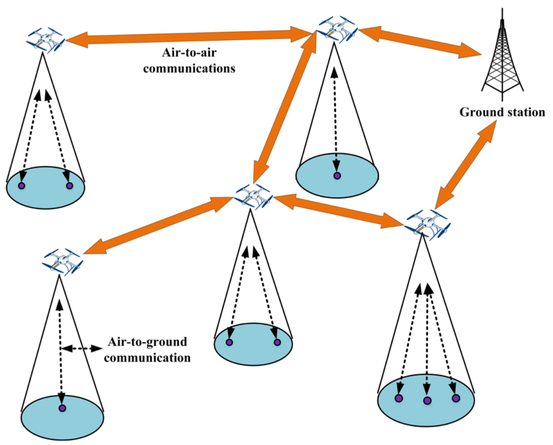
2. Communication Technologies for UAWSNs

A UAWSN consists of several components such as the UAV, sensors, and ground station. In a UAWSN, different kinds of communications are utilized, such as communication between sensor and cluster head, inter-UAV communication, and communication between the UAV and ground station. In UAWSNs, it is very important to provide survivability and reliability through redundant communications. Significant packet drop may happen because of link failure between the UAV and sensor nodes. In UAV networks, IEEE 802.11 medium access control (MAC) protocols are widely used for the communications between UAV and the ground station because they are suitable for long-range communication and can handle higher bandwidth with high data rate. In inter-UAV communications, the link quality fluctuates because of the high mobility of UAVs, dynamic topology change, and communication distances between UAV nodes.
For the above-mentioned three kinds of communication links, different protocols are used. In Table 1, various communication technologies used in UAWSNs for different applications are summarized and compared based on physical characteristics and communication parameters at the physical and data link layers. In UAWSNs, the two categories of communication technologies are employed, which are wireless personal area networks (WPANs) [21,22,23] and wireless local area networks (WLANs) [24,25,26,27,28,29,30].

UAV Deployment in Fifth-Generation (5G) Technology

Recently, due to the significant deployment of Internet of things (IoT), UAV-aided IoT (UAIoT) was studied in industrial and academic research. In UAIoT, UAV is able to access the IoT ground network directly or via the machine-to-machine gateway. Furthermore, using the fifth-generation (5G) technology in IoT enhances the efficiency and coverage of UAIoT communication. In Reference [31], the authors introduced a case study on the application of UAVs along with traditional cellular infrastructures in future systems such as 5G networks. The authors investigated the compatibility of UAVs with the traditional cellular infrastructures to enable high data rate requirements, which may improve the energy efficiency for the 5G and beyond systems. Furthermore, the authors in Reference [31] presented UAV channel modeling, path planning for UAV networks, and finally routing for UAVs in disaster-resilient networks. In addition, the authors introduced the concept of using cognitive radio as an enabling technology for using UAVs in 5G networks.
In Reference [32], the authors presented a comprehensive survey on UAV communication toward 5G wireless networks. The authors described the network architecture and essential background of the space–air–ground integrated networks. In addition, the authors presented UAV-based swarm networks, which are multi-UAV networks that provide ubiquitous connectivity to ground users.
There are some technical challenges for the integration of UAVs in currently deployed 5G networks, which include channel characterization, path planning for UAVs, energy charging efficiency, and the integration of UAVs and IoT systems. Channel estimation and modeling are essential to determine the number of UAVs to coverage, the optimal altitude of UAVs, and the communication fairness between UAVs and ground users. The deployment of UAVs in city areas needs to consider the path loss. UAVs are operated by mostly limited battery power and, thus, the operation of UAVs is constrained by their limited onboard power. For this reason, it is essential to consume power judiciously to fulfill both flight and communication. In UAWSNs, an optimal flight path is essential for data collection. A single UAV can be enough for data collection. However, to provide communication facilities for the ground users, a multi-UAV network needs to be considered.
Limited energy is the bottleneck in UAV networks. However, recent developments in battery technology such as lithium-ion and hydrogen fuel cell batteries perform well for long-time UAV flight. Moreover, energy harvesting can be used to extend the UAV flight duration by utilizing green energy such as solar energy. Novel energy delivering technologies such as wireless power transfer can be smart solutions to enhance the charging efficiency. Due to the unique UAV features such as rapid mobility, fast deployment, easy programmability, and scalability, UAVs can be applied to future IoT systems and UAIoT can be a promising solution to realize the framework of future IoT systems. The 5G network technology can play a vital role in efficient UAIoT communication.

3. Taxonomy

The network architecture of UAWSNs is quite different from that of traditional WSNs. Therefore, the existing routing protocols for stationary or low-mobility WSNs are impractical to apply. Routing protocols for UAWSNs must adapt to networks’ high mobility, sudden changes in network topology, and sporadic communication links. In general, WSNs require different quality of service (such as delay, packet loss, and reliability) on the underlying networks. In addition, WSNs have limited energy resources, low node computation power, and limited network resources. To meet the requirements while respecting the limitations of WSNs, appropriate routing metrics are curial parameters to design an efficient routing protocol. In Reference [33], the authors analyzed the routing metrics, which guarantee convergence, optimality, and loop freeness of the routing protocol, resulting in a low-power and lossy network. In Reference [34], the authors provided guidelines for designing efficient composite routing metrics to be applied to the routing protocol for low-power and lossy networks. In Reference [34], the authors discussed and defined the different routing metrics such as basic metric, derived metric, composite metric, composite function, optimal path, sub-path, path weight, metric order relation, and metric operation. As explained in Reference [34], the composition of several basic or derived routing metrics into a composite routing metric is a challenging problem. Moreover, the authors provided guidelines for the proper selection and composition of basic metrics for applicability to the routing protocol.
The routing protocols can be classified into two categories: network structure-based routing [21,22,23,24,25,26,27,28,29,30,31,32,33,34,35,36,37,38] and protocol operation-based routing [39,40,41], as shown in Figure 1. The network structure-based routing is further classified into flat routing [35,36,37,38], hierarchical routing [39,40,41,42,43,44,45,46,47,48,49,50], and location-based routing [51,52]. The protocol operation-based routing is also classified into three categories: swarm intelligence routing [53], multi-path routing [54], and shortest-path routing [55]. The routing protocols are technically examined and qualitatively compared with each other in the next two sections.

4. Routing Protocols for UAWSNs

All the routing protocols are investigated in this section with regard to their operational principles and distinguishing characteristics. In general, routing is included in data gathering and aggregation schemes in UAWSNs. This is mainly because data gathering requires routing from sensors to the sink or base station.

4.1. Network Structure-Based Routing

In network structure-based routing, the way that nodes are connected and how they exchange information depend on the network architecture. Flat routing, a type of network structure-based routing, combines all the sensor nodes together to perform sensing, and all nodes have the same role to play in the network. On the other hand, hierarchical routing has sensor nodes that play different roles in the network. For example, some nodes may send data to the sink node, whereas others may perform the task of sensing only. In tree-based routing, a routing tree is formed among the sensor nodes and the UAV-based sink node is the root of the tree. Location-based routing, which is another type of network structure-based routing, operates on the basis of two assumptions: (a) nodes are position-aware and have knowledge about the position of their neighbors, and (b) the message contains the location information of the destination node.

4.1.1. Flat Routing

Hybrid heuristic approach (HHA): Mazayev et al. worked on data gathering via UAVs in WSNs that have a delivery-limit constraint [35]. The network is assumed to be a wireless sensor network graph, where a set of UAVs have a different limited buffer size. There are time-window constraints for UAV nodes along with the delivery limit. The goal is to find an efficient set of paths for the UAVs to accumulate sensor data at certain places and deliver these data to the sink node by fulfilling the mentioned constraints. A mathematical analysis of the problem, along with the hybrid heuristic approach (HHA), was also presented. The heuristic approach includes an improvement mechanism, which is well suited for the data-gathering purpose of UAVs. The simulation results showed that the heuristic is capable of solving the problem for a wide range of data sets and deadline ranges. The protocol can be improvised further to work with multiple base stations and self-managing UAV nodes in clusters.
UAV-enabled sensor node (SN-UAV): SN-UAV [36] is a flat-topology routing protocol that addresses the problem of energy scarcity and network lifetime for the UAV working as a mobile data collector for sensor nodes (SNs). The wake-up schedule of the SNs and the trajectory of the UAV are optimized in a combined way to reduce the energy consumption while confirming that the amount of data needed is gathered from every single WSN. In SN-UAV, UAVs are deployed as mobile data collectors to obtain data from SNs in the ground. The optimization problem of the wake-up schedule and the UAV trajectory is designed as a mixed-integer non-convex problem, which is solved using an iterative algorithm. The technical strength of SN-UAV lies in its reliable data collection in the fading channel. The protocol is also suitable for multi-UAV scenarios.
UAV–WSN-based border surveillance (UAV–WSN): To prevent dangerous entities from entering, UAWSNs can be a promising technology for border surveillance. Owing to this concept, Laourira et al. proposed a multilayer hybrid architecture to design a surveillance system for border monitoring by using cameras, scalar sensors, radars, and UAVs [37]. They also addressed an activation scheduling strategy based on load balancing and energy saving. The main purpose and aim of the proposed scheme in Reference [37] is to track and detect any border intrusion in the possible human involvement. There are three kinds of nodes used in the network. They are scalar sensors, multimedia sensors, and UAVs. They collaborate with each other to build an efficient intrusion detection system. Scalar sensors form the first layer called the detection layer. This layer is responsible for intrusion detection. Once the scalar sensors detect any kind of intrusion, an alert is sent to the multimedia sensor nodes which constitute the second layer of the network. Finally, UAVs are called upon to track the intruder after they receive necessary information from the multimedia sensor nodes. The majority of existing UAV-aided systems suffer from a decreased network lifetime that is overcome in the scheme proposed in Reference [37]. Although the network is designed with three-layer hierarchy, data transmission (i.e., routing) among the three layers is flat-based. That is why UAV–WSN is classified as flat-based routing.
UAV-based automated sensor deployment for mobile sink (UAV-AS-MS): Gomez et al. proposed a new method that combines a heterogeneous WSN based on a multi-agent system and a mobile agent (UAV) for data acquisition in places that are inaccessible for a human being [38]. The goal is to automate the network deployment and data acquisition. The primary concern is to facilitate data gathering beyond the communication range of sensor nodes in the network. According to Reference [38], a UAV is responsible for transporting and releasing sensors at a certain location that is considered dangerous to access through direct human intervention. The UAV collects data automatically, following an optimal route that covers all the sensors in the network. A vehicle routing problem (VRP) is formulated and subsequently solved to determine the optimal route. The routes of the UAV were pre-planned in Reference [38]. For this reason, the sensor nodes in the network could turn on the radio exactly when the UAV was close by. This phenomenon was responsible for the high energy efficiency in the network. The avoidance of multi-hop routing facilitated the energy efficiency as well.

4.1.2. Hierarchical Routing

In hierarchical routing, sensor nodes are assigned to perform tasks, such as aggregation and forwarding. In hierarchical routing, high-energy nodes perform data aggregation, and low-energy ones perform data sensing, as shown in Figure 2.
Hierarchical routing is popular for WSNs because of its energy-conservation effect. Linear sensor routing, cluster-based routing, and tree-based routing are three types of hierarchical routing. Many applications involve placing the wireless sensors in a linear arrangement.

Linear Sensor Routing

In a linear WSN, nodes are placed in a single straight line, forming a thin linear sensor network (LSN). Furthermore, if all the nodes remain between two parallel lines that stretch for a long distance relative to the transmission range, they constitute a semi-linear or thick LSN. The type of routing involved with LSNs is defined as linear sensor routing. Cluster-based routing is highly suitable for WSNs because it reduces the number of data transmissions and saves energy. Sensor nodes are arranged into clusters, where a particular node is designated as the CH that is in charge for communication with the base station or sink node.
UAV-based liner sensor network (ULSN): Routing the data in a multi-hop fashion in LSNs that can extend even up to hundreds or thousands of kilometers can cause high-energy dissipation. A UAV-based liner sensor network (ULSN) [39] deals with such a problem using UAVs. Four kinds of nodes are defined in the system. They are sensor nodes (SNs), relay nodes (RNs), UAVs, and sink nodes. SNs are basic sensor nodes assigned to gather data from the environment. RNs collect information from the nearest sink nodes, and UAVs move along the LSN to collect data from the sink nodes. Sink nodes are placed at both ends of the LSN. SNs use a normal and non-complex algorithm to transmit data to the nearest RN. RNs act as CHs and transfer data to a moving UAV. Finally, the UAV carries the data to the sink node. This procedure of the ULSN decreases the energy consumption significantly because of the reduction of transmission ranges from the SN to the RN and the use of one-hop transmission from the RNs to the UAV. The ULSN can also reduce the interference among RNs caused by the hidden-terminal problem. One drawback of Reference [39] is that the total travel time that a UAV may take while traversing a big LSN was not considered.

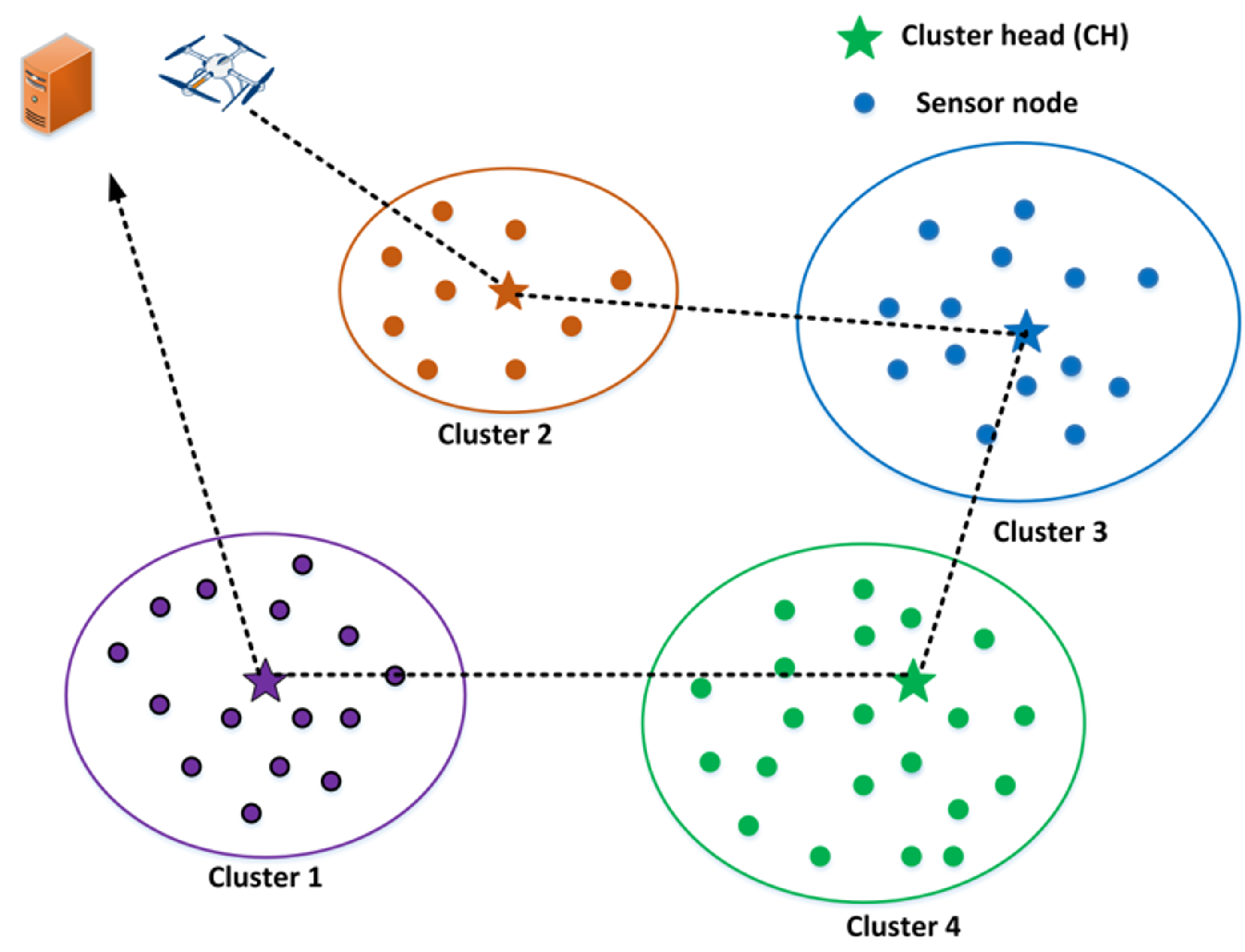
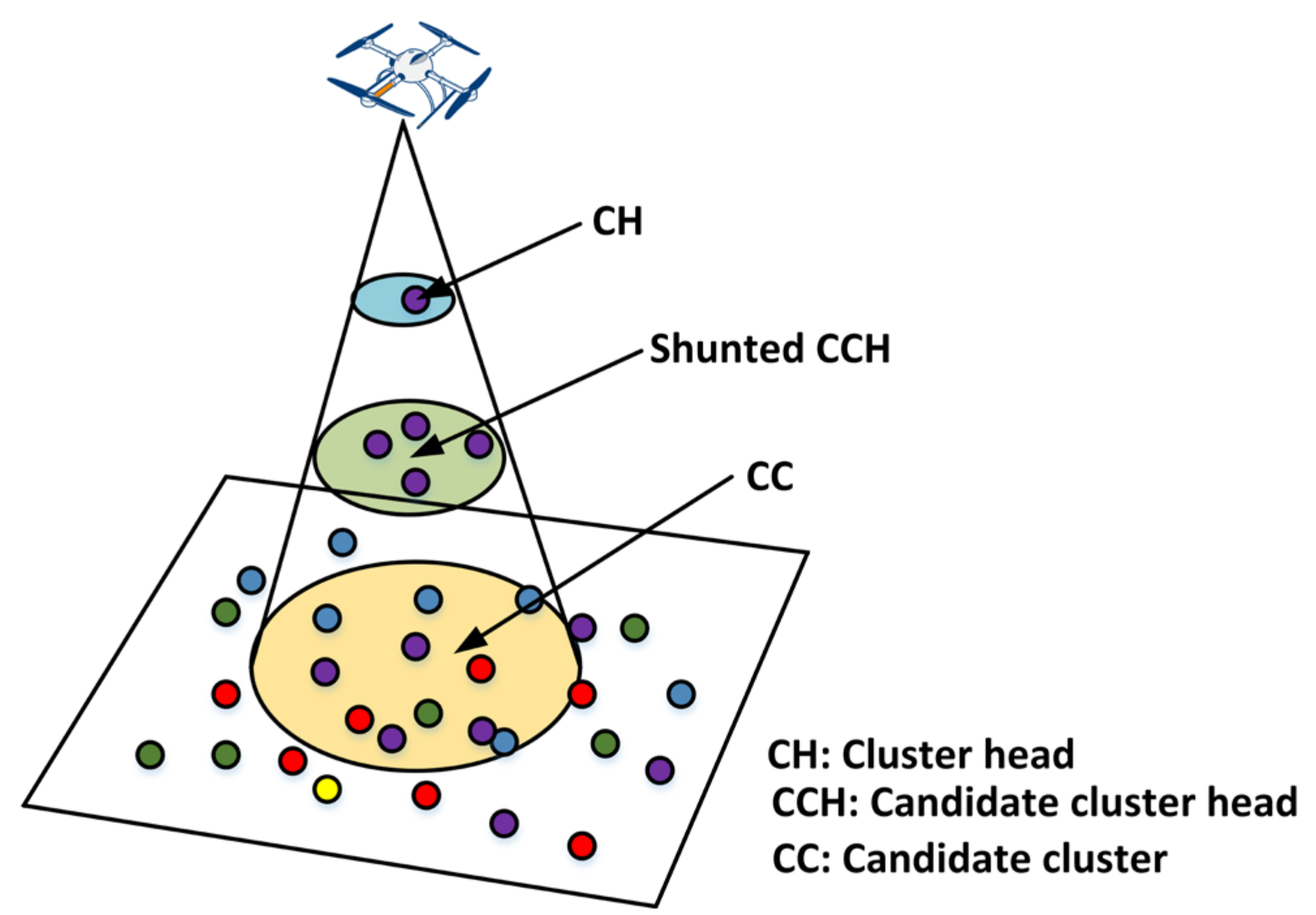
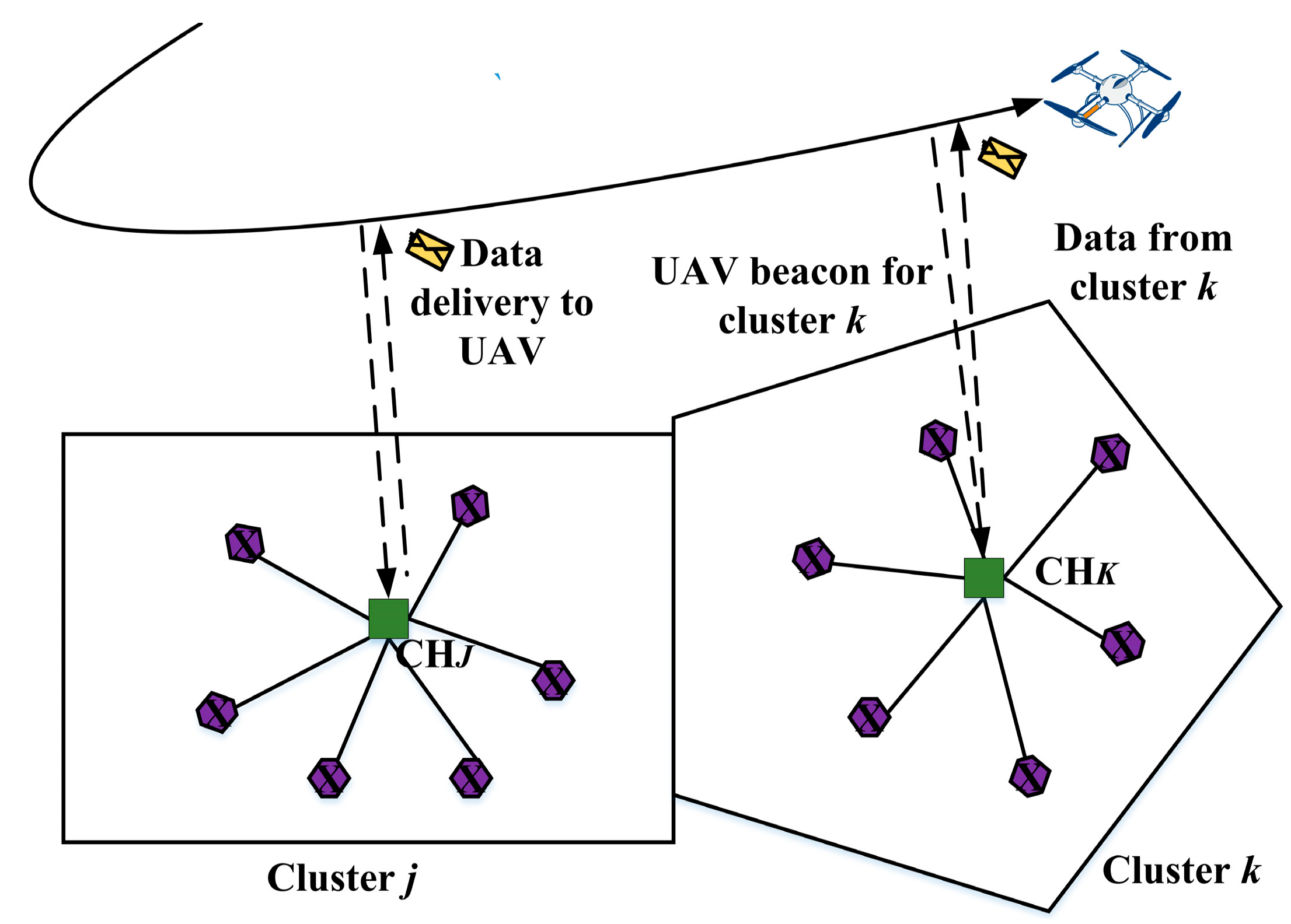
Cluster-Based Routing

In cluster-based networks, nodes are divided into several virtual groups. In the clustering schemes, nodes are allocated a different purpose such as CH, cluster gateway (CGW), and cluster member (CM). The CH functions as a local coordinator for its cluster, performing inter-cluster communication and data forwarding. CGW is a non-CH node with inter-cluster links. CGW is used to access neighboring clusters and exchange information between clusters. Ordinary nodes are called as CMs. It was shown that cluster schemes perform better in a large area with a large number of nodes. There are several objectives for clustering in UAWSNs. Scalability and reliability, fault-tolerance, maximal network lifetime, and energy efficiency are the most common objectives among them. In a multi-UAV network, one ground station is used to control one or more UAVs. The ground station controls the UAV directly without any air-to-air (A2A) communication links. However, this scheme does not perform well on a large scale. A centralized-based scheme does not scale well for large UAV networks. In cluster-based schemes, deployed UAVs may be minimized, and area coverage may be maximized. A cluster-based routing protocol, which provides energy efficiency, and clustering schemes help to increase the network lifetime. In cluster formation, all nodes are allowed to make independent decisions to generate efficient clusters.
Clustering properties are divided on the basis of the cluster characteristics such as size of the cluster, the number of clusters, intra-cluster communication, and inter-cluster communication. The number of clusters may be either constant or variable. The size of the cluster may be equal or unequal. In cluster-based routing, the communications within the cluster may be either direct or multi-hop. In clustering approaches where the cluster size is large and the number of CHs is small, multi-hop communication between CH and CMs may be needed. Since the nodes are equipped with long range, they require a multi-hop approach for communication. CH election is a major part of a clustering scheme. The election of CHs has a substantial effect on the cluster-based routing performance. In cluster-based routing, CHs may be either stationary or moveable. In general, CHs may move within a limited area. For moveable CHs, the cluster topology is a complex task. CHs may perform a vital role such as relay, aggregation, and fusion in clustering approaches. A CH performs as a relay node for controlling the data, data aggregation operation, and synchronization. In cluster-based routing, CH position is important. The position of the CH may be distributed, dynamic, centralized, or hybrid. The distributed approach is widely used because all nodes get the opportunity to serve as a CH in this approach.
In UAWSNs, the UAV acts as a mobile sink node. This is a smart approach to collect data from sensors. CH election is the noteworthy process in clustering approach. CH can be elected by various processes. Most of the clustering approaches use proactive clustering rather than reactive clustering. The proactive routing tables are updated through the exchange of periodic messages, whereas the reactive clustering is based on the data-centric method. In reactive routing, maintaining a routing table is not necessary and, when a node requires sending data, it finds a new route. In highly dynamic routing, finding a new route repeatedly results in colossal routing overhead. Based on the resource of sensor nodes, UAWSN can be classified into two categories of homogeneous and heterogeneous networks. In the homogeneous network, all sensor nodes have the same capabilities of energy, communication resources, and computation power, and CHs are selected according to a random manner. On the other hand, in the heterogeneous network, nodes have unequal capabilities. For this reason, CH selection is important in heterogeneous networks. Normally, the node with more capabilities is selected as a CH in heterogeneous networks.
UAV-assisted routing protocol (URP): URP [40] is a crop health-monitoring system developed using a UAV-aided clustered WSN. Collecting data from WSNs deployed in farm fields is challenging because of extreme weather conditions, like high temperature, dry weather, sandstorms, and remote locations. To overcome these challenges, the authors of Reference [40] proposed a dynamic data-collection mechanism using UAVs as shown in Figure 3. The dynamic clustering in URP is illustrated in Figure 3. In URP, every CH node participates in the CH selection process based on node probability calculated using a Bayesian classifier. In the routing phase, nodes are classified into three types, namely, CMs, candidate clusters (CCs), and candidate CHs (CCHs). Finally, to nominate a node as a CH, the UAV and CCHs participate in the CH selection process.
The system has a large number of sensors deployed to monitor different parameters of the crops, soil, and environment. The role of the UAV in the system is to create a communication infrastructure between the end users and sensing devices. Sensing devices are grouped based on their geographical locations using a clustering method. After that, nodes near the pathway of the UAV are selected as CHs to transmit data to the UAV. The most significant advantage of URP is that it can be deployed anywhere without any prior infrastructure, and it massively increases network lifetime. The protocol can be implemented in a multi-hop manner in the future.
Cooperation-based UAV and WSN (C-UAV-WSN): It is easier to manage UAV and WSN as separate independent units. Combining two different paradigms can lead to increased performance, but it makes the network complex to handle. To deal with this issue, the cooperation between UAV and WSN (C-UAV-WSN) [41] can lead to optimal cooperation between the WSN and UAV in two ways. One is the inclusion of WSN operation for updating the UAV flight plan, and the other is the consideration of UAV trajectory to facilitate data acquisition. In the network model of Reference [41], the WSN is assumed to be deployed on the ground and the nodes are supposed to organize themselves into clusters as shown in Figure 4. CMs collect data and send them to the CHs periodically. The CHs must aggregate the data before delivery to a UAV. The role of the CH is rotated within the network, and the transmission range of the new CHs fixes the flying zones for the UAV. The energy consumption and network lifetime were remarkably improved in Reference [41]. The main drawback of this system was its inability to perform better in large-scale sensor networks.
Hybrid and energy-efficient distributed (rHEED): When a large number of sensor nodes are deployed in a geographical area, the energy-hole problem can be an issue that can cause nodes closer to the static sink node to die faster. A received signal-strength indication (RSSI)-based hybrid and energy-efficient distributed (rHEED) protocol [42] is a clustering scheme in WSNs that incorporates UAV-based mobile sinks to overcome the energy-hole problem. Its network model consists of sensor nodes that collect data and transmit them to CHs. Then, all the CHs forward their data to the mobile sink node, which is the UAV. It is assumed that the UAV can move in three dimensions with variable speeds. The protocol can successfully prevent unnecessary cluster formation using the UAV path as a parameter to form the clusters. rHEED does not consider wind effects and UAV travel time over a large-area network, which are major drawbacks of this protocol.
UAV-assisted data gathering (UADG): In UADG [43], the issue of concurrent data transmission between densely populated sensor nodes and high-speed UAVs working as sink nodes is exploited. In UADG, a data-acquisition algorithm is introduced, which involves the UAV and mobile agents (MAs) for autonomous data collection and processing. Sensor nodes are grouped in UADG, and a node with the highest residual energy is elected as a leader node among the nodes in a group. MAs also collaborate with one another to avoid redundant visits to the leading nodes. MAs must finally return to the UAV with the integrated data. Even though UADG is energy-efficient, it does not consider parallel processing of the mobile nodes, which could further increase the performance.
Dynamic programming-based algorithm (DPBA): Because of limited resources in WSNs, it is quite challenging to allocate them wisely to increase the data transmission rate. In the dynamic programming-based algorithm (DPBA) [44], bandwidth and energy allocation are incorporated to increase the total transmission rate. A two-layer paradigm is taken under consideration to design the network model of the protocol. In the first layer, sensor nodes sense data from the environment and transfer them to UAVs. In another layer, UAVs send the gathered data to the outside world. Only the first layer was considered in Reference [44]. The whole system is time-slotted. UAVs move along their trajectories over a sensor field to gather the data from the sensor nodes. The protocol can increase the overall data transmission rate. The protocol, however, does not allow for the prospect of multiple UAVs collecting data from the sensor field.
Energy-efficient data gathering framework (EEDGF): In Reference [45], the authors proposed a multi-UAV network-oriented energy-efficient data gathering framework (EEDGF) in deadline-based WSNs, which can be used in various UAV-based applications. In a large WSN, the sensed data can be easily collected in saved time with UAVs, as shown in Figure 5.
This work gives a framework for deadline-based multi-UAV WSNs by formulating an integer linear programming model. The probability that the line of sight (LoS) between UAVs and sensor nodes is given depends on the environment, device location, and elevation angle. UAVs use nodes’ geo-location from their GPS to find the optimal route. The authors of Reference [45] compared their proposed algorithm with a greedy algorithm. The greedy algorithm could find a local solution, but it was not possible for the algorithm to observe the situation globally. As the goal was to find an energy-saving and time-bound method, it seems that the proposed scheme outperformed the greedy approach.
Projection-based comprehensive data gathering (PCDG): Ebrahimi et al. proposed the use of UAVs to collect data from extremely dense WSNs using projection-based comprehensive data gathering (PCDG) [46]. Comprehensive data gathering (CDG) is used to aggregate data from cluster members to their CHs. This can successfully reduce the number of transmissions that lead to the reduction of energy consumption. The UAV is responsible for data transfer to a remote sink node, avoiding the need for long-range transmissions or multi-hop communication among sensors. After an optimized forwarding tree per cluster is constructed, the sensed data are gathered from selected CHs based on projection-based CDG with minimized UAV flight distance. In Reference [46], the joint problem of optimized node clustering, forwarding tree construction, CH selection per cluster, and UAV trajectory planning for energy-efficient data collection was mathematically modeled and analyzed. According to the performance results, the PCGD outperformed other approaches for small-, medium-, and large-size network scenarios.

Tree-Based Routing

In tree-based routing, a tree is formed among the all sensor nodes and a sink is the root of the tree. In UAWSNs, the UAV functions as a sink node. All leaf nodes send their data to the respective parent. Each parent node is responsible for aggregating the received data and forwarding the data to the next-level parent node toward the sink.
Aerial-based data collection (ADCP): Data collection is a crucial factor for WSNs. Traditional WSNs use sink nodes to collect the sensed data, but this technique is not feasible for mobile sensors deployed for some specific applications such as wildlife monitoring, tracking in smart cities, and monitoring sports events. To address this issue, Caillouet et al. proposed a data collection and tracking mechanism using a fleet of flying devices (drones) [47]. The main objective of the scheme is to deploy a set of UAVs in a three-dimensional space to cover and collect data from all the mobile sensor nodes using ground-to-air communication. The gathered data are transmitted to the central base station using multi-hop air-to-air communication through UAVs. The optimization of special and temporal coverage with mobile flying drones is formulated as the aerial data collection problem (ADCP) as shown in Figure 6. The authors attempted to fill the gap between the practical networking approach and the theoretical approach through the evaluation and comparison of data collection and tracking algorithms.
Hybrid UAV-aided WSN routing (H-UAV-WSN): When a WSN is formed with thousands of sensor nodes and a traditional immobile sink node, this may result in inefficient area coverage and decreased network performance. To deal with this issue, Popsecu et al. proposed a hybrid UAV–WSN (H-UAV-WSN) network that can be self-configured for the improvement of data gathering across large areas [48]. The routing scheme firstly establishes a decentralized multi-level architecture. The UAV is fitted with a sink node that acts as a data collector. In addition, the UAV can behave as a relay to connect WSNs to a remote base station depending on the application requirement. Such a feature enhances the connection between ground WSNs and the base station. Based on the trajectory, two stages are considered. Firstly, a discovery trajectory is planned. Secondly, a trajectory is planned for data acquisition, which passes through the neighborhoods of CHs. The trajectory is planned in a way that guarantees communication time and obstacle avoidance. However, any collaboration between ground WSNs and UAVs is not taken into account in forming clusters.
Topology-aware data aggregation (TADA): In Reference [49], UAV-based data aggregation of WSNs was reported. Traffic volume can be significantly reduced using comprehensive sensing (CS). The existing approaches based on CS have limitations such as excessive overhead in broadcasting and high errors in data reconstruction process. Addressing these issues, Wang et al. proposed a topology-aware data aggregation (TADA) protocol that can sustain the advantages of CS-based schemes while alleviating the previously mentioned issues. One of the main features of TADA is its ability to utilize the topology information to rebuild the raw data with higher precision. The mechanism of weight coding is identical to CS in TADA, but TADA can successfully achieve a short weight vector which results in lower energy consumption. The construction of a measurement matrix representing the scaling of WSN makes TADA more adaptive to dynamic changes in WSN topology. At the beginning of the proposed protocol, a balanced tree-based topology is constructed. The simulation outcomes demonstrate that the TADA scheme shows better performance in comparison to two typical CS-based protocols in terms of the energy efficiency of data aggregation, data reconstruction error rate, and storage requirement. However, the protocol ignores the effect of link transmission failure. In addition, packet loss could severely downgrade the performance of data gathering.
UAV-aided compressive data gathering for WSN (UAV-CDG): In UAV-CDG [50], the authors addressed the problem of data collection, in which data can be located in hard-to-reach areas and data collection is normally extremely energy-constrained, in order to design an effective energy-aware data collection mechanism. A UAV is used to collect data in dense WSNs by using projection-based compressive data gathering (CDG). CDG is employed to aggregate data from a large set of sensor nodes, in which the selected projection nodes act as cluster heads (CHs). The CDG method reduces the number of transmissions, leading to remarkable energy savings and prolonging network lifetime. After that, the UAV transfers the gathered data from the CHs to the base station, which avoids the need for long-range transmissions or multi-hop communications. In UAV-CDG, the deployed sensor nodes are divided into clusters, and a forwarding tree for clusters is constructed on the basis of the CDG technique, decreasing both the total transmission power in the network and the total UAV trajectory distance. Simulation results showed that UAV-CDG significantly improves the performance in terms of energy saving, flight distance, and total number of transmissions.

4.1.3. Location-Based Routing

Energy-efficient localization and UAV-based WSN (EEJLS-WSN-UAV): In energy-efficient joint localization in a UAV-based WSN (EEJLS-WSN-UAV) [51], localization and synchronization for UAWSNs are exploited. The information of localization and synchronization is required for UAVs to know the position of the sensor nodes and global time to relate event detection at a specific location and time. One easy way to provide this information to all the sensor nodes is to equip them with a GPS. This method is simple but costly. In Reference [51], a method of three-dimensional localization and synchronization was introduced, where a UAV equipped with GPS roams around the sensor field broadcasting its geographical position and clock time. In this way, the sensor nodes in the sensor field can estimate their geographical position and global time without having a GPS of their own. As a result, the number of beacon nodes required in the network is decreased. This scheme also provides higher accuracy of estimating localization information and local timing compared to earlier algorithms. One drawback of EEJLS-WSN-UAV is that it does not consider the time taken for a GPS-equipped roaming UAV to empower other nodes in the sensor field. Route optimization of UAVs is necessary if huge numbers of sensor nodes are deployed. In a future improvement of EEJLS-WSN-UAV, it may be possible to optimize the flight path to reduce the time required to cover the entire network area.
Location-based UAV-aided WSN (LS-UAV-WSN): Event-based WSN requires a faster response in data processing and offloading. Location service in a UAV-based WSN (LS-UAV-WSN) [52] is based on a distributed algorithm, which autonomously and independently drives a mobile sink node toward the static sensor nodes in a WSN for data acquisition. Mobile sinks directly infer and compute the network trajectory. In addition, all the nodes are assumed to be position-aware. When a node has data to transmit, it broadcasts a source advertisement packet at a certain time interval that contains its identifier (ID) and exact position. Nodes that receive the packet must check its ID and broadcast it again after a certain timeout. Mobile sinks also can send a sink advertisement after the expiration of a particular time interval. The energy consumption is significantly reduced and, thus, the network lifetime is prolonged.

4.2. Protocol Operation-Based Routing

As discussed earlier, protocol operation-based routing can be divided into two distinct categories: swarm intelligence routing and multi-path routing. Network management for UAV-based WSNs is gradually becoming more difficult because this technology is becoming more widespread. The network size, rapidly changing topology, and network complexity inspired algorithms based on swarm intelligence. This kind of algorithm depends on the interaction of a multitude of simultaneously interacting agents. Multi-path routing involves multiple alternative paths in a UAV-based network that can maximize the benefit in terms of fault tolerance, bandwidth, and security.

4.2.1. Swarm Intelligence Routing

Particle swarm optimization (PSO)-based UAWSNs: In PSO-WSN-UAV [53], the issue of determining the network topology of a WSN and the use of UAVs for data collection are exploited. PSO is used to reduce the energy consumption, improve the communication quality, and reduce the traveling time, as shown in Figure 7.
The topology is formed in a way that requires CHs to contact the UAVs. Typical WSNs use a clustering protocol, such as low-energy adaptive clustering hierarchy (LEACH), to conserve energy, but WSNs that are associated with UAVs and subject to large-scale deployment need a more complex and robust method. In Reference [53], a PSO-based method was presented, which works to find the optimal topology to decrease the energy consumption, UAV travel time, and bit error rate (BER). According to the simulation results, it outsmarts LEACH in terms of energy consumption and BER. The unique contribution of Reference [53] was to consider the wind effect in the travel time of UAVs.

4.2.2. Multi-Path Routing

Frame selection-based routing protocol (FSRP): The FSRP is a routing algorithm for UAWSNs along with a data-acquisition framework, as shown in Figure 8. Efficient data gathering is a challenging task in WSNs.
In FSRP [54], a data-acquisition framework is introduced to increase the efficiency of data gathering in a WSN using UAVs. To increase the network throughput, redundant data transmission between static sensor nodes and UAVs is restricted. This is done by using a priority-based frame-selection scheme. Nodes within the coverage of UAVs are classified into different frames based on their locations. The contention window value in IEEE 802.11 MAC is also adjusted for this purpose. A lower contention window range is assigned to the frame with high priority in an urgent area, and a higher contention window range is assigned to frames with low priority in unimportant areas. Based on this framework, FSRP aims to reduce the distance between senders and receivers to obtain better channel quality. At least one CH is responsible for data communication with a UAV. This decreases the distance between sensors. With a shorter distance, the channel quality becomes better, thus saving energy.

4.2.3. Shortest-Path Routing

Energy efficient UAV routing for WSN (EFUR-WSN): In EFUR-WSN [55], the authors addressed the problem of energy consumption for data transmission in UAV-enabled WSNs, where a UAV is dispatched to collect data from sensors. In EFUR-WSN, a Voronoi diagram-based algorithm is introduced for efficient UAV routes in order to conserve the residual energy of sensors. The optimization problem of data collection and UAV traveling distance is solved on the basis of two different methods. Firstly, a feasible UAV routing path is provided based on the Voronoi diagram, which provides UAV hovering locations with low computational complexity. The Voronoi diagram is extensively exploited by focusing on sensor energy information and UAV hovering location in order to prolong network lifetime. The shortest UAV route is considered for data collection at all sensors. Secondly, to minimize the UAV overall trajectory distance, the number of UAV hovering locations supporting multiple nodes needs to be maximized. By sequentially adjusting each UAV hovering location based on the status of sensor energy, the finally optimized route for UAV is obtained. Simulation results showed that EFUR-WSN outperforms the existing schemes in terms of energy-efficient data gathering and energy consumption. EFUR-WSN significantly reduces the energy consumption of sensors, resulting in prolonged network lifetime.

5. Comparison of Routing Protocols

In this section, the performance of existing routing protocols for UAWSNs is qualitatively compared in terms of routing policies and metrics, outstanding features, and characteristics. The routing policies and metrics of the existing protocols are summarized in Table 2.
Routing policies and metrics have a vital effect on the performance of routing protocols. Generally, WSNs have a large number of nodes with sensing, communication, and computation capabilities. The energy, bandwidth, and computational capacity are limited in sensor nodes. To achieve high-energy efficiency and a better lifetime, different routing protocols can be applied to different applications based on the operational environment. Routing policies and metrics for UAWSNs are summarized for each routing protocol in Table 2. From our study, it was found that the policies of optimized link routing and shortest-path routing are widely used in routing protocols for UAWSNs. In position-based routing protocols, however, the policies of distance-estimation routing and position computation-based routing are used. Major advantages and limitations of existing routing protocols in UAWSN are summarized in Table 3.
In Table 4, the 21 existing routing protocols in UAWSNs are compared with respect to various features, protocol operations, characteristics, and distinct performance factors. It should be noted that GPS and RSSI are widely used in most of the routing protocols to obtain the location information of UAVs. The design of a proper routing protocol in UAWSNs is dependent on the requirement, network scenario, and application of the target UAWSN. From our study, most of the routing protocols consider only a single UAV for collecting data from sensor nodes. On the other hand, a multi-UAV-oriented routing protocol can show a robust network lifetime, less energy consumption, and less end-to-end delay. It is generally known that sensor nodes are power-limited; therefore, energy efficiency is the most significant objective in the design of a routing protocol. As compared in Table 4, most of the routing protocols show better performance in terms of energy consumption by adopting UAV-based data gathering, collection, and distribution. An efficient routing protocol has lower energy consumption, lower end-to-end delay, communication reliability, fault tolerance, and scalability. A multi-path routing protocol ensures a high data-delivery ratio and communication reliability. Nevertheless, most of the routing protocols in UAWSNs do not consider load balancing as a routing metric.
The performance metrics, performance optimization, and application domains of integrated UAWSNs are synthesized in Table 5. It can be inferred from Table 5 that most of the protocols focus on energy consumption, efficient data transmission, and network coverage.

6. Open Research Issues and Challenges

In this section, important open research issues and challenges are addressed and technically discussed in the context of routing. The routing protocols for UAWSNs are still in their developmental phase and are subject to extensive continuing research. The major design goals of routing protocols in UAWSNs are prolonged sensor lifetime, improved network availability, reduced energy consumption, decreased delivery latency, and reduced routing complexity. Because a UAV has higher mobility, a longer deployment range, and a longer operation time than traditional mobile sensor nodes, important challenging issues are raised in routing for UAWSNs.

6.1. UAV Path Planning

One of the major drawbacks of existing routing protocols is the proper path planning of UAVs [56] for data collection over sensor nodes. The major challenges are to minimize the UAV routing path and flight time from the starting point to the destination node while allowing each sensor node to upload data successfully. Furthermore, to reduce the energy consumption and end-to-end delay, rapid path planning is necessary for UAV flight. The routing path should be separated into non-overlapping data-collection intervals.

6.2. Sensor-to-UAV Data Transfer

Uploading a certain amount of data to an in-flight UAV while using low energy is still challenging [57]. All existing routing protocols consider sensor data-collection missions in one-dimensional WSNs. However, a UAV routing path is three-dimensional. To detect the target node, UAV path planning and optimal mobility need to be investigated further.

6.3. UAV Coverage

The UAV coverage is another important issue. In UAWSNs, the coverage problem is categorized into three types: full/blanket coverage, target coverage, and path/barrier coverage [58]. The path coverage and target coverage are critical issues in UAWSNs. The existing routing protocols are based on full coverage in two-dimensional scenarios. In most of the existing routing protocols, a single UAV is deployed to collect data from the sensor nodes. Multi-UAV routing needs to be considered in future research for designing a routing protocol in UAWSNs.

6.4. Multi-UAV-Aided WSNs

A multi-UAV network [59] is a promising approach to reduce the data-collection time, end-to-end delay, and fault tolerance, as well as to increase communication reliability and network lifetime. UAV coordination and physical collision avoidance are emerging challenges in multi-UAV networks. In UAWSNs, the ferrying methodology can be further extended by a store-carry-forward (SCF) [59] mechanism. SCF is a suitable method for data forwarding, which can enable delay-tolerant delivery in UAWSNs.

6.5. Mobility

Control of the routing overhead is also important in UAWSNs [60]. The sensor nodes are assumed to be static. In the last few years, however, node mobility drew attention in many applications. For example, mobile sensor nodes are essential for medical applications and services. In such applications, sensor nodes need to transmit data continuously.

6.6. UAV Positioning

In position-based routing, accurate GPS information is required to discover the shortest routing path [61]. In some cases, such as disaster areas, the GPS signal can be weak or totally absent. Therefore, GPS information alone is not sufficient to locate the neighboring node. A low GPS signal or RSSI has a huge impact on position-based routing protocols [62]. It is not possible to discover a short path based on inaccurate signals.

6.7. Security

Security is very important in routing for UAWSNs because sensor nodes and their communications are extremely vulnerable to various security problems [63]. Encryption, identity verification, link verification, and authentication broadcasting can protect the sensor network’s routing protocols against external attacks, bogus routing information, flooding attacks, and acknowledgment spoofing.
In summary, the design of an efficient routing protocol to meet different design criteria is a promising direction to enhance the routing performance in UAWSNs. Further research should be performed on UAWSNs to achieve high routing performance.

7. Conclusions

Routing in UAWSNs is a novel and rapidly growing research area with a limited set of research results. In this article, we presented a comprehensive and comparative study of the routing protocols for UAWSNs. The routing protocols were classified based on the network structure and protocol operations. Their principal operation and distinguished features were summarized, and they were compared with each other in terms of some primary parameters such as various routing policies and metrics, mobility patterns, data transmission techniques, energy efficiency, localization, and end-to-end delay. For various applications, the comparison results may help engineers and researchers to choose the most suitable protocol for their target applications. In addition, important open research issues and challenges were summarized and discussed.

Author Contributions

M.Y.A. and M.A.H. reviewed, analyzed, and summarized the routing protocols for UAWSNs. S.M. directed the research and contributed to the review and analysis of the protocols. The paper was drafted by M.Y.A. and M.A.H. and subsequently revised and approved by S.M. All authors have read and agreed to the published version of the manuscript.

Funding

This work was supported in part by the National Research Foundation of Korea (NRF) grant funded by the Korea government (MIST) (No. 2019R1F1A1060501).

Acknowledgments

The authors would like to thank the editor and anonymous referees for their helpful comments for improving the quality of this paper.

Conflicts of Interest

The authors declare no conflicts of interest.

References

  1. Arafat, M.Y.; Moh, S. A Survey on Cluster-Based routing protocols for unmanned aerial vehicle networks. IEEE Access 2019, 7, 498–516. [Google Scholar] [CrossRef]
  2. Arafat, M.Y.; Moh, S. Routing protocols for unmanned aerial vehicle networks: A survey. IEEE Access 2019, 7, 99694–99720. [Google Scholar] [CrossRef]
  3. Cho, A.; Kim, J.; Lee, S.; Kee, C. Wind estimation and airspeed calibration using a UAV with a Single-Antenna GPS receiver and pitot tube. IEEE Trans. Aerosp. Electron. Syst. 2011, 47, 109–117. [Google Scholar] [CrossRef]
  4. Semsch, E.; Jakob, M.; Pavlicek, D.; Pěchouček, M. Autonomous UAV surveillance in complex urban environments. In Proceedings of the 2009 IEEE/WIC/ACM International Joint Conference on Web Intelligence and Intelligent Agent Technology, Galveston, TX, USA, 15–18 September 2009; Volume 2, pp. 82–85. [Google Scholar]
  5. Oubbati, O.S.; Lakas, A.; Zhou, F.; Güneş, M.; Lagraa, N.; Yagoubi, M.B. Intelligent UAV-Assisted routing protocol for urban VANETs. Comput. Commun. 2017, 107, 93–111. [Google Scholar] [CrossRef]
  6. Barrado, C.; Meseguer-Pallarés, R.; Lopez, J.; Pastor, E.; Santamaria, E.; Royo, P. Wildfire monitoring using a mixed Air-Ground mobile network. IEEE Pervasive Comput. 2010, 9, 24–32. [Google Scholar] [CrossRef]
  7. Xiang, H.; Tian, L. Development of a Low-Cost agricultural remote sensing system based on an autonomous unmanned aerial vehicle (UAV). Biosyst. Eng. 2011, 108, 174–190. [Google Scholar] [CrossRef]
  8. Lottes, P.; Khanna, R.; Pfeifer, J.; Siegwart, R.; Stachniss, C. UAV-Based crop and weed classification for smart farming. In Proceedings of the 2017 IEEE International Conference on Robotics and Automation (ICRA), Singapore, 29–3 June 2017; pp. 3024–3031. [Google Scholar]
  9. Arafat, M.Y.; Moh, S. Location-Aided delay tolerant routing protocol in UAV networks for Post-Disaster operation. IEEE Access 2018, 6, 59891–59906. [Google Scholar] [CrossRef]
  10. Sánchez-García, J.; Reina, D.G.; Toral, S. A distributed PSO-Based exploration algorithm for a UAV network assisting a disaster scenario. Future Gener. Comput. Syst. 2019, 90, 129–148. [Google Scholar] [CrossRef]
  11. Gupta, L.; Jain, R.; Vaszkun, G. Survey of important issues in UAV communication networks. IEEE Commun. Surv. Tutor. 2015, 18, 1123–1152. [Google Scholar] [CrossRef] [Green Version]
  12. Hayat, S.; Yanmaz, E.; Muzaffar, R. Survey on unmanned aerial vehicle networks for civil applications: A communications viewpoint. IEEE Commun. Surv. Tutor. 2016, 18, 2624–2661. [Google Scholar] [CrossRef]
  13. Abdulla, A.; Fadlullah, Z.; Nishiyama, H.; Kato, N.; Ono, F.; Miura, R. An optimal data collection technique for improved utility in UAS-Aided networks. In Proceedings of the IEEE INFOCOM 2014–IEEE Conference on Computer Communications, Berlin, Germany, 27 April–2 May 2014; pp. 736–744. [Google Scholar]
  14. De Freitas, E.P.; Heimfarth, T.; Netto, I.F.; Lino, C.E.; Pereira, C.E.; Ferreira, A.M.; Wagner, F.; Larsson, T. UAV relay network to support WSN connectivity. Int. Congr. Ultra Mod. Telecommun. Control Syst. 2010, 309–314. [Google Scholar] [CrossRef]
  15. Arafat, M.Y.; Moh, S. Localization and clustering based on swarm intelligence in UAV networks for emergency communications. IEEE Internet Things J. 2019, 6, 8958–8976. [Google Scholar] [CrossRef]
  16. Zeng, Y.; Zhang, R.; Lim, T.J. Throughput maximization for UAV-Enabled mobile relaying systems. IEEE Trans. Commun. 2016, 64, 4983–4996. [Google Scholar] [CrossRef]
  17. Zeng, Y.; Zhang, R.; Lim, T.J. Wireless communications with unmanned aerial vehicles: Opportunities and challenges. IEEE Commun. Mag. 2016, 54, 36–42. [Google Scholar] [CrossRef] [Green Version]
  18. Wu, Q.; Zeng, Y.; Zhang, R. Joint trajectory and communication design for Multi-UAV enabled wireless networks. IEEE Trans. Wirel. Commun. 2018, 17, 2109–2121. [Google Scholar] [CrossRef] [Green Version]
  19. Jawhar, I.; Mohamed, N.; Al-Jaroodi, J.; Agrawal, D.P.; Zhang, S. Communication and networking of UAV-Based systems: Classification and associated architectures. J. Netw. Comput. Appl. 2017, 84, 93–108. [Google Scholar] [CrossRef]
  20. Pitre, R.R.; Li, X.R.; DelBalzo, R. UAV route planning for joint search and track missions? An information-value approach. IEEE Trans. Aerosp. Electron. Syst. 2012, 48, 2551–2565. [Google Scholar] [CrossRef]
  21. Chen, C.-J.; Chen, J.-A.; Huang, Y.-M. Intelligent environmental sensing with an unmanned aerial system in a wireless sensor network. Int. J. Smart Sens. Intell. Syst. 2017, 10, 696–717. [Google Scholar] [CrossRef] [Green Version]
  22. Trasviña-Moreno, C.; Blasco, R.; Marco, Á.; Casas, R.; Trasviña-Castro, A. Unmanned aerial vehicle based wireless sensor network for Marine-Coastal environment monitoring. Sensors 2017, 17, 460. [Google Scholar] [CrossRef]
  23. Militaru, G.; Popescu, D.; Ichim, L. UAV-to-UAV communication options for civilian applications. In Proceedings of the 26th Telecommunications Forum (TELFOR), Belgrade, Serbia, 20–21 November 2018. [Google Scholar] [CrossRef]
  24. Fadlullah, Z.M.; Takaishi, D.; Nishiyama, H.; Kato, N.; Miura, R. A dynamic trajectory control algorithm for improving the communication throughput and delay in UAV-Aided networks. IEEE Netw. 2016, 30, 100–105. [Google Scholar] [CrossRef]
  25. Frew, E.W.; Brown, T.X. Airborne communication networks for small unmanned aircraft systems. Proc. IEEE 2008, 96, 2008–2027. [Google Scholar] [CrossRef]
  26. Frew, E.W.; Brown, T.X. Networking issues for small unmanned aircraft systems. J. Intell. Robot. Syst. 2009, 54, 21–37. [Google Scholar] [CrossRef]
  27. Ho, D.; Shimamoto, S. Highly reliable communication protocol for WSN-UAV system employing TDMA and PFS scheme. In Proceedings of the 2011 IEEE GLOBECOM Workshops (GC Wkshps), Houston, TX, USA, 5–9 December 2011. [Google Scholar] [CrossRef]
  28. Hua, M.; Wang, Y.; Zhang, Z.; Li, C.; Huang, Y.; Yang, L. Power-Efficient communication in UAV-Aided wireless sensor networks. IEEE Commun. Lett. 2018, 22, 1264–1267. [Google Scholar] [CrossRef]
  29. Ali, Z.A.; Masroor, S.; Aamir, M. UAV based data gathering in wireless sensor networks. Wirel. Pers. Commun. 2018, 106, 1801–1811. [Google Scholar] [CrossRef]
  30. Huiru, C.; Weihong, H.; Xuanjiao, L.; Yeqian, L.; Guo, L. Design and experiment of a WSN sink platform based on fixed wing unmanned aerial vehicles. In Proceedings of the 2016 IEEE Advanced Information Management, Communicates, Electronic and Automation Control Conference (IMCEC), Xi’an, China, 3–5 October 2016; pp. 1271–1274. [Google Scholar]
  31. Naqvi, S.; Hassan, S.; Pervaiz, H.; Ni, Q. Drone-Aided communication as a key enabler for 5G and resilient public safety networks. IEEE Commun. Mag. 2018, 56, 36–42. [Google Scholar] [CrossRef] [Green Version]
  32. Li, B.; Fei, Z.; Zhang, Y. UAV communications for 5G and beyond: Recent advances and future trends. IEEE Internet Things J. 2018, 6, 2241–2263. [Google Scholar] [CrossRef] [Green Version]
  33. Karkazis, P.; Trakadas, P.; Leligou, H.C.; Sarakis, L.; Papaefstathiou, I.; Zahariadis, T. Evaluating routing metric composition approaches for QoS differentiation in low power and lossy networks. Wirel. Netw. 2012, 19, 1269–1284. [Google Scholar] [CrossRef]
  34. Zahariadis, T.; Trakadas, P. Design guidelines for routing metrics composition in LLN. draft-zahariadis-roll-metrics-composition-04 (work in progress), 23 November 2012. Available online: https://tools.ietf.org/html/draft-zahariadis-roll-metrics-composition-04 (accessed on 27 May 2019).
  35. Mazayev, A.; Correia, N.; Schütz, G. Data gathering in wireless sensor networks using unmanned aerial vehicles. Int. J. Wirel. Inf. Netw. 2016, 23, 297–309. [Google Scholar] [CrossRef]
  36. Zhan, C.; Zeng, Y.; Zhang, R. Energy-Efficient data collection in UAV enabled wireless sensor network. IEEE Wirel. Commun. Lett. 2017, 7, 328–331. [Google Scholar] [CrossRef] [Green Version]
  37. Laouira, M.L.; Abdelli, A.; Ben Othman, J.; Kim, H. An efficient WSN based solution for border surveillance. IEEE Trans. Sustain. Comput. 2019, 1. [Google Scholar] [CrossRef] [Green Version]
  38. Gomez, J.M.; Wiedemann, T.; Shutin, D. Unmanned aerial vehicles in wireless sensor networks: Automated sensor deployment and mobile sink nodes. Adv. Intell. Syst. Comput. 2018, 15, 943–953. [Google Scholar] [CrossRef]
  39. Jawhar, I.; Mohamed, N.; Al-Jaroodi, J.; Zhang, S. A framework for using unmanned aerial vehicles for data collection in linear wireless sensor networks. J. Intell. Robot. Syst. 2013, 74, 437–453. [Google Scholar] [CrossRef]
  40. Uddin, M.; Mansour, A.; Le Jeune, D.; Ammad-Uddin, M.; Aggoune, E. UAV-Assisted dynamic clustering of wireless sensor networks for crop health monitoring. Sensors 2018, 18, 555. [Google Scholar] [CrossRef] [Green Version]
  41. de Martinez Dios, J.; Lferd, K.; de San Bernabé, A.; Núñez, G.; Torres-González, A.; Ollero, A. Cooperation between UAS and wireless sensor networks for efficient data collection in large environments. J. Intell. Robot. Syst. 2012. [Google Scholar] [CrossRef]
  42. Okcu, H.; Soyturk, M. Distributed clustering approach for UAV integrated wireless sensor networks. Int. J. Ad Hoc Ubiquitous Comput. 2014, 15, 106. [Google Scholar] [CrossRef]
  43. Dong, M.; Ota, K.; Lin, M.; Tang, Z.; Du, S.; Zhu, H. UAV-Assisted data gathering in wireless sensor networks. J. Supercomput. 2014, 70, 1142–1155. [Google Scholar] [CrossRef]
  44. Zanjie, H.; Hiroki, N.; Nei, K.; Fumie, O.; Ryu, M.; Baohua, Z. Resource allocation for data gathering in UAV-Aided wireless sensor networks. In Proceedings of the 2014 4th IEEE International Conference on Network Infrastructure and Digital Content, Karlskrona, Sweden, 19–21 September 2014; pp. 11–16. [Google Scholar]
  45. Albu-Salih, A.; Seno, S. Energy-Efficient data gathering Framework-Based clustering via multiple UAVs in Deadline-Based WSN applications. IEEE Access 2018, 6, 72275–72286. [Google Scholar] [CrossRef]
  46. Ebrahimi, D.; Sharafeddine, S.; Ho, P.-H.; Assi, C. Data Collection in Wireless Sensor Networks Using UAV and Compressive Data Gathering. In Proceedings of the 2018 IEEE Global Communications Conference (GLOBECOM), Abu Dhabi, UAE, 9–13 December 2018. [Google Scholar] [CrossRef]
  47. Caillouet, C.; Giroire, F.; Razafindralambo, T. Efficient data collection and tracking with flying drones. Ad Hoc Netw. 2019, 89, 35–46. [Google Scholar] [CrossRef] [Green Version]
  48. Popescu, D.; Dragana, C.; Stoican, F.; Ichim, L.; Stamatescu, G. A collaborative UAV-WSN network for monitoring large areas. Sensors 2018, 18, 4202. [Google Scholar] [CrossRef] [Green Version]
  49. Wang, X.; Zhou, Q.; Cheng, C.-T. A UAV-Assisted Topology-Aware data aggregation protocol in WSN. Phys. Commun. 2019, 34, 48–57. [Google Scholar] [CrossRef]
  50. Ebrahimi, D.; Sharafeddine, S.; Ho, P.-H.; Assi, C. UAV-Aided Projection-Based compressive data gathering in wireless sensor networks. IEEE Internet Things J. 2018, 6, 1893–1905. [Google Scholar] [CrossRef]
  51. Villas, L.A.; Guidoni, D.L.; Maia, G.; Pazzi, R.W.; Ueyama, J.; Loureiro, A. An energy efficient joint localization and synchronization solution for wireless sensor networks using unmanned aerial vehicle. Wirel. Netw. 2014, 21, 485–498. [Google Scholar] [CrossRef]
  52. Zema, N.R.; Mitton, N.; Ruggeri, G. Using location services to autonomously drive flying mobile sinks in wireless sensor networks. In Ad Hoc Networks; Lecture Notes of the Institute for Computer Sciences, Social Informatics and Telecommunications Engineering.; Springer: Cham, Switzerland, 2014; Volume 140. [Google Scholar] [CrossRef]
  53. Ho, D.-T.; Grøtli, E.I.; Sujit, P.B.; Johansen, T.A.; Sousa, J. Optimization of wireless sensor network and uav data acquisition. J. Intell. Robot. Syst. 2015, 78, 159–179. [Google Scholar] [CrossRef]
  54. Say, S.; Inata, H.; Liu, J.; Shimamoto, S. Priority-Based data gathering framework in UAV-Assisted wireless sensor networks. IEEE Sens. J. 2016, 16, 5785–5794. [Google Scholar] [CrossRef]
  55. Baek, J.; Han, S.I.; Han, Y. Energy-Efficient UAV routing for wireless sensor networks. IEEE Trans. Veh. Technol. 2020, 69, 1741–1750. [Google Scholar] [CrossRef]
  56. Sun, P.; Boukerche, A. Performance modeling and analysis of a UAV path planning and target detection in a UAV-Based wireless sensor network. Comput. Netw. 2018, 146, 217–231. [Google Scholar] [CrossRef]
  57. Poudel, S.; Moh, S. Energy-Efficient and fast MAC protocol in UAV-Aided wireless sensor networks for Time-Critical applications. Sensors 2020, 20, 2635. [Google Scholar] [CrossRef]
  58. Huang, H.; Savkin, A.V. Viable path planning for data collection robots in a sensing field with obstacles. Comput. Commun. 2017, 111, 84–96. [Google Scholar] [CrossRef]
  59. Harounabadi, M.; Mitschele-Thiel, A. Applying message forwarding and replication to Multi-UAV message ferry networks. Mob. Netw. Appl. 2018, 23, 1337–1346. [Google Scholar] [CrossRef]
  60. Poudel, S.; Moh, S. Medium access control protocols for unmanned aerial Vehicle-Aided wireless sensor networks: A survey. IEEE Access 2019, 7, 65728–65744. [Google Scholar] [CrossRef]
  61. Nazib, R.A.; Moh, S. Routing protocols for unmanned aerial Vehicle-Aided vehicular Ad Hoc networks: A survey. IEEE Access 2020, 8, 77535–77560. [Google Scholar] [CrossRef]
  62. Fawaz, W.; Atallah, R.; Assi, C.; Khabbaz, M. Unmanned aerial vehicles as Store-Carry-Forward nodes for vehicular networks. IEEE Access 2017, 5, 23710–23718. [Google Scholar] [CrossRef]
  63. Mao, J.; Jiang, X.; Zhang, X. Analysis of node deployment in wireless sensor networks in warehouse environment monitoring systems. Eurasip J. Wirel. Commun. Netw. 2019, 2019. [Google Scholar] [CrossRef] [Green Version]
Figure 1. Taxonomy of routing protocols for UAWSNs.
Applsci 10 04077 g001
Figure 2. Data dissemination and gathering in a UAWSN.
Applsci 10 04077 g002
Figure 3. Data collection method in UAV-assisted routing protocol (URP).
Applsci 10 04077 g003
Figure 4. UAV-aided data gathering system.
Applsci 10 04077 g004
Figure 5. UAV and WSN communication.
Applsci 10 04077 g005
Figure 6. Multi-tier UAWSN network.
Applsci 10 04077 g006
Figure 7. Particle swarm optimization (PSO)-based shortest-path selection.
Applsci 10 04077 g007
Figure 8. General architecture of a UAWSN system.
Applsci 10 04077 g008
Table 1. Comparison of communication technologies for unmanned aerial vehicle (UAV)-aided wireless sensor networks (UAWSNs).
CategoryProtocolStandardPhysical SpecificationMobi-
lity
Data RateLatencyRadio RangeLink Types
WPANUWBIEEE 802.15.3Unlicensed, 2.4 GHz, TDMAYes22 Mbps<25 ns100 mSensor-to-CH link within short range.
ZigbeeIEEE 802.15.4Unlicensed, 2.4 GHz, DSSSYes<250 kbpsChannel access 15 ms100 mSensor-to-CH link within short range.
Zigbee-
Pro
IEEE 802.15.4Unlicensed, 2.4 GHz, DSSSYes<250 kbpsChannel access 15 msIndoor 1600 m
Outdoor 2500 m
Sensor-to-CH link within long range.
WLANWi-FiIEEE 802.11aUnlicensed, 5 GHz, OFDMYes54 MbpsSlot time: 9 μs,
SIFS: 16 μs,
DIFS: 34 μs,
Propagation delay: 1 μs
120 m OutdoorHigh data rate A2A and U2G
IEEE 802.11bUnlicensed, 2.4 GHz, DSSSYes11 MbpsSlot time: 20 μs,
SIFS: 10μs,
DIFS: 50 μs,
Propagation delay: 1 μs
140 m outdoorLow to medium data rate A2A and U2G
IEEE 802.11gUnlicensed, 2.4 GHz, DSSS, OFDMYes54 MbpsDIFS : 50 µs
SIFS : 20 µs
Slot time: 20 µs
140 m outdoorLow to high data rate A2A and U2G
IEEE 802.11nUnlicensed, 2.4 GHz and 5 GHz, DSSS, OFDMYes600 MbpsSlot time: 9 μs,
SIFS: 16 μs,
DIFS: 34 μs,
Propagation delay: 1 μs
250 m outdoorMedium to high data rate A2A and U2G
IEEE 802.11acUnlicensed, 5 GHz, QAMYes6933 MbpsDIFS : 34 µs
SIFS : 16 µs
Slot time: 9 µs
120 m outdoorHigh data rate A2A and U2G
UWB: ultra-wideband; CH: cluster head; DSSS: direct sequence spread spectrum; TDMA: time division multiplexing; OFDM: orthogonal frequency division multiplexing; QAM: quadrature amplitude modulation; DIFS: distributed coordination function (DCF) inter-frame spacing; SIFS: shortest inter-frame spacing; A2A: air-to-air; U2G: UAV-to-ground station.
Table 2. Routing policies and metrics for UAWSNs.
ProtocolRouting Policies and Metrics
HHAOptimized link routing
SN-UAVOptimized link routing + shortest path routing
UAV-WSNTraffic allocation-based data driven
UAV-AS-MSOptimal link state routing
ULSNLiner sensor cluster routing + traffic allocation-based routing
URPDynamic cluster-based routing + node estimating and data-driven routing
C-UAV-WSNDistributed cluster-based routing + freshest path routing
rHEEDDynamic and distributed cluster routing + dynamic path routing
UADGData-driven routing + minimum-cost path routing
DPBATraffic allocation-based routing
EEDGFShort distance-based routing
PCDGOptimized and shortest path routing
ADCPDijkstra shortest-path routing
H-UAV-WSNDeterministic clustering mechanism
TADATopology-aware multi-path routing
UAV-CDGProjection-based CDG data collection + shortest UAV trajectory
EEJLS-WSN-UAVDistance-estimation routing + position computation-based routing
LS-UAV-WSNShortest-path routing + data-driven routing
PSO-WSN-UAVOptimized link routing + shortest path-based routing
FSRPShortest-path routing + optimized link routing
EFUR-WSNShortest UAV route with modified Voronoi diagram and optimal UAV hovering locations.
Table 3. Advantages and limitations of the existing routing protocols for UAWSNs.
ProtocolAdvantagesLimitations
HHAEnsures an efficient set of paths to gather data and deliver to the sink.The number of hops may increase delay.
SN-UAVSensor node wake-up schedule and UAV trajectory are jointly optimized.Considers single-UAV scenario, where UAV-sensor allocation and channel interference are not considered.
UAV-WSNMulti-layer approach makes equipment collaborate to provide an efficient solution.Security issues such as network jamming are major concerns and node failure is not studied.
UAV-AS-MSRapid deployment and optimal routing are obtained by solving vehicle routing problem.Only low-density WSNs are considered.
ULSNReduces communication interference for a linear deployed sensor network.Only messaging is considered for communication between WSN and UAV.
URPDynamic clustering approach with dynamic path of UAVConsiders single-UAV and single-hop communication.
C-UAV-WSNUAV flight path is updated on the basis of new cluster head (CH) location.Single-hop cluster may increase the number of clusters in the network.
rHEEDOptimizes UAV path and altitude to reduce the number of uncovered nodes.For a large number of nodes, the single UAV approach is not realistic.
UADGApproach is suitable for any density of the network.For utilizing multiple mobile agents, parallel processing is not considered.
DPBAJoint consideration of bandwidth allocation and energy allocation increases the transmission rate.Single UAV-based resource optimization may decrease network performance.
EEDGFMinimizes the travel time by providing optimal position and path of UAV.Communication interference is not considered for multi-UAV deployment.
PCDGCompressive data gathering approach reduces the number of transmissions, which reduces the energy consumption.Compressive data gathering is effective only for a large-scale network.
ADCPA heuristic pricing scheme solves the three-dimensional (3D) positions of the targets while accounting for mobility and connectivity variations.UAV path planning is not considered.
H-UAV-WSNObstacle avoidance is considered in sensor clustering as well as UAV routing.UAV data collection depends on CH location, and CH node failure may drop the data transmission.
TADAAchieves topology-aware data aggregation.Link transmission failure is not considered.
UAV-CDGAllows a lower number of transmissions.Suitable for large scale network.
EEJLS-WSN-UAVUAV is used for joint optimization of node localization and time synchronization.A large number of beacon nodes significantly increase the cost of the network.
LS-UAV-WSNIncreases the network coverage.UAV path and altitude are not taken into consideration, which may have effect on sensing.
PSO-WSN-UAVTopology optimize reduces transmission error and energy consumption.Wind speed may have an effect on UAV traveling time.
FSRPIncreases the data collection reliability.Single-UAV network and transmission interference may occur.
EFUR-WSNUAV route can reduce energy consumption of data transmission.50 m of UAV altitude may not be applicable in real life scenarios due to obstacles and may have higher line of sight (LoS).
Table 4. Comparison of routing protocols for UAWSNs.
ProtocolTopologyMobility PatternLocation AwarenessData TransmissionScalabilityFault Tolerance
HHAFlatRandomYesMulti-hopLowNo
SN-UAVFlatOptimizedYesSingle-hopModerateNo
UAV-WSNFlatPredefineYesSingle-hopLowNo
UAV-AS-MSFlatReference pointYesSingle-hopModerateNo
ULSNLSNPre-definedYesMulti-hopModerateYes
URPCluster-basedControlledYesSingle-hopLowNo
C-UAV-WSNCluster-basedPre-definedYesSingle-hopModerateNo
rHEEDCluster-basedControlledNoMulti-hopHighNo
UADGCluster-basedRandomNoMulti-hopLowNo
DPBACluster-basedControlledNoSingle-hopLowNo
EEDGFCluster-basedRandomYesSingle-hopModerateNo
PCDGCluster-basedRandomNoMulti-hopModerateNo
ADCPTree-basedRandomYesMulti-hopHighNo
H-UAV-WSNTree-basedPre-definedYesMulti-hopHighNo
TADATree-basedRandomNoSingle-hopHighNo
UAV-CDGTree-basedReference pointNoCDGHighYes
EEJLS-WSN-UAVPositionRandomYesMulti-hopHighNo
LS-UAV-WSNCluster-basedDirectYesMulti-hopModerateNo
PSO-WSN-UAVCluster-basedOptimizedYesMulti-hopHighYes
FSRPCluster-basedControlledYesMulti-hopHighYes
EFUR-WSNCluster-basedReference pointNoMulti-hopHighNo
ProtocolComm. ReliabilityEnd-to-End DelayLoad BalancingEnergy EfficiencyMulti-PathNo. of UAVs
HHALowModerateNoModerateNoMultiple
SN-UAVModerateLowNoHighNoSingle
UAV-WSNModerateModerateNoModerateNoMultiple
UAV-AS-MSHighLowYesHighNoMultiple
ULSNHighLowNoHighNoMultiple
URPModerateModerateNoModerateNoSingle
C-UAV-WSNLowLowNoHighNoSingle
rHEEDHighLowYesHighNoSingle
UADGLowModerateNoLowNoSingle
DPBALowModerateNoModerateNoMultiple
EEDGFModerateLowNoHighNoMultiple
PCDGModerateModerateNoHighYesSingle
ADCPHighLowNoLowYesMultiple
H-UAV-WSNHighModerateNoLowNoMultiple
TADAHighModerateYesHighYesSingle
UAV-CDGHighLowYesHighNoSingle
EEJLS-WSN-UAVHighLowNoHighYesMultiple
LS-UAV-WSNModerateLowNoHighNoSingle
PSO-WSN-UAVHighLowNoHighYesMultiple
FSRPHighLowYesHighYesSingle
EFUR-WSNHighLowNoHighYesSingle
Table 5. Performance metrics and performance optimization of existing routing protocols for UAWSNs.
ProtocolEvaluated Performance MetricsPerformance OptimizationApplication Domain
HHAPath length, number of UAVsPath optimizationEnvironment monitoring
SN-UAVEnergy consumptionOptimize network lifetimeEnvironment monitoring
UAV-WSNEnergy consumption, response time, and load balancingOptimize network lifetimeBorder surveillance
UAV-AS-MSEnergy consumptionOptimization of transmission powerEmergency situation
ULSNPacket delivery ratio, energy consumption, delay, and buffer sizeOptimize data transmissionSea surface pipeline monitoring
URPDeployment time, energy efficiency, and throughput.Reduce the energy consumption in data collectionCrop health monitoring
C-UAV-WSNPacket delivery ratio, energy consumption, and coverage.Maximize area coverageSparse WSNs
rHEEDEnergy consumption and coverageOptimize the area coverageDisaster monitoring
UADGEnergy consumptionOptimize data collection and processingPost-disaster operation
DPBAPacket delivery ratio, energy consumptionOptimize the resource allocationData driven
EEDGFUAV travel distance and travel timeMinimize UAV flight timeDeadline-based WSN
PCDGTotal number of transmissions and UAV travel distanceOptimize UAV path and data transmissionLarge-scale WSN
ADCPData collection costCoverage and data collectionWildlife application
H-UAV-WSNPosition accuracyPath optimizationWide area monitoring
TADAEnergy consumptionOptimize data transmissionLarge-scale WSNs
UAV-CDGTotal number of transmissionsOptimize data transmissionWSN
EEJLS-WSN-UAVLocalization error, energy consumption, and time synchronizationNode location optimizationDistributed WSN
LS-UAV-WSNPacket delivery ratio and delayNetwork coverageDistributed WSN
PSO-WSN-UAVUAV travel time and energy consumption.Find the optimal topologySurveillance
FSRPPacker delivery ratio, delay, energy consumption, and the number of alive nodesMaximum data collectionWSN
EFUR-WSNUAV traveling distance and convergence of algorithmOptimization of energy consumption and data transmissionWSN

