1. Introduction
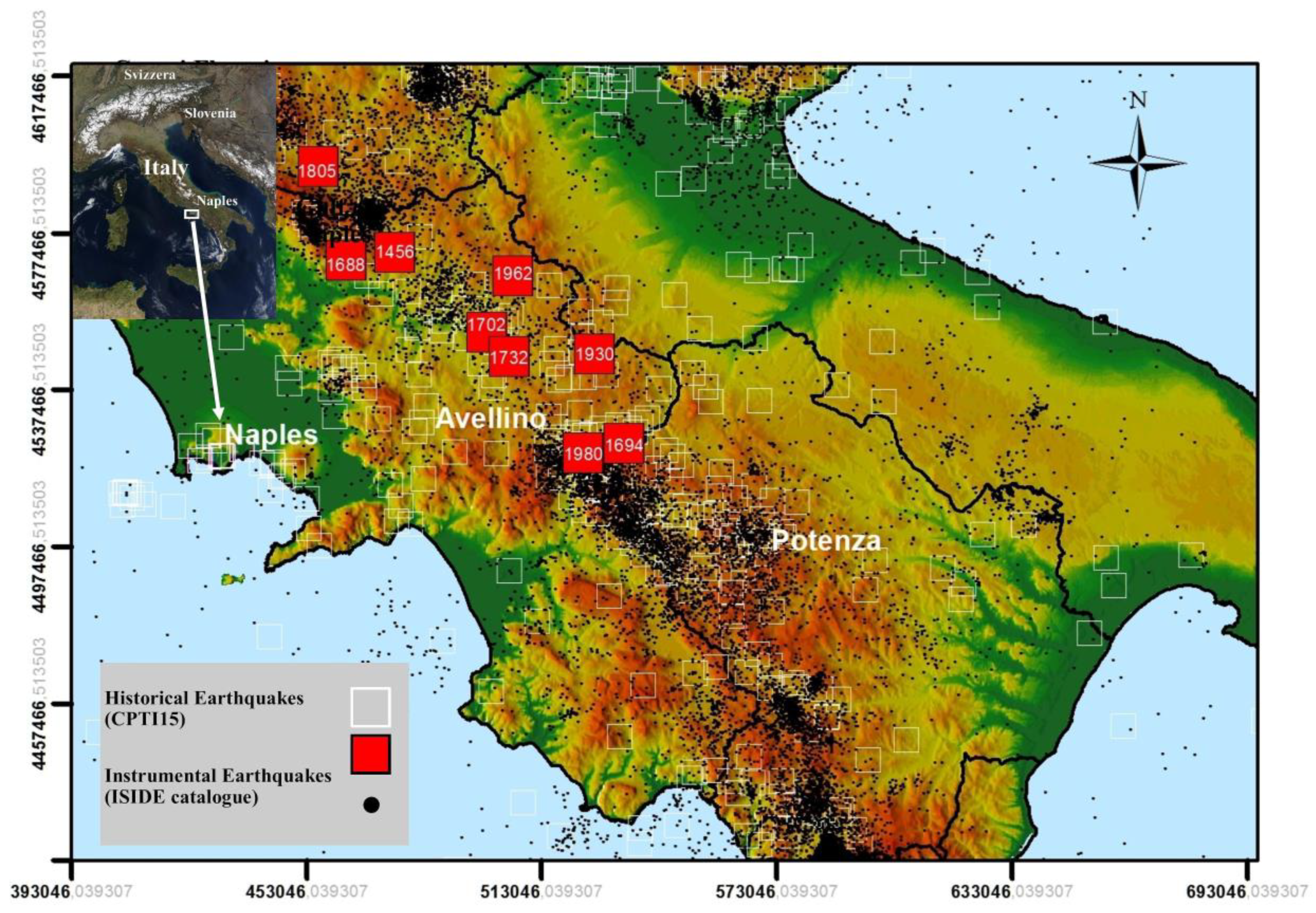
Since historical times, the central-southern Apennines chain has generated the strongest earthquakes in Italy. The epicenters of the most energetic events located along this chain have shown a significant alignment in the northwest-southeast direction, parallel to the main direction of the Apennines (
Figure 1). The city of Naples has always been exposed to strong earthquakes, and these repeatedly have hit the Southern Apennines from the 15th century to the present (
Appendix A Table A1) [
1,
2,
3,
4]. Our analysis of the available earthquake catalogues and relative scientific papers shows that more than 100 earthquakes with intensities of I > III Mercalli–Cancani–Sieberg (MCS) over the felt level hit the city of Naples in the last millennium. Ten of these events far exceeded the damage threshold, with intensities of VII MCS or greater [
5,
6,
7]. The strong historical earthquakes that have struck the city since the 15th century (
Figure 1) occurred in 1456 (I
0 = XI MCS), 1688 (I
0 = XI MCS), 1694 (I
0 = X MCS), 1702 (I
0 = X MCS), 1732 (I
0 = X-XI MCS), 1805 (I
0 = X MCS), 1930 (I
0 = X MCS), 1962 (I
0 = IX MCS) and 1980 (I
0 = X MCS) [
1,
2,
3]. Moreover, the city being located between two active volcanic districts, the Somma-Vesuvio to the East, and the Campi Flegrei volcanic field to the West, has been affected also by volcano-tectonic and volcanic earthquakes [
8,
9,
10] even if characterized by low/moderate magnitude and shallow hypocenters (
Appendix A Table A1).
Indeed, in early historical times, the most severe earthquakes to hit Naples originated from the Vesuvian area, including the 62 AD and 79 AD earthquakes [
11], which had maximum intensities up to VII–VIII MCS. Naples was also affected by the seismicity related to the eruption of Vesuvio in 1631 [
4,
12] and more recently by the 9 October 1999 earthquake (Md = 3.6 [
13]; Mw = 3.24 [
14]). Additionally, Naples suffered from the Campi Flegrei earthquakes preceding and accompanying the eruption of Monte Nuovo in 1538 [
5,
15], and more recently was affected by the 4 October 1983 earthquake (M = 4.2 [
3]) during the 1982–1984 bradyseismic crisis of Campi Flegrei.
In this paper we present an analysis of the damages that have occurred in Naples due to the strongest earthquakes located in Campania–Molise (Southern Apennines), but we do not take into account the damages of earthquakes that occurred in Vesuvio and Campi Flegrei, for which there is not as much detailed information as for the Apennines earthquakes. The aim is mainly to highlight local seismic hazards and potential heavy damage that could threaten the historical center of Naples and its rich architectural heritage. Based on the intensity and frequency of earthquakes that have occurred in the past, the city of Naples is ranked in the second seismic category, ‘average seismicity’ (Deliberazione Giunta Regionale n.5447 of 2012).The structure of this paper includes an introduction describing the most relevant seismic events that have hit the Neapolitan area, the object of the study, as well as geological structure of the city, highlighting its main characteristics and historical and architectural heritage.
Section 2 describes the methodology applied in the study, in which the levels of damage to prestigious monuments of the Naples area are determined and then compared with a density map detailing areas of similar damage.
Section 3 illustrates in detail the most important Apennines earthquakes that have hit the city of Naples, including detailed data that are collected in the
Appendix A. In
Section 4 we analyze and discuss the results of our study.
Section 5 outlines the conclusions of our analysis.
The city of Naples is located inside the Campanian Plain, a very large tectonic depression NW-SE elongated, that originated during the extensional regime following the formation of the Southern Apennines [
16,
17,
18,
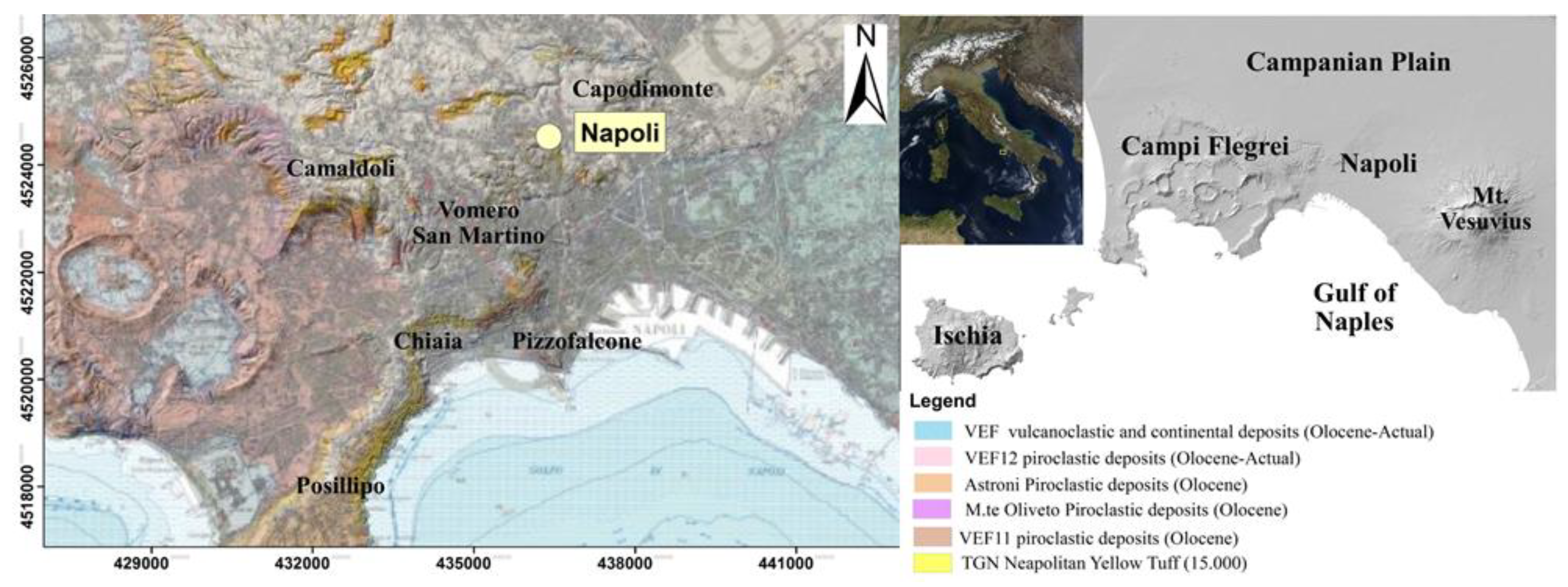
19]. The Plain includes the Campi Flegrei and Somma-Vesuvio active volcanic districts to the west and southeast of the city, respectively. In particular, the most important explosive eruptions of the Campi Flegrei volcanic field produced the Campanian Ignimbrite (
Figure 2) (Ignimbrite Campana (IC)) (39,000 years) and the Neapolitan Yellow Tuff (Tufo Giallo Napoletano (TGN)) (15,000 years) [
20] lithoid tuffs that represented the main source rocks for most of the ancient and modern buildings inside the urban area of Naples.
The main reliefs of the urbanized area of Naples include ancient eruptive centers originating the hills of Capodimonte, Vomero, Pizzofalcone, Posillipo and Camaldoli (
Figure 2). These were the results of activity from about 70 explosive monogenetic volcanoes as well as down-faulting displacement associated with the collapse of the Campi Flegrei caldera [
21,
22].
The very intense urbanization of Naples has been almost continuous over time, and architectural development and consequent anthropic activities have nowadays hidden the ancient eruptive centers, making their relative volcanic morphologies rather undetectable.
The stratigraphic setting of the urban area is very complex and mainly characterized by a cover of loose pyroclastic and reworked material lying on Neapolitan Yellow Tuff (TGN) sequence, with lateral and vertical heterogeneities due to the presence of different erupted products, and vertical and lateral variation in lithification grades [
23].
The main outcropping deposits in the urban area of Naples, as regards the areal extension, are pyroclastic ashes, lapilli and pumice dating less than 15,000 years, which therefore erupted after the TGN setting, as well as some reworked pyroclastics, as shown on the Geological Map of Naples (
Figure 2) [
24]. The litified deposits of IC and TGN very rarely outcrop inside the urban area.
As the city of Naples is located next to the western area of the Southern Apennines, it has consistently been exposed to the strong historical earthquakes that repeatedly have hit the mountain chain and its villages. Moreover, as the city is enclosed by two great active volcanic districts (i.e., the Somma-Vesuvio and Campi Flegrei volcanic fields), it has also been affected by the seismic activity (even at low/moderate magnitudes) of volcano-tectonic and volcanic earthquakes, an issue that persists to the present day [
20,
25,
26,
27]. In particular, the Campi Flegrei area, near the city, has undergone considerable deformations and almost continuous subsidence due to several bradyseismic phases over the past two millennia [
28].
Settlements in the Gulf of Naples date back to a very ancient age due to its mild climate, the fertility of its soil and its abundance of landings and natural harbors.
The city has been influenced in its urban development by the arrival of various peoples and cultures, from its Greek foundations, Roman conquest, Byzantine domination, Norman and Swabian dominations and alternating French and Spanish dynasties to the present era [
29,
30]. Such multiethnic influence has given Naples a unique reality that is rich in history and culture both in terms of its the urban layout as well as its art and traditions. The historic center of Naples represents an exclusive example of a vertical stratified city, and its architecture is based on overlapping of different architectural styles [
31]. It has been possible to reconstruct the historical events of many parts of the city with greater precision due to the numerous archaeological findings that have been found over the years. Parthenope, the first nucleus of the future Naples, was founded by the Cumans in the eighth century BC on Echia Mountain, and is presently known as Pizzofalcone [
32].
The harbor was located to the east of the city, near the present-day Municipio Square, and there Castel Nuovo (as known as Maschio Angioino) became the headquarters of the medieval age and one of the most important symbols of the city. At the beginning of the sixth century BC, the city was rebuilt as Neapolis, meaning “new city”, and was conceived similarly to the city of Cuma [
32]. Due to the privileged relationship with Athens, Naples became one of the largest ports in the Mediterranean Sea, with unchanged urban development until the middle of the first century BC [
33]. Following the influences of Athens and Syracuse, the political and social equilibrium of Naples was compromised towards the end of the fifth century BC by the expansion of the Oscii people, who conquered both the territories of the Etruscans in northern Campania and the territories of the Cumans [
32]. In 327 BC, the city of Naples was strongly contended between the Sanniti and Romans. Rome had the strongest influence, reducing the city’s Greek traditions and habits [
32]. From the first century BC until approximately the first century AD, Roman high society went to Naples for rest and recreation. It was precisely in this period that Naples was enriched with refined Roman villas. In the Augustan age, Naples was hit with the catastrophic earthquakes of 62 AD and 79 AD and the eruption of Vesuvius [
2,
34,
35].
Many churches were built during the empire of Constantine in the fourth century, such as San Giovanni Maggiore and San Giorgio Maggiore. In 533 AD, the church of Santa Maria Maggiore alla Pietrasanta was built in the historical center of Naples [
36,
37].
Naples was the attracted the attention of the Byzantine and Gothic peoples following the crisis of the Roman empire. The Byzantines conquered Naples in 534 AD, and thereafter became a Byzantine province for the next six centuries, during which the Duchy of Naples was established. Numerous monasteries were built in the city during this time, including the Greek monastery of San Sebastiano. Moreover, several churches were located on the hills of the interior or on the islands, such as the hill of Monte Echia or the islet of Megaride. Between 780 and 790 AD [
37], the Byzantine bishop Stephen II built the church of San Gaudioso [
36,
37]. In the centuries of ducal government, Naples often found itself in contrast with the Lombards and Saracens and also had to face repeated contrasts with the pontifical state. The defensive wall was enlarged to protect Naples against attacks and heavy population growth. In the 9th and 10th centuries, the churches of Santi Severino e Sossio (10th century) and Santa Maria Donnalbina were built. In 1137, the Duchy was conquered by the Normans who later formed the Kingdom of Sicily.
Guglielmo I of Sicilia was responsible for the construction of Castel Capuano (1176) and for the restoration and expansion of Castel dell’ Ovo by building the tower later known as Normandy.
After the Norman period, Naples was subjected to Swabian domination. Thanks to Federico II of Swabia, Naples regained strong central power, thanks in particular to the establishment of the first State University of History.
During the subsequent Angevin domination, Charles I and Charles II of Anjou reorganized the city of Naples, with urban planning interventions aimed at creating a port city [
38].
At the end of the 13th and beginning of the 14th centuries, numerous churches were built as a result of kings’ subsidies [
29,
30,
36,
37], including the churches of San Agrippino (1265), San Lorenzo Maggiore (1270), Santa Maria La Nova (1279), San Domenico Maggiore (1283), Sant’ Agostino Maggiore (1287) and San Pietro Martire (1294), the monastery of Santa Chiara (1310) and the Santa Maria Assunta Cathedral (1270–1313). In addition, Charles I of Anjou was responsible for the construction of a new fortress, Castel Nuovo (known as Maschio Angioino) (1279), which was located by the sea, right near the creek that previously hosted the port of Naples. The construction of the Santa Maria del Carmine church dates back to the end of the 13th century, thanks to the contributions of Roberto d’ Angio’ who donated the land in 1270, although historical sources report the date of the start of construction as the 12th century [
36,
37]. During the Angevin domination, the church of Santissima Annunziata Maggiore (1318, but completely rebuilt and enlarged in 1513), Castel Sant’Elmo (1329–1343), Certosa di San Martino (1325–1368, located at Vomero hill) and Castello del Carmine (1382) were built [
36,
37].
During the Catalan–Aragonese kingdoms (15th century), the church of Santa Maria di Monteoliveto (Sant’Anna dei Lombardi) was built (1411) and subsequently enlarged during the kingdom of Alfonso V of Aragona. He also restored Castel Nuovo, which had been damaged by continuous wars, and added an exemplary Triumph Arch and the famous throne room. Subsequently, the city of Naples underwent considerable expansion, with the construction of a new wall with 22 cylindrical towers [
36,
37]. Alfonso V of Aragona made the city of Naples a true capital of the Mediterranean [
29,
30]. During the Ferdinando kingdom, many monuments were built [
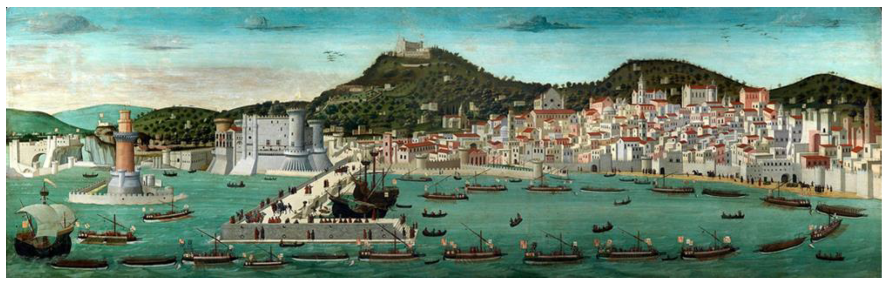
39]: Palazzo Carafa d’Andria (in the early 15th century), Porta Capuana (1484), the Como Palace (Museo Filangieri) (1464 and 1490), the Diomede Carafa Palace (1470) and the facade of the San Severino palace (about 1470) of the Salerno princes. The currently facade of the church of Gesù Nuovo was rebuilt in 1584, as well as the actual lower church of Santi Severino e Sossio (1490). The urban situation is described in detail in the Tavola Strozzi dated at the end of 15th century (
Figure 3).
Between the 16th and 17th centuries, the fortification walls were built to the south of Naples [
29,
30]. Under Spanish domination, the kingdom of Carlo V (and the regency of his viceroy Don Pedro de Toledo) subjected Naples to further transformations in which the quarters of Toledo and the present Spanish quarters were built, in order to accommodate the Spanish military garrisons. At the beginning of the 16th century further work of transformation and fortification of Castel Nuovo (Maschio Angioino) and the construction of Palazzo Pignatelli di Monteleone were made by the Bourbons. During the 16th and 17th centuries, the churches of Gesù Vecchio dell’Immacolata di Don Placido (1554), San Tommaso d’Aquino (1567 but destroyed in 1932), San Liguoro/San Gregorio Armeno (1572), San Severo out of the walls (1573), Gesù Nuovo (1584), Madonna della Pietà dei Turchini (1592), San Filippo Neri (Gerolamini) (1592), San Filippo e Giacomo (1593), San Paolo Maggiore (1538–1630), Santa Maria della Sanità or San Vincenzo (1602–1614), Santa Maria della Verità/Sant’Agostino degli Scalzi (1603), Santa Maria ai Monti (1606–1654), Santa Teresa degli Scalzi (1604), San Michele Arcangelo dei Mercedari a Port’Alba (1620), San Nicola alla Carità (1647) and la Croce di Lucca were built [
36,
37]. Construction of the Regio Arsenal dates back to 1577, but it was destroyed in the early 1900s, while the construction of Palazzo Carafa di Maddaloni is dated to 1580. In the 17th century, the Church of Santa Maria Donnalbina (ninth century) and the Church of Santa Maria Maggiore alla Pietrasanta (sixth century) were rebuilt, and in 1667 the construction of the Presidio di Pizzofalcone began. In 1600, the building of the Palazzo Reale (Royal Palace) took place [
39], and was subsequently expanded in 1734 when Naples became the capital of the kingdom with Charles III of Bourbon. The final transformations took place in Ferdinand’s time between 1838 and 1858 with a general restoration of the neoclassical style. In 1919 this was largely dedicated to the National Library, where the oldest wing was used as a Museum of Historic Property.
During the 20th century, many other changes and renovations were carried out, both in the Municipio Square and in the oldest city center [
30].
As can be seen from the synthetic historical and architectural excursus reported so far, the uniqueness of Naples and above all of its historical center stems largely from the use of the ancient Greek path of road that has been preserved to the present day. Because of this, the historic center of Naples was declared a human heritage site in 1995 by UNESCO, and was included on its list of protected properties.
Our analysis has allowed us to reconstruct the seismic history of some of the most representative urban monuments of Naples, and to perform a seismic macro-zoning of the ancient center of the city in order to reduce future seismic risk. A methodology already widely tested for assessing the damage level of some cities affected by both historical and relatively more recent earthquakes was adopted [
40,
41].
3. Historical Earthquakes of the Southern Apennines Felt in Naples
The strongest historical earthquakes to have struck the city of Naples since the beginning of the 15th century (
Figure 1) were in 1456 (I
0 = XI MCS), 1688 (I
0 = XI MCS), 1694 (I
0 = X MCS), 1702 (I
0 = X MCS), 1732 (I
0 = X-XI MCS), 1805 (I
0 = X MCS), 1930 (I
0 = X MCS), 1962 (I
0 = IX MCS) and 1980 (I
0 = X MCS) [
1,
2,
3]. Devastating effects were inflicted upon the historical Neapolitan urban area as a result of these seismic events, and damages reaching levels of up to VIII MCS have been recorded [
6,
7].
During the 20th century, the city of Naples was hit by three major earthquakes (in 1930, 1962 and 1980) originating in the Southern Apennines. The last of these events is still deeply engraved in the collective memory, due to the high number of casualties, of about 3000, and the almost complete destruction of some nearby Apennines villages.
The main seismological and macroseismic parameters of the earthquakes that hit the city of Naples in the previous centuries are listed in
Appendix A Table A1. Between 1293 and 2002, 178 recorded events hit Naples, about ninety of which had an epicentral intensity of I
0 >= VII MCS. Ten events struck Naples severely, exceeding a damage level greater than VII MCS [
6,
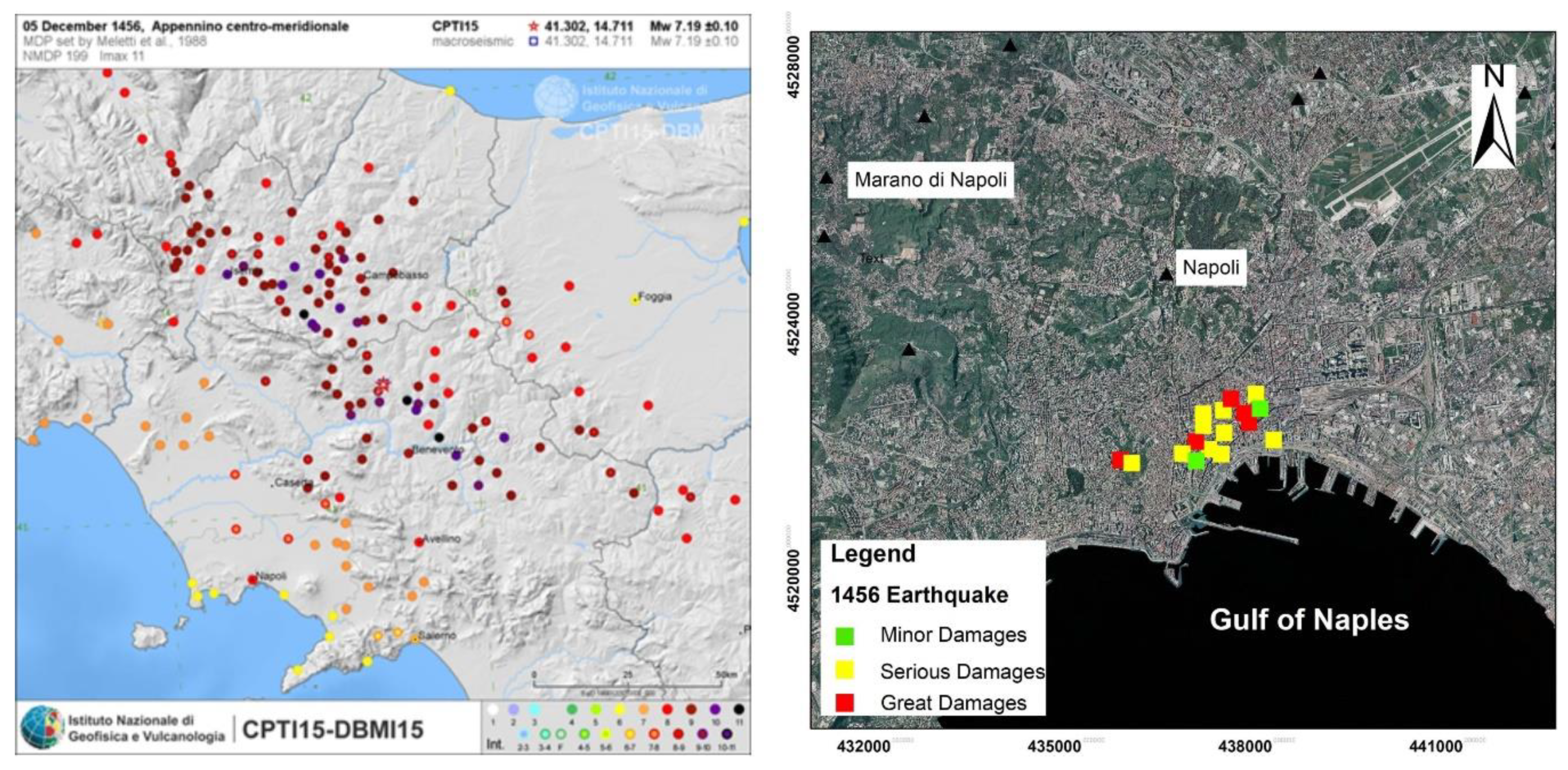
7]. The 5 December 1456 earthquake is considered one of the most catastrophic events to have occurred in Italy during historical times, and had an epicentral intensity of XI MCS and a magnitude Mw = 7.2 [
14,
42]. It was a very complex event, with five main shocks triggered along the axis of the Apennines [
47] along a narrow belt ranging from the Abruzzi to Campania regions. The seismogenic area inside Benevento province was the nearest to Naples, and caused high levels of damage. The earthquake’s destruction covered a large region (
Figure 4), with an intensity I≥ IX MCS and more than 90 localities affected in Central and Southern Italy, killing at least 60,000 people. In Naples, the earthquake resulted in 100 casualties. Damages were widespread, many buildings were damaged and streets were blocked. Historical sources report that damage occurred above all to the most important castles, fortresses, churches and monasteries of the time (
Appendix A Table A2). Great and serious damages were recorded in Naples (
Figure 4). In detail, collapses occurred in Castel Sant’Elmo, Castel Capuano and the churches of San Agostino, San Pietro Martire, San Lorenzo, Santa Chiara, San Giovanni Maggiore, Santa Maria Maggiore alla Pietrasanta, San Domenico and San Severino. Moreover, even the bell towers of San Agrippino and the Cathedral fell down; the Certosas of San Martino and Monte Oliveto monasteries, located outside the walls, were severely damage (
Appendix A Table A2). The severity of the impact in the city of Naples was estimated to be equal to VIII MCS [
5,
42,
47].
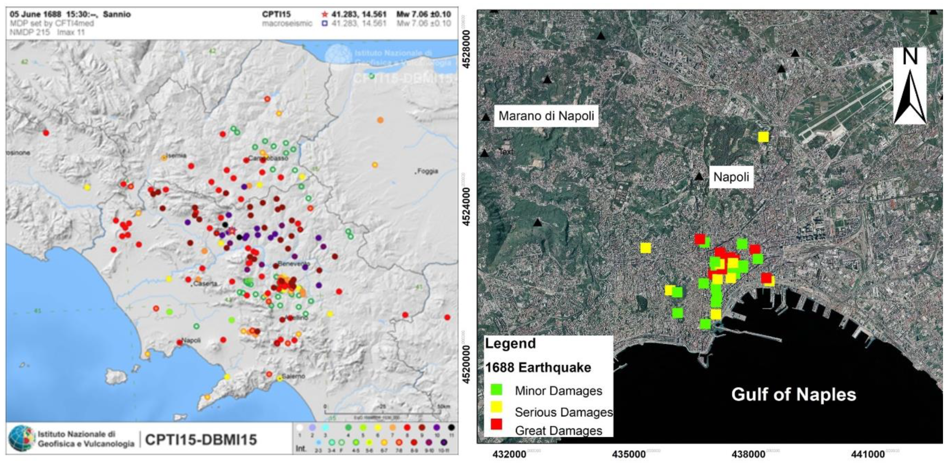
Another devastating earthquake that affected the whole Campania region occurred on 5 June 1688, with its epicenter inside the Sannio area (
Figure 5). This earthquake was characterized by an epicentral intensity of I
0 = XI MCS, presumably in the Cerreto Sannita and Civitella Licinio villages, and a value of magnitude Mw = 7.06 and I
0 = X on the basis of the Environmental Seismic Intensity (ESI-07) scale [
48]. The earthquake resulted in a high number of casualties, with some chronicles reporting as many as 10,000 deaths. Moreover, many environmental effects such as fractures, landslides, liquefaction phenomena and hydrological variations were observed that in some cases, together with the diffuse damage to the housing stock, led to total relocation of some Apennines villages like Cerreto Sannita [
6,
48]. The level of damage was very high throughout Naples (
Figure 5), with a number of deaths somewhere between 35 and 50 people. Chronicles have reported severe and widespread damage, especially to the churches of the city (
Appendix A Table A3). Of the church of San Paolo, an anonymous contemporary source reported that “in the atrium below the Church of San Paolo dei Teatini … the magnificent arch has dropped together with the large and ancient columns, which they were said to form the famous temple of Castor and Pollux, only four left standing, but almost falling, so far 19 people have been quarried from ruin”.
The collapse of the frames of some private buildings and damages to Castel Sant’Elmo, Castel Capuano, Castel Nuovo, the fortress of Torrione del Carmine, the Sala del Tesoro and the Royal Palace also occurred. The last revision proposed by the authors of DBMI15 [
1] assigned a VIII MCS to Naples.
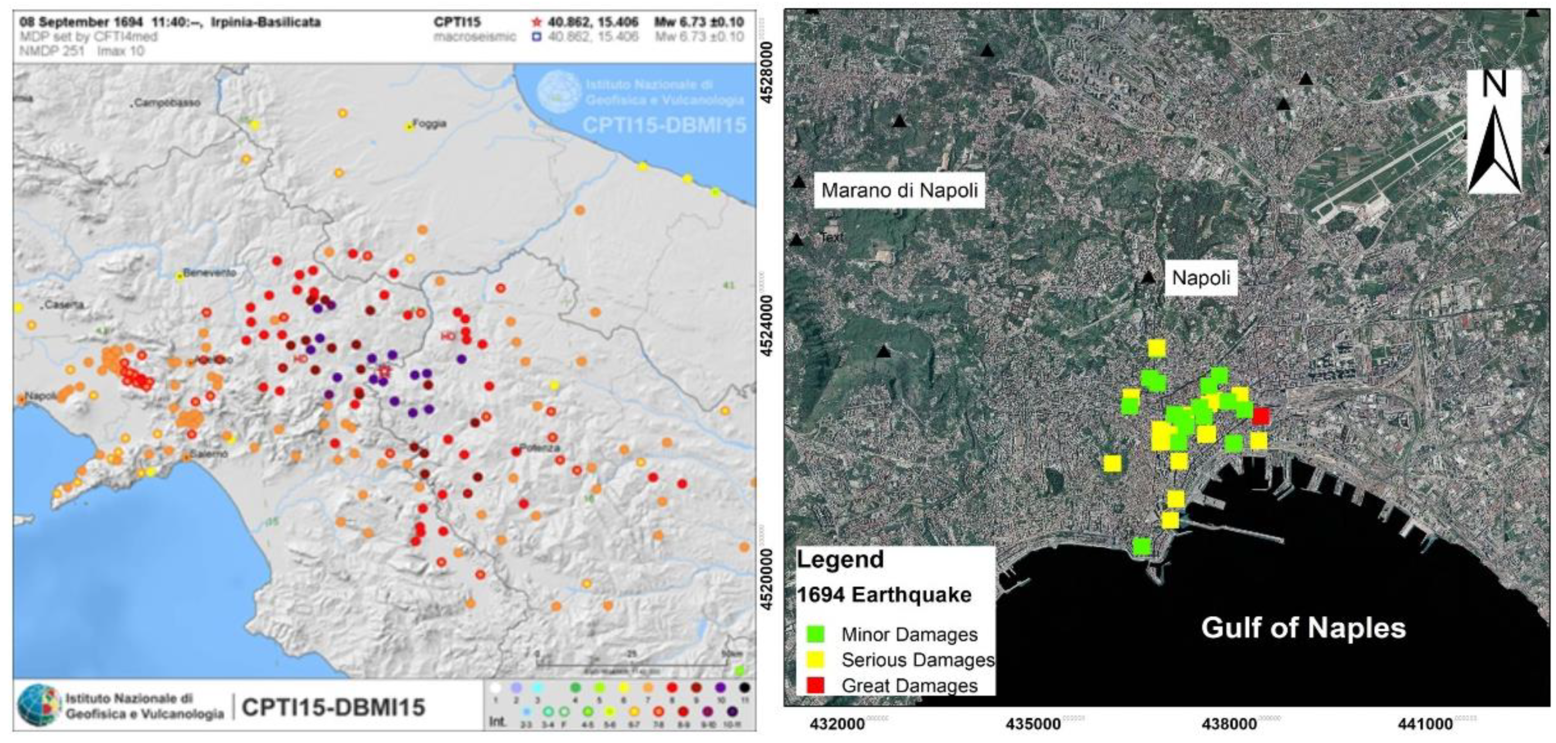
On 8 September 1694, a strong earthquake struck a wide area of Southern Italy between the Campania and Basilicata regions. Unlike the 1456 and 1688 earthquakes, the epicentral area was located between Irpinia and Basilicata (
Figure 6), with I
0 = X MCS, Mw = 6.73 and I
0 = X ESI-07 [
43,
48,
49]. The seismogenic source located in Campania and Basilicata, relatively more distant than the source zones of the 1456 and 1688 earthquakes, caused a lower damage level in Naples (
Figure 6), evaluated as VII MCS. The number of deaths was considerable, about 6000 in total, although only one dead and one wounded were reported in Naples. The earthquake caused moderate damage throughout the Neapolitan urban fabric, with only a single collapse at Porta Nolana. Widespread damage occurred to the ecclesiastical buildings (
Appendix A Table A4), and more or less serious damages occurred to the Cathedral and the churches of Girolamini, Santa Maria Maggiore, San Paolo Maggiore dei Teatini, Santi Severino e Sossio churches, among others. Much damage to public buildings was observed, including to Castel Nuovo (Maschio Angioino) and Castel Capuano. In the Royal Arsenal, seven arches and its central pillars lanes were damaged, while the Real Presidio of Pizzofalcone, which was already undergoing repairs, suffered damage to some walls that had to be reinforced with iron chains. Moreover, the noble palaces of the Duke Carafa of Maddaloni, the Duke Carafa of Andria and of the Duke Pignatelli of Monteleone suffered considerable damage.
In the following century, the city of Naples was hit by two strong events that took place on 14 March 1702 and 29 November 1732; both these epicenters were located between the Irpinia and Sannio areas, with damage levels evaluated to have an intensities of VI and VII MCS, respectively.
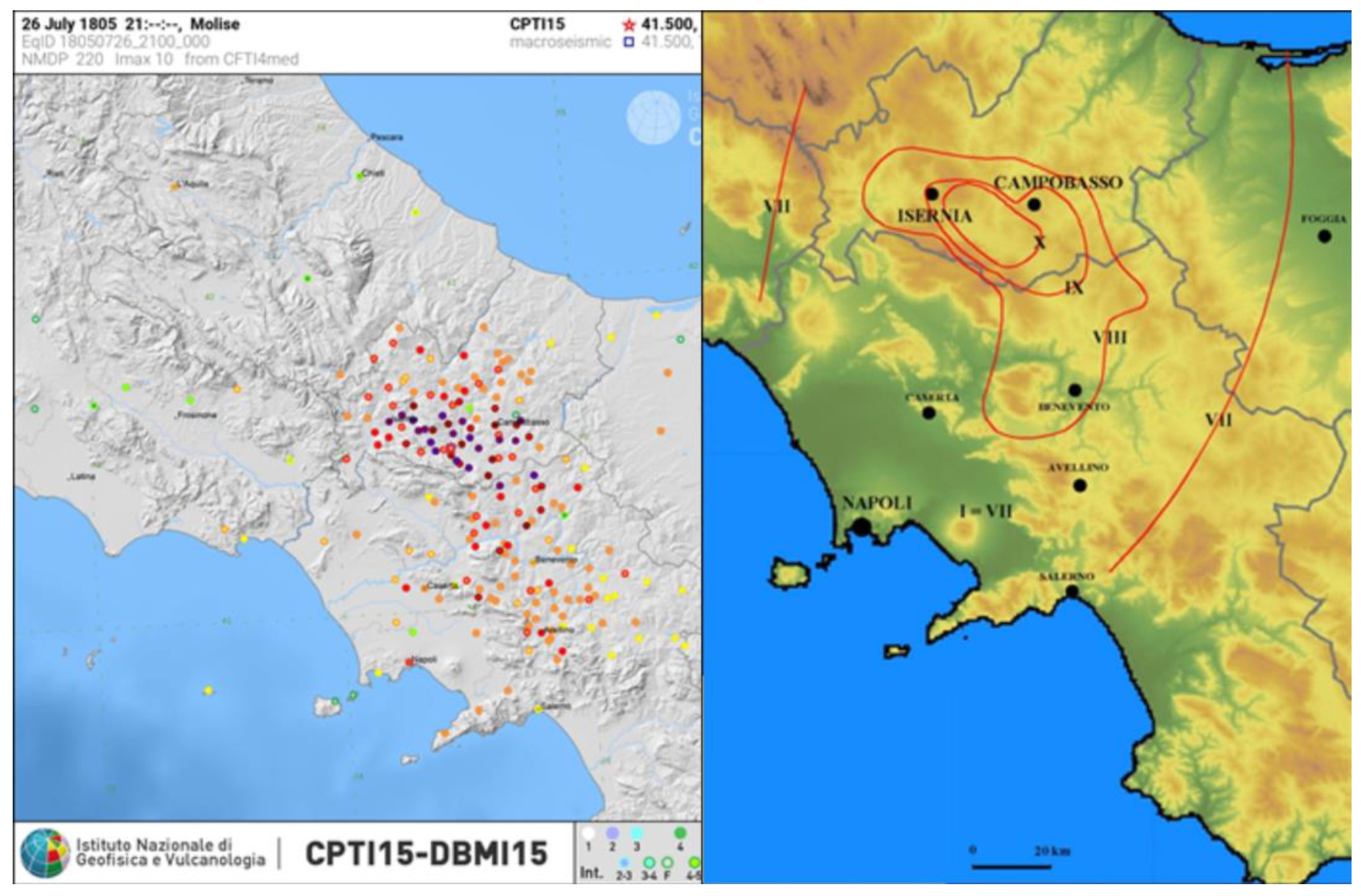
The 26 July 1805 earthquake is also known as “the earthquake of Sant’Anna”, since it occurred on the day dedicated to celebrating this saint. The epicentral area was located in the Molise region (
Figure 7), where at least 19 villages suffered almost complete destruction, with epicentral intensity I
0 = X MCS, Mw = 6.73 and I
0 = X ESI-07 (
Figure 7) [
48,
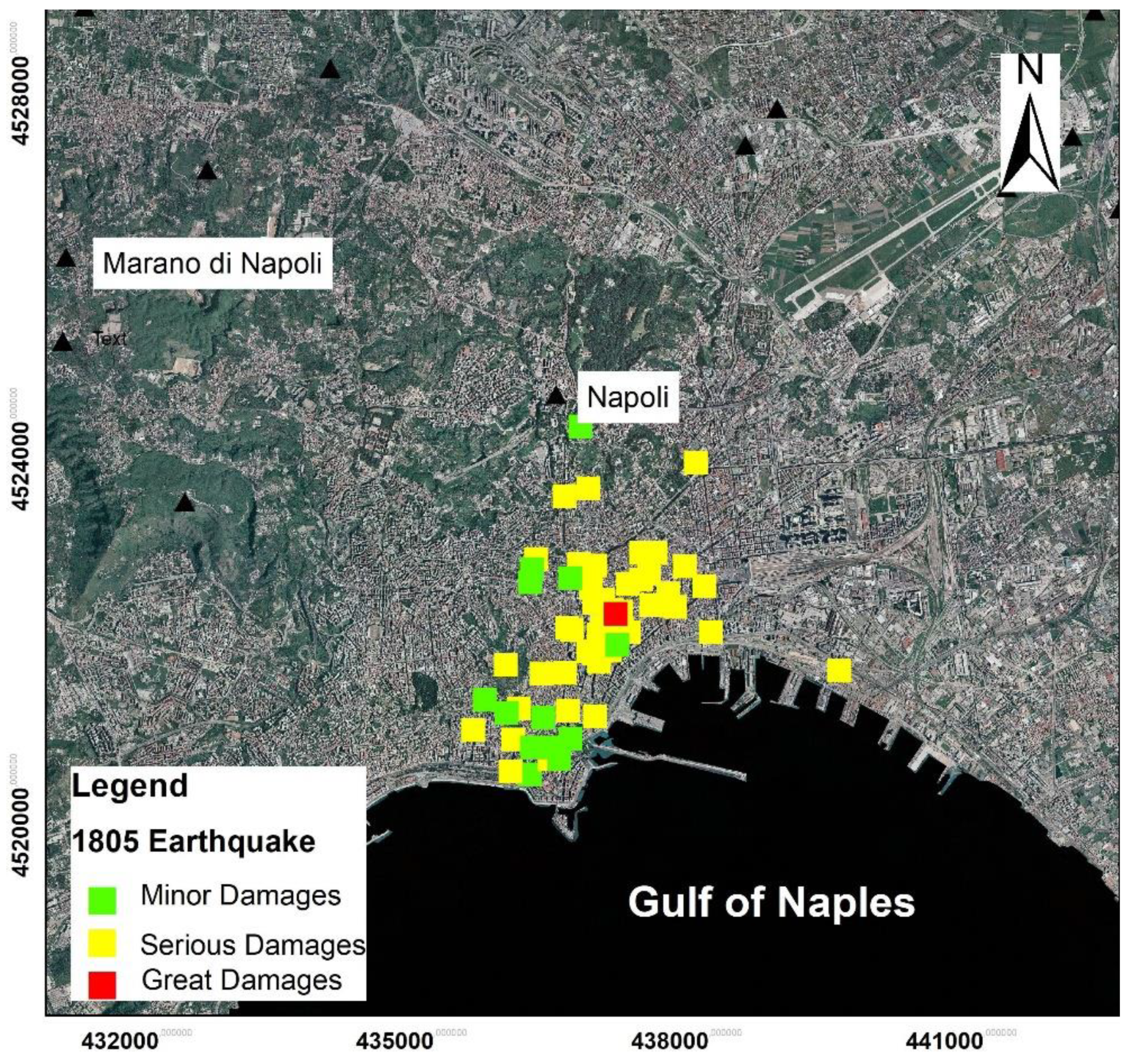
50]. According to official chronicles, 5573 people died and 1583 were injured. There was widespread damage in Naples (
Figure 8), with collapses and deep fractures requiring shoring of housing. The damage level was equal to VII–VIII MCS (
Appendix A Table A1). The major damages were related to part of today’s historical center (
Appendix A Table A5) [
44]. Indeed, Castel Nuovo (Maschio Angioino), the big building of Regj Studj, the Reale Albergo de’ Poveri, the Gesù Vecchio Church and the buildings of the Prince of Angri, of Roccella, of Sangro, of Duca della Regina and many others over the district of Pizzofalcone suffered serious damage. Moreover, some churches like the Cathedral, Sant’Agostino alla Zecca and San Demetrio also suffered severe damages. The strong earthquake produced many environmental effects throughout the whole area hit by the quake, especially in the epicentral area of the Bojano plain, with surface faulting, fractures, landslides and hydrological variations. In the Bay of Naples and along the coastal areas of Gaeta (in Latium) and Sorrento peninsula (in Campania), located very far from the epicentral area, changes in sea level equivalent to a low-energy tsunami were observed [
45,
48,
50,
51].
In the 20th century, three catastrophic earthquakes with I0 ≥ IX MCS occurred in one of the main seismogenic zones located in the Southern Apennines. Events on 23 July 1930 and 21 August 1962 occurred in Irpinia; the earthquake of 23 November 1980 occurred at the border between Irpinia and Basilicata.
The 1930 earthquake struck the Campania, Puglia and Basilicata regions. The epicentral area was located between the northern Irpinia and Puglia regions, with I
0 = X MCS, 6.67 M
w and I
0 = X ESI-07 scale [
14,
48,
51,
52,
53,
54]. The most damaged villages were located along the axis of the Apennines Chain, including Ariano Irpino, Lacedonia, Villanova del Battista, Scampitella, Trevico and Aquilonia, with values of I = IX-X MCS. The earthquake led to the deaths of 1424 people, with 4624 injured and about 100,000 being left homeless in the aftermath.
In Naples, widespread damage occurred to housing stock and, in particular, four houses in the Courts area collapsed as well as the Casanova Bridge, with four casualties. The intensity value in Naples was VII MCS.
On 21 August 1962, a violent earthquake of Mw = 6.15 struck Campania, on the border between the Sannio and Irpinia regions, with an epicentral intensity of IX MCS [
14,
55]. The most affected towns were Ariano Irpino, Casalbore, Melito Irpino and Montecalvo Irpino in the province of Avellino; and Apice, Ginestra degli Schiavoni, Molinara, Reino and San Giorgio la Molara in the province of Benevento. The event was characterized by some premonitory shocks that deterred people from staying inside of their homes, ultimately reducing the number of deaths to only 17.
In the city of Naples, the earthquake resulted in five deaths, only one of which was a direct consequence of collapse. Moreover, there were collapses in the gutters of some buildings and serious damage to the Duca D’Aosta and Thaon de Revel dam, as well as to the Calata Villa del Popolo and Vittorio Veneto docks. Minor damages were widely observed in the historical center, and in the Vomero hilly zone. The intensity values assigned to Naples were VI–VII MCS.
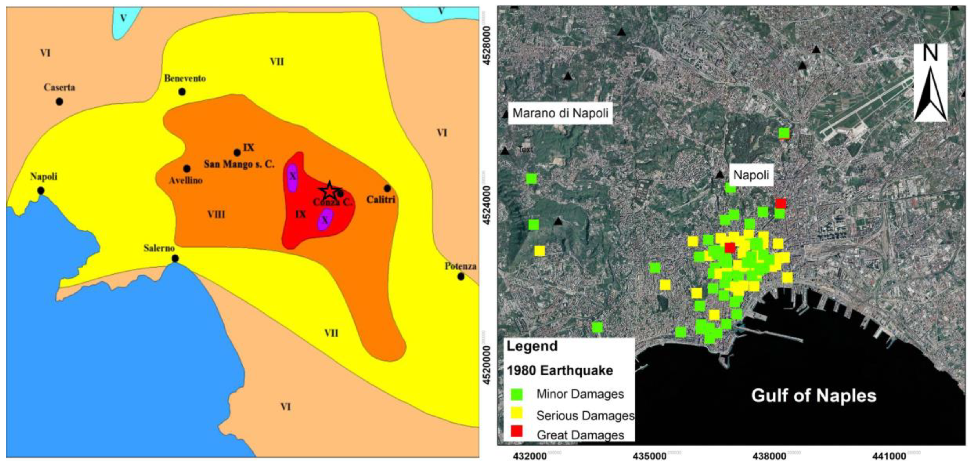
The final catastrophic event to devastate Southern Italy over the past 100 years is known as the Irpinia-Lucania earthquake, and it occurred on 23 November 1980 (
Figure 1). It was characterized by an I
0 = X MCS (
Figure 9), Mw = 6.9 and I = X ESI [
14,
48,
56]. It was felt throughout Italy, from southern Sicily in the South, to Emilia Romagna and Liguria in the North, with the epicenter between the Campania and Basilicata regions, which were the most damaged regions. The number of destroyed homes was 75,000, while about 275,000 were seriously damaged. The earthquake led to a loss of nearly 3000 lives and damage to about 800 villages. Castel Nuovo di Conza, Conza della Campania, Lioni, Santomenna, San Mango sul Calore, San Michele di Serino and Sant’Angelo dei Lombardi were almost completely destroyed. In Naples, this event produced widespread and serious damages (
Figure 9), reaching an intensity of VII MCS [
56]. About 18,000 stability analyses were carried out throughout the city, equal to 80–85% of the entire housing stock. The most damaged areas were found in the old city (
Appendix A Table A6) [
5,
6,
7,
56,
57,
58].
A residential tower collapsed in the Poggioreale area, where 52 people were killed. Among the most important monumental buildings seriously damaged by the earthquake was the Reale Albergo dei Poveri (one of the largest in Europe), where the infirmary, part of the refectory and some of the surrounding rooms on the first and second floor collapsed [
56].
4. Results and Discussion
The strongest earthquakes of the Southern Apennines, such as those in 1456 (Imax = XI MCS, Mw = 7.2), 1688 (Imax = X MCS, Mw = 6.7) and 1805 (Imax = X MCS, Mw = 6.7), reached Naples at a maximum macroseismic intensity of I = VIII on the MCS scale, with considerable damage to the architectural heritage of the historical center specifically, as in the case of Castel Nuovo, as well as to to the ecclesiastical heritage more generally. Meanwhile, the earthquakes of 8 September 1694, 23 July 1930 and 23 November 1980 caused a lower damage level of VII MCS in the urban area of Naples (
Appendix A Table A1).
We distinguished the levels of damage relative to historical earthquakes as belonging to three different classes of damage: minor damage (MD), serious damage (SD) and great damage/collapse (GD). In detail, the levels of damage of the 1456 and 1688 earthquakes were great and serious, concentrated in a very restricted area of the historical center of Naples (
Figure 4 and
Figure 5, respectively). The 1805 earthquake resulted in a serious level of damage spread over a wider area of the historical center of the city (
Figure 8), while the 1980 earthquake produced a serious level of damage that was widespread (
Figure 9) in the historical center but also included minor damage diffused in the suburban areas (
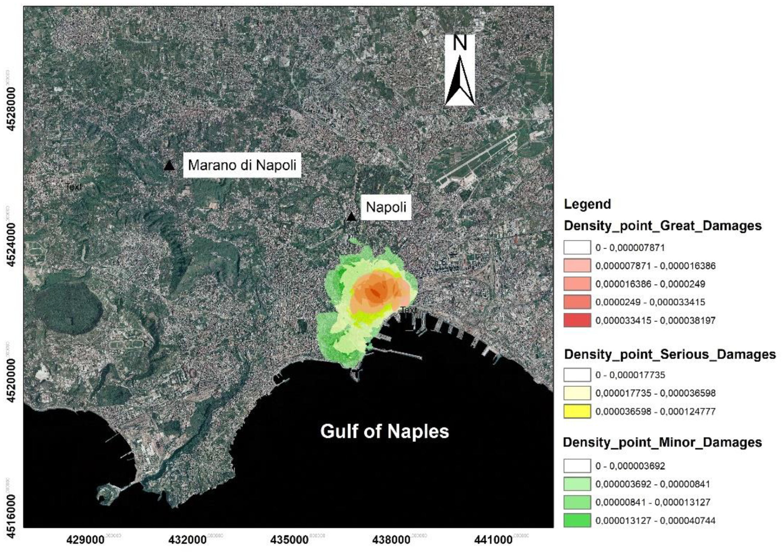
Figure 9). According to the different effects that the earthquakes had on the historical buildings of Naples, an original damage-density map has been elaborated upon in this paper (
Figure 10), synthesizing all of the damage data on the architectural heritage that were collected ad hoc for comparison in our study.
Figure 10 shows the way in which the damage repeats and overlaps in the same areas, with the greatest damages in the historic center of Naples covering an area of 17 km
2 and representing the most vulnerable portion of the city.
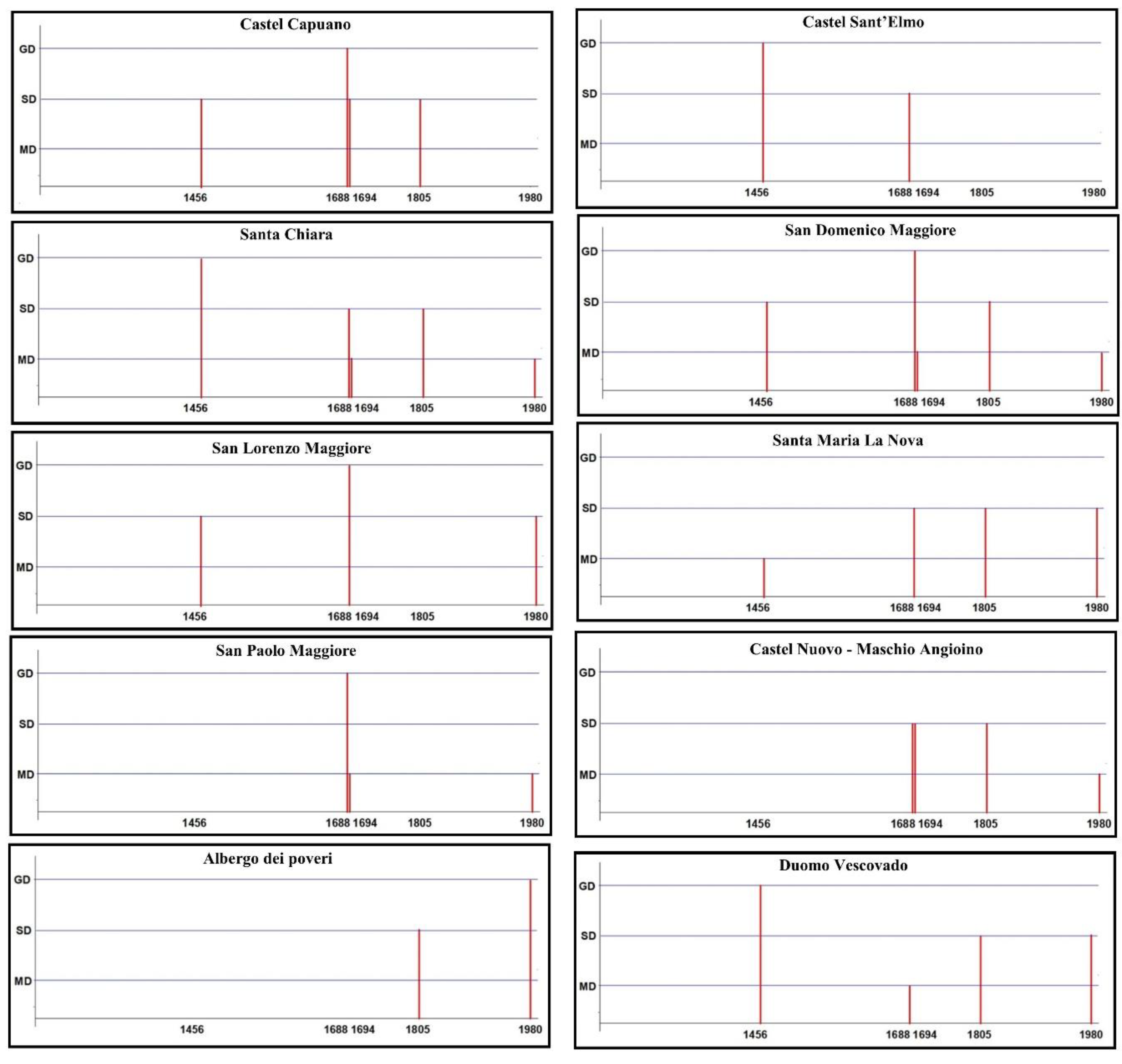
Several pieces of the most famous Neapolitan architectural heritage are located in this area, including the castles/fortresses of Castel Capuano, Castel Nuovo (Maschio Angioino) and Castel Sant’Elmo, and the churches of the Cathedral, Santa Chiara, San Domenico Maggiore, San Lorenzo Maggiore, Santa Maria La Nova, San Paolo Maggiore and the Albergo dei Poveri, all of which suffered the greatest damages s a result of historical earthquakes (
Figure 11). In detail, among the castles/fortresses of medieval age between the 11th and 13th centuries, Castel Sant’Elmo is the one that reported the greatest damage due to the earthquake of 1456, while Castel Capuano suffered the most significant damage from the earthquake of 1688. Moreover, Castel Capuano was the most affected by all of the historical earthquakes generally, as it suffered serious damages following the 1456, 1694 and 1805 earthquakes. Castel Nuovo (Maschio Angioino) was seriously damaged by the seismic events of 1688, 1694 and 1805.
Considering the damage suffered by the churches, we observed that the Duomo (13th century), Santa Chiara (14th century), San Domenico Maggiore (13th century), San Lorenzo Maggiore (13th century), Santa Maria La Nova (13th century) and San Paolo Maggiore (16th century) churches suffered damage from almost all of the strong earthquakes under consideration (
Figure 11). The Church of San Paolo Maggiore suffered great damage following the earthquake of 1688 and minor damage following the earthquake of 1694. The historical monumental building of the Albergo dei Poveri, among the largest buildings in Europe (18th century), showed a different damage compared to the churches and castles/fortresses as it had severe damage only resulting from the 1805 earthquake, and partial collapses due to the 1980 seismic event.
Our study shows that the vulnerability of buildings repeatedly damaged by earthquakes depends on very complex factors that go beyond the magnitude of the earthquakes themselves, the distance from the epicenter and the condition of the building, but also the geological substrate on which they were built, which in some cases can amplify the shaking due to the earthquake [
5,
23,
59,
60].
From this perspective, the seismic history of the recent past teaches us that other major events could also occur in the future and affect the city of Naples and its historical heritage again. Therefore, the “prevention” and preservation of architectural heritage appears to be the correct solution, together with respect for the regulations surrounding the construction of buildings in seismic zones. Accordingly, it is necessary to think about the methods of intervention, especially to reduce the risk of damage and/or the collapse of historical and monumental buildings. Therefore, a collective effort involving interdisciplinary action could address administrations and demand that they take prompt actions in order to protect the historical center of Naples, which was declared a World Heritage Site by UNESCO in 1995: “… considering that the site is of exceptional value. It is one of the most ancient cities in Europe, whose contemporary urban fabric preserves the elements of its long and eventful history. Its setting on the Bay of Naples gives it an outstanding universal value which has had a profound influence in many parts of Europe and beyond”.

 ,
, 

