Improving Accuracy of Impervious Surface Extraction Based on a Threshold Hierarchical Method (THM)


Abstract
:1. Introduction
2. Materials and Study Area
2.1. Study Area
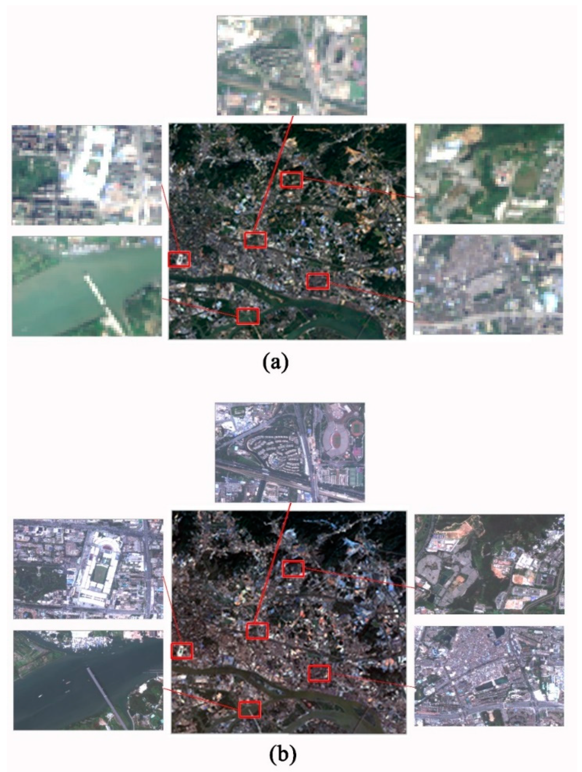
2.2. Study Data
2.3. Test Samples
2.4. Data Processing
3. Methods
3.1. THM
3.2. LSMA
3.3. OOM
3.4. Accuracy Assessment
4. Results
4.1. Outcome of the LSMA
4.2. Range of Different Thresholds
4.3. Range of Different Thresholds
- (1)
- The RMSE at different thresholds obtained through the THM showed a “U” trend. The RMSE was 0.2019 at a threshold of 0.1, and 0.2203 at a threshold of 1.0; the RMSE was the smallest (0.1871) at a threshold of 0.5.
- (2)
- The THM is suitable for improving the accuracy in extracting impervious surfaces. The RMSE value was smaller than that obtained by the LSMA, which was 0.2107 at a threshold of <0.9.
- (3)
- The optimal threshold was 0.5. As compared to the LSMA, the precision of the THM, considering the optical threshold, could be increased by 3.83%.
5. Discussion
6. Conclusions
Author Contributions
Funding
Acknowledgments
Conflicts of Interest
References
- Weng, Q. Remote sensing of impervious surfaces in the urban areas: Requirements, methods, and trends. Remote Sens. Environ. 2012, 117, 34–49. [Google Scholar] [CrossRef]
- Lu, D.; Li, G.; Kuang, W.; Moran, E. Methods to extract impervious surface areas from satellite images. Int. J. Digit. Earth 2013, 7, 93–112. [Google Scholar] [CrossRef]
- Arnold, C.L., Jr.; Gibbons, C.J. Impervious Surface Coverage: The Emergence of a Key Environmental Indicator. J. Am. Plan. Assoc. 1996, 62, 243–258. [Google Scholar] [CrossRef]
- Lu, D.; Weng, Q. Extraction of urban impervious surfaces from an IKONOS image. Int. J. Remote Sens. 2009, 30, 1297–1311. [Google Scholar] [CrossRef]
- Wu, C. Quantifying high-resolution impervious surfaces using spectral mixture analysis. Int. J. Remote Sens. 2009, 30, 2915–2932. [Google Scholar] [CrossRef]
- Weng, Q.; Hu, X.; Lu, D. Extracting impervious surfaces from medium spatial resolution multispectral and hyperspectral imagery: A comparison. Int. J. Remote Sens. 2008, 29, 3209–3232. [Google Scholar] [CrossRef]
- Wu, C.; Murray, A.T. Estimating impervious surface distribution by spectral mixture analysis. Remote Sens. Environ. 2003, 84, 493–505. [Google Scholar] [CrossRef]
- Fang, H.; Wei, Y.; Dai, Q. A Novel Remote Sensing Index for Extracting Impervious Surface Distribution from Landsat 8 OLI Imagery. Appl. Sci. 2019, 9, 2631. [Google Scholar] [CrossRef] [Green Version]
- Elvidge, C.D.; Tuttle, B.T.; Sutton, P.C.; Baugh, K.E.; Howard, A.T.; Milesi, C.; Bhaduri, B.L.; Nemani, R. Global Distribution and Density of Constructed Impervious Surfaces. Sensors 2007, 7, 1962–1979. [Google Scholar] [CrossRef]
- Liu, X.; Hu, G.; Ai, B.; Li, X.; Shi, Q. A Normalized Urban Areas Composite Index (NUACI) Based on Combination of DMSP-OLS and MODIS for Mapping Impervious Surface Area. Remote Sens. 2015, 7, 17168–17189. [Google Scholar] [CrossRef] [Green Version]
- Yang, Y.; He, C.; Zhang, Q.; Han, L.; Du, S. Timely and accurate national-scale mapping of urban land in China using Defense Meteorological Satellite Program’s Operational Linescan System nighttime stable light data. J. Appl. Remote Sens. 2013, 7, 073535. [Google Scholar] [CrossRef]
- Deng, Y.; Fan, F.; Chen, R. Extraction and Analysis of Impervious Surfaces Based on a Spectral Un-Mixing Method Using Pearl River Delta of China Landsat TM/ETM+ Imagery from 1998 to 2008. Sensors 2012, 12, 1846–1862. [Google Scholar] [CrossRef] [PubMed] [Green Version]
- Fan, F.; Deng, Y.; Zhu, Y. Extracting impervious surface area and discussing urban expansion of Guangzhou (1990–2003) based on V-I-S model by using linear spectral mixture analysis method. J. Food Agric. Environ. 2013, 11, 925–929. [Google Scholar]
- Lu, D.; Moran, E.; Hetrick, S. Detection of impervious surface change with multitemporal Landsat images in an urban–rural frontier. ISPRS J. Photogramm. Remote Sens. 2011, 66, 298–306. [Google Scholar] [CrossRef] [PubMed] [Green Version]
- Liu, J.; Liu, C.; Feng, Q.; Ma, Y. Subpixel impervious surface estimation in the Nansi Lake Basin using random forest regression combined with GF-5 hyperspectral data. J. Appl. Remote Sens. 2020, 14, 034515. [Google Scholar] [CrossRef]
- Dams, J.; Dujardin, J.; Reggers, R.; Bashir, I.; Canters, F.; Batelaan, O. Mapping impervious surface change from remote sensing for hydrological modeling. J. Hydrol. 2013, 485, 84–95. [Google Scholar] [CrossRef]
- Jacobson, C. Identification and quantification of the hydrological impacts of imperviousness in urban catchments: A review. J. Environ. Manag. 2011, 92, 1438–1448. [Google Scholar] [CrossRef]
- Imhoff, M.L.; Zhang, P.; Wolfe, R.E.; Bounoua, L. Remote sensing of the urban heat island effect across biomes in the continental USA. Remote Sens. Environ. 2010, 114, 504–513. [Google Scholar] [CrossRef] [Green Version]
- Yuan, F.; Bauer, M.E. Comparison of impervious surface area and normalized difference vegetation index as indicators of surface urban heat island effects in Landsat imagery. Remote Sens. Environ. 2007, 106, 375–386. [Google Scholar] [CrossRef]
- Lu, D.; Weng, Q. Use of impervious surface in urban land-use classification. Remote Sens. Environ. 2006, 102, 146–160. [Google Scholar] [CrossRef]
- Alberti, M.; Booth, D.; Hill, K.; Coburn, B.; Avolio, C.; Coe, S.; Spirandelli, D. The impact of urban patterns on aquatic ecosystems: An empirical analysis in Puget lowland sub-basins. Landsc. Urban Plan. 2007, 80, 345–361. [Google Scholar] [CrossRef]
- Brabec, E.; Schulte, S.; Richards, P.L. Impervious Surfaces and Water Quality: A Review of Current Literature and Its Implications for Watershed Planning. J. Plan. Lit. 2002, 16, 499–514. [Google Scholar] [CrossRef]
- Liu, Z.; Wang, Y.; Li, Z.; Peng, J. Impervious surface impact on water quality in the process of rapid urbanization in Shenzhen, China. Environ. Earth Sci. 2012, 68, 2365–2373. [Google Scholar] [CrossRef]
- Xian, G. Satellite remotely-sensed land surface parameters and their climatic effects for three metropolitan regions. Adv. Space Res. 2008, 41, 1861–1869. [Google Scholar] [CrossRef]
- Ridd, M.K. Exploring a V-I-S (vegetation-impervious surface-soil) model for urban ecosystem analysis through remote sensing: Comparative anatomy for cities†. Int. J. Remote Sens. 1995, 16, 2165–2185. [Google Scholar] [CrossRef]
- Lu, D.; Weng, Q. Spectral Mixture Analysis of the Urban Landscape in Indianapolis with Landsat ETM+ Imagery. Photogramm. Eng. Remote Sens. 2004, 70, 1053–1062. [Google Scholar] [CrossRef]
- Wu, C. Normalized spectral mixture analysis for monitoring urban composition using ETM+ imagery. Remote Sens. Environ. 2004, 93, 480–492. [Google Scholar] [CrossRef]
- Lu, D.; Weng, Q.; Li, G. Residential population estimation using a remote sensing derived impervious surface approach. Int. J. Remote Sens. 2006, 27, 3553–3570. [Google Scholar] [CrossRef]
- Lu, D.; Hetrick, S.; Moran, E. Impervious surface mapping with Quickbird imagery. Int. J. Remote Sens. 2011, 32, 2519–2533. [Google Scholar] [CrossRef] [Green Version]
- Fan, F.; Fan, W.; Weng, Q. Improving Urban Impervious Surface Mapping by Linear Spectral Mixture Analysis and Using Spectral Indices. Can. J. Remote Sens. 2015, 41, 577–586. [Google Scholar] [CrossRef]
- Benz, U.C.; Hofmann, P.; Willhauck, G.; Lingenfelder, I.; Heynen, M. Multi-resolution, object-oriented fuzzy analysis of remote sensing data for GIS-ready information. ISPRS J. Photogramm. Remote Sens. 2004, 58, 239–258. [Google Scholar] [CrossRef]
- Van de Voorde, T.; De Genst, W.; Canters, F.; Stephenne, N. Extraction of land use/land cover related information from very high resolution data in urban and suburban areas. In Remote Sensing in Transition; IOS Press: Amsterdam, The Netherlands, 2003; pp. 2–5. [Google Scholar]
- Li, W.; Ouyang, Z.-Y.; Zhou, W.; Chen, Q. Effects of spatial resolution of remotely sensed data on estimating urban impervious surfaces. J. Environ. Sci. 2011, 23, 1375–1383. [Google Scholar] [CrossRef]
- Burnett, C.; Blaschke, T. A multi-scale segmentation/object relationship modelling methodology for landscape analysis. Ecol. Model. 2003, 168, 233–249. [Google Scholar] [CrossRef]
- Kuang, W. New Evidences on Anomalous Phenomenon of Buildings in Regulating Urban Climate from Observations in Beijing, China. Earth Space Sci. 2019, 6, 861–872. [Google Scholar] [CrossRef] [Green Version]
- Sharma, D.; Singhai, J. An Object-Based Shadow Detection Method for Building Delineation in High-Resolution Satellite Images. PFG J. Photogramm. Remote Sens. Geoinf. Sci. 2019, 87, 103–118. [Google Scholar] [CrossRef]
- Liu, Y.; Wei, Y.; Tao, S.; Dai, Q.; Wang, W.; Wu, M. Object-oriented detection of building shadow in TripleSat-2 remote sensing imagery. J. Appl. Remote Sens. 2020, 14, 036508. [Google Scholar] [CrossRef]
- Sun, G.; Huang, H.; Weng, Q.; Zhang, A.; Jia, X.; Ren, J.; Sun, L.; Chen, X. Combinational shadow index for building shadow extraction in urban areas from Sentinel-2A MSI imagery. Int. J. Appl. Earth Obs. Geoinf. 2019, 78, 53–65. [Google Scholar] [CrossRef]
- Gao, X.; Zheng, X.; Shen, D.; Yang, Y.; Zhang, J. Automatic Building Extraction Based on Shadow Analysis from High Resolution Images in Suburb Areas. Geomat. Inf. Sci. Wuhan Univ. 2017, 42, 1350–1357. [Google Scholar] [CrossRef]


| Image Type | Sensor Type | Resolution | Longitude/Latitude | Acquire Time |
|---|---|---|---|---|
| Landsat 8 | OLI | 30 m | E 113.5/N 23.1 | 16 November 2014 |
| GF-2 | PMS1 | 4 m | E 113.5/N 23.1 | 13 January 2015 |
| PAN | 1 m |
| Level | Target | Segmentation Scale | Shape | Color | Compactness | Smooth |
|---|---|---|---|---|---|---|
| Level 1 | Water | 180 | 0.4 | 0.6 | 0.6 | 0.4 |
| Level 2 | Vegetation | 100 | 0.2 | 0.8 | 0.6 | 0.4 |
| Level 3 | Road | 50 | 0.7 | 0.3 | 0.4 | 0.6 |
| Level 4 | Building, Bare soil | 20 | 0.4 | 0.6 | 0.4 | 0.6 |
| RMSE | THM | LSMA |
|---|---|---|
| (a) | 0.1347 | 0.1514 |
| (b) | 0.1904 | 0.1782 |
| (c) | 0.3225 | 0.2597 |
| (d) | 0.1927 | 0.2355 |
| 0.1 | 0.2 | 0.3 | 0.4 | 0.5 | 0.6 | 0.7 | 0.8 | 0.9 | 1.0 | |
|---|---|---|---|---|---|---|---|---|---|---|
| Panchromatic GF-2 | 0.2082 | 0.1988 | 0.1940 | 0.1987 | 0.2003 | 0.2087 | 0.2121 | 0.2159 | 0.2205 | 0.2249 |
| GF-2 | 0.2019 | 0.1981 | 0.1936 | 0.1992 | 0.1871 | 0.1878 | 0.1893 | 0.2044 | 0.2107 | 0.2203 |
| GF-1 | 0.2910 | 0.2780 | 0.2591 | 0.2422 | 0.2212 | 0.1987 | 0.2115 | 0.2197 | 0.2253 | 0.2254 |
Publisher’s Note: MDPI stays neutral with regard to jurisdictional claims in published maps and institutional affiliations. |
© 2020 by the authors. Licensee MDPI, Basel, Switzerland. This article is an open access article distributed under the terms and conditions of the Creative Commons Attribution (CC BY) license (http://creativecommons.org/licenses/by/4.0/).
Share and Cite
Sun, C.; Chen, H.; Fan, F. Improving Accuracy of Impervious Surface Extraction Based on a Threshold Hierarchical Method (THM). Appl. Sci. 2020, 10, 8409. https://doi.org/10.3390/app10238409
Sun C, Chen H, Fan F. Improving Accuracy of Impervious Surface Extraction Based on a Threshold Hierarchical Method (THM). Applied Sciences. 2020; 10(23):8409. https://doi.org/10.3390/app10238409
Chicago/Turabian StyleSun, Caige, Hao Chen, and Fenglei Fan. 2020. "Improving Accuracy of Impervious Surface Extraction Based on a Threshold Hierarchical Method (THM)" Applied Sciences 10, no. 23: 8409. https://doi.org/10.3390/app10238409