Article

Change in Sediment Provenance on the Inner Slope of the Chukchi Rise and Their Paleoenvironmental Implications

1
Department of Geology, Research Institute of Natural Science, Gyeongsang National University, Jinju 52828, Korea
2
Korea Polar Research Institute (KOPRI), Incheon 21990, Korea
*
Author to whom correspondence should be addressed.
Appl. Sci. 2021, 11(14), 6491; https://doi.org/10.3390/app11146491
Submission received: 16 June 2021 / Revised: 10 July 2021 / Accepted: 12 July 2021 / Published: 14 July 2021
(This article belongs to the Special Issue Research on Clay Minerals)

Abstract

:
The Arctic Ocean is one of the world’s most remarkable regions with respect to global climate change. The core ARA09C-St03 was analyzed for mineral composition and Nd isotope to determine the sediment provenance and reconstruct the paleoenvironment in the inner slope of the Chukchi Rise. Core ARA09C-St03 represents overall cycles of brown and gray color with three distinct dark brown layers and two pinkish-white layers and is divided into eight sedimentary units based on the lithological feature. The core has a continuous record of the late marine isotope stage (MIS) 5 to the Holocene and in particular provides a particularly high-resolution record from the Last Glacial Maximum (LGM). Sediment is derived mainly from the adjacent East Siberian Sea and the North American region, and changes in sediment provenance are controlled by climate-dependent particle size. During the glacial/stadial periods, sediments in Units 3, 5, and 8 were supplied by the East Siberian Sea via meltwater-derived suspension. The major ice-rafted debris (IRD) events in Units 2, 4, and 7, characterized by abundant dolomite and K/C ratio, were sourced from North America. The North America-derived materials reflect the initiation and disintegration of the Laurentide Ice Sheet and icebergs transported them across the open Arctic Ocean. The differences in provenance within these periods may be related to the scale of the Laurentide Ice Sheet. Interglacial sediments, including those from Units 1 and 6, are of mixed origin from Eurasia and the Canadian Archipelago and may have been transported by oceanic current and seasonal sea ice. These periods are likely associated with the negative Arctic Oscillation (AO) intensifying the Beaufort Gyre.

1. Introduction

The Arctic Ocean is the smallest of the world’s oceans, with a surface area of 9.5 × 10⁶ km2 (2.6% of the world’s ocean) [1]; however, it is one of the most remarkable regions with respect to global climate change. The Arctic Ocean influences the global climate mainly through seasonal or permanent sea ice cover and deep-water formation controlling oceanic thermohaline circulation [2]. Climate change in the Arctic Ocean represents an amplified signal of global change [2,3], and paleoenvironmental research can yield important insights into the mechanisms of climate change and thus predict future changes in the climate system.
The Arctic Ocean is a unique sea with surrounding continental shelves that make up 52.7% of the Arctic Ocean’s surface area [4]. It is surrounded by the continents of Eurasia and North America and is divided into the western and eastern Arctic by the Lomonosov Ridge. The western Arctic Ocean includes several seas (the Beaufort, Chukchi, and East Siberian Seas) and basins (the Amerasian, Chukchi, and Makarov Basins). The Bering Strait also connects the Arctic Ocean to the Pacific Ocean with a depth of 50 m.
Provenance studies provide information on oceanic circulation patterns and clues to the interpretation of the sedimentary environment. Abundant terrigenous material is supplied annually by rivers (227 × 106 t/y) and coastal erosion (~430 × 106 t/y) from the surrounding continents [5,6]. The Arctic Ocean is additionally characterized by permanent sea ice cover, which causes low biological production compared to other oceans [7,8]. Thus, the sediments in the Arctic are mainly composed of terrigenous materials from the surrounding land masses, and the mineral assemblages are very useful for identifying source areas.
Terrigenous materials from surrounding continents can be transported by oceanic currents, sea ice, and icebergs, depending on the marine environment in the Arctic Ocean; thus, identification of source areas of terrigenous sediments provides important information on the transporting pathway and the surface circulation patterns [8,9,10,11]. The Arctic’s surface ocean circulation consists of two circulation systems, the Beaufort Gyre (BG) and the Transpolar Draft (TPD), which are regulated by Arctic Oscillation (AO) as shown in Figure 1 [11,12,13,14]. In addition, coastal currents flow in the Beaufort Sea and Siberian Sea and are met by some inflows through the Bering Strait [15,16,17]. Clay minerals are very fine-grained and can thus be transported over long distances by ocean currents. Coarser particles can only be transported to sites far from the source area by sea ice or icebergs. In particular, IRD coarser than 250 μm is generally believed to be transported exclusively by icebergs [8,10,18].
Discrimination of sediment sources and reconstruction of paleoenvironmental changes can be undertaken based on grain size, mineralogy, and elemental signals. In particular, clay mineralogy and geochemistry have been utilized as powerful tools with which to trace the provenance of terrigenous portions of marine sediments. Several provenance studies have been performed in the Arctic Ocean, using clay mineralogy [19,20,21], bulk mineralogy [8,9,10,22,23], Fe-oxide grains [11,14], and geochemical signals [24,25]. These studies have suggested that the Eurasian and North American continents were the major sediment sources in the western Arctic [8,9,10,21,22,23]. Because these source areas have different rocks and tectonics, it is easy to identify their provenance through mineralogy and radiogenic isotopes.
Distribution of various terrigenous components in the Arctic sediment records conveys information on sediment sources and depositional environments and thus paleocirculation and changes in paleoclimate conditions, such as connection to other oceans and build-up/disintegration of ice sheets [9,14,25,26]. The Chukchi Rise to Chukchi Basin areas are a sensitive region not only for oceanic currents such as Beaufort Gyre and coastal currents but also for the development of ice sheets, and thus these areas can provide useful records for understanding the evolution of ice and current patterns. However, previous studies in this area have mainly focused on the sedimentation patterns and marine environment [9,21,23,27] and have not dealt with detailed sediment provenance changes. Furthermore, the sediment cores in the Chukchi Basin have limited records during the MIS 2 due to low sedimentation rate [9,23,27].
In this study, the core ARA09C-St03 on the inner slope of the Chukchi Rise is used to provide a continuous sedimentary record containing the MIS 2 period (Figure 2). We analyzed the bulk and clay mineral compositions and Nd isotope of the sediment core for the identification of sediment provenance. The main objectives are to reconstruct the paleoenvironmental change including the sediment transport mechanisms and oceanic currents based on the determined sediment provenance in the inner slope of the Chukchi Rise.

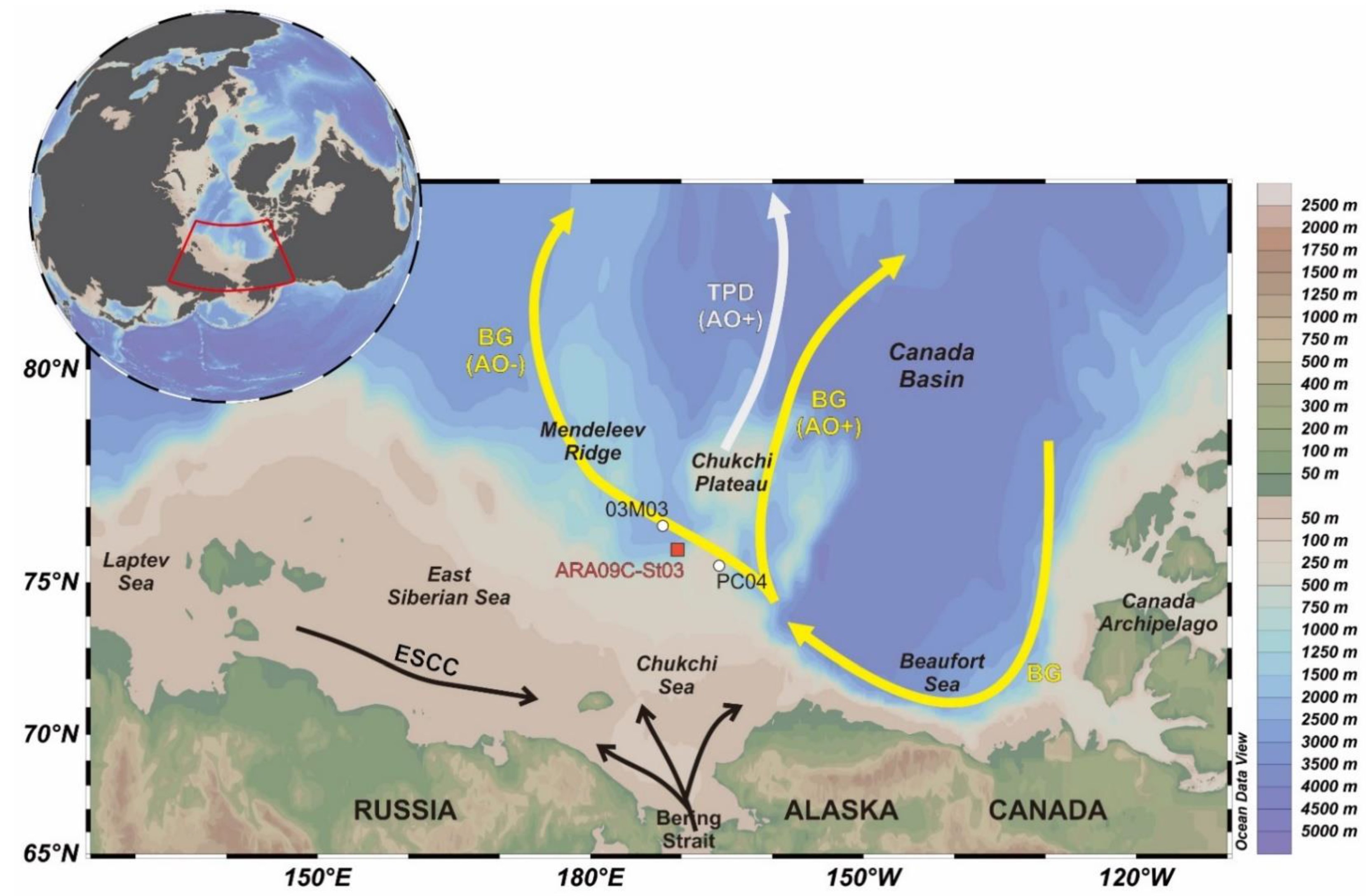
2. Materials and Methods
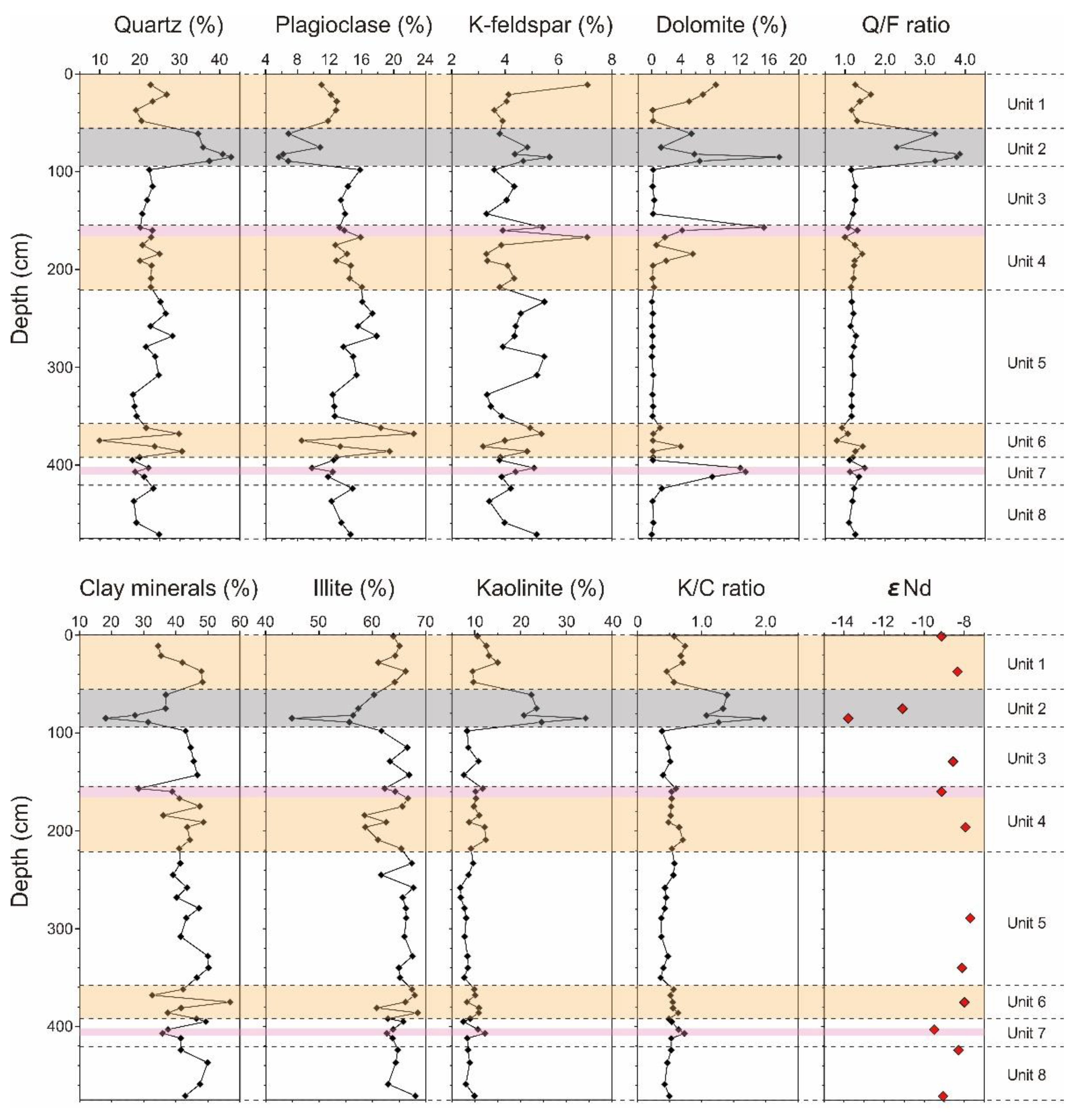
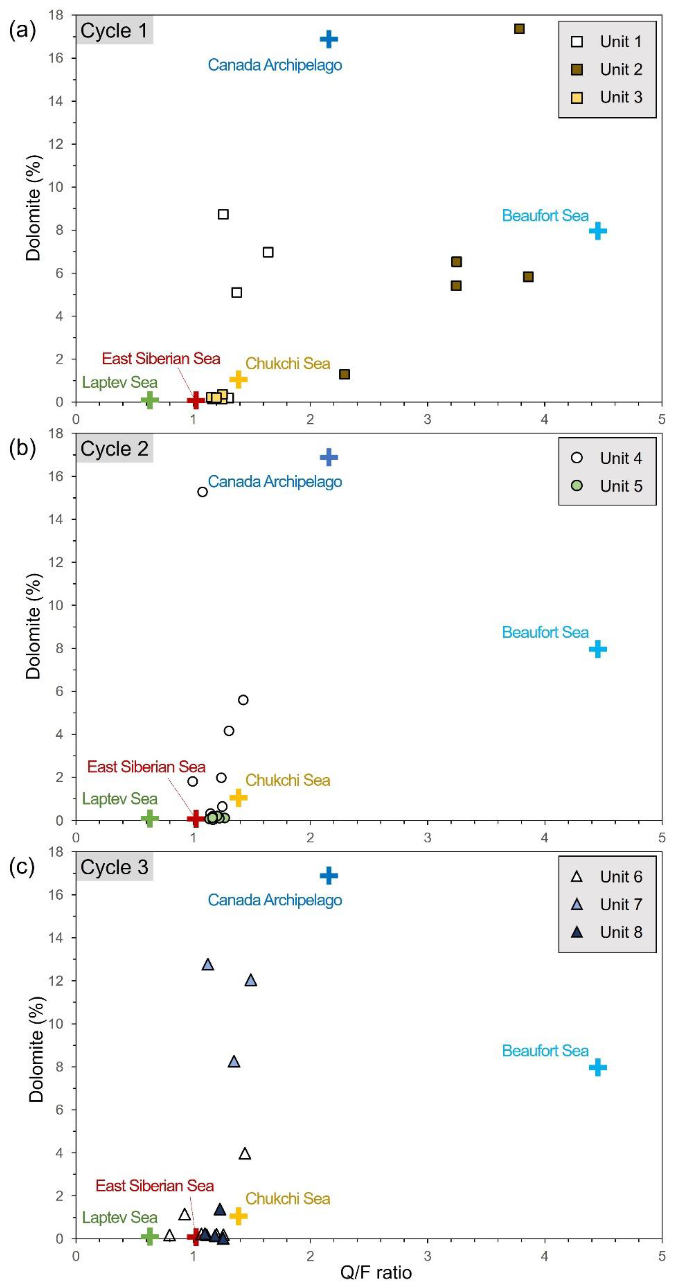
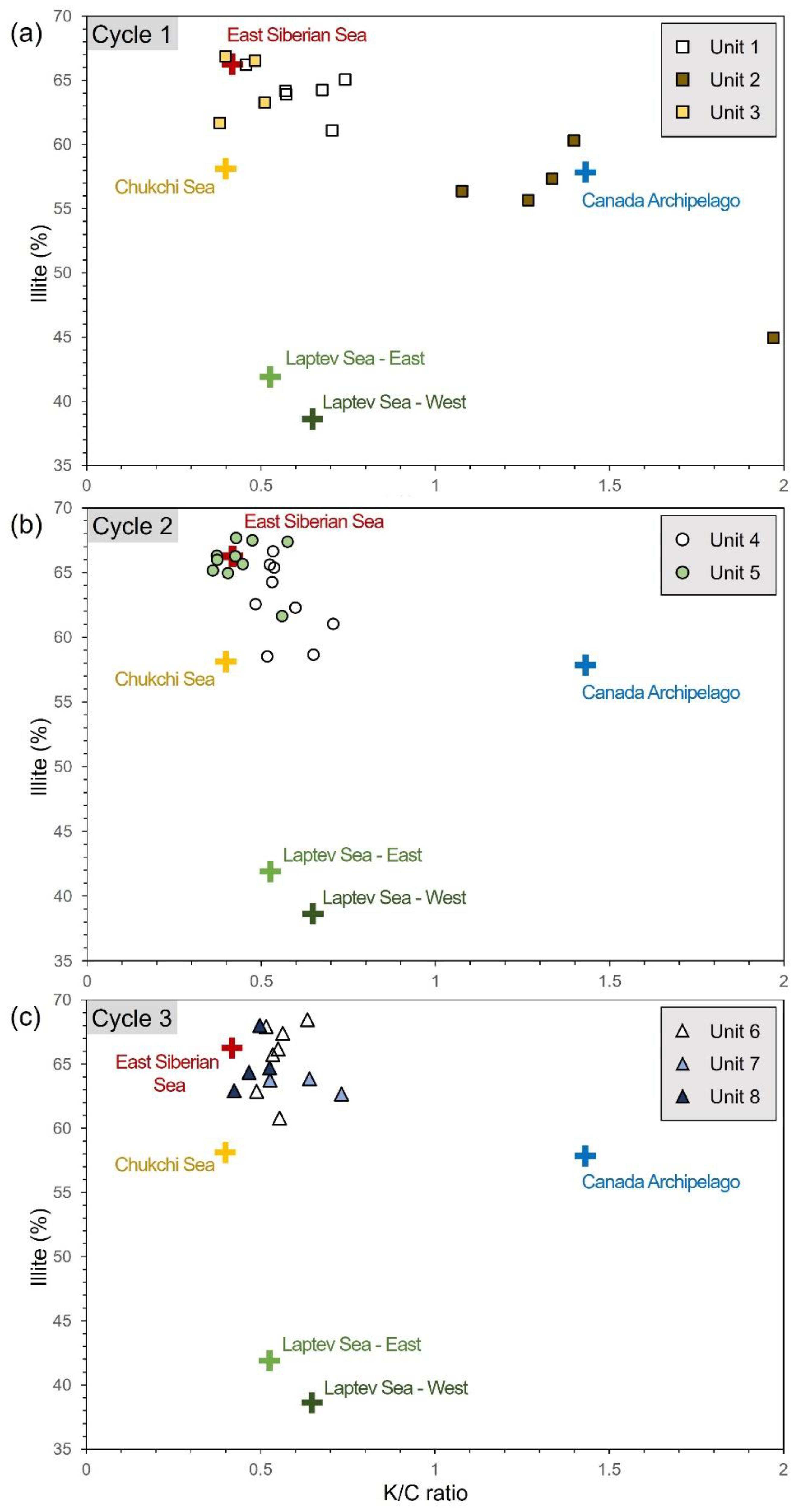
Gravity core ARA09C-St03 (475 cm long, 75.9174° N, 170.31887° W) was collected from the slope of the Chukchi Rise at a water depth of approximately 820 m by R/V ARAON of KOPRI during the ARA09C cruise in 2018. The cores were subsampled at intervals of approximately 10 cm for mineralogical and Nd isotope analyses.
For bulk sediment mineralogy, subsamples were dried and crushed using a ball mill, and then 4 g aliquot from the homogenized material. X-ray diffraction analysis was performed using a D8 Advanced A25/Bruker at the Department of Geology at Gyeongsang National University, and the analysis conditions were set to 40 Kv/40 mA, a step size of 0.02° 2θ in the range of 4–70° 2θ and a counting time of 0.4 s per step. Quantitative analysis of bulk minerals was performed using TOPAS software. The weighted profile R-factor (Rwp) was 20 or less, and the goodness of fit (GOF) was 3 or less to ensure adequate reliability.
Clay mineral compositions were obtained using semi-quantitative results of oriented samples separated into <2 µm particles. The organic matter of bulk sediment was removed using a 6% hydrogen peroxide (H2O2) solution. After they were sieved through a 63 µm mesh, the clay particles were extracted using a settling technique based on Stoke’s Law. To optimize the orientation of the specimens for XRD analyses, lumps of clay were smeared onto glass slides to minimize the grain-size effect. To identify each clay mineral, oriented samples were taken from both air-dried and ethylene glycol (EG)-treated samples. Relative abundances of four major clay minerals—illite, smectite, kaolinite, and chlorite—were estimated using a semi-quantitative calculation [28], which was used to weight integrated peak areas of characteristic basal reflections in the glycolated state using Eva 3.0 software with the empirical factor.
Sand portions (>64 μm) were calculated as a weight ratio using the weight of particles separated through sieving for the 4 g of dried subsamples. Particles >250 μm were counted by separating through a 250 µm mesh sieve. The micronodules in the separated IRD particles were analyzed for verification based on chemical composition using a field-emission electron probe micro analyzer (FE-EPMA), JXA-8530F PLUS/JEOL at Gyeongsang National University’s Center of Research Facilities. Energy-dispersive spectroscopy (EDS) patterns and backscatter electron (BSE) images were obtained under the conditions of 15 keV, 10 nA, and a beam diameter of 5–10 μm.
Fourteen clay fraction samples were selected for Nd isotopic analysis. 143Nd/144Nd analysis, including chemical separation and multicollector thermal ionization mass spectrometry (VG54–30, Isoprobe-T) analyses, were performed at the Korea Basic Science Institute. To correct isotope fractionation during the analysis, Nd isotope ratio was normalized to 146Nd/144Nd = 0.7219 [29]. Analysis of the Nd standard JNdi-1 resulted in 143Nd/144Nd = 0.512115 ± 6. For convenience, the εNd parameter was calculated using a 143Nd/144Nd value of 0.512638 for the Chondritic Uniform Reservoir (εNd = [(143Nd/144Nd)/0.512638 − 1] × 104).

3. Results

Previous studies found repeated cycles of brown and gray units and interbedded IRD-rich layers in numerous cores in the Arctic [2,4,8,20,22,26]. The brown units are typically interpreted to reflect interglacial/interstadial environments with high primary productivity [2,9]. In contrast, grayish units reflect the substantial reduction of biomass in glacial/stadial environments [2,9]. In addition, IRD events may be caused by freely circulating icebergs [8,23], and they have been reported as a feature of the deglacial period in the Chukchi Rise [21].
In Figure 2, Core ARA09C-St03 was divided into eight sedimentary units of three cycles based on the lithology such as sediment color, grain size, and IRD content. Each cycle contained one brown and one gray unit, and if the independent IRD-rich layer could be identified, it was classified as a separate unit. The sand content varies between 0% and 23.8%, with > 5% intervals at 61–89, 157–184, and 403–407 cm depth, which are associated with the IRD-rich layer.
In the first cycle, Unit 1 (0 to 50 cm) consists mainly of brown sediment, including a surficial dark brown layer (B1). This unit contains a small amount of sand (max. 3.2%) and bioturbation. Unit 2 (50–93 cm) is dark gray and contains a significant amount of IRD and sand content (max. 23.4%), while Unit 3 (93–155 cm) is gray to yellowish-gray with fine-grained mud.
The second cycle consists of Units 4 and 5. Unit 4′s sediment (155–221 cm) is generally brown in color; however, it is characterized by relatively abundant IRD and sand content with PW layer (max. 19.4%). In addition, micronodules were found below the B2 layer and were identified through the chemical composition. Micronodules accounted for a significant proportion of the IRD particles. Unit 5 (221–332 cm) consists of a yellowish-gray to gray layer with fine-grained mud.
The last cycle was divided into three units. Unit 6 (332–391 cm) sediment has a yellowish-gray to dark brown layer (B3). Unit 7 is generally gray in color and is classified as relatively abundant IRD and sand contents (max. 11.5%). Unit 8 is homogenous fine-grained gray mud.
The mineral assemblage in samples from core ARA09C-St03 mainly consists of quartz, plagioclase, alkali feldspar, mica, dolomite, calcite, and clay minerals along with other minor minerals, such as halite, pyroxene, amphibole, and Fe-oxide minerals (hematite, magnetite, and maghemite). The vertical bulk mineralogy of core ARA09C-St03 is plotted in Figure 3. Quartz, the most abundant mineral in the sediment, averaged 23.9% (9.9–42.8%), and this mineral has the highest value in Unit 2 with abundant coarse particles as shown in Table 1. Plagioclase averaged 13.3% (5.6–22.5%), showing a particularly low amount in Unit 2. Carbonate minerals, such as dolomite and calcite, were generally abundant in the IRD-rich layers, including the PW layers, showing up to 17.4% and 4.3%, respectively. K-feldspar ranged from 3.2 to 7.1% (mean 4.3%), with the most abundant samples, similar to the depth of the dolomite peaks.
The relative compositions of clay minerals are summarized in Table 2. The four clay minerals were dominated by illite (44.9–68.5%), followed by chlorite (14.1–21.8%), kaolinite (14.1–34.2%), and smectite (0.3–14.3%). Illite is the lowest in Unit 2 and also shows slightly lower values in Units 4 and 6–8. Kaolinite generally fluctuates between 14.1 and 15.0 but shows high values in Unit 2 up to 34.2%. Chlorite and smectite generally show opposite trends in the lower part of the core sediment. The εNd values of the separated clay fraction are from −13.8 to −5.4 (mean −8.9) in Table 3. Overall, they are between −7.7 and −9.5, and the lowest value is located in Unit 2.

4. Discussion

4.1. Age Assignment

Marine sediments in the Arctic Ocean, including records of paleoenvironmental change, have been studied for the purpose of reconstructing sedimentary environments using lithological, geochemical, mineralogical, and biological techniques [9,21,23,27]. These various studies provide a correlation between the chronology and sediment characteristics of the core sediments in the western Arctic during the glacial/stadial and interglacial/interstadial periods of the Quaternary period [27]. In general, core sediments in the western Arctic Ocean exhibit distinct cycles in sediment color and composition, expressed as brown and gray mud and the presence of coarse grain content in several layers [2,8,27]. Brown-colored sediments form due to the increased supply of organic matter and large amounts of Mn flux from the continents in response to warmer climates; thus, brown units in Quaternary Arctic Ocean sediments are commonly interglacial or major interstadial deposits [30,31]. These brown units exhibited generally high Mn content and biogenic carbonate with a vigorously bioturbated nature and sometimes included micronodules [21,23,27]. By contrast, glacial sediments appear gray to dark gray due to a decrease in Mn supply [21,23,27]. In addition, correlation tie points are provided by rare or unique events, such as abundant ice-rafted debris (IRD), and the PW layer expressed prominent detrital carbonate peaks [21,23,27].
Age assignment of ARA09C-St03 was established by comparing the lithological description, IRD content, and carbonate mineral contents with surrounding cores [21,23] for which age had been established (Figure 2 and Figure 3). The surficial brown B1 layer (0–5 cm) indicates the Holocene, which is corroborated by numerous AMS 14C dates typically showing the age of 10–12 ka at its base in sediment cores from various regions of the Arctic Ocean [27]. The subsequent brown B2 layer (180 to 190 cm) is AMS 14C/AAR dated in multiple cores from the major ridges and basins with a consistent pattern of ages around 40–45 ka for its base [23,27]. The stratigraphically important PW layer, generally located in the upper part of B2, has an age of around 40 [23,27]. These ages and arrangements in which PW is placed on the B2 indicate that this conspicuous brown unit in core ARA09C-St03 represents a prominent interstadial within MIS 3. Micronodules below B2 layer were also found in the adjacent core 03M03 [23], which may indicate a warm period and support the core-to-core correlation of B2. The upper gray unit between B1 and B2 could be divided into two intervals by IRD content. Core PC04 in the Chukchi Rise exhibits similar deposition [21], suggesting that IRD-rich and mud layers indicate the deglacial and glacial periods of MIS 2, respectively.
Age control for Pleistocene Arctic Ocean sediment beyond the range of 14C dating remains unclear [27]. The conspicuous horizon with a PW layer below B3 has been proposed to be close to either the MIS 5/4 boundary (~70 ka) or the MIS 4/3 boundary (~55 ka) based on the abundance of some foraminifers and calcareous nannofossils [27,32,33]. Schreck et al. [27] suggested that integrated stratigraphy in the western Arctic demonstrates a consistent, thick, yellowish-gray unit between brown layers B2 and B3, justifying the assignment to MIS 4/3.
Accordingly, core ARA09C-St03 preserves a presumably sequential record from the late MIS 5 to the Holocene. Many cores in the western Arctic Ocean have significantly condensed sections or hiatuses between MIS 1 and MIS 3, which have been attributed to low to no sedimentation owing to a very solid sea ice cover or an ice shelf during the Last Glacial Maximum (LGM) in MIS 2 [22,23,32]. This core sediment probably has a record from the LGM onward; hence, it can provide important information about the sedimentary environment and paleoclimate in the Chukchi Sea during MIS 2. Although not performed in this study, it is expected that these correlation-based dating models could be verified by additional analysis for age dating.

4.2. Provenance Discrimination

As the landmasses surrounding the Arctic Ocean are composed of different geological terrains, the mineralogical and isotopic signals are distinct [2,34]. We utilized the bulk mineralogy and Nd isotope in core ARA09C-St03 to identify changes in sediment provenances in the Chukchi Sea since the late MIS 5.
Major potential sediment provenances in the study area could be considered in terms of two regions: the North American and Eurasian regions [18,23]. Table 1, Table 2 and Table 3 show the mineralogy and εNd values of potential provenances. The North American region was subdivided into the Canadian Archipelago and Beaufort Sea, and the Eurasian region was subdivided into the Chukchi Sea, East Siberian Sea, and Laptev Sea. Sediment input from the North American region can generally be characterized using the combination of dolomite, Q/F (quartz/feldspar), and K/C (kaolinite/chlorite) ratios [8,18,22]. Dolomite was a common mineral in the marine sediments from the western Arctic and interpreted as an indicator of sediment input from the Canadian Archipelago, which constitutes Paleozoic carbonate terranes, particularly Banks Island and Victoria Island [8,14,18,35]. Quartz, a common mineral throughout the Arctic, is difficult to use as a provenance indicator, but when combined with feldspar (Q/F ratio), it may yield important information on source areas and transport pathways [8,14,18]. Likewise, the K/C ratio can also be used as a useful indicator [18,19,20]. Sediment in the Eurasian Arctic shelf seas is characterized by almost no dolomite content and low Q/F and K/C ratios (Table 1 and Table 2). They could be characterized in detail by the clay mineral assemblage. The Siberian Sea continental shelf closest to the study area is supplied with illite-rich sediment from the Indigirka and Kolyma rivers and forms an illite belt [20]. The Laptev Sea is characterized by a high smectite content. The main sources of smectite are the Ob and Yenisei rivers in the Kara Sea and the Khatanga river in the Laptev Sea [15,20]. In addition, the Nd isotope ratio of silicate particles remains essentially unaltered by weathering, transport, or sedimentation and can be a powerful tool for tracing the provenance of the terrigenous portion of marine sediment [25]. Nd isotopes can be used to better constrain the sediment provenances with similar mineral compositions in the Arctic.
Discrimination plots of dolomite vs. Q/F ratio and illite vs. K/C ratio in Figure 4 and Figure 5 can be utilized to determine the provenance of sediments in core ARA09C-St03. The former plot can distinguish the Canadian Archipelago and Beaufort Sea in the North American region, and the latter graph can distinguish the East Siberian Sea, Chukchi Sea, and Laptev Sea. In cycle 3, Units 6 and 8 are almost identical to the composition of the East Siberian Sea. However, Unit 7, which has a relatively high IRD content, contains sediments sourced from the Canadian Archipelago. The lowest εNd values of Unit 7 support the sediment supply from the Canadian Archipelago. During cycle 2, Unit 5, consisting of yellowish-gray to gray mud, was plotted in an area of the Siberian Sea. εNd values are also represented in the range of values of the East Siberian Sea. By contrast, Unit 4 sediments are characterized by high dolomite content and K/C ratio, indicating that these sediments’ inflow, mainly from the North American regions, particularly the Canadian Archipelago. In cycle 1, Unit 3 samples are mainly located around the East Siberian Sea, but they might be partially influenced by the Chukchi Sea. Unit 2, which contains the most IRD content, clearly represents the sediment supply from the Beaufort Sea, unlike the other IRD layers. The εNd value was also the lowest in the core, which is most similar to that of the Mackenzie River in North America. Unit 1 was mainly sourced from the East Siberian Sea, but some samples rich in dolomite are located close to the Canadian Archipelago.
Accordingly, the sediments in core ARA09C-St03 are derived mainly from the adjacent East Siberian Sea and the North American region. The fine-grained mud sediments originated mostly from the East Siberian Sea, but the units containing the IRD-rich layers were supplied from the North American region.

4.3. Paleoenvironmental Implication for Sediment Provenance Changes

Within the limits of our correlation-based dating model, we intend to discuss the implications of changes in sediment provenance concerning changes in the Arctic paleoenvironment. The identified provenance changes can be explained by several types of controls, including the configuration of ice sheets against sea level and climate conditions, sediment transport mechanisms, and oceanic circulation. Ice sheet sites and geometry at specific time intervals dictate the timing and location of major sediment discharge events into the Arctic Ocean [18]. Transport mechanisms further control sediment delivery to specific sites [8,11,18].
Quaternary marine sediments in the Arctic Ocean can be divided into three types: glacial, deglacial, and interglacial, mainly with respect to changes in the depositional environment caused by glaciation and subsequent sea-level change. The glacial sediments are olive-gray to yellowish in color, with scant microfossils, fine grain sizes, and a very low sedimentation rate [21,27]. Sediments during the deglacial period with sea level rise are characterized by abundant IRD content transported by icebergs owing to the collapse of the ice sheet [21,27]. Identified sediment provenance is possibly controlled by climate-dependent particle size. Here, we discuss the sediment transport and environment based on the sediment provenance changes.
Units 3, 5, and 8 likely correspond to the glacial/stadial sediments in core ARA09C-St03 (Figure 2). During the glacial periods, when the sea level was low, the Arctic Ocean experienced the exposure of the shallow continental shelves and the development of ice sheets and ice shelves. In addition, the input of terrigenous materials was limited by very thick perennial sea ice or even an extended ice sheet, which were recorded as low sedimentation rates in the basin [36]. Although the existence of ocean-based ice sheets remains controversial, most of the northern hemisphere’s high-latitude land was occupied by large continental ice sheets such as the North American Ice Sheet and Eurasian Ice Sheet during the glacial periods [21].
The main sediment provenance of Units 3, 5, and 8 was identified as the illite-rich East Siberian Sea, possibly associated with glaciation of the adjacent Eurasian continental shelves (Figure 4 and Figure 5). This is consistent with the results of earlier studies, and these fine-grained sediments may have been deposited predominantly by meltwater-derived suspension [37]. However, several differences can be observed in the incidental source regions of glacial units, which may be related to the scale of the ice sheet. Unit 7 appears to exhibit an influence from the Canadian Archipelago to a greater degree than other glacial units (Figure 4c). Sediment input from the Canadian Archipelago to the study area during this period was transported through the BG accompanied by icebergs or sea ice. However, because sediment transport through icebergs is accompanied by an IRD greater than 250 um, the low IRD content in Unit 7 means that some sediments from the Canadian Archipelago were mainly supplied through sea ice. It is possible that ice sheet development during this period was sufficiently weak to allow the circulation of some sea ice. However, for other glacial units, the sediment was sourced exclusively from the Eurasian continental shelf, likely indicating the strong development of the ice shelf compared to the stadial of MIS 5.
The coarse grains characterizing the IRD content in Arctic sediments have been intensively affected by global warming and climate change, as demonstrated by many paleoceanographic studies [21,23]. The IRD events may have occurred during weaker glacial periods when there was no permanent sea ice cover and icebergs could circulate freely in the Arctic Ocean [8]. Earlier studies have shown that IRD was transported and relayed in the Arctic Ocean during glacial periods, glacial terminations, or even interglacial periods [23,32,38].
The major IRD events in core ARA09C-St03 are mainly represented in Units 2, 4, and 7 (Figure 2). North America might be the sediment provenance of these units, characterized by abundant dolomite and K/C ratios. The dolomite-rich IRD events that occurred in the western Arctic Ocean reflect the initiation and disintegration of the Laurentide Ice Sheet [8,39]. During deglacial and interglacial periods, rising sea levels led to ice shelf collapses, and the BG’s circulation resumed close to modern patterns and transported icebergs across the open Arctic Ocean [23]. However, units 4 and 7 received sediment from the Canadian Archipelago, while the source area of Unit 2 sediment was determined as the Beaufort Sea. These differences in sediment provenance might be related to the scale of the Laurentide Ice Sheet. Our results suggest that the Laurentide Ice Sheet during the MIS 2 period (i.e., LGM) with the lowest sea level probably expanded significantly more than in other stadial periods since the late MIS 5 and thereby supplied sediments primarily from the Beaufort Sea. In the western Arctic Ocean, paleoenvironmental reconstruction has mainly been studied in the basin area with short or absent records for MIS 2. Because the study area or Chukchi Rise has high-resolution records of this period [17,21], further studies in these areas are required to facilitate the reconstruction of the paleoenvironment during the LGM.
Interglacial sediments likely correspond to Units 1, 4, and 6 in the core ARA09C-St03 (Figure 2). However, Unit 4′s sediment exhibits both interglacial and deglacial characteristics, of which the latter are stronger. Interglacial sediments are of mixed origin from Eurasia and the Canadian Archipelago (Figure 4 and Figure 5), which is consistent with previous results from the Chukchi Basin and Rise [21,23]. The similar sediment provenances of two units during the interglacial period suggest similar sediment transport mechanisms, and we seek to understand the interglacial sediments through the records of Unit 1, probably corresponding to the Holocene. The Holocene Arctic Ocean is characterized by an increase in the surface water’s primary productivity owing to reduced sea ice cover [21,40]. In addition, the Laurentide Ice Sheet on the Canadian Arctic Archipelago was extinct completely at about 7–8 ka [41], and thus Unit 1 sediments can be transported by oceanic current and seasonal sea ice. Illite-rich sediment from the East Siberian Sea could be supplied to the study area through coastal current, and Canadian Archipelago-derived materials were likely transported via the BG. The Canadian Archipelago indicators characterized as abundant carbonate minerals are commonly found from the Chukchi Rise to the Chukchi Basin during the interglacial/interstadial period [21,23]. The surface circulations are controlled by AO [12], and these periods were likely associated with the negative AO’s intensification of the BG.

5. Conclusions

We determined the sediment provenance to understand the paleoenvironment in the inner slope of the Chukchi Rise using mineralogy and Nd isotope analysis. The major findings are as follows.
Core ARA09C-St03 provides a continuous record of the late MIS 5 to the Holocene in the study area. The core was divided into eight sedimentary units based on a lithological description. The sediment provenances of core ARA09C-St03 were determined to be the East Siberian Sea and the North American region, and changes in sediment provenance are controlled by climate-dependent particle size.
Evidence that sediment from Units 3, 5, and 8 corresponds to glacial/stadial periods was supplied mainly from the East Siberian Sea via meltwater-derived suspension. Units 2, 4, and 7 were characterized by abundant IRD and sourced from North America. The North American-derived materials were transported by icebergs and reflect the initiation and disintegration of the Laurentide Ice Sheet. During MIS 3–4 and 5, the units received sediment from the Canadian Archipelago, while the source area of Unit 2’s sediment during MIS 2 was determined to be the Beaufort Sea. These differences in sediment provenance may be related to the scale of the Laurentide Ice Sheet. Interglacial sediments are of mixed origin from Eurasia and the Canadian Archipelago and may have been transported by oceanic current and seasonal sea ice. Considered in tandem with the results from adjacent cores, these periods were likely associated with the negative AO’s intensification of the BG.

Supplementary Materials

The following are available online at https://www.mdpi.com/article/10.3390/app11146491/s1.

Author Contributions

Conceptualization and methodology, H.-J.K., Y.-K.J., and H.-G.C.; investigation, H.-J.K., and H.-G.C.; data curation, H.-J.K.; writing—original draft preparation, H.-J.K.; writing—review and editing, Y.-K.J. and H.-G.C.; supervision, H.-G.C.; project administration, Y.-K.J. All authors have read and agreed to the published version of the manuscript.

Funding

This research was supported by the Korea Polar Research Institute (project numbers PM16050 and 1525011795) funded by the Ministry of Oceans and Fisheries, Korea.

Institutional Review Board Statement

Not applicable.

Informed Consent Statement

Not applicable.

Data Availability Statement

The datasets generated for this study are available from the Supplementary Materials.

Conflicts of Interest

The authors declare no conflict of interest.

References

  1. Jakobsson, M.; Macnab, R.; Mayer, L.; Anderson, R.M.; Edwards, M.; Hatzky, J.; Schenke, H.W.; Johnson, P. An improved bathymetric portrayal of the Arctic Ocean: Implications for ocean modeling and geological, geophysical and oceanographic analyses. Geophys. Res. Lett. 2008, 35, 7602. [Google Scholar] [CrossRef] [Green Version]
  2. Stein, R. Arctic Ocean Sediments: Processes, Proxies, and Paleoenvironment: Processes, Proxies, and Paleoenvironment; Elsevier: Amsterdam, The Netherlands, 2008; pp. 1–608. [Google Scholar]
  3. Stein, R.; Boucsein, B.; Fahl, K.; Garcia de Oteyza, T.; Knies, J.; Niessen, F. Accumulation of particulate organic carbon at the Eurasian continental margin during late Quaternary times: Controlling mechanisms and paleoenvironmental signifi-cance. Glob. Planet. Chang. 2001, 31, 87–104. [Google Scholar] [CrossRef]
  4. Jakobsson, M.; Grantz, A.; Kristoffersen, Y.; Macnab, R. Physiographic provinces of the Arctic Ocean seafloor. Geol. Soc. Am. Bull. 2003, 115, 1443–1455. [Google Scholar] [CrossRef]
  5. Rachold, V.; Eicken, H.; Gordeev, V.; Grigoriev, M.N.; Hubberten, H.-W.; Lisitzin, A.P.; Shevchenko, V.P.; Schirrmeister, L. Modern Terrigenous Organic Carbon Input to the Arctic Ocean, The Organic Carbon Cycle in the Arctic Ocean; Springer: Berlin/Heidelberg, Germany, 2004; pp. 33–55. [Google Scholar]
  6. Grigoriev, M.N.; Rachold, V.; Schirrmeister, L.; Hubberten, H.-W. Organic Carbon Input to the Arctic Seas through Coastal Erosion; Springer: Berlin/Heidelberg, Germany, 2004; pp. 41–45. [Google Scholar]
  7. Stein, R.; Matthiessen, J.; Niessen, F.; Krylov, A.; Nam, S.; Bazhenova, E. Towards a better (litho-) stratigraphy and reconstruction of Quaternary paleoenvironment in the Amerasian Basin (Arctic Ocean). Polarforschung 2010, 79, 97–121. [Google Scholar]
  8. Zou, H. An X-Ray Diffraction Approach: Bulk Mineral Assemblages as Provenance Indicator of Sediments from the Arctic Ocean. Ph.D. Thesis, University of Bremen, Bremen, Germany, 15 June 2016. [Google Scholar]
  9. Dong, L.; Liu, Y.; Shi, X.; Polyak, L.; Huang, Y.; Fang, X.; Liu, J.; Zou, J.; Wang, K.; Sun, F.; et al. Sedimentary record from the Canada Basin, Arctic Ocean: Implications for late to middle Pleistocene glacial history. Clim. Past 2017, 13, 511–531. [Google Scholar] [CrossRef] [Green Version]
  10. Myers, W.B. Circum-Arctic Mineralogy & Pan-Arctic Chronostratigraphy of Late Pleistocene Sediments: Developing a Comprehensive Age Model for the Western Arctic Ocean Using Unique Ice-Rafted Signals. Ph.D. Thesis, Old Dominion University, Norfolk, VA, USA, December 2019. [Google Scholar]
  11. Darby, D.A.; Ortiz, J.D.; Grosch, C.E.; Lund, S.P. 1,500-year cycle in the Arctic Oscillation identified in Holocene Arctic sea-ice drift. Nat. Geosci. 2012, 5, 897–900. [Google Scholar] [CrossRef]
  12. Proshutinsky, A.; Johnson, M.A. Two circulation regimes of the wind-driven Arctic Ocean. J. Geophys. Res. Space Phys. 1997, 102, 12493–12514. [Google Scholar] [CrossRef]
  13. Tremblay, L.-B.; Mysak, L.A.; Dyke, A.S.; Tremblay, L.-B.; Mysak, L.A.; Dyke, A.S. Evidence from driftwood records for century-to-millennial scale variations of the high latitude atmospheric circulation during the Holocene. Geophys. Res. Lett. 1997, 24, 2027–2030. [Google Scholar] [CrossRef] [Green Version]
  14. Darby, D.A.; Bischof, J.F. A Holocene Record of Changing Arctic Ocean Ice Drift Analogous to the Effects of the Arctic Os-cillation. Paleoceanogr. Paleoclimatol. 2004, 19, 1–9. [Google Scholar]
  15. Naidu, A.S.; Mowatt, T.C. Sources and dispersal patterns of clay minerals in surface sediments from the continental-shelf areas off Alaska. Geol. Soc. Am. Bull. 1983, 94, 841–854. [Google Scholar] [CrossRef]
  16. Weingartner, T.; Aagaard, K.; Woodgate, R.; Danielson, S.; Sasaki, Y.; Cavalieri, D. Circulation on the north central Chukchi Sea shelf. Deep. Sea Res. Part II Top. Stud. Oceanogr. 2005, 52, 3150–3174. [Google Scholar] [CrossRef]
  17. Kobayashi, D.; Yamamoto, M.; Irino, T.; Nam, S.-I.; Park, Y.-H.; Harada, N.; Nagashima, K.; Chikita, K.; Saitoh, S.-I. Distribution of detrital minerals and sediment color in western Arctic Ocean and northern Bering Sea sediments: Changes in the provenance of western Arctic Ocean sediments since the last glacial period. Polar Sci. 2016, 10, 519–531. [Google Scholar] [CrossRef]
  18. Darby, D.A.; Myers, W.B.; Jakobsson, M.; Rigor, I. Modern dirty sea ice characteristics and sources: The role of anchor ice. J. Geophys. Res. Space Phys. 2011, 116, 1–18. [Google Scholar] [CrossRef] [Green Version]
  19. Naidu, A.; Creager, J.; Mowatt, T. Clay mineral dispersal patterns in the north Bering and Chukchi Seas. Mar. Geol. 1982, 47, 1–15. [Google Scholar] [CrossRef]
  20. Viscosi-Shirley, C.; Mammone, K.; Pisias, N.; Dymond, J.; Viscosi-Shirley, C.; Mammone, K.; Pisias, N.; Dymond, J. Clay mineralogy and multi-element chemistry of surface sediments on the Siberian-Arctic shelf: Implications for sediment provenance and grain size sorting. Cont. Shelf Res. 2003, 23, 1175–1200. [Google Scholar] [CrossRef]
  21. Park, K.; Ohkushi, K.I.; Cho, H.G.; Khim, B.K. Lithostratigraphy and paleoceanography in the Chukchi Rise of the western Arctic Ocean since the last glacial period. Polar Sci. 2017, 11, 42–53. [Google Scholar] [CrossRef]
  22. Vogt, C.; Knies, J. Sediment dynamics in the Eurasian Arctic Ocean during the last deglaciation—The clay mineral group smectite perspective. Mar. Geol. 2008, 250, 211–222. [Google Scholar] [CrossRef]
  23. Wang, R.; Xiao, W.; März, C.; Li, Q. Late Quaternary paleoenvironmental changes revealed by multi-proxy records from the Chukchi Abyssal Plain, western Arctic Ocean. Glob. Planet. Chang. 2013, 108, 100–118. [Google Scholar] [CrossRef]
  24. Wahsner, M.; Muller, C.; Stein, R.; Ivanov, G.; Levitan, M.; Shelekova, E.; Tarasov, G. Clay mineral distributions in surface sediments from the Central Arctic Ocean and the Eurasian continental margin as indicator for source areas and transport pathways: A synthesis. Boreas 1999, 28, 215–233. [Google Scholar] [CrossRef]
  25. Fagel, N.; Not, C.; Gueibe, J.; Mattielli, N.; Bazhenova, E. Late Quaternary evolution of sediment provenances in the Central Arctic Ocean: Mineral assemblage, trace element composition and Nd and Pb isotope fingerprints of detrital fraction from the Northern Mendeleev Ridge. Quat. Sci. Rev. 2014, 92, 140–154. [Google Scholar] [CrossRef]
  26. Polyak, L.; Bischof, J.; Ortiz, J.D.; Darby, D.A.; Channell, J.E.; Xuan, C.; Adler, R.E. Late Quaternary stratigraphy and sedimentation patterns in the western Arctic Ocean. Glob. Planet. Chang. 2009, 68, 5–17. [Google Scholar] [CrossRef]
  27. Schreck, M.; Nam, S.-I.; Polyak, L.; Vogt, C.; Kong, G.-S.; Stein, R.; Matthiessen, J.; Niessen, F. Improved Pleistocene sediment stratigraphy and paleoenvironmental implications for the western Arctic Ocean off the East Siberian and Chukchi margins. Arktos 2018, 4, 21. [Google Scholar] [CrossRef]
  28. Biscaye, P.E. Mineralogy and Sedimentation of Recent Deep-Sea Clay in the Atlantic Ocean and Adjacent Seas and Oceans. Geol. Soc. Am. Bull. 1965, 76, 803–832. [Google Scholar] [CrossRef]
  29. Cheong, C.-S.; Ryu, J.-S.; Jeong, Y.-J. Simultaneous multiple collector-ICP-MS measurement of Nd isotopic composition and Sm/Nd ratio in geological reference materials by interference corrections and external calibration using matrix-matched standards. Geosci. J. 2013, 17, 389–395. [Google Scholar] [CrossRef]
  30. März, C.; Stratmann, A.; Matthiessen, J.; Meinhardt, A.-K.; Eckert, S.; Schnetger, B.; Vogt, C.; Stein, R.; Brumsack, H.-J. Manganese-rich brown layers in Arctic Ocean sediments: Composition, formation mechanisms, and diagenetic overprint. Geochim. Cosmochim. Acta 2011, 75, 7668–7687. [Google Scholar] [CrossRef]
  31. Macdonald, R.W.; Gobeil, C. Manganese Sources and Sinks in the Arctic Ocean with Reference to Periodic Enrichments in Basin Sediments. Aquat. Geochem. 2012, 18, 565–591. [Google Scholar] [CrossRef]
  32. Adler, R.E.; Polyak, L.; Ortiz, J.; Kaufman, D.S.; Channell, J.E.; Xuan, C.; Grottoli, A.G.; Sellén, E.; Crawford, K.A. Sediment record from the western Arctic Ocean with an improved Late Quaternary age resolution: HOTRAX core HLY0503-8JPC, Mendeleev Ridge. Glob. Planet. Chang. 2009, 68, 18–29. [Google Scholar] [CrossRef]
  33. Backman, J.; Fornaciari, E.; Rio, D. Biochronology and paleoceanography of late Pleistocene and Holocene calcareous nannofossil abundances across the Arctic Basin. Mar. Micropaleontol. 2009, 72, 86–98. [Google Scholar] [CrossRef]
  34. Darby, D.A. Sources of sediment found in sea ice from the western Arctic Ocean, new insights into processes of entrainment and drift patterns. J. Geophys. Res. Space Phys. 2003, 108, 3257. [Google Scholar] [CrossRef] [Green Version]
  35. Okulitch, A.V. Geology of the Canadian Archipelago and North Greenland. In Innuitian Orogen and Arctic Platform: Canada and Greenland, 1:200,000; Trettiln, H.P., Ed.; The Geology of North America, The Geological Society of America: Boulder, CO, USA, 1991. [Google Scholar]
  36. Darby, D.A.; Polyak, L.; Bauch, H.A. Past glacial and interglacial conditions in the Arctic Ocean and marginal seas-a re-view. Prog. Oceanogr. 2006, 71, 129–144. [Google Scholar] [CrossRef]
  37. Kilfeather, A.A.; Cofaigh, C.O.; Lloyd, J.M.; Dowdeswell, J.A.; Xu, S.; Moreton, S. Ice-Stream retreat and ice-shelf history in Marguerite Trough, Antarctic Peninsula: Sedimentological and foraminiferal signatures. Geol. Soc. Am. Bull. 2011, 123, 997–1015. [Google Scholar] [CrossRef]
  38. Bischof, J.F.; Darby, D.A. Mid- to Late Pleistocene Ice Drift in the Western Arctic Ocean: Evidence for a Different Circu-lation in the Past. Science 1997, 277, 74–78. [Google Scholar] [CrossRef]
  39. Simon, Q.; Hillaire-Marcel, C.; St-Onge, G.; Andrews, J.T. North-eastern Laurentide, western Greenland and southern Innuitian ice stream dynamics during the last glacial cycle. J. Quat. Sci. 2013, 29, 14–26. [Google Scholar] [CrossRef]
  40. Mueller-Lupp, T.; Bauch, H.A.; Erlenkeuser, H.; Hefter, J.; Kassens, H.; Thiede, J. Changes in the deposition of terrestrial organic matter on the Laptev Sea shelf during the Holocene: Evidence from stable carbon isotopes. Int. J. Earth Sci. 2000, 89, 563–568. [Google Scholar] [CrossRef] [Green Version]
  41. Andrews, J.; MacLean, B.; Kerwin, M.; Manley, W.; Jennings, A.; Hall, F. Final stages in the collapse of the laurentide ice sheet, Hudson Strait, Canada, NWT: 14C AMS dates, seismics stratigraphy, and magnetic susceptibility logs. Quat. Sci. Rev. 1995, 14, 983–1004. [Google Scholar] [CrossRef]
Figure 1. Schematic map showing the location of core ARA09C-St03 in the present study and other sediment records used for comparison in the present study (PC04, [21]; 03M03, [23]) in the western Arctic. The circulation paths (arrow) are modified [14,17]. BG: Beaufort Gyre. ESCC: East Siberian Coastal Current. TPD: Transpolar Drift. AO+ and AO- indicate the paths of currents in the positive and negative phases of the Arctic Oscillation, respectively.
Applsci 11 06491 g001
Figure 2. Vertical lithology profile of core ARA09C-St03, marked with color cycles, IRD contents, units, and marine isotope stages (MIS). Correlation of core 03M03 in the Chukchi Basin [23] and core PC04 in the Chukchi Rise [21] based upon color cycles, IRD contents. Micro Mn nodules for images and EDS pattern are taken from Unit 4 below the B2 in core ARA09C-St03. Blue circles at the left of the graph for IRD content in core ARA09C-St03 indicate the positions of subsamples to Nd isotope analyses.
Applsci 11 06491 g002
Figure 3. Down-core variation in mineralogical and Nd isotope data in core ARA09C-St03. The dotted lines represent the boundaries of separated units. Q/F: quartz/feldspar. K/C: kaolinite/chlorite.
Applsci 11 06491 g003
Figure 4. Discrimination plots showing variations in Q/F ratio vs. dolomite during (a) Cycle 1, (b) Cycle 2, and (c) Cycle 3. Mineralogical data of potential provenances are also shown for comparison [18]. Q/F: quartz/feldspar.
Applsci 11 06491 g004
Figure 5. Discrimination plots showing variations in K/C ratio vs. illite during (a) Cycle 1, (b) Cycle 2, and (c) Cycle 3. Clay mineralogical data of potential provenances are also shown for comparisons [18,19]. K/C: kaolinite/chlorite.
Applsci 11 06491 g005
Table 1. Average bulk mineral compositions (%), sand content (%) and number of IRD of core ARA09C-St03 and potential provenances from Darby et al. [18].
Samplesn *QuartzK-FeldsparPlagioclaseDolomiteMicaClay MineralsQ/F **Sand (>64 μm)n of IRD *** (>250 μm)
ARA09C-St03Unit 1522.44.612.14.212.641.61.31.376
Unit 2538.24.77.37.310.230.13.213.2956
Unit 3422.03.814.30.211.845.01.20.210
Unit 4922.24.314.23.311.541.11.24.3287
Unit 51022.94.414.80.111.344.31.20.10
Unit 6721.94.315.30.911.543.81.10.310
Unit 7320.74.411.311.012.138.31.36.1362
Unit 8421.54.213.80.412.545.51.20.39
Laptev Sea123.616.321.10.17.328.80.6--
East Siberian Sea527.19.217.30.114.931.11.0--
Chukchi Sea428.55.515.11.117.331.11.4--
Canada Archipelago721.83.76.416.914.231.42.2--
Beaufort Sea339.33.75.18.010.225.44.5--
Bering Strait131.414.018.30.214.419.21.0--
* n: number of samples. ** Q/F: quartz/feldspar. Feldspar is the sum of K-feldspar and plagioclase. *** IRD: ice-rafted debris.
Table 2. Average relative compositions of clay minerals in core ARA09C-St03 and potential provenances.
Samplesn *IlliteChloriteKaoliniteSmectiteK/C **Reference
ARA09C-St03Unit 1664.119.011.85.10.6This study
Unit 2554.917.925.12.11.4
Unit 3464.620.08.86.60.4
Unit 4962.818.910.67.80.6
Unit 51065.818.58.07.60.4
Unit 6765.617.49.57.50.5
Unit 7363.416.510.49.70.6
Unit 8465.018.68.97.50.5
Laptev Sea—west48/6438.622.514.524.40.6[16,24]
Laptev Sea—east35/9641.922.211.724.30.5
East Siberian Sea20/8466.319.98.35.90.4[16,24]
Chukchi Sea17/858.123.79.48.70.4[16,24]
Canada Archipelago13/457.810.014.417.71.4[16,17]
Beaufort Sea19/4063.116.712.08.10.7[13,16]
* n: number of samples. ** K/C: kaolinite/chlorite.
Table 3. Nd isotope data of core ARA09C-St03 and potential provenances from Fegel et al. [25].
Samples143Nd/144Nd (±2σ × 106)εNd
ARA09C-St031 cm0.512169 (4)−9.1
37 cm0.512211 (5)−8.3
75 cm0.512070 (5)−11.1
85 cm0.511931 (4)−13.8
129 cm0.512199 (4)−8.6
160 cm0.512170 (6)−9.1
196 cm0.512231 (7)−7.9
289 cm0.512243 (11)−7.7
340 cm0.512222 (8)−8.1
375 cm0.512228 (9)−8.0
403 cm0.512151 (5)−9.5
424 cm0.512213 (5)−8.3
471 cm0.512174 (5)−9.1
East Siberian SeaKolyma River-−6
Shelf sediment −10.5
Canada ArchipelagoCentral Ellesmere-−9.6
Shelf sediment −10.3
Beaufort SeaMackenzie River-−14.3
Bering Sea basalt province-+7.3
Publisher’s Note: MDPI stays neutral with regard to jurisdictional claims in published maps and institutional affiliations.

