Article

Impact of Dredged Material Disposal on Heavy Metal Concentrations and Benthic Communities in Huangmao Island Marine Dumping Area near Pearl River Estuary

1
South China Sea Environment Monitoring Center, State Oceanic Administration (SOA), Guangzhou 510300, China
2
National Center of Ocean Standards and Metrology, Tianjin 300112, China
*
Author to whom correspondence should be addressed.
These authors contributed equally to this work.
Appl. Sci. 2021, 11(20), 9412; https://doi.org/10.3390/app11209412
Submission received: 3 September 2021 / Revised: 29 September 2021 / Accepted: 29 September 2021 / Published: 11 October 2021
(This article belongs to the Special Issue Transport, Persistence and Toxicity of Pollutants in the Sea)

Abstract

:
The Huangmao Island dumping area is adjacent to the Pearl River Estuary in the South China Sea. From its first dumping activity in 1986 to 2017, 6750 × 104 m3 dredged materials were dumped in this dumping area. Sediment pollution levels, ecological risk, and benthic communities in 2011–2017 were evaluated; the results showed that the concentrations of the heavy metals (HMs; except Hg) in surface sediments of the dumping area met the class I standard of marine sediment quality (GB 18668-2002). HMs in the surface sediments were relatively high in the northern and central areas but relatively low in the south of the dumping area. Speculation was that the spatial variation in HM concentrations might be caused by dumping activities. The Nemerow index implied that the contaminated area was mainly in the north of the dumping area (S1, S2, and S3), where the dumping amount was the largest. The potential ecological risk (Eir) indices of Zn, As, Cu, and Pb indicate that these metals posed a low risk to the ecosystem of the dumping area, whereas Cd and Hg posed a high risk at some stations. The geoaccumulation indices (Igeo) of Zn, As, Cu, and Pb specified no pollution or light pollution in the study area, whereas those of Cd and Hg in most years indicated mild contamination levels. Benthic organisms in the study area were arthropods, chordates, annelids, mollusks, echinoderms, nemertinean, coelenterate, and echiuran, among which arthropods were the most abundant. The abundance of taxa and density of benthic organisms had a little difference among the stations within the dumping area, but were significantly lower than those of the stations outside the dumping area. In addition, non-metric multidimensional scaling analysis confirmed that the observed patterns separated the stations within the dumping area from stations outside the dumping area. The evaluation results of the HMs revealed that the dumping area with a large dumping amount was more severely polluted. Dumping dredged materials seemed to have a negative impact on the benthic community in the dumping area.

Graphical Abstract

1. Introduction

In urbanization and the rapid development of the marine transportation industry and coastal engineering construction projects, many dredged materials are produced [1,2]. Many disposal methods are available for dredged materials, but land disposal is a priority, such as reclaiming land from the sea and making solidified materials [3]. For cost and complexity reasons, another common disposal method for dredged materials is marine dumping [4]. From 2011 to 2017, the volume of dumping materials in China was estimated to be 11.2 × 10⁸ m3 [5]. Dredging and disposal are serious environmental concerns in coastal management [6,7].
Dredged materials mainly originate from harbors and channels. These areas are characterized by low hydrodynamic force, poor automatic purification capacity, low dissolved oxygen levels, intensive human activities, and high HM contents [8]. HMs cannot be biodegraded, accumulate rapidly, and reach a toxic level within a short time. During dumping, these toxic, persistent, and bioaccumulative HMs enter sediments through the decomposition, sedimentation, absorption, and formation of complexes and eventually harm benthic ecosystems [9,10]. Meanwhile, their removal is difficult and sometimes impossible [11,12]. Therefore, sediments are usually considered indicators of HM pollution [13].
Dumping dredged materials can cause the resuspension of marine sediments [14], resulting in the release of HMs from sediments into overlying seawater. In addition, this practice leads to an increase in seawater turbidity and a decrease in seawater depth, which interferes with the respiration and feeding of marine organisms and affects the regional hydrodynamic force [3]. Studies have indicated that dumping can have various impacts, ranging from obvious and long-term [4,15] to unobvious and short-term damage in the benthic community [16,17]. Harvey et al. [4] and Roberts et al. [18] suggested that the diversity of communities in the dumping area might be reduced, dominant patterns within the community might be altered, the abundance of some species might decrease, and the abundance of opportunistic species might increase.
The Huangmao Island marine dumping area is near the Pearl River Estuary in the South China Sea. The dumping area began to receive dumping materials in 1986. As of 2017, this dumping area had received 6750 × 104 m3 of dredged materials. Dumping materials in the Huangmao Island marine dumping area were mainly dredged materials from wharves, harbor basins, and channels: Most were cleaning dredged materials (Class I standard for dredged materials for dumping in dumping area) [19], a small amount was contaminated dredged materials (ClassⅡ), and none were polluted dredged materials (Class Ⅲ).
To alleviate the marine environment during the use of the dumping area, monitoring and evaluating the dumping area is necessary, especially in terms of sediments and benthos. A few studies have been carried out to evaluate the effect of dumping activities to marine sediments and benthic community [3,17,20,21], but few studies have been conducted in the South China Sea, where there are 25 dumping areas as of 2017. Among these dumping areas, the Huangmao Island dumping area is the earliest to received dredged materials. Therefore, it is highly necessary to perform assessment of the dredged material disposal in this dumping area. Based on years of monitoring of the Huangmao Island marine dumping area, an evaluation of the pollution status of sediments in the Huangmao Island marine dumping area was carried out by the geoaccumulation index and ecological risk index. The effects of dumping on the benthic community were investigated using non-metric multidimensional scaling analysis (n-MDS). According to the research results, suggestions and measures are presented to provide technical support for the sustainable use of the dumping area.

2. Materials and Methods

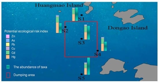
2.1. Description of the Study Area

The Huangmao Island marine dumping area is adjacent to the Pearl River Estuary, southeast of Hengqin Island, south of Huangmao Island, and northwest of the Wanshan Islands (Figure 1). The geographical coordinates are 113°38′30″–113°40′30″ E and 21°58′00″–22°01′00″ N, and the dumping area is approximately 20.6 km2. The Huangmao Island marine dumping area was approved in 1986. The dumping volume in the early stage was small but increased significantly since 2011. From 2011 to 2017, a total volume of 4762 × 104 m3 of dredged materials was dumped in this area. The dumping volume was the largest (1607 × 104 m3) in 2016 and the smallest (134 × 104 m3) in 2017. The sediment type in the dumping area was mainly silt, followed by sand and clay. The water depth of the dumping area gradually increased from the northwest to the southeast. In 2011, the water depth of the dumping area ranged from 8.2 to 14.4 m, with an average of 12.2 m. In 2017, the water depth ranged from 9.4 to 14.5 m, and the average value decreased by 0.3 m, of which the maximum decrease (1.2 m) was in the northwest of the dumping area.

2.2. Sampling

Surface sediment samples (0–5 cm) were collected from five sampling stations in October each year from 2011 to 2017. Because only a small amount of data was collected in 2015, the situation in 2015 was not included in this study. In addition, a benthic community investigation was conducted in the study area in 2017. Sediments were collected 2–3 times at each site by a grab sampler and then mixed and packed into pre-cleaned glass jars and frozen at −20 °C until further treatment. Benthos samples were collected using qualitative and quantitative methods. Quantitative samples of benthos were collected using a grab sampler. The samples were washed with seawater through a sieve with a diameter of 1 mm, and all biological samples were collected and transferred to a plastic container. Qualitative samples were collected with a 1.0 m wide Agassiz trawl. After dragging slowly for 10 min (approximately 200 m) at each station, all benthic organisms from the trawl were collected. Samples were bottled, numbered, and fixed with a 5% neutral formalin solution. Species were identified, counted, and weighed in the laboratory.

2.3. Laboratory Analysis

Before chemical analysis, sediments were freeze-dried to a constant weight. After removing the gravel and shells, the dried sediments were ground and sieved through a 96 μm stainless-steel sieve. Sediment samples (0.2000 g) for the measurement of Hg and As were digested with 10.0 mL of a mixture of acid (HNO3+HCl). Sediment samples (0.1000 g) for the measurement of Cu, Zn, Cd, and Pb were digested with a mixture of concentrated HNO3 (1.0 mL) and HClO4 (2.0 mL). HMs (Cu, Pb, Zn, and Cd) in the sediment samples were determined using a flame atomic absorption spectrometer (Analytik Jenna ContrAA 700). As and Hg in the sediment samples were tested using an atomic fluorescence spectrometer (Beijing Haiguang AFS 9560). Sulfide and TOC in sediment samples were determined by methylene blue spectrophotometry and potassium dichromate volumetric method, respectively. Oils were analyzed using a UV spectrophotometer (Shimadzu UV-2450). Eh and pH values of sediments were measured with a potentiometer and a pH meter, respectively. Although As is a metalloid that exhibits intermediate properties between those of metals and non-metals, this text refers to it as a metal. Organisms were sorted, counted, and identified to species level.
Quality assurance and quality control were evaluated using duplicates, blanks, and standard reference material (GB W07333) from the National Research Center for Standard of China. The detection limits of Hg, As, Cu, Pb, Cd, and Zn were 0.002, 0.06, 0.1, 0.1, 0.02, and 0.2 mg/Kg, respectively. All chemicals used for the analysis were of analytical grade or above. Blanks and duplicates were run for each batch of 10 samples. The blank values are below the detection limit. From the values of the duplicates, the relative errors of Hg, As, Cu, Pb, Cd, and Zn were below 6.5%, 1.8%, 2.5%, 3.7%, 5.9%, and 2.1%, respectively. The measured values of the standard reference material were within the error allowed. The results of quality assurance and quality control indicate that the accuracy and precision are acceptable.

2.4. Pollution and Ecological Risk Assessment Methods

2.4.1. Nemerow Pollution Index (Pi)

The Nemerow pollution index (Pi) was used to evaluate the sediments, as follows [22]:
P i j = C i j / S i
P i j a v e = 1 m i = 1 m P i j
P i = P i j m a x 2 + P i j a v e 2 / 2 1 / 2
where Pij is the standard index of the ith evaluation factor, Cij is the measured concentration of the ith evaluation factor, Si is the evaluation standard of the ith evaluation factor, m represents the number of evaluation factors, and Pijave and Pijmax refer to the average and maximum single factor pollution indices, respectively. The Nemerow pollution index was divided into five zones to describe pollution levels: unpolluted (≤0.7), lightly polluted (0.7 < Pi ≤ 1), mildly polluted (1 < Pi≤ 2), middle-level polluted (2 < Pi ≤ 3), and seriously polluted (Pi > 3).

2.4.2. Geochemical Accumulation Index (Igeo)

The pollution status of HMs in sediments was evaluated using the geochemical accumulation index (Igeo) as follows [23]:
I g e o = log 2 c i 1.5 × c B i
where Ci is the measured concentration of element i in the sediment, and CBi refers to the geochemical background value of an element. The geochemical accumulation index is divided into six zones to describe pollution levels: clean (Igeo < 0), light pollution (0 ≤ Igeo < 1), mild contamination (1 ≤ Igeo < 2), middle-level pollution (2 ≤ Igeo < 3), and serious contamination (Igeo ≥ 3).

2.4.3. Integrated Potential Ecological Risk Index (RI)

The ecological risk was evaluated using the potential ecological hazard index (RI) as follows [24]:
E r i = T r i × C f i = T r i   ×   C i C B i RI = i = 1 n E r i
where C f i is the accumulation factor of metal i, expressed as C f i  =  C i C B i ; Ci is the concentration of metal i in the sample; CBi is the geochemical background value of metal i in the sediments; and T r i is the toxicity coefficient of metal i. Eir is the individual ecological risk of metal i, and RI represents the potential ecological risk caused by overall contamination, which is the sum of all risk coefficients for metals.
Based on Eir value, the potential risk is classified into five categories: low risk (Eir ≤ 40), middle risk (40 < Eir ≤ 80), relatively high risk (80 < Eir ≤ 160), high risk (160 < Eir ≤ 320), and extra-high risk (Eir > 320). RI is classified into four categories to describe integrated potential ecological risk: low risk (RI < 150), middle risk (150 ≤ RI < 300), relatively high risk (300 ≤ RI < 600), and high risk (RI > 600).

2.5. Statistical Analysis

SPSS 25 was used to evaluate the correlation between HMs and environmental factors. Multivariate analysis was performed after the fourth root transformation of the abundance data from each sampling station. Outputs from n-MDS ordination models of the Bray–Curtis similarity matrix were obtained. For benthos data, n-MDS was conducted based on the abundance of taxa, density, and diversity of each sampling station. Multivariate analysis was conducted using PRIMER V5 software [25].

3. Results and Discussion

3.1. HMs in the Sediments

The concentrations of Hg, As, Cu, Pb, Cd, and Zn in surface sediments of the dumping area were 0.030–0.26, 7.90–19.8, 13.1–36.3, 17.4–54.7, 0.11–0.34, and 50.0–122 mg/kg, respectively, with an average of 0.080, 15.1, 24.5, 30.8, 0.21, and 97.6 mg/kg, respectively (Table 1).
If the concentrations of pollutants in the sediments are lower than the threshold effect level (TEL), adverse biological effects are expected to rarely occur. If the concentrations of pollutants in the sediments are higher than the probable effect level (PEL), adverse effects are expected to frequently occur. If the concentrations of pollutants in the sediment are between the TEL and PEL, the probability of adverse biological effects is close to that of no adverse biological effects. In this study, the concentration of As in the sediments was higher than the TEL in each year, that of Cu was higher than the TEL except in 2013 and 2017, and that of Pb was lower than the TEL except in 2011 and 2012. The concentrations of Hg, Zn, and Cd were lower than the TEL. The concentrations of all HMs were lower than the PEL. The HMs in sediments from the dumping area may have adverse biological effects. The effect range low (ERL) and effect range medium (ERM) were proposed by the National Oceanic and Atmospheric Administration [27]. The results showed that the concentration of As was higher than ERL, and that of other HMs was lower than ERL and ERM.
The concentrations of HMs in the surface sediments of all stations exceeded the background values of coastal sediments [26]. Hg, As, Cu, Pb, Cd, and Zn were approximately 2.7-, 1.9-, 1.6-, 1.5-, 3-, and 1.5-times higher than the coastal background values, respectively, indicating that the surface sediments of the dumping area have been slightly polluted over time. Although the concentrations of HMs in the sediments of the dumping area were higher than the background value, all the HMs except Hg fulfilled the class I standard of the Marine Sediment Quality Standard (MSQS) of China (GB 18668-2002). The quality of sediments in the marine dumping area was required to fulfill the class III standard of the MSQS. Therefore, the HM pollution was within an acceptable range. However, compliance with the sediment quality standards does not mean that HMs have no harm or risk, because the concentrations of HMs cannot fully reflect the pollution state [29], especially, the bioaccumulation and amplification of HMs in marine organisms pose potential health risks to human beings [30,31].
The coefficient of variation (CV%) was used to explain the changes in HM concentrations in different years. It reflects the average degree of variation of each sampling station in the samples. If the variation is greater than 0.5, the spatial distribution of HM concentrations in the sediments is uneven, and local point source pollution may exist [32]. The CV% of Hg in the sediments of the Huangmao Island dumping area was greater than 0.5, indicating that Hg entering the dumping area was mainly sourced from external input, that is, dumping. The coefficients of variation of Pb, Cu, As, and Zn were all smaller than 0.5, indicating that these HMs were relatively stable. There is a dynamic process between the release and absorption of HMs in marine sediments. In this process, different physicochemical characteristics (e.g., pH, redox potential, temperature, particle size, and salinity), ocean current, and dumping intensity will cause changes in the CV% values of HMs in sediments [33].
Compared with other dumping areas, HM concentrations in the Huangmao Island dumping area were generally at an intermediate level (Table 2). For individual HMs, the Hg concentration was close to the levels recorded in the Jinzhou Port Dumping Area [34] and Marine Dumping Area outside Jiaozhou Bay [35]. The As concentration was close to the levels recorded in the Hulu Island Port Dumping Area [34] and Tianjin Dumping Area [34]. The Zn concentration was close to the levels recorded in the Hulu Island Port Dumping Area [34], Fangchenggang Dumping Area [36], and Dumping Site at the Taiwan Shelf [37]. The Cd concentration was close to the levels recorded in the Jinzhou Port Dumping Area [34], Huangye Port Dumping [34], Lanshan Port Temporary Marine Dumping Area [38], and Marine Dumping Area outside Jiaozhou Bay [35]. Last, the Pb concentration was similar to those recorded in the Huangye Port Dumping Area [34], Laizhou Port Dumping Area [34], and Fangchenggang Dumping Area [36].

3.2. Temporal and Spatial Distribution Characteristics of HMs

Changes in the concentrations of HMs in the surface sediments in different years are shown in Figure 2. The highest concentrations of Hg, As, Cu, Pb, Cd, and Zn were observed in 2016, 2012, 2013, 2012, 2016, and 2011, respectively. In 2017, the concentrations of all HMs were the lowest, which might be related to the significant reduction in the dumping amount in 2017. From 2011 to 2016, the concentrations of As, Cu, and Pb did not change significantly, that of Zn first decreased and then increased, and those of Hg and Cd increased. Changes in HM concentrations in sediments were affected by multiple factors, such as the pollution level of dumped dredged materials, dumping volume, and hydrodynamic characteristics of the dumping area.
Spatial distribution profiles of the HMs in the sediments from the study area are shown in Figure 3. Concentrations of HMs in surface sediments generally showed a high trend in the north and central areas of the dumping area and a low trend in the south of the dumping area. The concentration of Cd was higher in the dumping area but lower outside the dumping area; it reached its highest value at station S3 (in the center of the dumping area) and the lowest at station S5 (in the south outside the dumping area). The concentration of Pb was higher in the central and south of the dumping area but lower in the northwest; it reached its highest value at station S3 and the lowest at station S2 (at the edge of the dumping area). The concentrations of Hg and As gradually decreased from northwest to southeast, reaching the highest at station S2 and the lowest at station S5. The concentration of Cu gradually decreased from north to south, reaching its highest at station S1 and lowest at station S4. The concentration of Zn gradually decreased from north to south in the dumping area, reaching its highest at station S5 and lowest at station S2.

3.3. Correlation Analysis between HMs and Other Environmental Factors

The concentrations of HMs in surface sediments are affected by various conditions, including environmental background, marine physical and chemical properties, biological effects, and human activities [39]. Analyzing the correlation between HMs and environmental factors (e.g., oils, TOC, sulfides) is helpful in determining the possible sources of HMs [40].
In this study, the data followed a normal distribution, and the Pearson coefficient analysis was performed using SPSS 25 software. In Table 3, organic carbon had a significant positive correlation with Cu and Zn (p < 0.01), indicating that Cu and Zn were closely related to organic matter, which was a main carrier. Additionally, organic carbon and HMs easily form organic matter complexes. Therefore, organic carbon plays an important role in the distribution of HMs. Among the six HMs, Zn was significantly correlated with Cu (p< 0.01) and moderately correlated with As and Pb (p < 0.05). Hg and Cd were significantly correlated with As but not with the other three HMs, implying that Hg and Cd might have sources similar to As, which differed from those of other metals. Oils and sulfides were not correlated with the concentrations of the six HMs, indicating that they had no effect on HMs in the dumping area.

3.4. Pollution Assessment of HMs in Sediments

Pollution assessments for HMs in sediments have been conducted widely based on several indices, such as the Nemerow pollution index, Eir, RI, and Igeo [22,41,42].
The Nemerow index was used to evaluate the pollution of HMs in the sediments in the dumping area over different years (Figure 4). In 2012, 2013, and 2016, the Nemerow index exceeded 0.7 but was less than 1. This finding indicated that the sediments in the dumping area had reached light pollution levels in 2012, 2013, and 2016. Sediments in other years were at a clean level. The pollution level in 2016 was slightly higher, which might be related to larger quantity of dumping materials in this year. According to the pollution distribution, the polluted areas were mainly in the northwest (S1 and S2) and central areas (S3) of the dumping area. Additionally, the change in water depth showed that these stations were areas with large dumping quantities, indicating that dumping might have a negative impact on sediments.
The Igeo values of As, Cu, Zn, and Pb ranged from 0 to 1 from 2011 to 2016 (Figure 5), indicating that the pollution levels of these four HMs were light pollution. Notably, in 2017, the Igeo values of As, Cu, Zn, and Pb were lower than 0, implying that the pollution levels of these four metals were not polluted in 2017, which may be related to the least dumping amount in this year. In most years, the Igeo values of Hg and Cd were between 1.0 and 2.0, indicating that Hg and Cd had reached a mild contamination level. From 2011 to 2016, the pollution levels of Hg and Cd showed an increasing trend and were higher than those of the other four HMs. Even in 2017, when the dumping amount was the lowest, the pollution levels of Hg and Cd were rated as light pollution, and the pollution from the other four HMs was not observed. Therefore, special attention should be paid to Hg and Cd before dumping dredged materials.
Figure 6 shows the integrated potential ecological risk index (RI) and potential ecological risk index (Eir) of an individual HM. The RI values of HMs in the sediments of the dumping area were higher than 150 in 2011, 2013, 2014, and 2017, suggesting that HMs had a middle ecological risk. The RI values in 2012 and 2016 were 310 and 388, respectively, indicating that the ecological risk of sediments was relatively high. The RI values of the dumping area were greater than 150 every year, implying that the potential ecological risk of the dumping area must be paid more attention.
For individual metals, Hg and Cd posed more severe ecological risk than the other HMs, with Eir values higher than 40 in each year from 2011 to 2017, especially in 2016, a high risk level (Eir ≥ 160). The Eir values of other HMs were less than 40, indicating that the potential ecological risk of other HMs was low. In general, Hg and Cd were the main factors causing the potential ecological risks of sediments in the study area.
At present, extensive ecological risk assessments have been conducted on HMs in sediments based on RI [31,43]. In these studies, contamination levels or risk contributions of HMs varied across study areas. For example, Cd was the largest contributor to the ecological risk of sediments [43]. Similar to the results of this study, Lao et al. [31] observed that the ecological risk of Hg in the Beibu Gulf was relatively high, and Tang et al. [42] found that the ecological risk of Hg and Cd in HMs in Daya Bay was also high. Liu et al. [33] found that the ecological risk of Hg in the sediments of the Maowei River aquaculture area was high. Hg and Cd had stronger toxic effects on organisms [44]. The toxicity coefficients (Tri) of Hg and Cd were 40 and 30, respectively, much higher than those of the other four HMs, which led to a higher potential risk in sediments of the dumping area. Hg and Cd have strong biological toxicity and high bioaccumulation potential, which seriously threaten marine ecosystems and human health. Therefore, to reduce the ecological risk caused by dumping, the monitoring of Hg and Cd in dredged materials should be strengthened before ocean dumping.
The Eir values of HMs at the different stations are shown in Figure 6. In terms of spatial distribution, the order of the potential ecological risk of each monitoring station was S2 > S3 > S4 > S1 > S5. Areas with high ecological risk were mostly located in the northwest of the dumping area, and the ecological risk in the south of the dumping area are low. In the north of the dumping area, the results of ecological risk are consistent with the concentration distribution and the Nemerow evaluation results. In areas (S1, S2, and S3) with frequent dumping, higher concentrations of HMs in sediments were detected, indicating that dumping activities had a significant impact on the marine ecological environment.

3.5. Characteristics of Benthic Community in the Dumping Area

Fifty-two species of benthos were identified and characterized by the presence of the following groups: arthropods, chordates, annelids, mollusks, echinoderms, nemertinean, coelenterate, and echiuran. Among these groups, arthropods were the most abundant, accounting for 38.5% of all benthos, and chordate, annelid, and mollusks accounted for 25.0%, 15.4%, and 13.5%, respectively. Benthic communities differ in their substrate requirements, and different species dwell indifferent ecosystems [45,46]. After investigating the benthos in Riga Bay in the eastern Baltic Sea, Pallo et al. [47] found that arthropods were more suitable for coarse sand sediment environments. In this study, the similar result was found. Sediments in the Huangmao Island dumping area were mainly silt and the most abundant benthos in this area was arthropods.
A general belief is that filter-feeding benthos are more likely to enrich HMs [48]. However, Quan et al. [49] found that arthropods can easily affect the biological community structure and biomass amount by adsorbing HMs from sediments.
The abundance of taxa, individual density of benthos, and diversity of the benthic fauna are shown in Figure 7. There was little difference in the abundance of taxa, density, and diversity between the central area (S3) and the northwest area (S1 and S2). The abundance of taxa and density of S4 in the southeast corner of the dumping area was low, and those of S5 located to the south of the dumping area were significantly higher than those at the other stations. The response of benthic communities to cumulative dumping was analyzed based on the abundance of taxa, density, and diversity of each station in the dumping area. The abundance of taxa, density, and diversity of benthos at each station were transformed by logarithmic conversion to create a Bray–Curtis similarity matrix and to conduct clustering and MDS sequencing. The results are presented in Figure 8. The benthic fauna community in the study area was divided into four groups at a similar level of 92.9%. S1 and S3 belong to group 1, in the central area and to the northern part of the dumping area. S2 belongs to group 2, in the northwest corner of the dumping area. Groups 1 and 2 had a high similarity. S4 belongs to group 3, in the southeast corner of the dumping area. S5 belongs to group 4, outside the dumping area. Stations in groups 1 and 2 were the areas with the largest dumping amount and higher ecological risk. Stations in groups 3 and 4 were the areas with less dumping amount than group 1 and 2, and pollution and ecological risk were also lower. The temporal and spatial distribution characteristics of benthic communities were highly related to the pollution levels in different dumping areas.

3.6. Influence of Dumping Dredged Materials and the Pollution Status

To minimize the impact of dumping on the marine ecological environment, the dumping distance, hydrodynamic conditions, water depth, and other factors were comprehensively considered during the selection of the location of the Huangmao Island dumping area. In the case of large amounts of dumping and complex types of dredged materials, benthos was affected even during short-term dumping [3]. HMs in dredged materials enter sediments in different ways, causing changes in the sediment environment and affecting the structure and composition of organisms. Jia et al. [50] found that the concentrations of Cu, Pb, and Cd in sediments had a significant impact on the richness and equity of benthos. Li et al. [51] found that the correlation coefficient between the HM content in sediments and the community structure was the highest, and the content of HMs in sediments was the main environmental factor affecting the community structure of benthos in this area. The HMs in seawater can enter the sediment in different ways, which can change the sediment environment and affect the structure and composition of organisms.
The abundance of taxa, density, and diversity have been widely used in the impact assessment of benthos [52]. In this study, there were significant differences in the abundance of taxa and density between the areas inside and outside the dumping area. The abundance of taxa and density outside the dumping area were significantly higher than those inside the dumping area, indicating that dumping dredged materials might affect the benthos. The n-MDS analysis confirmed the observed patterns, separating the S5 stations from the others (S1–S4). Similar to this study, Fonseca et al. [48] also found that the area with more concentrated dumping had more severe pollution and lower richness of benthos. The Nemerow index showed that the central and northern parts of the Huangmao island dumping area (S1, S2, and S3) were polluted, and the RI values of HMs in this area were relatively high. Zhang et al. [38] investigated the sediments in the Lanshan Port temporary marine dumping area and found that the concentrations of HMs in the dumping area were significantly higher than those outside the dumping area, corroborating the results of this study.
The results of this study clearly indicate that the source of HMs in the dumping area are mainly from the dumped dredged materials, and dumping had affected the abundance of taxa and the density of benthos, especially in areas with a large dumping quantity and high dumping frequency. Since metal concentrations and evaluation of metal accumulation in benthos were not conducted in this study, the differences in the characteristics of the benthic community between the areas inside and outside the dumping area cannot be directly associated to HM content only. Community structure and composition can also be directly affected by the burial of dumping materials [53]. Other factors, such as dumping amount, dumping frequency, the type of dredged material, and toxicity of the dredged material also change the structure and composition of the benthic community.

4. Conclusions

The average concentrations of Hg, As, Cu, Pb, Cd, and Zn in surface sediments of the dumping area were 0.080, 15.1, 24.5, 30.8, 0.21, and 97.6 mg/kg, respectively. HMs in the surface sediments of the study area generally showed a trend of high in the northwest and central areas and low in the southeast of the dumping area. All HMs, except for Hg, met the class I standard for MSQS. The Nemerow index showed that sediments in the dumping area were at a light pollution level, and the polluted areas were mainly in the northwest and central areas with large dumping amounts. The values of Igeo showed that the dumping area was at a mild contamination level, and Hg and Cd were the major pollutants. The RI of the dumping area was relatively high. Hg and Cd are the main factors that cause the potential ecological risk of sediments. Areas with high potential ecological risk and high pollution levels were mainly those that undertake frequent and large dumping amounts of dredged materials.
Benthos identified in this study include arthropods, chordates, annelids, mollusks, echinoderms, nemertineans, coelenterates, and echiurans. Among these groups, arthropods were the most abundant, accounting for 38.5% of all benthos, and chordate, annelid, and mollusks accounted for 25.0%, 15.4%, and 13.5%, respectively. The abundance of taxa and density of benthic organisms showed little difference among the stations within the dumping area but were significantly lower than those of the stations outside the dumping area. It can be inferred that dumping dredged materials in the Huangmao Island marine dumping area had a negative impact on the benthos.
The assessment of HMs in the dumping area indicated that the pollutants in the dredged materials may have harmful effects on benthos. As, Hg, and Cd must be treated before dumping dredged materials. To study the impact of HMs more objectively in dumping dredged materials on marine organisms, metal concentration evaluation in benthic organisms and the toxicity test in sediments of dumping areas should be evaluated in further research. Additionally, the dumping area should be managed by zones to avoid intensive dumping in the northern part.

Author Contributions

Conceptualization, W.T. and Z.J.; methodology, W.T. and Z.J.; validation, X.P. and Z.Y.; investigation, Z.J.; data curation, H.Y. and J.Y.; writing—original draft preparation, W.T. and J.Y.; writing—review and editing, W.C. and W.T.; supervision, Z.J. and J.Y.; Funding acquisition, W.T. and J.Y. All authors have read and agreed to the published version of the manuscript.

Funding

This research was funded by State Oceanic Administration, grant number DOMEP-01-03.

Institutional Review Board Statement

Not applicable.

Informed Consent Statement

Not applicable.

Data Availability Statement

Data employed in this study will be available on request to the corresponding authors.

Acknowledgments

The authors would like to thank the technicians from South China Sea Environment Monitoring Center, China for sample collection and analysis.

Conflicts of Interest

The authors declare no conflict of interest.

References

  1. Song, K.-H.; Choi, K.-Y.; Kim, C.-J.; Kim, Y.-I.; Chung, C.-S. Assessment of the Governance System for the Management of the East Sea-Jung Dumping Site, Korea through Analysis of Heavy Metal Concentrations in Bottom Sediments. Ocean Sci. J. 2015, 50, 721–740. [Google Scholar] [CrossRef]
  2. Fatoki, O.S.; Mathabatha, S. An Assessment of Heavy Metal Pollution in the East London and Port Elizabeth Harbours. Water Sa 2001, 27, 233–240. [Google Scholar] [CrossRef] [Green Version]
  3. Katsiaras, N.; Simboura, N.; Tsangaris, C.; Hatzianestis, I.; Pavlidou, A.; Kapsimalis, V. Impacts of Dredged-Material Disposal on the Coastal Soft-Bottom Macrofauna, Saronikos Gulf, Greece. Sci. Total Environ. 2015, 508, 320–330. [Google Scholar] [CrossRef] [PubMed]
  4. Harvey, M.; Gauthier, D.; Munro, J. Temporal Changes in the Composition and Abundance of the Macro-Benthic Invertebrate Communities at Dredged Material Disposal Sites in the Anse a Beaufils, Baie Des Chaleurs, Eastern Canada. Mar. Pollut. Bull. 1998, 36, 41–55. [Google Scholar] [CrossRef]
  5. State Oceanic Administration of China. Bulletin of China Marine Ecological Environment Status; Ocean Press: Beijing, China, 2011–2017. [Google Scholar]
  6. Marmin, S.; Lesueur, P.; Dauvin, J.C.; Samson, S.; Tournier, P.; Lavanne, A.G.; Dubrulle-Brunaud, C.; Thouroude, C. An Experimental Study on Dredge Spoil of Estuarine Sediments in the Bay of Seine (France): A Morphosedimentary Assessment. Cont. Shelf Res. 2016, 116, 89–102. [Google Scholar] [CrossRef]
  7. Moog, O.; Stubauer, I.; Haimann, M.; Habersack, H.; Leitner, P. Effects of Harbour Excavating and Dredged Sediment Disposal on the Benthic Invertebrate Fauna of River Danube (Austria). Hydrobiologia 2018, 814, 109–120. [Google Scholar] [CrossRef]
  8. Guerra-Garcia, J.; Garcia-Gomez, J. Polychaete Assemblages and Sediment Pollution in a Harbour with Two Opposing Entrances. Helgol. Mar. Res. 2004, 58, 183–191. [Google Scholar] [CrossRef] [Green Version]
  9. Islam, M.S.; Ahmed, M.K.; Raknuzzaman, M.; Habibullah-Al-Mamun, M.; Islam, M.K. Heavy Metal Pollution in Surface Water and Sediment: A Preliminary Assessment of an Urban River in a Developing Country. Ecol. Indic. 2015, 48, 282–291. [Google Scholar] [CrossRef]
  10. Abdel-Ghani, N.T.; Elchaghaby, G.A. Influence of Operating Conditions on the Removal of Cu, Zn, Cd and Pb Ions from Wastewater by Adsorption. Int. J. Environ. Sci. Technol. 2007, 4, 451–456. [Google Scholar] [CrossRef] [Green Version]
  11. Yuan, H.; Song, J.; Li, X.; Li, N.; Duan, L. Distribution and Contamination of Heavy Metals in Surface Sediments of the South Yellow Sea. Mar. Pollut. Bull. 2012, 64, 2151–2159. [Google Scholar] [CrossRef]
  12. Gleyzes, C.; Tellier, S.; Astruc, M. Fractionation Studies of Trace Elements in Contaminated Soils and Sediments: A Review of Sequential Extraction Procedures. Trac Trends Anal. Chem. 2002, 21, 451–467. [Google Scholar] [CrossRef]
  13. Peng, B.; Peng, J.X.; Sun, K.F. A review on heavy metals contamination in Daya Bay and adjacent waters. Ecol. Sci. 2015, 34, 170–180. [Google Scholar]
  14. Bolam, S.G.; Barry, J.; Bolam, T.; Mason, C.; Rumney, H.S.; Thain, J.E.; Law, R.J. Impacts of Maintenance Dredged Material Disposal on Macrobenthic Structure and Secondary Productivity. Mar. Pollut. Bull. 2011, 62, 2230–2245. [Google Scholar] [CrossRef]
  15. Newell, R.C.; Seiderer, L.J.; Hitchcock, D.R. The Impact of Dredging Works in Coastal Waters: A Review of the Sensitivity to Disturbance and Subsequent Recovery of Biological Resources on the Sea Bed. Oceanogr. Mar. Biol. D 1998, 36, 127–178. [Google Scholar]
  16. Vandolah, R.; Calder, D.; Knott, D. Effects of Dredging and Open-Water Disposal on Benthic Macroinvertebrates in a South-Carolina Estuary. Estuaries 1984, 7, 28–37. [Google Scholar] [CrossRef]
  17. Roberts, R.D.; Forrest, B.M. Minimal Impact from Long-Term Dredge Spoil Disposal at a Dispersive Site in Tasman Bay, New Zealand. N. Z. J. Mar. Freshw. Res. 1999, 33, 623–633. [Google Scholar] [CrossRef] [Green Version]
  18. Roberts, R.D.; Gregory, M.R.; Foster, B.A. Developing an Efficient Macrofauna Monitoring Index from an Impact Study—A Dredge Spoil Example. Mar. Pollut. Bull. 1998, 36, 231–235. [Google Scholar] [CrossRef]
  19. State Oceanic Administration of China. Technical Guidelines for Selecting of Ocean Dumping Area (HY/T122-2009); Standard Press: Beijing, China, 2009. [Google Scholar]
  20. Donazar-Aramendia, I.; Sanchez-Moyano, J.E.; Garcia-Asencio, I.; Miro, J.M.; Megina, C.; Garcia-Gomez, J.C. Impact of Dredged-Material Disposal on Soft-Bottom Communities in a Recurrent Marine Dumping Area near to Guadalquivir Estuary, Spain. Mar. Environ. Res. 2018, 139, 64–78. [Google Scholar] [CrossRef]
  21. Wang, X.; Kong, L.; Cheng, J.; Zhao, D.; Chen, H.; Sun, R.; Yang, W.; Han, J. Distribution of Butyltins at Dredged Material Dumping Sites around the Coast of China and the Potential Ecological Risk. Mar. Pollut. Bull. 2019, 138, 491–500. [Google Scholar] [CrossRef]
  22. Yan, N.; Liu, W.; Xie, H.; Gao, L.; Han, Y.; Wang, M.; Li, H. Distribution and Assessment of Heavy Metals in the Surface Sediment of Yellow River, China. J. Environ. Sci. 2016, 39, 45–51. [Google Scholar] [CrossRef]
  23. Muller, G. Index of Geoaccumulation in Sediments of the Rhine River. Geojournal 1969, 2, 108–118. [Google Scholar]
  24. Hakanson, L. An Ecological Risk Index for Aquatic Pollution-Control—A Sedimentological Approach. Water Res. 1980, 14, 975–1001. [Google Scholar] [CrossRef]
  25. Clarke, K.R.; Warwick, R.M. Change in Marine Communities: An. Approach to Statistical Analysis and Interpretation; Plymouth Marine Laboratory: Plymouth, UK, 1994. [Google Scholar]
  26. Zhang, Y. A Background Value Study on Heavy Metal Elements in the Sediments of Daya Bay. Trop. Ocean. 1991, 3, 76–80. [Google Scholar]
  27. MacDonald, D.D.; Carr, R.S.; Calder, F.D.; Long, E.R.; Ingersoll, C.G. Development and Evaluation of Sediment Quality Guidelines for Florida Coastal Waters. Ecotoxicology 1996, 5, 253–278. [Google Scholar] [CrossRef]
  28. Long, E.; Macdonald, D.; Smith, S.; Calder, F. Incidence of Adverse Biological Effects Within Ranges of Chemical Concentrations in Marine and Estuarine Sediments. Environ. Manag. 1995, 19, 81–97. [Google Scholar] [CrossRef]
  29. Rauret, G. Extraction Procedures for the Determination of Heavy Metals in Contaminated Soil and Sediment. Talanta 1998, 46, 449–455. [Google Scholar] [CrossRef]
  30. Bonsignore, M.; Manta, D.S.; Mirto, S.; Quinci, E.M.; Ape, F.; Montalto, V.; Gristina, M.; Traina, A.; Sprovieri, M. Bioaccumulation of Heavy Metals in Fish, Crustaceans, Molluscs and Echinoderms from the Tuscany Coast. Ecotoxicol. Environ. Saf. 2018, 162, 554–562. [Google Scholar] [CrossRef]
  31. Lao, Q.; Su, Q.; Liu, G.; Shen, Y.; Chen, F.; Lei, X.; Qing, S.; Wei, C.; Zhang, C.; Gao, J. Spatial Distribution of and Historical Changes in Heavy Metals in the Surface Seawater and Sediments of the Beibu Gulf, China. Mar. Pollut. Bull. 2019, 146, 427–434. [Google Scholar] [CrossRef] [PubMed]
  32. Adila, S.; Mamattursun, E.; Alimujiang, K. Assessment of Pollution and Ecological Risk of Heavy Metals in Surface Dust in Karamay City. Asian J. Ecotoxicol. 2021, 16, 310–322. [Google Scholar] [CrossRef]
  33. Liu, J.; Zhang, J.; Lu, S.; Zhang, D.; Tong, Z.; Yan, Y.; Hu, B. Interannual Variation, Ecological Risk and Human Health Risk of Heavy Metals in Oyster-Cultured Sediments in the Maowei Estuary, China, from 2011 to 2018. Mar. Pollut. Bull. 2020, 154, 111039. [Google Scholar] [CrossRef] [PubMed]
  34. Zheng, L.; Liu, Y.; Yuan, Y.; Zhou, C.Y.; Qu, L. Enrichment of Heavy Metals in the Surface Sediments from the Dumping Areas in Bohai Sea and Assessment of Their Potential Ecological Risk. Mar. Sci. Bull. 2014, 33, 340–346. [Google Scholar]
  35. Zhang, N.X.; Cao, C.H.; Ren, R.Z.; Sun, X. Heavy Metals in the Surface Sediment of the Dumping Ground Outside Jiaozhou Bay and Their Potential Ecological Risk. HuanjingKexue 2011, 32, 1315–1320. [Google Scholar]
  36. Liu, G.Q.; Liu, B.L.; Qing, S.M.; Xing, S.K. Assessment on Pollution and Potential Ecological Risk of Heavy Metals in the Sediments of the Temporary Marine Dumping Area of Fangchenggang. Ecol. Sci. 2013, 32, 177–182. [Google Scholar]
  37. Chen, C.F.; Chen, C.W.; Ju, Y.R.; Kao, C.M.; Dong, C.D. Impact of Disposal of Dredged Material on Sediment Quality in the Kaohsiung Ocean Dredged Material Disposal Site, Taiwan. Chemosphere 2018, 191, 555–565. [Google Scholar] [CrossRef]
  38. Zhang, L.; Ren, R.Z.; Wu, F.C.; Wang, J.W.; Zhang, N.X. Analysis on the Distribution of Surface Sediment Heavy Metals Contamination and the Influencing Factors of Temporary Ocean Dumping Site in Lanshan Port. Trans. Oceanol. Limnol. 2012, 1, 130–136. [Google Scholar]
  39. Hilton, J.; Davison, W.; Ochsenbein, U. A Mathematical-Model for Analysis of Sediment Core Data—Implications for Enrichment Factor Calculations and Trace-Metal Transport Mechanisms. Chem. Geol. 1985, 48, 281–291. [Google Scholar] [CrossRef]
  40. Sundaray, S.K.; Nayak, B.B.; Lin, S.; Bhatta, D. Geochemical Speciation and Risk Assessment of Heavy Metals in the River Estuarine Sediments-A Case Study: Mahanadi Basin, India. J. Hazard. Mater. 2011, 186, 1837–1846. [Google Scholar] [CrossRef] [PubMed]
  41. Liu, B.; Wang, J.; Xu, M.; Zhao, L.; Wang, Z. Spatial Distribution, Source Apportionment and Ecological Risk Assessment of Heavy Metals in the Sediments of Haizhou Bay National Ocean Park, China. Mar. Pollut. Bull. 2019, 149, 110651. [Google Scholar] [CrossRef]
  42. Tang, H.; Ke, Z.; Yan, M.; Wang, W.; Nie, H.; Li, B.; Zhang, J.; Xu, X.; Wang, J. Concentrations, Distribution, and Ecological Risk Assessment of Heavy Metals in Daya Bay, China. Water 2018, 10, 780. [Google Scholar] [CrossRef] [Green Version]
  43. Cao, Y.; Lei, K.; Zhang, X.; Xu, L.; Lin, C.; Yang, Y. Contamination and Ecological Risks of Toxic Metals in the Hai River, China. Ecotoxicol. Environ. Saf. 2018, 164, 210–218. [Google Scholar] [CrossRef]
  44. Lin, L.H.; Wei, H.J.; Huang, H.M. Contamination status and bioaccumulation of the heavy metals in the surface sediments and benthos in Daya Bay. Ecol. Sci. 2017, 36, 173–181. [Google Scholar]
  45. Sarr, A.B.; Joao Benetti, C.; Fernandez-Diaz, M.; Garrido, J. The Microhabitat Preferences of Water Beetles in Four Rivers in Ourense Province, Northwest Spain. Limnetica 2013, 32, 1–9. [Google Scholar]
  46. de Castro Vasconcelos, M.; Melo, A.S. An Experimental Test of the Effects of Inorganic Sediment Addition on Benthic Macroinvertebrates of a Subtropical Stream. Hydrobiologia 2008, 610, 321–329. [Google Scholar] [CrossRef]
  47. Pallo, P.; Widbom, B.; Olafsson, E. A Quantitative Survey of the Benthic Meiofauna in the Gulf of Riga (Eastern Baltic Sea), with Special Reference to the Structure of Nematode Assemblages. Ophelia 1998, 49, 117–139. [Google Scholar] [CrossRef]
  48. Fonseca, E.M.; Fernandes, J.R.; Lima, L.S.; Delgado, J.; Correa, T.R.; Costa, P.M.S.; Baptista Neto, J.A.; Aguiar, V.M.C. Effects of Dredged Sediment Dumping on Trace Metals Concentrations and Macro Benthic Assemblage at the Continental Shelf Adjacent to a Tropical Urbanized Estuary. Ocean. Coast. Manag. 2020, 196, 105299. [Google Scholar] [CrossRef]
  49. Quan, F. Intertidal Pollution on Benthic Macro-Arthropod Community in Mangrove Forest. Master’s Thesis, Hainan Normal University, Hainan, China, 2011. [Google Scholar]
  50. Jia, H.B.; Hu, H.Y.; Tang, J.L.; Wang, Y.M.; Chai, H.P. Effect of Heavy Metals on Macro-Benthos in Surface Sediments in Changjiang Estuary and Adjacent Sea. Mar. Environ. Sci. 2011, 30, 809–813. [Google Scholar]
  51. Li, X.Z.; Li, B.Q.; Wang, H.F. Community Structure of Macrobenthos in Coastal Water off Rushan, Southern Shandong Peninsula, and the Relationships with Environmental Factors. Acta Oceanol. Sin. 2009, 28, 81–93. [Google Scholar]
  52. Xu, R.; Yang, Y.; Li, Z. Diffusion of Heavy Metals from Marine Environment to Shellfish. Mar. Sci. Bull. 2007, 26, 117–120. [Google Scholar]
  53. Simonini, R.; Ansaloni, I.; Cavallini, F.; Graziosi, F.; Iotti, M.; N’Siala, G.M.; Mauri, M.; Montanari, G.; Preti, M.; Prevedelli, D. Effects of Long-Term Dumping of Harbor-Dredged Material on Macrozoobenthos at Four Disposal Sites along the Emilia-Romagna Coast (Northern Adriatic Sea, Italy). Mar. Pollut. Bull. 2005, 50, 1595–1605. [Google Scholar] [CrossRef]
Figure 1. Sampling stations at the dumping area and adjacent sea areas.
Applsci 11 09412 g001
Figure 2. Average concentrations of HMs in surface sediments in different years.
Applsci 11 09412 g002
Figure 3. Spatial distribution of HMs in sediments.
Applsci 11 09412 g003
Figure 4. The Nemerow pollution index of HMs in different years.
Applsci 11 09412 g004
Figure 5. The Igeo values of HMs in different years.
Applsci 11 09412 g005
Figure 6. RI of HMs in different years (A) and Eir of HMs in different stations (B).
Applsci 11 09412 g006
Figure 7. The abundance of taxa, individual density of benthos, and diversity for the benthic fauna (Shannon–Wiener index).
Applsci 11 09412 g007
Figure 8. Cluster and n-MDS plots based on abundance of taxa, density, and diversity in each station.
Applsci 11 09412 g008
Table 1. The concentrations of HMs in the dumping area (unit: mg/kg).
HgAsCuPbCdZnReferences
20110.050–0.09014.2–17.420.2–31.529.7–32.30.15–0.21108–117
20120.056–0.1416.4–19.621.1–29.623.0–54.70.16–0.2797.4–122
20130.054–0.08616.1–17.819.8–36.319.9–36.00.16–0.3466.1–116
20140.052–0.1214.2–17.920.3–26.721.6–33.40.16–0.2862.2–122This study
20160.053–0.2614.2–19.821.8–25.425.4–32.80.22–0.3288.6–119
20170.030–0.0507.90–10.913.1–21.717.4–35.60.11–0.2450.0–83.0
Average a ± standard deviation0.080 ± 0.04115.1 ± 3.2024.5 ± 4.4030.8 ± 7.700.21 ± 0.06197.6 ± 20.5
Coefficient of variation (CV%) b0.510.210.180.250.290.21
Class I c0.22035600.5150
Background0.037.715200.0765[26]
TEL d0.137.2418.730.20.68124[27]
PEL e0.741.61081124.21271[27]
ERL f0.158.23446.71.2150[28]
ERM j0.71702702189.6410[28]
a Average value of all the samples over six years. b CV%=average/standard deviation. c Standard of the Marine Sediment Quality Standard (MSQS) of China (GB 18668-2002). d Threshold effect level. e Probable effect level. f Effect range low from the National Oceanic and Atmospheric Administration (NOAA). j Effect range medium from the National Oceanic and Atmospheric Administration (NOAA).
Table 2. The concentrations of HMs in sediments from other dumping areas.
LocateHgAsCuPbCdZnReference
mg/kg
Huangmao Island
Dumping Area
0.03–0.267.9–19.813.1–36.317.4–54.70.10–0.3450–122This study
Hulu Island Port
Dumping Area
0.31–0.366.07–10.515.6–20.712–18.50.17–0.6363.1–126[34]
Jinzhou Port
Dumping Area
0.10–0.264.97–8.620.15–0.4510.7–17.50.15–0.4522.8–234
Tianjin Dumping Area0.016–0.02316–250.112–0.14920.5–23.40.112–0.14953.9–66.5
Huangye Port
Dumping Area
0.016–0.01950.9–73.10.167–0.2317.2–23.70.156–0.2016.37–7.71
Laizhou Port
Dumping Area
0.015–0.0616.91–10.710.22–0.2419.1–23.50.22–0.2458.6–64.2
Marine Dumping Area
outside Jiaozhou Bay
0.038–0.082NA2.79–3.840.99–1.320.09–0.133.73–16.16[35]
Fangchenggang Dumping
Area
0.063–0.0719.02–9.8913.8–16.726.2–32.10.02–0.1131.7–79.5[36]
Dumping Site
at Taiwan Shelf
NANA12.5–15.615.6–18.5NA101.3–124.7[37]
Lanshan Port
Temporary Marine
Dumping Area
0.038–0.082NA10.32–13.677–9.150.15–0.1722.59–28.15[38]
Table 3. Correlation analysis for HMs, TOC, Oils, and sulfides in sediments.
TOCHgAsCuPbCdZnOilsSulfides
TOC1
Hg0.1391
As0.4930.657 **1
Cu0.663 **0.2450.4841
Pb0.4380.060.1030.441
Cd0.0170.4190.723 **0.1790.1871
Zn0.661 **0.2690.549 *0.766 **0.515 *0.2541
Oils0.363−0.0160.160.1640.450.2430.4511
Sulfides0.2130.017−0.2490.052−0.002−0.556 *−0.1640.0121
* Correlation is significant at the 0.05 level (two-tailed). ** Correlation is significant at the 0.01 level (two-tailed).
Publisher’s Note: MDPI stays neutral with regard to jurisdictional claims in published maps and institutional affiliations.

