Abstract
Beyond the importance of ponds for aquatic and terrestrial life, pond networks seem to be crucial to providing a vital spatial resource in response to global climate change for all migrating and spreading taxa. Additionally, ponds offer sustainable solutions to issues of concern in water management, such as nutrient retention, rainfall interception, or carbon sequestration. Although the ecological role of shallow waters seems clear, significant work must be performed to set future guidelines and actions towards their conservation. The main aims of the present study are to (i) georeference all small temporary wetlands within the Tyrrhenian central Italy coastal area, (ii) evaluate their hydroperiod, and (iii) calculate their surface size variability. We found 137 wetlands, 53 of which were temporary and contained listed habitats. Each wetland’s status was assessed in relation to land use and proximity to stressors (e.g., urban centres, railways, roads) while observing the relationship between pond occurrence, lithology, and permeability. Amongst the detected wetlands, we selected and monitored 21 temporary ponds (homogeneously distributed within the study area) for 12 months using images collected by the non-professional drone Parrot Bebop 2. All images were then acquired in ArcGIS to georeference all temporary ponds. The analysis confirmed that the majority of the surveyed ponds are in close proximity to roads and tracks, which might have significant impacts on the preservation of such fragile habitats. Moreover, despite the wide variability of hydroperiod duration, the greater part of the pools fill with water in autumn and dry in summer, in alignment with the Mediterranean climate. This preliminary study allowed for the creation of the first temporary ponds’ database, which is useful for monitoring their status in central Italy and planning further studies to assess eventual detrimental effects caused by human-mediated activities.
1. Introduction
Wetlands include several shallow aquatic habitats [1], which are considered amongst the most biodiverse ecosystems on Earth [2] and provide diverse services to humankind [3,4]. Intermittently flooded wetlands are part of the hydrological landscape worldwide and, even if generally small (less than 10 ha) and shallow (no more than six m), these temporary habitats occur in endorheic depressions located in a diversity of landscapes in which they are isolated from permanent water sources [5]. Their key feature is the cyclical alternation of dry and wet phases, the latter being sufficiently long to drive the establishment of peculiar biocenosis, [6] thereby contributing strongly to regional biodiversity [7], sometimes even more than large permanent water bodies [8]. In fact, temporary wetlands host generalist species, as well as unique species adapted to extremely dynamic environmental conditions, which often have biphasic or complex life cycles [9]. Additionally, temporary wetlands act as aquatic stepping stones in terrestrial matrices and provide foraging and resting habitats for migrating species that spread for reproduction or feeding and then return to deep-water habitats to hibernate [10]. Many mammals, amphibians, reptiles, and birds use the abundant carbon resources (i.e., egg masses, amphibian larvae and adults, invertebrates, algae, and plants) to supplement their diets, especially after winter [11]. The presence of temporary wetlands is important for reducing peak floodwater flows and contributing to groundwater recharge or discharge [12]. Temporary wetlands also ensure lag, sink, and source functions [13] that have effects on the physical, chemical, and biological status of downstream waters. Furthermore, these habitats take part in the biogeochemical cycles of carbon sequestration [14], denitrification, sediment retention, pesticide transformation, and absorption of phosphorus and other aquatic pollutants [15]. Such functions are enhanced on wetland edges [16] because temporary ponds have disproportionately large perimeters and are more reactive per unit area than other wetlands or adjacent soils and forests [17]. While estimates and attempts to capture regional contributions of temporary wetlands are coarse, current data suggest that temporary wetlands may play a significant role in hydrologic and biogeochemical processes beyond the pool itself [18,19].
Unfortunately, temporary wetlands have been neglected for a long time [20] and are disappearing at an alarming rate worldwide [21,22]. Due to their small size and shallowness, these habitats are poorly preserved and easily destroyed or degraded by human activities such as urbanisation, agriculture, livestock (which turns temporary wetlands into permanent pools [23]), water extraction, sedimentation, and toxic pollution [24].
Loss and degradation of wetlands and their ecosystem services [25] are accelerated further by climate change and the introduction of invasive species, both of which act as environmental constraints driving extreme shifts in aquatic invertebrate diversity and plant species composition [26]. Therefore, the interaction of these threats highlights how careful monitoring and unambiguous management strategies of these systems are crucial [27,28].
Limited awareness of and incomplete databases on temporary wetlands make their management more difficult, and public understanding of their functions and value is scarce, diminishing support for public conservation actions [16,19,29]. Despite the urgent need for wetland protection, monitoring and conservation are often hampered by inconsistent and contradictory international agreements and national policies, thus making their ecological evaluation difficult [30,31].
While innovative approaches are being tested for the assessment of large, permanent water bodies, similar techniques are lacking for the monitoring of temporary ponds. Indeed, recent studies have successfully used machine-learning methods and satellite remote-sensing time series analysis for spatio-temporal monitoring of the water coverage and quality of lakes and aquaculture ponds [32,33,34,35,36]. However, the implementation of such techniques on small temporary ponds has been hampered by the limited extent and dynamism of these ponds due to short water detention. To ensure the effective management of temporary wetlands (both at the individual and landscape scale), spatial inventories and ecological assessments of the status of these habitats are essential, as well as information about their adjacent terrestrial matrices [37,38,39]. From this perspective, the application of unmanned-aerial-vehicles (UAVs)-based remote-sensing techniques [40] in studies carried out in several coastal Mediterranean regions [41] successfully helps to document both the occurrence and lifetime of temporary ponds [22].
In this context, the main aims of the present study are to (i) georeference all temporary wetlands within the Tyrrhenian central Italy coastal area; (ii) relate ponds to their proximity to stressors, land use, and lithology; (iii) calculate their water surface size variability; and (iv) evaluate their hydroperiod (i.e., water residence time, expressed in the number of days per year). The main purpose of this study is to know and describe the status of temporary ponds in central Italy, to highlight some of their hydrodynamic properties, and to provide a baseline for future comparisons.
2. Materials and Methods
2.1. Subsection
The temporary ponds investigated were located within the coastal area of Latium (central Italy). Surveys were carried out no more than 1 km away from the shore along a 360 km shoreline, for a total surface of about 360 km2 (Figure 1). The mean distance of the ponds from the shore was 550 m.

Figure 1.
Permanent (light blue squares) and temporary (green and red circles) coastal wetlands within the study area. The 21 selected and monitored Mediterranean temporary ponds are indicated with red circles and divided into five groups according to proximity amongst pools and land use context: A, pastures; B, agricultural with grasses; C, reserves; D, urban; E, mixed agricultural and pastures.
Before starting field surveys, a preliminary observation was conducted using Google Earth satellite imagery (Google Earth Pro software, version 7.3) to detect both permanent and temporary coastal water bodies. To understand their actual temporariness, surface size changes over time were observed by using the Historical Imagery routine. However, this approach is not free of uncertainties and biases, as not all historical images allow such an analysis because of different sensors’ spatial resolution and cloud coverage.
After the preparatory virtual checking, field inspections of the study area were carried out to assess the effective temporary nature of the selected water bodies. Two sessions of 14-day inspections were performed on the entire coastal region in early spring 2017 and late summer 2017. Spring inspections were essential to verify the actual presence and spatial arrangement of water bodies in order to assess their accessibility (given that many temporary wetlands were located within private and/or agricultural areas with limited or forbidden access). The second session was carried out to ensure that all ponds identified during the first session went dry during the summer, confirming the temporariness of the water bodies, whose coordinates were subsequently recorded using a GPS device.
A subset of temporary ponds (Figure 1) was selected over the entire Latium coast to be monitored monthly from January to December 2018 to study their hydroperiod and surface area. To this end, the Parrot Bebop 2 unmanned aerial vehicle (UAV) was used to take aerial images during each monitoring session. The UAV flight settings for the surveys included altitudes ranging from 70 to 145 m above ground, with a 90° camera angle with respect to the pond centre.
During each monitoring session, pH, water and air temperature (Tw and Tatm, respectively), electric conductivity (EC), and dissolved oxygen (O2, in mg/L and %) were measured using a Hach HQ40d Portable multi-parameter probe (as required by the Habitat Directive guidelines). Furthermore, water samples were collected at each sampling site for spectrophotometric analysis of nitrate (NO3−) and phosphates (PO43−).
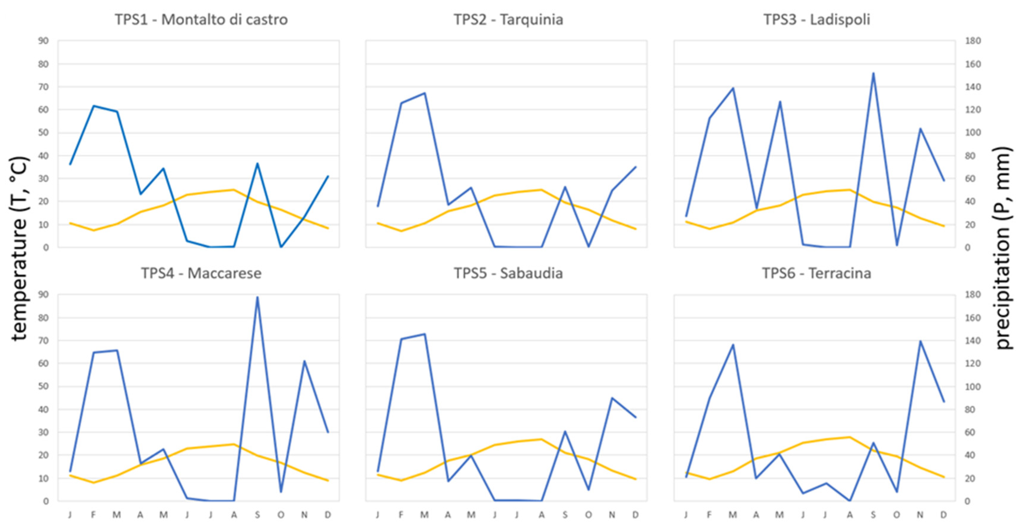
Data on temperature and precipitation in proximity to the surveyed coastal wetlands were obtained from six coastal meteorological (thermo-pluviometric) stations (Figure 1).
An ordination through principal component analysis (PCA) was performed by using all the physico-chemical descriptors to observe eventual differences in water quality amongst the investigated temporary ponds.
Furthermore, temperature and precipitation data from the closest stations were downloaded to assess the relationship between the thermo-pluviometric diagrams and pond size variation.
2.2. Image Processing and Analysis
Image processing and analysis were performed using ESRI’s ArcGIS 10.1 software. Spatial data from multiple open-access databases were collected to gather information about the surrounding area of all the ponds detected within the coastal area of Latium. Data on the lithology and land cover (Corine Land Cover) were downloaded from SINAnet.ispraambiente.it (accessed on 26 January 2020). By applying the intersect geoprocessing tool available on ArcGIS, information on soil type and land cover was assigned to each pond. Moreover, locations of roads, railways, airports, and urban areas were downloaded from OpenStreetMap.org (accessed on 7 February 2020), and the proximity analysis tools of ESRI’s ArcMap were used to assess which of these landscape elements may represent the main physical anthropogenic disturbances threatening coastal ponds in central Italy.
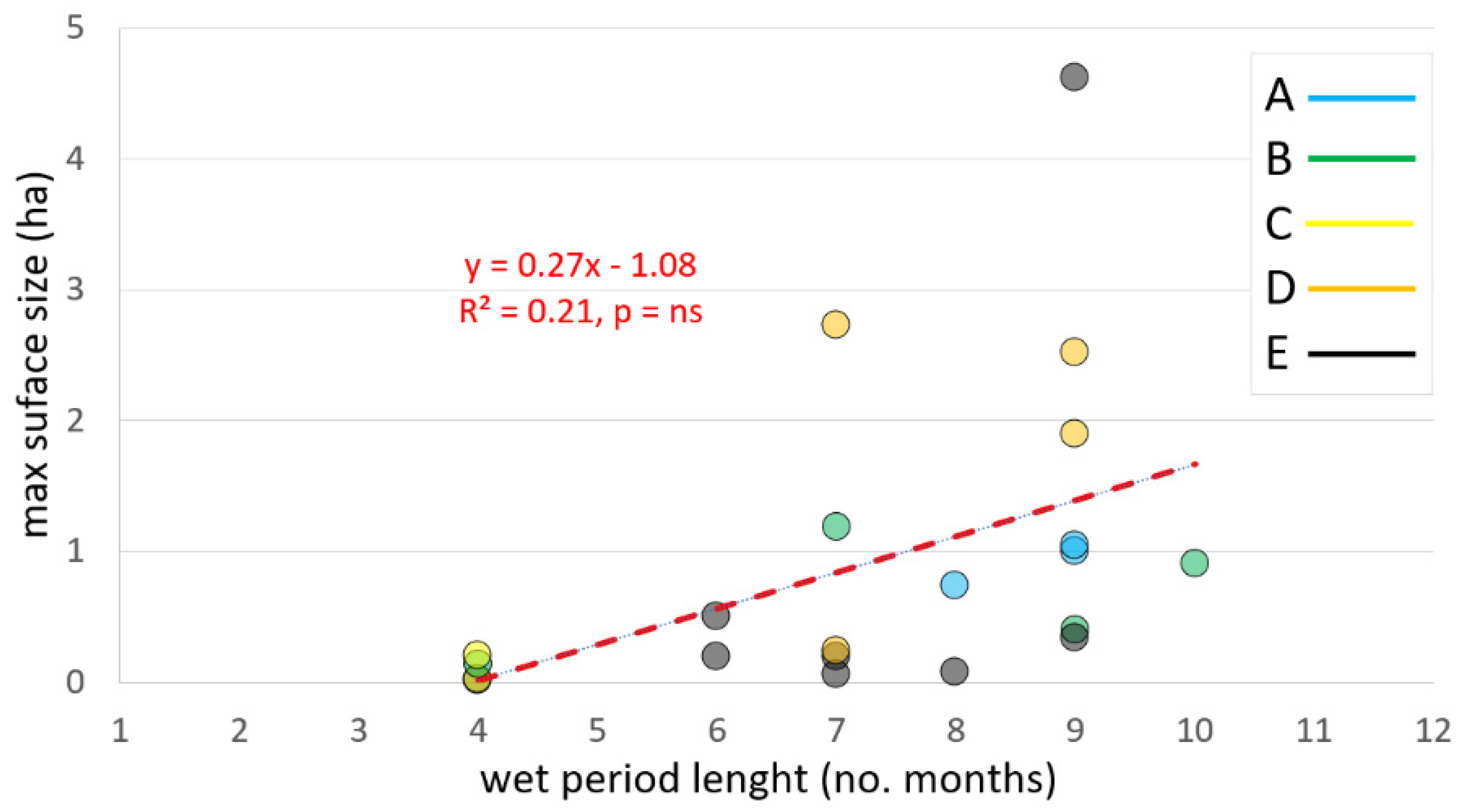
All aerial images of the monitored temporary ponds were georeferenced using an average of six ground control points. After georeferencing, UAV images were visually interpreted to outline polygon features of the ponds’ shape. In this way, it was possible to estimate the ponds’ size with the Calculate Geometry tool and to evaluate the change in the surface size of the temporary water bodies over time. In particular, a correlation analysis was performed to evaluate the relationship between the wet period length (expressed by the number of months) and the largest surface size (in ha) of the monitored coastal ponds.
3. Results
This case study conducted a census of 137 permanent and temporary natural ponds, which are often doomed to disappear due to intrinsic factors such as their scattered and isolated distribution, as well as extrinsic ones such as urban development.
Further analysis demonstrated that the most frequent threats in close proximity to the surveyed ponds were roads, especially walking paths and residential roads (Figure 2), which is consistent with the results from previous studies [42]. Indeed, increasingly accelerated urbanisation based on housing or/and road development projects has consequently led to the extinction of numerous ponds in the Latium area.
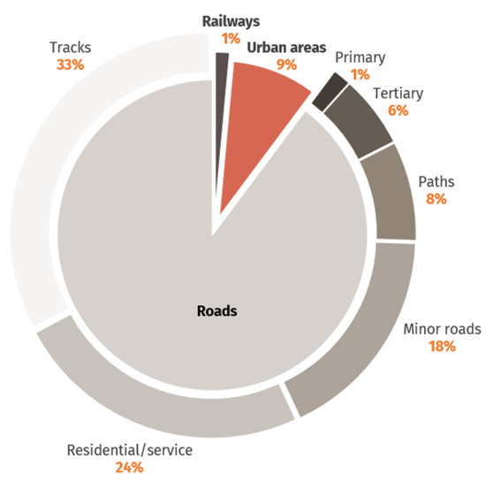
Figure 2.
Relative abundance of the fundamental stressors to the detected coastal ponds. Due to their substantial differences, the various road types are made explicit (outer ring).
In addition, most of the ponds located in non-natural areas are subject to intense anthropogenic activities, such as artificial surfaces, agricultural land, and pastures (Figure 3). Water drawn from the ponds is used for various purposes, such as the irrigation of agricultural land, the watering of livestock, and domestic use.
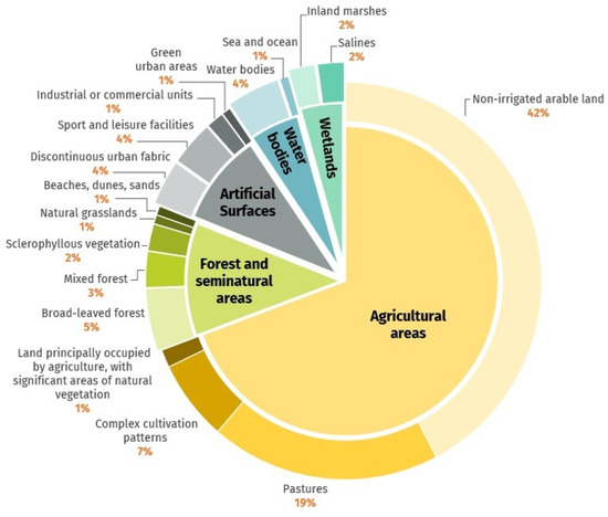
Figure 3.
Frequency of land cover types with the occurring coastal ponds. Inner circle: level 1 Corine Land Cover classes. Outer ring: level 3 Corine Land Cover classes.
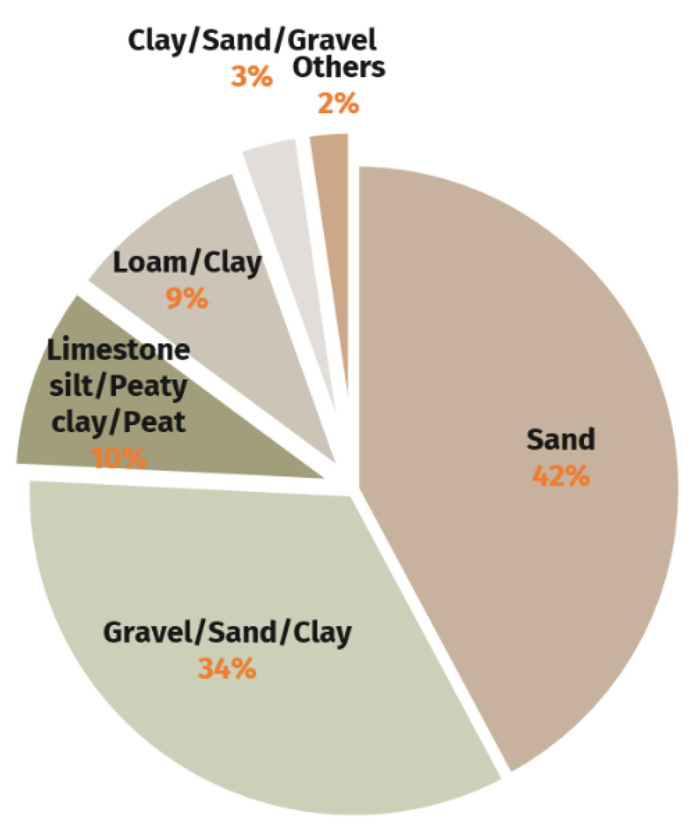
The last part of this case study concerned the several types of substrata likely to give rise to pools. The majority of the investigated ponds occurred on water-permeable soils (Figure 4) on account of their contiguity with the sea.
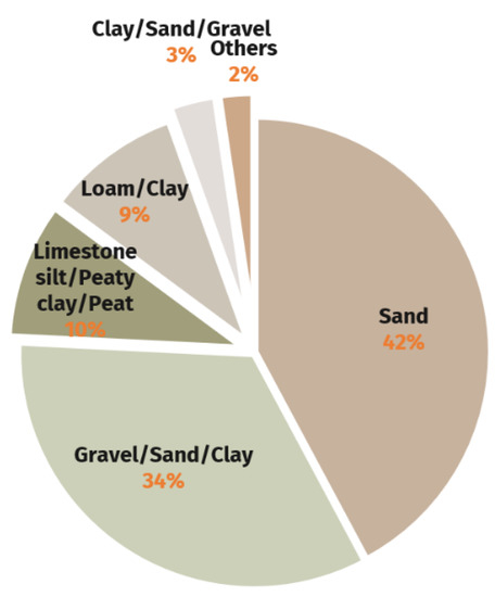
Figure 4.
Frequency of lithological types of soil across the surveyed ponds.
The census carried out in this study highlighted the presence of 137 coastal wetlands, 53 of which were identified as temporary pools (Figure 1), where three types of habitats listed in the Habitat Directive were observed: 3120 (Oligotrophic waters containing very few minerals, generally on sandy soils of the West Mediterranean, with Isoëtes spp.), 3130 (Oligotrophic to mesotrophic standing waters with vegetation of the Littorelletea uniflorae and/or the Isoëto-Nanojuncetea communities) and 3170* (Mediterranean temporary pond, MTP), the latter being considered a priority habitat from a management and conservation viewpoint.
Amongst these habitats, only MTPs have been monitored over time. Due to the large size of the study area, 21 coastal MTPs were selected and monitored for 12 months in order to study both hydroperiod and surface size. These ponds have been divided into five groups as shown in Figure 1 on the basis of proximity amongst pools and land-use context: A, pastures; B, agricultural with grasses; C, protected areas/natural reserves; D, urban; E, mixed agricultural and pastures.
The surface size values and the hydroperiod duration of each pool showed a broad variability within and amongst groups for both descriptors (Figure 5).
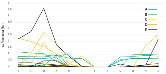
Figure 5.
Surface size variation (in ha) of the monitored Mediterranean temporary ponds during the study period. The monitored coastal ponds are grouped as indicated in Figure 1: A, pastures; B, agricultural with grasses; C, reserves; D, urban; E, mixed agricultural and pastures.
Although each MTP had its hydroperiod, July and August were always the months of drought for all the monitored temporary ponds, forming the period during which the highest T values and the lowest precipitation values were recorded (Figure 6). In some ponds, the dry period began in June, and in most of the MTPs, the dry period ended in September, although there were also cases of dry periods ending in January.

Figure 6.
Plots obtained using data of temperature (T, °C, in orange) and precipitation (P, mm, in blue) from the six coastal meteorological thermo-pluviometric stations (TPS) indicated in Figure 1.
A non-significant correlation between the hydroperiod (expressed by the number of wet months) and the maximum surface size (in ha) is shown in Figure 7.

Figure 7.
Correlation between the wet period length (months) and the max surface size (ha) of the 21 monitored coastal ponds. The monitored coastal ponds are grouped as indicated in Figure 1: A, pastures; B, agricultural with grasses; C, reserves; D, urban; E, mixed agricultural and pastures.
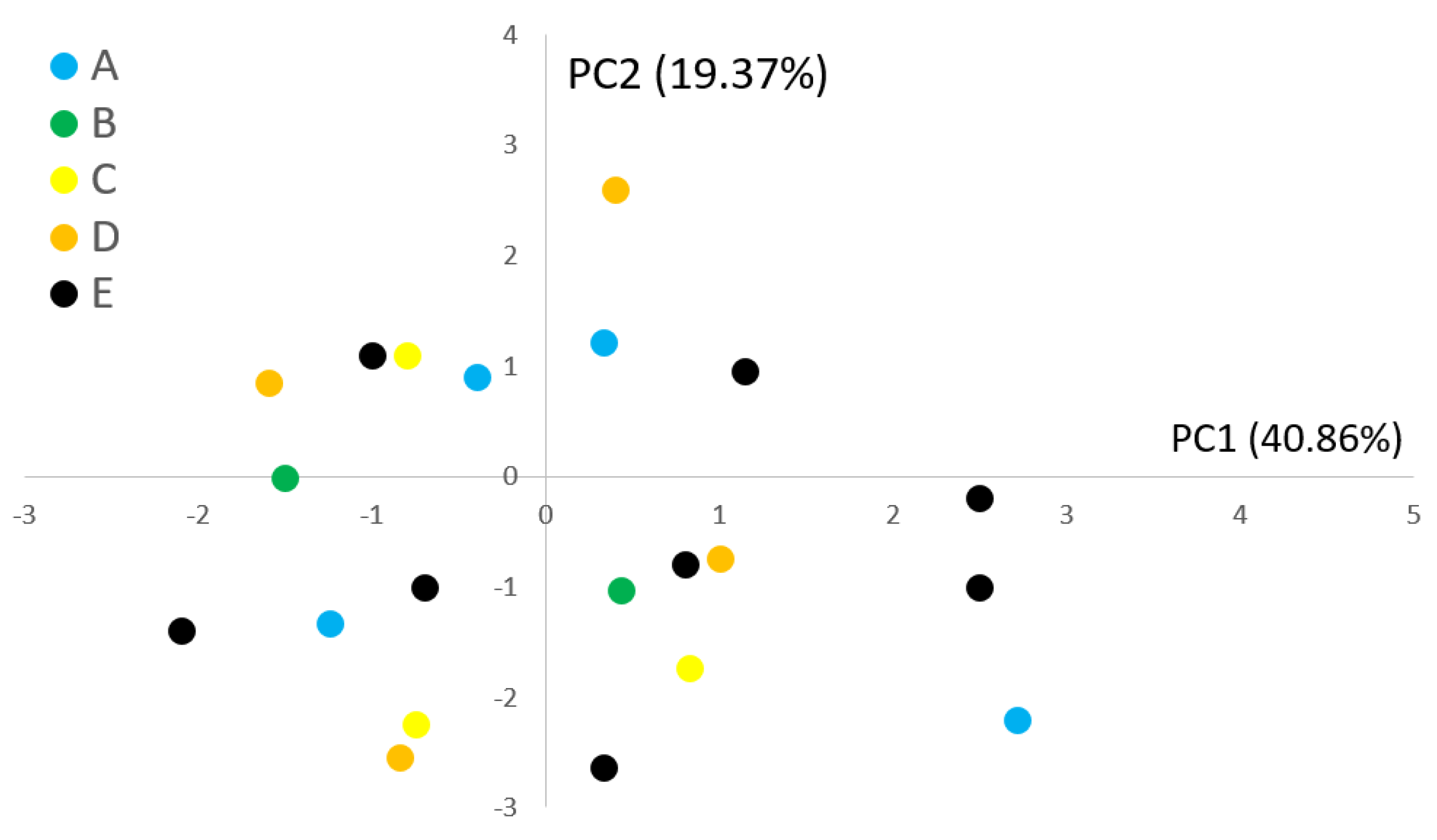
From a physico-chemical point of view as well (Table 1), the investigated MTPs showed a broad variability within each group and overlap between groups, as also described by the output of PCA ordination (Figure 8).

Table 1.
Physico-chemical measurements of the 21 monitored Mediterranean temporary ponds within the study area. Parameters in alphabetical order: EC = electric conductivity (μS/cm); NO3− = nitrate (mg/L); O2 = dissolved oxygen (mg/L, and %); PO43− = phosphate (mg/L); Tatm = atmospheric temperature (°C); Tw = water temperature (°C).
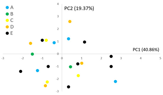
Figure 8.
Plots created using the values of the first two principal components obtained by PCA ordination of the physico-chemical data reported in Table 1 and surveyed in the 21 monitored coastal ponds grouped as indicated in Figure 1: A, pastures; B, agricultural with grasses; C, reserves; D, urban; E, mixed agricultural and pastures.
4. Discussion
The main aim of the present study was to initiate and design a monitoring plan for temporary aquatic habitats that are of naturalistic concern but that have been neglected for a long time despite their inclusion in the Habitat Directive. Indeed, detailed wetland inventories are lacking in large areas of the world (e.g., Asia, South America) [26], and overall, small wetlands are often disregarded or not identified in regions where inventories are made [43].
In this study, our inspection and monitoring activities highlighted the great importance of these habitats within the coastal water network. In fact, of all coastal water bodies, more than a third (53/137) were temporary, and these were evenly distributed within the study area. Their occurrence, from autumn to spring, allows the increased dispersion of many organisms that do not find available habitats during the dry months. Indeed, temporary ponds are often used as breeding spots for amphibians (see Introduction) because the distribution of such wetlands guarantees continuity along the entire coast and serves as an important ecological corridor for both native and alien organisms in dispersion and/or migration, such as the smooth newt Lissotriton vulgaris (observed within ponds from group C) and the non-native red swamp crayfish Procambarus clarkii (groups D and E).
From a conservational point of view, the finding of three different types of habitats listed in the main international conventions for environmental protection is significant, with particular reference to the priority habitat 3170*, which was the most abundant habitat on the entire coastline. Mediterranean temporary ponds are a peculiar type of temporary wetlands, which mainly occur around the Mediterranean basin in southern Europe and North Africa, but also in other regions with a Mediterranean climate (i.e., mild and rainy winters, hot and dry summers) [44]. Mediterranean temporary ponds in southern Europe are an EU Priority Habitat under the auspices of the Habitats Directive, and special protections apply in several Mediterranean countries [28,45]. These very shallow ponds are present only during winter and late spring and harbour several rare or threatened species of plants, amphibians, and invertebrates listed in international conventions (the Habitats Directive, the Bern Convention, and the IUCN Red List) [9]. The preservation of such habitats is also a priority of the Mediterranean Wetlands Strategy, which aims at “stopping and reversing the loss and degradation of Mediterranean wetlands as a contribution to the conservation of biodiversity and sustainable development in the region” [1].
In this study, only MTPs have been monitored over time in order to survey both hydroperiod and surface size. To collect information on occurrence and surface size, the use of UAVs was preferred to satellite images because of limitations in data availability in adverse atmospheric conditions and sensors’ spatial resolution [46]. However, the current progress of remote-sensing technologies appears promising for improving the detection and mapping of small wetland features [46,47].
Over the last decade, the use of drones for both civilian and scientific purposes has aroused growing interest, so much as to mark the beginning of a new era of remote sensing [48] in the study of the environment [49]. Indeed, drones represent a relatively risk-free and low-cost way to observe natural phenomena rapidly and systematically at high spatial and temporal resolutions [50]. For these reasons, drones have recently become a major trend in wildlife research [51,52] and management [53,54,55].
As temporary ponds are fluctuating, highly dynamic systems, well-designed sampling protocols exploiting remote-sensing systems are required to incorporate such temporal variability [56]. In this study, the use of remote-sensing techniques was necessary to describe the variation in size and hydroperiod of the investigated temporary ponds. The surface size values and hydroperiods of each pond showed a broad variability of both descriptors within and amongst groups. Moreover, our results indicate that these two descriptors are not statistically correlated, which suggests that the hydroperiod is independent of the size of the pond. When considering the physico-chemical analyses carried out on the monitored water bodies, this study shows that the ponds do not show significant differences. In particular, the hydroperiod, the size, and the physical and chemical conditions do not seem to show evident patterns related to geographical position and/or environmental conditions. Most likely, future monitoring protocols on the status of temporary pools will also have to take into account the presence of water in the subsoil and exposure to weather conditions (mostly related to wind and solar radiation).
The characteristic features of temporary ponds are their small size (generally no more than five ha large) and shallow depth (often only a few decimetres deep). Such small water volumes are subject to strong diurnal and seasonal fluctuations in abiotic parameters such as pH, oxygen, nutrients, temperature, and electrical conductivity [6,9]. Water levels also tend to vary widely between and within years, depending on climate conditions [57,58], which implies that spot measurements of water quality parameters only provide information on the current state of the wetland, sometimes neglecting significant temporal fluctuations. The timing of these measurements is therefore critically important for the outcome of the assessment. The seasonal fluctuations in abiotic conditions also result in a considerable turnover of the animal and plant communities with clear successional phases, each represented by a distinctive group of organisms [57,59,60].
The hydroperiod strongly affects the community composition since it represents the time window during which organisms must colonise, grow, and reproduce [61]. In addition, interannual differences in environmental conditions can lead to different communities than in previous inundations [57], which can play a significant role in the evaluation of ecological integrity of temporary wetland ecosystems [62,63].
5. Conclusions
Although temporary wetlands are the main water sources in (semi)arid regions and often provide habitats for unique biodiversity, monitoring programmes such as those required by the Water Framework Directive are missing to date. This is surprising since temporary ponds may be considered suitable indicators of environmental modifications related to detrimental effects caused by actual progressive climate changes.
Managing and preserving temporary wetlands and their ecosystem services means evaluating their conservation status, and the first step towards this objective is to improve knowledge of their distribution and hydrodynamism, as well as their relation to land use. Therefore, in the present study, we georeferenced all small temporary wetlands within the Tyrrhenian central Italy coastal area, evaluated their hydroperiod, and calculated their surface size variability. Moreover, the wetlands’ statuses were assessed in relation to land use and proximity to stressors by assessing the relationship between pond occurrence, lithology, and permeability.
Our main findings are that most of the surveyed ponds are in close proximity to roads and tracks, which might have significant impacts on their conservation. Furthermore, such habitats could act as models for monitoring the effects of climate change through hydroperiod assessment. However, the very dynamic hydroperiod of such water bodies leads to rapid changes in shape and size within a year, making their monitoring difficult and their mapping complicated. Indeed, the high dynamism, together with the small size of such types of ecosystems, may have hampered their extensive identification. Several temporary ponds may have been missed during the preliminary Google Earth visual inspection. Although urgently needed, no dedicated protocols are now available for the monitoring of such types of ecosystems. However, all of the above can be explained by the fact that the degree to which areas are selected for monitoring and protection is inversely proportional to their relative “mappability” [64].
Author Contributions
Conceptualisation, M.S. and M.M.; methodology, M.S., M.P., J.B. and L.B.; validation, M.S., M.P., L.B. and M.M.; formal analysis, M.S. and M.P.; investigation, M.S. and J.B.; resources, M.S.; data curation, M.S., M.P. and J.B.; writing—original draft preparation, M.S., M.P., B.J, L.B. and M.M.; writing—review and editing, M.S., M.P. and L.B.; visualisation, M.S., M.P., L.B. and M.M.; supervision, M.S., M.P. and M.M.; project administration, M.S. and M.M.; funding acquisition, M.S. All authors have read and agreed to the published version of the manuscript.
Funding
This research was funded by the grant of Excellence Departments, MIUR-Italy (ARTICOLO 1 COMMI 314-337, LEGGE 232/2016).
Institutional Review Board Statement
Not applicable.
Informed Consent Statement
Not applicable.
Data Availability Statement
The data presented in this study are available on request from the corresponding author.
Conflicts of Interest
The authors declare no conflict of interest. The funders had no role in the design of the study; in the collection, analyses, or interpretation of data; in the writing of the manuscript, or in the decision to publish the results.
References
- Ramsar, P. The Ramsar Convention Manual: A guide to the Convention on Wetlands; Ramsar Convention Secretariat: Ramsar, Iran, 1971. [Google Scholar]
- Mitsch, W.J.; Gosselink, J.G. Wetlands; John Wiley & Sons, Inc.: Hoboken, NJ, USA, 2007. [Google Scholar]
- Costanza, R.; D’Arge, R.; De Groot, R.; Farber, S.; Grasso, M.; Hannon, B.; Limburg, K.; Naeem, S.; O’Neill, R.V.; Paruelo, J.M.; et al. The value of the world’s ecosystem services and natural capital. Nature 1997, 387, 253–260. [Google Scholar] [CrossRef]
- Joyce, C. Preface: Wetland services and management. Hydrobiologia 2012, 692, 1–3. [Google Scholar] [CrossRef] [Green Version]
- Rains, M.C.; Leibowitz, S.G.; Cohen, M.J.; Creed, I.F.; Golden, H.E.; Jawitz, J.W.; Kalla, P.; Lane, C.R.; Lang, M.W.; McLaughlin, D.L. Geographically isolated wetlands are part of the hydrological landscape. Hydrol. Process. 2015, 30, 153–160. [Google Scholar] [CrossRef]
- Williams, D.D. The Biology of Temporary Waters; Oxford University Press: Oxford, UK, 2006. [Google Scholar]
- Williams, P.; Whitfield, M.; Biggs, J.; Bray, S.; Fox, G.; Nicolet, P.; Sear, D. Comparative biodiversity of rivers, streams, ditches and ponds in an agricultural landscape in Southern England. Biol. Conserv. 2004, 115, 329–341. [Google Scholar] [CrossRef]
- Biggs, J.; Nicolet, P.; Mlinaric, M.; Lalanne, T. Report of the workshop on the protection and management of Small Water Bodies. In Proceedings of the European Environmental Bureau (EEB) and the Freshwater Habitats Trust, Brussels, Belgium, 14 November 2013. [Google Scholar]
- Grillas, P.; Gauthier, P.; Yaverkovski, N.; Perennou, C. Mediterranean Temporary Pools 1; Station Biologique de la Tour du Valat: Arles, France, 2004; pp. 1–120. [Google Scholar]
- Mushet, D.M.; Euliss, N.H.; Chen, Y.; Stockwell, C.A. Complex spatial dynamics maintain northern leopard frog (lithobates pipiens) genetic diversity in a temporally varying landscape. Herpetol. Conserv. Biol. 2013, 8, 163–175. [Google Scholar]
- Paton, P.W.C. A review of vertebrate community composition in seasonal forest pools of the northeastern United States. Wetl. Ecol. Manag. 2005, 13, 235–246. [Google Scholar] [CrossRef]
- Ganesan, G.; Rainwater, K.; Gitz, D.; Hall, N.; Zartman, R.; Hudnall, W.; Smith, L. Comparison of infiltration flux in playa lakes in grassland and cropland basins, Southern High Plains of Texas. Texas Water J. 2016, 7, 25–39. [Google Scholar]
- Leibowitz, S.G.; Mushet, D.M.; Newton, W.E. Intermittent Surface Water Connectivity: Fill and Spill Vs. Fill and Merge Dynamics. Wetlands 2016, 36, 323–342. [Google Scholar] [CrossRef]
- Holgerson, M.A. Drivers of carbon dioxide and methane supersaturation in small, temporary ponds. Biogeochemistry 2015, 124, 305–318. [Google Scholar] [CrossRef]
- Zeng, T.; Arnold, W. Pesticide Photolysis in Prairie Potholes: Probing Photosensitized Processes. Environ. Sci. Technol. 2012, 47, 6735–6745. [Google Scholar] [CrossRef]
- Cohen, M.J.; Creed, I.F.; Alexander, L.; Basu, N.B.; Calhoun, A.J.K.; Craft, C.; D’Amico, E.; DeKeyser, E.; Fowler, L.; Golden, H.; et al. Do geographically isolated wetlands influence landscape functions? Proc. Natl. Acad. Sci. USA 2016, 113, 1978–1986. [Google Scholar] [CrossRef] [PubMed] [Green Version]
- Capps, K.A.; Rancatti, R.; Tomczyk, N.; Parr, T.B.; Calhoun, A.J.K.; Hunter, M. Biogeochemical Hotspots in Forested Landscapes: The Role of Vernal Pools in Denitrification and Organic Matter Processing. Ecosystems 2014, 17, 1455–1468. [Google Scholar] [CrossRef]
- Céréghino, R.; Boix, D.; Cauchie, H.-M.; Martens, K.; Oertli, B. The ecological role of ponds in a changing world. Hydrobiologia 2013, 723, 1–6. [Google Scholar] [CrossRef] [Green Version]
- Marton, J.M.; Creed, I.F.; Lewis, D.; Lane, C.; Basu, N.B.; Cohen, M.J.; Craft, C.B. Geographically Isolated Wetlands are Important Biogeochemical Reactors on the Landscape. BioScience 2015, 65, 408–418. [Google Scholar] [CrossRef] [Green Version]
- Bagella, S.; Gascón, S.; Filigheddu, R.; Cogoni, A.; Boix, D. Mediterranean Temporary Ponds: New challenges from a neglected habitat. Hydrobiologia 2016, 782, 1–10. [Google Scholar] [CrossRef]
- Nicolet, P.; Biggs, J.; Fox, G.; Hodson, M.; Reynolds, C.; Whitfield, M.; Williams, P. The wetland plant and macroinvertebrate assemblages of temporary ponds in England and Wales. Biol. Conserv. 2004, 120, 261–278. [Google Scholar] [CrossRef]
- Rhazi, L.; Grillas, P.; Saber, E.-R.; Rhazi, M.; Brendonck, L.; Waterkeyn, A. Vegetation of Mediterranean temporary pools: A fading jewel? Hydrobiologia 2011, 689, 23–36. [Google Scholar] [CrossRef]
- Euliss, N.H.; Mushet, D.M. Impacts of water development on aquatic macroinvertebrates, amphibians, and plants in wetlands of a semi-arid landscape. Aquat. Ecosyst. Health Manag. 2004, 7, 73–84. [Google Scholar] [CrossRef] [Green Version]
- Collins, S.; Heintzman, L.; Starr, S.; Wright, C.; Henebry, G.; McIntyre, N. Hydrological dynamics of temporary wetlands in the southern Great Plains as a function of surrounding land use. J. Arid. Environ. 2014, 109, 6–14. [Google Scholar] [CrossRef]
- Bouahim, S.; Rhazi, L.; Ernoul, L.; Mathevet, R.; Amami, B.; Er-Riyahi, S.; Muller, S.D.; Grillas, P. Combining vulnerability analysis and perceptions of ecosystem services in sensitive landscapes: A case from western Moroccan temporary wetlands. J. Nat. Conserv. 2015, 27, 1–9. [Google Scholar] [CrossRef]
- Calhoun, A.J.; Mushet, D.M.; Bell, K.; Boix, D.; Fitzsimons, J.; Isselin-Nondedeu, F. Temporary wetlands: Challenges and solutions to conserving a ‘disappearing’ ecosystem. Biol. Conserv. 2017, 211, 3–11. [Google Scholar] [CrossRef]
- Rahel, F.J.; Olden, J.D. Assessing the Effects of Climate Change on Aquatic Invasive Species. Conserv. Biol. 2008, 22, 521–533. [Google Scholar] [CrossRef]
- Zacharias, I.; Zamparas, M. Mediterranean temporary ponds. A disappearing ecosystem. Biodivers. Conserv. 2010, 19, 3827–3834. [Google Scholar] [CrossRef]
- Mushet, D.M.; Calhoun, A.J.K.; Alexander, L.C.; Cohen, M.J.; DeKeyser, E.S.; Fowler, L.; Lane, C.; Lang, M.; Rains, M.; Walls, S. Geographically Isolated Wetlands: Rethinking a Misnomer. Wetlands 2015, 35, 423–431. [Google Scholar] [CrossRef] [Green Version]
- Boulton, A.J.; Ekebom, J.; Gíslason, G.M. Integrating ecosystem services into conservation strategies for freshwater and marine habitats: A review. Aquat. Conserv. Mar. Freshw. Ecosyst. 2016, 26, 963–985. [Google Scholar] [CrossRef] [Green Version]
- Turner, R.K.; Morse-Jones, S.; Fisher, B. Ecosystem valuation. Ann. N. Y. Acad. Sci. 2010, 1185, 79–101. [Google Scholar] [CrossRef] [PubMed]
- Chrobak, G.; Kowalczyk, T.; Fischer, T.B.; Szewrański, S.; Chrobak, K.; Kazak, J.K. Ecological state evaluation of lake ecosystems revisited: Latent variables with kSVM algorithm approach for assessment automatization and data comprehension. Ecol. Indic. 2021, 125, 107567. [Google Scholar] [CrossRef]
- Xia, Z.; Guo, X.; Chen, R. Automatic extraction of aquaculture ponds based on Google Earth Engine. Ocean Coast. Manag. 2020, 198, 105348. [Google Scholar] [CrossRef]
- Ottinger, M.; Clauss, K.; Kuenzer, C. Large-Scale Assessment of Coastal Aquaculture Ponds with Sentinel-1 Time Series Data. Remote Sens. 2017, 9, 440. [Google Scholar] [CrossRef] [Green Version]
- Doña, C.; Morant, D.; Picazo, A.; Rochera, C.; Sánchez, J.; Camacho, A. Estimation of Water Coverage in Permanent and Temporary Shallow Lakes and Wetlands by Combining Remote Sensing Techniques and Genetic Programming. Application to the Mediterranean Basin of the Iberian Peninsula. Remote Sens. 2021, 13, 652. [Google Scholar] [CrossRef]
- Perrone, M.; Scalici, M.; Conti, L.; Moravec, D.; Kropáček, J.; Sighicelli, M.; Lecce, F.; Malavasi, M. Water Mixing Conditions Influence Sentinel-2 Monitoring of Chlorophyll Content in Monomictic Lakes. Remote Sens. 2021, 13, 2699. [Google Scholar] [CrossRef]
- Broeck, M.V.D.; Waterkeyn, A.; Rhazi, L.; Grillas, P.; Brendonck, L. Assessing the ecological integrity of endorheic wetlands, with focus on Mediterranean temporary ponds. Ecol. Indic. 2015, 54, 1–11. [Google Scholar] [CrossRef]
- Meter, R.; Bailey, L.L.; Grant, E.H.C. Methods for estimating the amount of vernal pool habitat in the northeastern United States. Wetlands 2008, 28, 585–593. [Google Scholar] [CrossRef]
- Wu, J.; Zeng, S.; Yang, L.; Ren, Y.; Xia, J. Spatiotemporal Characteristics of the Water Quality and Its Multiscale Relationship with Land Use in the Yangtze River Basin. Remote Sens. 2021, 13, 3309. [Google Scholar] [CrossRef]
- López, J.J.; Mulero-Pázmány, M. Drones for Conservation in Protected Areas: Present and Future. Drones 2019, 3, 10. [Google Scholar] [CrossRef] [Green Version]
- Klemas, V.V. Coastal and Environmental Remote Sensing from Unmanned Aerial Vehicles: An Overview. J. Coast. Res. 2015, 315, 1260–1267. [Google Scholar] [CrossRef] [Green Version]
- Zacharias, I.; Dimitriou, E.; Dekker, A.; Dorsman, E. Overview of temporary ponds in the Mediterranean region: Threats, management and conservation issues. J. Environ. Biol. 2007, 28, 1–9. [Google Scholar] [PubMed]
- Junk, W.J.; An, S.; Finlayson, C.M.; Gopal, B.; Květ, J.; Mitchell, S.A.; Mitsch, W.J.; Robarts, R.D. Current state of knowledge regarding the world’s wetlands and their future under global climate change: A synthesis. Aquat. Sci. 2012, 75, 151–167. [Google Scholar] [CrossRef] [Green Version]
- Grillas, P.; Waterkeyn, A.; Rhazi, L.; Brendonck, L. Bassès temporales mediterrànies. LIFE BASSES: Gestió I conservació a Menroca. In Mediterranean Temporary Ponds around the World; Collecciò Recerca, 15; Fraga, I., Arguimbau, P., Clarisó, I.E., Pons, E., Eds.; Institut Menorquí d’Estudis: Mahón, Spain, 2010. [Google Scholar]
- Bagella, S.; Caria, M.C.; Farris, E.; Filigheddu, R. Issues related to the classification of Mediterranean temporary wet habitats according with the European Union Habitats Directive. Fitosociologia 2007, 44, 245–249. [Google Scholar]
- Tiner, R.W.; Lang, M.W.; Klemas, V.V. Remote Sensing of Wetlands: Applications and Advances; CRC Press: Boca Raton, FL, USA, 2015. [Google Scholar]
- Wu, Q.; Lane, C.R. Delineation and Quantification of Wetland Depressions in the Prairie Pothole Region of North Dakota. Wetlands 2016, 36, 215–227. [Google Scholar] [CrossRef]
- Melesse, A.M.; Weng, Q.; Thenkabail, P.S.; Senay, G.B. Remote Sensing Sensors and Applications in Environmental Resources Mapping and Modelling. Sensors 2007, 7, 3209–3241. [Google Scholar] [CrossRef] [PubMed] [Green Version]
- Whitehead, K.; Moorman, B.; Wainstein, P. Measuring daily surface elevation and velocity variations across a polythermal arctic glacier using ground-based photogrammetry. J. Glaciol. 2014, 60, 1208–1220. [Google Scholar] [CrossRef] [Green Version]
- Rodríguez, A.; Negro, J.J.; Mulero-Pázmány, M.; Rodríguez, C.; Hernández-Pliego, J.; Bustamante, J. The Eye in the Sky: Combined Use of Unmanned Aerial Systems and GPS Data Loggers for Ecological Research and Conservation of Small Birds. PLoS ONE 2012, 7, e50336. [Google Scholar] [CrossRef] [Green Version]
- Linchant, J.; Lisein, J.; Semeki, J.; Lejeune, P.; Vermeulen, C. Are unmanned aircraft systems (UASs) the future of wildlife monitoring? A review of accomplishments and challenges. Mammal Rev. 2015, 45, 239–252. [Google Scholar] [CrossRef]
- Christie, K.S.; Gilbert, S.L.; Brown, C.L.; Hatfield, M.; Hanson, L. Unmanned aircraft systems in wildlife research: Current and future applications of a transformative technology. Front. Ecol. Environ. 2016, 14, 241–251. [Google Scholar] [CrossRef]
- Koh, L.P.; Wich, S.A. Dawn of Drone Ecology: Low-Cost Autonomous Aerial Vehicles for Conservation. Trop. Conserv. Sci. 2012, 5, 121–132. [Google Scholar] [CrossRef] [Green Version]
- Mulero-Pázmány, M.; Stolper, R.; Van Essen, L.D.; Negro, J.; Sassen, T. Remotely Piloted Aircraft Systems as a Rhinoceros Anti-Poaching Tool in Africa. PLoS ONE 2014, 9, e83873. [Google Scholar] [CrossRef] [Green Version]
- Chabot, D.; Bird, D.M. Wildlife research and management methods in the 21st century: Where do unmanned aircraft fit in? J. Unmanned Veh. Syst. 2015, 3, 137–155. [Google Scholar] [CrossRef] [Green Version]
- Brock, M.A.; Nielsen, D.L.; Shiel, R.J.; Green, J.D.; Langley, J.D. Drought and aquatic community resilience: The role of eggs and seeds in sediments of temporary wetlands. Freshw. Biol. 2003, 48, 1207–1218. [Google Scholar] [CrossRef]
- Waterkeyn, A.; Grillas, P.; De Roeck, E.R.M.; Boven, L.; Brendonck, L. Assemblage structure and dynamics of large branchiopods in Mediterranean temporary wetlands: Patterns and processes. Freshw. Biol. 2009, 54, 1256–1270. [Google Scholar] [CrossRef]
- Sahuquillo, M.; Miracle, M.R.; Morata, S.M.; Vicente, E. Nutrient dynamics in water and sediment of Mediterranean ponds across a wide hydroperiod gradient. Limnologica 2012, 42, 282–290. [Google Scholar] [CrossRef]
- Gascón, S. Variability of benthic assemblages in relation to the hydrological pattern in Mediterranean salt marshes (Emporda wetlands, NE Iberian Peninsula). Arch. Hydrobiol. 2005, 163, 163–181. [Google Scholar] [CrossRef]
- Vanschoenwinkel, B.; Waterkeyn, A.; Jocque, M.; Boven, L.; Seaman, M.; Brendonck, L. Species sorting in space and time—the impact of disturbance regime on community assembly in a temporary pool metacommunity. J. N. Am. Benthol. Soc. 2010, 29, 1267–1278. [Google Scholar] [CrossRef]
- Vanschoenwinkel, B.; Hulsmans, A.; De Roeck, E.; De Vries, C.; Seaman, M.; Brendonck, L. Community structure in temporary freshwater pools: Disentangling the effects of habitat size and hydroregime. Freshw. Biol. 2009, 54, 1487–1500. [Google Scholar] [CrossRef]
- Bornette, G.; Puijalon, S. Response of aquatic plants to abiotic factors: A review. Aquat. Sci. 2010, 73, 1–14. [Google Scholar] [CrossRef]
- Bouahim, S.; Rhazi, L.; Amami, B.; Waterkeyn, A.; Rhazi, M.; Saber, E.-R.; Zouahri, A.; Broeck, M.V.D.; Muller, S.D.; Brendonck, L.; et al. Unravelling the impact of anthropogenic pressure on plant communities in Mediterranean temporary ponds. Mar. Freshw. Res. 2014, 65, 918–929. [Google Scholar] [CrossRef]
- Malavasi, M. The map of biodiversity mapping. Biol. Conserv. 2020, 252, 108843. [Google Scholar] [CrossRef]


Publisher’s Note: MDPI stays neutral with regard to jurisdictional claims in published maps and institutional affiliations. |
© 2021 by the authors. Licensee MDPI, Basel, Switzerland. This article is an open access article distributed under the terms and conditions of the Creative Commons Attribution (CC BY) license (https://creativecommons.org/licenses/by/4.0/).