
The Integration of Earthwork Design Review and Planning Using UAV-Based Point Cloud and BIM


Abstract
:Featured Application
Abstract
1. Introduction
2. Literature Review
2.1. Overview of Design Review and Need of UAV
2.2. Overview of UAVs and Benefits
2.3. Factors That Affect UAV Accuracy
2.4. Design Review for Earthwork
2.5. Integration of Point Cloud and BIM
3. Study Area and Methods
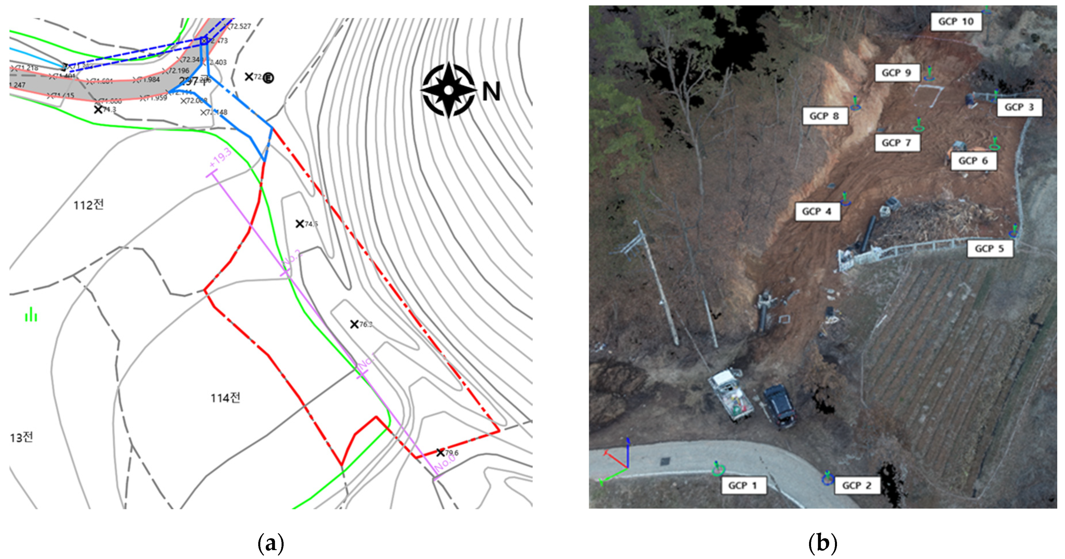
3.1. Study Area
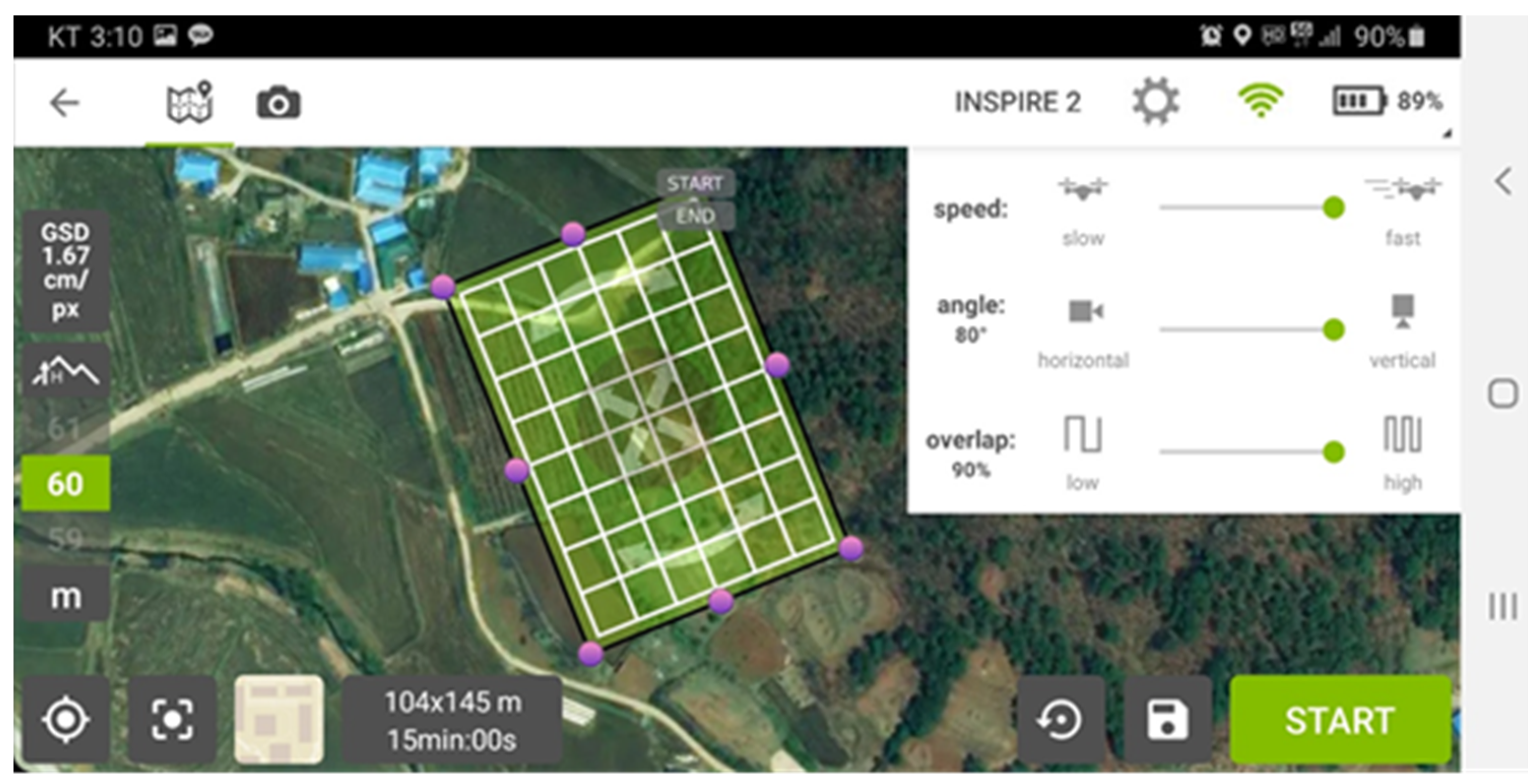
3.2. Earthwork Design and Data Acquisition
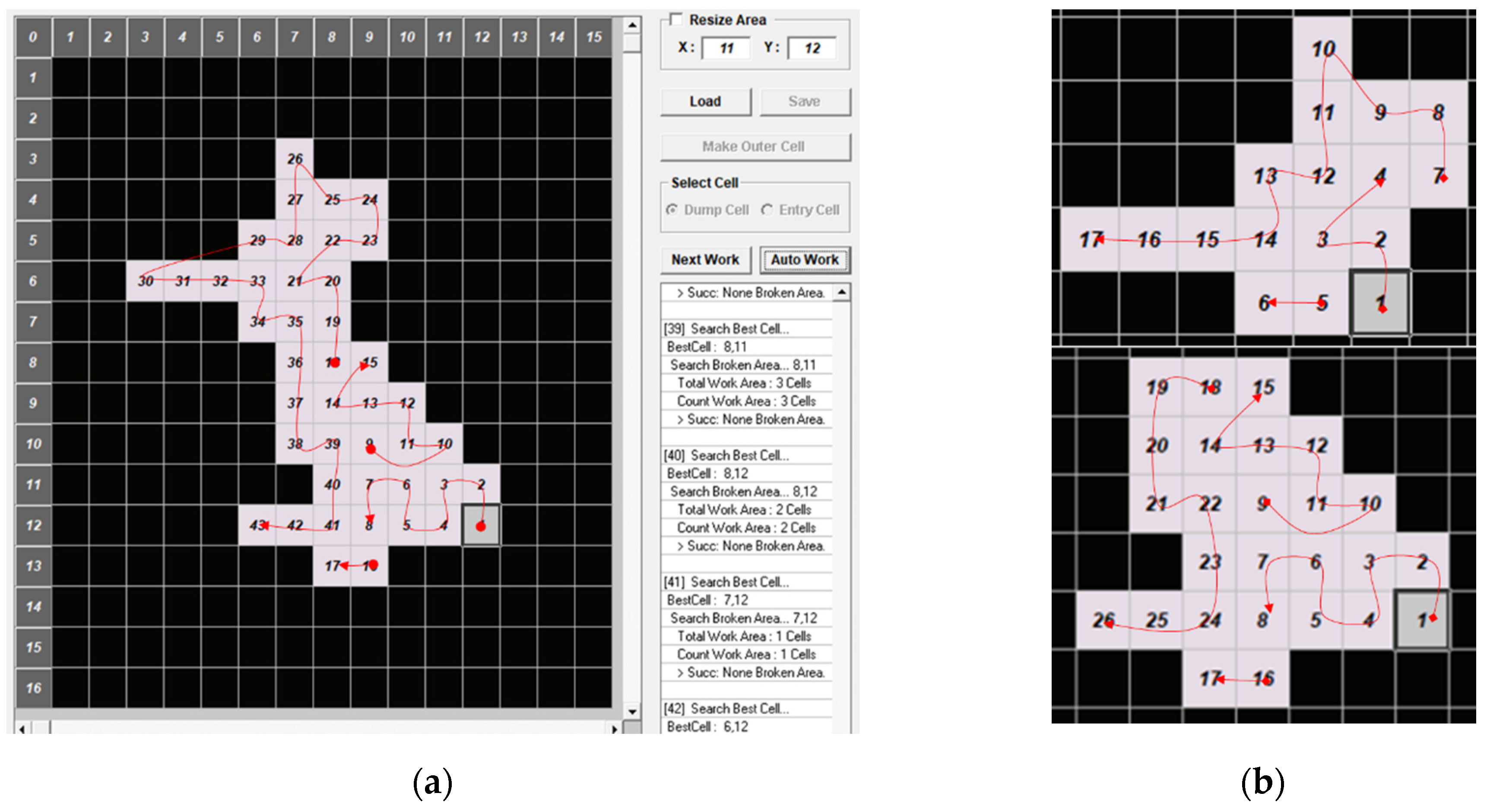
3.3. Integration of Earthwork Design Review and Planning
4. Results
4.1. Earthwork Design Review
4.2. Integrating Earthwork Design and Planning
5. Discussions
6. Conclusions
Author Contributions
Funding
Institutional Review Board Statement
Informed Consent Statement
Data Availability Statement
Acknowledgments
Conflicts of Interest
References
- Kim, J.; Lee, D.; Seo, J. Task Planning Strategy and Path Similarity Analysis for an Autonomous Excavator. Autom. Constr. 2020, 112, 103108. [Google Scholar] [CrossRef]
- FHWA Maintenance of Drainage Features for Safety. Available online: https://safety.fhwa.dot.gov/local_rural/training/fhwasa09024/ (accessed on 18 January 2021).
- Vaze, J.; Teng, J.; Spencer, G. Impact of DEM Accuracy and Resolution on Topographic Indices. Environ. Model. Softw. 2010, 25, 1086–1098. [Google Scholar] [CrossRef]
- Siebert, S.; Teizer, J. Mobile 3D Mapping for Surveying Earthwork Projects Using an Unmanned Aerial Vehicle (UAV) System. Autom. Constr. 2014, 41, 1–14. [Google Scholar] [CrossRef]
- Kwon, S.; Park, J.W.; Moon, D.; Jung, S.; Park, H. Smart Merging Method for Hybrid Point Cloud Data Using UAV and LIDAR in Earthwork Construction. Procedia Eng. 2017, 196, 21–28. [Google Scholar] [CrossRef]
- Kim, S.-K.; Seo, J.; Russell, J.S. Intelligent Navigation Strategies for an Automated Earthwork System. Autom. Constr. 2012, 21, 132–147. [Google Scholar] [CrossRef]
- Goessens, S.; Mueller, C.; Latteur, P. Feasibility Study for Drone-Based Masonry Construction of Real-Scale Structures. Autom. Constr. 2018, 94, 458–480. [Google Scholar] [CrossRef]
- Raza, H.; Tanoli, W.; Lee, S.; Seo, J. Flexible Earthwork BIM Module Framework for Road Project. In Proceedings of the 34th International Symposium on Automation and Robotics in Construction (ISARC), Taipei, Taiwan, 28 June–1 July 2017; pp. 410–415. [Google Scholar] [CrossRef] [Green Version]
- Akgul, M.; Yurtseven, H.; Gulci, S.; Akay, A.E. Evaluation of UAV- and GNSS-Based DEMs for Earthwork Volume. Arab. J. Sci. Eng. 2018, 43, 1893–1909. [Google Scholar] [CrossRef]
- Li, J.; Hou, L.; Wang, X.; Wang, J.; Guo, J.; Zhang, S.; Jiao, Y. A Project-Based Quantification of BIM Benefits. Int. J. Adv. Robot. Syst. 2014, 11, 123. [Google Scholar] [CrossRef]
- Raeva, P.L.; Filipova, S.L.; Filipov, D.G. Volume computation of a stockpile—A study case comparing gps and uav measurements in an open pit quarry. Int. Arch. Photogramm. Remote Sens. Spat. Inf. Sci. 2016, XLI-B1, 999–1004. [Google Scholar] [CrossRef] [Green Version]
- Ameri, B.; Meger, D.; Power, K.; Gao, Y. Uas Applications: Disaster & Emergency Management. In Proceedings of the ASPRS 2009 Annual Conference, Baltimore, MD, USA, 9–13 March 2009; pp. 45–55. [Google Scholar]
- Saari, H.; Pellikka, I.; Pesonen, L.; Tuominen, S.; Heikkilä, J.; Holmlund, C.; Mäkynen, J.; Ojala, K.; Antila, T. Unmanned Aerial Vehicle (UAV) Operated Spectral Camera System for Forest and Agriculture Applications. Remote Sens. Agric. Ecosyst. Hydrol. XIII 2011, 8174, 81740H. [Google Scholar] [CrossRef]
- Duque, L.; Seo, J.; Wacker, J. Bridge Deterioration Quantification Protocol Using UAV. J. Bridge Eng. 2018, 23, 1–12. [Google Scholar] [CrossRef]
- Chen, S.; Laefer, D.F.; Mangina, E.; Zolanvari, S.M.I.; Byrne, J. UAV Bridge Inspection through Evaluated 3D Reconstructions. J. Bridge Eng. 2019, 24, 1–15. [Google Scholar] [CrossRef] [Green Version]
- Tan, Y.; Li, Y. UAV Photogrammetry-Based 3D Road Distress Detection. ISPRS Int. J. Geo-Inf. 2019, 8, 409. [Google Scholar] [CrossRef] [Green Version]
- D’Oleire-Oltmanns, S.; Marzolff, I.; Peter, K.D.; Ries, J.B. Unmanned Aerial Vehicle (UAV) for Monitoring Soil Erosion in Morocco. Remote Sens. 2012, 4, 3390–3416. [Google Scholar] [CrossRef] [Green Version]
- Xie, F.; Lin, Z.; Gui, D.; Lin, H. Study on Construction of 3D Building Based on Uav Images. ISPRS-Int. Arch. Photogramm. Remote Sens. Spat. Inf. Sci. 2012, XXXIX-B1, 469–473. [Google Scholar] [CrossRef] [Green Version]
- Cheng, J.C.P.; Deng, Y. An Integrated BIM-GIS Framework for Utility Information Management and Analyses. Comput. Civ. Eng. 2015, 2015, 667–674. [Google Scholar] [CrossRef]
- Julge, K.; Ellmann, A.; Köök, R. Unmanned Aerial Vehicle Surveying for Monitoring Road Construction Earthworks. Balt. J. Road Bridge Eng. 2019, 14, 1–17. [Google Scholar] [CrossRef]
- Hudzietz, B.P.; Saripalli, S. An Experimental Evaluation of 3D Terrain Mapping With an Autonomous Helicopter. ISPRS-Int. Arch. Photogramm. Remote Sens. Spat. Inf. Sci. 2012, XXXVIII-1/C22, 137–142. [Google Scholar] [CrossRef] [Green Version]
- Piras, M.; Taddia, G.; Forno, M.G.; Gattiglio, M.; Aicardi, I.; Dabove, P.; Russo, S.L.; Lingua, A. Detailed Geological Mapping in Mountain Areas Using an Unmanned Aerial Vehicle: Application to the Rodoretto Valley, NW Italian Alps. Geomat. Nat. Hazards Risk 2017, 8, 137–149. [Google Scholar] [CrossRef]
- Pi, Y.; Nath, N.D.; Behzadan, A.H. Convolutional Neural Networks for Object Detection in Aerial Imagery for Disaster Response and Recovery. Adv. Eng. Inform. 2020, 43, 101009. [Google Scholar] [CrossRef]
- NGII Integrated Map. Available online: http://map.ngii.go.kr/ms/map/NlipMap.do (accessed on 11 March 2021).
- DJI. DJI’s Inspire 2. Available online: https://www.dji.com/inspire-2 (accessed on 11 March 2021).
- DJI. Zenmuse X4S. Available online: https://www.dji.com/zenmuse-x4s (accessed on 11 March 2021).
- Pix4D. Pix4Dmapper. Available online: https://www.pix4d.com/product/pix4dmapper-photogrammetry-software (accessed on 11 March 2021).
- Pix4D Ground Control Points: Why Are They Important? Available online: /blog/why-ground-control-points-important (accessed on 11 March 2021).
- Korea Legislation Research Institute Act on Promotion of Utilization of Drones and Creation of Infrastructure Therefor. Available online: https://elaw.klri.re.kr/kor_service/lawView.do?hseq=53139&lang=ENG (accessed on 11 March 2021).
- Tomaštík, J.; Mokroš, M.; Surový, P.; Grznárová, A.; Merganič, J. UAV RTK/PPK Method—An Optimal Solution for Mapping Inaccessible Forested Areas? Remote Sens. 2019, 11, 721. [Google Scholar] [CrossRef] [Green Version]


| GCPs | Northing (m) | Easting (m) | Elevation (m) |
|---|---|---|---|
| 1 | 354,794.355 | 211,658.751 | 72.34 |
| 2 | 354,788.336 | 211,653.043 | 71.959 |
| 3 | 354,736.735 | 211,687.548 | 75.175 |
| 4 | 354,723.373 | 211,703.816 | 74.206 |
| 5 | 354,768.343 | 211,679.642 | 74.979 |
| 6 | 354,756.908 | 211,664.313 | 73.835 |
| 7 | 354,747.569 | 211,677.045 | 75.791 |
| 8 | 354,757.486 | 211,692.782 | 78.496 |
| 9 | 354,740.068 | 211,698.525 | 75.993 |
| 10 | 354,751.823 | 211,686.751 | 75.958 |
| Classification | Cut (m3) | Fill (m3) | Net (m3) |
|---|---|---|---|
| Phase 1 | 58.77 | 138.096 | 79.326 |
| Phase 2 | 205.74 | 139.491 | 66.249 |
| Access road | 0.86 | 17.901 | 17.041 |
| Slope area | 165.6 | 25.263 | 140.337 |
| Total | 430.97 | 320.751 | 110.219 |
Publisher’s Note: MDPI stays neutral with regard to jurisdictional claims in published maps and institutional affiliations. |
© 2021 by the author. Licensee MDPI, Basel, Switzerland. This article is an open access article distributed under the terms and conditions of the Creative Commons Attribution (CC BY) license (https://creativecommons.org/licenses/by/4.0/).
Share and Cite
Kim, J.; Lee, S.; Seo, J.; Lee, D.-E.; Choi, H.S. The Integration of Earthwork Design Review and Planning Using UAV-Based Point Cloud and BIM. Appl. Sci. 2021, 11, 3435. https://doi.org/10.3390/app11083435
Kim J, Lee S, Seo J, Lee D-E, Choi HS. The Integration of Earthwork Design Review and Planning Using UAV-Based Point Cloud and BIM. Applied Sciences. 2021; 11(8):3435. https://doi.org/10.3390/app11083435
Chicago/Turabian StyleKim, Jeonghwan, Soomin Lee, Jongwon Seo, Dong-Eun Lee, and Hee Seon Choi. 2021. "The Integration of Earthwork Design Review and Planning Using UAV-Based Point Cloud and BIM" Applied Sciences 11, no. 8: 3435. https://doi.org/10.3390/app11083435
APA StyleKim, J., Lee, S., Seo, J., Lee, D.-E., & Choi, H. S. (2021). The Integration of Earthwork Design Review and Planning Using UAV-Based Point Cloud and BIM. Applied Sciences, 11(8), 3435. https://doi.org/10.3390/app11083435