
Technological Development and Application of Photo and Video Theodolites


Abstract
1. Introduction
2. Technological Development
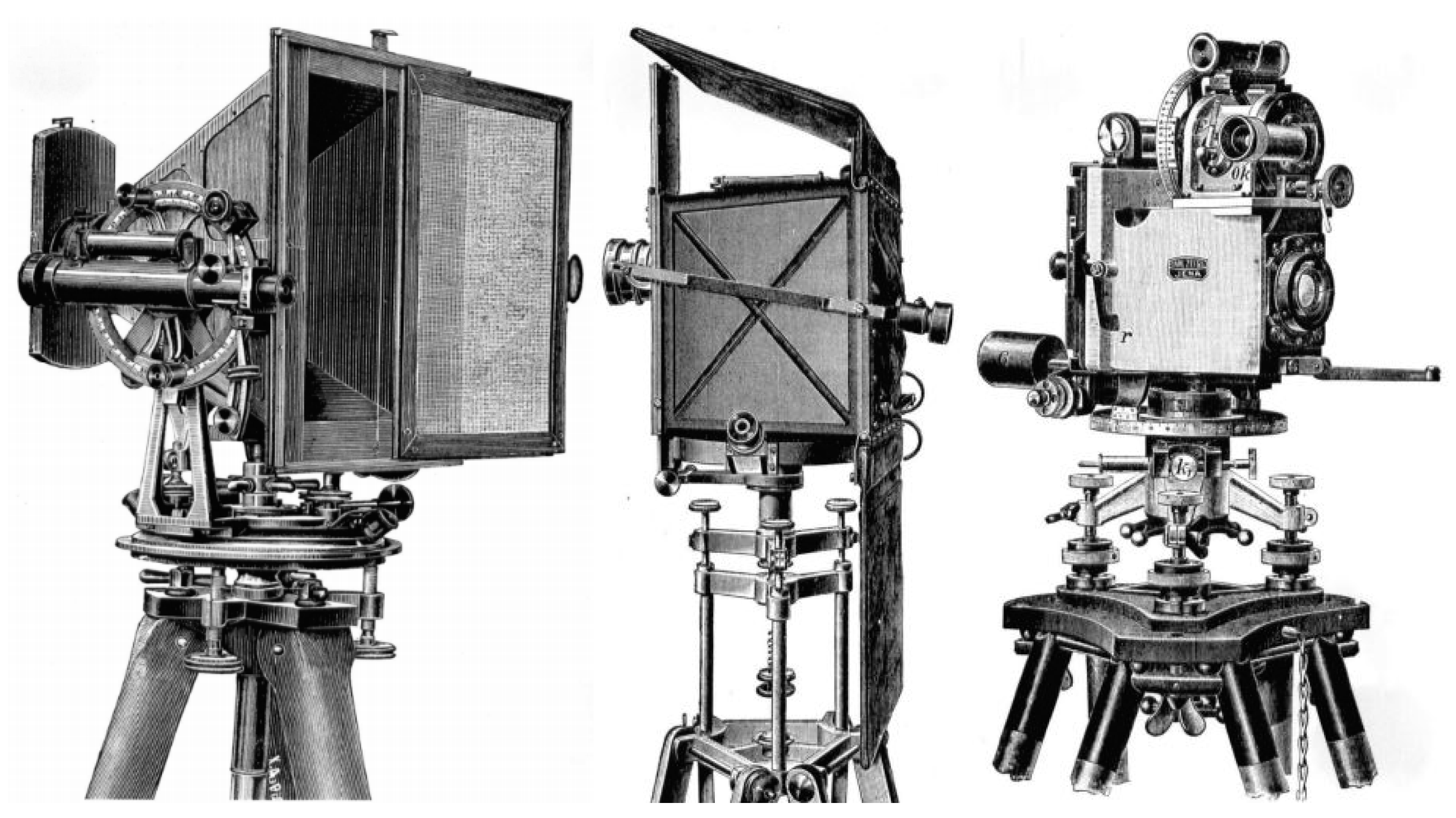
2.1. Development until 1940
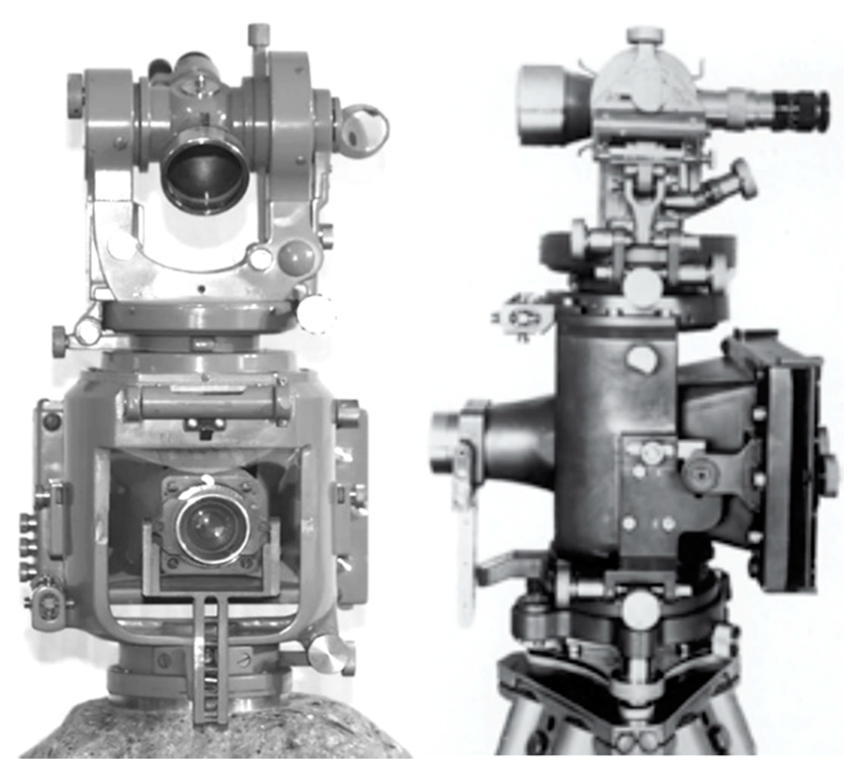
2.2. Development from 1941–1980
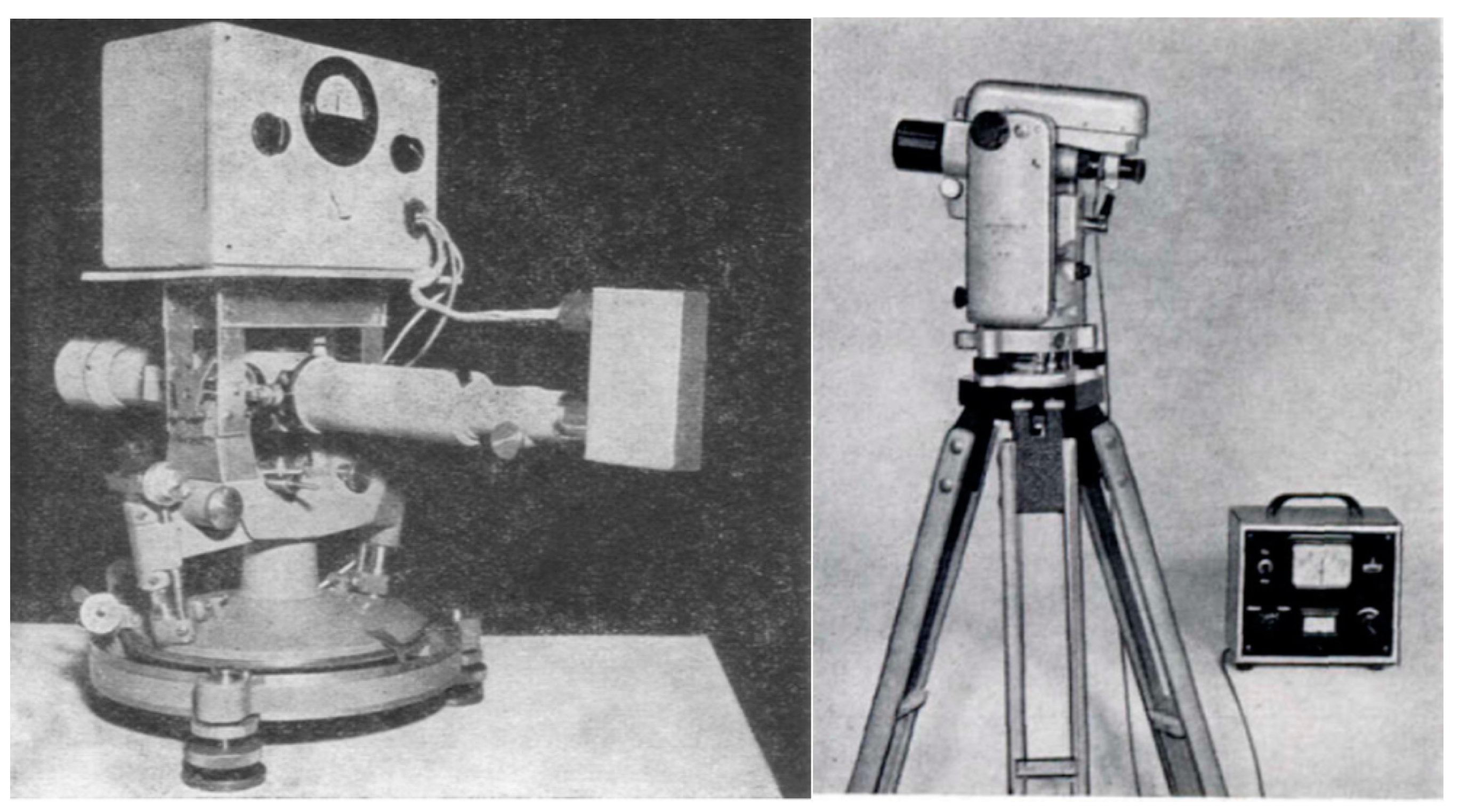
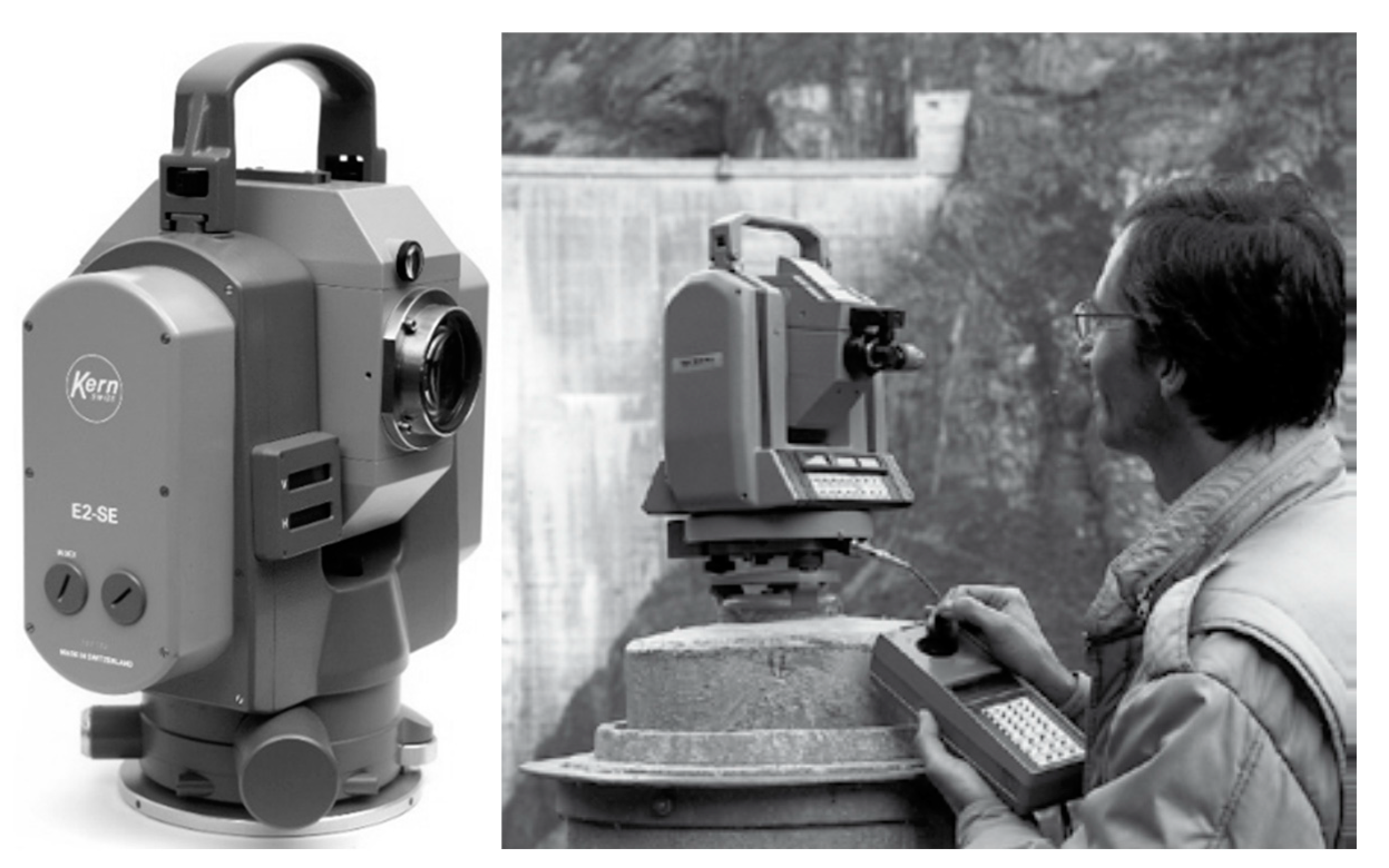
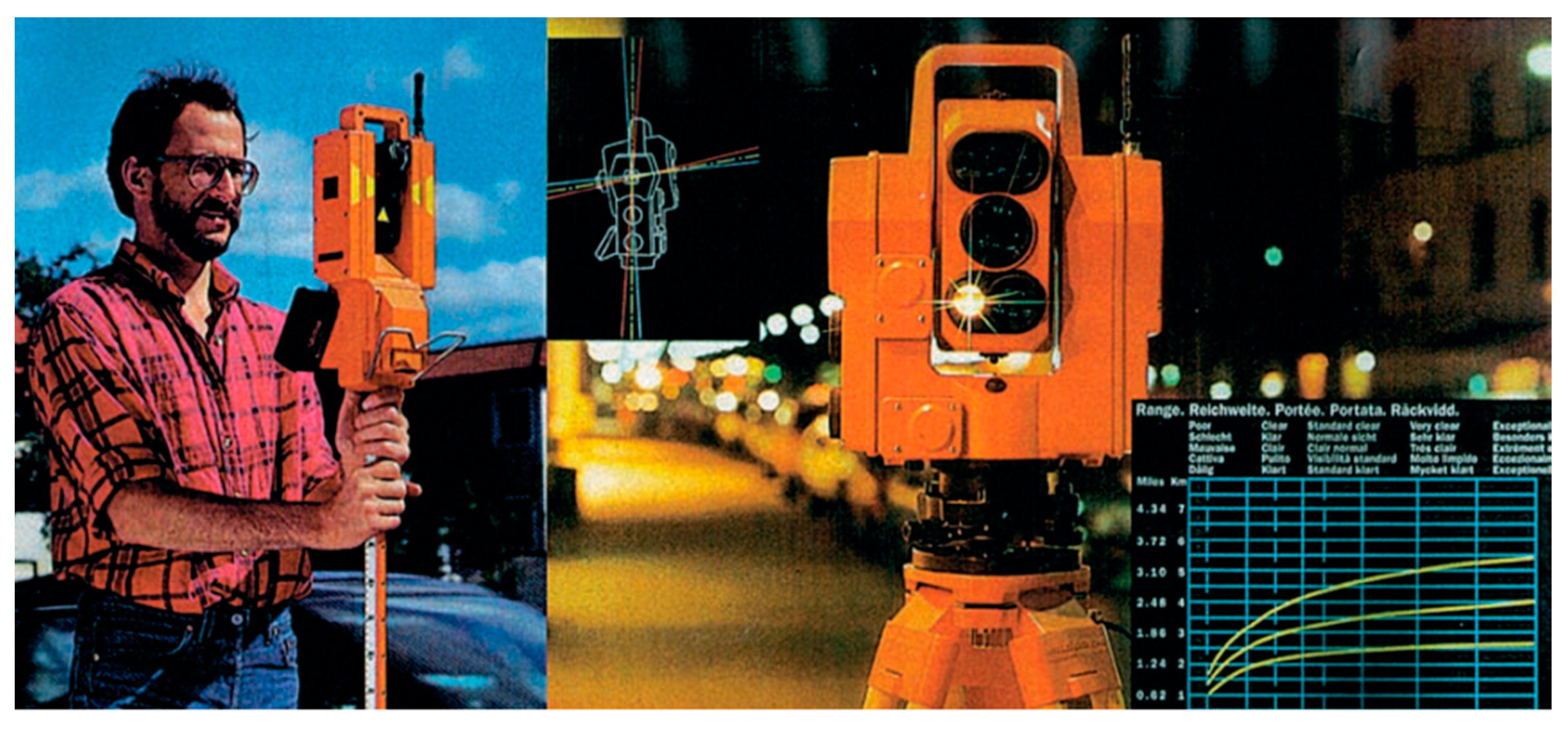
2.3. Development from 1981–1990
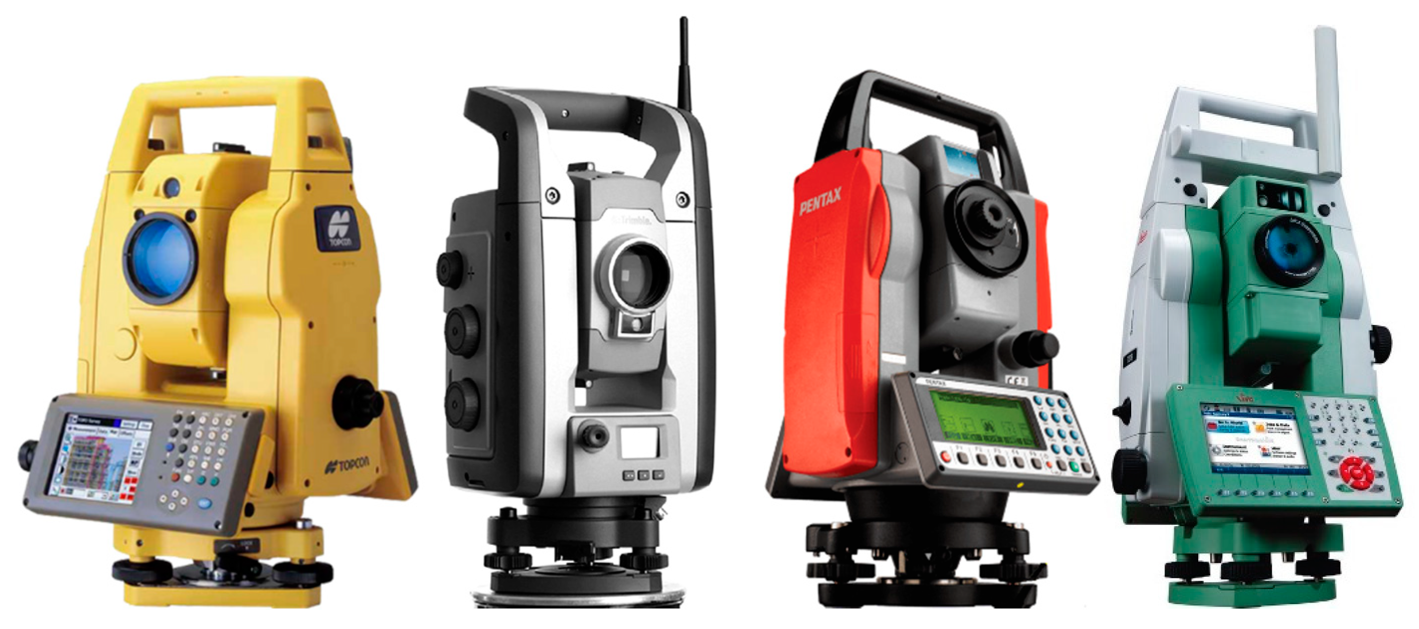
2.4. Development from 1991–2000
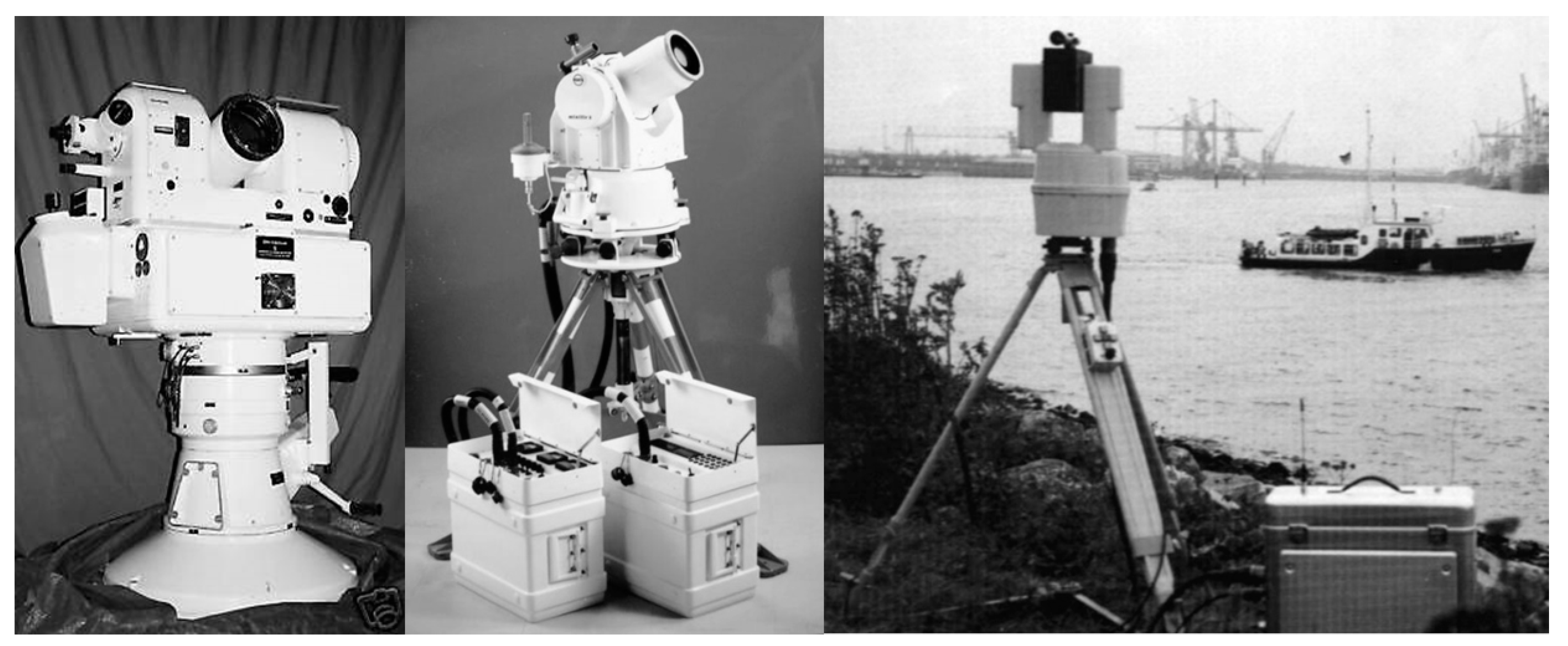
2.5. Development from 2001 until Today
3. Measurement and Processing Approaches
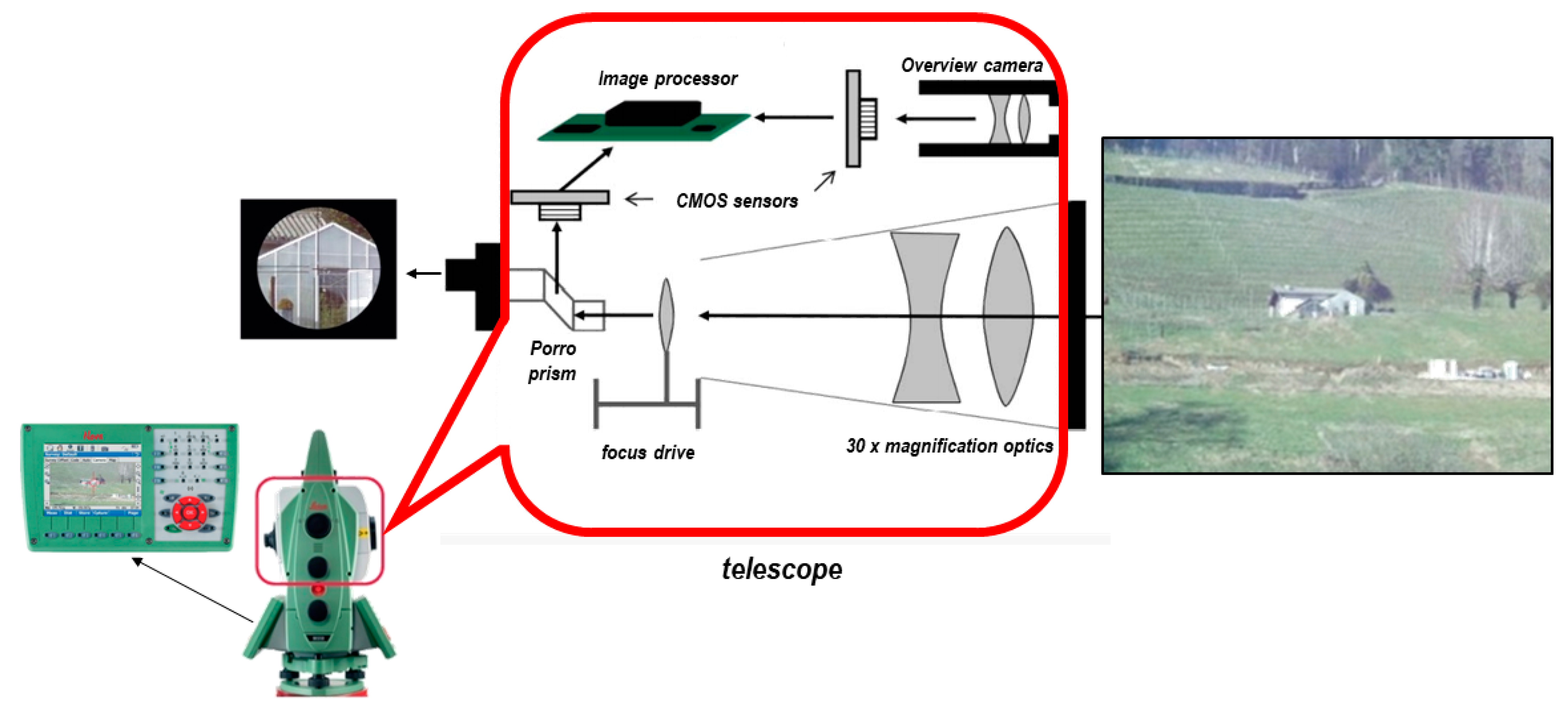
3.1. IATS Basic Principles
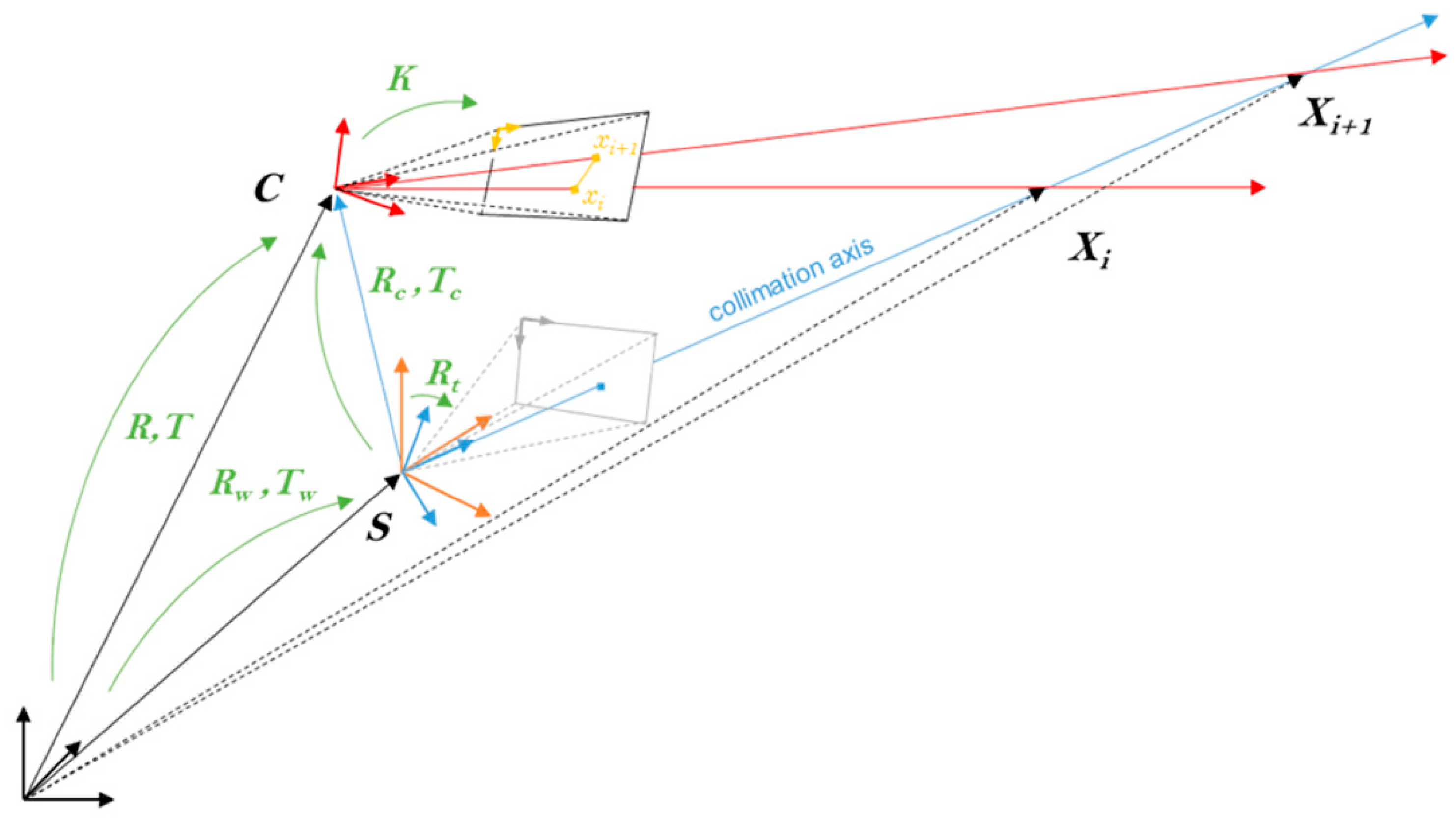
3.2. IATS System and Camera Calibration
- Transformation from the world or object coordinate system into the theodolite coordinate system (Rw, Tw);
- Transformation (pure rotation) into the telescope coordinate system (Rt);
- Transformation into the camera coordinate system (Rc, Tc).
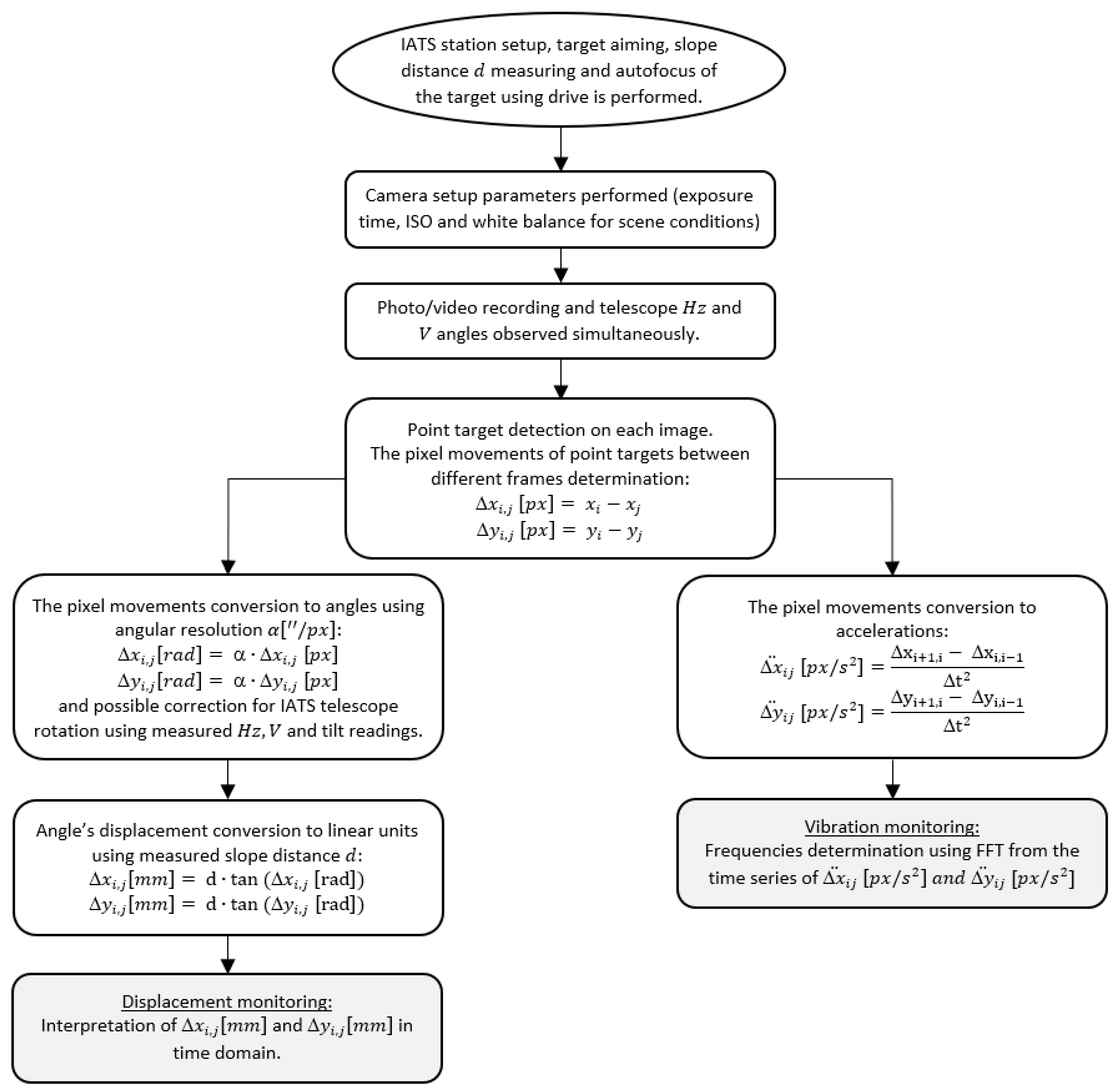
3.3. IATS Measurment Procedures and Data Processing
4. Application of the State-of-the-Art Video Theodolites—IATS in Monitoring
- Structural monitoring refers to the measurement and evaluation of civil engineering structures such as bridges, tunnels, dams, railways, towers, or skyscrapers, i.e., generally manmade objects.
- Geo-monitoring, in contrast, is used as a term for the determination of changes, movements, or deformation of natural structures, such as landslides and slopes.
4.1. Applications in Structural and Geo-Monitoring
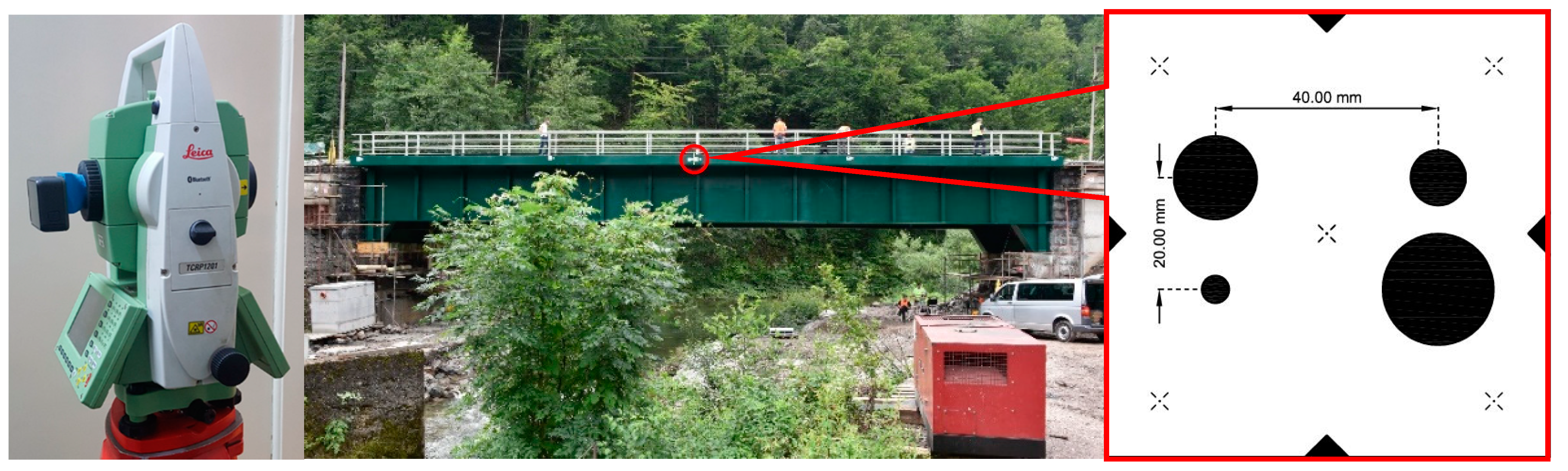
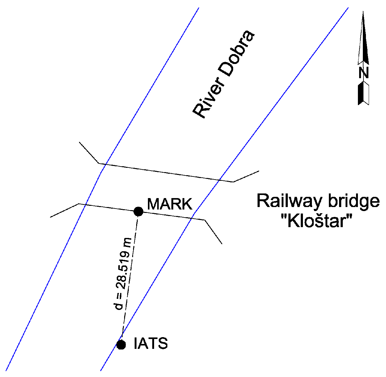
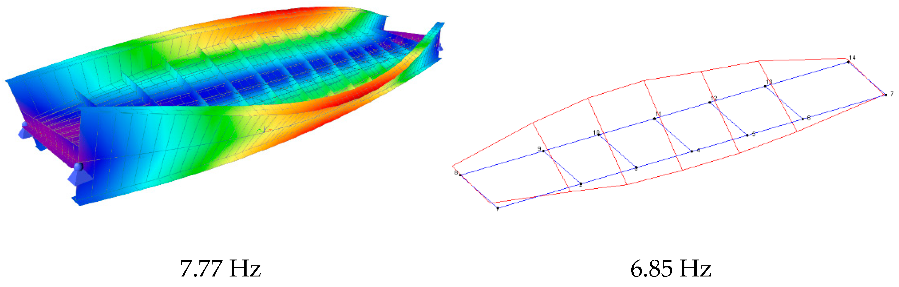
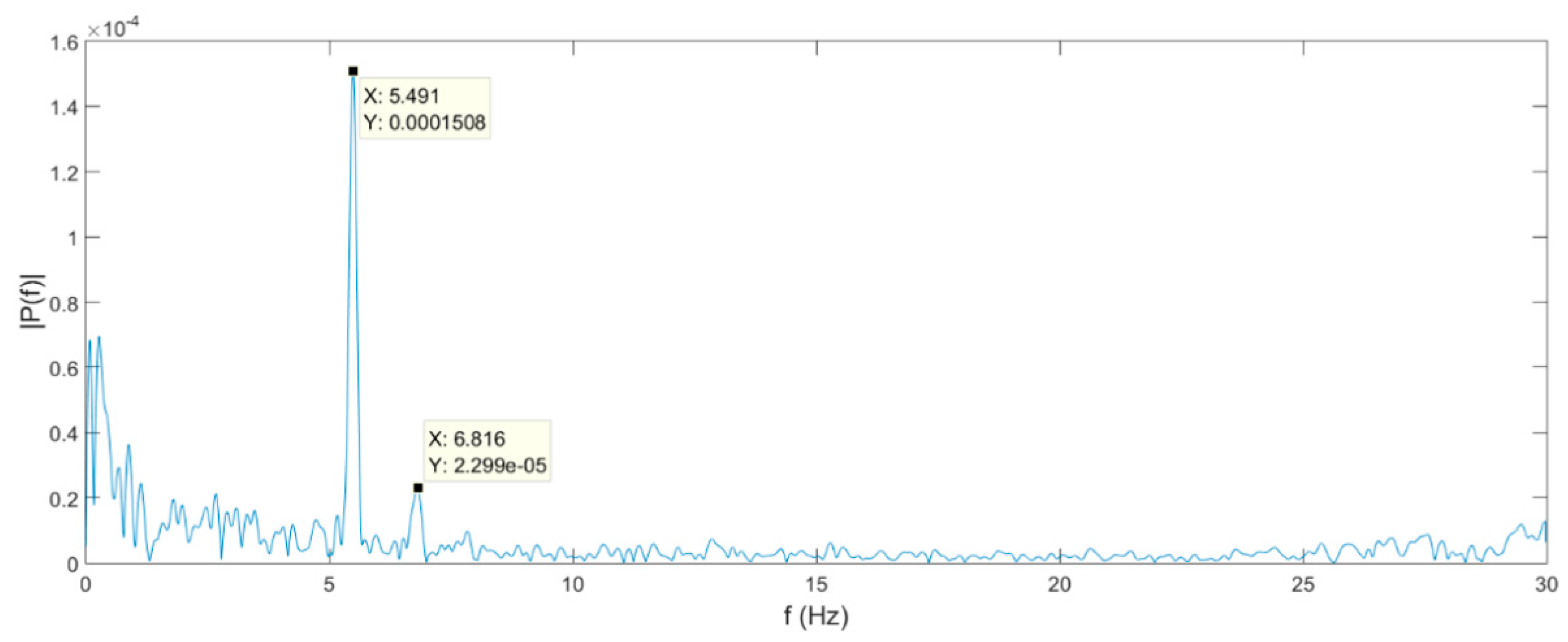
4.2. Case Study
5. Discussion
Author Contributions
Funding
Institutional Review Board Statement
Informed Consent Statement
Data Availability Statement
Conflicts of Interest
References
- Bannister, A.; Raymond, S.; Baker, R. Surveying, 6th ed.; Longman Scientific & Technical: London, UK, 1992; ISBN 0-470-21845-2. [Google Scholar]
- Benčić, D.; Solarić, N. Mjerni Instrumenti i Sustavi u Geodeziji i Geoinfromatici; Školska Knjiga: Zagreb, Croatia, 2008. [Google Scholar]
- Ogundare, J.O. Precise Surveying; John Wiley & Sons: Hoboken, NJ, USA, 2016; ISBN 978-1-119-10251-9. [Google Scholar]
- Lemmens, M. Total Stations: The Surveyor’s Workhorse. GIM Int. 2016, 30, 20–25. [Google Scholar]
- Wunderlich, T.; Wasmeier, P.; Wagner, A. Auf dem Weg zum geodätischen Universalinstrument—Wie nahe am Ziel sind IATS und MS50? In Proceedings of the Terrestrisches Laserscanning 2014 (TLS 2014), Fulda, Germany, 11–12 December 2014; pp. 177–192. [Google Scholar]
- Lienhart, W.; Ehrhart, M.; Grick, M. High frequent total station measurements for the monitoring of bridge vibrations. J. Appl. Geod. 2017, 11, 1–8. [Google Scholar] [CrossRef]
- Wagner, A.; Wasmeier, P.; Reith, C.; Wunderlich, T. Bridge Monitoring by Means of Video-Tacheometer—A Case Study. AVN Allg. Vermess. Nachr. 2013, 120, 283–292. [Google Scholar]
- Wagner, A. New Geodetic Monitoring Approaches Using Image Assisted Total Stations. Ph.D. Thesis, Technische Universität München, München, Germany, 2017. [Google Scholar]
- Koppe, C. Die Photogrammetrie Oder Bildmesskunst; Verlag der Deutschen Photographen-Zeitung: Weimar, Germany, 1889. [Google Scholar]
- Ott, M. Photogrammetrischer Theodolit für Hochgebirgsaufnahmen: Nach Angabe von Professor Dr. S. Finsterwalder in München neu konstruiert. Z. Instrum. 1895, 15, 370–373. [Google Scholar]
- Walser, B.H. Development and Calibration of an Image Assisted Total Station. Ph.D. Thesis, ETH Zürich, Zürich, Switzerland, 2004. [Google Scholar]
- Alexander, R.; Lehmann, M.; Kahmen, H.; Paar, G.; Miljanovic, M.; Ali, H.; Egly, U.; Eiter, T. A 3D optical deformation measurement system supported by knowledge-based and learning techniques. J. Appl. Geod. 2009, 3, 1–13. [Google Scholar] [CrossRef]
- Knoblach, S. Entwicklung, Kalibrierung und Erprobung eines Kameraunterstützten Hängetachymeters. Ph.D. Thesis, Technische Universität Dresden, Dresden, Germany, 2009. [Google Scholar]
- Wasmeier, P. Grundlagen der Deformationsbestimmung mit Messdaten Bildgebender Tachymeter. Ph.D. Thesis, Technische Universität München, München, Germany, 2009. [Google Scholar]
- Reiterer, A.; Wagner, A. System Considerations of an Image Assisted Total Station—Evaluation and Assessment. AVN Allg. Vermess.-Nachr. 2012, 119, 83–94. [Google Scholar]
- Huep, W. Scannen mit der trimble VX spatial station. Z. Vermess. 2010, 135, 330–336. [Google Scholar]
- Gruner, H. Photogrammetry: 1776–1976. Photogramm. Eng. Remote Sens. 1977, 43, 569–574. [Google Scholar]
- Frankich, K. Close Range Photogrammetric Systems and Their Applications in Ophthalmology. Ph.D. Thesis, The University of British Columbia, Vancouver, BC, Canada, 1973. [Google Scholar]
- Finsterwalder, R.; Hofmann, W. Photogrammetrie, 3rd ed.; Walter de Gruyter & Co.: Berlin, Germany, 1968. [Google Scholar]
- Leica Geosystems 200 Years of Surveying History. Available online: https://leica-geosystems.com/about-us/summary/history (accessed on 25 March 2021).
- Gigas, E.; Ebeling, K. Elektrisches Auge. In DGK; Institut für Angewandte Geodäsie: Frankfurt, Germany, 1957; Volume B. [Google Scholar]
- Wagner, A.; Wasmeier, P.; Wunderlich, T.; Ingensand, H. Vom selbstzielenden Theodolit zur Image Assisted Total Station From the Self-aiming Theodolite to Image Assisted Total Stations. AVN Allg. Vermess. Nachr. 2014, 121, 171–180. [Google Scholar]
- C & D Professional Services Contraves EOTS Cinetheodolite. Available online: http://www.cdproservices.com/product_0903g.html (accessed on 25 March 2021).
- Hilster, N. de 1980 SAT AGA-Minilir. Available online: http://www.dehilster.info/geodetic_instruments/1980_sat-sagem_AGA-Minilir.php#note1 (accessed on 25 March 2021).
- Wentzell, H.F. Polarfix: A new concept in high accuracy position fixing. World Dredg. Mar. Constr. 1983, 19, 9. [Google Scholar]
- Ingensand, H. 2000 Jahre Theodolit: Von Heron bis Heinrich Wild. Vermess. Photogramm. Kult. 1992, 90, 128–140. [Google Scholar]
- Kahmen, H.; Suhre, H. Ein lernfähiges tachymetrisches Vermessungssystem zur Überwachung kinematischer Vorgänge ohne Beobachter. Z. Geodäsie Geoinf. Landmanag. 1983, 108, 345–351. [Google Scholar]
- Kahmen, H.; Steudel, J. Das automatisch zielende Messsystem GEOROBOT II. In Proceedings of the Xth Internationalen Kurs für Ingenieurvermessung, München, Germany, 12–17 September 1988. [Google Scholar]
- Gottwald, R. Kern E2-SE—Ein neues Instrument nicht nur für die Industrievermessung? AVN Allg. Vermess. Nachr. 1987, 147–153. [Google Scholar]
- Katowski, O. Deformationsmessung an Bauwerken mit dem automatischen TheodolitmessSystem ATMS. In Optical 3-D Measurement Techniques; Wichmann: Karlsruhe, Germany, 1989; pp. 393–403. [Google Scholar]
- Kennie, T.J.M.; Petrie, G. (Eds.) Engineering Surveying Technology; Taylor & Francis Group: London, UK; New York, NY, USA, 1990; Volume 27, ISBN 0751401935. [Google Scholar]
- Lienhart, W. Integrated Digital Imaging and Its Impact on Survey Workflows; Visualisation Technical; PositionIT: Muldersdrift, South Africa, 2011; pp. 51–55. [Google Scholar]
- Kahmen, H.; Roić, M. A new generation of measurement robots for object reconstruction without targeting. In Proceedings of the Optical 3d Measurements III, Vienna, Austria, 2–4 October 1995; pp. 251–262. [Google Scholar]
- Fabiankowitsch, J. Automatische Richtungsmessung mit Digitalen Differenzbildern; TU Vienna: Vienna, Austria, 1990. [Google Scholar]
- Mischke, A. Entwicklung Eines Videotheodolit-Meßsystems zur Automatischen Richtungsmessung von Nicht Signalisierten Objektpunkten; TU Vienna: Vienna, Austria, 2000; Volume 54. [Google Scholar]
- Reiterer, A.; Vicovac, T.; Egly, U.; Mai, E.; Moafipoor, S.; Grejner-Brzezinska, D.A.; Toth, C.K. Application of artificial intelligence in Geodesy—A review of theoretical foundations and practical examples. J. Appl. Geod. 2010, 4, 201–217. [Google Scholar] [CrossRef][Green Version]
- Roić, M. Erfassung von Nicht Signalisierten 3D-Strukturen mit Videotheodoliten. Ph.D. Thesis, Technische Universität Wien, Vienna, Austria, 1994. [Google Scholar]
- Matthias, H. Der Roboter-Theodolit Topomat: Technik, Anwendungen und Auswirkungen auf den Beruf. Vermess. Photogramm. Kult. 1991, 8, 427–431. [Google Scholar] [CrossRef]
- Topcon Topcon Museum|Total Station. Available online: https://www.topcon.co.jp/en/positioning/museum/ts/ (accessed on 15 March 2021).
- Ingensand, H.; Boeckem, B. Automatic Location and Pointing Techniques in Local Positioning Systems. In Proceedings of the 4th Conference on Optical 3-D Measurement Techniques, Zürich, Switzerland, 29 September–2 October 1997; pp. 329–338. [Google Scholar]
- Topcon GPT-7000i Specifications. Available online: http://www.topcon.si/zares 4/dokumenti/gpt-7000i.pdf (accessed on 25 March 2021).
- Topcon GPT-9000Ai Specifications. Available online: https://totalstations.co/wp-content/uploads/2017/07/Topcon-GPT-9001A-Edited-1.pdf (accessed on 11 March 2021).
- Trimble Trimble VX Spatial Station. Available online: http://trl.trimble.com/docushare/dsweb/Get/Document-348124/022543-261F_TrimbleVX_DS_0110_lr.pdf (accessed on 25 March 2021).
- Pentax R-400VDN Series. Available online: https://pdf.archiexpo.com/pdf/pentax-precision/r-400vdn-series/151417-284341.html (accessed on 25 March 2021).
- Leica Geosystems, A. Leica Viva TS11 Datasheet. Available online: https://leica-geosystems.com/-/media/files/leicageosystems/products/brochures/tender-flexline-plus/leica-viva-ts11-ds-lr.ashx?la=en&hash=8467ACC4E2E31C6DFF7C1497091D3692 (accessed on 25 March 2021).
- Leica Geosystems, A. Leica Viva TS15 Datasheet. Available online: http://kumonos.info/downloads/datasheet_ts15.pdf (accessed on 25 March 2021).
- Wagner, A.; Wiedemann, W.; Wasmeier, P.; Wunderlich, T. Improved concepts of using natural targets for geo-monitoring. In Proceedings of the 3rd Joint International Symposium on Deformation Monitoring (JISDM), Vienna, Austria, 30 March–1 April 2016. [Google Scholar]
- Wagner, A.; Wiedemann, W.; Wunderlich, T. Fusion of Laser Scan and Image Data for Deformation Monitoring—Concept and Perspective. In Proceedings of the INGEO—7th International Conference on Engineering Surveying, Lisbon, Portugal, 18–20 October 2017; pp. 157–164. [Google Scholar]
- Whitt, M. Trimble S Series Total Station Comparison—Positioning Solutions. Available online: https://positioningsolutions.com/blogs/product-info/total-station-comparison (accessed on 25 March 2021).
- Topocn DS-200i Series Imaging Robotic Total Station. Available online: https://www.topconpositioning.com/sites/default/files/product_files/ds-200i_series_broch_7010_2160_revc_sm.pdf (accessed on 25 March 2021).
- Maar, H.; Zogg, H.-M. Leica Nova MS60 White Paper. Available online: http://leica-geosystems.com/products/total-stations/multistation/leica-nova-ms60 (accessed on 25 March 2021).
- Trimble Trimble SX10|Scanning Total Station. Available online: https://geospatial.trimble.com/products-and-solutions/trimble-sx10 (accessed on 25 March 2021).
- Trimble Trimble SX12|Scanning Total Station. Available online: https://geospatial.trimble.com/SX12 (accessed on 25 March 2021).
- Topcon Topcon GTL-1000 Laser Scanner Total Station. Available online: https://www.topcon.co.jp/en/positioning/products/pdf/GTL-1000_E.pdf (accessed on 25 March 2021).
- Wagner, A. A new approach for geo-monitoring using modern total stations and RGB + D images. Meas. J. Int. Meas. Confed. 2016, 82, 64–74. [Google Scholar] [CrossRef]
- Huep, W. Konzeption und Einsatzmöglichkeiten eines automatisierten Theodolitsystems. In Proceedings of the Xth Internationaler Kurs für Ingenieurvermessung, München, Germany, 12–17 September 1988. [Google Scholar]
- Grimm, D.E.; Zogg, H.-M. Leica Nova MS50 White Paper. Available online: https://www.google.hr/url?sa=t&rct=j&q=&esrc=s&source=web&cd=&cad=rja&uact=8&ved=2ahUKEwiVlMOpxKDvAhVmyoUKHeveD-IQFjAAegQIAhAD&url=https%3A%2F%2Fw3.leica-geosystems.com%2Fdownloads123%2Fzz%2Ftps%2Fnova_ms50%2Fwhite-tech-paper%2Fleica_nova_ms50_tpa_en.pdf& (accessed on 25 March 2021).
- Grimm, D.; Kleemaier, G.; Zogg, H.-M. ATRplus White Paper. Available online: https://leica-geosystems.com/-/media/files/leicageosystems/products/white-papers/atrplus_wp.ashx?la=en&hash=91E09F6A1CF79DE10D9B742391F7B35F (accessed on 25 March 2021).
- Ehrhart, M.; Lienhart, W. Development and evaluation of a long range image-based monitoring system for civil engineering structures. In Proceedings of the SPIE 9437, Structural Health Monitoring and Inspection of Advanced Materials, Aerospace, and Civil Infrastructure 2015, Aerospace, San Diego, CA, USA, 9–12 March 2015. [Google Scholar]
- Hartley, R.; Zisserman, A. Multiple View Geometry in Computer Vision; Cambridge University Press: Cambridge, UK, 2004; ISBN 9780521540513. [Google Scholar]
- Vogel, M. Vom Pixel zur Richtung Die Räumlichen Beziehungen Zwischen Abbildungsstrahlen und Tachymeter-Richtungen. Ph.D. Thesis, Technische Universität Darmstadt, Darmstadt, Germany, 2006. [Google Scholar]
- Wagner, A.; Wiedemann, W.; Wunderlich, T. Using IATS to Read and Analyze Digital Leveling Staffs. In Proceedings of the International Symposium on Engineering Geodesy—SIG 2016, Varaždin, Croatia, 20–22 May 2016; pp. 515–526. [Google Scholar]
- Wagner, A.; Wiedemann, W.; Wasmeier, P.; Wunderlich, T. Monitoring Concepts using Image Assisted Total Stations. In Proceedings of the International Symposium on Engineering Geodesy—SIG 2016, Varaždin, Croatia, 20–22 May 2016; pp. 137–148. [Google Scholar]
- Ehrhart, M.; Lienhart, W. Monitoring of Civil Engineering Structures using a State-of-the-art Image Assisted Total Station. J. Appl. Geod. 2015, 9. [Google Scholar] [CrossRef]
- Cosser, E.; Roberts, G.W.; Meng, X.; Dodson, A. Measuring the dynamic deformation of bridges using a total station. In Proceedings of the 11th FIG Symposium on Deformation Measurements, Santorini, Greece, 25–28 May 2003; pp. 605–612. [Google Scholar]
- Lekidis, V.; Tsakiri, M.; Makra, K.; Karakostas, C.; Klimis, N.; Sous, I. Evaluation of dynamic response and local soil effects of the Evripos cable-stayed bridge using multi-sensor monitoring systems. Eng. Geol. 2005, 79, 43–59. [Google Scholar] [CrossRef]
- Psimoulis, P.; Moschas, F.; Stiros, S. Measuring the Displacements of a rigid footbridge using geodetic instruments and an ac-celerometer. In Proceedings of the 1st Joint International Symposium on Deformation Monitoring, Hong Kong, China, 2–4 November 2011. [Google Scholar]
- Gikas, V.; Daskalakis, S. Comparative testing and analysis of RTS vs. In GPS for structural monitoring using calibra-tion measurements upon sinusoidal excitation. In Proceedings of the 13th FIG Symposium on Deformation Measurement and Analysis, Lisbon, Portugal, 12–15 May 2008. [Google Scholar]
- Palazzo, D.R.; Friedmann, R.M.P.; Nadal, C.A.; Filho, M.L.S.; Veiga, L.A.K.; Faggion, P.L. Dynamic monitoring of structures using a robotic total station. In Proceedings of the 23th International FIG Congress, Munich, Germany, 8–13 October 2006.
- Gikas, V.; Daskalakis, S. Full scale validation of tracking total stations using a long stroke electrodynamic shaker. In Proceedings of the 23th International FIG Congress, Munich, Germany, 8–13 October 2006. [Google Scholar]
- Stempfhuber, W. Verification of the Trimble Universal Total Station (UTS) Performance for Kinematic Applications. In Proceedings of the Conference on Optical 3-D Measurement Techniques, Vienna, Austria, 1–3 July 2009. [Google Scholar]
- Marendić, A.; Paar, R.; Damjanović, D. Measurement of bridge dynamic displacements and natural frequencies by RTS. Gradev. J. Croat. Assoc. Civ. Eng. 2017, 69, 281–294. [Google Scholar] [CrossRef]
- Roberts, G.W.; Meng, X.; Dodson, A.H. Integrating a Global Positioning System and Accelerometers to Monitor the Deflection of Bridges. J. Surv. Eng. 2004, 130, 65–72. [Google Scholar] [CrossRef]
- Yu, J.; Meng, X.; Shao, X.; Yan, B.; Yang, L. Identification of dynamic displacements and modal frequencies of a medium-span suspension bridge using multimode GNSS processing. Eng. Struct. 2014, 81, 432–443. [Google Scholar] [CrossRef]
- Meng, X.; Nguyen, D.; Xie, Y.; Owen, J.; Psimoulis, P.; Ince, S.; Chen, Q.; Ye, J.; Bhatia, P. Design and Implementation of a New System for Large Bridge Monitoring—GeoSHM. Sensors 2018, 18, 775. [Google Scholar] [CrossRef]
- Kaloop, M.; Elbeltagi, E.; Hu, J.; Elrefai, A. Recent Advances of Structures Monitoring and Evaluation Using GPS-Time Series Monitoring Systems: A Review. ISPRS Int. J. Geo-Inf. 2017, 6, 382. [Google Scholar] [CrossRef]
- Yu, J.; Meng, X.; Yan, B.; Xu, B.; Fan, Q.; Xie, Y. Global Navigation Satellite System-based positioning technology for structural health monitoring: A review. Struct. Control Heal. Monit. 2020, 27. [Google Scholar] [CrossRef]
- Paar, R. Geospatial Data Bases of Objects in the Highway Management System of the Republic of Croatia. Ph.D. Thesis, University of Zagreb, Zagreb, Croatia, 2010. [Google Scholar]
- Ehrhart, M.; Lienhart, W.; Kalenjuk, S. Monitoring of Bridge vibrations with image-assisted total stations. In Proceedings of the 4th Conference on Smart Monitoring, Assessment and Rehabilitation of civil Structures (SMAR), Zurich, Switzerland, 13–15 September 2017. [Google Scholar]
- Ehrhart, M.; Lienhart, W. Image-based dynamic deformation monitoring of civil engineering structures from long ranges. In Proceedings of the SPIE 9405, Image Processing: Machine Vision Applications VIII, San Francisco, CA, USA, 10–11 February 2015. [Google Scholar]
- Paar, G. Deformation Monitoring by High Resolution Terrestrial Long Range Sensing. 2014. Available online: https://cordis.europa.eu/project/id/285839 (accessed on 25 March 2021).
- Wagner, A.; Huber, B.; Wiedemann, W.; Paar, G. Long-Range Geo-Monitoring Using Image Assisted Total Stations. J. Appl. Geod. 2014, 8. [Google Scholar] [CrossRef]
- Paar, R.; Marendić, A.; Wagner, A.; Wiedemann, W.; Wunderlich, T.; Roić, M.; Damjanović, D. Using IATS and digital levelling staffs for the determination of dynamic displacements and natural oscillation frequencies of civil engineering structures. In Proceedings of the INGEO 2017—7th International Conference on Engineering Surveying, Lisbon, Portugal, 18–20 October 2017. [Google Scholar]


| Specifications | Leica TS60 | Trimble S9 | Topcon DS-200i |
|---|---|---|---|
| Camera/sensor | 2×/CMOS | 1×/CMOS | 1×/CMOS |
| Resolution | 5 MPx | 3 MPx | 5 MPx |
| Fps | 20 Hz | 5 Hz | Live video 1 |
| FOV overview/telescope | 15.5° × 11.7°/1.3° × 1.0° | 16.5° × 12.3°/✗ | Ultra-wide 1/✗ |
| Zoom overview/telescope | 8×/30× | 8×/✗ | 1 |
| Accuracy distance (prism) | 0.6 mm + 1 ppm | 0.8 mm + 1 ppm | 1.5 mm + 2 ppm |
| Accuracy distance (non-prism) | 2 mm + 2 ppm | 2 mm + 2 ppm | 2 mm + 2 ppm |
| Accuracy Hz and V | 0.5″ | 0.5″ | 1″ |
| Scanning function | ✗ | • | ✗ |
| Year released | 2015 | 2015 | 2014 |
| Specifications | Leica MS60 | Trimble SX 12 | Topcon GTL-1000 |
|---|---|---|---|
 |  |  | |
| Camera/sensor | 2×/CMOS | 3×/CMOS | 1×/CMOS |
| Resolution | 5 MPx | 8.1 MPx | 5 MPx |
| Fps | 20 Hz | 15 Hz | Live video |
| FOV overview/telescope | 15.5° × 11.7°/1.3° × 1.0° | 2 Total 360° × 300° | 270° × 360°/✗ |
| Zoom overview/telescope | 8×/30× | 107× 3 | 1 |
| Accuracy distance (prism) | 1 mm + 1.5 ppm | 1 mm + 1.5 ppm | 1 mm + 2 ppm |
| Accuracy distance (non-prism) | 2 mm + 2 ppm | 2 mm + 1.5 ppm | 2 mm + 2 ppm |
| Accuracy Hz and V | 1″ | 1″ | 1″ |
| Scan rate | 30,000 Hz | 26,600 Hz | 100,000 Hz |
| Year released | 2020 | 2021 | 2019 |
| TS | RTS | IATS | IASTS | |
|---|---|---|---|---|
| EDM | ✓ | ✓ | ✓ | ✓ |
| Reflectorless EDM | • | • | ✓ | ✓ |
| Data registration | ✓ | ✓ | ✓ | ✓ |
| Motorization | ✗ | ✓ | ✓ | ✓ |
| Image sensor | ✗ | ✓/• | ✓ | ✓ |
| Automated aiming | ✗ | ✓/• | ✓ | ✓ |
| Tracking | ✗ | ✓/• | ✓ | ✓ |
| Imaging | ✗ | ✗ | ✓ | ✓ |
| Scanning | ✗ | ✗ | ✗/• | ✓ |
Publisher’s Note: MDPI stays neutral with regard to jurisdictional claims in published maps and institutional affiliations. |
© 2021 by the authors. Licensee MDPI, Basel, Switzerland. This article is an open access article distributed under the terms and conditions of the Creative Commons Attribution (CC BY) license (https://creativecommons.org/licenses/by/4.0/).
Share and Cite
Paar, R.; Roić, M.; Marendić, A.; Miletić, S. Technological Development and Application of Photo and Video Theodolites. Appl. Sci. 2021, 11, 3893. https://doi.org/10.3390/app11093893
Paar R, Roić M, Marendić A, Miletić S. Technological Development and Application of Photo and Video Theodolites. Applied Sciences. 2021; 11(9):3893. https://doi.org/10.3390/app11093893
Chicago/Turabian StylePaar, Rinaldo, Miodrag Roić, Ante Marendić, and Stjepan Miletić. 2021. "Technological Development and Application of Photo and Video Theodolites" Applied Sciences 11, no. 9: 3893. https://doi.org/10.3390/app11093893
APA StylePaar, R., Roić, M., Marendić, A., & Miletić, S. (2021). Technological Development and Application of Photo and Video Theodolites. Applied Sciences, 11(9), 3893. https://doi.org/10.3390/app11093893