
Evaluation Model of Parking Equipment Planning and Design Based on Object-Oriented Technology


Abstract
:1. Introduction
1.1. Research on Increasing Parking Capacity
1.2. Research on the Rationality of Parking Space Planning
1.3. Research on Object-Oriented Technology
1.4. Research Process and Goals
1.4.1. Research Process
1.4.2. Research Goals
- (1)
- In order to quickly and accurately obtain the effective information of the target parking area, comprehensively use multi-scale segmentation processing and high-resolution image analysis technology to classify environmental features;
- (2)
- Based on the research on the classification of environmental features, obtain the plane map required by the parking equipment planning and design evaluation model;
- (3)
- Carry out the planning and design of the parking space from the rationality and suitability design of the parking space, and establish the parking equipment planning and design evaluation model to meet the product experience and actual needs of the target users;
- (4)
- Carry out feasibility study based on specific cases to provide reference for improving the reasonable space planning and design of parking equipment.
2. Model Map Extraction
2.1. Multi-Scale Segmentation of Image
2.1.1. Spectral Heterogeneity
2.1.2. Shape Heterogeneity
2.1.3. Total Heterogeneity
2.2. High Resolution Image Extraction
2.2.1. Spectral Characteristic
2.2.2. Shape Characteristic
2.2.3. Texture Characteristic
2.3. Geometrical Extraction of Model Plane Map
3. Parking Space Planning Model
3.1. Factors Affecting Parking Space Layout
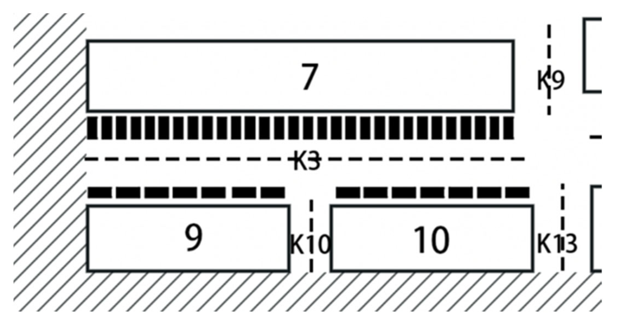
3.2. Maximum Capacity Layout of Parking Spaces
- (1)
- When K ≤ K0 + 2.5, the width K corresponding to a certain direction of the research road is less than the sum of the minimum width K0 specified by the direction road and the national standard width 2.5 m for the size of parking spaces, the two sides of the road cannot be installed parking space.
- (2)
- When K0 + 2.5 < K ≤ K0 + 5, the width K corresponding to a certain direction of the research road is greater than or equal to the sum of the minimum width K0 stipulated by the direction road and the standard width 2.5 m of the national parking space size, but less than the minimum width K0 stipulated by the direction road and the national parking space size when the total standard length is 5.0 m, the road can choose to set parking spaces on both sides of the road but on one side of the road, and the parking spaces are oriented parallel to the road. The number of parking spaces that can be set is R/5, so the number of parking spaces allocated to one side of the research road is R/10.
- (3)
- When K0 + 5 ≤ K < K0 + 7.5, the width K corresponding to a certain direction of the research road is greater than or equal to the sum of the minimum width K0 specified by the direction road and the standard length of 5.0 m specified by the national parking space size, but less than the minimum width K0 specified by the direction road and the national parking space size when the sum of the standard length and width is 7.5 m, the road can be equipped with parking spaces on both sides of the road, and the orientation of the parking spaces on both sides is parallel to the road. The number of parking spaces that can be set is 2R/5, so the number of parking spaces allocated to one side of the research road is R/5.
- (4)
- When K0 + 7.5 ≤ K < K0 + 10, he width K corresponding to the direction of the research road is greater than or equal to the minimum width K0 specified by the direction road and the sum of the standard length and width of the national parking space size is 7.5 m, but it is less than the minimum width K0 specified by the direction road and the national when the size of the parking space is twice the standard length and 10.0 m, the road can have parking spaces on both sides of the road. One side of the parking space is oriented parallel to the road, and the number of parking spaces on this side is R/5. The other side of the parking space is oriented perpendicular to the road, and the number of parking spaces on this side is 2R/5.
- (5)
- When K0 + 10 ≤ K < K0 + 12.5, the width K of a certain direction of the research road is greater than or equal to the minimum width K0 specified by the direction of the road and the standard length of the national parking space size is twice and 10.0 m, the road can be equipped with parking spaces on both sides of the road. The side parking spaces are all perpendicular to the road. The number of parking spaces that can be set is 4R/5, so the number of parking spaces allocated to one side of the research road is 2R/5.
3.3. Planning of Accessible Parking Spaces
3.4. Layout of Multi-Storey Parking Equipment
4. Practical Application
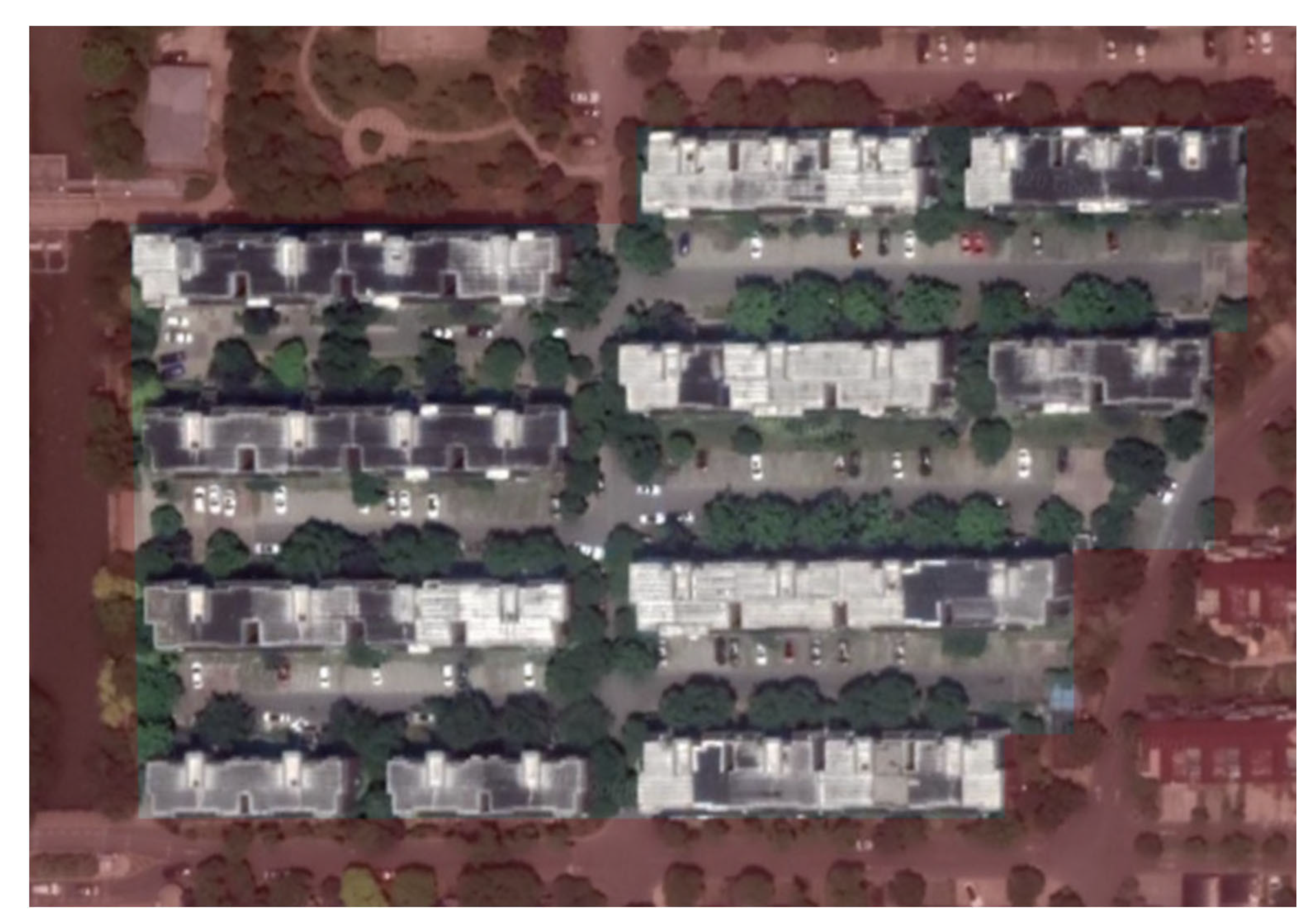
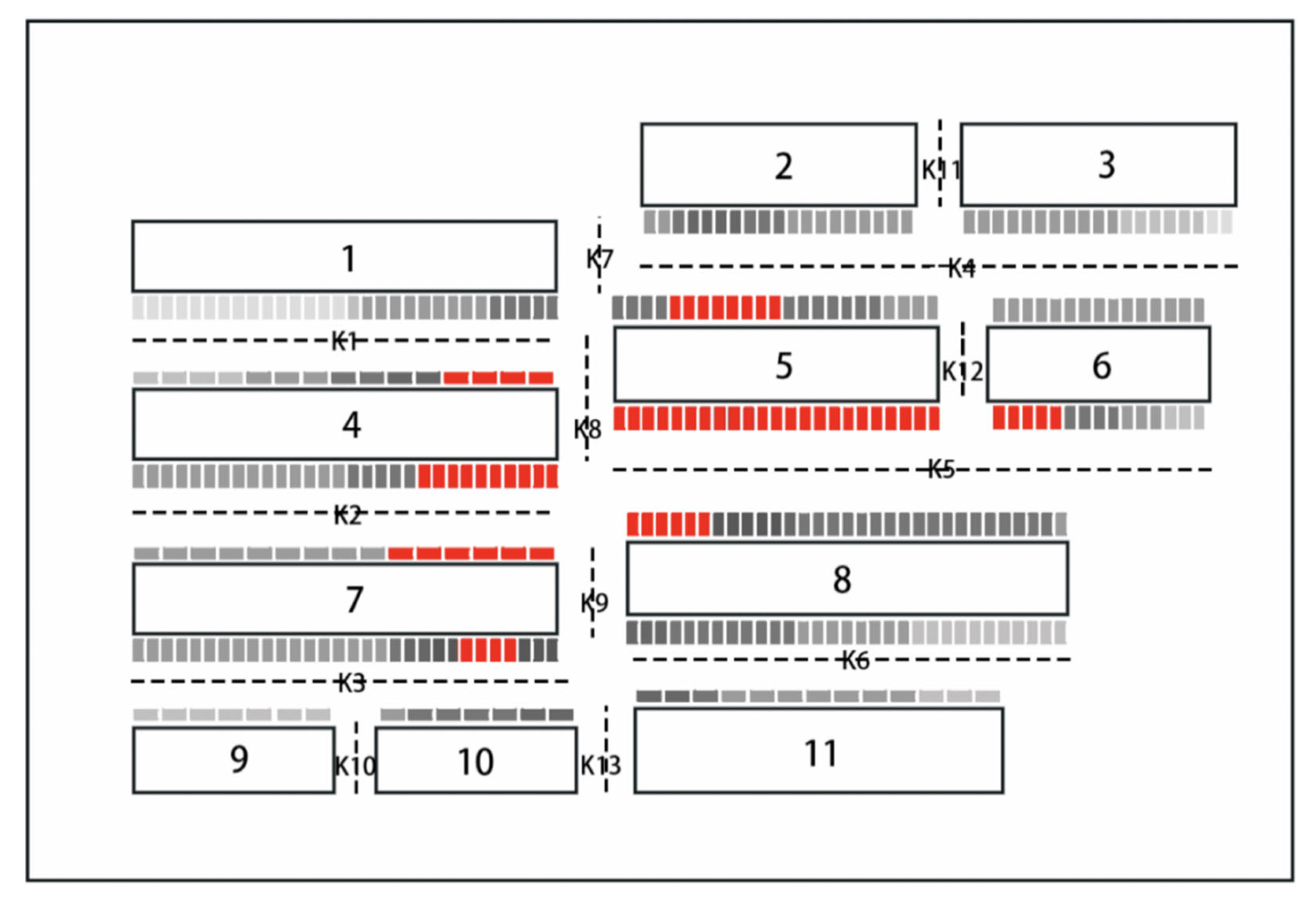
4.1. Characteristics of the Study Area
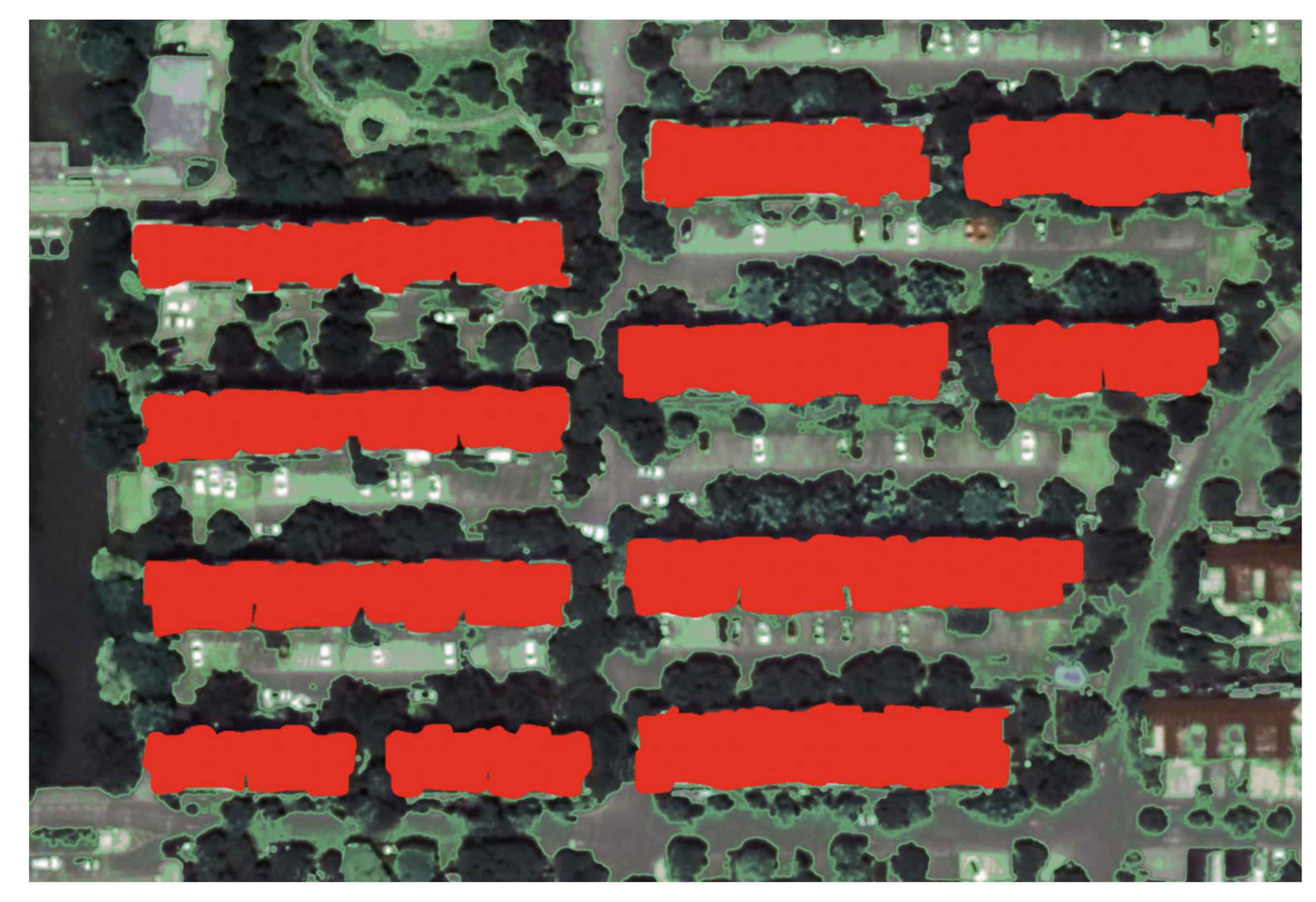
4.2. Plane Map Extraction of the Study Area
4.2.1. Multi-Scale Image Segmentation
4.2.2. Image Extraction
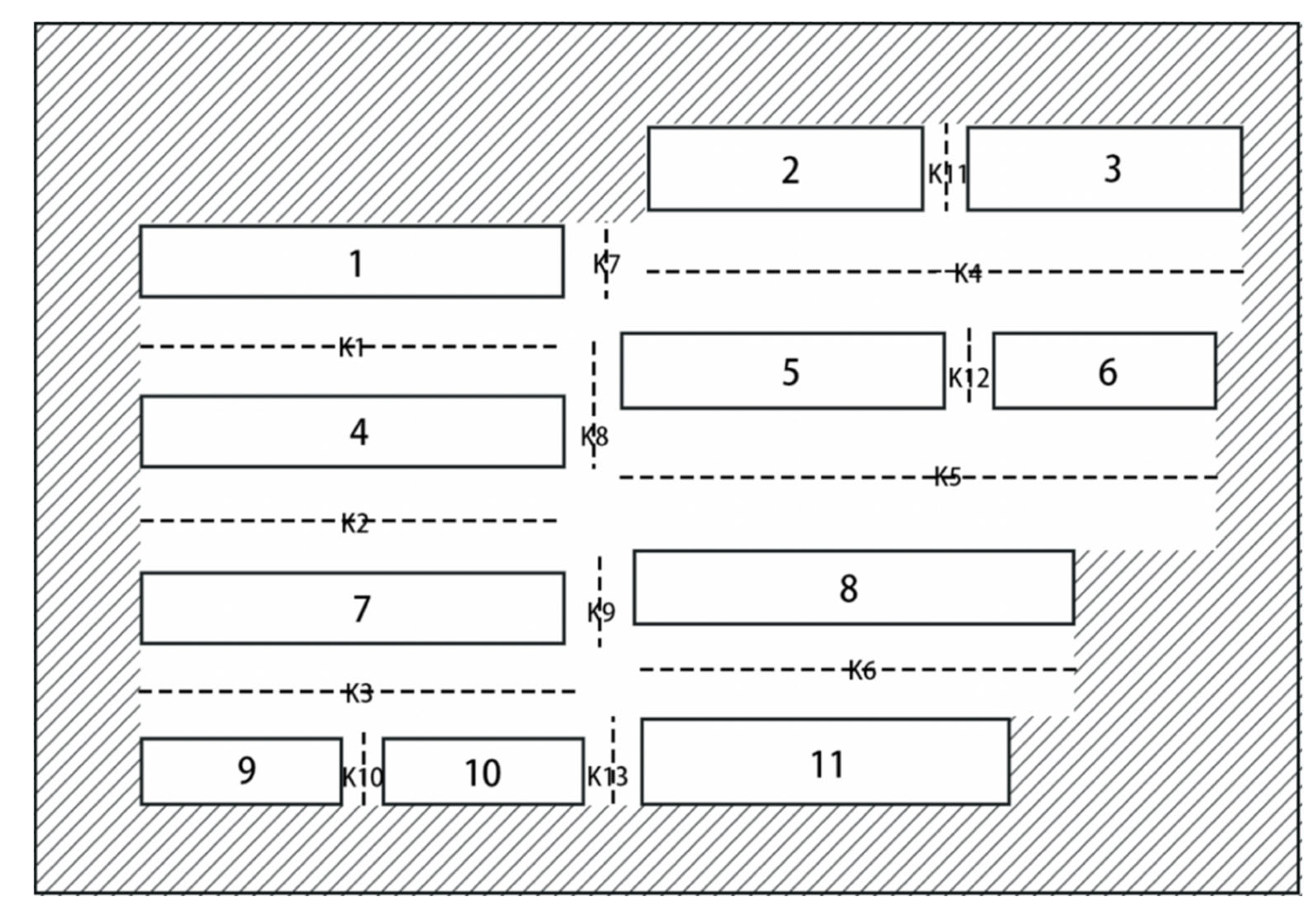
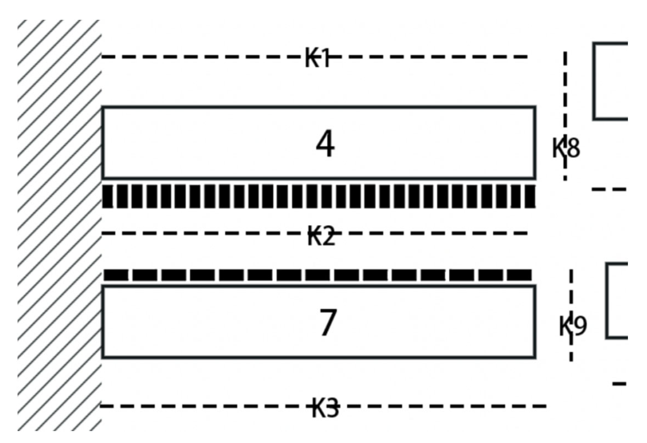
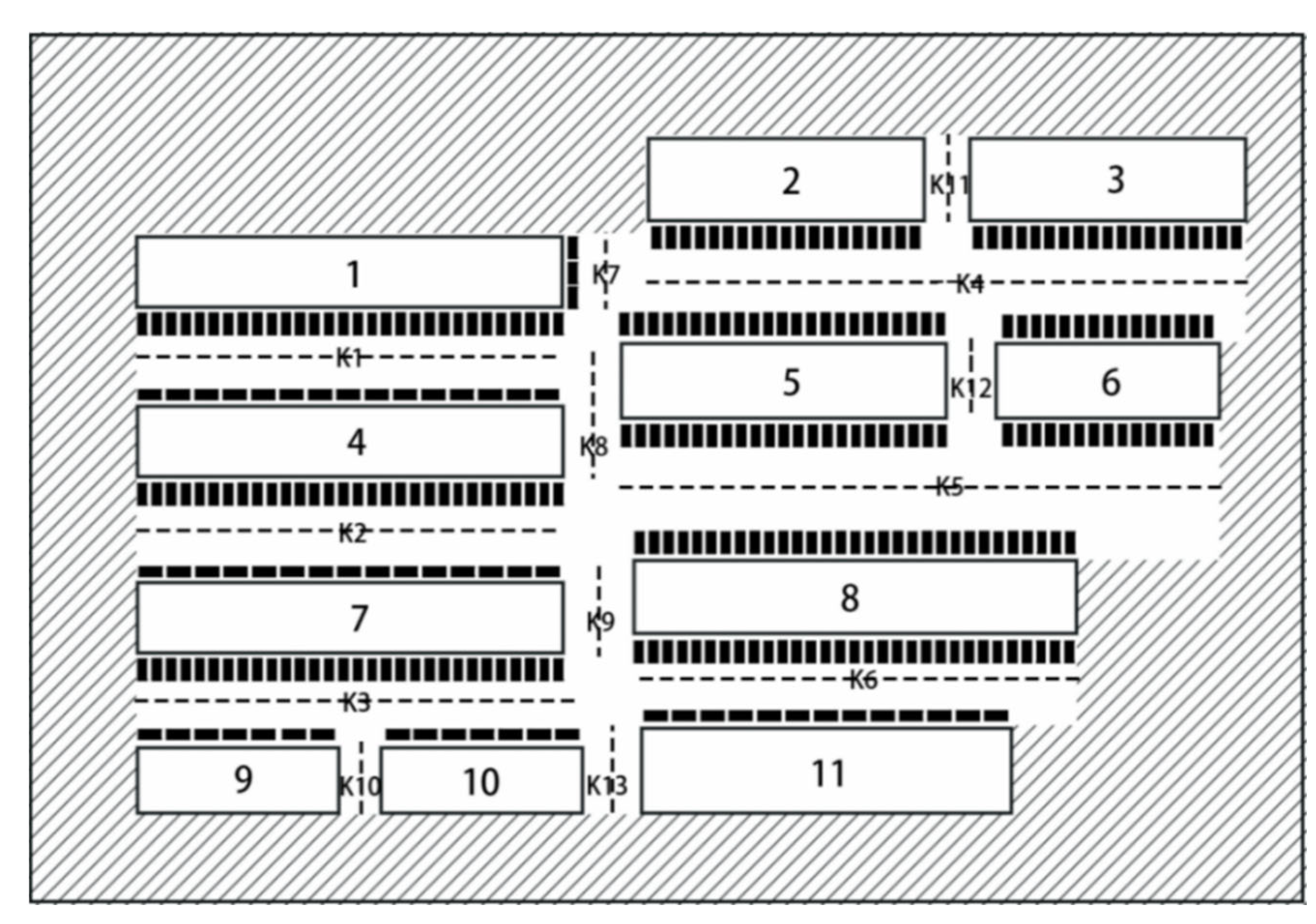
4.2.3. Plane Map
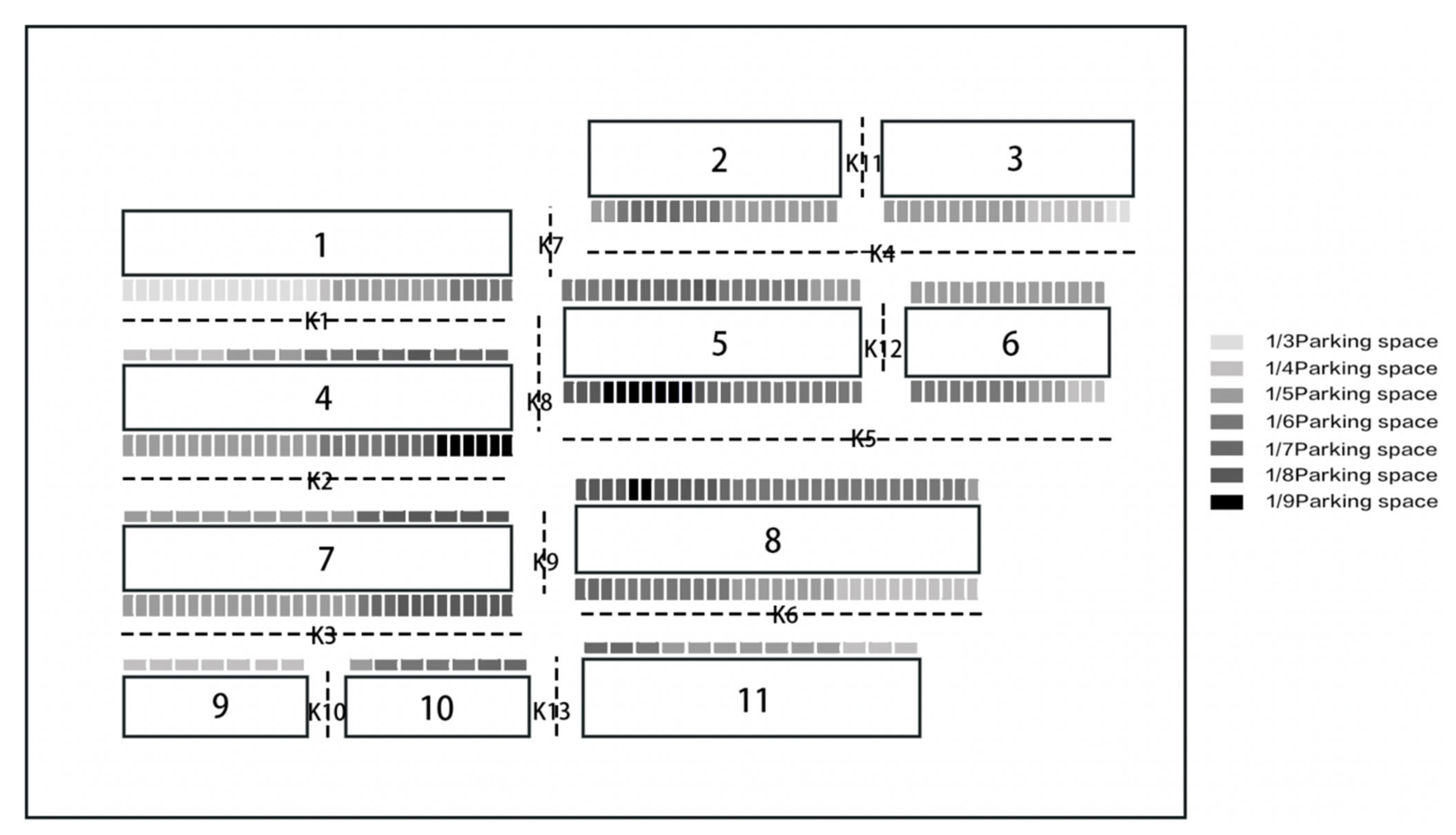
4.3. The Layout of the Maximum Parking Space in the Study Area
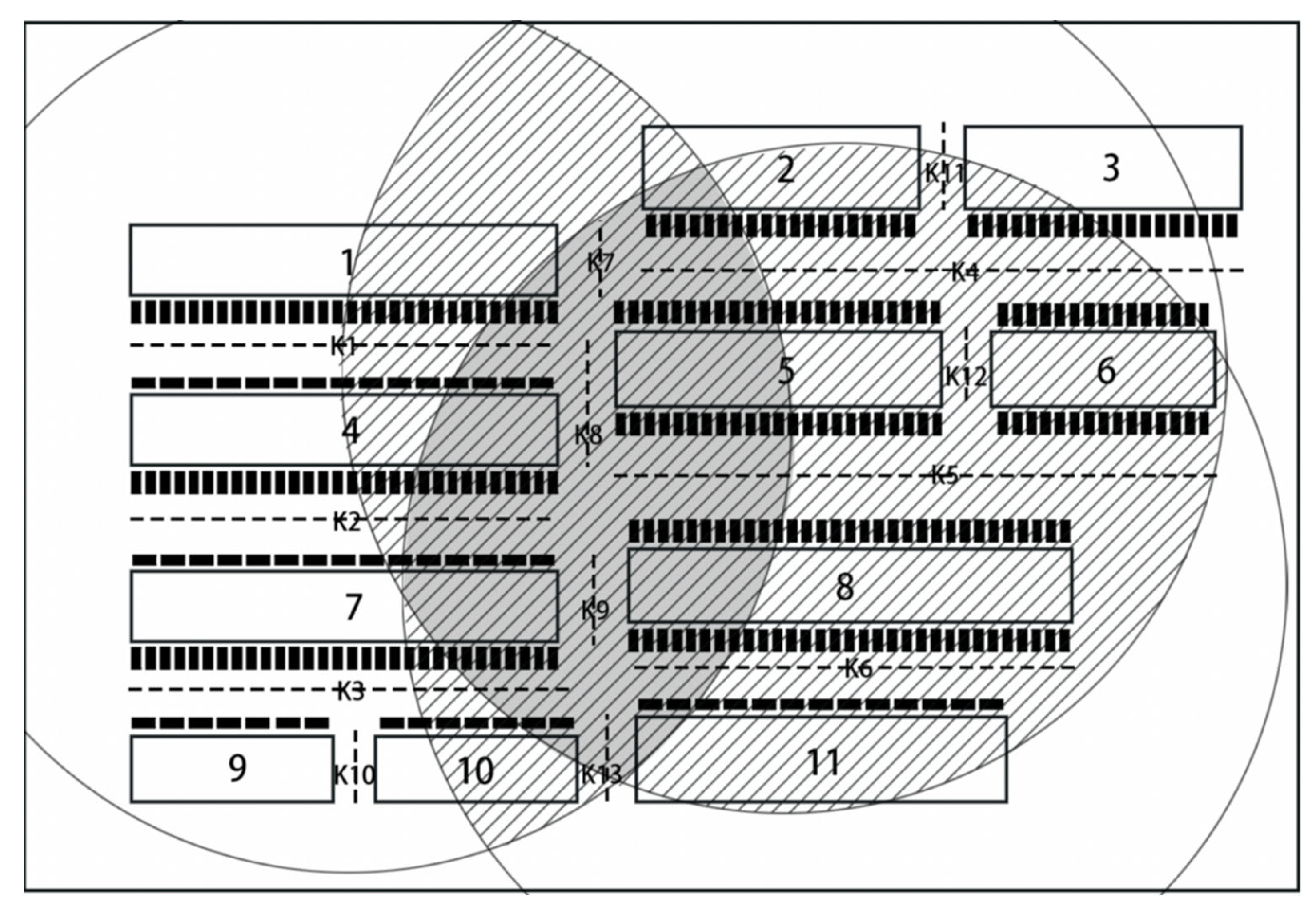
4.4. The Layout of the Accessible Parking Space in the Study Area
4.5. Layout Planning of Multi-Layer Parking Equipment in the Study Area
5. Conclusions
- (1)
- Multi-scale segmentation and image extraction of satellite images in the study area are carried out through object-oriented technology, combined with the characteristics of the image and feature types in the study area, so that the similar surface information in the image can be classified and merged;
- (2)
- Based on the results of classification and extraction of feature information in the study area, the edge of the image contour is regularized to obtain a planar map of the area. This information graph is the basis of this article’s parking equipment planning and design evaluation model;
- (3)
- From the perspective of science, the influencing factors of parking space layout are divided into two aspects: rationality and suitability, and an evaluation model for parking equipment planning and design is proposed. The rationality is to carry out the research from the physical and objective aspects, comprehensively consider the environmental conditions in the research area, and plan the layout of the maximum capacity of parking spaces in the research area. The suitability is based on the study of parking demand. On the basis of the maximum capacity layout planning of parking spaces, the accessibility parking space planning and the layout design of multi-storey parking equipment are carried out.
- (4)
- The feasibility of the evaluation model for the planning and design of parking equipment is verified by an actual case. Based on the acceptable pick-up distance and time, and considering the surface information of parking area and the rationality and suitability of parking layout, the specific planning and design is carried out including of the type, quantity and location of parking equipment.
- (5)
- The object image technology is used in the map extraction of the evaluation model of parking equipment planning and design proposed in this paper. This technology has fast recognition speed and low cost. It is a valuable planning map extraction method, which can provide a powerful reference for parking planning and design. However, due to the influence of sampling image accuracy and classification objects, the accuracy of object-oriented technology still needs to be further improved.
Author Contributions
Funding
Conflicts of Interest
References
- Abdelfatah, A.S.; Taha, M.A. Parking capacity optimization using linear programming. J. Traffic Logist. Eng. 2014, 3, 176–183. [Google Scholar] [CrossRef] [Green Version]
- Azevedo, J.; D’Orey, P.M.; Ferreira, M. High-Density Parking for Automated Vehicles: A Complete Evaluation of Coordination Mechanisms. IEEE Access 2020, 8, 43944–43955. [Google Scholar] [CrossRef]
- Dianawati, F.; Kristianto, J. Rest Area Parking Design Using Integer Linear Programming. In Proceedings of the 2019 5th International Conference on Industrial and Business Engineering, Hong Kong, China, 27–29 September 2019; pp. 218–222. [Google Scholar] [CrossRef]
- Banzhaf, H.; Quedenfeld, F.; Nienhuser, D.; Knoop, S.; Zollner, J.M. High density valet parking using k-deques in driveways. In Proceedings of the 2017 IEEE Intelligent Vehicles Symposium (IV), Los Angeles, CA, USA, 11–14 June 2017; pp. 1413–1420. [Google Scholar] [CrossRef]
- Zou, M.; Wang, Q.; Liu, S.-A. Optimization of Parking Space Allocation for Automated Parking System of Paternoster Type by Genetic Algorithm. In Proceedings of the 2019 Chinese Control and Decision Conference, Nanchang, China, 3 June 2019; pp. 3834–3838. [Google Scholar] [CrossRef]
- Sawangchote, P.; Yooyativong, T. Automated Parking Area Optimization for Garage Construction using Geometric Algo-rithm. Icdamt: Digital Economy for Sustainable Growth. In Proceedings of the 2017 International Conference on Digital Arts, Media and Technology (ICDAMT), Chiang Mai, Thailand, 1–4 March 2017; pp. 286–290. [Google Scholar]
- Ramli, M.; Sary, D.P.; Halfiani, V. Optimization model of parking charge and income using Lagrange multiplier method. In Proceedings of the 2nd International Conference on Mathematics, Engineering and Industrial Applications, Medan, Indonesia, 21–23 August 2017; Volume 1775, p. 030034. [Google Scholar] [CrossRef]
- Syahrini, I.; Sundari, T.; Iskandar, T.; Halfiani, V.; Munzir, S.; Ramli, M. Mathematical Model of Parking Space Unit for Triangular Parking Area. In Proceedings of the 4th International Conference on Operational Research (Interior), Banda Aceh, Indonesia, 19–20 September 2018; Volume 300, p. 012012. [Google Scholar]
- Guo, T.; Yang, J.; He, L.; Tang, K. Emerging Technologies and Methods in Shared Mobility Systems Layout Optimization of Campus Bike-Sharing Parking Spots. J. Adv. Transp. 2020, 2020, 1–10. [Google Scholar] [CrossRef]
- Han, Y.; Shan, J.; Wang, M.; Yang, G. Optimization design and evaluation of parking route based on automatic assignment mechanism of parking lot. Adv. Mech. Eng. 2017, 9. [Google Scholar] [CrossRef]
- Qin, H.; Gao, J.; Zhang, G.; Chen, Y.; Wu, S. Nested logit model formation to analyze airport parking behavior based on stated preference survey studies. J. Air Transp. Manag. 2017, 58, 164–175. [Google Scholar] [CrossRef]
- Shi, Y.; Pan, Y.; Sun, X.; Xie, R.; Chen, W.; Shen, S. Collaborative Planning of Parking Spaces and AGVs Path for Smart Indoor Parking System. In Proceedings of the 2018 IEEE 22nd International Conference on Computer Supported Cooperative Work in Design (CSCWD), Nanjing, China, 9–11 May 2018; pp. 869–871. [Google Scholar] [CrossRef]
- Feret, T.; Chandrashekhariah, P.; Trujillo, N. Real-time Parking Slot Detection for Camera-equipped Vehicles. In Proceedings of the 2019 IEEE Intelligent Transportation Systems Conference (ITSC), Auckland, New Zealand, 27–30 October 2019; pp. 4107–4114. [Google Scholar] [CrossRef]
- Hsu, C.-M.; Chen, J.-Y. Around View Monitoring-Based Vacant Parking Space Detection and Analysis. Appl. Sci. 2019, 9, 3403. [Google Scholar] [CrossRef] [Green Version]
- Mettupally, S.N.R.; Menon, V. A Smart Eco-System for Parking Detection Using Deep Learning and Big Data Analytics. In Proceedings of the 2019 SoutheastCon, Huntsville, AL, USA, 11–14 April 2019. [Google Scholar]
- Nourinejad, M.; Bahrami, S.; Roorda, M.J. Designing parking facilities for autonomous vehicles. Transp. Res. Part B Methodol. 2018, 109, 110–127. [Google Scholar] [CrossRef]
- Sun, X.; Zhao, Y.; Shen, S.; Wang, K.; Zheng, X.; Shi, Y. Scheduling Multiple AGVs with Dynamic Time-windows for Smart Indoor Parking Lot. In Proceedings of the 2018 IEEE 22nd International Conference on Computer Supported Cooperative Work in Design (CSCWD), Nanjing, China, 9–11 May 2018; pp. 864–868. [Google Scholar] [CrossRef]
- Zhang, Y.; Huang, Y.; Tan, K. Change detection of urban typical features based on multi-classifier integration and object—Take, for example, ZY-3 images. Geogr. Geogr. Inf. Sci. 2018, 34, 54–60, 130. [Google Scholar]
- Gui, H.; Feng, W.; Li, W. A survey of multi-temporal remote sensing image change detection methods. J. Wuhan Univ. (Inf. Sci.) 2018, 43, 1885–1898. [Google Scholar]
- Li, Q.; Zhang, J.; Niu, R. Rapid extraction of damaged roads from remote sensing images based on GIS and object-oriented method. Surv. Mapp. Bull. 2015, 4, 78–81. [Google Scholar]
- Dai, L.; Li, H.; Gu, H. Construction of object-oriented classification rules for remote sensing image based on feature selection. Surv. Sci. 2019, 44, 26–32. [Google Scholar]
- Li, H.; Xu, F.; Weng, X. Recognition method for high-resolution remote-sensing imageries of ionic rare earth mining based on object-oriented technology. Arab. J. Geosci. 2020, 13, 1–11. [Google Scholar] [CrossRef]
- Yang, J.; Wan, J.; Ma, Y.; Hu, Y. Research on object-oriented decision fusion for oil spill detection on sea surface. In Proceedings of the International Geoscience and Remote Sensing Symposium, Yokohama, Japan, 28 July–2 August 2019; pp. 9772–9775. [Google Scholar]
- Sun, Z.-P.; Liu, S.; Cao, F.; Shi, Y.; Wang, C.-Z. Fine classification of construction land using high-resolution remote sensing images: A case study in planning restricted zone of nuclear power plant. Arab. J. Geosci. 2017, 10, 495. [Google Scholar] [CrossRef]
- Lin, Q.; Zou, Z.; Lin, L.; Wang, Y.; Mikos, M.; Tiwari, B.; Yin, Y.; Sassa, K. Combining Spectral and Morphometric Properties of Landslides for Separating Individual Landslides Based on Object-Oriented Method. Adv. Cult. Living Landslides Adv. Landslide Sci. 2017, 2, 61–70. [Google Scholar] [CrossRef]
- Fathizad, H.; Ardakani, M.A.H.; Mehrjardi, R.T.; Sodaiezadeh, H. Evaluating desertification using remote sensing technique and object-oriented classification algorithm in the Iranian central desert. J. Afr. Earth Sci. 2018, 145, 115–130. [Google Scholar] [CrossRef]
- Merchant, M.A. Classifying open water features using optical satellite imagery and an object-oriented convolutional neural network. Remote Sens. Lett. 2020, 11, 1127–1136. [Google Scholar] [CrossRef]
- Moreno, A.J.P.; Ureña, M.J.A.; De Larriva, J.E.M.; Agugliaro, F.M. Empleo De La Fotogrametría Digital Para La Evaluación Del Suelo Con Riesgo De Erosión En Olivar. DYNA Ing. E. Ind. 2017, 92, 55–62. [Google Scholar] [CrossRef]
- Tuno, N.; Elezović, A.; Topoljak, J.; Mulahusić, A. Ispitivanje položajne točnosti granica šumskih područja dobivenih objektno—orijentiranom klasifikacijom multispektralnih snimaka. Sumar. List 2017, 141, 29–38. [Google Scholar] [CrossRef] [Green Version]
- Yang, B.; Wang, S.; Zhou, Y.; Wang, F.; Hu, Q.; Chang, Y.; Zhao, Q. Extraction of road blockage information for the Jiuzhaigou earthquake based on a convolution neural network and very-high-resolution satellite images. Earth Sci. Inform. 2019, 13, 115–127. [Google Scholar] [CrossRef]
- Yan, S.; Cao, Y.; Ge, X. Application of object-oriented information extraction technology of remote sensing image in GIS Land Management. Surv. Sci. 2013, 38, 93–95. [Google Scholar]
- Tao, G.; Liu, Y. Extraction and analysis of urban housing information based on object-oriented high-score image. Electron. Technol. Softw. Eng. 2019, 9, 76–78. [Google Scholar]
- Gong, L.; Li, Q.; Zang, J. Object-oriented method for detecting seismic damage change of buildings. Earthquake 2013, 33, 109–114. [Google Scholar]
- Di, R.; Fu, B.; Cai, J. Vegetation identification of karst wetland based on UAV image and object-oriented stochastic forest algorithm. J. Earth Inf. Sci. 2019, 21, 1295–1306. [Google Scholar]
- Liu, G. Methodology of Natural Science; Shanghai People’s Fine Arts Publishing House: Shanghai, China, 2018. [Google Scholar]
- What Is the Standard Size of the Parking Lot. Available online: http://www.360doc.com/content/15/0406/16/2472300_461039170.shtml (accessed on 6 April 2015).
- Out of Every 100 People Own a Car, so Is It Really Widespread. Available online: https://new.qq.com/omn/20210221/20210221A0ATPL00.html (accessed on 21 February 2021).
- A Normal Adult Walks at a Normal Speed, about How Many Kilometers an Hour. Available online: https://zhidao.baidu.com/question/919949362266347219.html (accessed on 2 August 2020).
- Grading and Width of Residential Roads. Available online: https://zhidao.baidu.com/question/384397733.html (accessed on 24 March 2019).
- Huang, S.; Wang, J.; Li, G. Application of GIS technology in the site selection of urban public parking lots—A case study of Changchun high-tech development zone. Transp. Eng. 2018, 18, 22–27. [Google Scholar]


| K | Diagram of Layout Planning |
|---|---|
| K < K0 + 2.5 |  |
| K0 + 2.5 ≤ K < K0 + 5 |  |
| K0 + 5 ≤ K < K0 + 7.5 |  |
| K0 + 7.5 ≤ K < K0 + 10 | 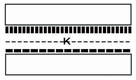 |
| K0 + 10 ≤ K |  |
| Building | 1 | 2 | 3 | 4 | 5 | 6 | 7 | 8 | 9 | 10 | 11 |
|---|---|---|---|---|---|---|---|---|---|---|---|
| Length/m | 75 | 48 | 48 | 75 | 58 | 39 | 75 | 78 | 35 | 35 | 65 |
| Width/m | 15 | 18 | 18 | 15 | 17 | 17 | 15 | 15 | 13 | 13 | 16 |
| Number of residents | 193 | 137 | 134 | 204 | 172 | 122 | 177 | 221 | 99 | 115 | 151 |
| Building Spacing | K1 | K2 | K3 | K4 | K5 | K6 | K7 | K8 | K9 | K10 | K11 | K12 | K13 |
|---|---|---|---|---|---|---|---|---|---|---|---|---|---|
| Width/m | 18 | 18 | 18 | 21 | 24 | 18 | 13 | 9 | 10 | 8 | 8 | 9 | 10 |
| Building | 1 | 2 | 3 | 4 | 5 | 6 | 7 | 8 | 9 | 10 | 11 |
|---|---|---|---|---|---|---|---|---|---|---|---|
| Parking Demand | 35 | 25 | 25 | 37 | 31 | 22 | 32 | 40 | 18 | 21 | 27 |
| Building | 1 | 2 | 3 | 4 | 5 | 6 | 7 | 8 | 9 | 10 | 11 |
|---|---|---|---|---|---|---|---|---|---|---|---|
| Available Parking Space | 29 | 28 | 21 | 34 | 31 | 30 | 33 | 38 | 19 | 26 | 24 |
| Building | 1 | 2 | 3 | 4 | 5 | 6 | 7 | 8 | 9 | 10 | 11 |
|---|---|---|---|---|---|---|---|---|---|---|---|
| Plan the number of double-layer stereo parking equipment | 49 | 53 | 26 | 51 | 66 | 35 | 43 | 66 | 21 | 41 | 52 |
| Available double-layer stereo parking equipment | 6 | 6 | 4 | 6 | 8 | 4 | 5 | 8 | 2 | 5 | 6 |
| Parking Demand | 35 | 25 | 25 | 37 | 31 | 22 | 32 | 40 | 18 | 21 | 27 |
| Available parking spaces before planning | 29 | 28 | 21 | 34 | 31 | 30 | 33 | 38 | 19 | 26 | 24 |
| Available parking spaces after planning | 35 | 34 | 25 | 40 | 39 | 34 | 38 | 46 | 21 | 31 | 33 |
Publisher’s Note: MDPI stays neutral with regard to jurisdictional claims in published maps and institutional affiliations. |
© 2021 by the authors. Licensee MDPI, Basel, Switzerland. This article is an open access article distributed under the terms and conditions of the Creative Commons Attribution (CC BY) license (https://creativecommons.org/licenses/by/4.0/).
Share and Cite
Ni, M.; Sun, Z.; Luo, Y.; Yi, Q.; Zhang, Y.; Wang, Z. Evaluation Model of Parking Equipment Planning and Design Based on Object-Oriented Technology. Appl. Sci. 2021, 11, 4263. https://doi.org/10.3390/app11094263
Ni M, Sun Z, Luo Y, Yi Q, Zhang Y, Wang Z. Evaluation Model of Parking Equipment Planning and Design Based on Object-Oriented Technology. Applied Sciences. 2021; 11(9):4263. https://doi.org/10.3390/app11094263
Chicago/Turabian StyleNi, Minna, Zhihong Sun, Yuhan Luo, Qi Yi, Yiqing Zhang, and Zhongyi Wang. 2021. "Evaluation Model of Parking Equipment Planning and Design Based on Object-Oriented Technology" Applied Sciences 11, no. 9: 4263. https://doi.org/10.3390/app11094263