Featured Application
This paper presents a real implementation at the national level of a Geographic Information System (GIS)-based expert system used for historic cultural record keeping
and archeological heritage protection. The project is publicly available at www.archterr.ro and
was supported by a grant from the Romanian Ministry of Research and Innovation.
Abstract
This paper presents the results of an experimental-demonstrative research project summarizing three integrated products: an interactive digital map; a reference and record keeping database system; and a set of procedures to enforce the unified application of archaeological heritage
protection legislation in Romania. The web-based application constitutes a permanent working
tool available to the Romanian Ministry of Culture territorial branch offices, and is freely accessible
to specialists and other entities involved in the protection of archaeological heritage, and even to
private investors interested in development on land areas having archaeological heritage. The
application brings together the organization, systematization, and digitization of all available information about archaeological sites at the national level. This information is otherwise difficult to
access because it is structured differently in terms of quantity and quality of data, and stored using
different media and formats in several types of non-interconnected institutions. The ArchTerr
application significantly reduces the time required to inform, verify, and communicate a decision
regarding the presence or absence of archaeological heritage on a particular site. The application
ensures the dynamic and automatic real-time bidirectional conversion of geospatial information
(Stereo70 and WGS84), and access to unitary and level-structured information, and provides interoperability with other information systems. High-resolution maps allow the non-professional
user/investor to access detailed geospatial information about a delimited area, in a timely manner
and without the need for field travel, which is a unique feature not found in other European record
systems concerning archeological sites. The functionalities of the application developed within the
research project, the technical decisions taken, and their implementation method are generally
valid. They can be applied in any geographical region because the open source maps used by the
technical team cover the world map and the coordinate system used for representation is international. The testing and validation of these functionalities were undertaken using real archaeological
data from Romania (data already included in the national heritage representing archaeological
sites).
1. Introduction
The ArchTerr project web application is an IT product designed and implemented as a result of the collaboration of two universities (“Dunarea de Jos” University of Galati and “Politehnica” University of Bucharest) in the project “Integrated management of archaeological heritage: archaeological map and administrative procedures for heritage research and protection” funded by the Executive Unit for the Financing of Higher Education, Research, Development and Innovation (UEFISCDI) in Romania, within the competition organized for subprogram 2.1. Competitiveness through research, development and innovation, funding instrument Experimental Demonstration Project (PED) in 2019. This project ran between 2020 and 2022 [1,2,3].
The design of this IT product responds to the need to gather information (scientific or administrative in nature) regarding the discovery of archaeological remains, accumulated over time and in various forms at the level of various national and local institutions (the Ministry of Culture and its subordinate institutions for the National Heritage Institute, museums, research institutes in the field, universities, territorial administrative units, and cadastral offices). This information is then made available in an immediately accessible form, available to both institutions involved in the management and protection of the archaeological heritage, and to the general public, thus enabling this non-renewable resource to be included in sustainable local development projects. Due to this information, products (i.e., the digital interactive map interconnected with a database that accumulates complex information about each archaeological site) are brought to the attention of the involved institutions, in addition to possible investors (public or private legal entities or individuals). Thus, information is constantly updated, and descriptively and geospatially documented, regarding the archaeological potential of a certain land area, in a unitary database organized at the level of each administrative-territorial unit.
The ArchTerr web application is mainly managed by Ministry of Culture territorial branch offices at each administrative structure (county) and monitored at the central level by the specialized structure within the Ministry of Culture. Moreover, any entity or person interested from a scientific, administrative, or investment perspective can consult the map and the adjacent database, and can directly check, by entering the geospatial coordinates of the land area of interest, regardless of whether it is inside or near an archaeological site. Following this consultation, the interested parties are provided with the administrative procedures for the protection of the archaeological heritage for each case.
2. Background
The two interconnected tools—the interactive archaeological map and the database—support the effort to protect the archaeological heritage as part of the national cultural heritage, as inscribed in the national defense strategy of Romania [4] and defined in the international conventions applicable to it: the International Charter for the Conservation and Restoration of Monuments and Sites—The Venice Charter 1964 [5], the European Convention for the Protection of Archaeological Heritage ETS no. 066—London Convention 1969 [6], the Charter for the Protection and Management of Archaeological Heritage (Lausanne, 1990) [7], the European Convention for the Protection of Archaeological Heritage (revised), (Valletta, 1992) [8], The European Landscape Convention (Florence, 2000) [8], and the Convention on the Value of Cultural Heritage for Society (Faro Convention, 2005) [9]. Archaeological heritage is a resource of national identity that is finite and non-renewable [10], and vulnerable to the trends of accelerated economic development of society and real estate [11,12]. The ArchTerr web application is a necessary tool for the management of integrated archaeological heritage, in line with international changes in its protection [13].
At the European level, from the second half of the twentieth century, fundamental changes occurred in the management of archaeological heritage through the emergence of new strategies for collecting evidence, conservation, and research: “systematic archeology” (research of a site for a number of years, exclusively for scientific and didactic purposes, and possibly for the general public) has passed into the background, with the main position being occupied by archeology determined by investments in infrastructure and real estate. This activity is designated in its first stage with the terms “rescue archeology”, “salvage archeology” (English), and “archéologie de sauvetage” (French), which describe situations in which the archaeological research is carried out in areas having archaeological heritage, and where constructive interventions are to be carried out to prevent the total destruction of the archeological vestiges that appeared during such works [14].
Awareness of the need to prevent the destruction of archaeological heritage prior to carrying out an investment project has led to the formulation of the concept of “preventive archeology” [15], which is expressed in the variants “development-lead archeology”, “development founded archeology”, “contractual archeology”, etc. This new concept involves carrying out specific activities of identification, evidence collection, primary documentation (bibliographic and field), actual research (excavation), restoration and conservation of artifacts and remains, scientific documentation, and dissemination of research results. In addition, at the same time, it involves administrative measures to exhaustively save the archaeological information and to protect the archaeological remains, prior to the constructive intervention [16,17,18,19]. During the past 20 years, this type of archaeological activity has become dominant in Romania [20].
The joint management of the two types of resources (natural heritage and cultural heritage) has led to the formulation and implementation of the concepts of “cultural resource management”, “cultural resource management archeology”, “archaeological resource management”, and “archaeological heritage management” [14,21,22,23]; these concepts are included in all international policies and recommendations of good practice. The protection of the archaeological heritage is increasingly seen as a matter of public interest, and must be managed from the perspective of sustainable community development [23,24,25,26].
In the effort to protect the archaeological heritage, the idea of “protection of the archaeological heritage through documentation” appears as a vital idea at the international level, imposing concepts such as: “preservation by record”, “mitigation through data recovery”, and “sauvegarder par l‘étude” (French) [14]. This approach has led to a rethinking of how to conduct archaeological research, from classical excavation to the use of non-intrusive investigation techniques, such as geomagnetism, aerial photography, LIDAR, 3D scanning, and GIS, in order to obtain coherent and effective evidence [27,28,29,30].
It is known that any archaeological research is destructive, and any area having unexplored archaeological heritage in which investment is made without the prior release of the archaeological site deprives interested parties of the related knowledge. Thus, in the field of essential information, an adequate record and documentation of archaeological remains must allow the accumulation of information about each site/discovery that is as consistent as possible. This documentation must be produced and stored in digital format, and be easy to find and publicly accessible, thus forming the basis for establishing any national and sectoral strategy for managing archaeological data and information with the aim of highlighting the revealed remains.
In this context, most countries with a tradition in the field of archaeological heritage protection have developed systems for recording archaeological heritage. Some of these represent a reference and are listed in the following sections.
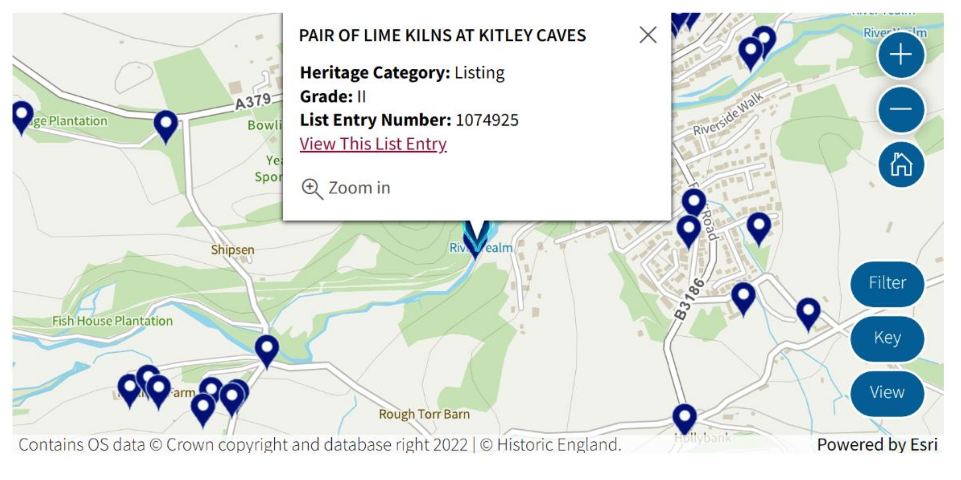
In the UK, the institutions responsible for protecting the built heritage (including the archaeological heritage)—the English Heritage government agency, the Association of Local Government Archaeological Officers, and the Institute of Historic Building Conservation—have initiated and manage the Heritage Gateway website [31]. Since 1981, this site has stored, and made available to the public, detailed information on the objectives of the UK’s historical and archaeological heritage (Figure 1).

Figure 1.
UK Heritage Gateway web site: example of how to identify a historical monument “Pair of Lime Kilns at Kitley Caves” on the digital map associated with the database.
Unitary built heritage management systems have also been developed in Scotland and Wales. In Scotland, the Computer Application for the National Monuments Record Enquiries (CANMORE) system comprises a database, a geographic information system, and an archive [32]. In Wales, The Online Catalog of Archaeological Sites, Historic Buildings, Industrial and Maritime Heritage in Wales (COFLEIN) application [33] has the same structure: a historical heritage database (archaeological included), a documentary archive, and a digital map. In both cases the information can be viewed online.
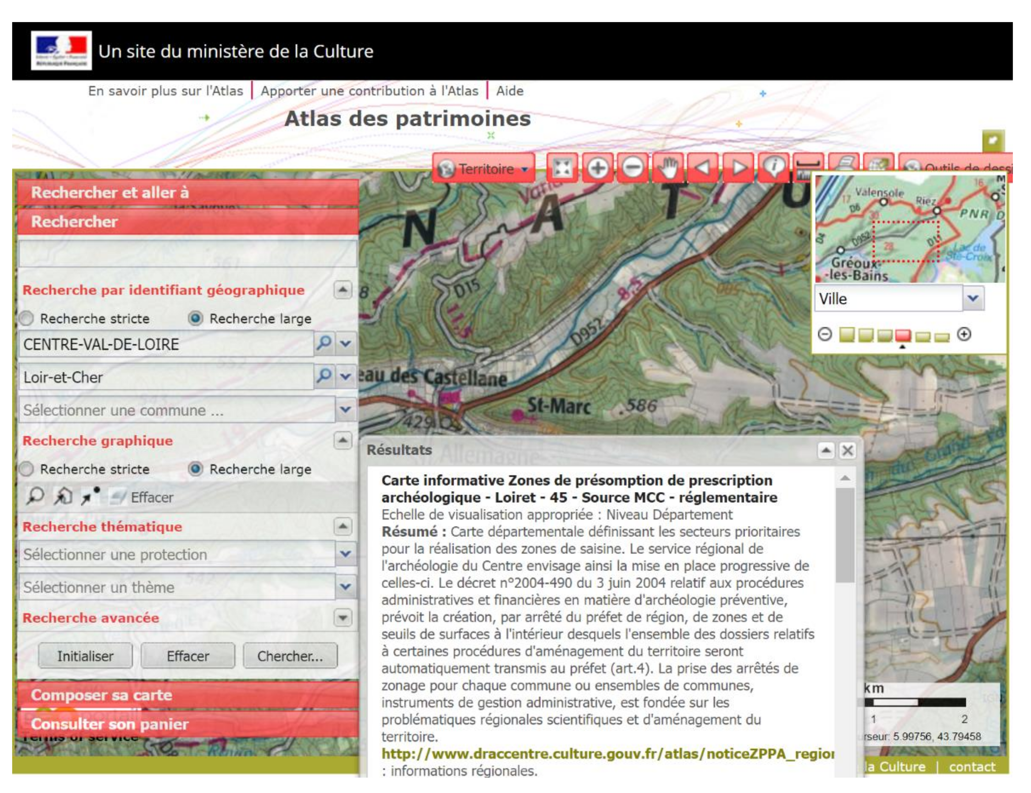
In France, there are two tools: la carte archéologique nationale [34], which is a cartographic inventory of archeological sites and discoveries; and the database called “L‘Atlas des patrimoines” [35], managed by the Ministry of Culture through the regional archeology services (Les Directions Régionales des Affaires Culturelles). Access to these documentation tools is available to the public (Figure 2).
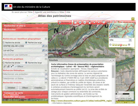
Figure 2.
France Atlas des patrimoines: the search result for historical monuments in “Centre Val de Loire” geographical area.
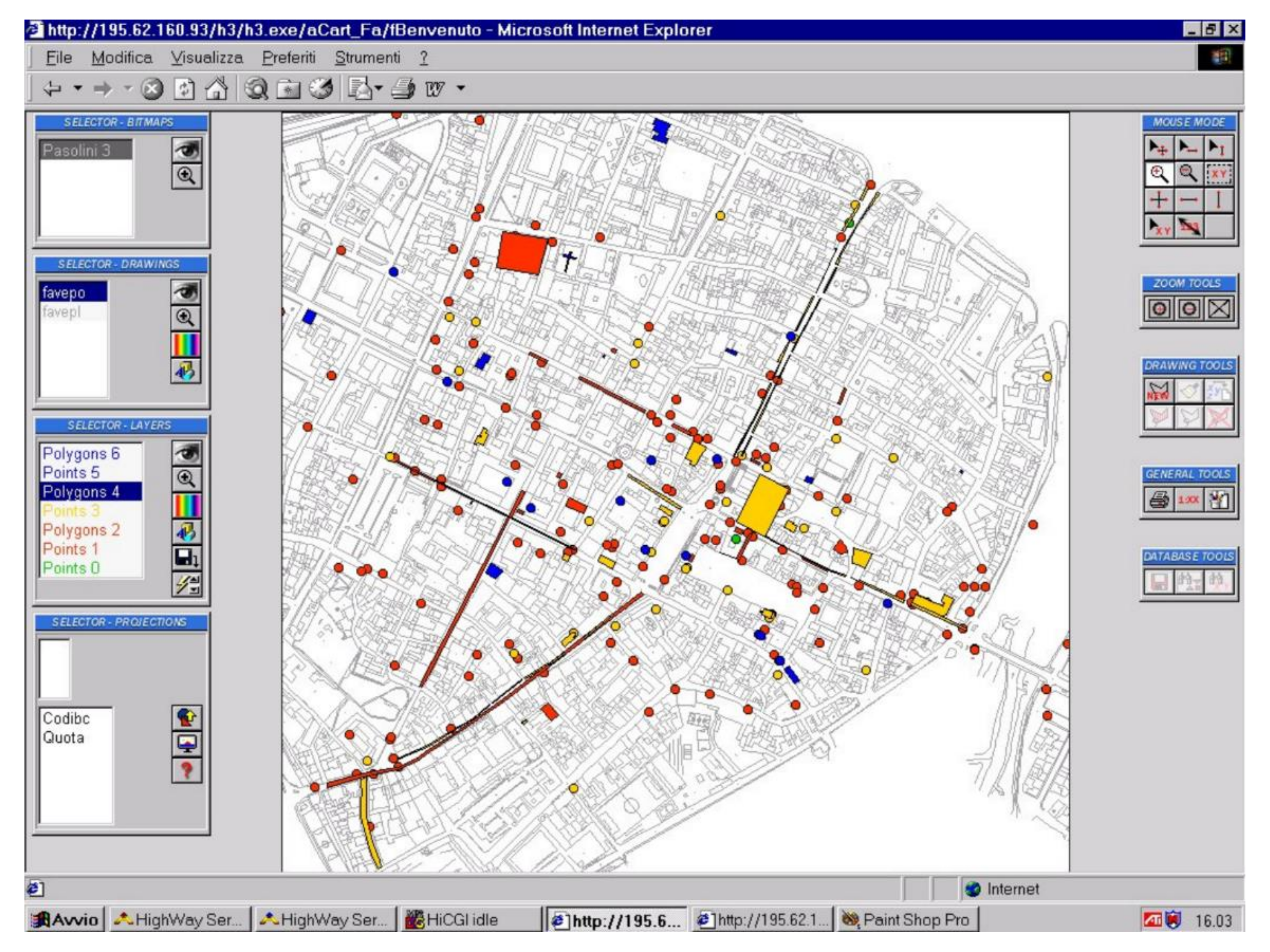
The system of evidence and management of the archaeological heritage implemented in Italy, since 1995, is called C.A.R.T.—Archaeological map of territorial risk [36] (Figure 3). This is a source of knowledge, enabling protection of the archaeological heritage as support for the programming of any intervention in the territory [37,38,39].
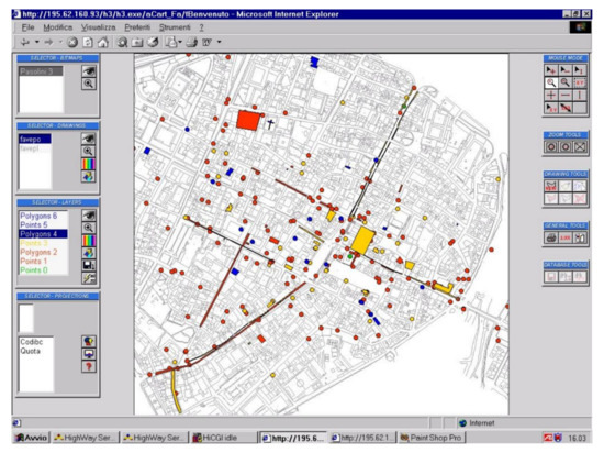
Figure 3.
Italy C.A.R.T. project: graphic illustration of how to present information on the map through polygons of different colors using Odysseus software.
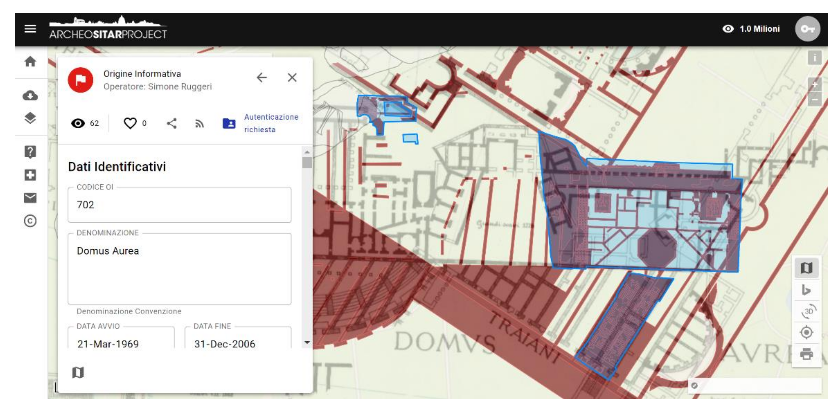
Another example in Italy, Il Sistema Informativo Territoriale Archeologico di Roma (SITAR), is an integrated system for managing issues related to the archaeological heritage of Rome using the webGIS platform. It brings together all the information available to the Soprintendenza Speciale Archeologia Belle Arti e Paesaggio di Roma, and is accessible online by the general public [40,41] (Figure 4).
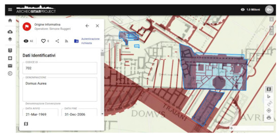
Figure 4.
Italy SITAR project: graphic illustration of “Domus Aurea” on the map associated with the database.
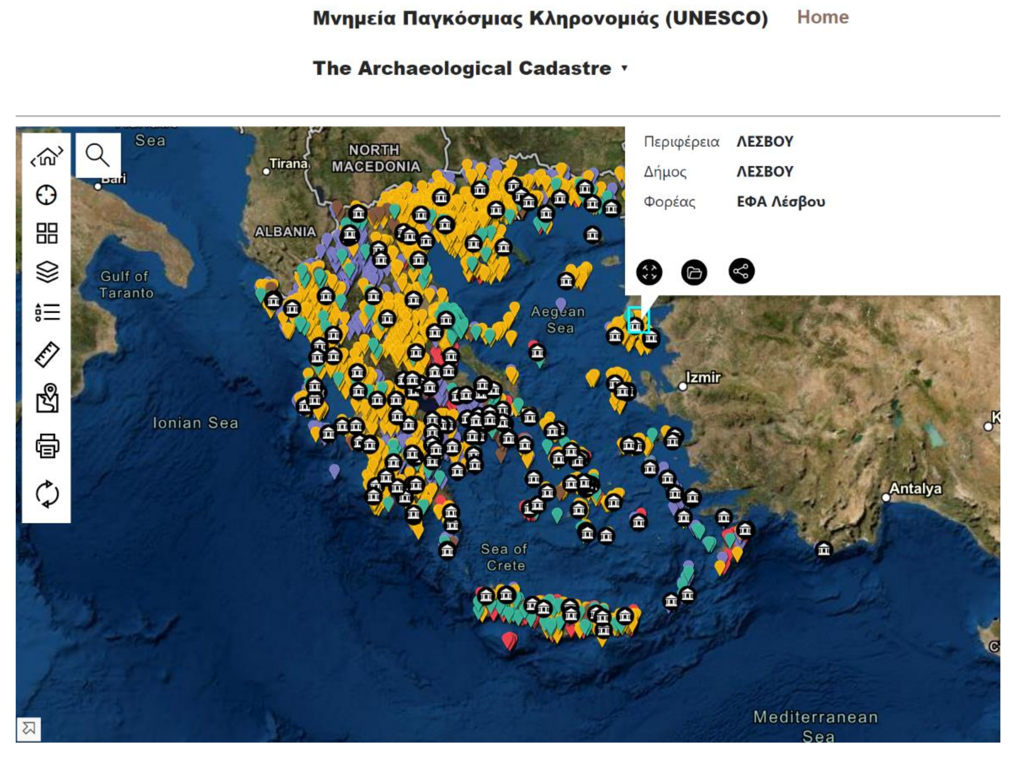
In 2021, Greece made available to the public The Archaeological Cadastre Portal [42], which is an integrated information system for evidence storage, documentation, and management of national heritage (Figure 5).
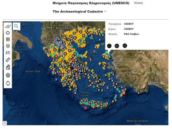
Figure 5.
Greece The Archaeological Cadastre Portal: screenshot showing different types of monuments and archaeological sites.
There are different approaches in this area in Spain, following the transfer of competences in the field of conservation of the archaeological heritage to the regions. In this context, the Information System on the Archaeological Heritage of Andalusia (SIPAA), called ARQUEOS, was initiated in 1989. This system is accessible by the public [43,44] and is required as a model.
Efforts to provide evidence of archaeological heritage are also made in the European countries of the former communist bloc, although results are still modest (see the cases of Hungary, Romania, etc.) [45,46].
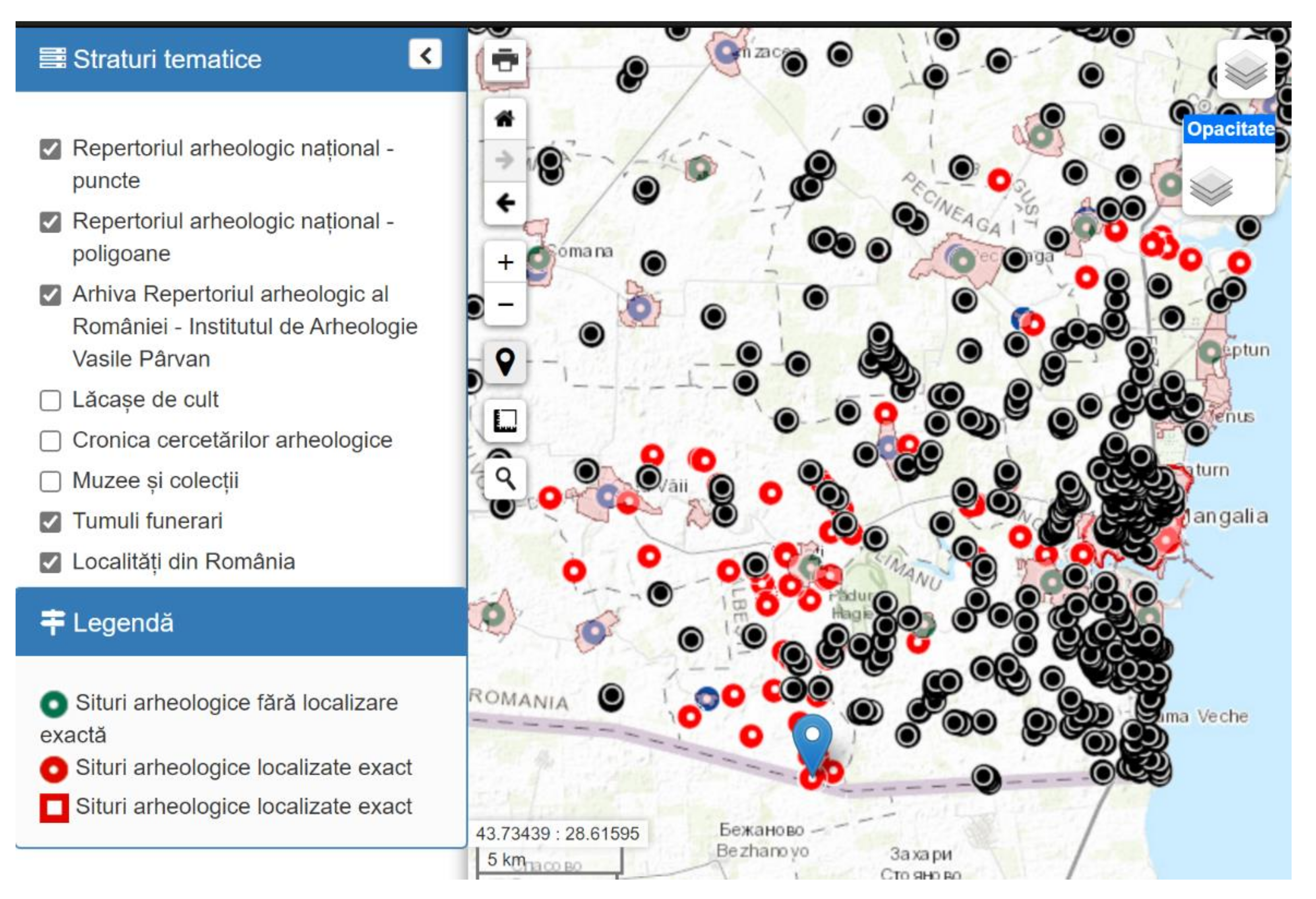
In Romania, the Ministry of Culture initiated two databases that aimed to record the archaeological heritage: the National Archaeological Repertory (R.A.N.; 2004) [47] (Figure 6); and the National Program for the Implementation of a Geographic Information System (GIS) for the protection of the immovable cultural heritage (archeology and historical monuments) (eGISPat; 2006–2013) [48,49,50]. The administration mode of the R.A.N., centralized by the Ministry of Culture through the National Institute of Heritage, and without the direct involvement of the Ministry of Culture territorial branch offices, determined that the number of registered sites should be reduced, some without a geospatial location, with a series of errors and inconsistencies. In addition, the poor management of the implementation of the eGISPat program at the national level meant that the program did not achieve the expected outcome; the program was implemented only at the level of 8 of the 41 territorial structures, and the general situation was rather dysfunctional [14].

Figure 6.
Romania, the R.A.N. website: screenshot with archaeological sites represented (“burial tumulus” type).
As a result, the research project outcome, namely the ArchTerr web application, is a necessity in the context of the new orientation for the protection of archaeological heritage.
The project through which the ArchTerr application was built was financed from public funds. The aim was to build a software application to help protect the archaeological heritage in Romania (Figure 7) which, by its geographic positioning, was at the confluence of several civilizations during history.
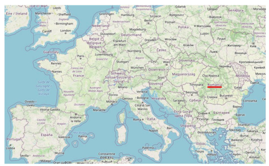
Figure 7.
Europe map highlighting the territory (Romania) where the ArchTerr project pilot phase was implemented.
In the process of testing and validating this application, three counties were initially involved, through the territorial offices of the Ministry of Culture. Later, four more counties asked to be added to the project (Figure 8).
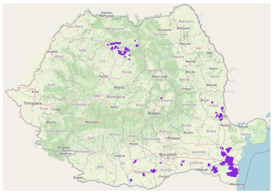
Figure 8.
ArchTerr web site application: Romania map representing the validated archeological sites (purple blocks) from the seven counties involved in the project.
3. Methods in Archeology
In the national and international context described above, the initiation of an integrated information system, managed at the territorial level by the county directorates for culture, is a necessity that can no longer be delayed. This system is consistent with other European applications built for the same purpose, and has additional, new features, as discussed below; the interactive map, database, and section of administrative procedures are presented in an accessible form, with a friendly and intuitive interface that is easy to manage by both those who are going to implement it (the county directorates for culture) and those who consult it. Access to the system is obtained differently, depending on how each user relates to it, and a three-level hierarchy was established: supervisor/manager, users who can input data/archeologist/specialist, and visiting end users.
- 1.
- Users who can enter data into the system, logged in with username and password: These users can input new archeological data using a web form, can see all the information in the system that has been validated by the supervisor, and can make corrections only to the information that was entered by them, before sending it to validation. For any change in the system to validated information, the consent of the supervisor is required.
- 2.
- The supervisor has access to all validated information and to information that is transmitted for validation. They can make corrections to the latter, and request additions, in which case they send the site card in question to the user who provided the data or validate it (in this case the information is visible to the general public).
- 3.
- End users (visitors) who wish to consult the information stored in the system for scientific or administrative purposes can do so freely, without any login credentials; they have full access to validated data. They can check on the interactive map, without the need for any login, the positioning of a land surface delimited by geographical coordinates in relation to an area having archaeological heritage.
The interactive digital map design is based on a requirement list compiled by specialists (archaeologists and officials involved in heritage protection):
- 1.
- Entry of geo-positioning data in both WGS84 format (used by international GPS) and in Stereo70 format (official system used in Romania);
- 2.
- Immediate verification of information correctness regarding the geospatial positioning of a site;
- 3.
- The possibility of correcting any errors without an additional query of the database;
- 4.
- Representation by polygons of several types of surfaces of an archaeological site: site, protection area, researched area, area without archaeological constraints;
- 5.
- The logical interconnection between the map and the database, with the possibility of easy user access to stored information (geospatial delimitation and descriptive data);
- 6.
- Marking isolated discoveries of archaeological artifacts;
- 7.
- Marking those briefly identified sites (e.g., site center coordinates);
- 8.
- Integration of data stored in other IT systems (e.g., information stored in the eGISPat system [48] from certain counties) in ArchTerr’s database system;
- 9.
- The use of the map as a tool for information and administrative decisions by any person interested in verifying the positioning of a land in relation to an archaeological site (entering geospatial coordinates, generating polygons, making comparisons and measurements, the possibility of printing the results).
Concerning the second important software product, the archeology database, the application brings together the organization, systematization, and digitization of all the information available at a time about archaeological sites in a county. This information would otherwise be difficult to access for many users because it was structured differently in terms of the quantity and quality of data, and stored in different media and formats (paper, digital, with or without geospatial location) within several types of institutions (Ministry of Culture/county directorates for culture, territorial administrative units (counties, commune, city, village), museums and research institutes, etc.), without interconnection. The description of each site in the database is based on a Site Sheet that integrates both descriptive elements used to record and classify archaeological sites as they are formulated in the official procedures of the Ministry of Culture (National Archaeological Repertory [51], and the Record Sheet and classification of archaeological sites [52]), adding new fields of a scientific and administrative nature that were absent in the two aforementioned sheets. It was taken into account that ArchTerr meets both the requirements of the scientific environment and the needs formulated by the specialized department within the county directorates for culture, so that the two aspects—the scientific and the administrative—are well represented and harmonized.
The information contained in the file thus acquires a tree structure, and is organized by categories of information, ranging from the identification data of the site and the assumption of responsibility for the correctness of the stored information, to the detailed description of the types of artifacts discovered in that site. Finally, this information constitutes a bibliographic and administrative “file” in pdf format. Each site card has a dedicated code, formed according to a certain algorithm that is based on localization (county, city, etc.) and the site’s serial number.
In addition, at the beginning of the form, the following fields are introduced: “Initiation of site file (author)” and “Validation of site file (author)”, with the intervention data generated automatically, so that each intervention in the site is performed in a responsible manner.
In order to ensure the coherence of the terms used for the name of a type of site, a historical epoch, or a category of artifacts, a consecrated name is chosen. There are also a series of fields in which the information is filled in, in the open system.
The structure of the file/database is a tree and almost exhaustive, with the data being grouped in subfields dedicated to a single category of information, so that each person who enters data into the database is “led” to provide the data of interest. To ensure the coherence of the terms used to name a type of site, a historical epoch, or a category of artifacts, etc., the method of selection from a series of predefined descriptors is used. This shortens the time needed to complete the information, and ensures its uniformity and the possibility of retrieving the information.
Each site file contains the following categories of information as attributes:
- Discovery date;
- Site category;
- Site evidence (with a radiograph over time of the documentation evidence in which it was/is included: e.g., site registered in the National Archaeological Repertory, site classified as a historical monument and inscribed in various editions of the List of Historical Monuments, site found in urban planning documents in the Archaeological Repertory of the reference county);
- Location (county/counties, commune/communes, city, village/villages, point, toponymal point);
- Site coordinates/protection zone coordinates (WGS84 coordinates and/or Stereo70 coordinates);
- Delimitation of site/protection zone (author/authors, date, delimitation method, geographical landmarks, hydrographic landmarks, road landmarks, cadastral landmarks, etc.);
- Identification status/delimitation (site) (by: surface research, rescue research, systematic research, preventive research, surveillance, archaeological diagnosis, accidental discovery, cartographic documentation, aerial photographic documentation, mention in an ancient source, mention in an epigraphic source);
- Discoveries of representative archaeological materials (ceramics, construction materials, coins, glass objects, metal objects, bone objects, flint, stone, inscriptions);
- Vestige’s preservation status;
- Impairment factors (state of conservation);
- State of knowledge/capitalization of the site;
- Site ownership regime;
- Site protection regime;
- Interventions in connection with the site and in the protection area;
- Documentary archive.
The database is interconnected with the digital map, and the access to information is possible in an bidirectional manner: access from the map to the site, or from the site to the map.
Designed as a daily working tool available to civil servants in the county directorates for culture, the web application and database can be accessed on both fixed (PC) and mobile (laptop, tablet, phone) devices. The ArchTerr database provides a complete overview of each individual archaeological site. Once uploaded to the Record Sheet, the data enable prompt responses and appropriate administrative measures to protect the archaeological heritage.
The information search criteria are designed to allow an easy search and a prompt, exhaustive retrieval of information in the database, using both a predefined field/term, and a free search, with domain-specific terms.
The Legislation/Procedures substructure allows immediate access to both the entire legislation specific to the field of archeology and the consultation of procedures applicable at the national level for the protection of the archaeological heritage.
The ArchTerr software application significantly shortens the time required to inform, verify, and communicate a resolution on the presence or absence of archaeological heritage on a particular site, i.e., the measure requires protection of the archaeological heritage, and is a working tool adapted to the needs of several categories of beneficiaries who can consult it by accessing the corresponding section of the www.archterr.ro website.
ArchTerr allows the retrieval of information both in the form of a digital map and the site file in the database, contributing fundamentally to a directive of European preventive archaeological research, namely, the protection of heritage through documentation. This enables the implementation of integrated management of archaeological heritage, which is under the pressure of the growing power of contemporary society, whose needs for economic and real estate development are often in contradiction with its protection and conservation activity.
4. Methods—Project Implementation
Perhaps the most important feature, after the representation of polygonal areas of archeological sites on the interactive digital map, is the automatic conversion between the Stereo70 coordinate system and the World Geodetic System (WGS84) coordinates. This feature is required by both professional archeologists and regular users [3].
From a technical point of view, any data gathered by the web interface (WGS84 or Stereo70 coordinates) is first converted and subsequently graphically presented on the interactive digital map as a polygon area. The biggest benefit of using this approach is avoiding error-prone human intervention or errors in calculation when using multiple conversion tools.
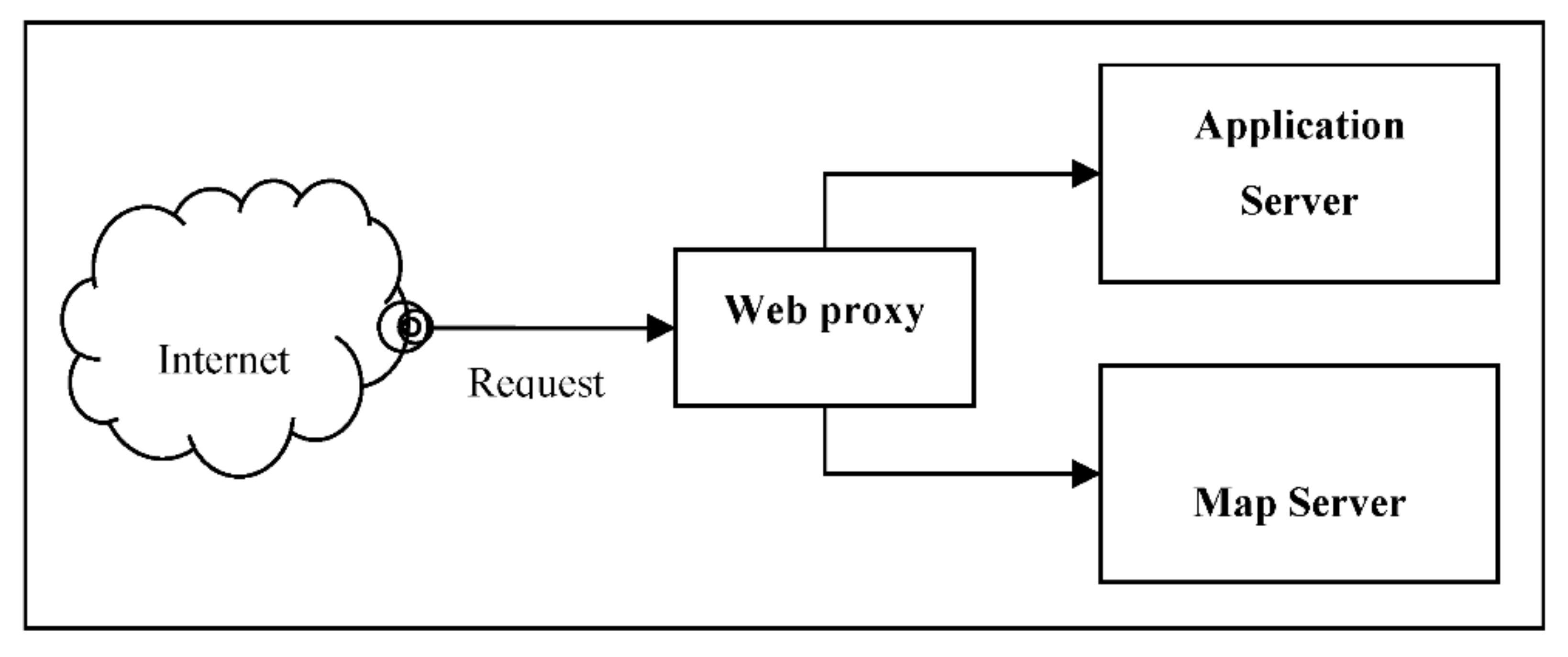
To speed up the process of displaying an archeological site’s polygonal areas on the digital interactive map, the architecture is divided into two major components, which are accessed through a proxy:
- the application server;
- the map server.
The application block diagram architecture (Figure 9) focuses on the web proxy, which plays an important role in routing each request to the application server and/or the map server.

Figure 9.
ArchTerr’s application block diagram architecture overview.
For hardware implementation, we chose a structure based on virtual machines, mainly to enable future-proof expansion. The hardware architecture (Figure 10) is based on a single fully redundant server (processor, storage, memory, power supply) and external shared storage to create snapshot backups for each virtual machine.
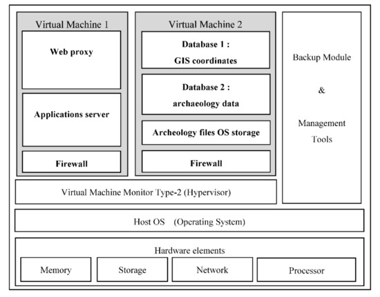
Figure 10.
System’s hardware architecture based on a fully redundant server.
The main reason for using this approach was to increase the services’ availability. This can be achieved due to the ability to easily perform a full backup and/or a full restore for each virtual machine in the case of malfunction.
A second benefit of using this approach is the possibility to migrate a complete virtual machine to a different hardware server if more storage space or more processing power are needed.
The following are installed on the hardware (comprised of processors, random access memory, storage, and networking interface access):
- a type 2 Virtual Machine Monitor (Hypervisor);
- the host operating system;
- the administration and management tools for the entire structure and the backup module;
- Virtual Machine 1;
- Virtual Machine 2.
For better security and to increase the web application protection against common web attacks, such as Brute Force attacks, Command Injections, XSS, and SQL Injections, each virtual machine is separated and protected by an individual firewall using a Linux-based kernel. A future development will be the insertion of a frontal Web Application Firewall engine such as NAXSI or Fortinet.
To better secure the meaningful data, only the virtual machine hosting the application is exposed to the Internet, rather than the databases stored on the second virtual machine.
The first virtual machine architecture is built around the intelligent server applications that enables ArchTerr’s functionalities:
- The web proxy server, which has the role to provide the user-friendly interface. The interface is used both as an entry point to acquire archaeological information and GIS data, and as an interactive display tool for polygons representing each protected area and archaeological site.
- The application server, which has the main roles to analyze the coordinates for each archeological site, perform the conversion between Stereo70 and WGS84 when needed, and display an archeological site position on the map. It calculates the overlapping terrain areas and, if necessary, displays error and warning messages.
- A security firewall.
The web proxy is implemented using NGINX. This web engine is “an HTTP and reverse proxy server, a mail proxy server, and a generic TCP/UDP proxy server” and we use it to expose only one virtual machine (the one hosting the web application) to the Internet. The web proxy function is used to route the traffic to both virtual machines according to specific rules.
From a conceptual perspective, each archeological site and its protected area is identified, represented, and stored in separate databases. The site coordinates are separated from the site attributes (archeological data) using different databases. The logical link between them is undertaken using a unique identifier.
The second virtual machine is created mainly for storage and is comprised of:
- the first database used to store the GIS coordinate data for each archeological site and its protected areas;
- a second database to store other relevant archeological information of any other type except coordinates;
- Storage of files associated with an archeological site, if necessary, in the operating system (file system hierarchy);
- A security firewall.
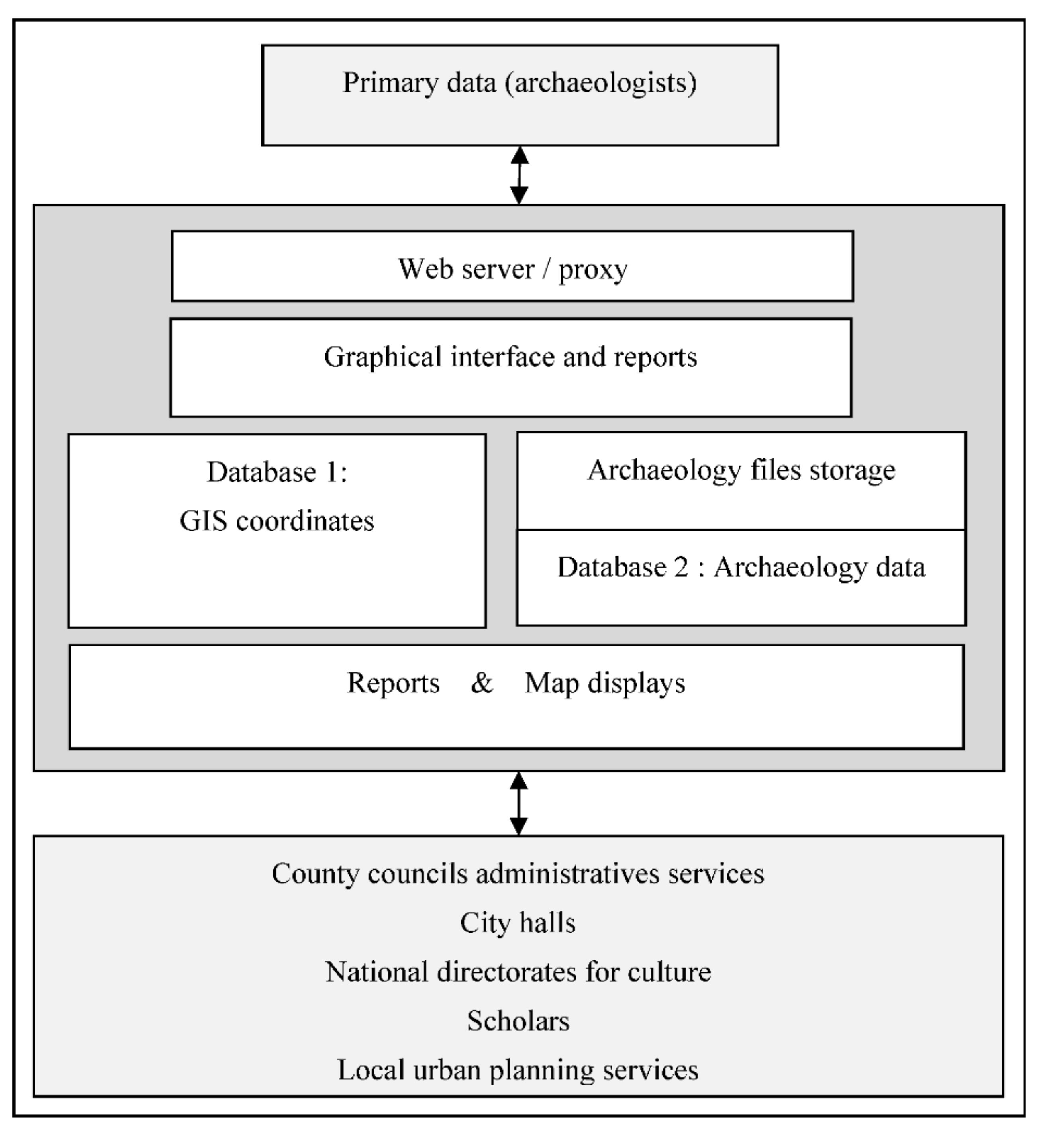
The functional software system’s architecture (Figure 11) is based on two databases for archeological data and GIS coordinates, the archeological files stored in the operating system’s file system, and the main component that has the logic to interconnect these modules, create the maps for display, and generate reports.

Figure 11.
Functional software system architecture.
The typical use cases for this application consist of:
- national-wide directorates for culture;
- local urban city planning services;
- administrative services in county councils;
- city halls’ authorization services;
- private users.
Archeologists are considered primary data providers and standard users comprise county council administrative services, city halls, national directorates for culture, scholars, local urban planning services, etc., as described in [3].
The functional interaction with the primary input data providers is managed through a web server that gives access not only to the graphical interface, but also to reports (Figure 11); a detailed software system architecture overview can also be found in [3].
The application server (Figure 12) hosts the interactive web application, the web proxy, and a security firewall. The application uses the Node.js Express back-end web application framework. It is connected to the Internet using a reverse proxy (implemented on NGINX).
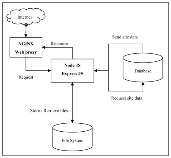
Figure 12.
The application server internal structure and functional interactions.
Globally, similar implementations use paid solutions. In the current project, we used only open source software and technologies to develop the ArchTerr web application. The online web application is based on NodeJS stack and uses a PostgreSQL database. The responsive web application was designed to implement a robust REST API.
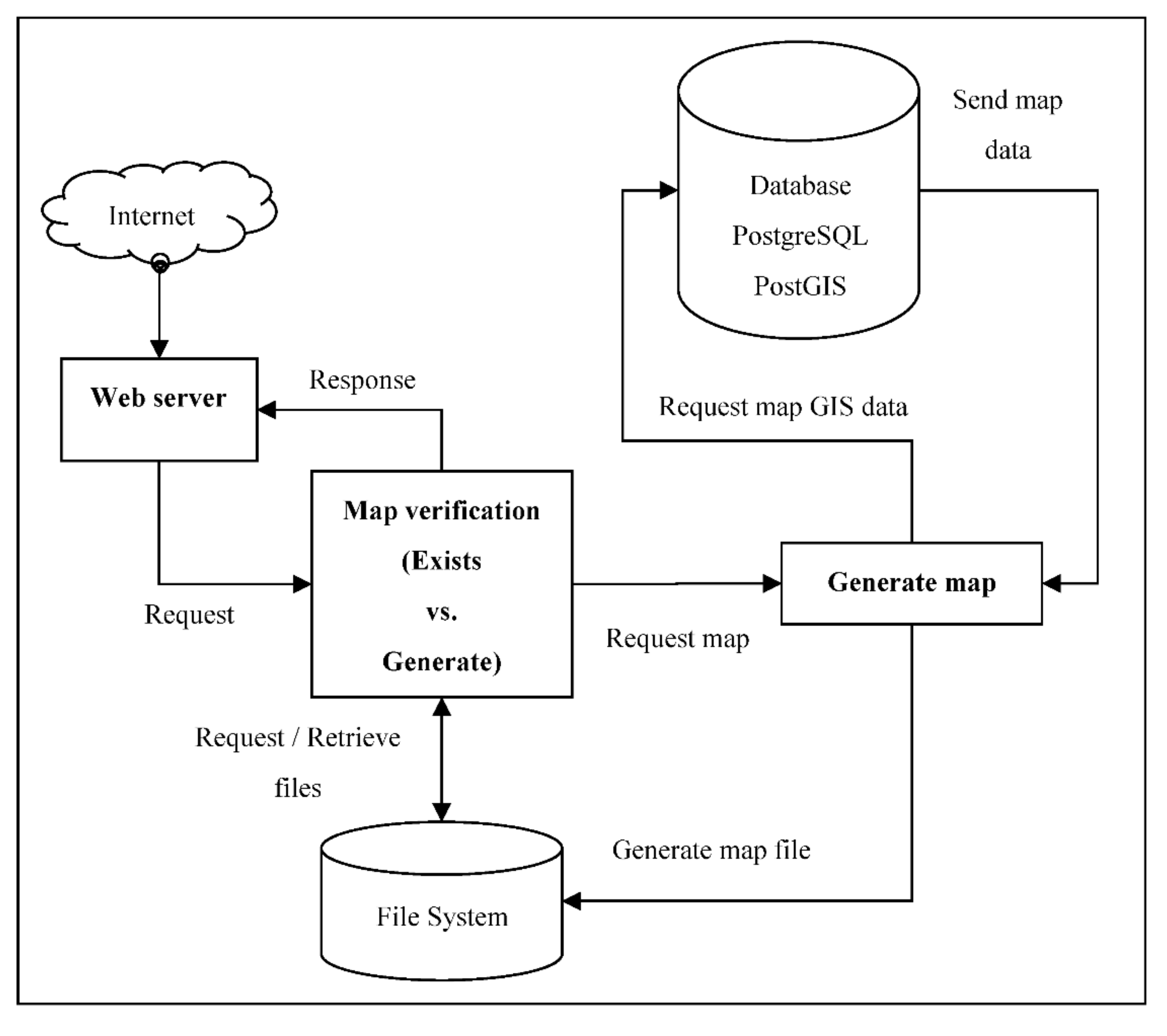
The process of map generation/retrieval is handled by the map server (Figure 13). This involves not only the module that calculates the necessary map (tile), but also a mechanism to save processing power and optimize hardware resources.

Figure 13.
The map server internal structure and functional interactions.
The map server (Figure 13) receives requests from end users. After each request for a new map, the server calculates this map (tile) and then saves it in the file system for another request. If the map exists, it is served directly from the file system.
5. Main Functionalities (Tested and Validated)
The ArchTerr scientific research project has multiple outcomes, of which several are referenced here. The functionalities described below are based on the interactive digital map interacting with two databases, for archeological data and for GIS-based coordinates. A more detailed presentation can be found in [1].
1. Real-time bidirectional translation and, on the map, simultaneous representation of the data of different coordinate systems. This approach has the benefit of avoiding both human-error prone intervention and the use of intermediate transformations (using external conversion tools). The end user can select the geographical coordinates system (Figure 14), and the software application automatically translates the latitude/longitudinal coordinates in the X/Y system. The conversion of the internal coordinates between Stereo70 and WGS84 geospatial systems is performed prior to map representation.
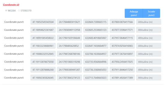
Figure 14.
WGS84 and Stereo70 coordinates converted for each archeological site area corner.
2. The verification of the correctness of the WGS84 or Stereo70 coordinates translated in real time and the archeological site position seen as a polygon on the digital map.
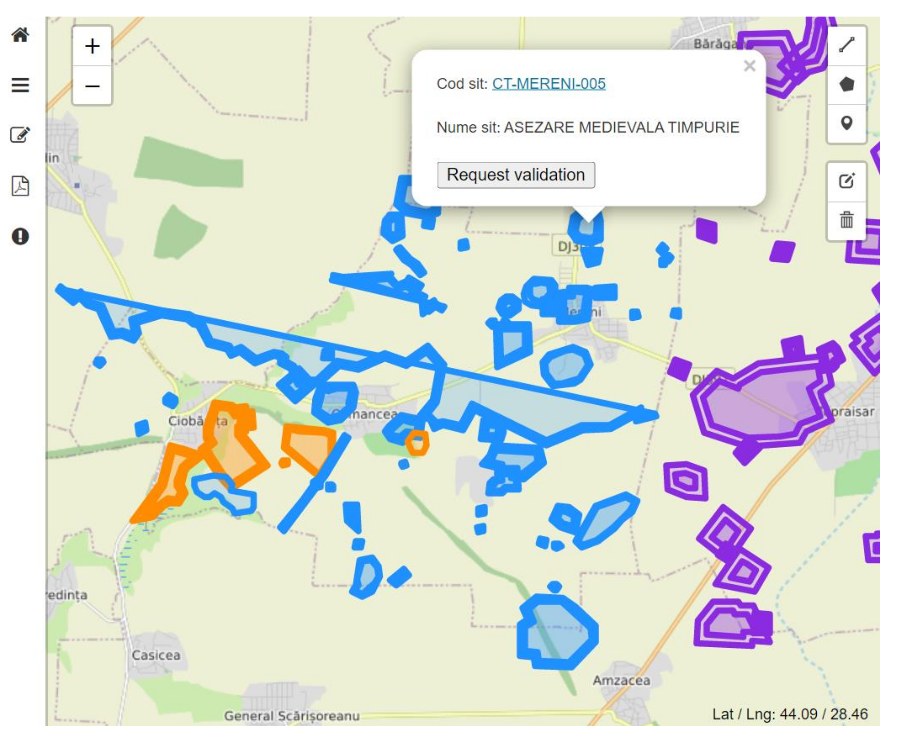
3. Inside an archeological site, multiple areas (such as site, protection area, and research area) can be marked differently, using polygons representing archeologically restricted access limits (Figure 15).
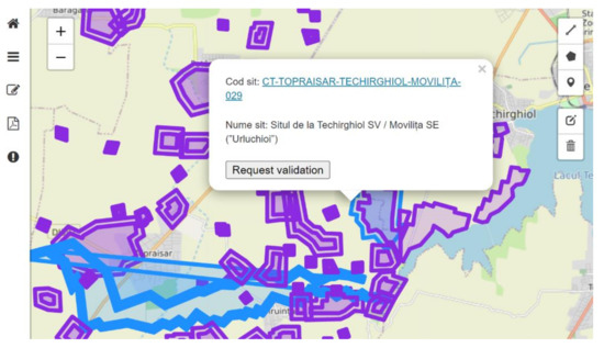
Figure 15.
Archeological site protected areas sent for validation (blue) and already validated (purple).
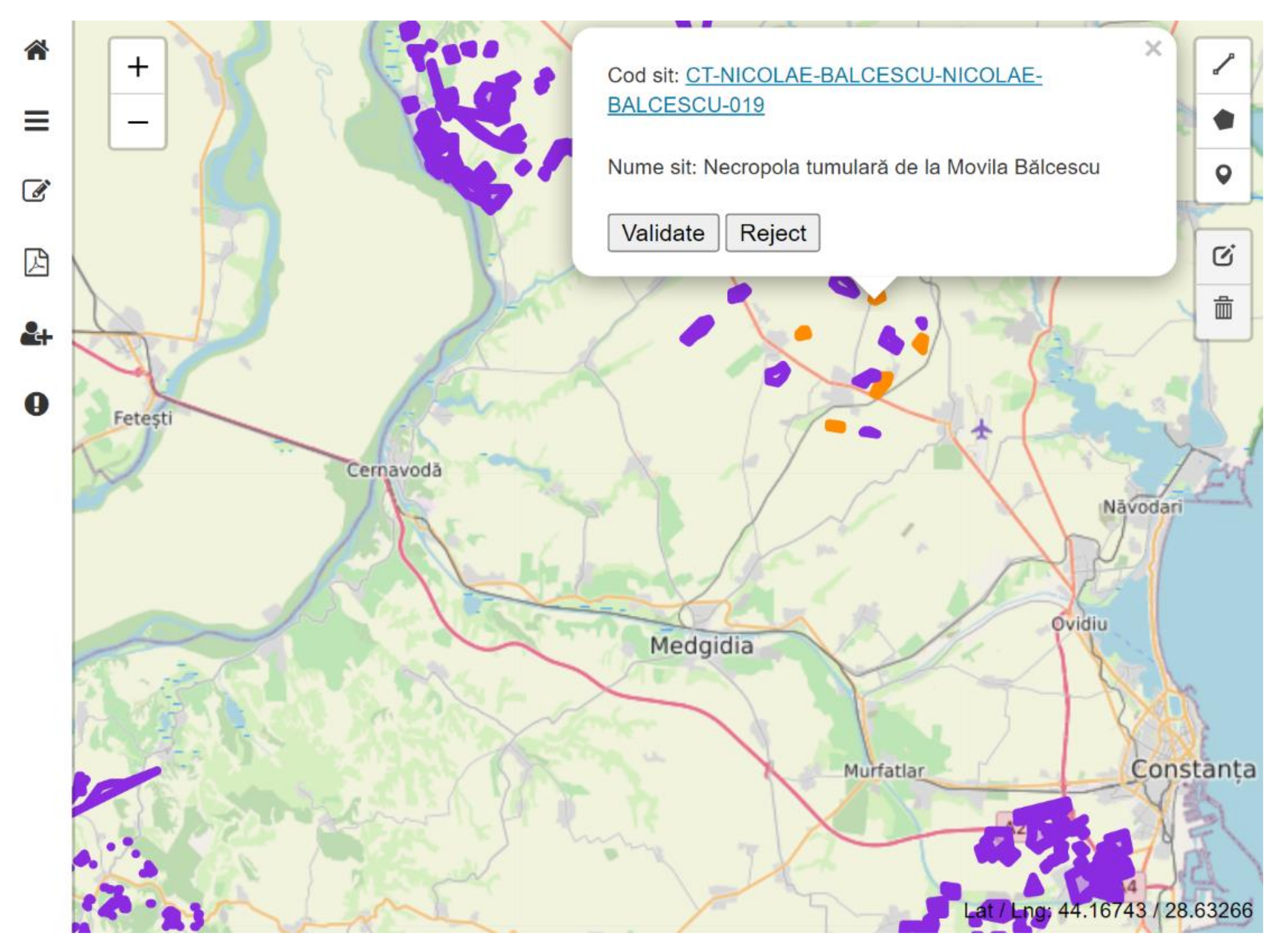
The manager/supervisor can easily assess the status of each site because they are colored differently based on their validation status (Figure 16). Archeological sites are represented as follows: the sites before requesting validation (are represented using blue color), the sites who are under review and pending decision for validation (are represented using orange color), the validated and publicly accessible sites (are represented using purple color).

Figure 16.
Archeological sites before requesting validation (blue), sites pending decision for validation (orange), and validated and publicly accessible sites (purple).
4. Each user has different visual representations of the same GIS data and archeological information. This feature is implemented based on a user’s permission matrix. The manager/supervisor has a different view (the possibility to validate or reject a site) compared to a regular archeologist, who just enters data (Figure 17).

Figure 17.
Archeological sites during the validation process (orange) viewed by the application manager and validated sites (purple).
5. Each user, based on his permission level, can undertake an instantaneous visual comparison of overlapping areas (the archeological site and protected area vs. the terrain under investigation for a future investment) (Figure 18). The application detects the overlapping areas and issues a warning.
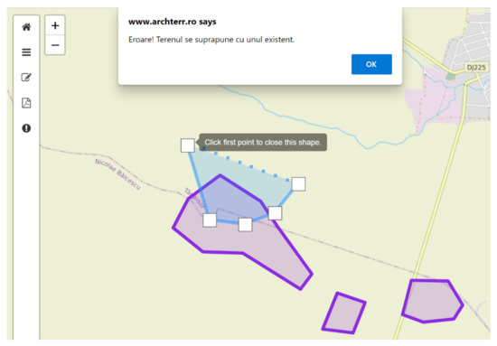
Figure 18.
System warning issued in the case of a comparison of overlapping areas with validated archeological sites (purple).
6. Any user access can easily access any archeological site information (for investments or city planning services) to facilitate information transparency.
7. The user-friendly interface simultaneously provides geospatial information and overlapping site-related information, such as descriptive text and identification.
8. To better support the archeologists and regular users, the application generates pdf-format documents containing context-based information relevant to the user’s access level.
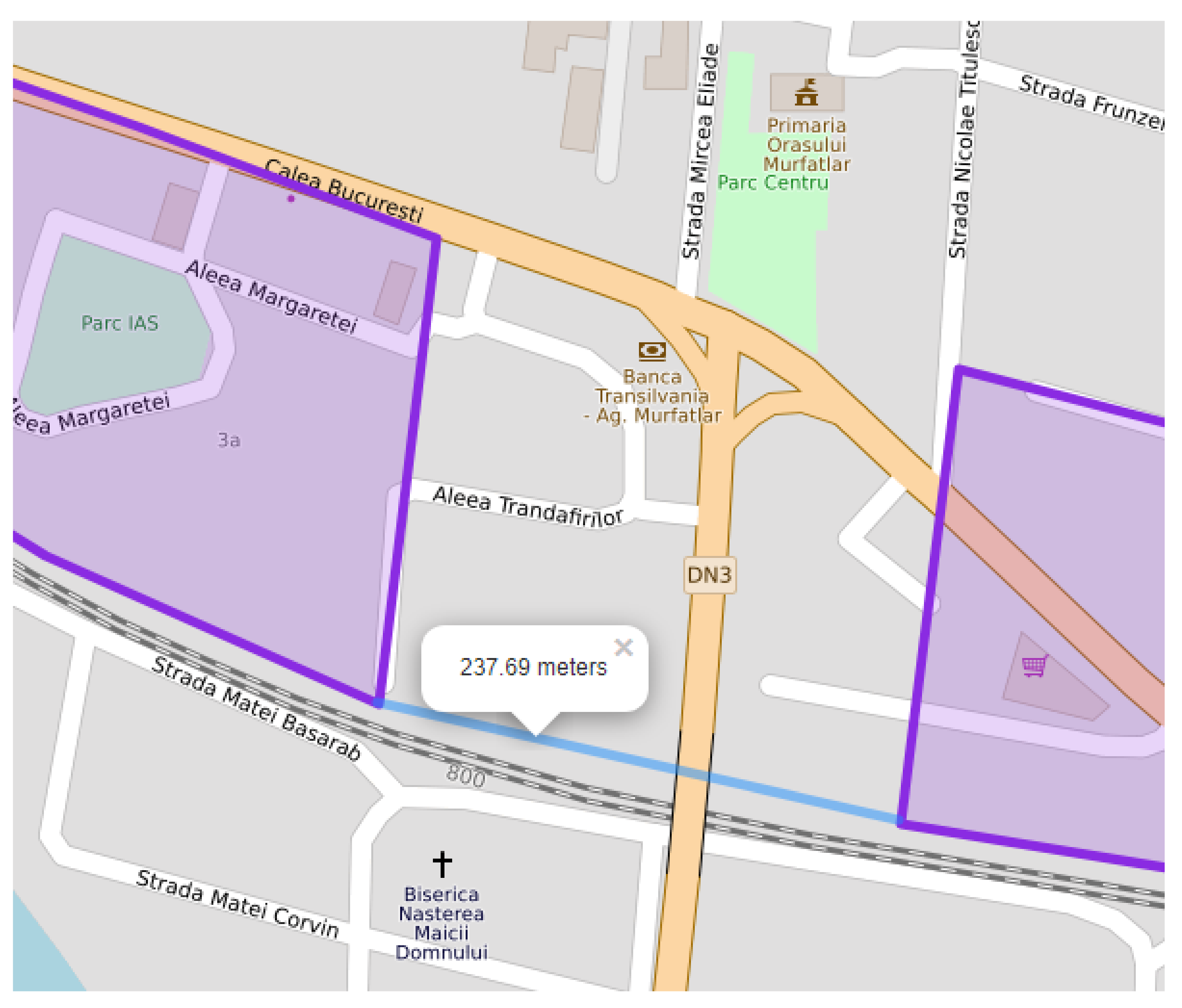
9. The web application enables instantaneous measurement of any distance on the map (Figure 19). The distance measurement can be performed on any shape, straight line, or broken line.
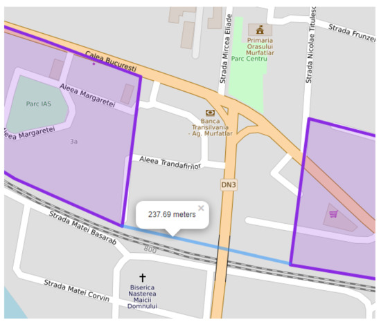
Figure 19.
Distance measurement between any map points. In this case between two validated archeological sites (purple).
10. ArchTerr’s interactive digital map product is implemented on a fully redundant cluster architecture in order to be used as a daily working tool by officials of the Ministry of Culture territorial branch offices, private investors, cadastral offices and real estate advertising agencies, city halls, etc.
From a technical point of view, the most important achievements during the project design and implementation were:
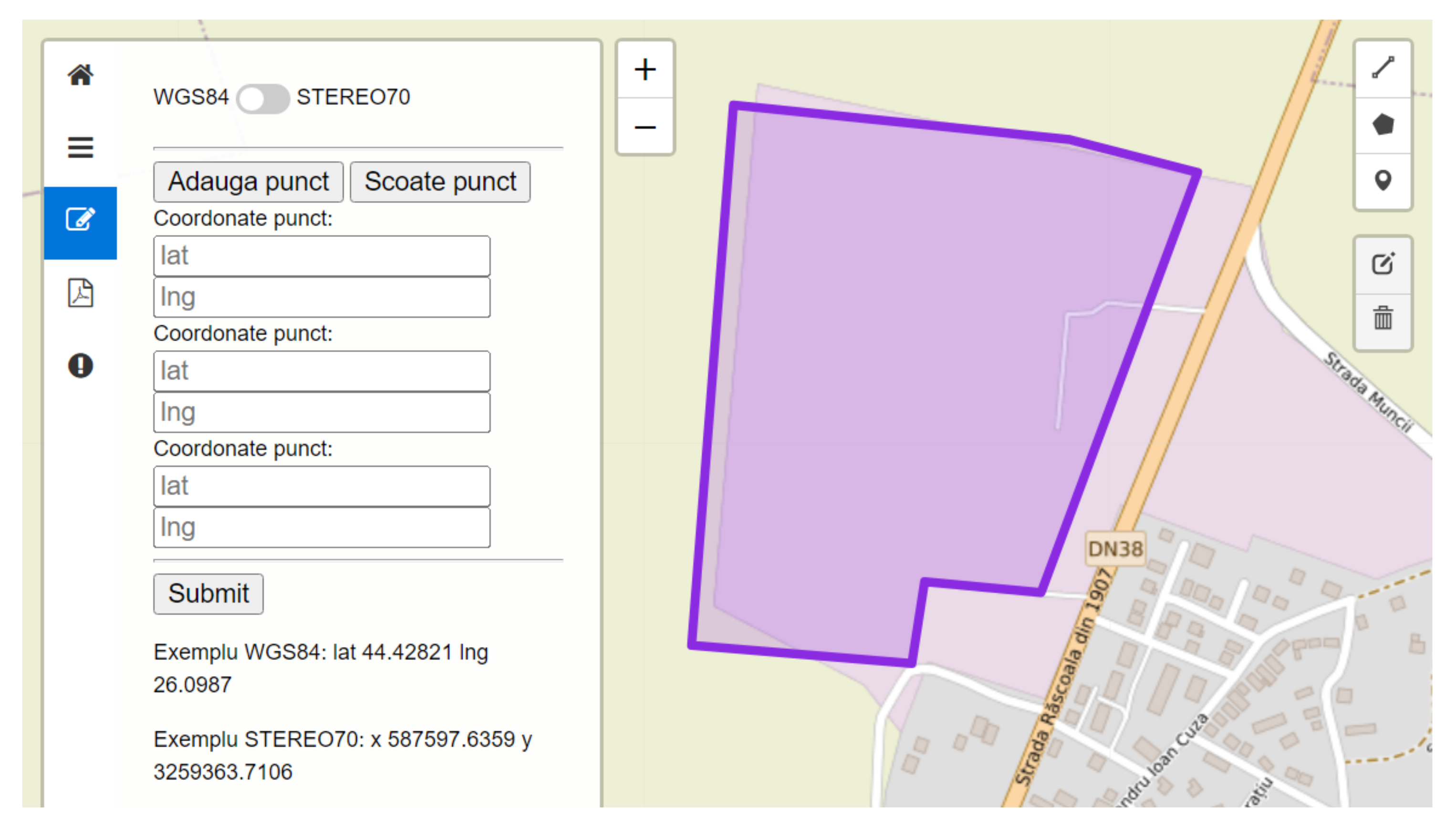
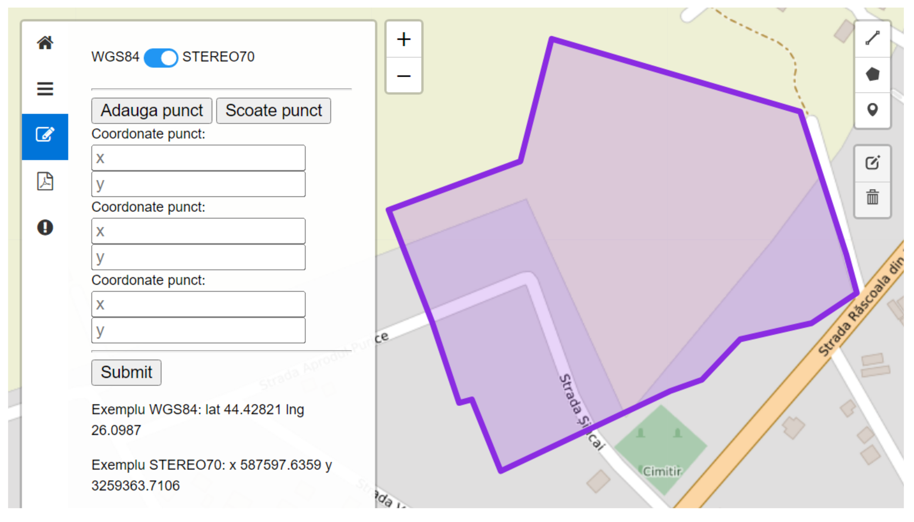
1. Using a pure mathematical translation, it was necessary to be able to instantaneously convert the WGS84-based coordinates into the Stereo70 system coordinates format and vice versa.
Usually, these transformations are available only in expensive commercial products. We used only open source applications; thus, human intervention or calculations are no longer required, and it is not necessary to use other proprietary software applications.
The user graphical interface allows coordinates to be entered in the WGS84 system (Figure 20) or Stereo70 system (Figure 21). To ensure the user does not enter data in the wrong format, examples are provided for each coordinate format.
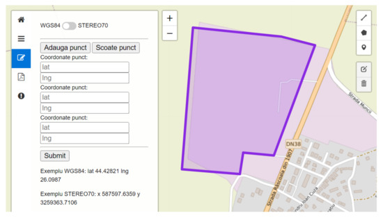
Figure 20.
User graphical interface to input coordinates in WGS84 format and map representation. The validated archeological site represented in purple color.
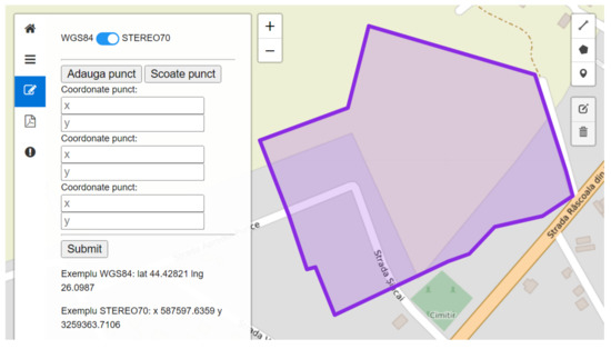
Figure 21.
User graphical interface to input coordinates in Stereo70 format and map representation. The validated archeological site represented in purple color.
2. Due to their work specificity, archeologists may be required to access the computer application from remote sites having poor data coverage, although most private users use good-quality fixed or mobile Internet connections. Thus, we designed the computer application in such manner to minimize the necessary amount of data to be sent and received between the users’ terminal equipment and central servers.
The central servers host the application, the graphical user interface, and the databases. The terminal equipment used by archaeologists in the field or by regular users includes tablets, GPS devices, smartphones, and performance laptops.
3. The access devices used by archeologists and private users differ not only in terms of resolution and screen size, but also in terms of software applications used to collect the GIS data and to access the project graphical user interface.
This diversity had to be addressed by the technical team to maintain the same user satisfaction level and compatibility of wide-area devices.
6. Discussion and Results
During the development of the entire project, the IT application using an interactive digital map was initially tested in three counties, which was later extended to seven counties, involving the branches of the Ministry of Culture in the respective counties.
In the first year of the project, the application was developed based on the specialists’ team requirements. In the subsequent 9 months, the 14 specialists (archaeologists) entered descriptive and geospatial information for approximately 1000 archaeological sites into the database of the computer application. These archaeological sites were analyzed by the supervisor and approximately 750 were validated and are accessible to the general public.
The information entered in the database came from the following sources:
- administrative documents (historical–archaeological studies to substantiate the general urban plans of some counties, cities, municipalities);
- systematic or preventive research reports published in the Chronicle of Archaeological Research in Romania [20];
- original preventive archaeological research reports;
- scientific materials (archaeological directories, archaeological monographs, specialized studies published in specialized journals);
- the documentation related to the List of Historical Monuments [53] in the archaeological sites section;
- the documentation related to the National Archaeological Repertory [47].
The unitary means of presenting and organizing the information, its quality and accuracy, the implemented functionalities, and the user-friendly access to any information through the search criteria, have attracted the attention of numerous users, professionals and non-professionals, who have accessed the application website in the last 6 months.
In Constanța county, for which the branch of the Ministry of Culture introduced the largest number of sites into the system, a major benefit was a reduction in the time taken to respond to public requests regarding the presence or absence of archaeological heritage elements in certain terrain areas.
The previously presented functionalities, and especially the friendly, intuitive means of working with and entering data in the platform, enabled other public institutions in the same category (branches in the territory of the Ministry of Culture in counties other than those initially involved in the project) to formulate requests to use this system.
Once as much information as possible is entered into the system, considering the completely open means of access, the urban planning services in each city or county will be able to directly consult on the position of a piece of land in relation to an archaeological site and its protection zone.
In this manner, prompt, accurate answers can be offered to the applicants, immediately from the information phase and the request for the urban planning certificate. At the same time, the public services in each city or county can promptly and efficiently fulfill their duties in the field of archaeological heritage protection, having at their disposal a platform with stored and thematically structured specialized information.
The cadaster and real estate advertising offices can retrieve data and information stored in the system to create databases of the specialized cadaster of archaeological sites and historical monuments. A possible further development will be the interconnection of the ArchTerr system with the database of the National Agency for Cadastre and Real Estate Advertising (Imobile eTerra) [54].
Since the information is unrestricted, any general public user who is interested in finding out about certain aspects related to the archaeological heritage can do so publicly, free of charge, and without the need to obtain any credentials in advance. Both administrative and scientific information regarding an archaeological site (or a set of sites, e.g., the spatial distribution of a certain type of archaeological site) can be obtained.
For example, an investor can determine, from the moment he intends to purchase a piece of land or make an investment on a certain land area, its status from the perspective of protecting the archaeological heritage. Using our application, the information can be obtained in a preliminary manner and without consuming time or financial resources. The investor is informed ab initio whether there are additional costs related to that land, depending on its location in relation to an archaeological site or protection zone (e.g., expenses related to preventive archaeological research for freeing the land of archaeological duties). In this way, the investor can make a financial assessment and a time projection for the development of the investment at the start of the project.
Finally, the record of the archaeological heritage managed by the IT application considerably reduces the number of interventions that can result in the destruction of archaeological sites. The data are updated as soon as new official information related to archaeological discoveries is brought to the attention of the institution that manages the protection of cultural heritage. In addition, the specialized documentation of areas having archaeological heritage is a means of saving the archaeological heritage, even for land areas for which the archaeological burden is removed.
7. Conclusions
The computer system developed within the ArchTerr project (publicly available, free of charge, at www.archterr.ro) represents the outcome of the scientific research project and, in many ways, provides a benchmark in terms of applying the concept of protecting the archaeological heritage using modern Information Technology-based tools.
The project was financed as a result of its selection in a competition among approx. 80 projects having the same subject area and dedicated to research and national cultural heritage protection.
The ArchTerr project’s software application achieved the integration and unification at the national level of information about the archaeological heritage of some territorial administrative units (counties), which was previously distributed among several entities (museums, universities, city halls, Ministry of Culture territorial branches, etc.). This led to both refined and accurate data, and a unitary approach to the archaeological national heritage. The digital storage of paper archives and the computerization of archeological data allowed a major optimization of the response time when providing information to citizens. The fact that the platform instantaneously integrates, and performs the conversion between, several geospatial systems (a GIS-based modern system and the official standardized system), allows any citizen to confirm the position of a land area, regardless of the system in which they acquire the geospatial data.
Although integrated into the general trend of development of archaeological heritage management systems (refer to the achievements related to this topic in countries with a tradition of protecting cultural heritage, such as England, France, Italy, and Greece), the ArchTerr software platform excels in directly addressing a wider range of users for whom it has created opportunities for direct interaction. This functionality reduces waiting times at both the public institutional level and for private beneficiaries. Furthermore, the latter have the possibility of planning not only the timeframe of the investment, but also its financial development, depending on the location of the intervention area in relation to an archeological site or its protection area. The presented system is the first national platform in Romania to record archaeological heritage, having a unitary design and being accurately and constantly updated via the uploading of data into the system (by specialists who have the best knowledge of the cultural heritage of a county/administrative territorial unit and employees of the county directorates for culture).
The created system can be further developed, outside the scope of this project, by adding a module that provides integration with systems managing natural environment protected areas, because it is mandatory that environmental protection issues are addressed together with those of protected archaeological heritage.
Author Contributions
Conceptualization, C.V.M. and M.I.; methodology, M.I.; software, C.V.M.; validation, M.I.; writing—original draft preparation, C.V.M. and M.I.; writing—review and editing, C.V.M. and M.I.; supervision, C.V.M. All authors have read and agreed to the published version of the manuscript.
Funding
This work was supported by a grant of the Romanian Ministry of Education and Research, CCCDI-UEFISCDI, project number PN-III-P2.2.1-PED-2019-5037 contract number PED 571/2020 within PNCDI III.
Institutional Review Board Statement
Not applicable.
Informed Consent Statement
Not applicable.
Data Availability Statement
Not applicable.
Acknowledgments
This research project was designed and developed by two teams forming a Research Excellence Cluster in “Dunarea de Jos” University Galati (Department of History) and “Politehnica” University of Bucharest (Department of Engineering in Foreign Languages, Faculty of Engineering in Foreign Languages).
Conflicts of Interest
The authors declare no conflict of interest.
References
- Marian, C.V.; Iacob, M.; Goga, N. The Interactive Digital Map—A Modern Approach for Archaeological Heritage Management. JAHA 2001, 8, 215–228. [Google Scholar] [CrossRef]
- Marian, C.V.; Iacob, M. Digital Map (GIS based) for Archeological Heritage. AES 2021, 2, 1–3. [Google Scholar] [CrossRef]
- Marian, C.V.; Iacob, M.; Mitrea, D.A. GIS-Based integrated system with Interactive Digital Map for archaeological heritage protection. In Proceedings of the ECAI 2022, Ploiesti, Romania, 30 June 2022; ISBN 978-1-6654-9535-6. [Google Scholar] [CrossRef]
- Strategia Naţională de Apărare a Ţării pentru perioada 2015–2019. O Românie puternică în Europa şi în lume. (Defense National Strategy for 2015–2019 Time Period. A Strong Romania in Europe and in the World). Available online: https://www.presidency.ro/files/userfiles/Strategia_Nationala_de_Aparare_a_Tarii_1.pdf (accessed on 30 June 2022).
- The Venice Charter (1964–2004). Available online: https://www.icomos.org/venicecharter2004/ (accessed on 30 June 2022).
- European Convention on the Protection of the Archaeological Heritage. Available online: https://rm.coe.int/1680072318 (accessed on 30 June 2022).
- Charter for the Protection and Management of the Archaeological Heritage (1990). Available online: https://www.icomos.org/charters/arch_e.pdf (accessed on 30 June 2022).
- Convention for the Protection of the Archaeological Heritage of Europe (Revised) (Valletta, 1992). Available online: https://www.coe.int/en/web/culture-and-heritage/valletta-convention (accessed on 30 June 2022).
- Convention on the Value of Cultural Heritage for Society (Faro Convention, 2005). Available online: https://www.coe.int/en/web/culture-and-heritage/faro-convention (accessed on 30 June 2022).
- Wienberg, J. The Perishable Past—On the Advantage and Disadvantage of Archaeology for Life. Curr. Swed. Archaeol. 2021, 7, 183–202. [Google Scholar] [CrossRef]
- Demoule, J.P. (Ed.) L´Archéologie Préventive Dans le Monde: Apports de l´Archéologie Préventive à la Connaissance du Passé; La Découverte: Paris, France, 2007. [Google Scholar]
- Dans, E.P. Heritage in danger. The collapse of commercial archaeology in Spain. Archaeol. Dialogues 2019, 26, 111–122. [Google Scholar] [CrossRef]
- Matero, F.G. Heritage, conservation, and archaeology: An introduction. AIA 2008, 1–5. Available online: https://www.archaeological.org/pdfs/Matero.pdf (accessed on 30 May 2022).
- Borș, C. Protejarea Patrimoniului Arheologic din România. Despre Situri și Monumente Arheologice din Perspectiva Evoluției Cadrului Legislativ în Context European; Mega: Cluj-Napoca, Romania, 2014; pp. 90–92. [Google Scholar]
- Schlanger, N. Preventive Archaeology. In The Oxford Companion to Archaeology, 2nd ed.; Silberman, N.A., Bauer, A., Holtorf, C., Diaz-Andreu, M., Waterton, E., Eds.; Oxford University Press: Oxford, UK; New York, NY, USA,, 2012; Volume 2, pp. 661–665. [Google Scholar]
- Bozóki-Ernyey, K. (Ed.) European Preventive Archaeology; Papers of the EPAC Meeting, Vilnius; National Office of Cultural Heritage: Budapest, Hungary; Council of Europe: Strasbourg, France, 2004. [Google Scholar]
- Demoule, J.P. Archeologie preventive, recherche scientifique et concurrence commerciale. In Le Nouveau Droit de L‘archeologie Preventive; Frier, P.-L., Ed.; L’Harmattan: Paris, France; Budapest, Hungary; Torino, Italy, 2004; pp. 203–246. [Google Scholar]
- Guermandi, A.P.; Salas Rossenbach, K. Twenty Years after Malta: Preventive Archaeology in Europe and in Italy; IBC: Bologna, Italy, 2013; Available online: http://online.ibc.regione.emilia-romagna.it/h3/3.exe/apubblicazioni/t?ISBN=9788897281146 (accessed on 2 July 2022).
- Novaković, P.; Horňák, M.; Guermandi, M.P.; Stäuble, H.; Depaepe, P.; Demoule, J.-P. (Eds.) Recent Developments in Preventive Archaeology in Europe, Proceedings of the 22nd EAA Meeting, Vilnius, Lithuania, 31 August–4 September 2016; Ljubljana University Press: Ljubljana, Slovenia, 2016. [Google Scholar]
- Cronica Cercetărilor Arheologice din România, 1983–2021. Rapoarte Preliminare de Cercetare Arheologică. Available online: http://cronica.cimec.ro/ (accessed on 13 July 2022).
- Cowley, D.C. (Ed.) Remote Sensing for Archaeological Heritage Management, Proceedings of the 11th EAC Heritage Management Symposium, Reykjavík, Iceland, 25–27 March 2011; EAC Occasional Paper No. 5; Europae Archaeologiae Consilium: Brussels, Belgium, 2011. [Google Scholar]
- Castillo Mena, A. Archaeological Heritage Management in the World Heritage: A Preventive Archaeology Proposal. In The Significance of World Heritage: Origins, Management, Consequences. The Future of the World Heritage Convention in a Nordic Perspective; Jansson, B.G., Ed.; Dalarna University: Dalarna, Sweden, 2013; pp. 179–194. [Google Scholar]
- Darvill, T. Archaeological resource management. In The Concise Oxford Dictionary of Archaeology, 2nd ed.; Oxford University Press: Oxford, UK, 2009; Available online: https://doi.org/10.1093/acref/9780199534043.001.0001 (accessed on 13 July 2022). [CrossRef]
- García-Sánchez, I.-M.; Rodríguez-Ariza, L.; Frías-Aceituno, J.-V. The cultural system and integrated reporting. Int. Bus. Rev. 2013, 22, 828–838. [Google Scholar] [CrossRef]
- Kajda, K.; Marx, A.; Wright, H.; Richards, J.; Marciniak, A.; Rossenbach, K.; Frase, I. Archaeology, Heritage, and Social Value: Public Perspectives on European Archaeology. Eur. J. Archaeol. 2018, 21, 96–117. [Google Scholar] [CrossRef]
- Barreiro, D.; Pousa, R.V.; Dans, E.P. Malta beyond Malta: The confluence between preventive and public archaeology as a new horizon/Malta más allá de Malta: La confluencia entre arqueología preventiva y arqueología pública como un nuevo horizonte. CPAG 2018, 28, 149–173. [Google Scholar]
- Rossi, A.; Santoriello, A. Dal document storico all‘inteligenza artificiale: Il contributo dell‘archeologia aerea all‘analisi preventive. A. Aerea 2009, IV, 169–176. [Google Scholar]
- Heritage and Technology. Mind Knowledge Experience, Proceedings of the La Vei dei Mercanti—XIII Forum Internazionale di Studi, Aversa, Italy, 11–13 June 2015; Gambardella, C. (Ed.) La Scuola di Pitagora: Napoli, Italy, 2015. [Google Scholar]
- Boschi, F. (Ed.) Looking to the Future, Caring for the Past Preventive Archaeology in Theory and Practice. Bononia University Press: Bologna, Italy, 2016. [Google Scholar]
- Horňák, M.; Zachar, J. Some Examples of Good Practice in LiDAR Prospection in Preventive Archaeology. Interdiscip. Archaeol. Nat. Sci. Archaeol. 2017, VIII, 113–124. [Google Scholar] [CrossRef]
- Heritage Gateway. Available online: https://www.heritagegateway.org.uk/gateway/ (accessed on 2 July 2022).
- Canmore. National Record of the Historic Environment. Available online: https://canmore.org.uk/ (accessed on 2 July 2022).
- Coflein. The Online Catalogue of Archaeology. Available online: https://coflein.gov.uk/en/ (accessed on 2 July 2022).
- La Carte Archeologique Nationale. Available online: https://www.culture.gouv.fr/Thematiques/Archeologie/L-archeologie-en-France/La-conservation-et-la-mise-en-valeur-du-patrimoine-archeologique/La-Carte-archeologique-nationale (accessed on 2 July 2022).
- Atlas des Patrimoines. Available online: http://atlas.patrimoines.culture.fr/atlas/trunk/ (accessed on 2 July 2022).
- Regione Emilia-Romagna—Patrimonio Culturale: C.A.R.T. Available online: https://patrimonioculturale.regione.emilia-romagna.it/aree-tematiche/comunita/incontrare-il-patrimonio/cartella-privata/progetti-1/c.a.r.t (accessed on 2 July 2022).
- Pocobelli, G.F. Anghiari. La Carta del Rischio Archeologico. Stato della ricerca, problemi e prospettive. In Le Memorie Celate: Il Paesaggio Archeologico Nella Terra di Anghiari; Salvini, M., Lelli, P., Eds.; Palazzo della Battaglia: Anghiari, Italy, 2009; pp. 16–21. [Google Scholar]
- CART. Carta Archeologica del Rischio Territoriale (IBC. Informazioni, Commenti, Inchieste sui Beni Culturali 1998, 6, 3); Guermandi, M.P., Ed.; Istituto per I beni artistici, culturali e natuurali della Regione Emilia Romagna: Bologna, Italy, 1998. [Google Scholar]
- Guermandi, M.P. (Ed.) Rischio Archeologico: Se lo Conocí lo Eviti. Atti del Convegno di Studi su Cartografia Archeologica e Tutela del Patrimonio (Ferrara 2000); All’Insegna del Giglio: Firenze, Italy, 2001. [Google Scholar]
- Il Sistema Informativo Territoriale Archeologico di Roma (SITAR). Available online: https://www.archeositarproject.it/en/ (accessed on 2 July 2022).
- Serlorenzi, M.; De Tommasi, A.; Grassucci, R.; Vismara, A. Il webGIS del SITAR: Riflessioni, approcci e percorsi metodologici per la pubblicazione e la multi-rappresentazione dei dati territoriali archeologici. Proceedings of the ARCHEOFOSS. Free, Libre and Open Source Software e Open Format nei Processi di Ricerca Archeologica, Atti del VII Workshop, Rome, Italy, 11–13 June 2012; Serlorenzi, M., Ed.; Archeologia e Calcolatori: Rome, Italy, 2013; Supplement 4. [Google Scholar]
- National Archive of Monuments—Archaeological Cadastre. Available online: https://www.arxaiologikoktimatologio.gov.gr/en (accessed on 2 July 2022).
- Mapa web de la Consejeria de Cultura y Patrimonio Historico. Available online: www.juntadeandalucia.es/cultura (accessed on 2 July 2022).
- ARQUEOS. The Information System of the Andalusian Archaeological Heritage; Fernández Cacho, S., Ed.; Editorial Comares: Granada, Spain, 2002. [Google Scholar]
- Saraç, D. History of Archaeological and Cultural Heritage Management in Turkey and Europe: A Look from the Past to the Present. Master’s Thesis, Bilkent University, Ankara, Turkey, 2003. [Google Scholar]
- Bogdani, J. Archeologia e Tecnologie di Rete. Metodi, Strumenti e Risorse Digitali; BraDypUS Editore: Rome, Italy, 2019. [Google Scholar]
- Repertoriul Arheologic Național. Available online: http://ran.cimec.ro/ (accessed on 2 July 2022).
- EGISPat. Available online: https://patrimoniu.ro/monumente-istorice/egispat (accessed on 2 July 2022).
- Mihai, D.; Angelescu, M.V. A centrally managed GIS System for the Protection of the Archaeological Sites and Historic Monuments. In Listing Archaeological Sites, Protection for Historical Landscape; EAC Occasional Paper nr. 3; EAC: Brussels, Belgium, 2009; pp. 109–114. [Google Scholar]
- Oberländer-Târnoveanu, I. Patrimoniul arheologic național: Politici, documentare, acces. In Arheologia și Politicile de Protejare a Patrimoniului Cultural în România (Culegere de Studii); Musteață, S., Ed.; Arc: Chișinău-Iași, Moldova, 2014; pp. 13–43. [Google Scholar]
- Fișa de Sit. Available online: https://view.officeapps.live.com/op/view.aspx?src=http%3A%2F%2Fran.cimec.ro%2Fdownload%2FFisaDeSit.doc&wdOrigin=BROWSELIN (accessed on 23 May 2022).
- OMC nr. 2.682 din 13 Iunie 2003 Privind Aprobarea Normelor Metodologice de Clasare şi Evidenta a Monumentelor Istorice, a Listei Monumentelor Istorice, a Fisei Analitice de Evidenta a Monumentelor Istorice şi a Fisei Minimale de Evidenta a Monumentelor Istorice). Available online: https://legislatie.just.ro/Public/DetaliiDocumentAfis/44602 (accessed on 23 May 2022).
- Lista Monumentelor Istorice. Available online: https://patrimoniu.ro/monumente-istorice/lista-monumentelor-istorice (accessed on 2 July 2022).
- Geoportal ANCPI. Available online: http://geoportal.ancpi.ro/geoportal/imobile/Harta.html (accessed on 23 May 2022).


Publisher’s Note: MDPI stays neutral with regard to jurisdictional claims in published maps and institutional affiliations. |
© 2022 by the authors. Licensee MDPI, Basel, Switzerland. This article is an open access article distributed under the terms and conditions of the Creative Commons Attribution (CC BY) license (https://creativecommons.org/licenses/by/4.0/).