Article

Investigating Urban Underground Space Suitability Evaluation Using Fuzzy C-Mean Clustering Algorithm—A Case Study of Huancui District, Weihai City

1
Faculty of Engineering, China University of Geosciences, Beijing 100083, China
2
No. 6 Geological Brigade, Shandong Bureau of Geology and Mineral Resources Exploration and Development, Weihai 264200, China
*
Author to whom correspondence should be addressed.
Appl. Sci. 2022, 12(23), 12113; https://doi.org/10.3390/app122312113
Submission received: 27 October 2022 / Revised: 16 November 2022 / Accepted: 24 November 2022 / Published: 26 November 2022

Abstract

:
The development of underground space resources can alleviate the problems of traffic congestion and land resource tension caused by urbanization, but there are also certain risks in the development of underground space, so the suitability of development needs to be evaluated. This paper takes the geological suitability of underground space resources in Weihai City as the evaluation object, establishes the index system for evaluating the geological suitability of underground space resources development and utilization, determines the criteria for quantifying each factor index, uses the hierarchical analysis method to determine the index weights and applies the fuzzy C-mean clustering algorithm to evaluate the geological suitability of underground space resources development and utilization in the urban area of Weihai City, and achieves excellent results that are more in line with the geological conditions.

1. Introduction

With the development of society and the acceleration of urbanization, there are many problems in cities, such as dense buildings, traffic congestion, and crowded living space, so the need for underground urban development is becoming more and more urgent. The development and utilization of urban underground space in foreign countries are early, and the achievements are high in developed countries such as Japan, the United States, and Europe [1]. In recent years, with the deepening of reform and opening up and the rapid development of economic and social development, China’s urban construction is in a period of rapid development, and the 21st century is also the heyday of China’s urban transportation construction. Therefore, a more scientific, rational, and efficient approach has been identified as the development direction for the development and utilization of underground space resources in China [2,3,4].
For the evaluation of underground space suitability, many scholars have evaluated underground space resources in different cities. To assess the impact of underground space development on urban compactness, Hong Yuan [5] chose a comprehensive compactness formula to determine the influencing factors based on the examples of Futian Station in Shenzhen and Tokyo Station and investigated the interaction mechanism between underground space utilization and urban compactness development. Jian Peng [6] selected several candidates for influencing factors on two underground lines in Osaka, Japan, and investigated the quantitative relationship between the influencing factors and the distribution of urban underground space around underground stations. Jiaqi Wang [7] investigated the geological and urban planning conditions in Tangshan City and, based on this, proposed the concept of underground space development and selected the storage and utilization of underground space waste according to local conditions. De Rienzo F [8] presented a three-dimensional geological and geotechnical model of the subsoil of Turin City. The model is managed through a geographic information system (GIS) and provides a more intuitive and scientific basis for planning and managing the underground space resources of Turin and subsequent decisions on construction plans. De Rienzo F [9] established a systematic evaluation index system for the first time in the planning of underground space in Singapore, taking into account geological, hydrological, and environmental conditions, as well as social, political, economic, and other factors.
There are currently many evaluation methods for urban underground space development, and the more mature ones applied are the fuzzy mathematical method [10], hierarchical analysis (AHP) [11], the expert scoring method [12], rough set theory and conditional entropy [13] and the grey assessment method [14], or a combination or improvement of two or more of these methods before using them [15,16,17,18,19,20]. In this paper, it is not practical to use an accurate deterministic model to find the weights of evaluation factors because there are many influencing factors involved in the development and use of underground space resources, and each evaluation factor has different attributes, metrics, qualitative and quantitative criteria, and the complexity and multi-level nature of the evaluation factors. Based on the above analysis, this paper adopts the combination of the expert scoring method and hierarchical analysis method, using the expert scoring method to determine the evaluation factors, writing a fuzzy C-mean clustering algorithm through python, processing the data, and finally importing it into GIS for visualization to realize the suitability evaluation of the study area.
As a key development city in Shandong Province, Weihai City has seen a rapid expansion of its urban area along with rapid development, and the city’s living space environment has become increasingly harsh, with conflicts such as traffic congestion, lack of energy and water pollution, to solve many of these problems. The road to sustainable urban development inevitably requires large-scale urban underground space development and utilization. In the development and utilization of urban underground space, full use should be made of local geological conditions, effectively avoiding and transforming unfavorable conditions so that underground buildings can be both safe and economically valuable [21]. At present, the investigation of the potential of underground space resources in Weihai City has not yet been reported, and it is of some practical significance to research this topic.

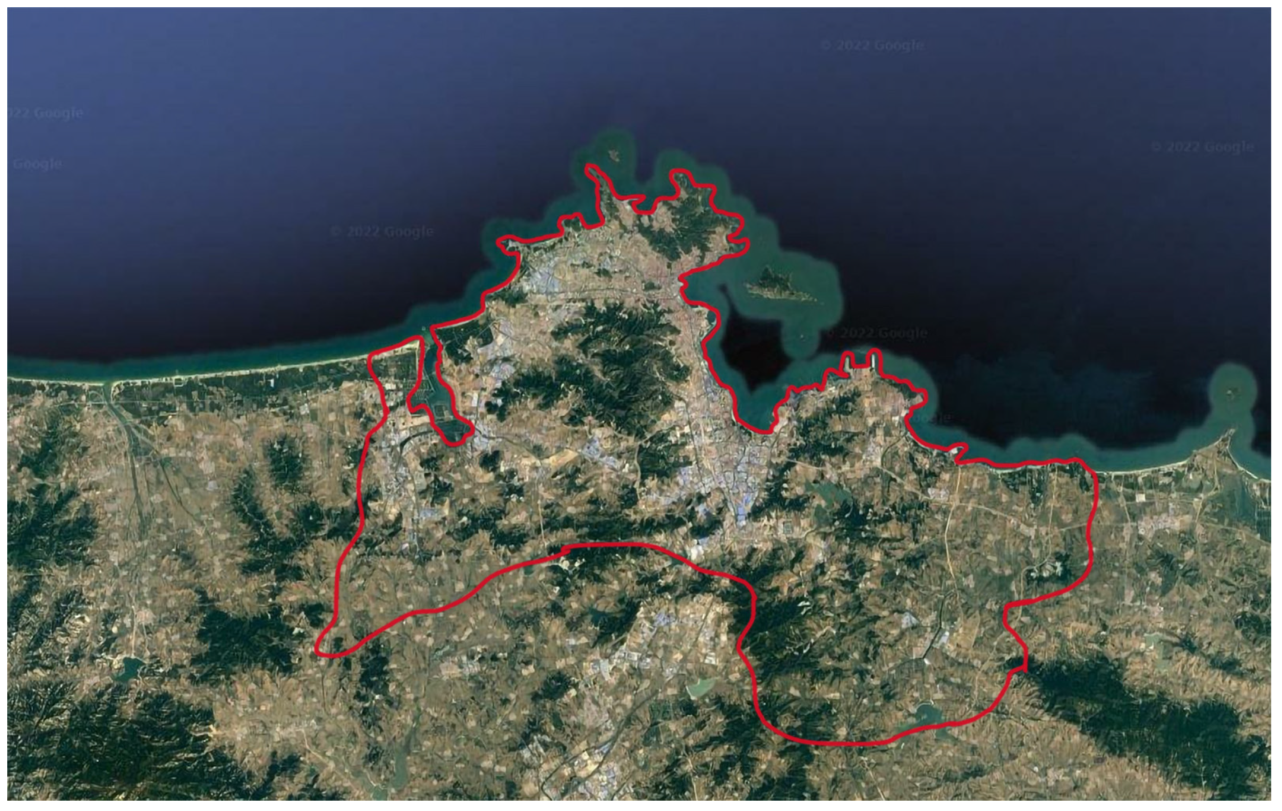
2. Description of the Study Area

Weihai City is one of the first open coastal cities in China with great potential for development. The working area is the Huancui District of Weihai City, which is the political, economic and cultural center of Weihai City. It is located at the easternmost tip of the Shandong Peninsula, surrounded by the sea in the north, east and south, bordering Yantai City in the west, opposite to the Korean Peninsula and Japanese islands in the east, and looking across the sea from the Liaodong Peninsula in the north, as shown in Figure 1. The geological environment is the carrier of underground space development and utilization, and the advantages and disadvantages of geological environment conditions are the key factors in determining the safety and economy of underground engineering [22]. Huancui District belongs to the coastal low-hill area, with an average altitude of 70–100 m. The overall topography is high in the central and southeastern parts and low in the western and northwestern parts, with low hills and plains distributed between each other. The geotectonic unit is located in the Jiaodong-Weihai uplift area of the North China plate and is part of the Sulu collisional orogenic belt of the central orogenic region. The brittle fracture structure is more developed in the west and east of the district, while the central part is poor. In the Huancui district, along the valleys between the mountains, there is a multi-layered structure of clayey soils on top and sandy soils on the bottom. In the area of Shuangdao Bay, the upper part of the clayey soil is mostly silt-like soil, which is a weak engineering geological layer, and the lower part of it is powdered clay and clay, while the rest of the clayey soil is mostly powdered clay and clay. The rivers in the Huancui District of Weihai City belong to the peninsula’s marginal water system and are rain-fed rivers in the monsoon area. The runoff is affected by seasonal differences, and the flow is often broken during the dry season. The rivers are all seasonal rivers with short sources and rapid flows. During the flood season, heavy rainfall becomes a disaster and the riverbeds are severely scoured, after which the rivers dry up, and the riverbeds are exposed. In addition, according to the groundwater geological environment monitoring data of Weihai City for many years, there are elements such as NO3, NH4+, SO42−, F, Mn, Zn, Pb and Cl in the groundwater in the area that exceeds the groundwater quality category III standard.

3. Study Methods and Evaluation Process

There are currently many methods for evaluating urban underground space resources; the more mature ones include hierarchical analysis, fuzzy comprehensive evaluation method, expert scoring method and grey assessment method, etc., or the two mentioned methods are combined with each other or improved to use. The fuzzy C-mean clustering algorithm used in this paper has not yet been popularized in the field of underground space resources development and utilization and is a relatively new method, which is the main innovation of this paper. This paper adopts the hierarchical analysis method to construct an evaluation model for the suitability of underground space development and utilization, determines the weights of each influencing factor, establishes an evaluation index system, uses the fuzzy C-mean clustering algorithm, and adopts the weighted Euclidean distance to determine the distance or similarity between samples and clustering centers.
In the process of evaluating the suitability of the geological environment for the development and use of underground space resources in Weihai City, we first carried out the analysis of the influence and control factors for the development and use of underground space resources, established the evaluation index system, and used the AHP method and the fuzzy C-mean clustering algorithm to finally obtain the evaluation results and distribution characteristics of the suitability of the geological environment for the development and use of underground space resources in Weihai City. The overall technical route of the evaluation is shown in Figure 2.

3.1. Selection and Quantification of Indicators

3.1.1. Levels of Evaluation

According to the actual utilization of underground space resources in Weihai, the existing engineering technology level, and different utilization depths, the underground space resources in Weihai are divided vertically into three levels, including shallow depth (0–30 m underground), medium depth (30–100 m underground) and deep depth (100–200 m underground), which are evaluated in layers when carrying out the work.

3.1.2. Evaluation Indicator System

This paper uses the hierarchical analysis method to construct an index system for evaluating the suitability of urban underground space resources for development and use. To evaluate the suitability of urban underground space resource development using the AHP method, it is necessary to first hierarchize and classify the problem. The problem is decomposed into different constituent elements, and afterward, according to the association and affiliation between the elements, different levels of clustering are combined to construct a multi-level hierarchical model, where the factors of the upper level play a dominant role over the elements of the lower level by a certain criterion, and these levels can usually be divided into three categories:
Target level (A): represents the objective of the assessment decision and usually has only one element.
Guideline level (B): is the intermediate level involved in achieving the objective level and consists of 1 or more levels, also known as the intermediate or indicator level.
The bottom layer (C): consists of several evaluation elements that affect the objectives, also known as the measure layer, program layer, etc., and is a key part of building an evaluation system.
In this evaluation work, the evaluation of the suitability of underground space resources development in the evaluation area is taken as the target layer (A), and the hydrogeological conditions (B1), engineering geological conditions (B2), environmental geological conditions (B3), and human engineering activities (B4) are taken as the secondary indicator layers; the bottom layer selects the main factors affecting each condition of the secondary indicator layers.
In this paper, 11 factors, including minimum depth of groundwater, groundwater richness, groundwater quality, topography and geomorphology, distance from fracture structure, lithological combination, avalanche, and slip flow, mining collapse, seawater intrusion, ground space feature type, and developed underground engineering, are selected as influencing factors. The index system for evaluating the suitability of underground space resource development in Weihai City is shown in Figure 3.

3.1.3. Quantitative Grading of Evaluation Indicators

According to the regional engineering construction experience, the distribution characteristics of hydrogeological conditions, geological engineering conditions, environmental geological conditions, and human engineering activities in the area and their influence on the development of underground space resources are comprehensively analyzed, and the suitability of the geological environment for the development of underground space resources is divided into four excellent evaluation grades (Grade I), good (Grade II), medium (Grade III) and poor (Grade IV). According to the degree of influence of different categories of GeoEnvironmental factors on the geological environment of underground space resource development, grading criteria are established, as shown in Table 1.

3.2. Weighting of Evaluation Indicators

This paper determines the weights of evaluation indicators by using hierarchical analysis, which differs from a direct assignment in that it analyses a complex decision-making problem to determine the objectives of the problem study, the factors affecting the problem, and the relationships between the factors. The influencing factors are then formed into a hierarchy, i.e., the indicators within each level are independent of each other, and the different levels are graded according to their relevance to higher-level indicators. In the evaluation of underground space resource development, the final hierarchy generally includes a target layer, a criterion layer, and an alternative layer. The target layer is the quality of underground space development resources development, the criterion layer is generally selected according to the main factors affecting the development of underground engineering in the evaluation area, and the alternative layer is graded according to the types of elements in the criterion layer. In general, the hierarchical analysis method consists of six main calculation steps: clarifying the problem, establishing a hierarchical analysis structure, constructing a judgment matrix, consistency testing, single ranking of the hierarchy and total ranking of the hierarchy, and finding the combined weight value of each element of the hierarchy to the total target by calculating the weight value within each hierarchy separately.
By analyzing the factors influencing the development and utilization of underground space in the study area and using the hierarchical analysis 1–9 scale method to indicate the strength of influence between factors, a 2-by-2 comparison is made item by item regarding the relative importance of the factors in each level to the target of the previous level, and a discriminant matrix is constructed. The maximum eigenroots, the corresponding eigenvectors, the single ranking of each layer, and the judgment matrix consistency test are then calculated.
The specific principles are as follows.
1. To clarify the problem when analyzing a decision problem, the objective of the research problem must first be clarified. For this paper, the objective of the quality evaluation of underground space resource development must first be determined, i.e., to determine the suitability of underground space resource development according to geological conditions;
2. Establishing a hierarchical analysis structure selecting evaluation indicators that can represent the evaluation area according to the geological characteristics of the evaluation area, grouping the factors in the system into one category according to the same characteristics, and then forming a higher level (criterion level) hierarchy according to the commonality between factors of the same category, until the highest level is formed to establish a hierarchical structure of the evaluation system;
3. After the hierarchical structure is established, a judgment matrix is constructed by comparing the importance of the two indicators within each level to each other. If the previous level element Bk is used as a criterion for the next level element C1, C2, …, Cn has a dominant relationship, for these n elements, a two-by-two judgment matrix A = (aij)n × n is obtained, where aij indicates the importance values of factor Ci and factor Cj relative to the target Bk. It is clear that the judgment matrix A is a positive and negative matrix with the following properties:
(1)
aij > 0
(2)
aij = 1/aij(i ≠ j)
(3)
aii = 1(i, j = 1, 2, 3, …, n)
For the positive and negative matrix A, if for any i, j, k there is aij − ajk = aik, then the judgment matrix A is said to be consistent. In the hierarchical analysis method, the importance level is often expressed according to the numerical value, and the importance level between two indicators is scored according to the experts’ experience and theoretical knowledge for quantification, and then the importance level is formed into a judgment matrix. The following Table 2 shows a commonly used 1–9 scale method.
4. Consistency check of the judgment matrix To ensure that the importance scores between the indicators are reasonable, the consistency of the constructed judgment matrix needs to be checked. Assume that the characteristic roots of the discriminant matrix A are λ1, λ2, …, λn; if satisfied by Ax = λx, there will be
i = 1 n λ i = n
When matrix A has perfect consistency, the largest eigenroot is λmax = n, and the rest of the eigenroots are zero; When matrix A is not perfectly consistent, then we have λmax > n. The remaining characteristic roots λ1, λ2, …, λn are related as follows:
i = 2 n λ i = n λ max
From the above conclusions, it is clear that when the judgment matrix is not guaranteed to have complete consistency, the corresponding characteristic roots of the judgment matrix will change so that the changes in the characteristic roots of the judgment matrix can be used to check the degree of consistency of the judgment. Therefore, the negative average of the remaining characteristic roots of the judgment matrix other than the largest characteristic root is introduced in the hierarchical analysis method as a measure of the deviation of the judgment matrix from consistency, i.e., the consistency of the decision maker’s judgment thinking is checked by the following formula; the larger the CI value, the greater the deviation of the judgment matrix from full consistency; the smaller the CI value, the closer to zero, the better the consistency of the judgment matrix;
C I = λ ma x n n 1
5. With the discriminant matrix constructed by the single hierarchical ranking, the maximum eigenroots and the corresponding maximum eigenvectors of the discriminant matrix can be approximated by the square root method. The maximum eigenvector is the weight of the importance of each indicator within a given hierarchy;
6. The total hierarchical ranking is based on the established hierarchy, and the weight values of each bottom level are calculated in turn, moving up the hierarchy in turn until the relative importance values of the total objectives are calculated. The results of the calculation of the hierarchical ranking are then checked for consistency from the top to the bottom of the hierarchy to ensure that the discriminant matrix is reasonable.

3.3. Fuzzy C-Means Clustering Algorithm

3.3.1. Specific Principles

In recent years, relying on the improvement of computer processing power, machine learning-related algorithms have been strongly developed in various disciplines, such as image recognition, language processing, engineering computing, document classification, and so on. Machine learning [23] is an important method for artificial intelligence research, and many scholars have researched new intelligent algorithms [24] or improved them based on existing algorithms with many results. Machine learning is broadly divided into supervised learning and unsupervised learning, and supervised learning requires a large number of samples for training to get the ideal model, and because the evaluation of underground space resources development is a complex evaluation system involving too many evaluation factors, the computational model is generally multidimensional or even a dozen dimensions, and because the geological conditions in different regions are often different, it is difficult to find training samples for supervised learning, so this paper chooses the unsupervised learning method. The unsupervised learning methods include deep learning [25], neural networks [26], Simulated annealing [27], and fuzzy algorithms [28]. According to the characteristics of the evaluation of subterranean space development involving qualitative and quantitative indicators—the data are fuzzy, and the evaluation results are hierarchical suitability classifications, fuzzy algorithms are most widely used in many fields such as pattern classification, image processing, and fuzzy rule processing, etc., compared to the applicable characteristics of other unsupervised learning methods, so this paper is more suitable for the calculation of fuzzy clustering algorithm analysis. The common fuzzy algorithms are the mean fuzzy algorithm and Gaussian fuzzy algorithm [29], among which the fuzzy C-mean clustering algorithm [30], as an improvement of the traditional fuzzy algorithm, takes the affiliation degree as any number in the interval [0 1], and the proposed basic basis is the criterion of “minimizing the sum of squared intra-class weighted errors.” The fuzzy C-mean is an improvement of the K-mean method. The objective function of the algorithm is the same as the K-mean, but the difference is that the fuzzy weight index is added to the objective function, which can be better applied in the underground space assessment work. The fuzzy C-mean clustering algorithm has been used in geotechnical engineering in many applications: slope stability analysis [31], arable land and agricultural land suitability evaluation, etc., but it has not been applied in the direction of underground space resource development evaluation, so the fuzzy C-mean clustering method is used to evaluate the underground space resource development as the innovation point of this paper. In this paper, the paradigm in the objective function of fuzzy C-mean clustering is used as weighted Euclidean distance to improve the commonly used Euclidean distance, and the value of each index is calculated by the hierarchical analysis method. That is, the weighted Euclidean distance is used to determine the distance or similarity between the sample and the clustering center. By finding the distance between the sample points and the best clustering center, the difference between the attribute values of the best clustering center points and the attribute values in the sample is minimized. The objective function is established as follows:
J = i = 1 C j = 1 n u ij m x j c i 2
Xj is the sample point, ci is the ith clustering center, and m is the weighting index. Usually, m = 2, and Uij is the fuzzy similarity matrix. The constraints are as follows:
i = 1 c U ij = 1
The classification problem is, therefore, mathematically modeled by converting the optimal classification problem into a problem of finding the extreme value of min(J) subject to constraints. By expanding the constraints via the Lagrangian and combining the two equations above, it is possible to find the extreme value when there exists:
c i = j = 1 n ( x j u ij m ) j = 1 n u ij m
U ij = 1 k = 1 c ( x j c i x j c k ) ( 2 m 1 )
Therefore, it can be seen that the value of the cluster center Ci is directly related to the fuzzy similarity matrix Uij, i.e., determining the cluster center Ci determines Uij, and determining Uij determines the cluster center Ci. Therefore, given an initial cluster center Ci or matrix Uij, the minimum extreme value of the objective function J(x) can be found by iteration. The specific weighted Euclidean distance expression is as follows:
x j c i = k = 1 n ω k · ( x jk c ik ) 2

3.3.2. Method of Implementation

In this paper, the fuzzy C-mean clustering algorithm is written based on Python, and the main iterative steps are as follows.
  • Determine the number of classifications, the dimensionality, the value of the fuzzy index m, and the number of iterations;
  • Initialize an affiliation matrix U that satisfies normalization and sums to 1;
  • Calculate the clustering center C based on the initialized U;
  • update the affiliation U using a weighted Euclidean distance based on the value of C;
  • Repeat steps 3 and 4 until the number of iterations is reached;
  • Determine the classification result based on the maximum affiliation;
  • Consider the clustering complete when the clustering centers of the samples no longer change.

3.3.3. Establishing a Fuzzy C-Mean Clustering Model

Although thousands of calculation tools are available in GIS, this paper uses fuzzy C means clustering and improved weighted Euclidean distance, and raster analysis cannot be performed directly in GIS. It is complicated to build a toolbox by toolbox, so this study uses a simple method of exporting raster point data and calculating it in Python. Assuming that there are K evaluation indicators in the underground space resource development evaluation system U, and each indicator level raster map has N identical rasters, the K × N matrix of the extracted point data attributes is as follows.
U = U 1 , 1 U 1 , 2 U 1 , K U 2 , 1 U 2 , 2 U 2 , K U N , 1 U N , 2 U N , K
An improved fuzzy C clustering algorithm was written by Python, and since the numbers in Python start from 0, if we assume that the rubric set is divided by four levels and each raster classification result is Vi, then Vi can only be 0, 1, 2, 3. The raster map of all evaluation indexes is rasterized to points, and then the data is matched with the spatial location of the raster according to the point number, and the data is imported into the Python model for calculation, and the calculated results are imported into the form of point data, matched with the point number, and finally, the raster map of suitability levels is generated based on the MAX principle in the point-to-raster, which ensures that the generated raster map is identical to the original raster Finally, the raster map is generated based on the MAX principle in point-to-raster, ensuring that the generated raster map is identical to the center point and raster position of the original raster.
In the Raster point element process, a point is created in the output element class for each image element of the input raster dataset. These points will be positioned at the center of the image element they represent. No data image element will not be converted to a point, and the field parameters can be selected as input raster dataset attribute fields that can become attributes of the output element class. The point element number is the same for all evaluation metric raster maps, and when converting points to raster, the value of the point within each raster image is usually assigned to the corresponding raster image, and the No Data value is assigned to raster images that do not contain points. If multiple points are found in a raster image, the value of the first point encountered is assigned to that raster image. To ensure the accuracy of the element point to raster conversion, the size of the original raster element is captured during the conversion, and the element with the most common attribute in the value field is assigned to the element according to MOST_FREQUENT in cell_assignment, i.e., if there are multiple elements in the element. Only the raster centroid elements are in the raster, so the accuracy of the transformed raster is guaranteed.

4. Case Study

According to the collected data, the evaluation levels were divided, the evaluation index system was established, and the evaluation indexes were quantified and graded. The hierarchical analysis method was applied to obtain the index weights, and the fuzzy C-mean clustering algorithm was used to complete the classification, and the classification results were input into GIS for visualization according to the centroid data derived from the raster to obtain the final zoning map for the evaluation of underground space resources development. The thresholds of the comprehensive scoring results were all divided into four levels, namely: excellent zone (Ⅰ), good zone (Ⅱ), medium zone (Ⅲ), and poor zone (Ⅳ) for the suitability of underground space development and utilization. The final zoning map for the evaluation of the geological suitability of underground space resources development and utilization in the urban area of Weihai City was obtained (Figure 4, Figure 5 and Figure 6) as the area of suitability zoning (Table 3).
According to the comprehensive suitability evaluation map and the evaluation distribution table, we can know that
(1) Combined with the 0–30 m, 30–100 m, and 100–200 m strata, the overall suitability of underground space utilization in Huancui District of Weihai City is good, with the sum of the area of Zone I and Zone II accounting for 79%, 94%, and 100% respectively.
(2) In the 0–30 m strata, the areas of poor suitability are mainly located in Shuangdao Bay, Zhengqi Mountain, Funding, Nangli, Soapbu, the international seawater bathing beach, the coastal protection zone, the scenic tourist spot and the area around the shopping mall. The area of Shuangdao Bay is artificially filled, prone to uneven ground settlement, and is an unstable foundation for buildings; the area around Zhengqi Mountain and Funding has a large undulating terrain, making it difficult and expensive to develop underground space, and historical quarry pits can be seen everywhere, with geological hazards of collapse and landslides developing; Zhanli is prone to ground collapse; the International Beach is a tourist geological resource in the area and should be moderately protected; and the scenic tourist area, the is a key geological resource protection zone. Therefore, the development and use of underground space are not recommended in the above-mentioned areas.
(3) The space between 30–100 m and 100–200 m is unexploited, and because it is located in the bedrock distribution area, it can be regarded as a suitable area for underground space development and exploitation.

5. Discussion

Although this paper has achieved certain results in the study of the evaluation model of underground space resources development, the study is influenced by many factors because the development of underground engineering resources consists of multiple indicators, and the evaluation system is huge. And the data collected on the geology and hydrological conditions of the case area have limitations, and the research content can be further explored in depth.
(1) In the evaluation index system, the selection of indicators can be explored more carefully for different underground space resource situations, while the classification of index levels is somewhat subjective, and other methods can be used to make more accurate judgments on the classification levels to ensure more scientific and accurate evaluation results.
(2) As some of the indicators in the case areas are the same, the differences in the indicators are not reflected in the fuzzy C-mean clustering evaluation, thus ignoring the role of some indicators and making the evaluation results somewhat inaccurate. In the future, more representative areas can be selected for the evaluation of underground space resource development so that the results of fuzzy C-mean clustering can be more accurate.

6. Conclusions

(1) By reviewing the information on Weihai City, the factors affecting the suitability of underground space development and utilization were determined, and the weights were determined using the hierarchical analysis method, while the fuzzy C-mean clustering algorithm was used to evaluate the model, and more reliable results were obtained.
(2) There are many types of factors affecting the development of underground space in Weihai City, such as groundwater richness, fracture structure, lithological combination, minimum burial depth of groundwater, etc. Among them, the main factors affecting the suitability of underground space resources development and utilization in Weihai City are avalanche slide flow, fracture structure, and mining collapse. The process of underground space development and construction will also have an impact on the environment, such as groundwater pollution and lowering of the water table, which requires countermeasures during specific construction.

Author Contributions

M.W.: methodology, writing—original draft preparation, writing—reviewing and editing. H.W.: conceptualization, writing—reviewing and editing. Y.F.: methodology. Y.H.: methodology. Z.H.: conceptualization. B.Z.: supervision. All authors have read and agreed to the published version of the manuscript.

Funding

This research received no external funding.

Institutional Review Board Statement

Not applicable.

Informed Consent Statement

Not applicable.

Data Availability Statement

Some or all of the data, models or code supporting the results of this study are available from the corresponding author on reasonable request.

Conflicts of Interest

The authors declare no conflict of interest.

References

  1. Qian, Q.-H. Present state, problems and development trends of urban underground space in China. Tunn. Undergr. Space Technol. 2016, 55, 280–289. [Google Scholar]
  2. Peng, F.-L.; Qiao, Y.-K.; Sabri, S.; Atazadeh, B.; Rajabifard, A. A collaborative approach for urban underground space development toward sustainable development goals: Critical dimensions and future directions. Front. Struct. Civ. Eng. 2021, 15, 20–45. [Google Scholar] [CrossRef]
  3. Zaini, F.; Hussin, K.; Raid, M.-M. Legal considerations for urban underground space development in Malaysia. Undergr. Space 2017, 2, 234–245. [Google Scholar] [CrossRef]
  4. Zhang, Y.; Zhu, J.-B.; Liao, Z.-Y.; Guo, Y.; Xie, H.-P.; Peng, Q. An intelligent planning model for the development and utilization of urban underground space with an application to the Luohu District in Shenzhen. Tunn. Undergr. Space Technol. 2021, 112, 103933. [Google Scholar] [CrossRef]
  5. Yuan, H.; He, Y.; Zhou, J.-Z.; Li, Y.; Cui, X.; Shen, Z.-W. Research on compactness ratio model of urban underground space and compact development mechanism of rail transit station affected area. Sustain. Cities Soc. 2020, 55, 102043. [Google Scholar] [CrossRef]
  6. Peng, J.; Peng, F.-L.; Yabuki, N.; Fukuda, T. Factors in the development of urban underground space surrounding metro stations: A case study of Osaka, Japan. Tunn. Undergr. Space Technol. 2019, 91, 103009. [Google Scholar] [CrossRef]
  7. Wang, J.-Q.; Zhang, J.-X.; Zhang, Q.; Qi, S.-M.; Wang, Y.-B.; Zhu, G.-L. Analysis of underground space development and urban surface effect in Tangshan City. Earth Sci. Inform. 2022, 15, 795–806. [Google Scholar] [CrossRef]
  8. De Rienzo, F.; Oreste, P.; Pelizza, S. 3D GIS Supporting Underground Urbanisation in the City of Turin. Geotech. Geol. Eng. 2009, 27, 539–547. [Google Scholar] [CrossRef]
  9. Hulme, T.W.; Zhao, J. Underground Space Development in Singapore the Past, Present and Future. Tunn. Undergr. Space Technol. 1999, 14, 407. [Google Scholar] [CrossRef]
  10. Höhle, U. On the mathematical foundations of fuzzy set theory. Fuzzy Sets Syst. 2022, 444, 1–9. [Google Scholar] [CrossRef]
  11. Bazhenov, N.A.; Mustafa, M.; Ospichev, S.S.; Yamaleev, M.M. Numberings in the Analytical Hierarchy. Algebra Log. 2020, 59, 404–407. [Google Scholar] [CrossRef]
  12. Wang, X.; Zhen, F.; Huang, X.-J.; Zhang, M.; Liu, Z.-H. Factors influencing the development potential of urban underground space: Structural equation model approach. Tunn. Undergr. Space Technol. 2013, 38, 235–243. [Google Scholar] [CrossRef]
  13. Tong, D.; Tan, F.; Ma, B.; Jiao, Y.-Y.; Wang, J. A Suitability Evaluation Method of Urban Underground Space Based on Rough Set Theory and Conditional Entropy: A Case Study in Wuhan Changjiang New Town. Appl. Sci. 2022, 12, 1347. [Google Scholar] [CrossRef]
  14. Yu, H.-B.; Xiong, W.; Xu, K.; Yu, Y.-W.; Yuan, X.-F.; Zou, X.-S.; Xiao, L. A Risk Assessment Method of Power Transformer Based on Three-Parameter Interval Grey Number Decision-Making. Appl. Sci. 2022, 12, 3480. [Google Scholar] [CrossRef]
  15. Dou, F.-F.; Xing, H.-X.; Li, X.-H.; Yuan, F.; Lu, Z.-T.; Li, X.-L.; Ge, W.-Y. 3D Geological Suitability Evaluation for Urban Underground Space Development Based on Combined Weighting and Improved TOPSIS. Nat. Resour. Res. 2022, 31, 693–711. [Google Scholar] [CrossRef]
  16. Xia, H.-S.; Lin, C.-X.; Liu, X.-T.; Liu, Z.-S. Urban underground space capacity demand forecasting based on sustainable concept: A review. Energy Build. 2022, 255, 0378–7788. [Google Scholar] [CrossRef]
  17. Chen, J.; Zhang, Y.; Lin, T.-T. High-resolution quasi-3D transient electromagnetic imaging method for urban underground space detection. IEEE Trans. Ind. Inform. 2022, 1, 1551–3203. [Google Scholar] [CrossRef]
  18. Xie, H.-P.; Zhang, Y.-H.; Chen, Y.-Y.; Peng, Q.; Liao, Z.-Y.; Zhu, J.-B. A case study of development and utilization of urban underground space in Shenzhen and the Guangdong-Hong Kong-Macao Greater Bay Area. Tunn. Undergr. Space Technol. 2021, 107, 103651. [Google Scholar] [CrossRef]
  19. Li, X.-Z.; Li, C.-C.; Parriaux, A.; Wu, W.-B.; Li, H.-Q.; Sun, L.-P.; Liu, C. Multiple resources and their sustainable development in Urban Underground Space. Tunn. Undergr. Space Technol. 2016, 55, 59–66. [Google Scholar] [CrossRef]
  20. Vähäaho, I. An introduction to the development for urban underground space in Helsink. Tunn. Undergr. Space Technol. 2016, 55, 324–328. [Google Scholar] [CrossRef]
  21. Monique, L. Architecture of underground spaces: From isolated innovations to connected urbanism. Tunn. Undergr. Space Technol. 2016, 55, 153–175. [Google Scholar]
  22. Duan, Y.-Q.; Xie, Z.-Q.; Zhao, F.; Zeng, H.-Y.; Lin, M.-N.; Chen, H.-Y.; Zuo, X.-Q.; He, J.-L.; Hou, Z.-Q. Suitability of Underground Space Development in Plateau Cities Based on Geological Environment Analysis: Case Study in Kunming, China. J. Urban Plan. Dev. 2021, 147, 0733–9488. [Google Scholar] [CrossRef]
  23. Zhao, S.; Wang, M.; Yi, W.; Yang, D.; Tong, J. Intelligent Classification of Surrounding Rock of Tunnel Based on 10 Machine Learning Algorithms. Appl. Sci. 2022, 12, 2656. [Google Scholar] [CrossRef]
  24. Shafiei, A.; Jamshidi, M.; Khani, F.; Talla, J.; Peroutka, Z.; Gantassi, R.; Baz, M.; Cheikhrouhou, O.; Hamam, H. A Hybrid Technique Based on a Genetic Algorithm for Fuzzy Multiobjective Problems in 5G, Internet of Things, and Mobile Edge Computing. Math. Probl. Eng. 2021, 2021, 9194578. [Google Scholar] [CrossRef]
  25. Wang, C.-H.; Huang, K.-Y.; Yao, Y.; Chen, J.-C.; Shuai, H.-H.; Cheng, W.-H. Lightweight Deep Learning: An Overview. IEEE Consum. Electron. Mag. 2022, 1, 12. [Google Scholar] [CrossRef]
  26. Grigorios, G.-C.; Stylianos, M.; Giorgos, B.; Deng, J.-K.; Yannis, P.; Stefanos, Z. Deep Polynomial Neural Networks. IEEE Trans. Pattern Anal. Mach. Intell. 2022, 44, 4021–4034. [Google Scholar]
  27. Vesga-Ramírez, A.; Sanabria-Gómez, J.D.; Sierra-Porta, D.; Arana-Salinas, L.; Asorey, H.; Kudryavtsev, V.A.; Calderón-Ardila, R.; Núñez, L.A. Simulated Annealing for volcano muography. J. S. Am. Earth Sci. 2021, 109, 103248. [Google Scholar] [CrossRef]
  28. Srivastava, R.; Bhardwaj, V.-P.; Othman, M.-T.-B.; Pushkarna, M.; Anushree; Mangla, A.; Bajaj, M.; Rehman, A.-U.; Shafiq, M.; Hamam, H. Match-Level Fusion of Finger-Knuckle Print and Iris for Human Identity Validation Using Neuro-Fuzzy Classifier. Sensors 2022, 22, 3620. [Google Scholar] [CrossRef] [PubMed]
  29. Zhong, J.-X. Communication network array signal synchronous transmission method based on Gaussian fuzzy algorithm. Wirel. Netw. 2022, 28, 2289–2298. [Google Scholar] [CrossRef]
  30. Xue, J.J.; Nie, F.-P.; Wang, R.; Li, X.-L. Iteratively Re-Weighted Algorithm for Fuzzy c-means. IEEE Trans. Fuzzy Syst. 2022, 1, 1063–6706. [Google Scholar]
  31. Yu, H.-C.; Liu, H.-D.; Yu, H.-M.; Liu, P.-H. Application of rough set to sensitivity analysis of influencing factors for slope stability based on FCM algorithm. Yantu Lixue/Rock Soil Mech. 2008, 29, 1889–1894. [Google Scholar]
Figure 1. Huancui District, Weihai City.
Applsci 12 12113 g001
Figure 2. Overall technical route of urban underground space resource assessment.
Applsci 12 12113 g002
Figure 3. Evaluation index system of underground space resource development suitability in Weihai city.
Applsci 12 12113 g003
Figure 4. Comprehensive evaluation diagram of underground space resource development suitability (0~30 m).
Applsci 12 12113 g004
Figure 5. Comprehensive evaluation diagram of underground space resource development suitability (30~100 m).
Applsci 12 12113 g005
Figure 6. Comprehensive evaluation diagram of underground space resource development suitability (100~200 m).
Applsci 12 12113 g006
Table 1. Quantitative classification table of suitability evaluation index of underground space resources development in Weihai City.
IndicatorsSecondary IndicatorsEvaluation Level
IIIIIIIV
Hydrogeological
conditions
(B1)
Minimum depth of burial of groundwater having an impact on the project (C1)0–30 m: >30 m
30–100 m: >100 m
100–200 m: >200 m
0–30 m: 25–30 m
30–100 m: 60–100 m
100–200 m: 150–200 m
0–30 m: 20–25 m
30–100 m: 30–60 m
100–200 m: 100–150 m
0–30 m: <20 m
30–100 m: <30 m
100–200 m: <100 m
Groundwater Richness (C2)<100 m3/d100~500 m3/d500~1000 m3/d>1000 m3/d
Groundwater quality (C3)Category Ⅰ, ⅡCategory ⅢCategory ⅣCategory Ⅴ
Engineering
geological
conditions (B2)
Topography (C4)i ≤ 10%10% < i < 25%25% ≤ i < 50%i ≥ 50%
Distance from fracture structures (C5)General fracture > 100 m or active fracture > 500 mGeneral fracture 50–100 m or active fracture 250–500 mGeneral fracture 10–50 m or active fracture 50–250 mGeneral fracture < 10 m or active fracture<50 m
Lithological assemblages (C6)Hard rockSoft rockclayey soilSandy soils
Environmental
and
geological
conditions (B3)
Landslides, slides, mudslides (C7)Non-prone areasLow susceptibility areasMedium-prone areasHigh vulnerability areas
Quarry collapse (C8)Non-prone areasLow susceptibility areasMedium-prone areasHigh vulnerability areas
Seawater intrusion (C9)Unpolluted areasLightly infiltrated areasMore heavily infiltrated areasSeverely infiltrated areas
Human
engineering
activities
(B4)
Ground space feature types (C10)No special site typesLow-rise and multi-story buildingsDistribution areas for main lines, railways, historic landscapes, etc.High-rise buildings, overpasses
Developed underground works (C11)Works undevelopedSmaller developmentsUnderground pipelinesTunnels, Human Defence
Table 2. 1–9 scale method.
Serial NumberImportance RatingAssignment aij
1elements I and j are equally important1
2element i is slightly more important than element j3
3element i is significantly more important than element j5
4element i is strongly more important than element j7
5element i is extremely more important than element j9
6element i is slightly less important than element j1/3
7element i is significantly less important than element j1/5
8It is not important that element i is stronger than element j1/7
9element i is less important than element j in the extreme1/9
Note: aij = {2, 4, 6, 8, 1/2, 1/4, 1/6, 1/8} indicates a level of importance between aij = {1, 3, 5, 7, 9, 1/3, 1/5, 1/7, 1/9}.
Table 3. Distribution table of underground space resource quantity evaluation.
Space AreasArea IArea IIArea IIIArea IV
0~30 m17236512222
30~100 m209429430
100~200 m6077500
Publisher’s Note: MDPI stays neutral with regard to jurisdictional claims in published maps and institutional affiliations.

