Article

Development of Monitoring Technology for Mine Haulage Road through Sensor-Connected Digital Device and Smartphone Application

1
Department of Energy and Mineral Resources Engineering, Kangwon National University, Samcheok 25913, Republic of Korea
2
Department of Energy Engineering, Kangwon National University, Samcheok 25913, Republic of Korea
*
Author to whom correspondence should be addressed.
Appl. Sci. 2022, 12(23), 12166; https://doi.org/10.3390/app122312166
Submission received: 16 September 2022 / Revised: 20 November 2022 / Accepted: 24 November 2022 / Published: 28 November 2022
(This article belongs to the Special Issue Geographic Visualization: Evaluation and Monitoring of Geohazards)

Abstract

:
A system that can acquire and share information about the environment from vehicles using various sensors and smartphones was developed to prevent accidents that may occur on mine haulage roads. A light detection and ranging sensor and an accelerometer in a smartphone were used to determine the road surface conditions at a mining site, and dust and gas sensors were used to measure the atmospheric environment. The GPS function of the smartphone was utilized to obtain the location data of the vehicle, and a smartphone application was developed to collect and share this information. A preliminary test was conducted at Samcheok Campus, Kangwon National University, and a field test at the Samdo mine. The data acquired from each vehicle could be shared in real time. Additionally, by analyzing the spatial distribution of each dataset, sections with rough road surfaces and those with poor atmospheric conditions could be identified. If the technology is further developed and big-data analysis is performed in the future, the developed technology could contribute to improving the mining environment.

1. Introduction

Most haulage roads in mines are unpaved, which can increase the haulage time and cause significant fuel consumption and vehicle damage. If the surface of a haulage road is very rough, it may cause accidents or personal injuries. Recently, the number of accidents caused by mining activities has decreased [1]. However, in Korea, the number of victims of haulage accidents in the last decade was approximately 60, indicating that haulage accidents still occur frequently [2]. However, in the United States, accidents during haulage account for 20% of accidents caused by mining activities [3]. Therefore, to establish a safer mining environment, the risk of haulage operations should be reduced by detecting and preventing risks at the mining site in advance. Therefore, the driver’s line of sight should be analyzed; potential hazards should be detected at the mining site; and necessary actions should be taken in advance. Choi et al. [4] predicted dangerous areas within an open-pit mine haulage road using a geographic information system (GIS)-based viewshed analysis. A study was conducted to reduce haulage time and potential risk by combining a GIS-based multi-criteria evaluation and an optimal route analysis [5]. Recently, various attempts have been made to improve safety at mining sites using Internet of Things (IoT)-based network technologies. Baek et al. [6] developed a smartphone application that can grasp the current location of haulage trucks underground by communicating with Bluetooth beacons attached to underground mines. Furthermore, a study was conducted to prevent accidents by applying Bluetooth low-energy technology to individual haulage trucks or worker helmets to warn when a truck approached a worker [7]. Many studies to determine the operation and safety status of vehicles and heavy equipment in open-pit mines by installing GPS have been conducted [8,9], and commercialized systems have been developed. Additionally, various sensors and wireless communication technologies (such as Bluetooth [10,11], ZigBee [12,13], and Wi-Fi [14,15]) have been combined to monitor vibrations, dust, and harmful gases in underground mines [16,17,18,19]. However, these studies are primarily limited, in that changes can only be observed at a specific point by fixing a sensor at a specific location, and wearable systems can only detect nearby environment. For workers to detect and quickly respond to risks at the mining site, they should first understand the environment; second, they should understand the environment of other workers or other areas. However, few studies on the detection of the surrounding environment of a moving worker, vehicle, or equipment, and systems to share acquired information have been conducted.
Although there are a few cases of IoT technology or smartphone applications in the mining industry, more studies on road conditions and air quality have been recently conducted in other fields. Table 1 summarizes these studies. In some cases, the surface conditions of a road were evaluated by measuring vehicle motion using motion sensors embedded in black boxes or smartphones [20,21,22,23,24,25]. Some studies considered the vehicle’s location using a GPS sensor, whereas others gradually analyzed vibrations. In most studies, a vehicle’s vibration could be transmitted to a server through a smartphone or IoT module; however, the status of other vehicles could not be checked in real time. Additionally, although they used sensors embedded in the smartphone, additional sensors were not combined. Numerous researchers have used IoT devices in individual vehicles to indirectly detect road conditions, whereas national institutions or large corporations have applied IoT sensors directly on the road. A connected sensor network was developed in Scotland to provide real-time road conditions, such as temperature, moisture, and potential culvert blockages, across 10,000 km of rural roads [26]. Intel developed a smart road solution that can improve congested road conditions by analyzing data from intelligent cameras and smart road sensors installed on the road [27]. However, applying these technologies is considerably expensive, and applying them to small industrial sites is difficult.
There are many IoT applications for evaluating air quality, some of which are shown in Table 1. Although there are differences in the types of sensors, in most studies, the sensors installed are stationary and transmit the results to the server, and the results can be checked in real time through a smartphone application [28,29,30,31,32]. A few studies used GPS to measure vehicle air quality, but there are a few cases where information can be shared among vehicles. SK Telecom installed numerous air quality measurement sensors in indoor and outdoor base stations [33]. The company also installed sensors in its dairy carts to collect more data in partnership with other companies. However, the company accumulates data instead of sharing it in real time.
With the development of technologies in the automobile industry, such as electric vehicles, autonomous driving, and remote control, vehicle-to-vehicle-based two-way communication that can connect vehicles and vehicle information is under development. Connected vehicle technology is increasingly used in our daily lives [34], and the connected car market is growing at approximately 14.8% per year [35]. Let us suppose that vehicle-to-vehicle sharing and IoT technologies are applied to heavy equipment and haulage vehicles at industrial sites. In that case, external sensors would be able to detect the environment of the site, and the information acquired by individual vehicles would be able to be shared through the network. This study developed a smartphone application that can share information among vehicles in real time to prevent accidents that may occur at mining sites. In this study, the road surface conditions of the haulage road, the amount of dust, and the gas concentration were detected using a sensor attached to the external part of the vehicle. We established a system that could receive these data from a smartphone attached to an individual vehicle, share them in real time, and visualize them. Additionally, the locations of other vehicles could be tracked in real time through an application screen, and the data of all vehicles could be stored.

2. Study Area

To apply the system developed in this study, the Taeyoung EMC Samdo mine (Figure 1a), located in Dogye-eup, Samcheok-si, Gangwon-do, was selected as the study area, and a preliminary experiment was conducted within at Samcheok Campus, Kangwon National University. A digital surface model (DSM) representing the elevation of the study area is shown in Figure 1b. Locations with high and low altitudes are marked in red and green, respectively. To acquire topographical information, 30 photos of the target area were taken with a Mavic 3 DJI drone, and a DSM was produced using pix4Dmapper software. The orthoimage through ArcGIS Pro of ESRI, which was produced using pix4Dmapper, is shown in Figure 1c. Areas not captured by drones were visualized using the ArcGIS Pro basemap. The result of 3D visualization using ESRI ArcScene for the easy understanding of the topography of the target area is shown in Figure 1d. The study area is surrounded by high-altitude mountainous terrain except for the haulage road. The Samdo mine, established in April 1993, mainly produces limestone for iron and steel production. The upper limestone layer of the Pungchon formation in the Samdo mine is mined by applying the board-and-pillar method. Approximately 1.5 million tons of limestone are mined annually at the Samdo mine, and haulage trucks are operated daily; therefore, haulage roads and mining environments should be kept safe. The system developed in this study was applied along a haulage road from the office to the mine adit.

3. Methods

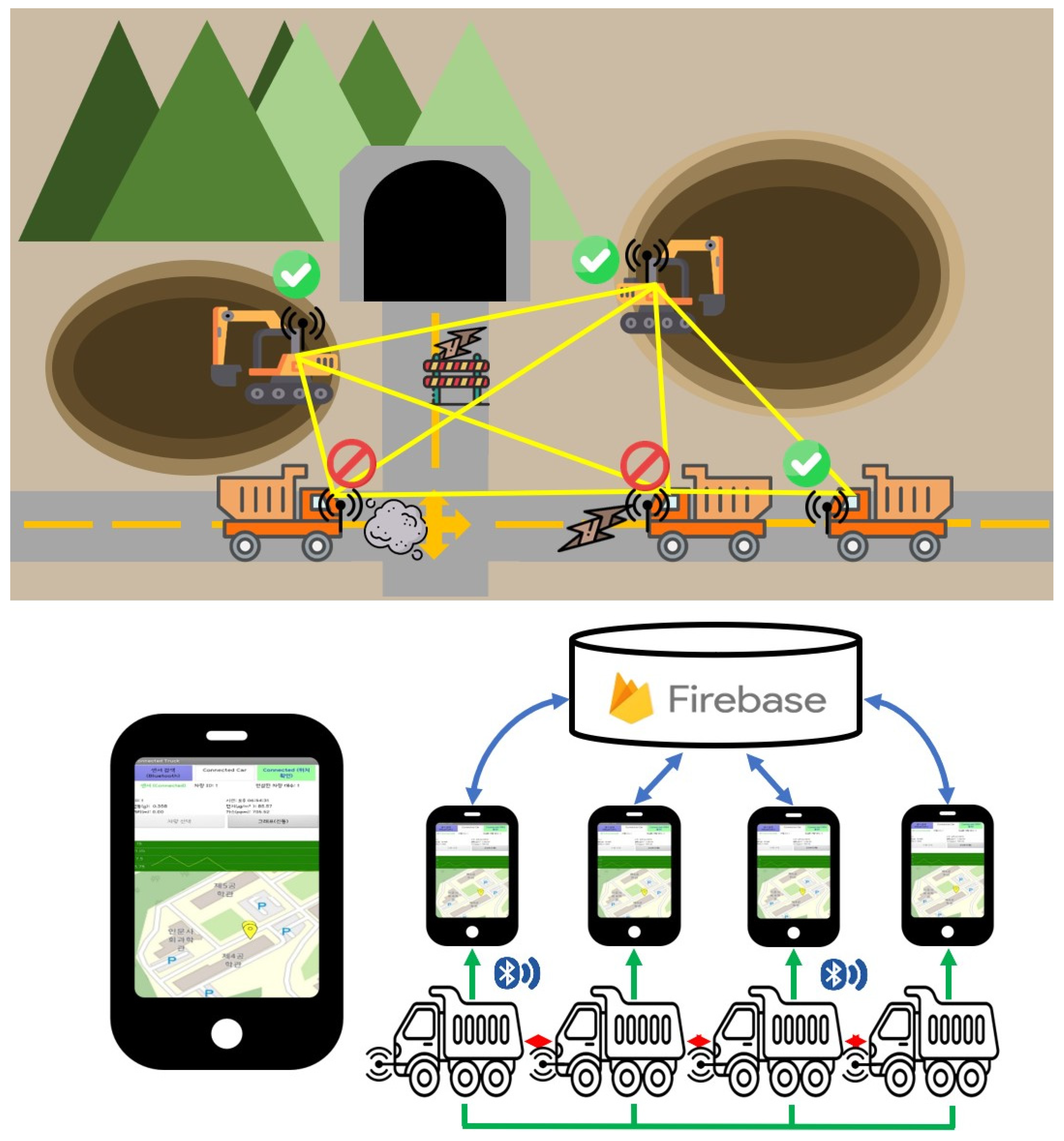
To monitor the external environment of the vehicle, we developed a digital device that can measure the roughness of the road surface, the amount of dust, and gas concentration using Arduino, a microcontroller, and various sensors. The detected data can be transmitted to a smartphone installed in the vehicle through a Bluetooth module, and the location and information can be exchanged among vehicles through an application. The developed application can allow the driver and drivers of other vehicles to check the results of measurements in individual vehicles (Figure 2).

3.1. Development of Digital Device Using Arduino and Sensors

This study used sensors to acquire data on dust density, gas concentration, and road surface conditions. A dust sensor (PMSA003) was used to measure the density of dust generated at the mining site (Figure 3A). PMSA003 is a type of digital and universal particle concentration sensor that can be used for obtaining the concentration of suspended particles in air. The sensor operates at −40 to 80 °C and can detect relatively small particles of <2.5 μm and particulate matter 2.5. The sensor detects dust based on the laser scattering principle using a laser to radiate suspended particles in the air and then collects scattered light. Furthermore, it predicts the dust density by obtaining the curve of the change in scattering light with time. It has an effective dust density range of up to 500 μg/m3 and a resolution of 1 μg/m3.
An MQ-135 gas sensor was used to measure the concentration of harmful gases that may have been emitted during the mining process (Figure 3B). The MQ-135 gas sensor detects gases such as ammonia, benzene, alcohol, and carbon dioxide at values ranging between approximately 10 and 1000 ppm and requires a preheating time of approximately 3 min to measure the correct value. Because the sensor’s sensitivity depends on the type of gas to be measured and the environment, calibration in a controlled environment is necessary for accurate measurements. However, because the Samdo mine, our case study, is a limestone mine, the emission of harmful gas is insignificant; thus, the precise correction process for individual sensors was omitted because the primary purpose was not to measure the exact gas concentration. All experiments were performed after preheating the sensor for at least 3 min to properly observe the change in the gas concentration.
A point-based light detection and ranging (LiDAR) sensor that can detect distances using light was used to understand the road surface conditions at the mining site. Garmin’s LiDAR-Lite v3HP (Figure 3C) was used, and the product could measure a distance from 5 cm to 40 m, with an accuracy of approximately 2.5 cm and a resolution of 1 cm. This study used LiDAR to identify the remote road surface conditions and risks in advance.
Although LiDAR allows one to indirectly identify the road surface conditions by measuring the distance from the road surface, vibration measurement can be a more direct indicator to quantify the direct impact on the vehicle. Various sensors can be used for vibration measurement; however, because this study used a smartphone, the vibration was measured using an inbuilt accelerometer in the smartphone. The accelerometer can measure acceleration in the X, Y, and Z directions around a specific axis of the sensor. Because the gravitational force always works even in the absence of vibration, a low-pass filter was applied to the acquired acceleration data to remove gravitational acceleration and quantify the vibration value.
Additionally, a spatial analysis of the data obtained from each sensor was performed, combined with location data. This study used a GPS sensor built into a smartphone to obtain vehicle location information.
Therefore, vibration and location measurements were performed using a smartphone, and other data were obtained using other sensors. These sensors were connected to an Arduino Uno microcontroller (Figure 3D), such that field information could be acquired in real time. Bluetooth module HC-05 (Figure 3E) was used to transmit the results to the smartphone. The product typically communicates within a distance of 10 m. A digital device combining Arduino and the sensors is shown in Figure 3F; the exterior was manufactured using a 3D printer.

3.2. Development of Data Sharing Application for the Smartphone

A digital device developed using Arduino and sensors transmitted values such as dust density, gas concentration, and road surface conditions to smartphones through Bluetooth modules. An application is required to receive and utilize such data on a smartphone. This study developed a smartphone application called Connected Mine using app inventor, a block-coding program developed at MIT [36]. The operation of the application can be divided into four main processes: (1) data acquisition from digital devices, (2) data acquisition from smartphone sensors, (3) data transfer to the server, and (4) reception of data stored on the server. The application aims to share information acquired using sensors or smartphones in real time and visualize it on a map.
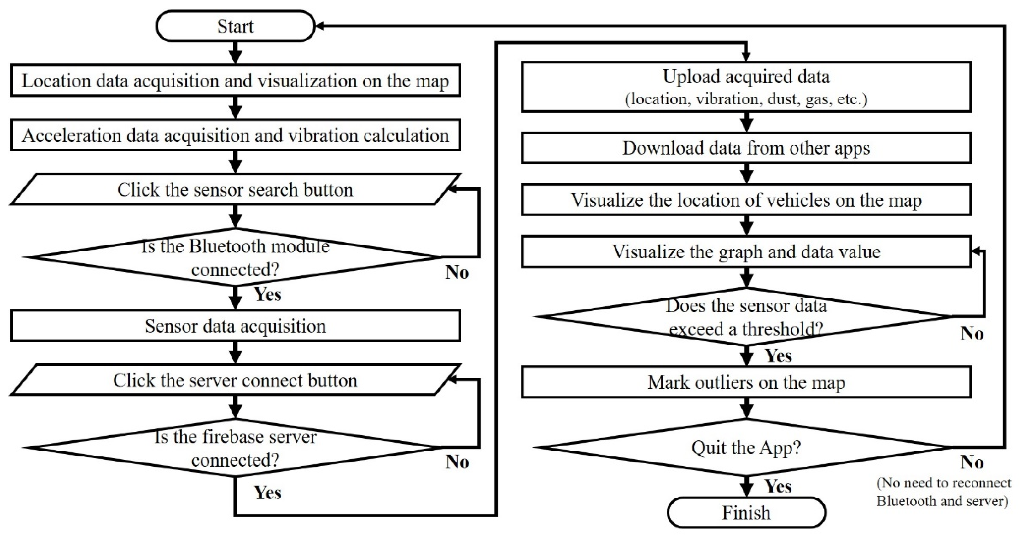
First, to receive data transmitted from a digital device, the Bluetooth communication function of the smartphone must be activated, and data from multiple sensors in one packet should be parsed. Second, the smartphone calculates the vibration using an accelerometer built into the smartphone, obtains location data using GPS, and combines it with previously received external sensor data. Third, it performs the real-time transmission of these continuously acquired data to the server. Currently, the number of vehicles (smartphones) is recorded in the data such that the vehicles that transmitted the data can be distinguished. This study used Firebase, a mobile and web application development platform, as the server. Finally, the data uploaded to the server are queried in real time and visualized on a map of the smartphone screen. Because the data transmitted to the server include the sensor and location data of each vehicle, the location of other vehicles moving in real time can be checked on the map. The interface and usage methods of the developed application are shown alphabetically in Figure 4. If the smartphone’s GPS sensor is activated, location information can be shared, such that the location of vehicles connected to the same server can be visualized on a map. When a value greater than a specific threshold is acquired from the sensor, it is marked on the screen. The flowchart of the functioning of the application is shown in Figure 5. As the accumulated data obtained from each application increase over time, the retrieval and storage of these data in the Firebase database are highly inefficient. Therefore, a data-logging Python code was developed instead of continuously recording all the data in the database. It connects to the Firebase server from a separate computer, retrieves the values acquired from the application in real time, and records them in a separate database. Thus, a big-data system that can store and analyze data obtained from all vehicles was built.

4. Results

4.1. Preliminary Test at the University

Prior to the application at the mining site, the developed digital device was attached to a RoboMaster S1 unit (Figure 6a), and a preliminary test was performed at Samcheok Campus, Kangwon National University. RoboMaster S1, developed by DJI, is a radio-controlled vehicle with video shooting and autonomous driving capabilities. It is equipped with a two-axis mechanical gimbal, a Mecanum wheel, and a high-performance motor. Additionally, it is equipped with advanced AI technology that supports the scratch and python programming languages. Because the roads at Samcheok Campus, Kangwon National University, are all paved, simulating an environment with rough road surface conditions is challenging, such as mine sites with ordinary vehicles. However, RoboMaster S1, a small radio-controlled vehicle, can perform experiments on rough terrain or unpaved paths. Furthermore, because RoboMaster S1 has a built-in battery, the power of the digital device is supplied by RoboMaster without requiring a separate battery to operate the device. The route of the RoboMaster for the preliminary test at Kangwon National University is shown in Figure 6b. Section 1 was a relatively flat paved road, and Section 2 was a rougher sandy road. After Section 2, the road was paved again, and Section 3 was adjacent to the road on which cars passed. The location and sensor measurements could be checked in real time through the developed application and recorded on a desktop computer using python codes.
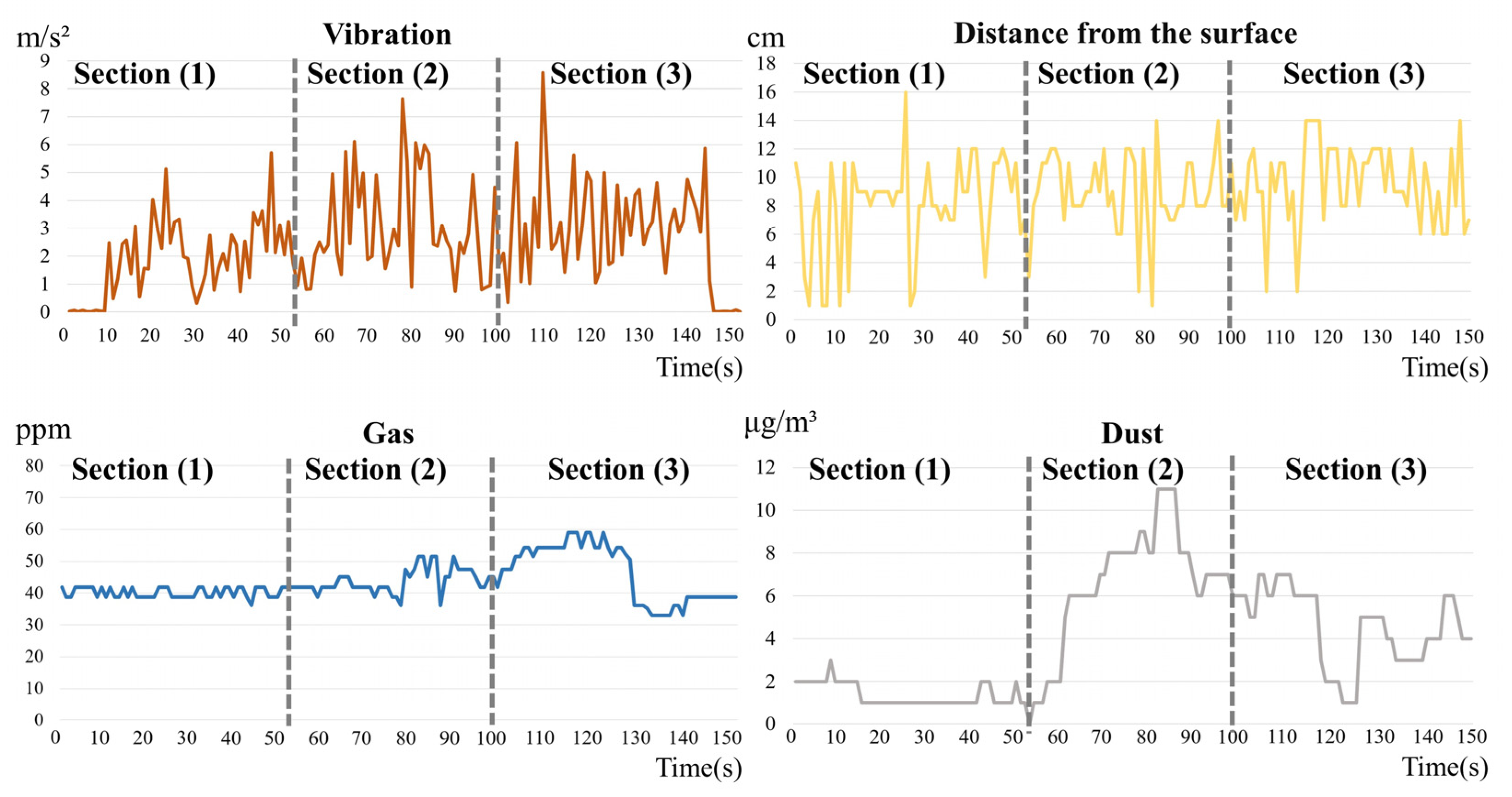
The data logging results obtained using the developed application are shown in Figure 7. RoboMaster S1 has a small body and wheels; therefore, a significant vibration was measured even on a relatively flat surface. Vibration values of up to 9 m/s2 were observed during the test. The distance to the ground using LiDAR also changed significantly. A distance of approximately 10 cm was measured on average. Distances ranging from 1 to 16 cm were recorded when the body of the RoboMaster vibrated during the test. Because RoboMaster S1 has a low height, only short-range results were obtained when using LiDAR; however, it can be used for longer-distance measurements in high-height dump trucks and heavy equipment. In Section 2, where the road surface was rough, the vibration and distance from the ground surface changed significantly. In addition, unlike other paved routes, Section 2 was an environment where dust could accumulate; thus, the dust density was seen to significantly increase up to 39 μg/m3. The gas sensor did not fluctuate significantly and maintained a generally constant value; however, the gas concentration increased in Section 3. This was because, during the test, vehicles passed along the adjacent road and emitted exhaust gases. Through a preliminary test, we confirmed that the developed application could detect, share, and record changes in the surrounding environment.

4.2. Field Test at the Samdo Mine

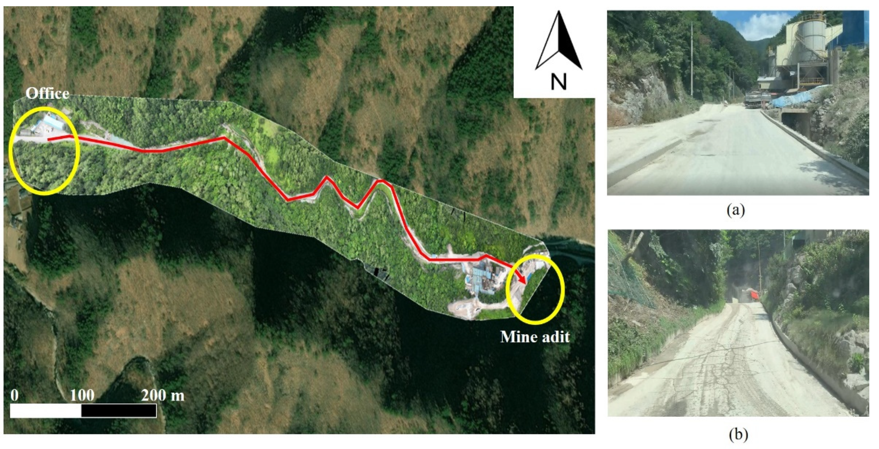
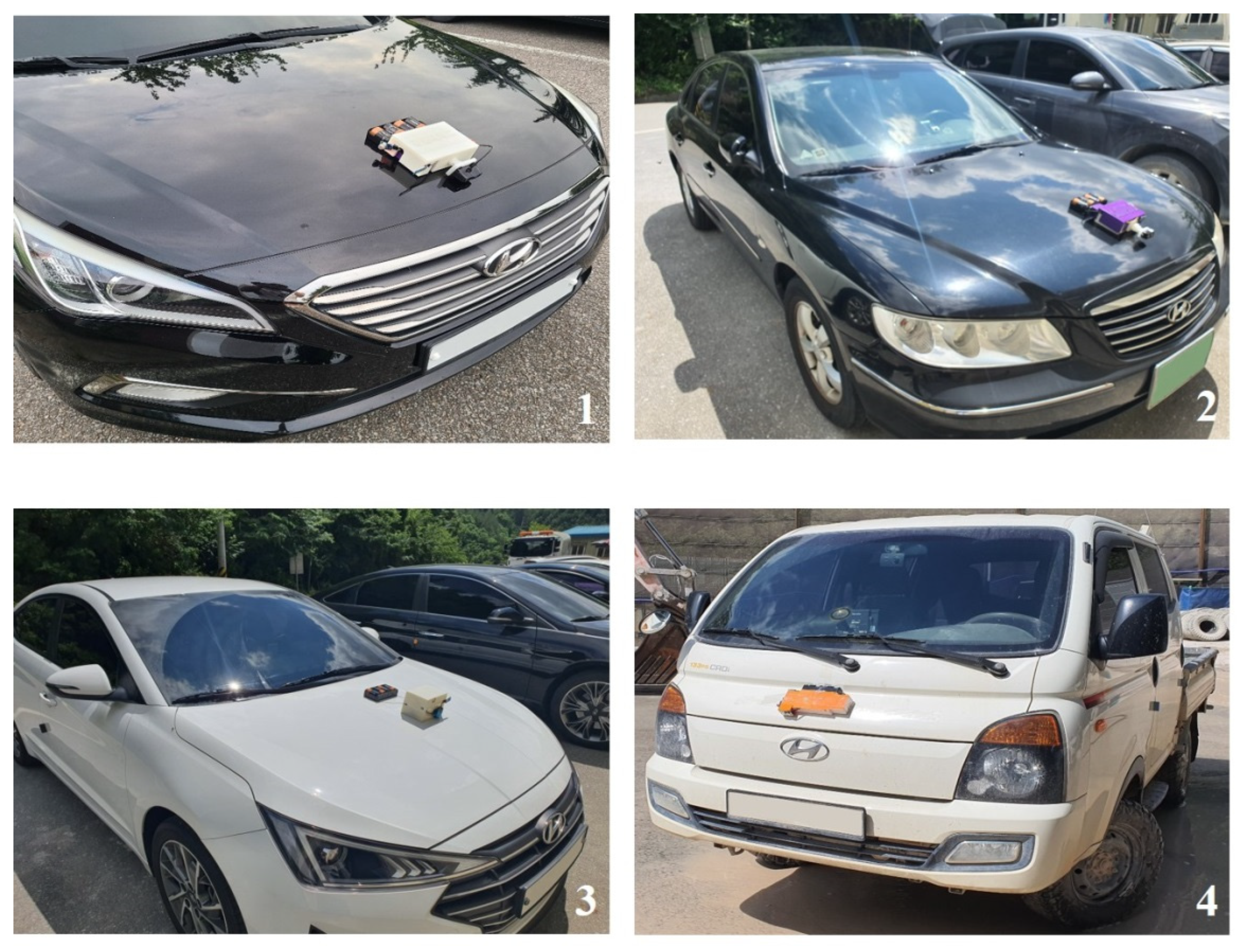
The developed system was installed on four vehicles, and field experiments were performed along the path from the office to the mine adit (Figure 8). The developed digital device was attached to the front of the vehicle, and a smartphone was installed inside the vehicle so that it could be checked by the driver. The experiment was conducted using a diesel truck and three sedans (Figure 9), and four vehicles moved back and forth along the route from the office to the mine adit. The movements of other vehicles could be checked in real time on each smartphone screen. The vibration, distance from the surface, gas concentration, and dust concentration measured for each vehicle are shown in Figure 10. Although the positions of the four vehicles slightly differed at a particular time, the sensor values showed a similar trend because they moved in succession while maintaining a close distance. The vibration, distance from the surface, and dust concentration changed significantly almost simultaneously, because the dust was generally generated in high-vibration areas. The gas concentration was high in the middle and at the end of the graphs. Because the experiment was conducted by having the test vehicles move back and forth from the office to the mine adit, the area of high gas concentration in the middle of the graph corresponded to the vicinity of the mine adit. The Samdo mine is a limestone mine; therefore, gas emission is not a significant problem. However, the high gas concentration was attributed to the numerous vehicles parked around the mine adit and office.
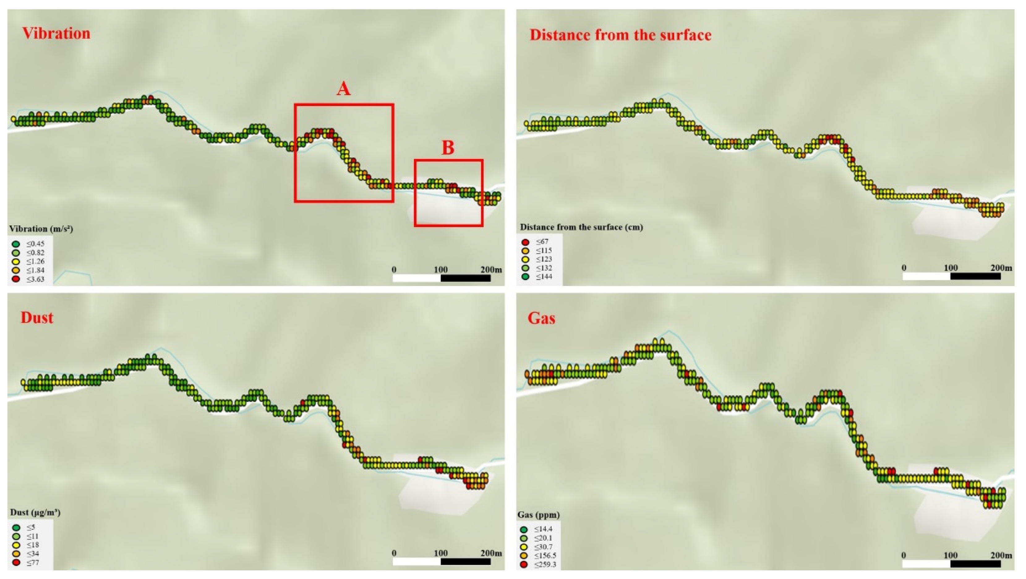
From the graphs, the changes in the values acquired through various sensors in each vehicle can be continuously checked; however, similarly determining the spatial distribution of the data is challenging. Because the data obtained in this study included location information through GPS, all the data of the four vehicles were averaged for the adjacent data using ArcGIS Pro and were subsequently visualized (Figure 11). The points indicating high vibration or a short distance from the surface are distributed in Sections A and B. Section A comprised the mineral processing facility and car wash facility (Figure 8a) for vehicles leaving the mine, and high vibration values were also observed around the mine adit (Figure 8b), corresponding to Section B. In Section A, the road surface was rough, and the road was narrow because of the car wash equipment on the side; therefore, vehicles should be driven with care. In Section B, vehicles shook significantly owing to a sudden change in the slope. Vehicles could move more stably if road conditions in these areas are improved. The dust concentration was generally low near the office; however, it was high near Sections A and B. This was because many vehicles and equipment were concentrated around the mine adit and mineral processing facility, and the dust washed from the car wash equipment accumulated on the top of the road, causing a dust wind when vehicles passed by. The gas concentration was relatively distributed and was high in the vicinity of the office and mine adit. This is because vehicle exhaust gas is the leading cause of the high gas concentration, and vehicles are mainly concentrated around the office and mine adit. In addition, as the vehicle continued to move, a high gas concentration was distributed over the entire route.

5. Conclusions

This study developed a technology that can monitor the environment of mining sites and share information among vehicles by attaching digital devices combined with various sensors. The dust density, gas concentration, and road surface conditions were observed at a mining site using a dust sensor, a gas sensor, and LiDAR, respectively. The vehicle’s location and vibration values were measured using GPS and accelerometers built into the smartphone. The data measured using the digital device were transmitted to the smartphone application through a Bluetooth module, and the sensor value could be checked in real time through the application. The Firebase database was used to share the data acquired from each vehicle, allowing each application to continuously upload its own data and receive data from other applications. Before applying the developed system to the mining site, a preliminary test was performed using RoboMaster S1, a wireless control vehicle, at Samcheok Campus, Kangwon National University. The measured data differed according to the road conditions. At the mining site, four vehicles were tested along a haulage road. The vibrations of the vehicles were high at the mine adit where the working vehicles were concentrated. Therefore, we concluded that the road surface required to be improved, or more attention should be paid to these areas. Because dust inevitably occurs during work, the dust density was relatively high at the mine adit; however, most workers wore dust masks and were in vehicles. Thus, direct harm was insignificant. However, long-term inhalation of dust can be harmful to the human body; therefore, workers working outside the vehicle should wear a dust mask with particular caution. In this study, the system was applied to ordinary vehicles to avoid interference with work at the mining site. However, in the future, we plan to improve the system and apply it to several field haulage trucks. Consequently, the battery system should be improved to connect the power of the vehicle to the developed digital device. In addition, the data processing method and server system should be improved such that data can be processed and shared quickly, even when many vehicles access the system. If multiple haulage trucks share information and accumulate data, a more reliable risk area analysis could be possible across the entire mine area through a big-data analysis in the future. Furthermore, if this study is combined with IoT-based underground mine communication technology, the locations of vehicles could be identified, and environmental data could be acquired within an underground mine.

Author Contributions

Conceptualization, S.-M.K.; Formal analysis, H.K.; Methodology, S.-M.K.; Software, H.K. and S.-M.K.; Writing—original draft, H.K., W.-H.L. and C.-H.L.; Writing—review and editing, S.-M.K. All authors have read and agreed to the published version of the manuscript.

Funding

This work was supported by (1) an Energy and Mineral Resources Development Association of Korea (EMRD) grant funded by the Korea government (MOTIE) (Data science based oil/gas exploration consortium) and (2) a 2019 research grant from Kangwon National University.

Conflicts of Interest

The authors declare no conflict of interest.

References

  1. S&P Global Market Intelligence. Available online: https://www.spglobal.com/marketintelligence/en/news-insights/latest-news-headlines/as-us-coal-demand-surged-worker-fatalities-doubled-yoy-in-2021-68234862 (accessed on 7 April 2022).
  2. Korea Resources Corporation (KORES). Mine Disaster Statistics Data; KORES: Wonju, Korea, 2020; pp. 1–175. [Google Scholar]
  3. Centers for Disease Control and Prevention. Available online: https://www.cdc.gov/niosh/mining/works/statistics/factsheets/miningfacts2015.html (accessed on 17 January 2022).
  4. Choi, Y.S.; Suh, J.W.; Park, H.D.; Sunwoo, C. Application of GIS-based Viewshed Analysis for Selecting Optimal Viewpoints and for Evaluating the Sight Distance on a Haul Road in Open-pit Mines. J. Korean Soc. Miner. Energy Resour. Eng. 2018, 45, 265–275. [Google Scholar]
  5. Choi, Y.S.; Park, H.D.; Sunwoo, C.; Clarke, K.C. Multi-criteria Evaluation and Least-cost Path Analysis for Optimal Haulage Routing of Dump Trucks in Large Scale Open-pit Mines. Int. J. Geogr. Inf. Sci. 2009, 23, 1541–1567. [Google Scholar] [CrossRef]
  6. Baek, J.E.; Choi, Y.S.; Lee, C.Y.; Suh, J.W.; Lee, S.H. BBUNS: Bluetooth Beacon-based Underground Navigation System to Support Mine Haulage Operations. Minerals 2017, 7, 228. [Google Scholar] [CrossRef] [Green Version]
  7. Baek, J.E.; Suh, J.W.; Choi, Y.S. Analysis of Received Signal Strength Index from Bluetooth Beacons to Develop Proximity Warning Systems for Underground Mines. J. Korean Soc. Miner. Energy Resour. Eng. 2018, 55, 604–613. [Google Scholar] [CrossRef]
  8. Sun, E.; Nieto, A.; Li, Z. GPS and Google Earth Based 3D Assisted Driving System for Trucks in Surface Mines. Min. Sci. Technol. 2010, 20, 138–142. [Google Scholar] [CrossRef]
  9. Sunwoo, C.; Jung, Y.B.; Choi, Y.S.; Park, H.D. Failure Prediction for Weak Rock Slopes in a Large Open-pit Mine by GPS Measurements and Assessment of Landslide Susceptibility. Eng. Geol. 2010, 20, 243–255. [Google Scholar]
  10. Park, S.B.; Choi, Y.S. Bluetooth Beacon-Based Mine Production Management Application to Support Ore Haulage Operations in Underground Mines. Sustainability 2021, 13, 2281. [Google Scholar] [CrossRef]
  11. Tang, S.; Fan, M.; Ma, G. Application of Bluetooth in Mine Gas Information Transmission. IOP Conf. Ser. Earth Environ. Sci. 2019, 242, 022014. [Google Scholar] [CrossRef]
  12. Nithya, T.; Ezak, M.M.; Kumar, K.R.; Vignesh, V.; Vimala, D. Rescue and Protection System for Underground Mine Workers Based On ZIGBEE. Int. J. Rec. Res. Asp. 2017, 4, 194–197. [Google Scholar]
  13. Bin, G.; Li, H. The research on ZigBee-based mine safety monitoring system. In Proceedings of the International Conference on Electric Information and Control Engineering, Wuhan, China, 15–17 April 2011; pp. 1837–1840. [Google Scholar]
  14. Liu, X.; Huang, J.S.; Chen, Z. The Research of Ranging with Timing over Packet Network for the Mine Safety Application. J. Netw. 2012, 7, 1054–1062. [Google Scholar] [CrossRef]
  15. Min, C.; Jinhao, Z. The Application of WiFi 6 Technology in Underground Mine. IOP Conf. Ser. Earth Environ. Sci. 2021, 687, 012153. [Google Scholar] [CrossRef]
  16. Lee, W.H.; Kim, H.; Lee, C.H.; Kim, S.M. Development of Vibration and Dust Monitoring Technology in Underground Mines using Zigbee-based Wireless Sensor Network. J. Korean Soc. Miner. Energy Resour. Eng. 2022, 59, 137–147. [Google Scholar] [CrossRef]
  17. Park, Y.H.; Lee, H.K.; Seo, M.K.; Kim, J. A Study on the Application of Real-time Environment Monitoring System in Underground Mines Using Zigbee. Tunn. Undergr. 2019, 29, 108–123. [Google Scholar]
  18. Kim, S.M. Review of Internet of Things and Open-source Hardware Technologies Use in the Mining Industry. J. Korean Soc. Miner. Energy Resour. Eng. 2019, 56, 447–456. [Google Scholar] [CrossRef]
  19. Kim, S.M.; Choi, Y.S.; Suh, J.W. Applications of the Open-source Hardware Arduino Platform in the Mining Industry: A review. Appl. Sci. 2020, 10, 5018. [Google Scholar] [CrossRef]
  20. Meocci, M.; Branzi, V. Black boxes data for road pavement conditions monitoring: A case study in Florence. In Proceedings of the 11th International Conference on the Bearing Capacity of Roads, Railways and Airfields, Trondheim, Norway, 27–30 June 2022; pp. 271–280. [Google Scholar]
  21. Singh, P.; Bansal, A.; Kamal, A.E.; Kumar, S. Road monitoring and sensing system using mobile sensors. In Proceedings of the 12th International Conference on Cloud Computing, Data Science & Engineering (Confluence), Uttar Pradesh, India, 27–28 January 2022; pp. 165–170. [Google Scholar]
  22. Setiawan, B.D.; Kovacs, M.; Serdült, U.; Kryssanov, V. Semantic segmentation on smartphone motion sensor data for road surface monitoring. Procedia Comput. Sci. 2022, 204, 346–353. [Google Scholar] [CrossRef]
  23. Kumar, T.; Acharya, D.; Lohani, D. Modeling IoT enabled classification system for road surface monitoring. In Proceedings of the 14th International Conference on COMmunication Systems & NETworkS (COMSNETS), Bengaluru, India, 3–9 January 2022; pp. 836–841. [Google Scholar]
  24. Sattar, S.; Li, S.; Chapman, M. Developing a near real-time road surface anomaly detection approach for road surface monitoring. Measurement 2021, 185, 109990. [Google Scholar] [CrossRef]
  25. Partridge, T.; Gherman, L.; Morris, D.; Light, R.; Leslie, A.; Sharkey, D.; McNally, D.; Crowe, J. Smartphone monitoring of in-ambulance vibration and noise. J. Eng. Med. 2021, 235, 428–436. [Google Scholar] [CrossRef]
  26. New Civil Engineer. Available online: https://www.newcivilengineer.com/innovative-thinking/connected-sensors-to-monitor-scotlands-rural-roads-26-07-2022 (accessed on 6 October 2022).
  27. Intel. Available online: https://www.intel.co.kr/content/www/kr/ko/transportation/smart-road-infrastructure.html (accessed on 7 October 2022).
  28. Od, S.; Hsu, H.C.; Wei, J.B. Improve the indoor air quality based on internet of things. In Proceedings of the IEEE 3rd Eurasia Conference on Biomedical Engineering, Healthcare and Sustainability (ECBIOS), Tainan, Taiwan, 28–30 May 2021; pp. 105–108. [Google Scholar]
  29. Jabbar, W.A.; Subramaniam, T.; Ong, A.E.; Shu’Ib, M.I.; Wu, W.; de Oliveira, M.A. LoRaWAN-based IoT system implementation for long-range outdoor air quality monitoring. Internet Things 2022, 19, 100540. [Google Scholar] [CrossRef]
  30. Jumaa, N.K.; Abdulkhaleq, Y.M.; Nadhim, M.A.; Abbas, T.A. IoT Based Gas Leakage Detection and Alarming System using Blynk platforms. Iraqi J. Electr. Electron. Eng. 2022, 18, 64–70. [Google Scholar] [CrossRef]
  31. Yadav, H.; Oyiza, N.; Hassan, S.; Lata, S.; Chitra, K.J. IoT based industrial monitoring system. Int. Res. J. Mod. Eng. Technol. Sci. 2022, 4, 2474–2479. [Google Scholar]
  32. Khan, A.; Chandra, S.; Parameshwara, M.C. Air quality monitoring and management system model of vehicles based on the internet of things. Eng. Res. Expr. 2022, 4, 025014. [Google Scholar] [CrossRef]
  33. Pulse. Available online: https://pulsenews.co.kr/view.php?sc=30800028&year=2020&no=291177 (accessed on 1 October 2022).
  34. Park, Y.K. Connected Car Based on IoT, Smart Car. Smart Media J. 2014, 3, 29–31. [Google Scholar]
  35. Digital Times. Available online: http://www.dt.co.kr/contents.html?article_no=2019102302101331032001 (accessed on 2 May 2022).
  36. MIT App Inventor. Available online: http://appinventor.mit.edu/explore (accessed on 22 January 2022).
Figure 1. (a) Panoramic image, (b) DSM, (c) orthoimage, and (d) three-dimensional image of Taeyoung EMC’s Samdo mine.
Applsci 12 12166 g001
Figure 2. Concept of information sharing among vehicles through a smartphone application.
Applsci 12 12166 g002
Figure 3. (A) Dust sensor, (B) gas sensor, (C) LiDAR, (D) Arduino Uno, (E) Bluetooth module, and (F) a digital device that combines Arduino and sensors.
Applsci 12 12166 g003
Figure 4. Interface of developed smartphone application. (a) Bluetooth sensor search button, (b) searched Bluetooth modules, (c) graph selection window, (d) selected graph, (e) database name input box, (f) server connect button, and (g) vehicle selection window.
Applsci 12 12166 g004
Figure 5. Flowchart showing the procedures in which the Connected Mine application works.
Applsci 12 12166 g005
Figure 6. Images of (a) RoboMaster S1 and (b) preliminary test site (Samcheok Campus, Kangwon National University).
Applsci 12 12166 g006
Figure 7. Data logging results of vibration, distance from the surface, gas concentration, and dust concentration.
Applsci 12 12166 g007
Figure 8. Route from the office to the mine adit for the application of the developed system, (a) a photo of the mineral processing facility and water facility, and (b) a photo of the mine adit.
Applsci 12 12166 g008
Figure 9. Photos of vehicles and installed digital devices used in the experiment.
Applsci 12 12166 g009
Figure 10. Data logging result graphs of the experimental results of four vehicles.
Applsci 12 12166 g010
Figure 11. Analysis results of the spatial distributions of vibration, distance from the surface, dust concentration, and gas concentration. Sections A and B have rough road conditions.
Applsci 12 12166 g011
Table 1. Summary of IoT applications to monitor road conditions and air quality.
Sub-FieldReferencesYearReal-Time Data SharingPositioningAim of Study
Road conditionsMeocci and Branzi [20]2022NoNoRoad condition monitoring using the acceleration measurement function of the black box
Singh et al. [21]2022NoNoRoad condition monitoring using smartphone built-in motion sensors
Setiawan et al. [22]2022NoNoRoad condition monitoring using smartphone built-in motion sensors
Kumar et al. [23]2022NoYesRoad condition monitoring using smartphone built-in motion sensors
Sattar et al. [24]2021NoYesRoad condition monitoring using smartphone built-in motion sensors
Partridge et al. [25]2020NoNoRoad vibration and noise monitoring using a smartphone for an ambulance
Air qualityOd et al. [28]2021YesNoAir quality monitoring using PM2.5 and CO2 sensors with a smartphone application
Jabbar et al. [29]2022YesNoAir quality monitoring using various sensors with a smartphone application
Jumaa et al. [30]2022YesNoGas leakage detection and alarm system with a smartphone application
Yadav et al. [31]2022YesNoIndustrial monitoring using temperature, humidity, and smoke sensors
Khan et al. [32]2022YesYesAir quality monitoring using various sensors and GPS for vehicles
Publisher’s Note: MDPI stays neutral with regard to jurisdictional claims in published maps and institutional affiliations.