
An Improved Shoulder Line Extraction Method Fusing Edge Detection and Regional Growing Algorithm


Abstract
:1. Introduction
2. Materials and Methods
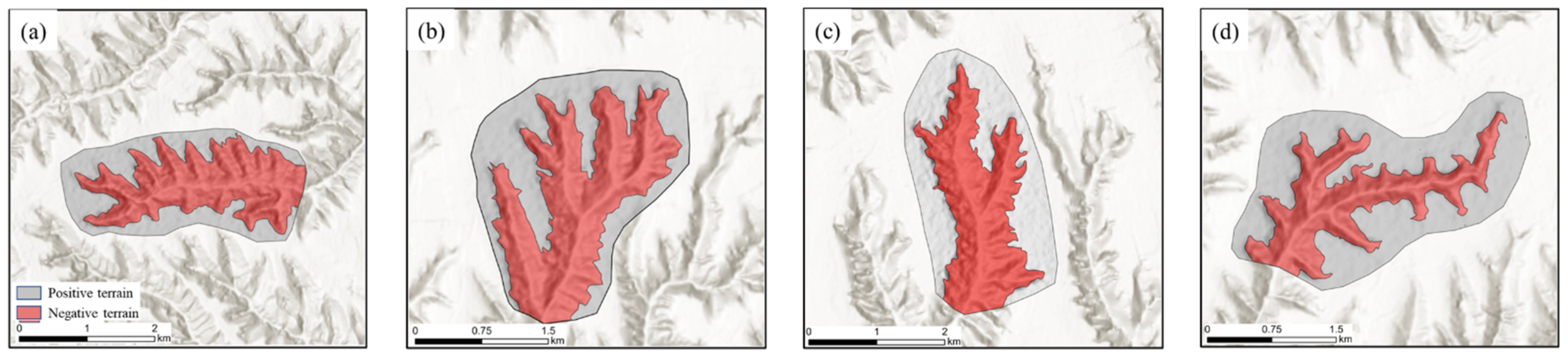
2.1. Study Areas
2.2. Data
2.3. Edge Detection
2.3.1. Image Grayscale
2.3.2. Binary Image
2.3.3. Canny Edge Detection
2.4. Regional Growing Algorithm
2.4.1. Identifying Growing Points for P-N Terrain
2.4.2. Growth Criteria
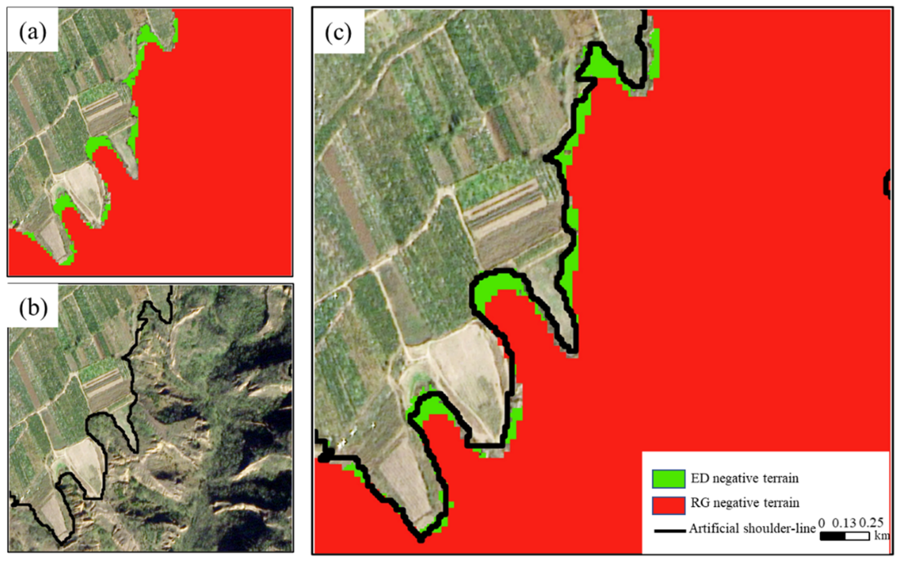
2.5. Burr Removal
2.6. Accuracy Assessments
3. Results
3.1. Parameter Settings
3.2. Results Analysis
3.3. Precision Evaluation
4. Discussion
4.1. Comparison of Different Operators
4.2. Applications and Future Research
5. Conclusions
Author Contributions
Funding
Institutional Review Board Statement
Informed Consent Statement
Data Availability Statement
Conflicts of Interest
References
- Li, S.; Xiong, L.; Tang, G.; Strobl, J. Deep Learning-Based Approach for Landform Classification from Integrated Data Sources of Digital Elevation Model and Imagery. Geomorphology 2020, 354, 107045. [Google Scholar] [CrossRef]
- Rokosh, D.; Bush, A.B.; Rutter, N.W.; Ding, Z.; Sun, J. Hydrologic and Geologic Factors That Influenced Spatial Variations in Loess Deposition in China during the Last Interglacial–Glacial Cycle: Results from Proxy Climate and GCM Analyses. Palaeogeogr. Palaeoclimatol. Palaeoecol. 2003, 193, 249–260. [Google Scholar] [CrossRef]
- Chen, L.; Wei, W.; Fu, B.; Lü, Y. Soil and Water Conservation on the Loess Plateau in China: Review and Perspective. Prog. Phys. Geogr. 2007, 31, 389–403. [Google Scholar] [CrossRef]
- Chen, Y. Types of valleys in the loess hilly area in the middle reaches of the Yellow River. Sci. Geogr. Sin. 1984, 4, 321–327. [Google Scholar]
- Zhao, G.; Mu, X.; Wen, Z.; Wang, F.; Gao, P. Soil Erosion, Conservation, and Eco-Environment Changes in the Loess Plateau of China. Land Degrad. Dev. 2013, 24, 499–510. [Google Scholar] [CrossRef]
- Perroy, R.L.; Bookhagen, B.; Asner, G.P.; Chadwick, O.A. Comparison of Gully Erosion Estimates Using Airborne and Ground-Based LiDAR on Santa Cruz Island, California. Geomorphology 2010, 118, 288–300. [Google Scholar] [CrossRef]
- Jiang, S.; Tang, G.; Liu, K. A New Extraction Method of Loess Shoulder line Based on Marr-Hildreth Operator and Terrain Mask. PLoS ONE 2015, 10, e0123804. [Google Scholar] [CrossRef]
- Yang, X.; Li, M.; Na, J.; Liu, K. Gully Boundary Extraction Based on Multidirectional Hill-Shading from High-Resolution DEMs. Trans. GIS 2017, 21, 1204–1216. [Google Scholar] [CrossRef]
- Ke, W.; Cheng, W.; Qingfeng, Z.; Kailong, D. Loess Shoulder Line Extraction Based on Openness and Threshold Segmentation. Acta Geod. Cartogr. Sin. 2015, 44, 67–75. [Google Scholar]
- Dai, W.; Yang, X.; Na, J.; Li, J.; Brus, D.; Xiong, L.; Tang, G.; Huang, X. Effects of DEM Resolution on the Accuracy of Gully Maps in Loess Hilly Areas. Catena 2019, 177, 114–125. [Google Scholar] [CrossRef]
- Daba, S.; Rieger, W.; Strauss, P. Assessment of Gully Erosion in Eastern Ethiopia Using Photogrammetric Techniques. Catena 2003, 50, 273–291. [Google Scholar] [CrossRef]
- Castillo, C.; Pérez, R.; James, M.R.; Quinton, J.N.; Taguas, E.V.; Gómez, J.A. Comparing the Accuracy of Several Field Methods for Measuring Gully Erosion. Soil Sci. Soc. Am. J. 2012, 76, 1319–1332. [Google Scholar] [CrossRef]
- Fadul, H.M.; Salih, A.A.; Imad-eldin, A.A.; Inanaga, S. Use of Remote Sensing to Map Gully Erosion along the Atbara River, Sudan. Int. J. Appl. Earth Obs. Geoinf. 1999, 1, 175–180. [Google Scholar] [CrossRef]
- Shruthi, R.B.; Kerle, N.; Jetten, V. Object-Based Gully Feature Extraction Using High Spatial Resolution Imagery. Geomorphology 2011, 134, 260–268. [Google Scholar] [CrossRef]
- Seutloali, K.E.; Beckedahl, H.R.; Dube, T.; Sibanda, M. An Assessment of Gully Erosion along Major Armoured Roads in South-Eastern Region of South Africa: A Remote Sensing and GIS Approach. Geocarto Int. 2016, 31, 225–239. [Google Scholar] [CrossRef]
- Gafurov, A.M.; Yermolayev, O.P. Automatic Gully Detection: Neural Networks and Computer Vision. Remote Sens. 2020, 12, 1743. [Google Scholar] [CrossRef]
- Lv, G.; Xiong, L.; Chen, M.; Tang, G.; Sheng, Y.; Liu, X.; Song, Z.; Lu, Y.; Yu, Z.; Zhang, K. Chinese Progress in Geomorphometry. J. Geogr. Sci. 2017, 27, 1389–1412. [Google Scholar] [CrossRef]
- Cheng, W.; Liu, Q.; Zhao, S.; Gao, X.; Wang, N. Research and Perspectives on Geomorphology in China: Four Decades in Retrospect. J. Geogr. Sci. 2017, 27, 1283–1310. [Google Scholar] [CrossRef] [Green Version]
- Castillo, C.; Taguas, E.V.; Zarco-Tejada, P.; James, M.R.; Gómez, J.A. The Normalized Topographic Method: An Automated Procedure for Gully Mapping Using GIS. Earth Surf. Process. Landf. 2014, 39, 2002–2015. [Google Scholar] [CrossRef]
- Golosov, V.; Yermolaev, O.; Rysin, I.; Vanmaercke, M.; Medvedeva, R.; Zaytseva, M. Mapping and Spatial-Temporal Assessment of Gully Density in the Middle Volga Region, Russia. Earth Surf. Process. Landf. 2018, 43, 2818–2834. [Google Scholar] [CrossRef]
- Wei, H.; Li, S.; Li, C.; Zhao, F.; Xiong, L.; Tang, G. Quantification of Loess Landforms from Three-Dimensional Landscape Pattern Perspective by Using DEMs. ISPRS Int. J. Geo-Inf. 2021, 10, 693. [Google Scholar] [CrossRef]
- Evans, M.; Lindsay, J. High Resolution Quantification of Gully Erosion in Upland Peatlands at the Landscape Scale. Earth Surf. Process. Landf. 2010, 35, 876–886. [Google Scholar] [CrossRef]
- Lei, X.; Zhou, Y.; Li, Y.; Wang, Z. Construction and characteristic analysis of loess landform approximation factor based on DEM. J. Geo-Inf. Sci. 2020, 22, 431–441. [Google Scholar]
- Xiao, C.; Tang, G. Classification of valley shoulder line in Loess Relief. Arid. Land Geogr. 2007, 30, 646–653. [Google Scholar]
- Lv, G.; Qian, Y.; Chen, Z. Research on automatic extraction of loess landform shoulder line based on grid digital elevation model. Sci. Geogr. Sin. 1998, 18, 567–573. [Google Scholar]
- Liu, P.; Zhu, Q.; Wu, D.; Zhu, J.; Tang, X. Research on automatic extraction technology of loess area shoulder line based on grid DEM and water flow path. J. Beijing For. Univ. 2006, 28, 72–76. [Google Scholar]
- Yang, F.; Zhou, Y.; Chen, M. Shoulder line constrained loess water-erodible gully extraction. Mt. Res. 2016, 34, 504–510. [Google Scholar]
- Vrieling, A.; Rodrigues, S.C.; Bartholomeus, H.; Sterk, G. Automatic Identification of Erosion Gullies with ASTER Imagery in the Brazilian Cerrados. Int. J. Remote Sens. 2007, 28, 2723–2738. [Google Scholar] [CrossRef]
- Yan, S.; Tang, G.; Li, F.; Dong, Y. Automatic extraction of loess landform lines using DEM edge detection. Geomat. Inf. Sci. Wuhan Univ. 2011, 36, 363–366. [Google Scholar]
- Wang, K.; Wang, Z.; Zhang, Q.; Ding, K. A Loess Plateau shoulder line Extraction Method Combining Topographic Opening and Differential Image Threshold Segmentation. Acta Geod. Cartogr. Sin. 2015, 44, 67–75. [Google Scholar]
- Lira, J.; Maletti, G. A Supervised Contextual Classifier Based on a Region-Growth Algorithm. Comput. Geosci. 2002, 28, 951–959. [Google Scholar] [CrossRef]
- Ghule, A.G.; Deshmukh, P.R. Image Segmentation Available Techniques, Open Issues and Region Growing Algorithm. J. Signal Image Process. 2012, 3, 71–75. [Google Scholar]
- Liu, W.; Li, F.Y.; Xiong, L.Y.; Liu, S.L.; Wang, K. Shoulder Line Extraction in the Loess Plateau Based on Region Growing Algorithm. Int. J. Georgr. Inf. Sci. 2016, 18, 220–226. [Google Scholar]
- Basu, M. Gaussian-Based Edge-Detection Methods-a Survey. IEEE Trans. Syst. Man Cybern. Part C Appl. Rev. 2002, 32, 252–260. [Google Scholar] [CrossRef] [Green Version]
- Canny, J. A Computational Approach to Edge Detection. IEEE Trans. Pattern Anal. Mach. Intell. 1986, PAMI-8, 679–698. [Google Scholar] [CrossRef]
- Zhang, Z.; Wang, Y.; Xue, G. Digital Image Processing and Computer Vision—Visual C++ and Matlab Implementation; People’s Posts and Telecommunications Press: Beijing, China, 2010; 368p. [Google Scholar]
- Xiong, L.; Tang, G.; Yan, S.; Zhu, S.; Sun, Y. Landform-Oriented Flow-Routing Algorithm for the Dual-Structure Loess Terrain Based on Digital Elevation Models: Flow-Routing Algorithms for the Dual-Structure Loess Terrain. Hydrol. Process. 2014, 28, 1756–1766. [Google Scholar] [CrossRef]
- Xiong, L.-Y.; Tang, G.-A.; Li, F.-Y.; Yuan, B.-Y.; Lu, Z.-C. Modeling the Evolution of Loess-Covered Landforms in the Loess Plateau of China Using a DEM of Underground Bedrock Surface. Geomorphology 2014, 209, 18–26. [Google Scholar] [CrossRef]
- McVicar, T.R.; Van Niel, T.G.; Li, L.; Wen, Z.; Yang, Q.; Li, R.; Jiao, F. Parsimoniously Modelling Perennial Vegetation Suitability and Identifying Priority Areas to Support China’s Re-Vegetation Program in the Loess Plateau: Matching Model Complexity to Data Availability. For. Ecol. Manag. 2010, 259, 1277–1290. [Google Scholar] [CrossRef]
- Wei, H.; Xiong, L.; Zhao, F.; Tang, G.; Lane, S.N. Large-Scale Spatial Variability in Loess Landforms and Their Evolution, Luohe River Basin, Chinese Loess Plateau. Geomorphology 2022, 415, 108407. [Google Scholar] [CrossRef]


| Data Name | Type | Resolution | Data Resource |
|---|---|---|---|
| Satellite images | Raster | 3 m | https://www.planet.com/explorer/ (accessed on 1 September 2021) |
| DEM | Raster | 12.5 m | https://search.asf.alaska.edu/#/ (accessed on 1 October 2016) |
| Vector boundaries data | Vector | — | 1:250,000 national basic geographic database |
| Method | Indicator | Sample Area a | Sample Area b | Sample Area c | Sample Area d |
|---|---|---|---|---|---|
| Manual visual interpretation | negative terrain area (ha) | 320.912 | 328.762 | 347.209 | 197.833 |
| Regional growing algorithm | negative terrain area (ha) | 328.624 | 317.811 | 334.249 | 189.325 |
| percent error | 2.403% | 3.331% | 3.733% | 4.301% | |
| absolute error | 7.712 | 10.951 | 12.960 | 8.508 | |
| Edge detection | negative terrain area (ha) | 280.713 | 290.678 | 317.581 | 176.741 |
| percent error | 12.526% | 11.584% | 8.533% | 10.662% | |
| absolute error | 40.199 | 38.084 | 29.628 | 21.092 |
| Sample Area | Method | CPA | PA | Dice | IOU |
|---|---|---|---|---|---|
| Edge detection | 0.814 | 0.791 | 0.818 | 0.734 | |
| a | Regional growing algorithm | 0.829 | 0.807 | 0.820 | 0.813 |
| Method in this study | 0.885 | 0.864 | 0.877 | 0.907 | |
| Edge detection | 0.837 | 0.797 | 0.820 | 0.828 | |
| b | Regional growing algorithm | 0.831 | 0.845 | 0.815 | 0.836 |
| Method in this study | 0.897 | 0.858 | 0.871 | 0.891 | |
| Edge detection | 0.776 | 0.801 | 0.843 | 0.794 | |
| c | Regional growing algorithm | 0.819 | 0.836 | 0.833 | 0.857 |
| Method in this study | 0.867 | 0.917 | 0.866 | 0.897 | |
| Edge detection | 0.801 | 0.799 | 0.791 | 0.747 | |
| d | Regional growing algorithm | 0.811 | 0.781 | 0.831 | 0.811 |
| Method in this study | 0.873 | 0.911 | 0.859 | 0.909 |
| Operator Type | Number of Lines | Maximum Length (m) | Total Length (m) |
|---|---|---|---|
| Prewitt | 427 | 12,116 | 21,033 |
| Sobel | 514 | 6283 | 23,877 |
| Robert’s | 441 | 9867 | 23,196 |
| Laplace | 154 | 17,421 | 22,966 |
| Canny | 87 | 19,308 | 22,393.8 |
Publisher’s Note: MDPI stays neutral with regard to jurisdictional claims in published maps and institutional affiliations. |
© 2022 by the authors. Licensee MDPI, Basel, Switzerland. This article is an open access article distributed under the terms and conditions of the Creative Commons Attribution (CC BY) license (https://creativecommons.org/licenses/by/4.0/).
Share and Cite
Jiao, H.; Li, F.; Wei, H.; Liu, W. An Improved Shoulder Line Extraction Method Fusing Edge Detection and Regional Growing Algorithm. Appl. Sci. 2022, 12, 12662. https://doi.org/10.3390/app122412662
Jiao H, Li F, Wei H, Liu W. An Improved Shoulder Line Extraction Method Fusing Edge Detection and Regional Growing Algorithm. Applied Sciences. 2022; 12(24):12662. https://doi.org/10.3390/app122412662
Chicago/Turabian StyleJiao, Haoyang, Fayuan Li, Hong Wei, and Wei Liu. 2022. "An Improved Shoulder Line Extraction Method Fusing Edge Detection and Regional Growing Algorithm" Applied Sciences 12, no. 24: 12662. https://doi.org/10.3390/app122412662
APA StyleJiao, H., Li, F., Wei, H., & Liu, W. (2022). An Improved Shoulder Line Extraction Method Fusing Edge Detection and Regional Growing Algorithm. Applied Sciences, 12(24), 12662. https://doi.org/10.3390/app122412662